|
|
|
- Ginger Fields
- 5 years ago
- Views:
Transcription
1
2
3
4
5
6

7

8

9
10

11
12


13
14

15

16
17
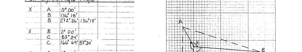
18 Cabrillo College Engineering 1A - Surveying LABORATORY NO THEODOLITE: ANGLE ABOUT A POINT Objectives: To measure the angles about a point by repetition using a theodolite. Equipment: Theodolite, tripod, carpenter s level (?) Procedure: (1) Each survey crew will choose one of the triangles used in Lab No. 2. (2) Set up your tripod (without the theodolite) in the center of your triangle so that the plate (flat part on top) is approximately horizontal. (3) Connect the theodolite to the tripod by use of the screw under the tripod. Position the theodolite in the center of the tripod. (4) Level your instrument and rotate the theodolite in different positions (90, 180, 270, & 360 ) ensuring that the instrument is indeed leveled. (5) Once leveled, look through the optical plumb. The location you see on the ground will be Point X. (6) Check the leveling and repeat Step No. 5 if necessary. (7) Focus the telescope and the eyepiece to eliminate parallax. (8) Measure the angle clockwise between Points A & B, Points B & C, and Points C & A with the angle set back to zero at the start of each measurement. The angles will be measured by repetition (demonstrated in class). Report the angle to the smallest increment that can be measured with your theodolite. Note: Each survey crew member will have her/his own notes. (9) Compute the average angle from the angles measured by repetition. (10) Sum up the average measured angles. (11) Compute the angle closure as compared to ' or ' 00". Rev 10/5/ kh

19
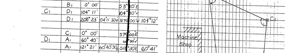
20 Cabrillo College Engineering 1A - Surveying 113 LABORATORY NO THEODOLITE: INTERIOR ANGLES Objectives: To measure the interior angles of a triangle by repetition using a theodolite. Equipment: Theodolite, Tripod, Carpenter s Level (?) Procedure: (1) A triangle with a set of three monuments (ginnies) labeled A, B and C will be assigned to each party. (2) Set up your tripod (without the theodolite) over Point A so that the plate is approximately horizontal. (3) Connect the theodolite to the tripod by use of the screw under the tripod. Position the theodolite in the center of the tripod. (4) Check height of instrument, making sure eyepiece is at a comfortable height to look through. (5) Step down on one leg of the tri-pod and position yourself on the opposite side of the tripod between the two other legs. (6) Adjust legs to level top plate of tripod. (7) Look through the optical plumb while holding onto two tripod legs. Using the third (opposite leg) as a pivot point, rotate or move up and down until you see the tac through the optical plumb. (8) Level your instrument and rotate the theodolite in different positions (90, 180, 270, & 360 ) ensuring that the instrument is indeed leveled. (9) If the optical plumb does not site in the center of the iron stake, loosen the screw connecting the theodolite and the tripod (do not unscrew completely) and slide the theodolite along the plate until the optical plumb sites in the center of the iron marker. (10) Check the leveling and repeat from Step No. 4 if necessary. (11) Focus the telescope and the eyepiece to eliminate parallax. (12) Measure angle A by siting in Point B at 00 00' 00" and turning the theodolite clockwise to Point C. The angles will be measured by repetition. NOTE: Report all angles to the smallest increment that can be measured with your theodolite. (13) Move theodolite and set up on Point B. Repeat Steps 3 to 7. (14) Measure angle B by sitting in Point C at 00 00' 00" and turning the transit clockwise to Point A. The angles will be measured by repetition. Rev 10/5/ kh
21 113A (15) Move transit and set up on Point C. Repeat Steps 3 to 7. (16) Measure angle C by sitting in Point A at 00 00' 00" and turning the transit clockwise to Point B. The angles will be measured by repetition. (17) No magnet bearings will be measured for this lab. Computations: (1) Compute the average interior angles of the triangle from the angles measured by repetition. (2) Sum up the average measured angles. Be sure that the sum is within 01' N of the theoretical sum of ' 00", where N is the number of setups. (3) Adjust the angles by applying equal corrections to each angle. Adjusted values should be rounded off to the nearest 10, 1, 30", 10, etc... (whichever is the smallest increment of your instrument).


22
23 Cabrillo College Engineering 1A - Surveying LABORATORY NO TOTAL STATION Objectives: To measure the interior angles of a traverse by repetition. To determine the horizontal lengths of all sides of a traverse. Equipment: Total station, tripod, prism and pole, extra battery, equipment manual Procedure: Interior Angle Measurement: (1) Each survey crew will choose one of the triangles used in Lab No. 2. (2) Set up your equipment on each point of the traverse and measure the interior angle by repetition. (3) Compute the average interior angles of the triangle from the angles measured by repetition. (4) Sum up the average measured angles. Be sure that the sum is within 01' N of the theoretical sum of ' 00", where N is the number of setups. (5) Adjust the angles by applying equal corrections to each angle. Adjusted values should be rounded off to the nearest 10, 1, 30", 10, etc... (whichever is the smallest increment of your instrument). Horizontal Distance Measurement: (1) Measure the horizontal distances of AB, BC and CA forward and backward. (2) Compute the average horizontal distance of each side of the triangle. The required precision of 1/5000 should be achieved. If the result is not within the 1/5000 allowed, the line must be remeasured.

24
25 Cabrillo College Engineering 1A - Surveying LABORATORY NO TOPOGRAPHIC MAPPING Objective: To produce a topographic map of a 10,000 square-foot area on Cabrillo s campus. Equipment: To be decided by survey crew. Procedure: (1) Choose a method of survey to determine the horizontal and vertical control of points. (2) Set up your field books clearly. (3) Choose an area whose size is at least 10,000 square feet. Be sure that the area chosen has an elevation change of at least 10 feet. Be sure that your area is bordered on sides by natural or artificial boundaries such as road, curb, tress, bottom of slope, etc (4) Choose a sufficient number of control points and determine their locations and elevations. These control points should include points on the boundary, high and low points and points where changes in slope occur. Also, locate all natural and artificial objects: trees, lights, water valves, drains, lawn boundaries, etc... Computation/Mapping: (1) Choose the scale, contour interval, and indexed contours for your topographic map. (2) Draw a topographic map with contour lines to scale using AutoCAD or another CAD package. [Contour lines may be drawn by hand with a black pen.] (3) Using the CAD software, plot the points on one layer, sketch the artificial/natural features (curbs, sidewalks, lawns, trees, etc ) on another layer, and the contour lines on another layer (contour lines can be drawn by hand). Notes: Plot the control points on your map with the point numbers above the point and the elevations below the point. Do not draw the contour lines on concrete or asphalt roads/paths, etc (4) Be sure to include the following: >Border: thick line ~1/4 from the edge of the paper with a title block (box) including the title, your company name, drawn by and date, checked by and date, scale. >Legend: box including the graphical symbols you have used with the features that they represent. What to turn in? Printout of the topographic map showing natural and artificial features and the contour lines (no point elevations except high or low points). Photocopy of the field book pages of all your survey crew showing the topo lab. the topo map with all layer thawed.
26
27 120 Cabrillo College Engineering 1A --- Surveying LABORATORY NO COUNTY MAP INFORMATION Laboratory Assignment: Property Information and Maps Santa Cruz County Building 701 Ocean Street, Santa Cruz Please Note: Please go in groups of two or three. Go straight to the offices below --- do not go to the information desk. Follow the directions below --- ask for help only if you are totally lost. If you ask questions, introduce yourself as a Cabrillo engineering student. Your research at the county building will take you 1-2 hrs. Go to the Assessor s Office (1st Floor) [8am-5pm confirm on-line before you go]: 1. a. Using the Assessor s Map (colorful map on counter), find the approximate location of your property. b. Determine the map book number (circled number) from the Assessor s Map. c. Request the map book (by number) from the counter person. d. Turn to the page in the book that your property is on. This is your Parcel Map. e. Purchase a copy of the assessor s parcel map containing your property. (~$2.50) f. Determine the page number (upper right corner), the block number (~1/3 circle), and the parcel number (~1/4 circle). What is your Assessor s Parcel Number (APN)? For example: where: 037 (map book no.) 04 (page no.) 1 (block no.) * 49 (parcel no.) * Note: If no block number is given, the block number is assumed to be Using the computer or the microfise (plates), look up your APN and determine the following: who owns the property \ when the owner bought the property when the house was built Land value of the property print out info if you want House improvement value size of land and house how many bedrms/bathrms any other info / 3. Determine the Document Reference number of your property deed. This number is actually the Book (or Volume) and Page No. of your property deed. NOTE: The Assessor s Office Information is also on line at Santa Cruz County GIS webpage: Navigate through the County GIS map to find the information you need as referenced in the above steps.
28 120A Go to the Recorder s Office (2nd Floor) [8am-4pm confirm on-line before you go]: 1. Knowing the Book and Page No. of your property deed, find your property deed on the computer. If your property deed is older than 1997, the document number will be referenced as year-doc# (e.g ). 2. If you would like a copy of your property deed, fill out the white form requesting a copy. It will copy you $2.00 per page. 3. Write down the legal description ( metes and bounds ) of your property from the deed. If your deed does not include a description, use the sketch on the deed or the Assessor s parcel map to write your own description. Go to the Surveyor s Office (4th Floor) [limited hours of service]:. The survey counter resources are available on the Department of Public Work website. The county GIS can be accessed from #3 on the survey counter web page. NOTE: The Base Map Information at the Surveyor s Office is on line at gis.co.santa-cruz.ca.us/internet/survey/viewer.htm The survey maps can be viewed & downloaded on the web site. What to turn in? Type up the following (no copies of printouts): 1. Your property address and APN. 2. Owner of property, when the owner purchased it, value of land and improvements, when the house was built, and any other info determined in Assessor s Office. 3. The metes and bounds (legal description) for your property as determined from the property deed. If a metes and bounds does not appear on the property deed, write one yourself. 4. Section and township or rancho the property is contained in. 5. Recorded maps associated with your property volume and page number. Draw the following (no copies of maps): A plan view of your property drawn to scale showing lengths and bearings of the sides of your property as determined from the property deed or from the survey information. (State where you got the information for the drawing.) Attach the following: Your assessor s parcel map.

29


30
31

32
33


34


35
36
37


38


39


40


41
42
43
44
45
46
47
48
49
50
51
Fundamentals and Practices Sixth Edition
 Online Instructor s Manual to accompany Surveying Fundamentals and Practices Sixth Edition Jerry Nathanson Michael T. Lanzafama Philip Kissam Upper Saddle River, New Jersey Columbus, Ohio Copyright 2011
TOPOGRAPHICAL AND SITE SURVEY (Standard Of Procedure)
") FACULTY OF CIVIL ENGINEERING & EARTH RESOURCES ENGINEERING SURVEY FIELDWORK TOPOGRAPHICAL AND SITE SURVEY (Standard Of Procedure) Subject Code Date Group Number Student Name & ID Number Group Member Name
FACULTY OF CIVIL ENGINEERING & EARTH RESOURCES ENGINEERING SURVEY FIELDWORK TOPOGRAPHICAL AND SITE SURVEY (Standard Of Procedure) Subject Code Date Group Number Student Name & ID Number Group Member Name
CE 260 SURVEYING CHAPTER 5 THEODOLITES
 CE 260 SURVEYING CHAPTER 5 THEODOLITES General Background: Theodolites or Transits are surveying instruments designed to precisely measure horizontal and vertical angles. 1 They are used to establish straight
Trigonometry for Surveyors p. 1 Trigonometry p. 1 Angles and Their Measurement p. 1 Expressing the Fractional Part of a Degree in Minutes and Seconds
 Trigonometry for Surveyors p. 1 Trigonometry p. 1 Angles and Their Measurement p. 1 Expressing the Fractional Part of a Degree in Minutes and Seconds p. 1 Expressing an Arc in Radians p. 2 Angle Conversions
Total Station & Distomat
 UNIT 6 Total Station & Distomat Learning Objectives After studying this unit, the student will be able to Understand the parts of Total station Temporary adjustments of total station Measurement of horizontal
Topic 5: THEODOLITE TABLE OF CONTENTS
 Unit CIV2202 Surveying 5.1 Topic 5: THEODOLITE TABLE OF CONTENTS PREVIEW...5.3 Introduction...5.3 Objectives...5.3 Readings...5.3 THEODOLITE...5.4 BASIC OPTO-MECHANICAL THEODOLITE...5.4 MODERN, OPTICAL
Theodolite Instructions
 Theodolite Instructions Elizabeth Petrik ACME Experiment February 19, 2011 A theodolite is a telescope mounted to very sensitive horizontal and vertical protractors. It is capable of measuring angles and,
R13 PART-A PART-B. 2. a) Explain method of intersection in Plane table surveying b) What is error of closure? How is it balanced graphically?
 Explain method of intersection in Plane table surveying b) What is error of closure? How is it balanced graphically?") SET - 1 1. a) Write the classifications of surveying? b) Distinguish between closed traverse and open traverse. c) Define contouring. What do you understand by contour interval and on what factors it depends?
SET - 1 1. a) Write the classifications of surveying? b) Distinguish between closed traverse and open traverse. c) Define contouring. What do you understand by contour interval and on what factors it depends?
DRONACHARYA GROUP OF INSTITUTIONS, GREATER NOIDA Department of CIVIL Engineering Semester: III Branch: CIVIL Session: Subject: Surveying Lab
 DRONACHARYA GROUP OF INSTITUTIONS, GREATER NOIDA Department of CIVIL Engineering Semester: III Branch: CIVIL Session: 2015-16 Subject: Surveying Lab 1. To measure bearings of a closed traverse by prismatic
SREE VAHINI INSTITUTE OF SCIENCE AND TECHNOLOGY
 EXPERIMENT NO: 1 DATE: STUDY OF THEODOLITE AIM To study about the Temporary and Permanent adjustments of a Theodolite ADJUSTMENTS OF THEODOLITE The Theodolite should be properly adjusted to obtain accurate
Pack 11. Surveying processes. Equipment 11.1 Method 11.2 Using the recorded data to calculate the height of the building 11.3
 Pack 11 Surveying processes Equipment 11.1 Method 11.2 Using the recorded data to calculate the height of the building 11.3 Pack 11 Surveying processes 11.1 Equipment The objective is to measure the height
BASIC MATHEMATICS FOR CADASTRAL MAPPING
 BASIC MATHEMATICS FOR CADASTRAL MAPPING Chapter 5 2015 Cadastral Mapping Manual 5-1 Introduction Data which a mapper must use to solve problems comes from a myriad of sources both new and old. The general
Surveying Laboratory
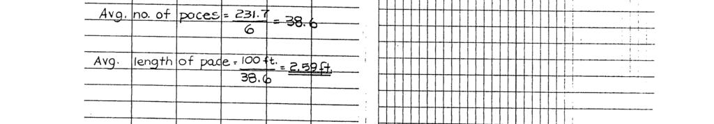
 Surveying Laboratory By: Dr. Ghazi Al-Khateeb Jordan University of Science and Technology Department of Civil Engineering 1. Length of Pace Using Tape and Odometer Length of Pace Using Tape and Odometer
MAHATMA GANDHI MISSION S JAWAHARLAL NEHRU ENGINEERING COLLEGE, AURANGABAD. (M.S.)
") MAHATMA GANDHI MISSION S JAWAHARLAL NEHRU ENGINEERING COLLEGE, AURANGABAD. (M.S.) DEPARTMENT OF CIVIL ENGINEERING SURVEYING - I LAB MANUAL Prof.R.V.Wanjule Lab Incharge Approved By Dr. S. B. Shinde H.O.D.
MAHATMA GANDHI MISSION S JAWAHARLAL NEHRU ENGINEERING COLLEGE, AURANGABAD. (M.S.) DEPARTMENT OF CIVIL ENGINEERING SURVEYING - I LAB MANUAL Prof.R.V.Wanjule Lab Incharge Approved By Dr. S. B. Shinde H.O.D.
1. In chain surveying tie lines are primarily provided a) to check the accuracy of the survey b) to take offsets for detail survey c) to avoid long
 to check the accuracy of the survey b) to take offsets for detail survey c) to avoid long") 1. In chain surveying tie lines are primarily provided a) to check the accuracy of the survey b) to take offsets for detail survey c) to avoid long offsets from chain lines d) to increase the number of
1. In chain surveying tie lines are primarily provided a) to check the accuracy of the survey b) to take offsets for detail survey c) to avoid long offsets from chain lines d) to increase the number of
Pack 12. Surveying processes. Equipment 12.1 Method 12.2 Checklist 12.3 Calculations 12.4
 Pack 1 Surveying processes Equipment 1.1 Method 1. Checklist 1.3 Calculations 1.4 Pack 1 Surveying processes 1.1 Equipment The objective is to measure the height of an inaccessible building using angles.
A New Dimension to Land Development and Subdivision Design: Application of AutoCAD Civil 3D
 A New Dimension to Land Development and Subdivision Design: Application of AutoCAD Civil 3D Tarig Ali College of Engineering and Computer Science University of Central Florida Orlando, Florida taali@mail.ucf.edu
Surveying Prof. Bharat Lohani Indian Institute of Technology, Kanpur. Lecture - 1 Module - 6 Triangulation and Trilateration
 Surveying Prof. Bharat Lohani Indian Institute of Technology, Kanpur Lecture - 1 Module - 6 Triangulation and Trilateration (Refer Slide Time: 00:21) Welcome to this another lecture on basic surveying.
City of La Crosse Online Mapping Website Help Document
 City of La Crosse Online Mapping Website Help Document This document was created to assist in using the new City of La Crosse online mapping sites. When the website is first opened, a map showing the City
ENGI 3703 Surveying and Geomatics
 Angle Measurement: (Chapter 8) We have provided good coverage of distance measurement with total stations. However, our treatment of angle coverage will be light as this is covered adequately in the field
Distance in Coordinate Geometry
 Page 1 of 6 L E S S O N 9.5 We talk too much; we should talk less and draw more. Distance in Coordinate Geometry Viki is standing on the corner of Seventh Street and 8th Avenue, and her brother Scott is
Engineering Geology. Engineering Geology is backbone of civil engineering. Topographic Maps. Eng. Iqbal Marie
 Engineering Geology Engineering Geology is backbone of civil engineering Topographic Maps Eng. Iqbal Marie Maps: are a two dimensional representation, of an area or region. There are many types of maps,
Angles and Directions
 Angles and Directions Angles and Directions Definitions Systems of Angle Measurement Angle Arithmetic Horizontal and Vertical Angles Angle and Direction Measuring Equipment 1 Angle Definitions A measure
Chapter -7- Traversing. 1/28/2018 Assistant Lecturer / Asmaa Abdulmajeed 1. Contents
 Ishik University Sulaimani Civil Engineering Department Surveying II CE 215 Chapter -7- Traversing 1/28/2018 Assistant Lecturer / Asmaa Abdulmajeed 1 Contents 1. Traversing 2. Traversing Computations 3.
CHAPTER 01 Basics of Surveying
 CHAPTER 01 Basics of Surveying 1.1 How do plane surveys and geodetic surveys differ? Plane surveying assumes all horizontal measurements are taken on a single plane and all vertical measurements are relative
Section G. POSITIONAL ACCURACY DEFINITIONS AND PROCEDURES Approved 3/12/02
 Section G POSITIONAL ACCURACY DEFINITIONS AND PROCEDURES Approved 3/12/02 1. INTRODUCTION Modern surveying standards use the concept of positional accuracy instead of error of closure. Although the concepts
CEEN Engineering Measurements Final Exam Fall 2001 Closed Book, Calculator Required 3 Hour Time Limit
 NAME Score CEEN 113-1 Engineering Measurements Final Exam Fall 001 Closed Book, Calculator Required 3 Hour Time Limit 1. (10 pts) You are interested in determining the height of a building. You are unable
UNIVERSITI MALAYSIA SARAWAK FACULTY OF ENGINEERING CIVIL ENGINEERING DEPARTMENT
 UNIVERSITI MALAYSIA SARAWAK FACULTY OF ENGINEERING CIVIL ENGINEERING DEPARTMENT KNS 1461 CIVIL ENGINEERING LABORATORY 2 LABORATORY MANUAL (Edited : December 2008) CIVIL ENGINEERING LABORATORY 2 KNS 1461
ENGI3703- Surveying and Geomatics Fall Closed Traverse
 Objectives: Closed Traverse Learn the principles of running a closed field traverse. Learn how to compute a traverse (by hand or using Excel) and properly adjust the measured values of a closed traverse
Surveying Prof. Bharat Lohani Department of Civil Engineering Indian Institute of Technology, Kanpur
 Surveying Prof. Bharat Lohani Department of Civil Engineering Indian Institute of Technology, Kanpur Module - 6 Lecture - 2 Triangulation and Trilateration Welcome to this another lecture on basic surveying.
Peoria County Front Desk Map Application
 Peoria County Front Desk Map Application Quick Guide, 2017 At a First Glance This guide will tell users all they need to know about the Peoria County Front Desk application which can be found on the Peoria
FACULTY OF CIVIL ENGINEERING & EARTH RESOURCES ENGINEERING SURVEY FIELDWORK. CURVE RANGING COMPUTATION & SETTING-OUT (Standard Of Procedure)
") FACULTY OF CIVIL ENGINEERING & EARTH RESOURCES ENGINEERING SURVEY FIELDWORK CURVE RANGING COMPUTATION & SETTING-OUT (Standard Of Procedure) Subject Code Date Group Number Student Name & ID Number Group
FACULTY OF CIVIL ENGINEERING & EARTH RESOURCES ENGINEERING SURVEY FIELDWORK CURVE RANGING COMPUTATION & SETTING-OUT (Standard Of Procedure) Subject Code Date Group Number Student Name & ID Number Group
Tutorial for Lane County Mapping Applications
 Tutorial for Lane County Mapping Applications Contents Overview... 2 Tools... 2 Navigation Tools... 3 Display Tools... 5 Information Tools... 6 Sharing Tools... 7 Common Tasks... 9 Identify or Show Data
1. Introduction Surveying Method chosen depends on:
 1. Introduction Surveying Method chosen depends on: by the purpose of the survey e.g. map making, location of specific points, definition of land ownership etc., by the nature of the survey itself e.g.
Faculty:-Prof. Mrs. N. Soundarya Semester:-III Class: - C.E. Course Code:-CE -207-F
 Lecture Plan-1 Subject: Surveying-I Unit:- I Fundamental Principals of Surveying Section-A Topic :-Definition, Objects, Classification, Fundamental Principles, Methods of Fixing Stations 1. A brief introduction
Geometry Second Semester Final Exam Review
 Name: Class: Date: ID: A Geometry Second Semester Final Exam Review 1. Find the length of the leg of this right triangle. Give an approximation to 3 decimal places. 2. Find the length of the leg of this
Total station assignment
 Total station assignment Objective: Control survey densification for detail surveying Location: Otaniemi campus, Innopoli 3 park area Equipment: Total Station (or electronic theodolite) and target device
Civil 3D Introduction
 Civil 3D Introduction Points Overview Points are data collected by surveyors which represent existing site conditions (elevations, boundaries, utilities, etc.). Each point is numbered (or named) and has
ANGLES 4/18/2017. Surveying Knowledge FE REVIEW COURSE SPRING /19/2017
 FE REVIEW COURSE SPRING 2017 Surveying 4/19/2017 Surveying Knowledge 4 6 problems Angles, distances, & trigonometry Area computations Earthwork & volume computations Closure Coordinate systems State plane,
Historical Note Trigonometry Ratios via Similarity
 Section 12-6 Trigonometry Ratios via Similarity 1 12-6 Trigonometry Ratios via Similarity h 40 190 ft of elevation Figure 12-83 Measurements of buildings, structures, and some other objects are frequently
General GPS TPS ROB X POLE VOL RDN RPL Jobs management System settings (units, precision, parameters, etc.)
") XPAD Survey Modules XPAD Survey GPS TPS XPOLE General GPS TPS ROB XPOLE VOL RDN RPL Jobs management System settings (units, precision, parameters, etc.) Instruments GPS GPS TPS ROB XPOLE VOL RDN RPL Instrument
XPAD Survey Modules XPAD Survey GPS TPS XPOLE General GPS TPS ROB XPOLE VOL RDN RPL Jobs management System settings (units, precision, parameters, etc.) Instruments GPS GPS TPS ROB XPOLE VOL RDN RPL Instrument
10600 sq. feet. Left 33.8 left of CL at elev Right 33.4 right of CL at elev 871.1
 NAME Score CEEN 113-1 Engineering Measurements Final Exam Fall 1999 Open Book, Closed Note, Calculator Required 3 Hour Time Limit 1 point deduction for every two minutes over 1. (5 pts) Your boss has asked
Technical English -I 5 th week SURVEYING AND MAPPING
 Technical English -I 5 th week SURVEYING AND MAPPING What is surveying? It is the art of defining the positions of natural and man-made made features on the Earth s surface. Basic Tasks and Features in
Name Date Class. When the bases are the same and you multiply, you add exponents. When the bases are the same and you divide, you subtract exponents.
 2-1 Integer Exponents A positive exponent tells you how many times to multiply the base as a factor. A negative exponent tells you how many times to divide by the base. Any number to the 0 power is equal
Geometry Summative Review 2008
 Geometry Summative Review 2008 Page 1 Name: ID: Class: Teacher: Date: Period: This printed test is for review purposes only. 1. ( 1.67% ) Which equation describes a circle centered at (-2,3) and with radius
Math Geometry FAIM 2015 Form 1-A [ ]
![Math Geometry FAIM 2015 Form 1-A [ ]](/thumbs/80/81205175.jpg "Math Geometry FAIM 2015 Form 1-A [ ]") Math Geometry FAIM 2015 Form 1-A [1530458] Student Class Date Instructions Use your Response Document to answer question 13. 1. Given: Trapezoid EFGH with vertices as shown in the diagram below. Trapezoid
Math Geometry FAIM 2015 Form 1-A [1530458] Student Class Date Instructions Use your Response Document to answer question 13. 1. Given: Trapezoid EFGH with vertices as shown in the diagram below. Trapezoid
GSN SunShot Procedures Using Internet Solar Position Calculator
 GSN SunShot Procedures Using Internet Solar Position Calculator Purpose: Determine astronomical (true) north for instrument orientation by observing the Sun s azimuth using a Theodolite and Sun Position
We can use square dot paper to draw each view (top, front, and sides) of the three dimensional objects:
 of the three dimensional objects:") Unit Eight Geometry Name: 8.1 Sketching Views of Objects When a photo of an object is not available, the object may be drawn on triangular dot paper. This is called isometric paper. Isometric means equal
Unit Eight Geometry Name: 8.1 Sketching Views of Objects When a photo of an object is not available, the object may be drawn on triangular dot paper. This is called isometric paper. Isometric means equal
Alignment with the Wild T1A theodolite
 Alignment with the Wild T1A theodolite Author: Nigel Warr Date: 25 th March 2012. Contents 1 Overview 2 2 Setting up the tripod 2 3 The scales 5 4 Aligning the height 6 1 1 Overview Figure 1: The Wild
0116geo. Geometry CCSS Regents Exam William is drawing pictures of cross sections of the right circular cone below.
 0116geo 1 William is drawing pictures of cross sections of the right circular cone below. 3 In parallelogram QRST shown below, diagonal is drawn, U and V are points on and, respectively, and intersects
1. Which diagram best represents the location of the isolines for the elevation field of this landscape? (1) (2) (3) (4)
 (2) (3) (4)") Base your answers to questions 1 through 5 on your knowledge of earth science and on the diagram below which represents the elevation data for a certain landscape region. Points A, B, C, and D are specific
Base your answers to questions 1 through 5 on your knowledge of earth science and on the diagram below which represents the elevation data for a certain landscape region. Points A, B, C, and D are specific
SHORT SHARP MANUALS. BIM for Landscape. archoncad.com Making Vectorworks easy!
 SHORT SHARP MANUALS BIM for Landscape archoncad.com Making Vectorworks easy! http://learn.archoncad.com 2015 Jonathan Pickup - Archoncad All rights reserved. No part of this book may be reproduced or transmitted
CE 103. Surveying. Course Instructor. Shayok Ghosh. Senior Lecturer Department of Civil Engineering East West University.
 CE 103 Surveying Course Instructor Shayok Ghosh Senior Lecturer Department of Civil Engineering East West University Shayok Ghosh 1 CHAPTER SEVEN TRAVERSE SURVEY 7.1 Definition Traversing is a type of
EL DORADO COUNTY SURVEYOR FEE SCHEDULE FOR SERVICES
 NOTE ON FEES: Where no fee exists to cover an application process or service, or when the circumstances of the application or service are unique, the fee may be based on a similar category, an estimate
ANOOP BANWALA LECT. IN CIVIL ENGINEERING GGSGP CHEEKA
 ANOOP BANWALA LECT. IN CIVIL ENGINEERING GGSGP CHEEKA 1 So far we have been measuring horizontal angles by using a Compass with respect to meridian, which is less accurate and also it is not possible to
AWM 11 UNIT 4 TRIGONOMETRY OF RIGHT TRIANGLES
 AWM 11 UNIT 4 TRIGONOMETRY OF RIGHT TRIANGLES Assignment Title Work to complete Complete 1 Triangles Labelling Triangles 2 Pythagorean Theorem Exploring Pythagorean Theorem 3 More Pythagorean Theorem Using
Instructors Manual. for. Construction Surveying and Layout. Third Edition. Part Two - Officework and Calculations. Chapters
 Instructors Manual for Construction Surveying and Layout Third Edition Part Two - Officework and Calculations Chapters 11-18 Prepared by Wesley G. Crawford TABLE OF CONTENTS Chapter 11 - Officework Practices...
Class Objectives CE 211 SURVEYING ENGINEERING CLASS 09: LEVELING (3) 9/12/2011 VERTICAL CONTROL (BENCHMARK) SURVEYS
 9/12/2011 VERTICAL CONTROL (BENCHMARK) SURVEYS") CE 211 SURVEYING ENGINEERING CLASS 09: LEVELING (3) Ahmed Abdel-Rahim, Ph.D, P.E. Associate Professor, Civil Engineering Class Objectives Identify benchmark leveling procedures Develop field notes for
CE 211 SURVEYING ENGINEERING CLASS 09: LEVELING (3) Ahmed Abdel-Rahim, Ph.D, P.E. Associate Professor, Civil Engineering Class Objectives Identify benchmark leveling procedures Develop field notes for
CE 220 LABORATORY MANUAL 2002 InRoads 8.3
 CE 220 LABORATORY MANUAL 2002 InRoads 8.3 INSTRUCTOR DR. HOWARD TURNER P.L.S. MAPPING SCIENCES CENTER OF EXCELLENCE CALIFORNIA STATE POLYTECHNIC UNIVERSITY, POMONA 3801 W. TEMPLE AVENUE POMONA CA 91768
SURVEYING-II(5 TH CIVIL) CHAPTER-1 Name of the Chapter - Leveling
 CHAPTER-1 Name of the Chapter - Leveling") SURVEYING-II(5 TH CIVIL) CHAPTER-1 Name of the Chapter - Leveling 1. Define parallax. [2012] The apparent movement of image relative to the cross hair is known as parallax. This occurs due to imperfect
SURVEYING-II(5 TH CIVIL) CHAPTER-1 Name of the Chapter - Leveling 1. Define parallax. [2012] The apparent movement of image relative to the cross hair is known as parallax. This occurs due to imperfect
ENGINEERING SURVEYING (221 BE)
") ENGINEERING SURVEYING (221 BE) Horizontal Circular Curves Sr Tan Liat Choon Email: tanliatchoon@gmail.com Mobile: 016-4975551 INTRODUCTION The centre line of road consists of series of straight lines interconnected
ENGINEERING SURVEYING (221 BE) Horizontal Circular Curves Sr Tan Liat Choon Email: tanliatchoon@gmail.com Mobile: 016-4975551 INTRODUCTION The centre line of road consists of series of straight lines interconnected
Level 6 Graduate Diploma in Engineering Engineering surveying
 9210-104 Level 6 Graduate Diploma in Engineering Engineering surveying Sample Paper You should have the following for this examination answer booklets non-programmable calculator pens, pencils, drawing
Trimble. S6 Total Station. Demonstration Guide
 Trimble S6 Total Station Demonstration Guide Version 1.00 Revision A Part Number 022543-106 January 2005 Contact Information Trimble Geomatics and Engineering Division 5475 Kellenburger Road Dayton, Ohio
Pre-Algebra HS Semester 2 Practice Exam B
 1. A right triangle is shown below. 5 What is the value of x? 1 17 4 169 12 x Figure is not drawn to scale. 4. Which of the following measurements represent a right triangle? I., 4, 5 II. 5, 12, 1 III.
Topic 3: Angle measurement traversing
 Topic 3: Angle measurement traversing Aims -Learn what control surveys are and why these are an essential part of surveying -Understand rectangular and polar co-ordinates and how to transform between the
Find sin R and sin S. Then find cos R and cos S. Write each answer as a fraction and as a decimal. Round to four decimal places, if necessary.
 Name Homework Packet 7.6 7.7 LESSON 7.6 For use with pages 473-480 AND LESSON 7.7 For use with pages 483 489 Find sin R and sin S. Then find cos R and cos S. Write each answer as a fraction and as a decimal.
GUDLAVALLERU ENGINEERING COLLEGE SESHADRI RAO KNOWLEDGE VILLAGE: GUDLAVALLERU DEPARTMENT OF CIVIL ENGINEERING
 SURVEYING FIELD WORK II LABORATORY Name Regd. No : :. Year & Semester :.. Academic Year :. GUDLAVALLERU ENGINEERING COLLEGE SESHADRI RAO KNOWLEDGE VILLAGE: GUDLAVALLERU DEPARTMENT OF CIVIL ENGINEERING
CCGPS End of Course Diagnostic Test
 CCGPS End of Course Diagnostic Test Revised 12/29/13 1:19 pm 1. is a dilation of triangle by a scale factor of ½. The dilation is centered at the point ( 5, 5). Which statement below is true? 2. is a dilation
PARCC Geometry Practice Test Released April,
 Non-Calculator Part 1. The figure shows with side lengths as indicated. Enter your answer in the box. 2. The figure shows two perpendicular lines s and r intersecting at point P in the interior of a trapezoid.
Leica DISTO X3 Designed for tough, rugged conditions
 Leica DISTO X3 Designed for tough, rugged conditions The rugged Leica DISTO X-series combines innovative measuring technologies with a site-proof design and simple user interface. Together with the Leica
GLOBAL EDITION. Elementary Surveying. An Introduction to Geomatics FOURTEENTH EDITION. Charles D. Ghilani Paul R. Wolf
 GLOBAL EDITION Elementary Surveying An Introduction to Geomatics FOURTEENTH EDITION Charles D. Ghilani Paul R. Wolf Vice President and Editorial Director, ECS: Marcia Horton Executive Editor: Holly Stark
MAHARASHTRA STATE BOARD OF TECHNICAL EDUCATION (Autonomous) (ISO/IEC Certified)
 (ISO/IEC Certified)") WINTER 17 EXAMINATION Subject Name: Advanced Surveying Model Answer Subject Code: 17419 Important Instructions to examiners: 1) The answers should be examined by key words and not as word-to-word as given
WINTER 17 EXAMINATION Subject Name: Advanced Surveying Model Answer Subject Code: 17419 Important Instructions to examiners: 1) The answers should be examined by key words and not as word-to-word as given
Semester Exam Review. Honors Geometry A
 Honors Geometry 2015-2016 The following formulas will be provided in the student examination booklet. Pythagorean Theorem In right triangle with right angle at point : 2 2 2 a b c b c a Trigonometry In
Acute Angles and Right Triangles. Copyright 2017, 2013, 2009 Pearson Education, Inc.
 2 Acute Angles and Right Triangles Copyright 2017, 2013, 2009 Pearson Education, Inc. 1 2.5 Further Applications of Right Triangles Historical Background Bearing Further Applications Copyright 2017, 2013,
Please print twice and give one to a friend. Here is an example of the Deed Plotter and All Topo Maps working together.
 JOHNSON MAPPING SOFTWARE & PLOTTING SEMINARS Mike Johnson, Seminar Author & Instructor, also Dealer for: Deed Plotter+for Windows (by Greenbrier Graphics)& the All Topo Maps (by igage Mapping Co.) Computer
Unit 6: Triangle Geometry
 Unit 6: Triangle Geometry Student Tracking Sheet Math 9 Principles Name: lock: What I can do for this unit: fter Practice fter Review How I id 6-1 I can recognize similar triangles using the ngle Test,
Land Development Suite for BricsCAD Manual: Survey and Cogo commands:
 Land Development Suite for BricsCAD Manual: Survey and Cogo commands: Before you begin go to Drafting -- Drawing Setup Drawing Setup - Select English or Metric units -changes the ltscale and labeling precision,
G.8 Right Triangles STUDY GUIDE
 G.8 Right Triangles STUDY GUIDE Name Date Block Chapter 7 Right Triangles Review and Study Guide Things to Know (use your notes, homework, quizzes, textbook as well as flashcards at quizlet.com (http://quizlet.com/4216735/geometry-chapter-7-right-triangles-flashcardsflash-cards/)).
First-Time Setup. Summary Steps CHAPTER
 CHAPTER 4 Revised: May 9, 2012, This chapter describes the steps you take to configure the CTS 1300 to use it for the first time and includes the following sections: Required Tools and Accessories, page
Lesson 1: Slope and Distance
 Common Core Georgia Performance Standards MCC8.G.8* (Transition Standard 01 013; asterisks denote Transition Standards) MCC9 1.G.GPE.4 MCC9 1.G.GPE.5 Essential Questions 1. How is the Pythagorean Theorem
1 William is drawing pictures of cross sections of the right circular cone below.
 1 William is drawing pictures of cross sections of the right circular cone below. Which drawing can not be a cross section of a cone? 1) 2) 3) 4) 2 An equation of a line perpendicular to the line represented
Leica FlexField plus & Leica FlexOffice A Perfect Match
 Leica FlexField & Leica FlexOffice A Perfect Match FlexField Onboard Software General File Management Data Import Data Export Status icon bar Instrument Protection with PIN Stake Out beep Map Select Programs
ADVANCED SURVEYING (S-II)
") ADVANCED SURVEYING (S-II) (LAB) KISHANGANJ COLLEGE OF ENGINEERING AND TECHNOLOGY, KISHANGANJ. Experiment No- 1 ADVANCED SURVEYING (S-II) LAB Aim: Determination of the Multiplying and additive constant
ADVANCED SURVEYING (S-II) (LAB) KISHANGANJ COLLEGE OF ENGINEERING AND TECHNOLOGY, KISHANGANJ. Experiment No- 1 ADVANCED SURVEYING (S-II) LAB Aim: Determination of the Multiplying and additive constant
FINAL Examination Paper (COVER PAGE) Time : 8.00 am am Reading Time : 10 Minutes
 Time : 8.00 am am Reading Time : 10 Minutes") Session : August 2013 FINAL Examination Paper (COVER PAGE) Programme : Diploma in Civil Engineering Course : EGC2170 : Surveying 2 Date of Examination : December 09, 2013 Time : 8.00 am 10.10 am Reading
Session : August 2013 FINAL Examination Paper (COVER PAGE) Programme : Diploma in Civil Engineering Course : EGC2170 : Surveying 2 Date of Examination : December 09, 2013 Time : 8.00 am 10.10 am Reading
AutoCAD Civil 3D 2014 for Surveyors
 AutoCAD Civil 3D 2014 for Surveyors SDC P U B L I C AT I O N S Better Textbooks. Lower Prices. www.sdcpublications.com Powered by TCPDF (www.tcpdf.org) Visit the following websites to learn more about
Lesson 1. Unit 2 Practice Problems. Problem 2. Problem 1. Solution 1, 4, 5. Solution. Problem 3
 Unit 2 Practice Problems Lesson 1 Problem 1 Rectangle measures 12 cm by 3 cm. Rectangle is a scaled copy of Rectangle. Select all of the measurement pairs that could be the dimensions of Rectangle. 1.
1. PRECAUTIONS. Thank you for choosing RUIDE theodolite Disteo 23. Please read this manual carefully before use.
 Thank you for choosing RUIDE theodolite Disteo 23. Please read this manual carefully before use. 1. PRECAUTIONS a. Do not collimate the objective lens directly to the sunlight without a filter. b. Do not
QUAD 1000 OWNERS MANUAL OPERATION GUIDE
 QUAD 1000 OWNERS MANUAL OPERATION GUIDE Built in Redmond Oregon USA COMPONENTS 4001-0000 Quad 1000 5 arc second zenith laser featuring electronic servo self-leveling with variable temperature compensation
SURPAC Surveying Software Version 5.65 for Windows XP/Vista/7/8/10
 SURPAC Surveying Software Version 5.65 for Windows XP/Vista/7/8/10 Topographical, Engineering, Mining and Cadastral Surveying Applications Topographical, Engineering, Mining and Cadastral Surveying Applications
Indirect Measurement Application of Similar Triangles. Identify similar triangles to calculate. indirect measurement
 Indirect Measurement Application of Similar Triangles. LEARNING GOALS In this lesson, you will: Identify similar triangles to calculate indirect measurements. Use proportions to solve for unknown measurements.
Leica DISTO X4 Designed for bright, outdoor environments
 Leica DISTO X4 Designed for bright, outdoor environments Pointfinder camera The DISTO X4 is equipped with a Pointfinder camera allowing you to easily target distant objects in bright sunlight. Even if
S P. Geometry Final Exam Review. Name R S P Q P S. Chapter 7 1. If you reflect the point (2, -6) in the x-axis, the coordinates of the image would be:
 in the x-axis, the coordinates of the image would be:") Geometry Final Exam Review Chapter 7 1. If you reflect the point (2, -6) in the x-axis, the coordinates of the image would be: Name 6. Use the graph below to complete the sentence. 2. If you reflect the
Geometry Final Exam Review Chapter 7 1. If you reflect the point (2, -6) in the x-axis, the coordinates of the image would be: Name 6. Use the graph below to complete the sentence. 2. If you reflect the
Grading and Volumes CHAPTER INTRODUCTION OBJECTIVES
 CHAPTER 10 Grading and Volumes INTRODUCTION AutoCAD Civil 3D uses surface breaklines, cogo points, contours, feature lines, and grading objects to create a surface design. There are numerous ways to grade
2. Find the distance between points P(7, 4) and Q(1, 2) to the nearest tenth.
 and Q(1, 2) to the nearest tenth.") Permitted resources: 2016 2017 Geometry Midterm Review FSA Approved calculator Geometry FSA Reference Sheet 1. Rectangle ABCD is shown below. Find the midpoint of diagonal AC. 2. Find the distance between
Permitted resources: 2016 2017 Geometry Midterm Review FSA Approved calculator Geometry FSA Reference Sheet 1. Rectangle ABCD is shown below. Find the midpoint of diagonal AC. 2. Find the distance between
General Certificate of Secondary Education Higher Tier November Time allowed 1 hour 30 minutes
 Centre Number Surname Candidate Number For Examiner s Use Other Names Candidate Signature Examiner s Initials Pages Mark Mathematics General Certificate of Secondary Education Higher Tier November 2014
P&D GIS Map How-To-Guide Thomas Fire / January 9, 2018 Debris Flow
 P&D GIS Map How-To-Guide The interactive GIS web-based map is available here. Once you have accessed the map, type in your address in the field on the top right corner and click on the magnifying glass
Unit 1 Trigonometry. Topics and Assignments. General Outcome: Develop spatial sense and proportional reasoning. Specific Outcomes:
 1 Unit 1 Trigonometry General Outcome: Develop spatial sense and proportional reasoning. Specific Outcomes: 1.1 Develop and apply the primary trigonometric ratios (sine, cosine, tangent) to solve problems
Government of Karnataka Department of Technical Education Board of Technical Examinations, Bangalore Course Title: SURVEYING PRACTICE - II
 Government of Karnataka Department of Technical Education Board of Technical Examinations, Bangalore Course Title: SURVEYING PRACTICE - II Credits (L:T:P) : 0:2:4 Total Contact Hours: 78 Course Code: 15CE6P
1. One-third of 105 is the same as seven-sixths of what number? 1.
 Blitz, Page. One-third of 05 is the same as seven-sixths of what number?. 2. A rectangle has length 6 and width 2. What is the radius of the 2. units circle that passes through the four vertices of the
Right Triangles CHAPTER. 3.3 Drafting Equipment Properties of 45º 45º 90º Triangles p. 189
 CHAPTER Right Triangles Hiking is the most popular outdoor activity in the United States, with almost 40% of Americans hiking every year. Hikers should track their location and movements on a map so they