Image georeferencing is the process of developing a model to transform from pixel coordinates into GIS coordinates such as meters on the ground.
|
|
|
- Phebe Byrd
- 5 years ago
- Views:
Transcription
1 Image georeferencing is the process of developing a model to transform from pixel coordinates into GIS coordinates such as meters on the ground. Image rectification is the process of using your georeferencing model to output to a new raster in your GIS coordinates. 1
2 Notice there is a positive correlation between the pixel X and Map X while there is a negative correlation between the pixel Y (row direction) and the map Y (typically increasing to the north). 2
3 The affine transformtion is a typical georeferencing model. It works well for conditions that approximate a flat plane..aerial photography from a floodplain, a scanned map that had been corrected for topography, or satellite imagery. 3

4 Note that the coefficients C,F are translation for the center of the pixel from the first row, first column. A and E are scaling coefficients for X, Y and are typically the same value. 4
5 Scaling essentially assigns the proper pixel size to the rectified image in meters on the ground. 5
6 The rectification model can move the raster to a new map coordinate location. 6
7 The rectification model can rotate an image. A typical example of rotation is with a scanned aerial photograph or a satellite image where north is not straight up on the original raster. After rotation, the Y axis of the raster is correctly oriented up and down. 7
8 The world file contains the model coefficients for translation, scaling and rotation. 8

9 Here is an example you could duplicate. Start by creating a text file and then use the AscII to Raster tool to create a raster image. 9
10 10

11 You must specify that you want to use text world file since the georeferencing model is typically written to the aux.xml file instead of a simple world file 11
12 By creating a world file, you create the rectification model that Arcmap will use on the fly when you add the raster to your arcmap data frame. 12

13 In this example, the X,Y scaling coefficients change from 25 to 100 meters, so the pixels in testcopy.tif are 4 X larger than those in test.tif in width and length. 13

14 Notice Arcmap moves the image based on the translation coefficients in the world file X translation was originally zero, so move to the right +10 meters, Y translation was originally 225, so move down 25 meters. 14

15 In this example, the pixel x,y scaling is 20 meters, the image is moved via the translation coefficients, and rotated via the +5,-5 rotation coefficients. 15
16 The georeferencing model puts the raster as 25-meter pixels with UTM coordinates of 500,000m =X 7,181,000 m =Y at center of upper left pixel. 16

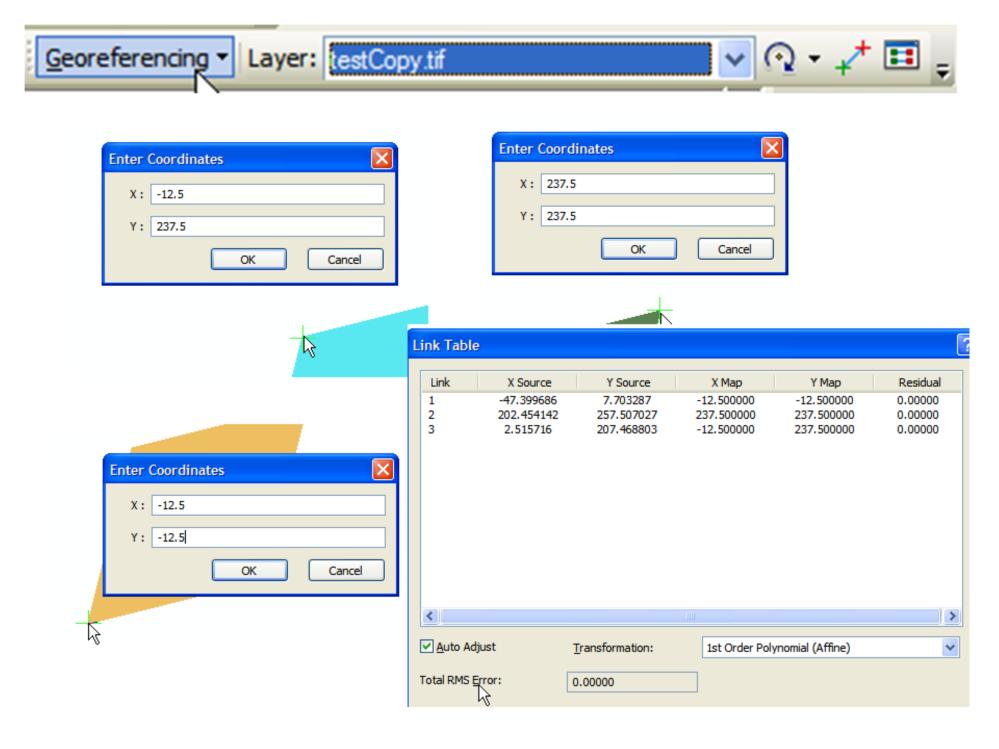
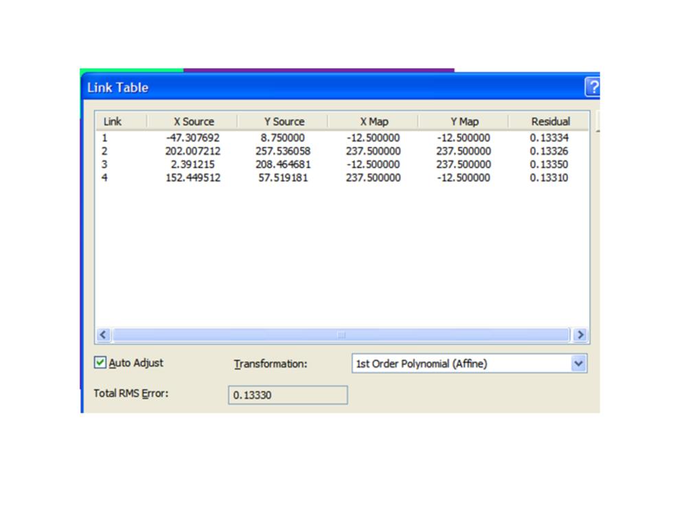
17 To develop the rectification model, you supply links. Links are the original image X,Y coordinates and the map (projected coordinate system) coordinates for the same locations. You supply the image X,Y coordinates with your mouse cursor located somewhere on the original raster image. You then supply the associated map coordinates either by entering the map coordinate values or by pointing to a GIS feature that is in that map coordinate system. 17
18 18
19 19
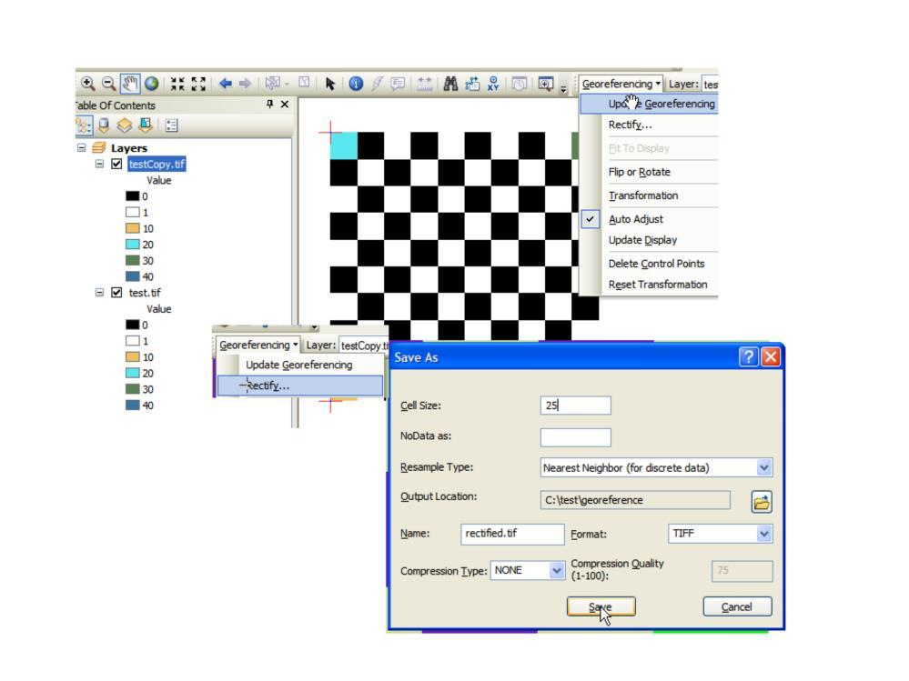
20 20
 while the second raster is in UTM coordinates.")
21 Here is an example. The first raster is in pixel coordinates (rows, cols) while the second raster is in UTM coordinates. We want to transform the first image so it is in the UTM coordinate system. 21

22 Find discrete locations that both images have in common to develop the links. 22

23 With a couple of links, the auto adjust develops a georeferencing modes and it is used in the display so then your job will be easier as the images approach good spatial co-registration. 23
. You can always fit a plane through 3 points, so you will always have an artificial RMS error of 0 with 3 links.")
24 The link table shows you re the overall error of your rectification model as well as the error from each link (how far each link is from the model s predicted location for that link). You can always fit a plane through 3 points, so you will always have an artificial RMS error of 0 with 3 links. 24
25 Here is one link error the distance between the actual UTM coordinate of a link and its UTM coordinate as predicted from the rectification model. 25
 then the two photos are spatially aligned.")
26 When the model RMS error is acceptable (less than one-pixel) then the two photos are spatially aligned. 26

27 Update georeferencing stores the model and is applied whenever you add the raster in Arcmap. Rectify uses the model to output to a new georeferenced raster. 27
Georeferencing in ArcGIS
 Georeferencing in ArcGIS Georeferencing In order to position images on the surface of the earth, they need to be georeferenced. Images are georeferenced by linking unreferenced features in the image with
Blacksburg, VA July 24 th 30 th, 2010 Georeferencing images and scanned maps Page 1. Georeference
 George McLeod Prepared by: With support from: NSF DUE-0903270 in partnership with: Geospatial Technician Education Through Virginia s Community Colleges (GTEVCC) Georeference The process of defining how
Geometric Rectification of Remote Sensing Images
 Geometric Rectification of Remote Sensing Images Airborne TerrestriaL Applications Sensor (ATLAS) Nine flight paths were recorded over the city of Providence. 1 True color ATLAS image (bands 4, 2, 1 in
Lab 5: Georeferencing, Digitization, and Processing
 Lab 5: Georeferencing, Digitization, and Processing Purpose: An introduction to georeferencing images, practice digitizing, and combine lesson up to this point. To Do: Register a scanned image, digitize
Georeferencing & Spatial Adjustment
 Georeferencing & Spatial Adjustment Aligning Raster and Vector Data to the Real World Rotation Differential Scaling Distortion Skew Translation 1 The Problem How are geographically unregistered data, either
Geoprocessing and georeferencing raster data
 Geoprocessing and georeferencing raster data Raster conversion tools Geoprocessing tools ArcCatalog tools ESRI Grid GDB Raster Raster Dataset Raster Catalog Erdas IMAGINE TIFF ArcMap - raster projection
Georeferencing & Spatial Adjustment 2/13/2018
 Georeferencing & Spatial Adjustment The Problem Aligning Raster and Vector Data to the Real World How are geographically unregistered data, either raster or vector, made to align with data that exist in
The Problem. Georeferencing & Spatial Adjustment. Nature Of The Problem: For Example: Georeferencing & Spatial Adjustment 9/20/2016
 Georeferencing & Spatial Adjustment Aligning Raster and Vector Data to the Real World The Problem How are geographically unregistered data, either raster or vector, made to align with data that exist in
Overview. Image Geometric Correction. LA502 Special Studies Remote Sensing. Why Geometric Correction?
 LA502 Special Studies Remote Sensing Image Geometric Correction Department of Landscape Architecture Faculty of Environmental Design King AbdulAziz University Room 103 Overview Image rectification Geometric
Georeferencing Imagery in ArcGIS 10.3.x
 Georeferencing Imagery in ArcGIS 10.3.x Georeferencing is the process of aligning imagery (maps, air photos, etc.) with spatial data such as point, lines or polygons (for example, roads and water bodies).
COORDINATE TRANSFORMATION. Lecture 6
 COORDINATE TRANSFORMATION Lecture 6 SGU 1053 SURVEY COMPUTATION 1 Introduction Geomatic professional are mostly confronted in their work with transformations from one two/three-dimensional coordinate system
The Problem. Georeferencing & Spatial Adjustment. Nature of the problem: For Example: Georeferencing & Spatial Adjustment 2/4/2014
 Georeferencing & Spatial Adjustment Aligning Raster and Vector Data to a GIS The Problem How are geographically unregistered data, either raster or vector, made to align with data that exist in geographical
How to georeference images in ArcMap (Arcinfo, ArcReader, ArcView)
") How to georeference images in ArcMap (Arcinfo, ArcReader, ArcView) This procedure outlines the steps required to georeference any image, including air photos or raster copies of scanned paper maps. In
How to georeference images in ArcMap (Arcinfo, ArcReader, ArcView) This procedure outlines the steps required to georeference any image, including air photos or raster copies of scanned paper maps. In
GIS data input. In the early days of GIS 1980s and early 1990s. We used canned datasets for teaching (from USA)
") GIS data input GIS is the automated : acquisition - input management analysis display of spatial data In the early days of GIS 1980s and early 1990s There were no or little GIS data We used canned datasets
GIS data input GIS is the automated : acquisition - input management analysis display of spatial data In the early days of GIS 1980s and early 1990s There were no or little GIS data We used canned datasets
Training i Course Remote Sensing Basic Theory & Image Processing Methods September 2011
 Training i Course Remote Sensing Basic Theory & Image Processing Methods 19 23 September 2011 Geometric Operations Michiel Damen (September 2011) damen@itc.nl ITC FACULTY OF GEO-INFORMATION SCIENCE AND
RDSC Workshop #4 Finding, Organizing & Creating Data. Sarah Watson March 17, 2017
 RDSC Workshop #4 Finding, Organizing & Creating Data Sarah Watson March 17, 2017 Overview Briefly discuss different online data sets Adjust the Scanned Map in Photoshop Georeference Scanned Map in ArcMap
Lab 6: Transforming Spatial Data
 Lab 6: Transforming Spatial Data Objectives: The primary objectives of this lab are to georeference a raster dataset and to create GIS data by digitizing features from an image as a backdrop. Specifics:
Low-Cost Orthophoto Production Using OrthoMapper Software
 Low-Cost Orthophoto Production Using OrthoMapper Software Rick Day Penn State Cooperative Extension, Geospatial Technology Program, RGIS-Chesapeake Air Photos Historical air photos are available from a
Introducing ArcScan for ArcGIS
 Introducing ArcScan for ArcGIS An ESRI White Paper August 2003 ESRI 380 New York St., Redlands, CA 92373-8100, USA TEL 909-793-2853 FAX 909-793-5953 E-MAIL info@esri.com WEB www.esri.com Copyright 2003
Lecture 4. Image Georeferencing, Accuracy and Precision, File Geodatabase
 Lecture 4 Image Georeferencing, Accuracy and Precision, File Geodatabase Tomislav Sapic GIS Technologist Faculty of Natural Resources Management Lakehead University Why Georeference? Images of the surface
Aerial Photo Rectification
 Aerial Photo Rectification ERDAS Imagine 2016 Description: We will be using ERDAS Imagine to georeference aerial photos to a DOQ image. We will try to achieve this with a total RMS (root mean square) error
Chapters 1-4: Summary
 Chapters 1-4: Summary So far, we have been investigating the image acquisition process. Chapter 1: General introduction Chapter 2: Radiation source and properties Chapter 3: Radiation interaction with
Topic 5: Raster and Vector Data Models
 Geography 38/42:286 GIS 1 Topic 5: Raster and Vector Data Models Chapters 3 & 4: Chang (Chapter 4: DeMers) 1 The Nature of Geographic Data Most features or phenomena occur as either: discrete entities
Lecture 06. Raster and Vector Data Models. Part (1) Common Data Models. Raster. Vector. Points. Points. ( x,y ) Area. Area Line.
 Common Data Models. Raster. Vector. Points. Points. ( x,y ) Area. Area Line.") Lecture 06 Raster and Vector Data Models Part (1) 1 Common Data Models Vector Raster Y Points Points ( x,y ) Line Area Line Area 2 X 1 3 Raster uses a grid cell structure Vector is more like a drawn map
Lecture 06 Raster and Vector Data Models Part (1) 1 Common Data Models Vector Raster Y Points Points ( x,y ) Line Area Line Area 2 X 1 3 Raster uses a grid cell structure Vector is more like a drawn map
Remote Sensing in an
 Chapter 2: Adding Data to a Map Document Remote Sensing in an ArcMap Environment Remote Sensing Analysis in an ArcMap Environment Tammy E. Parece Image source: landsat.usgs.gov Tammy Parece James Campbell
Terrain correction. Backward geocoding. Terrain correction and ortho-rectification. Why geometric terrain correction? Rüdiger Gens
 Terrain correction and ortho-rectification Terrain correction Rüdiger Gens Why geometric terrain correction? Backward geocoding remove effects of side looking geometry of SAR images necessary step to allow
Lecture 7 Digitizing. Dr. Zhang Spring, 2017
 Lecture 7 Digitizing Dr. Zhang Spring, 2017 Model of the course Using and making maps Navigating GIS maps Map design Working with spatial data Geoprocessing Spatial data infrastructure Digitizing File
Midterm Examination CS 534: Computational Photography
 Midterm Examination CS 534: Computational Photography November 3, 2016 NAME: Problem Score Max Score 1 6 2 8 3 9 4 12 5 4 6 13 7 7 8 6 9 9 10 6 11 14 12 6 Total 100 1 of 8 1. [6] (a) [3] What camera setting(s)
Lab#6: Editing Shapefiles With ArcMap. create a point layer from a text file, then join a table to your point attribute table
 NRM338 Fall 2018 Lab#6 Page#1 of 17 In this lab, you will Lab#6: Editing Shapefiles With ArcMap create a point layer from a text file, then join a table to your point attribute table create hyperlinks
Geometric Correction of Imagery
 Geometric Correction of Imagery Geometric Correction of Imagery Present by: Dr.Weerakaset Suanpaga D.Eng(RS&GIS) The intent is to compensate for the distortions introduced by a variety of factors, so that
How to Align a Non- Georeferenced Image to an Existing Geographic Layer or Georeferenced Image
 How to Align a Non- Georeferenced Image to an Existing Geographic Layer or Georeferenced Image Written by Barbara M. Parmenter, revised 14 October 2011 You can align, or georeference, scanned maps to existing
CORRECTING RS SYSTEM DETECTOR ERROR GEOMETRIC CORRECTION
 1 CORRECTING RS SYSTEM DETECTOR ERROR GEOMETRIC CORRECTION Lecture 1 Correcting Remote Sensing 2 System Detector Error Ideally, the radiance recorded by a remote sensing system in various bands is an accurate
3D Terrain Modelling of the Amyntaio Ptolemais Basin
 2nd International Workshop in Geoenvironment and 1 3D Terrain Modelling of the Amyntaio Ptolemais Basin G. Argyris, I. Kapageridis and A. Triantafyllou Department of Geotechnology and Environmental Engineering,
ANNEX V RASTER TO VECTOR CONVERSION MANUAL
 ANNEX V RASTER TO VECTOR CONVERSION MANUAL Table of Contents 1. Introduction...1 2. Software used...1 3. Methodology Flow chart...1 4. Scanning hard copy map...1 5. Working with Photo-editor environment
University of Technology Building & Construction Department / Remote Sensing & GIS lecture
 5. Corrections 5.1 Introduction 5.2 Radiometric Correction 5.3 Geometric corrections 5.3.1 Systematic distortions 5.3.2 Nonsystematic distortions 5.4 Image Rectification 5.5 Ground Control Points (GCPs)
Map Compilation CHAPTER HISTORY
 CHAPTER 7 Map Compilation 7.1 HISTORY Producing accurate commercial maps from aerial photography began in the 1930s. The technology of stereomapping over the last 70 years has brought vast technological
GPS What is it? Combination of: Orbiting satellites
 Chart Your Course: Guidelines for GPS Mapping Dave Ragan Ragan Technical Solutions, Inc. www.ragantechnical.com GPS What is it? Combination of: Orbiting satellites GPS What is it? Orbiting satellites Combination
Objectives Learn how free online map data can quickly and easily be used to dynamically update background maps and aerial photography in GMS.
 v. 10.1 GMS 10.1 Tutorial Using free, dynamic, online map data in GMS Objectives Learn how free online map data can quickly and easily be used to dynamically update background maps and aerial photography
START>PROGRAMS>ARCGIS>
 Department of Urban Studies and Planning Spring 2006 Department of Architecture Site and Urban Systems Planning 11.304J / 4.255J GIS EXERCISE 2 Objectives: To generate the following maps using ArcGIS Software:
4.0 DIGITIZATION, EDITING AND STRUCTURING OF MAP DATA
 .0 DIGITIZATION, EDITING AND STRUCTURING OF MAP DATA The process of digitizing existing maps is a transformation from one analog) form of information to another digital) form. Data input is the operation
Spatial data and QGIS
 Spatial data and QGIS Xue Jingbo IT Center 2017.08.07 A GIS consists of: Spatial Data. Computer Hardware. Computer Software. Longitude Latitude Disease Date 26.870436-31.909519 Mumps 13/12/2008 26.868682-31.909259
Easy way to making a photo-realistic Condor scenery
 Easy way to making a photo-realistic Condor scenery by Luis Briones Introduction First at all, sorry for my English. This not pretend be an original work. It's only a way that I can make a scenery. I had
٥...: (Picture element) Pixel ٧...:
 Pixel ٧...:") ( RS ) : : / : : - ٣... : ٣...: ٤...: ٥...: (Picture element) Pixel ٥...: ٧...: ١٠... : Geo Tiff ١٨... : ١٩... : DEM ٢٨...: ٢ :.. " " RS. :.. Kosmos Land Sat. : : RS :. : (Land Use) :( Change detection
( RS ) : : / : : - ٣... : ٣...: ٤...: ٥...: (Picture element) Pixel ٥...: ٧...: ١٠... : Geo Tiff ١٨... : ١٩... : DEM ٢٨...: ٢ :.. " " RS. :.. Kosmos Land Sat. : : RS :. : (Land Use) :( Change detection
GY461 GIS 1: Environmental Campus Topography Project with ArcGIS 9.x
 I. Introduction GY461 GIS 1: Environmental In this project you will use data from a topographic survey of the USA campus to generate 2 separate maps: 1. A color-coded 2-dimensional topographic contour
Reset Cursor Tool Clicking on the Reset Cursor tool will clear all map and tool selections and allow tooltips to be displayed.
 SMS Featured Icons: Mapping Toolbar This document includes a brief description of some of the most commonly used tools in the SMS Desktop Software map window toolbar as well as shows you the toolbar shortcuts
2) Make sure that the georeferencing extension is on by right-clicking in the task bar area and selecting Georeferencing
 Make sure that the georeferencing extension is on by right-clicking in the task bar area and selecting Georeferencing") HGIS Workshop Module 1 Georeferencing Large Scale Scanned Historical Maps Objective: Learn the Principles of Georeferencing 1) In ArcMap, open the project 01 data\arcdata_10_1\arcdata\toronto\georeference.mxd
HGIS Workshop Module 1 Georeferencing Large Scale Scanned Historical Maps Objective: Learn the Principles of Georeferencing 1) In ArcMap, open the project 01 data\arcdata_10_1\arcdata\toronto\georeference.mxd
v Working with Rasters SMS 12.1 Tutorial Requirements Raster Module Map Module Mesh Module Time minutes Prerequisites Overview Tutorial
 v. 12.1 SMS 12.1 Tutorial Objectives This tutorial teaches how to import a Raster, view elevations at individual points, change display options for multiple views of the data, show the 2D profile plots,
Meander Modeling 101 by Julia Delphia, DWR Northern Region Office
 Meander Modeling 101 by Julia Delphia, DWR Northern Region Office The following instructions are based upon a demonstration given by the Meander Model creator, Eric Larsen, on May 27, 2014. Larsen was
Best Practices for Managing Scanned Imagery. Peter Becker
 Best Practices for Managing Scanned Imagery Peter Becker Objectives Making Scanned Imagery Accessible - Topographic maps - Historic scanned maps - Navigation maps - Engineering drawings Uses of Scanned
CS 112 The Rendering Pipeline. Slide 1
 CS 112 The Rendering Pipeline Slide 1 Rendering Pipeline n Input 3D Object/Scene Representation n Output An image of the input object/scene n Stages (for POLYGON pipeline) n Model view Transformation n
Tutorial files are available from the Exelis VIS website or on the ENVI Resource DVD in the image_reg directory.
 Image Registration Tutorial In this tutorial, you will use the Image Registration workflow in different scenarios to geometrically align two overlapping images with different viewing geometry and different
GE1LC7 - Getting to Know Bentley Descartes for Advanced Image Viewing, Editing and Processing
 GE1LC7 - Getting to Know Bentley Descartes for Advanced Image Viewing, Editing and Processing Inga Morozoff Introduction: Raster data is everywhere - whether you do CAD design, mapping or GIS analysis,
4. If you are prompted to enable hardware acceleration to improve performance, click
 Exercise 1a: Creating new points ArcGIS 10 Complexity: Beginner Data Requirement: ArcGIS Tutorial Data Setup About creating new points In this exercise, you will use an aerial photograph to create a new
Module 7 Defining Coordinate Systems
 Module 7 Defining Coordinate Systems Introduction Objectives Outline of Topics Covered The use of coordinate systems is very important in managing 3D spatial data including point clouds. In this module
TLS Parameters, Workflows and Field Methods
 TLS Parameters, Workflows and Field Methods Marianne Okal, UNAVCO June 20 th, 2014 How a Lidar instrument works (Recap) Transmits laser signals and measures the reflected light to create 3D point clouds.
COMPARATIVE CHARACTERISTICS OF DEM OBTAINED FROM SATELLITE IMAGES SPOT-5 AND TK-350
 COMPARATIVE CHARACTERISTICS OF DEM OBTAINED FROM SATELLITE IMAGES SPOT-5 AND TK-350 Dr. V. F. Chekalin a*, M. M. Fomtchenko a* a Sovinformsputnik, 47, Leningradsky Pr., 125167 Moscow, Russia common@sovinformsputnik.com
Extracting Elevation from Air Photos
 Extracting Elevation from Air Photos TUTORIAL A digital elevation model (DEM) is a digital raster surface representing the elevations of a terrain for all spatial ground positions in the image. Traditionally
Drone2Map for ArcGIS: Bring Drone Imagery into ArcGIS. Will
 Drone2Map for ArcGIS: Bring Drone Imagery into ArcGIS Will Meyers @MeyersMaps A New Window on the World Personal Mapping for Micro-Geographies Accurate High Quality Simple Low-Cost Drone2Map for ArcGIS
v Importing Rasters SMS 11.2 Tutorial Requirements Raster Module Map Module Mesh Module Time minutes Prerequisites Overview Tutorial
 v. 11.2 SMS 11.2 Tutorial Objectives This tutorial teaches how to import a Raster, view elevations at individual points, change display options for multiple views of the data, show the 2D profile plots,
Geomorphology Lab 6: GPS Surveying
 Introduction In this lab you will use hand-held GPS receiver units to map a running trail on campus. In addition, you will take waypoints for the benchmarks used for the Total Station project. You will
ENVI Classic Tutorial: Georeferencing Images Using Input Geometry 2
 ENVI Classic Tutorial: Georeferencing Images Using Input Geometry Georeferencing Images Using Input Geometry 2 Files Used in this Tutorial 2 Background 2 Opening and Exploring Uncorrected HyMap Hyperspectral
Rectification and Distortion Correction
 Rectification and Distortion Correction Hagen Spies March 12, 2003 Computer Vision Laboratory Department of Electrical Engineering Linköping University, Sweden Contents Distortion Correction Rectification
GIS in agriculture scale farm level - used in agricultural applications - managing crop yields, monitoring crop rotation techniques, and estimate
 Types of Input GIS in agriculture scale farm level - used in agricultural applications - managing crop yields, monitoring crop rotation techniques, and estimate soil loss from individual farms or agricultural
First Exam Thurs., Sept 28
 First Exam Thurs., Sept 28 Combination of multiple choice questions and map interpretation. Bring a #2 pencil with eraser. Based on class lectures supplementing chapter. Review lecture presentations 9.
Import, view, edit, convert, and digitize triangulated irregular networks
 v. 10.1 WMS 10.1 Tutorial Import, view, edit, convert, and digitize triangulated irregular networks Objectives Import survey data in an XYZ format. Digitize elevation points using contour imagery. Edit
Importing GPS points and Hyperlinking images.
 Geol 3050 GIS for Geologists Exercise 15 Exercise 15 Making a Virtual Fieldtrip: Importing GPS points and Hyperlinking images. Due: Thursday, March 22. Goal: A) Get familiar with importing GPS points and
ADS40 Calibration & Verification Process. Udo Tempelmann*, Ludger Hinsken**, Utz Recke*
 ADS40 Calibration & Verification Process Udo Tempelmann*, Ludger Hinsken**, Utz Recke* *Leica Geosystems GIS & Mapping GmbH, Switzerland **Ludger Hinsken, Author of ORIMA, Konstanz, Germany Keywords: ADS40,
Chapters 1 5. Photogrammetry: Definition, introduction, and applications. Electro-magnetic radiation Optics Film development and digital cameras
 Chapters 1 5 Chapter 1: Photogrammetry: Definition, introduction, and applications Chapters 2 4: Electro-magnetic radiation Optics Film development and digital cameras Chapter 5: Vertical imagery: Definitions,
Prof. Jose L. Flores, MS, PS Dept. of Civil Engineering & Surveying
 Prof. Jose L. Flores, MS, PS Dept. of Civil Engineering & Surveying Problem One of the challenges for any Geographic Information System (GIS) application is to keep the spatial data up to date and accurate.
Technical Specifications
 1 Contents INTRODUCTION...3 ABOUT THIS LAB...3 IMPORTANCE OF THIS MODULE...3 EXPORTING AND IMPORTING DATA...4 VIEWING PROJECTION INFORMATION...5...6 Assigning Projection...6 Reprojecting Data...7 CLIPPING/SUBSETTING...7
Tutorial 13: Georeferencing Material for use in ArcGIS (such as scanned plans, maps and sketches, or aerial images)
") Tutorial 13: Georeferencing Material for use in ArcGIS (such as scanned plans, maps and sketches, or aerial images) Module content: This tutorial will cover how to define co-ordinates for an unreferenced
Tutorial 13: Georeferencing Material for use in ArcGIS (such as scanned plans, maps and sketches, or aerial images) Module content: This tutorial will cover how to define co-ordinates for an unreferenced
Main concepts of ILWIS 3.0
 CHAPTER 2 Main concepts of ILWIS 3.0 In chapter one, Introduction to ILWIS, you started with ILWIS, and learned the basics of the user interface. This chapter presents some key concepts of ILWIS. In section
LECTURE 2 SPATIAL DATA MODELS
 LECTURE 2 SPATIAL DATA MODELS Computers and GIS cannot directly be applied to the real world: a data gathering step comes first. Digital computers operate in numbers and characters held internally as binary
Using GIS To Estimate Changes in Runoff and Urban Surface Cover In Part of the Waller Creek Watershed Austin, Texas
 Using GIS To Estimate Changes in Runoff and Urban Surface Cover In Part of the Waller Creek Watershed Austin, Texas Jordan Thomas 12-6-2009 Introduction The goal of this project is to understand runoff
PREPARATIONS FOR THE ON-ORBIT GEOMETRIC CALIBRATION OF THE ORBVIEW 3 AND 4 SATELLITES
 PREPARATIONS FOR THE ON-ORBIT GEOMETRIC CALIBRATION OF THE ORBVIEW 3 AND 4 SATELLITES David Mulawa, Ph.D. ORBIMAGE mulawa.david@orbimage.com KEY WORDS: Geometric, Camera, Calibration, and Satellite ABSTRACT
Making ArcGIS Work for You. Elizabeth Cook USDA-NRCS GIS Specialist Columbia, MO
 Making ArcGIS Work for You Elizabeth Cook USDA-NRCS GIS Specialist Columbia, MO 1 Topics Using ArcMap beyond the Toolkit buttons GIS data formats Attributes and what you can do with them Calculating Acres
+ Make it from the satellite images in sale, (Easier & Faster, but not always available) (It does cost much. An astronomical number!
 (It does cost much. An astronomical number!") BaseMap: + Look for it among the existent digital maps, (Easiest & Fastest because no processing required) (Therefore, the most desirable, but not always available) (It can cost much) + Make it from the
BaseMap: + Look for it among the existent digital maps, (Easiest & Fastest because no processing required) (Therefore, the most desirable, but not always available) (It can cost much) + Make it from the
Welcome to NR402 GIS Applications in Natural Resources. This course consists of 9 lessons, including Power point presentations, demonstrations,
 Welcome to NR402 GIS Applications in Natural Resources. This course consists of 9 lessons, including Power point presentations, demonstrations, readings, and hands on GIS lab exercises. Following the last
Tutorial R E C T I F I C A T I O N. Rectifying Images. Rectifying Images. with. TNTmips. page 1
 R E C T I F I C A T I O N Tutorial Rectifying Images Rectifying Images with TNTmips page 1 Before Getting Started This booklet introduces you to the Automatic Resampling process in TNTmips. This process
Managing Image Data on the ArcGIS Platform Options and Recommended Approaches
 Managing Image Data on the ArcGIS Platform Options and Recommended Approaches Peter Becker Petroleum requirements for imagery and raster Traditional solutions and issues Overview of ArcGIS imaging capabilities
An Introduction to Lidar & Forestry May 2013
 An Introduction to Lidar & Forestry May 2013 Introduction to Lidar & Forestry Lidar technology Derivatives from point clouds Applied to forestry Publish & Share Futures Lidar Light Detection And Ranging
Purpose: To explore the raster grid and vector map element concepts in GIS.
 GIS INTRODUCTION TO RASTER GRIDS AND VECTOR MAP ELEMENTS c:wou:nssi:vecrasex.wpd Purpose: To explore the raster grid and vector map element concepts in GIS. PART A. RASTER GRID NETWORKS Task A- Examine
Exercise 5: Import Tabular GPS Data and Digitizing
 Exercise 5: Import Tabular GPS Data and Digitizing You can create NEW GIS data layers by digitizing on screen with an aerial photograph or other image as a back-drop. You can also digitize using imported
Correction and Calibration 2. Preprocessing
 Correction and Calibration Reading: Chapter 7, 8. 8.3 ECE/OPTI 53 Image Processing Lab for Remote Sensing Preprocessing Required for certain sensor characteristics and systematic defects Includes: noise
MONO-IMAGE INTERSECTION FOR ORTHOIMAGE REVISION
 MONO-IMAGE INTERSECTION FOR ORTHOIMAGE REVISION Mohamed Ibrahim Zahran Associate Professor of Surveying and Photogrammetry Faculty of Engineering at Shoubra, Benha University ABSTRACT This research addresses
GIS Data Collection. This chapter reviews the main methods of GIS data capture and transfer and introduces key practical management issues.
 9 GIS Data Collection OVERVIEW This chapter reviews the main methods of GIS data capture and transfer and introduces key practical management issues. It distinguishes between primary (direct measurement)
RASTER ANALYSIS GIS Analysis Fall 2013
 RASTER ANALYSIS GIS Analysis Fall 2013 Raster Data The Basics Raster Data Format Matrix of cells (pixels) organized into rows and columns (grid); each cell contains a value representing information. What
Georeferencing and Digitizing
 INTRODUCTION There is a great deal of geographic data available in formats that cannot be immediately integrated with other GIS data. In order to use these types of data in GIS it is necessary to align
Modify Panel. Flatten Tab
 AFM Image Processing Most images will need some post acquisition processing. A typical procedure is to: i) modify the image by flattening, using a planefit, and possibly also a mask, ii) analyzing the
Exercise 4: Import Tabular GPS Data and Digitizing
 Exercise 4: Import Tabular GPS Data and Digitizing You can create NEW GIS data layers by digitizing on screen with an aerial photograph or other image as a back-drop. You can also digitize using imported
POSITIONING A PIXEL IN A COORDINATE SYSTEM
 GEOREFERENCING AND GEOCODING EARTH OBSERVATION IMAGES GABRIEL PARODI STUDY MATERIAL: PRINCIPLES OF REMOTE SENSING AN INTRODUCTORY TEXTBOOK CHAPTER 6 POSITIONING A PIXEL IN A COORDINATE SYSTEM The essential
Convert Local Coordinate Systems to Standard Coordinate Systems
 BENTLEY SYSTEMS, INC. Convert Local Coordinate Systems to Standard Coordinate Systems Using 2D Conformal Transformation in MicroStation V8i and Bentley Map V8i Jim McCoy P.E. and Alain Robert 4/18/2012
Specify Projection Customizing Projection Changing Projection
 Specify Projection Customizing Projection Changing Projection Click the Projection button FYI: To select zone pls. see in next slide From the View Menu, Choose Properties If a projection has already been
Rectification. Dr. Gerhard Roth
 Rectification Dr. Gerhard Roth Problem Definition Given a pair of stereo images, the intrinsic parameters of each camera, and the extrinsic parameters of the system, R, and, compute the image transformation
Questions and Answers
 Autodesk AutoCAD Raster Design 2011 Questions and Answers AutoCAD Raster Design 2011 Questions and Answers Make the most of rasterized scanned drawings, maps, aerial photos, satellite imagery, and digital
Introduction to Google Earth Tutorial Haiti. 3/15/2011. Tufts GIS Center. Data Exploration
 Introduction to Google Earth Tutorial Haiti. 3/15/2011. Tufts GIS Center. Data Exploration 1. Open Google Earth 2. On the left you will see a navigation pane with 3 sections: Search, Places and Layers.
L6 Transformations in the Euclidean Plane
 L6 Transformations in the Euclidean Plane NGEN06(TEK230) Algorithms in Geographical Information Systems by: Irene Rangel, updated by Sadegh Jamali, Per-Ola Olsson (source: Lecture notes in GIS, Lars Harrie)
Data Models and Data processing in GIS
 PDHonline Course L155G (5 PDH) Data Models and Data processing in GIS Instructor: Steve Ramroop, Ph.D. 2012 PDH Online PDH Center 5272 Meadow Estates Drive Fairfax, VA 22030-6658 Phone & Fax: 703-988-0088
Determination of suitable requirements for Geometric Correction of remote sensing Satellite Images when Using Ground Control Points
 Determination of suitable requirements for Geometric Correction of remote sensing Satellite Images when Using Ground Control Points Mohamed Tawfeik 1, Hassan Elhifnawy 2, EssamHamza 1, Ahmed Shawky 2 1Dept.
Georeferencing an Aerial Image of Point Mugu State Park in Ventura County, CA
 Georeferencing an Aerial Image of Point Mugu State Park in Ventura County, CA by Liz Baumann Fall 2015, Final Project CVEN 5382, GIS Spatial Database Development Table of Contents Introduction... 2 Objectives...