Specify Projection Customizing Projection Changing Projection
|
|
|
- Gervais Hawkins
- 6 years ago
- Views:
Transcription
1
2 Specify Projection Customizing Projection Changing Projection

3 Click the Projection button FYI: To select zone pls. see in next slide
4 From the View Menu, Choose Properties If a projection has already been set, the name of the projection will appear. If no projection is currently specified for the view, set the Map Units to decimal degree for the projection to work correctly.
5

6 From the View Menu, Choose Properties Click the Projection Select Custom Projection: Transverse Mercator Spheroid: GRS 80 Central Meridian: 105 Reference Latitude: 0 Scale Factor: False Northing: False Easting: 0


7 The ArcView Projection Utility -- Project shapefile from one coordinate system to another and save it as a new Shape file From the File Menu, Extension Click Projection Utility Wizard


8 From the File View Window, Add theme district.shp From File Menu, Select ArcView Projection Utility

 Click Next The File has")
9 Browse shape file you want to change the projection (district.shp) Click Next The File has been selected will appear


10 Specify current coordinate system WGS_1984 Unit as Degree Click Next Specify New Coordinate system WGS_1984_Zone48 Unit as Meter Click Next

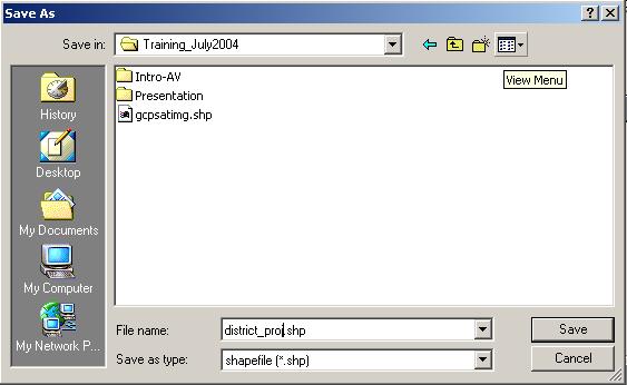
11 Browse directory where you want to save your file (d:\training\district_prj.shp)


12 Click Save Then Next ArcView Projection Utility Summary Page will appear Finish

13 Add theme (district_proj.shp)
14
15 Geometric Correction Raster to Vector conversion
16 Assume you have Satellite image as a base and you need to create data from scanned map, now you have to set geocorrection for your scanned map in order to work with other data layers. Extension: Image to Map World File Creator uses to register the coordinate system with Ground Control Point I. Scanned Map Image to be rectified II. Landsat Image Based Map III. IV. GCP from map to be rectified as gcpmap.txt GCP from Based Map as gcpsatimg.txt FYI: You can also get GCP from GPS Surveying data


17 FYI: Read the coordinate on View Window and save in notepad as txt file The marks will be the same point on both map need to be rectified and based map FYI: Nothing to do with this slide, gcpmap.txt and gcpsatimg.txt are in d:\training_july2004


18 From the File Menu, Extension Click Image to Map World File Creator

 Select File Type")

19 Make Project Window Active Select Table Icon Click Add Button to Add gcpsatimg.txt (based map) Select File Type from List Files of Type as Text Go to Directory that you stored file Click gcpsatimg.txt)


20 Make Project Window Active Select New View Go to View Menu, Click Add Event Theme


21 Select Table as gcpsatimg.txt X field: X_tic Y field: Y_tic Point correspond to X, Y Coordinate will appear in View


22 Go to Theme Menu, Click Convert to shapefile Save as gcpsatimg.shp Click OK Close all Note: Check Point with Coordinate System on the View whether it is correct


23 Open New Project Go to File, Extension check Image to Map World File Creator TIFF Click


24 Dialog will appear, Select the map that you want to change the coordinate (river.tif) Image to be Rectified Select Point shapefile (gcpsatimg.shp) Registration Map

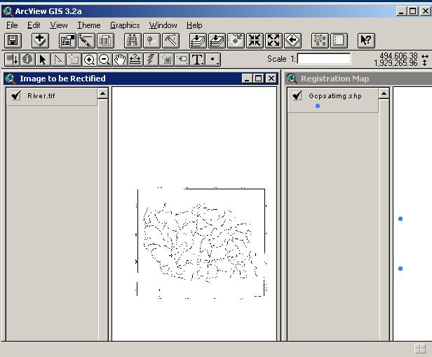
25 Save as xyz.dbf Click OK


26 From Image to be Rectified View, Click to pick Ground Control Point Go to First Point and click at the point From Dialog, Click Yes Red Spot will appear

27 Go to Registration View, Click to pick Ground Control Point Go to First Point and click at the point From Dialog, Click Yes Red Spot will appear


28 finish 6 points on both Views Then Minimize views and Open Ground Control Points table


29 Ground Control Points table appear, Click to calculate RMS value Total RMS value will appear, Click Ok You can also edit the point to less the error


30 IF you satisfy the error, Click to write the file to disk Dialog appear, Click Yes Specify File name river.tfw Click OK


31 The Dialog appear, confirmed --- Click OK Your tif file will be ready to open as the coordinate system that you specified Open New View Add theme Select Data Source type Image Data Source Select river.tif FYI: Accuracy depends on RMS error you accepted at the beginning
32 Projected Image

33 This process we will use the projected scanned image from previous steps as input file to be covert to vector file. -Open new view, Add image river.tiff -Check box in Spatial Analysist At Extensions in File menu


34 -Activate River.tiff, select Covert to Grid in Theme menu -Save new grid file name river-g at your working directory -Click OK -Open attribute table of river-g and click Select at 0 value


35 -Select Convert to Shapefile In Theme menu -Define a new shape file s name In the working directory -Add the new theme and display
Objectives Learn how to work with projections in GMS, and how to combine data from different coordinate systems into the same GMS project.
 v. 10.2 GMS 10.2 Tutorial Working with map projections in GMS Objectives Learn how to work with projections in GMS, and how to combine data from different coordinate systems into the same GMS project.
GIS OPERATION MANUAL
 GIS OPERATION MANUAL 1. Computer System Description Hardware Make Compaq Presario 5004 CPU AMD Athlon 1.1 Ghz Main Memory 640MB CD-ROM 52 X CD-RW 8 X HD 57GB Monitor 19 inch Video Adapter 16 Mb Nvidia
Objectives Learn how to work with projections in SMS, and how to combine data from different coordinate systems into the same SMS project.
 v. 12.2 SMS 12.2 Tutorial Working with map projections in SMS Objectives Learn how to work with projections in SMS, and how to combine data from different coordinate systems into the same SMS project.
Objectives Learn how to work with projections in SMS, and how to combine data from different coordinate systems into the same SMS project.
 v. 12.3 SMS 12.3 Tutorial Working with map projections in SMS Objectives Learn how to work with projections in SMS, and how to combine data from different coordinate systems into the same SMS project.
Objectives Learn how to work with projections in GMS, and how to combine data from different coordinate systems into the same GMS project.
 v. 10.4 GMS 10.4 Tutorial Working with map projections in GMS Objectives Learn how to work with projections in GMS, and how to combine data from different coordinate systems into the same GMS project.
CHAPTER 2 GEOREFERENCING AND SHAPEFILE CREATION
 CHAPTER 2 GEOREFERENCING AND SHAPEFILE CREATION Georeferencing is the process of assigning real-world coordinates to each pixel of the raster. These coordinates are obtained by doing field surveys - collecting
Using All Topo Maps to Bring in a Background Quad Map in Pathfinder Office or ArcView
 Using All Topo Maps to Bring in a Background Quad Map in Pathfinder Office or ArcView Pathfinder Office, ArcView, and ArcExplorer can all display background image files, such as Digital Raster Graphics
Geometric Correction of Imagery
 Geometric Correction of Imagery Geometric Correction of Imagery Present by: Dr.Weerakaset Suanpaga D.Eng(RS&GIS) The intent is to compensate for the distortions introduced by a variety of factors, so that
INTRODUCTION TO GIS WORKSHOP EXERCISE
 111 Mulford Hall, College of Natural Resources, UC Berkeley (510) 643-4539 INTRODUCTION TO GIS WORKSHOP EXERCISE This exercise is a survey of some GIS and spatial analysis tools for ecological and natural
Exercise #5b - Geometric Correction of Image Data
 Exercise #5b - Geometric Correction of Image Data 5.6 Geocoding or Registration of geometrically uncorrected image data 5.7 Resampling 5.8 The Ukrainian coordinate system 5.9 Selecting Ground Control Points
Quick Start Guide for Using TDS NOMAD GPS Equipment (For Team Leaders) Initial Unit Check
 Initial Unit Check") Quick Start Guide for Using TDS NOMAD GPS Equipment (For Team Leaders) Initial Unit Check For each GPS unit, ensure you have: TDS NOMAD GPS Unit Garmin backpack receiver (antenna) Portable battery pack
Quick Start Guide for Using TDS NOMAD GPS Equipment (For Team Leaders) Initial Unit Check For each GPS unit, ensure you have: TDS NOMAD GPS Unit Garmin backpack receiver (antenna) Portable battery pack
Geometric Rectification of Remote Sensing Images
 Geometric Rectification of Remote Sensing Images Airborne TerrestriaL Applications Sensor (ATLAS) Nine flight paths were recorded over the city of Providence. 1 True color ATLAS image (bands 4, 2, 1 in
Georeferencing Topo Sheets and Scanned Maps
 Georeferencing Topo Sheets and Scanned Maps QGIS Tutorials and Tips Author Ujaval Gandhi http://www.spatialthoughts.com This work is licensed under a Creative Commons Attribution 4.0 International License.
ANNEX V RASTER TO VECTOR CONVERSION MANUAL
 ANNEX V RASTER TO VECTOR CONVERSION MANUAL Table of Contents 1. Introduction...1 2. Software used...1 3. Methodology Flow chart...1 4. Scanning hard copy map...1 5. Working with Photo-editor environment
Main concepts of ILWIS 3.0
 CHAPTER 2 Main concepts of ILWIS 3.0 In chapter one, Introduction to ILWIS, you started with ILWIS, and learned the basics of the user interface. This chapter presents some key concepts of ILWIS. In section
Quick Start Guide for Using TDS NOMAD GPS Equipment (For Team Leaders) Initial Unit Check
 Initial Unit Check") Quick Start Guide for Using TDS NOMAD GPS Equipment (For Team Leaders) Initial Unit Check For each GPS unit, ensure you have: TDS NOMAD GPS Unit Garmin backpack receiver (antenna) Portable battery pack
Quick Start Guide for Using TDS NOMAD GPS Equipment (For Team Leaders) Initial Unit Check For each GPS unit, ensure you have: TDS NOMAD GPS Unit Garmin backpack receiver (antenna) Portable battery pack
Technical Specifications
 1 Contents INTRODUCTION...3 ABOUT THIS LAB...3 IMPORTANCE OF THIS MODULE...3 EXPORTING AND IMPORTING DATA...4 VIEWING PROJECTION INFORMATION...5...6 Assigning Projection...6 Reprojecting Data...7 CLIPPING/SUBSETTING...7
Spatial Calculation of Locus Allele Frequencies Using ArcView 3.2
 Spatial Calculation of Locus Allele Frequencies Using ArcView 3.2 This instruction set applies to calculating allele frequency from point data of DNA analysis results within ArcView 3.2. To calculate the
Raster Images Processing
 Software PHOTOMOD Module PHOTOMOD VectOr Raster Images Processing Racurs, Moscow, 2009 PHOTOMOD CONTENTS 1. Raster processing in PHOTOMOD VectOr...3 1.1. Raster map...3 1.2. Raster data conversion...4
v SMS Tutorials Working with Rasters Prerequisites Requirements Time Objectives
 v. 12.2 SMS 12.2 Tutorial Objectives Learn how to import a Raster, view elevations at individual points, change display options for multiple views of the data, show the 2D profile plots, and interpolate
Table. Gis Unit TropMed Mahidol U. 1
 Table Gis Unit TropMed Mahidol U. 1 Create Table by using Tables Icon 2 1 Tables in ArcView 1: Start Program ArcView blank project Select item Tables and Select New button Gis Unit TropMed Mahidol U. 2
User manual. TopoL Mobile 3.0. TopoL Software, s.r.o.
 User manual TopoL Mobile 3.0 TopoL Software, s.r.o. 2005-2012 TopoL Software, s.r.o. All rights reserved. TopoL is registered trade mark of TopoL Software, s.r.o. Obsah Content BASICS... 5 INSTALLATION...
TANGIS GIS INTERFACE AND METADATABASE FOR LAKE TANGANYIKA EFFECTS OF POLLUTION ON BIODIVERSITY PROJECT (LTBP)
") TANGIS GIS INTERFACE AND METADATABASE FOR LAKE TANGANYIKA EFFECTS OF POLLUTION ON BIODIVERSITY PROJECT (LTBP) TANGIS USER MANUAL p.1 CONTENTS INTRODUCTION 4 Purpose 4 ArcView 4 PART ONE TANGIS 6 Requirements
TANGIS GIS INTERFACE AND METADATABASE FOR LAKE TANGANYIKA EFFECTS OF POLLUTION ON BIODIVERSITY PROJECT (LTBP) TANGIS USER MANUAL p.1 CONTENTS INTRODUCTION 4 Purpose 4 ArcView 4 PART ONE TANGIS 6 Requirements
All data is in Universal Transverse Mercator (UTM) Zone 6 projection, and WGS 84 datum.
 Zone 6 projection, and WGS 84 datum.") 111 Mulford Hall, College of Natural Resources, UC Berkeley (510) 643-4539 EXPLORING MOOREA DATA WITH QUANTUM GIS In this exercise, you will be using an open-source FREE GIS software, called Quantum GIS,
111 Mulford Hall, College of Natural Resources, UC Berkeley (510) 643-4539 EXPLORING MOOREA DATA WITH QUANTUM GIS In this exercise, you will be using an open-source FREE GIS software, called Quantum GIS,
GRASS GIS - Introduction
 GRASS GIS - Introduction What is a GIS A system for managing geographic data. Information about the shapes of objects. Information about attributes of those objects. Spatial variation of measurements across
Files Used in this Tutorial
 RPC Orthorectification Tutorial In this tutorial, you will use ground control points (GCPs), an orthorectified reference image, and a digital elevation model (DEM) to orthorectify an OrbView-3 scene that
Exercise 1-1: Using GPS track data to create a field boundary
 Exercise 1-1: Using GPS track data to create a field boundary Learning objectives: Add QGIS plugins Create a point vector file from a text file Convert GPS tracking points to a field boundary Data folder:
+ Make it from the satellite images in sale, (Easier & Faster, but not always available) (It does cost much. An astronomical number!
 (It does cost much. An astronomical number!") BaseMap: + Look for it among the existent digital maps, (Easiest & Fastest because no processing required) (Therefore, the most desirable, but not always available) (It can cost much) + Make it from the
BaseMap: + Look for it among the existent digital maps, (Easiest & Fastest because no processing required) (Therefore, the most desirable, but not always available) (It can cost much) + Make it from the
Terrain Modeling with ArcView GIS from ArcUser magazine
 Lesson 5: Label Features Using GNIS Data Lesson Goal: Use GNIS label data to enhance the Bright Angel model created used in Lessons 3 and 4. GNIS data will be reprojected so that it will align properly
Geoapplications development Control work 1 (2017, Fall)
") Page 1 Geoapplications development Control work 1 (2017, Fall) Author: Antonio Rodriges, Oct. 2017 http://rgeo.wikience.org/ Surname, name, patronymic: Group: Date: Signature: Select all correct statements.
Page 1 Geoapplications development Control work 1 (2017, Fall) Author: Antonio Rodriges, Oct. 2017 http://rgeo.wikience.org/ Surname, name, patronymic: Group: Date: Signature: Select all correct statements.
WILD 2400 ASSIGNMENT #1: GPS TUTORIAL*
 WILD 2400 ASSIGNMENT #1: GPS TUTORIAL* Overview: In this tutorial you will learn how to collect, download, and display data using a Garmin GPSMAP 64 unit, the DNRGPS Application, and Google Earth. For
GIS in agriculture scale farm level - used in agricultural applications - managing crop yields, monitoring crop rotation techniques, and estimate
 Types of Input GIS in agriculture scale farm level - used in agricultural applications - managing crop yields, monitoring crop rotation techniques, and estimate soil loss from individual farms or agricultural
A Practical Guide to Using QGIS
 A Practical Guide to Using QGIS 1.1 INTRODUCTION Quantum GIS (QGIS) is a useful mapping software that enables the compilation and displaying of spatial data in the form of a map. Gaining experience in
v Working with Rasters SMS 12.1 Tutorial Requirements Raster Module Map Module Mesh Module Time minutes Prerequisites Overview Tutorial
 v. 12.1 SMS 12.1 Tutorial Objectives This tutorial teaches how to import a Raster, view elevations at individual points, change display options for multiple views of the data, show the 2D profile plots,
Download elevation model page 2 Re-Project DEM coordinates page 5 Cut region of interest page 10
 1 Download elevation model page 2 Re-Project DEM coordinates page 5 Cut region of interest page 10 Version June 2017, Dr. Jonas von Rütte, Dr. Peter Lehmann 2 Download elevation model for region of interest:
Exercise One: Creating A Map Of Species Distribution For A Publication
 --- Chapter three --- Exercise One: Creating A Map Of Species Distribution For A Publication One of the first, and most common, tasks you will want to do in using GIS is to produce maps for use in presentations,
General Digital Image Utilities in ERDAS
 General Digital Image Utilities in ERDAS These instructions show you how to use the basic utilities of stacking layers, converting vectors, and sub-setting or masking data for use in ERDAS Imagine 9.x
Lab 1: Exploring data format
 Geog 458: Map Sources and Errors January 13, 2006 Lab 1: Exploring data format Data format supported by ArcGIS There are many file types supported by ArcGIS, in addition to specific cartographic objects.
Finding and Using Spatial Data
 Finding and Using Spatial Data Introduction In this lab, you will download two different versions of the National Wetlands Inventory (NWI) dataset for a region of Massachusetts, from a source on the internet.
Exercise One: Estimating The Home Range Of An Individual Animal Using A Minimum Convex Polygon (MCP)
") --- Chapter Three --- Exercise One: Estimating The Home Range Of An Individual Animal Using A Minimum Convex Polygon (MCP) In many populations, different individuals will use different parts of its range.
--- Chapter Three --- Exercise One: Estimating The Home Range Of An Individual Animal Using A Minimum Convex Polygon (MCP) In many populations, different individuals will use different parts of its range.
3. Map Overlay and Digitizing
 3. Map Overlay and Digitizing 3.1 Opening Map Files NavviewW/SprayView supports digital map files in ShapeFile format from ArcView, DXF format from AutoCAD, MRK format from AG-NAV, Bitmap and JPEG formats
MLEP Intermediate GPS Workshop Exercise Two Using Maps
 During this exercise, you will scale coordinates from a map and enter them into the GPS receiver. This requires a ruler (provided) and all calculations require a paper and pencil. During this exercise,
Objectives Learn how to work with projections in WMS, and how to combine data from different coordinate systems into the same WMS project.
 s v. 11.0 Projections / Coordinate Systems WMS 11.0 Tutorial Projections / Coordinate Systems Working with map projections in WMS Objectives Learn how to work with projections in WMS, and how to combine
SPECIFICATIONS FOR G.I.S. DATA/INFORMATION PROVIDED TO ONE-CALL
 SPECIFICATIONS FOR G.I.S. DATA/INFORMATION PROVIDED TO ONE-CALL Digital Mapping Files that we can accept: 1. G.I.S. dataset formats that we can accept: AutoCad File Latest Releases (*.DWG, *.DXF) ESRI
v SMS 13.0 Tutorial GIS P Prerequisites Time Requirements Objectives
 v. 13.0 SMS 13.0 Tutorial Objectives This tutorial demonstrates how to import data, visualize it, and convert it into SMS coverage data that could be used to build a numeric model. This tutorial will instruct
Files Used in this Tutorial
 RPC Orthorectification Tutorial In this tutorial, you will use ground control points (GCPs), an orthorectified reference image, and a digital elevation model (DEM) to orthorectify an OrbView-3 scene that
Combine Yield Data From Combine to Contour Map Ag Leader
 Combine Yield Data From Combine to Contour Map Ag Leader Exporting the Yield Data Using SMS Program 1. Data format On Hard Drive. 2. Start program SMS Basic. a. In the File menu choose Open. b. Click on
Image georeferencing is the process of developing a model to transform from pixel coordinates into GIS coordinates such as meters on the ground.
 Image georeferencing is the process of developing a model to transform from pixel coordinates into GIS coordinates such as meters on the ground. Image rectification is the process of using your georeferencing
Feature Extraction. Contents. 1. Installing Feature Extraction. 2. Using Feature Extraction
 1 Feature Extraction Contents 1. Installing Feature Extraction 2. Using Feature Extraction Adding an image to a view Converting image to grid Resample a grid Connecting to Arc/Info Server Calculating the
Geometric Correction
 CEE 6150: Digital Image Processing Geometric Correction 1 Sources of Distortion Sensor Characteristics optical distortion aspect ratio non-linear mirror velocity detector geometry & scanning sequence Viewing
10.1 Conversions. Grid to Geodetic
 10.1 Conversions Geodetic conversions work with the current geodetic settings. Convert grid coordinates to geodetic (Latitude/Longitude) or vice versa with any of the available projections. All results
Smart GIS Course. Developed By. Mohamed Elsayed Elshayal. Elshayal Smart GIS Map Editor and Surface Analysis. First Arabian GIS Software
 Smart GIS Course Developed By Mohamed Elsayed Elshayal Elshayal Smart GIS Map Editor and Surface Analysis First Arabian GIS Software http://www.freesmartgis.blogspot.com/ http://tech.groups.yahoo.com/group/elshayalsmartgis/
Creating an Event Theme from X, Y Data
 Creating an Event Theme from X, Y Data In Universal Transverse Mercator (UTM) Coordinates Eastings (measured in meters) typically have 6 digits left of the decimal. Northings (also in meters) typically
ANGLES 4/18/2017. Surveying Knowledge FE REVIEW COURSE SPRING /19/2017
 FE REVIEW COURSE SPRING 2017 Surveying 4/19/2017 Surveying Knowledge 4 6 problems Angles, distances, & trigonometry Area computations Earthwork & volume computations Closure Coordinate systems State plane,
Heads-up Digitizing from Scanned Hard-Copy Maps Part I Georeferencing Scanned Images 1
 Data conversion/entry (GIS, databases) November 21-25, 2006 Freetown, Sierra Leone Heads-up Digitizing from Scanned Hard-Copy Maps Part I Georeferencing Scanned Images 1 Objectives: Explore digital archives
2) Make sure that the georeferencing extension is on by right-clicking in the task bar area and selecting Georeferencing
 Make sure that the georeferencing extension is on by right-clicking in the task bar area and selecting Georeferencing") HGIS Workshop Module 1 Georeferencing Large Scale Scanned Historical Maps Objective: Learn the Principles of Georeferencing 1) In ArcMap, open the project 01 data\arcdata_10_1\arcdata\toronto\georeference.mxd
HGIS Workshop Module 1 Georeferencing Large Scale Scanned Historical Maps Objective: Learn the Principles of Georeferencing 1) In ArcMap, open the project 01 data\arcdata_10_1\arcdata\toronto\georeference.mxd
Trimble Access: OSTN15 Transformation Update Procedure (Ireland)
") Trimble Access: OSTN15 Transformation Update Procedure (Ireland) This guide is for use with Trimble Access version 2016.03 & previous versions Prerequisites: Access Controller (Nb. TSC3 used in this guide)
Trimble Access: OSTN15 Transformation Update Procedure (Ireland) This guide is for use with Trimble Access version 2016.03 & previous versions Prerequisites: Access Controller (Nb. TSC3 used in this guide)
Measuring the Lengths of Receiving Polygon Edges
 Measuring the Lengths of Receiving Polygon Edges These instructions enable you to create shapefiles that represent the edge along a receiving polygon that may then be used in the analysis of potential
New Shapes from Input Table: You can also create a new shapefile using data from an input table. You have three options in this case:
 NAME: Distance/Azimuth Tools v. 1.6 Last modified: February 21, 2005 TOPICS: ArcView 3.x, Distance, Bearing, Azimuth, Angle, Point, Line, Polyline, Polygon, Shape, View, Analysis, Tools, Vertices, Shift
APPENDIX 13 TERRAIN NAVIGATOR PRO BASICS. Prepared by the Mapping and Marking Committee. Fifth Edition (Revised and Expanded) June 2014
 June 2014") APPENDIX 13 TERRAIN NAVIGATOR PRO BASICS Prepared by the Mapping and Marking Committee Fifth Edition (Revised and Expanded) June 2014 Published by the Oregon-California Trails Association P.O. Box 1019
APPENDIX 13 TERRAIN NAVIGATOR PRO BASICS Prepared by the Mapping and Marking Committee Fifth Edition (Revised and Expanded) June 2014 Published by the Oregon-California Trails Association P.O. Box 1019
Exercise 03 Creating and Editing Shapefiles Assigned Feb. 2, 2018 Due Feb. 9, 2018
 Exercise 03 Creating and Editing Shapefiles Assigned Feb. 2, 2018 Due Feb. 9, 2018 On the class website I've posted an exercise_03_data.zip file which contains a USGS 7.5' quad map of Laramie (as laramie_quad_usgs_1963.tiff)
CORRECTING RS SYSTEM DETECTOR ERROR GEOMETRIC CORRECTION
 1 CORRECTING RS SYSTEM DETECTOR ERROR GEOMETRIC CORRECTION Lecture 1 Correcting Remote Sensing 2 System Detector Error Ideally, the radiance recorded by a remote sensing system in various bands is an accurate
Making Yield Contour Maps Using John Deere Data
 Making Yield Contour Maps Using John Deere Data Exporting the Yield Data Using JDOffice 1. Data Format On Hard Drive 2. Start program JD Office. a. From the PC Card menu on the left of the screen choose
GIS DataPRO TM. Getting Started with the GIS DataPRO Software. Version 3.0 English
 GIS DataPRO TM Getting Started with the GIS DataPRO Software Version 3.0 English Symbols Used in this Manual Symbols used in this manual have the following meanings: Important paragraphs which must be
Coordinate Transformation for Macau Data Using ArcGIS for Desktop
 Coordinate Transformation for Macau Data Using ArcGIS for Desktop Article ID : TT100062 Software : ArcGIS 10.2 for Desktop Platform : Windows 7, Windows 8, Windows Server 2003, Windows Server 2008/R2 Date
CompassAA v3.50 Quick Start Guide AA Single Image Data Demo
 CompassAA CompassTA www.compassdatainc.com CompassAA v3.50 Quick Start Guide AA Single Image Data Demo Purpose of this Document This document is meant to introduce the new or beginning user to CompassAA
v Water Distribution System Modeling Working with WMS Tutorials Building a Hydraulic Model Using Shapefiles Prerequisite Tutorials None
 v. 10.1 WMS 10.1 Tutorial Water Distribution System Modeling Working with EPANET Building a Hydraulic Model Using Shapefiles Objectives Open shapefiles containing the geometry and attributes of EPANET
Mapping Point Locations along Drill Pad Surveys
 Mapping Point Locations along Drill Pad Surveys These instructions enable you to create point shapefiles of sampling locations along a drill pad. You need to install the extension Distance and Azimuth
ArcGIS Extension User's Guide
 ArcGIS Extension 2010 - User's Guide Table of Contents OpenSpirit ArcGIS Extension 2010... 1 Installation ( ArcGIS 9.3 or 9.3.1)... 3 Prerequisites... 3 Installation Steps... 3 Installation ( ArcGIS 10)...
Measuring Area/Length of Organisms with GIS
 Measuring Area/Length of Organisms with GIS These instructions enable you to measure the length and area of microscopic organisms in ArcGIS from digital photographs. The four-step process involves: georeferencing
Highways by Exor MapCapture Configuration Guide v4.5
 Highways by Exor MapCapture Configuration Guide v4.5 The world s leading highways asset management system This page is intentionally blank Quality Assurance Statement Quality Assurance Statement File:
Exploring GIS Data. I) GIS Data Models-Definitions II) Database Management System III) Data Source & Collection IV) Data Quality
 GIS Data Models-Definitions II) Database Management System III) Data Source & Collection IV) Data Quality") Exploring GIS Data I) GIS Data Models-Definitions II) Database Management System III) Data Source & Collection IV) Data Quality 1 Geographic data Model Definitions: Data : A collection of related facts
Exploring GIS Data I) GIS Data Models-Definitions II) Database Management System III) Data Source & Collection IV) Data Quality 1 Geographic data Model Definitions: Data : A collection of related facts
Pond Distance and Habitat for use in Wildlife Modeling
 Pond Distance and Habitat for use in Wildlife Modeling These instructions enable you to aggregate layers within a study area, calculate new fields, and create new data out of existing data, for use in
Legacy 6000 MID-TECH ESC. RMS-Office User Guide. Roadway Management S Y S T E M
 Legacy 6000 MID-TECH ESC RMS-Office User Guide Roadway Management S Y S T E M TM 98-05065 Roadway Management S Y S T E M TM RMS-Office USER GUIDE PN - 98-05065 RO Chapter 1 - RMS Office Introduction...
v GMS 10.0 Tutorial MODFLOW Transient Calibration Calibrating transient MODFLOW models
 v. 10.0 GMS 10.0 Tutorial MODFLOW Transient Calibration Calibrating transient MODFLOW models Objectives GMS provides a powerful suite of tools for inputting and managing transient data. These tools allow
New Media in Landscape Architecture: Advanced GIS
 New Media in Landscape Architecture: Advanced GIS - Projections and Transformations - Version 10.2, English ANHALT UNIVERSITY OF APPLIED SCIENCES Hochschule Anhalt Author: Dr. Matthias Pietsch Tutorial-Version:
Mapping 2001 Census Data Using ArcView 3.3
 Mapping 2001 Census Data Using ArcView 3.3 These procedures outline: 1. Mapping a theme (making a map) 2. Preparing the layout for printing and exporting the map into various file formats. In order to
Using ArcGIS 10.x Introductory Guide University of Toronto Mississauga Library Hazel McCallion Academic Learning Centre
 Using ArcGIS 10.x Introductory Guide University of Toronto Mississauga Library Hazel McCallion Academic Learning Centre FURTHER ASSISTANCE If you have questions or need assistance, please contact: Andrew
How to Relay Information About Where You Are
 How to Relay Information About Where You Are 2017 12 18 Gary Ataman Five Winds Backcountry Ski Club President Where Are You? When you are in the backcountry keep track of where you are. When incidents
Introduction to Solo Forest
 Introduction to Solo Forest Project Settings Collecting Data Office Procedures - Exporting Shapefiles - Syncing with the PC - Transferring files Opening Solo Forest To open Solo Forest, select Start >
ArcView QuickStart Guide. Contents. The ArcView Screen. Elements of an ArcView Project. Creating an ArcView Project. Adding Themes to Views
 ArcView QuickStart Guide Page 1 ArcView QuickStart Guide Contents The ArcView Screen Elements of an ArcView Project Creating an ArcView Project Adding Themes to Views Zoom and Pan Tools Querying Themes
Convert AutoCAD files to ESRI ShapeFiles, to be used in Leica icon telematics
 Convert AutoCAD files to ESRI ShapeFiles, to be used in 1 1 Convert AutoCAD files to ESRI ShapeFiles, to be used in Background When you use it is possible to log the machine's position and visualize this
Contents of Lecture. Surface (Terrain) Data Models. Terrain Surface Representation. Sampling in Surface Model DEM
 Data Models. Terrain Surface Representation. Sampling in Surface Model DEM") Lecture 13: Advanced Data Models: Terrain mapping and Analysis Contents of Lecture Surface Data Models DEM GRID Model TIN Model Visibility Analysis Geography 373 Spring, 2006 Changjoo Kim 11/29/2006 1
Lecture 13: Advanced Data Models: Terrain mapping and Analysis Contents of Lecture Surface Data Models DEM GRID Model TIN Model Visibility Analysis Geography 373 Spring, 2006 Changjoo Kim 11/29/2006 1
3.1 Units. Angle Unit. Direction Reference
 Various settings allow the user to configure the software to function to his/her preference. It is important to review all the settings prior to using the software to ensure they are set to produce the
CONTENTS 1 INTRODUCTION 3 ARCGIS 5 START ARCMAP 11 IMPORT 1: MAP DATA 12 ADD WIND FARM DATA 21 CREATE A MAP TO INSERT IN A REPORT 32
 CONTENTS CONTENTS 1 INTRODUCTION 3 SCENARIO 3 WHAT WILL I LEARN? 3 WHAT DATA DO I HAVE? 4 ARCGIS 5 ARCMAP 6 ARCCATALOG 8 ARCTOOLBOX 9 START ARCMAP 11 IMPORT 1:250000 MAP DATA 12 CREATE A GROUP LAYER 16
Aerial Photo Rectification
 Aerial Photo Rectification ERDAS Imagine 2016 Description: We will be using ERDAS Imagine to georeference aerial photos to a DOQ image. We will try to achieve this with a total RMS (root mean square) error
A Second Look at DEM s
 A Second Look at DEM s Overview Detailed topographic data is available for the U.S. from several sources and in several formats. Perhaps the most readily available and easy to use is the National Elevation
Data Import and Quality Control in Geochemistry for ArcGIS
 Data Import and Quality Control in Geochemistry for ArcGIS This Data Import and Quality Control in Geochemistry for ArcGIS How-To Guide will demonstrate how to create a new geochemistry project, import
Photo2GPS Instructions:
 Photo2GPS Instructions: Photo2GPS is a program designed to read a text file of track points and the contents of a folder containing your digital photographs then create coordinates with links to the associated
COORDINATE TRANSFORMATION. Lecture 6
 COORDINATE TRANSFORMATION Lecture 6 SGU 1053 SURVEY COMPUTATION 1 Introduction Geomatic professional are mostly confronted in their work with transformations from one two/three-dimensional coordinate system
Vector-Based GIS Data Processing. Chapter 6
 Vector-Based GIS Data Processing Chapter 6 Vector Data Model Feature Classes points lines polygons Layers limited to one class of data Figure p. 186 Vector Data Model Shapefiles ArcView non-topological
How do I apply the patch files?
 How do I apply the patch files? 1. Once the patch file has been saved to your hard disk, use Windows Explorer (Start > Programs > [Accessories > ] Windows Explorer) to browse to the directory where the
Lesson 2 Installing and Using Quantum GIS (QGIS)
") Lesson 2 Installing and Using Quantum GIS (QGIS) Use file Explorer to open County QGIS portable hard drive provided. The program execute (.exe) will be at the bottom of the list. Double click on the file.
Lesson 2 Installing and Using Quantum GIS (QGIS) Use file Explorer to open County QGIS portable hard drive provided. The program execute (.exe) will be at the bottom of the list. Double click on the file.
In order to follow this set of directions you will need the following
 How to Create Maps & Figures in ArcView 9x In order to follow this set of directions you will need the following 1) the Jenny s Louisiana GIS Instructional CD 2) a computer with ArcGIS on it (version 9.0
GIS data input. In the early days of GIS 1980s and early 1990s. We used canned datasets for teaching (from USA)
") GIS data input GIS is the automated : acquisition - input management analysis display of spatial data In the early days of GIS 1980s and early 1990s There were no or little GIS data We used canned datasets
GIS data input GIS is the automated : acquisition - input management analysis display of spatial data In the early days of GIS 1980s and early 1990s There were no or little GIS data We used canned datasets
K-Console: Postprocessing
 K-Console: Postprocessing K-MATIC 10/19/2015 tel tel UK: UK: 0845 0845 603 603 1214 1214 IRE: IRE: 01 01 456 456 4702 4702 email: email: support@korecgroup.com Page 1 How To PostProcess This How To guide
Downloading and Repairing Data
 Overview In this exercise you will find and download spatial data for the town of Lowville in Lewis County, New York. The general idea of the exercise has changed from one of simply downloading data and
Lab 2. Vector and raster data.
 Lab 2. Vector and raster data. The goal: To learn about the structure of the vector and raster data types. Objective: Create vector and raster datasets and visualize them. Software for the lab: ARCINFO,
v SMS 12.3 Tutorial GIS P Prerequisites Time Requirements Objectives
 v. 12.3 SMS 12.3 Tutorial Objectives This tutorial demonstrates how to import data, visualize it, and convert it into SMS coverage data that could be used to build a numeric model. This tutorial will instruct
METRIC AND QUALITATIVE EVALUATION OF QUICKBIRD ORTHOIMAGES FOR A LARGE SCALE GEODATABASE CREATION
 METRIC AND QUALITATIVE EVALUATION OF QUICKBIRD ORTHOIMAGES FOR A LARGE SCALE GEODATABASE CREATION Maurizio Barbarella, Michela Zanni DISTART Università di Bologna maurizio.barbarella@mail.ing.unibo.it,