For construction levelling. Jogger 20: #LG762263, Jogger 24: #LG762264, Jogger 28: #LG783739, Jogger 32: #LG783740
|
|
|
- Piers Johns
- 5 years ago
- Views:
Transcription


1 CATALOGUE


 1km d run, 1mm (with standard) - DNA10 accuracy: 1km d run, 0.9mm (with Invar) 1km d run, 1.")
2 Automatic Levels Pentax AP-200 Rugged and dependable, ideal for engineering and construction use. AP224: #TBA, AP228: #TBA AP230: #TBA, AP241: #TBA - 20, 24 or 28x magnification - Short focusing of 0.4m - IP54 weather proof Jogger 20/24 For construction levelling. Jogger 20: #LG762263, Jogger 24: #LG762264, Jogger 28: #LG783739, Jogger 32: #LG Jogger 20: 1km d run, 2.5mm - Jogger 24: 1km d run, 2.0mm - Jogger 28: 1km d run, 2.0mm - Jogger 32: 1km d run, 2.0mm - 20, 24, 28 0R 32x magnification - IP54 weather proof - Operating temp -20 C to +40 C - 1m shortest focusing distance - 1 year warranty NA700 series Mid range levelling. NA720 #LG641982, NA724 #LG641983, NA728 #LG641984, NA730 #LG NA720: 1km d run, 2.5mm - NA724: 1km d run, 2.0mm - NA728: 1km d run, 1.5mm - NA730: 1km d run, 1.2mm - Shortest focus range of 0.5m - 3 year warranty - IP57 weather proof - Operating temp -20 C to +50 C 2 Sprinter 50/150M/250M Digital Level Simply aim, focus and press measure. Fast and error free digital levelling Sprinter 50: #LG762628, Sprinter 150: #LG762630, Sprinter 250: #LG Sprinter 50 accuracy: 1km d run, 2mm - Sprinter 150/250 Accuracy: 1km run, 1mm - Measures bar coded staff up to 100m away point memory for M models - 2 year warranty DNA 03/10 Digital Level Up to a 50% time saving over conventional levels. DNA03: #LG723289, DNA10: #LG Alphanumeric keypad - DNA03 accuracy: 1km d run, 0.3mm (with Invar) 1km d run, 1mm (with standard) - DNA10 accuracy: 1km d run, 0.9mm (with Invar) 1km d run, 1.5mm (with standard) - 6,000 measurement internal memory - Rechargeable or Alkaline - Measures bar coded staff up to 110m away - 2 year warranty NAK2 For survey grade levelling. #LG Auto level - Accuracy 1km d run, 0.7mm - 0.3mm accuracy with parallel plate micrometer - 32 x magnification - Operating temp -20 to IP53 weather resistant - 3 year warranty


3 Theodolites Prexiso T.0.2 #LG accuracy - Laser plummet - Dual LCD screens - Audible notice for 90 turns Leica Builder 109 #LG accuracy - Laser plummet - Dual axis compensator - Audible notice for 90 turns Pentax ETH-510 # accuracy - 30x optical magnification - Dual LCD screens - Optical plummet Tamaya TD-4 - Designed for weather balloon tracking - Optional printer for real time print outs - 18x optical magnification - Create graphs showing relationship between altitude, wind speeds, and wind directions 3


4 Total Stations Leica Builder Leica Builder 100 if you need to trust angles and alignments #LG With a laser plummet for simple and fast setup over control line, dual axis compensation for accurate plumbing, endless drives eliminating steps, audible notice for 90 turns, graphical levelling aid for fast and convenient setup and IP55 rating, the Leica Builder 100 is an outstanding theodolite. Leica Builder 200 when tapes are a thing of the past #LG Traditional layouts require many steps and manipulations. The Leica Builder reduces these steps. As such the Leica Builder 200 adds benefit by reducing the number of set-ups and offers laser-aided layouts up to 80m/260ft. Its serial interface allows connection to any 3rd party device/program. 3 languages loadable. Leica Builder 300 when a construction plan goes digital #LG Call up plan data and record points eliminates read and write errors, data exchange via industrial grade USB stick simplifies data handling, a direct DXF download function, tracking mode, setup any-where function, optional volumes calculation and laser distance measurements up to 120m/400ft make the Leica Builder 300 a real workhorse. Leica Builder 400 if performance makes the deal With an extended working range to prisms of up to 500m/1600ft (optional 3500m/2.2mi), a full alpha-numeric keyboard for rapid entry/ recall of point numbers (cell phone style use), short range laser distance measurements with 15m/50ft for quick as-builts of inaccessible points and a huge memory of 50,000 points, Leica Builder 400 is the high performer in its league. Leica Builder 500 when versatility meets efficiency #LG The flagship of the Leica Builder Series equipped with all of the above features plus wireless communication via Bluetooth, full laser distance measurements up to 250m/820ft and up to 1.5mm accuracy at 100m covers the full range of tasks to be performed on any construction site. An -30 C option is available additionally. Builder Specifications Leica Builder 100 Leica Builder 200 Leica Builder 300 Leica Builder 400 Leica Builder 500 Full Power Site Software 3 Wireless Communication 3 Prism Measurement Mode 3 3 Full alphanumeric keyboard 3 3 Volumes Calculation Data Im/Export to USB Stick PC/Handheld Interface Laser Distance Measure Control Line Setup Languages Levelling Aid Dual Axis Compensator Laser Plummet Li-Ion Batteries Internal Memory [points] Angular Accuracy 9, 6 9, 6 9, 6 9, 5 9, 5, 3 Distance without reflector (90% reflective) 80 m 120 m 150 m 250 m Distance to reflective tape (60mm x 60mm) 250 m 250 m 250 m 250 m Distance to glass prism 500 (3500) m 500 (3500) m 4

5 Total Stations Leica FlexLine Plus For basic to advanced users with the need for flexibility and performance. To ensure that you stay one-step-ahead, Leica Geosystems has developed a new generation of Total Stations using the latest technology, the Leica FlexLine. For the first time, hardware and software options can be simply selected so that the FlexLine Total Station exactly meets your requirements. Leica FlexLine TS02plus Best-In-Class Precision The ideal Total Station for standard measurement tasks. Designed especially for mid-to-low accuracy applications. It comes complete with a standard set of application software that guide you through your daily work. Leica FlexLine TS06plus Top Precision meets High Efficiency Ideal for mid to high accuracy applications. The full alpha-numerical keyboard and built-in Bluetooth, USB host and device board offer highest user friendliness. Leica FlexLine TS09plus Full Precision at High Performance The brilliant colour display with touch operation, built-in Bluetooth, USB host and device board offer the highest performance and ease of use. TS02 TS06plus TS09plus 1" angular accuracy 3 Enhanced measurement accuracy to prism Reflectorless measurement range 1.5 mm + 2 ppm 500 m option 1.5 mm + 2 ppm 500 m included / 1000 m option 1.5 mm + 2 ppm 500 m included / 1000 m option Display with graphics and display illumination 3 included 0 Optional Not Available Black & White high resolution Black & White high resolution Q-VGA Colour & Touch Full alpha-numerical keyboard with function keys 3 3 Second Keyboard Keyboard illumination 3 Electronic Guide Light 0 3 USB Type A and mini B 3 3 Bluetooth Wireless 3 3 SD Card Imaging capability Smart Station capability Onboard software (package content) FlexField plus (standard) FlexField plus (advanced) FlexField plus (full) 5


6 MultiStation - Nova MS60 We know that making the right decision is not always easy. Wrong decisions are costly and can have long lasting implications. That is why Leica have invented Leica Nova which merges all they are famous and trusted for. In a single instrument, Leica Nova MultiStation combines digital imagery, total station capabilities and 3D laser scanning. Coupled with the latest Point Cloud Software Technology, Leica Nova gives you access to a new dimension in measuring technology. We cannot decide for you, but Leica Nova can help you to make the right decision when it really matters. Take pride, make the right decision! Every time. Everywhere. Proven technology for unmatched versatility The Leica Nova MS60 provides proven total station functionality with superior sensor integration for highest precision, performance and full automation of measurement procedures. Together with the benefits of GNSS connectivity, the Leica Nova MS60 offers complete versatili ty by delivering reliable results wherever and whenever you need them. Integrated scanning of every detail The Leica Nova MS60 integrates 3D point cloud measurements into a regular survey workflow. This lets you collect and visualise your topographic survey data together with detailed high-precision scans. Save time by checking your data for integrity and relevance and avoid costly reworking or returns to the field. Benefit from better decisions with richer and more detailed data. Image assistance for every situation the Leica Nova MS60 features an overview camera and a telescope camera with 30x magnification and autofocus. State-of-the-art image processing technology delivers live fluid video streaming of highest image quality. The imaging capabilities of the Leica Nova MS60 open up new opportunities of operating the MultiStation in an almost infinite range of applications. Precise long-range scanning 1000 pts/sec up to 300 m Scan range up to 1000 m Millimetre scan precision Fast pinpoint r2000 edm Reflectorless range beyond 2000 m Significantly reduced measurement times Wide angle overview camera Target acquisition with 20 Hz live video stream Simple and comprehensive image-assisted documentation Automatic capture of panoramic images High resolution telescope camera 30x magnification for high resolution images & precision target acquisition Automatic focussing Robust ip65 design Highest protection rating in the industry Withstands MIL standard blowing rain test scan what you need use as total station highest image quality In-field point cloud processing Automatic point cloud registration 3D point cloud viewer On-board surface modelling Ultra-dynamic automation Best-in-class in speed and acceleration Automatically find prisms with PowerSearch Maximised service intervals 6


7 Total Stations Nova TS60 The latest generation of surveying technology concentrates on a central factor: precision. In order to address every challenge and make fast decisions, you need the ultimate in precision and perfection that today s technologies can offer. And that is precisely what you get with the Leica Nova TS60. The Leica Nova TS60 redefines the meaning of precision with its optimum combination of angle and distance measuring. At the same time, it offers extraordinary acceleration and speed for highest efficiency, integrated overview and telescope cameras and the latest intuitive SmartWorx on-board software. True perfection: discover the Leica Nova TS60.. Leica Smartworx The Leica Nova TS60 is equipped with the latest Leica SmartWorx software to provide unparalleled ease-of-use and performance. No matter how complex the application, Leica SmartWorx has functionality to complete every task with ease. With identical operation for TPS and GNSS, changing between Leica TPS and GNSS instruments is smooth and simple. highest image quality Image assistance for every situation The Leica Nova TS60 features an overview camera and a telescope camera with 30x magnification and autofocus. State-of-the-art image processing technology delivers live fluid video streaming of highest image quality. The imaging capabilities of the Leica Nova TS60 open up new possibilities for operating this perfect total station in an almost infinite range of applications. Proven technology for unmatched versatility The Leica Nova TS60 provides proven total station functionality with superior sensor integration for highest precision, performance and full automation of measurement procedures. Together with the benefits of GNSS connectivity, the Leica Nova TS60 offers com plete versatility by delivering reliable results wherever and whenever you need them. functionality for every application Unrivalled angular accuracy 0.5 Angular accuracy 0.5 Automatic Aiming accuracy (ATR) Pinpoint edm-accuracy 0.6 mm + 1 ppm to prisms 2 mm + 2 ppm to any surface Wide angle overview camera Target acquisition with 20 Hz live video stream Simple and comprehensive image-assisted documentation Automatic capture of panoramic images High resolution telescope camera 30x magnification for high resolution images and precision target acquisition Automatic focussing Leica Smartworx software Complete suite of applications Easy-to-use with clearly laid out graphics, logical menu structures and simplified workflows Ultra-dynamic automation Best-in-class in speed and acceleration Automatically find prisms with PowerSearch Maximised service intervals most precise total station 7


8 Total Stations - Leica Nova Software Leica MultiWorx Leica MultiWorx for AutoCAD is for point cloud processing newcomers using Leica Nova MS60 s integrated laser scanning capability. This plug-in for AutoCAD and Civil 3D lets drafters and designers work with rich, 3D point clouds in a familiar CAD environment. It also provides simpler and more powerful tools for navigating point clouds and creating deliverables than native CAD capabilities. Point Cloud Management Simplified opening of point cloud data; 3D limit boxes, slices, interactive visualisation of all size data sets. Rendering Level of Detail (LOD) graphics, «Single pick» point cloud density control Visualisation Intensity mapping, true colour; limit boxes, slices. TruSpace panoramic viewer: Select view point from keyplan; Drive CAD viewpoint from TruSpace; Quick limit box in CAD from single pick; Send point picks from TruSpace to CAD command; Includes background images Drafting Support Automatically orientate UCS to walls and floors; UCS Orientation Support with a few simple picks on the point cloud; High point, low point and ground point SmartPick Snapping; Creation of COGO points on a user specified Points on a Grid; Project linework to Workplanes Leica Infinity TPS, GNSS, images, scans and more: so many different kinds of data come together on a field project no problem at all for Leica Infinity. Numerous data formats can be edited, archived and exported to CAD applications easily, without data loss and without the hassles involved in conversion. This not only for data from different instrument types, but also from multiple sites and survey teams. Leica Infinity differentiates between and transparently processes all data for simplified, automated and logically expanded workflows, and a faster overview of the project as a whole. General Components - Data and Project Management - Data Import - Data Export - 3D viewing - Editing - Reporting Feature Code Processing - Code Manager - Feature Code Processing Data Processing options - TPS data-processing - 3D Network Adjustment - Surfaces - Scanning - Imaging 8


9 Total Stations Leica Viva Total Viva Solution - Leica TPS together with CS controller, GNSS and SmartStation. The Leica Viva TS11 and TS15 are the fastest imaging total stations in the world. Productivity and documentation rises to the next level. Complete every project easier and faster than ever before. Designed to work seamlessly together, Viva controller, Viva GNSS, Viva TPS, and Viva SmartStation offer a comprehensive system. TS11 Manual Total Station The most advanced manual total station Leica Viva TS11, is the most advanced manual total station with the inclusion of advanced imaging functionality and the Leica SmartWorx Viva easy-to-use onboard software. Leica Viva TS11 raises productivity to the next level with imaging and Leica SmartWorx Viva software. The unique capture-sketch-link functionality enables high resolution total station images to be captured, enhanced with sketching and then linked to any point of interest. Costly revisits can be avoided to significantly improve productivity. Every vision on every scale becomes reality with ease. TS15 Robotic total station The fastest imaging total station The Leica Viva TS15 is a state-of-the-art total station that provides advanced imaging functionality combined with dynamic tracking capabilities for one-person surveying. Furthermore, Leica Viva TS15 features the easy-to-use Leica SmartWorx Viva onboard software. The Leica Viva TS15 adds a high-resolution camera to further enhance total station productivity. Traditional robotic operation is significantly improved with imaging features through Image Assisted Surveying and Documentation. Thanks to live streaming of the total station view on the robotic controller, remote points can be easily measured with the tap, turn & measure functionality without returning to the total station. SmartStation & SmartPole Extend the TS15 by integrating full GNSS functionality to further improve productivity. The TS15 can be used as a Leica SmartStation for TPS setup without the need of control points, traverses and resections, or as a Leica SmartPole to save time with setup On-the-fly and measure parallel with TPS and GNSS for double productivity. TS12 - Robotic Total Station Robotic performance on a budget Leica Viva TS12 is packed with features, such as the unique PowerSearch sensor which finds prisms regardless of their location in seconds and the light weight Leica CS10 controller which provides secure wireless connectivity to the total station. Together with the easy-touse Leica SmartWorx Viva software, robotic surveying has never been so easy and productive. 9


10 Leica Monitoring Whether you monitor the movement of a volcanic slope, the structure of a long bridge or track the settlement of a dam; whether you measure, analyse and manage the structures of natural or man-made objects: the monitoring systems by Leica Geosystems provide you with the right solution for every application. Our solutions provide reliable, precise data acquisition, advanced processing, sophisticated analysis and secure data transmission. Using standard interfaces, open architectures and scalable platforms, the solutions are customizable to meet individual requirements for permanent and temporary installations, for single sites and monitoring networks. Leica TM50 Monitoring Software GeoMoS, GeoMoS Web, Spider, GNSS QC SOLUTIONS SENSORS SOFTWARE GNSS, Total Stations, Geotechnical Sensors Leica GeoMoS software provides a highly flexible automatic deformation monitoring system that is able to combine geodetic, geotechnical and meteorological sensors to match the needs of your monitoring project, whether it is large or small, temporary or permanent With the addition of the GeoMoS Web service, visuali sation and analysis of monitoring data can be performed anywhere and anytime using a web browser, mobile phone or tablet. Make important decisions with Leica GeoMoS. GeoMoS Scanning Read between the lines The Leica Nova MS60 with Leica GeoMoS: A break-through in deformation monitoring Contineous operation and reliability The Leica Nova TM50 meets the challenge of 24 hours, 7 days a week monitoring applications. It is designed to withstand the roughest use in the most severe environments. The Leica Nova TM50 will operate throughout a wide temperature range and is protected against wind driven rain, sand and dust. The Leica Nova TM50 is fully operational in bright sunlight and complete darkness. Highest measurement accuracy 0.5 Angular accuracy 0.6 mm + 1 ppm distance accuracy 0.5 Automatic Aiming (ATR) accuracy and 3 km range Robust IP65 design -20 C to +50 C operating temperature IP65 protection against wind, dust & rain Automatic deformation scanning Seamless workflow with brand new n.vec Technology 3D visualisation of deformation clouds High resolution overview and telescope camera Automatic capturing of panoramic images 30x magnification for high resolution images and fine aiming Automatic focus Flexible connectivity Wireless LAN USB port Bluetooth, RS Monitoring Prism GMP104 #LG GMP104 Replica #A1002 Mini Prism with L-bar : Mini monitoring prism mounted in metal holder. Supplied with L-bar for fixed installations. The prism offset is dependant on the mounting position. Max. IR range of 2000m (7000ft). Monitoring Prism GPR112 #LG Omni 1100-C #54106 CST # Large diameter monitoring prism for long range measurements. For installation on M8 or 5/8 threaded bolts. Built-in filter prevents condensation on the reflecting surface. Rain/ snow cover available separately. Max. range with IR of 2500m. Power management External power supply Internal battery charging High dynamic piezo drives Best-in-class speed and acceleration Zero noise pollution Maximum service intervals


. - Fully scalable sensor allows you to buy only what you need today and upgrade with additional functionality as you need it.")
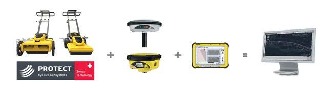
11 Leica Viva GNSS Leica Viva GS16 Leica Viva GS10 Leica Viva GNSS is a complete range of versatile GNSS solutions for you. From completely integrated, to totally modular solutions; Viva GNSS provides a system to master all of your tasks. Leica Viva GS16 Delivering the most accurate positions The Leica Viva GS16 is the most compact and powerful, self-learning GNSS smart antenna. Working with the leading RTK technology, the Viva GS16 meets the highest standards in measurement excellence with RTKplus and SmartLink. The growing number of signals from an ever increasing satellite constellation demands a GNSS receiver to be smarter than ever before. RTKplus intelligently adapts to changing conditions by selecting the optimal signals to deliver the most accurate positions. Leica Viva GS10 / GS15 Work as you want to The Leica GS10 and GS15 are designed to suit any surveying task - Exchangeable communication devices for field base stations and RTK rovers with removable SIM cards (Built-in for GS15). - Fully scalable sensor allows you to buy only what you need today and upgrade with additional functionality as you need it. - Integrated web server to configure the logging of Leica or RINEX raw data and measure with one button press in the field. Leica Viva GS15 Proven GNSS technology Built on years of knowledge and experience, the hallmarks of Leica GNSS reliability and accuracy. - SmartCheck RTK data-processing to guarantee correct results. - SmartTrack advanced four constellation tracking of all GNSS satellites today and tomorrow. - SmartRTK delivers consistent results in all networks. Leica Viva GS08 Plus NetRover Simple Turnon & Measure GNSS solution The Viva NetRover using the new Leica Viva GS08 GNSS receiver has been designed to create an ideal RTK network rover. Consisting of a GS08 GNSS receiver and a CS10 3.5G field controller to create an easy to use all-in-one GNSS Network Solution. The Leica Viva NetRover is optimised for RTK network use. All components work seamlessly together, creating a lightweight and cable-free network rover. The NetRover automatically connects to any reference station network, and with full support of the RTCM 3.1 transformation message, it is no longer necessary to measure control points for the determination of a local transformation, saving time and reducing errors. Leica Viva GS12 SmartPole Complete freedom of choice The Viva GS12 is a lightweight receiver that ergonomically combines GNSS and TPS for a SmartPole setup, an integrated All-onthe Pole system for productive one-person surveying. By combining the GS12 GNSS receiver and a 360º prism, you can use GNSS to orientate your TPS and easily switch between GNSS and TPS to measure any point with total flexibility. With the SmartPole there is no need to first measure orientation points. By starting the survey and conducting setup onthe-fly whilst completing measurements, you save time in survey planning and execution. Viva GS15 GNSS receiver can also be used with Viva SmartPole. Leica Viva Uno Packed with features and designed for use in extreme environments. - IP67, operating temperature -30 to +60 C - SD and CF cards and USB stick support - Camera, WLAN, Bluetooth, colour VGA touch screen - Easy to use, handheld GNSS data collector - 14 channel L1 GPS, GLONASS & SBAS sensor - Post processing accuracy 10mm 2ppm - DGPS accuracy < 0.4m - Wide range of apps for all surveying work Leica Viva Uno CS15 (left) and CS10 (right). 11


12 Leica Viva Field Controller Leica Viva contains a unique portfolio of wirelessly connected field controllers. With a complete range of easy-to-use software your work can start immediately and be finished faster then ever before. Your benefit - Simply select your perfect controller and software for unrivalled efficiency. Leica Viva Controller CS-15 #LG Full 65 key QWERTY keyboard. Leica Viva Controller CS-10 #LG alpha-numeric keys. ACTIVE ASSIST Imagine being in the field and coming across a problem that prevents you from finishing the job. You call your local support engineer, but have trouble explaining your exact problem. By simply pressing a button in Leica SmartWorx Viva, you can activate Leica Active Assist, and your local support engineer can securely access your device and see exactly what you see. By pressing the buttons for you, your support engineer can guide you back to full productivity within minutes. You can continue with confidence to complete the survey, and know if the problem ever arises again, you can solve it yourself after being guided step-by-step through a solution. Simply productive surveying software With clear graphics, non-technological terminology and simplified workflows SmartWorx Viva is incredibly easy to use. - Survey, coding and line work - Advanced coordinate system handling - Wide range of apps for all surveying and staking tasks 3.5G Modem The Viva CS10 3.5G and CS15 3.5G field controllers include a fully integrated highspeed 3.5G modem to connect to RTK reference networks and allow mobile broadband internet connectivity for field-tooffice data transfer. Built for the field Designed for extreme environments, you can always rely on your CS10 & CS15. Comfortable in the hand, and easy-to-use for all tasks. - IP67 and operating temperature -30 to 60 C - Tactile, fully illuminated, rubber keypad (numeric on CS10, alphanumeric QWERTY on CS15) - 2 Megapixel camera (Perfectly placed for taking pictures when in hand or mounted on pole) - Colour, VGA touch screen, illuminated Flexible communication and data handling Stay connected with a wide range of communication and data storage options. Your CS10 & CS15 is ready for all challenges. - Fully integrated wireless Intenna technology (Bluetooth, WLAN, TPS Radio, GSM/UMTS 3.5G) - Choice of 2 connector modules Lemo module: Lemo (USB and serial), USB A host, 7-pin connector, power RS232 module: RS232, USB A host, USB mini AB OTG, 7-pin connector, power - Data storage using SD Card, CF Card, USB memory stick Work how you like Designed as part of the Leica Viva series, but versatile to work with many instrument and software combinations. - Ideal for use with all Leica Viva Series Total Stations and GNSS sensors. - Perfectly designed to be used with SmartWorx Viva surveying software. - Powerful ARM core processor for many software applications. 12


13 Leica Viva GIS Leica Viva Controller Zeno5, Zeno20 & CS20 GNSS Leica Zeno 10, Zeno 15 & CS25 GNSS are designed for high-accuracy mapping in real-time and post-processing. CS20 Zeno20 The most rugged and versatile GNSS/ GIS Handhelds in the market High performance GNSS/GIS handhelds give you all the power you need. The perfect field tools for maintaining your GIS whether you are working for a utility company, local government, federal agency, or for anyone managing or mapping infrastructure or assets. Leica Zeno GIS series delivers the quality and reliability you can trust. - IP67 and -30 to 60 C operation - Combine GIS and Survey equipment High-Performance sub-meter GNSS/GIS Handhelds Delivering consistent sub-meter accuracy both real-time and post-processed. Leica Zeno 10 and Leica Zeno 20 handhelds combine a highperformance sub-meter GNSS sensor with a rugged handheld for anyone who needs accurate and reliable data even in the most demanding environments. - DGPS <0.4 m - SBAS <1.2 m - Post-processed sub-meter decimetre Packed with power for outstanding performance The optional docking station ensures quick, direct and easy access to the data you have measured in the field. Just plug in and field data is downloaded, post-processed and updated in Zeno Office, with just one simple click. Together with full support of all survey equipment, data maintenance has never been so easy. - Convenient wireless or wired data download & upload. Leica Viva GIS Communications The Zeno models are available with 3.5G builtin communication modules (integrated 3.5G modem, WLAN and Bluetooth). The Leica Zeno GPS/GNSS and its integrated compatibility with RTK reference station networks enables GIS users to map features in high-accuracy anywhere and anytime, without requiring an external Bluetooth mobile phone. Leica Zeno Software The Leica Zeno GIS series offers an ideal set of tools for anyone who needs more accurate data in a GIS database. All GNSS post-processing is automated; GIS and GNSS technologies are seamlessly combined in one easy solution. Leica Zeno Office Available as Leica Zeno Office and Leica Zeno Office on ArcGIS an extension to ArcGIS Desktop. Leica Zeno Office is a software package to maintain, manage and post-process GIS, GNSS and surveying data. Zeno Office also provides an easy interface between the field and CAD/GIS applications such as MobileMatriX, AutoCAD, ArcGIS or Microstation. Leica Zeno Field Leica Zeno Field is an OEM version of ArcPad 8 and provides in addition to the well known ArcPad functionality: - GNSS raw data logging, - Easy handling of GNSS configurations (such as DGPS settings), surveying technology made available to the GIS user. - Automated re-dial to real-time source in case connection gets interrupted. - Feature accuracy management EasyIn and EasyOut Leica Zeno GIS introduces the new EasyIn/ EasyOut workflows to simultaneously: - Check-in feature and GNSS raw data - Post-Process and - Update feature vertices Zeno5 GIS controller. 13

14 Leica Captivate 14

15 Leica Captivate 15


16 Leica Reference Stations Whether providing corrections from just a single reference station, or an extensive range of services from a nationwide RTK network - innovative reference station solutions from Leica Geosystems offer tailor-made yet scalable systems, designed for minimum operator interaction whilst providing maximum user benefit. Leica GR25 GNSS Reference Server With integrated internal and external device management, multi-user management, high end security, modular and scalable design, the new GR25 GNSS Reference Server will grow with your needs and keep your GNSS applications and networks fully up to date. Through Leica Geosystems design, the GR25 allows upgrades of all the key hardware parts, such as tracking, memory, power and communications. Designed for numerous permanent and semi permanent GNSS network installations and monitoring applications, including RTK and static networks, single base station, field campaigns, structural monitoring, atmospheric and seismic studies and offshore positioning. Leica GR10 Plug and Play GNSS Receiver The Leica GR10 is a next generation GNSS reference station receiver that combines the latest state-of-the-art technologies with a streamlined plug and play workflow. Designed for a wide variety of GNSS reference station applications, the Leica GR10 offers new levels of simplicity, reliability and performance. The GR10 provides excellent low noise code and phase data with logging and streaming rates up to 50 Hz. The powerful onboard RefWorx software features flexible data handling and communication, ensuring high performance and secure long term operation. Leica AR20 Visionary 3D Choke Ring Antenna The Leica AR20 is designed for permanent and semi-permanent reference network installations, and meets all requirements for a reliable and long lasting antenna. It is future proof for all GNSS satellite signals. The AR20 provides superior tracking performance by using different depth and width choke rings. The precision design also allows for very low and stable phase centre offsets and very smooth symmetry of the phase centre variations versus azimuth and elevation. Leica AR10 Multi-Purpose GNSS Antenna with Integrated Radome Wideband reference station antenna with a large ground plane and integrated radome. The AR10 is the ideal antenna for a wide range of high accuracy permanent and mobile base station applications. Using state-of-the-art technology it offers near choke-ring level performance but without the weight, size and cost. An all new antenna design, together with a large ground plane and integrated radome, ensures that the AR10 provides exceptional signal tracking, phase centre accuracy and multipath suppression. Leica AR25 3D Choke Ring GNSS Antenna Revolutionary 3D choke ring that sets new standards in low elevation tracking and multipath reduction. The new AR25 has been designed for all existing and currently planned signals of the GPS, GLONASS, Galileo and Compass (Beidou) systems. The AR25 uses a new ultra-wideband Dorne-Margolin element, the industry standard for high accuracy and performance. Designed for a variety of applications, including reference stations, monitoring, seismic studies, scientific and atmospheric studies, the AR25 is a robust high performance antenna, built to last. 16


17 TPS & GNSS Software You ve collected your data. The hard work is done. Or so you think. Without the right software to process that data you could end up in a real mess. Leica Geo Office One Office Software for all your instruments Seamlessly import and combine data from all your instruments to produce the final results. Manage and combine your data with Leica Geo Office to ensure you get the best results. - GNSS instrument support - TPS instrument support - Level instrument support Best-in-class Processing Options Years of experience in the fields of surveying and GNSS data processing resulted in the world s most powerful processing options. - GNSS data processing using SmartCheck techniques - TPS processing from simple station updates to complex traverses - Level processing - Combined network adjustments - COGO calculations, Datum transformations and Volume calculations All components integrated in one software. Leica Geo Office enables you to manage your project in an integrated way. No need to transfer data between the various modules. - Use GNSS processing to automatically update SmartStation setups - Combine GNSS and terrestrial data with an integrated Least Squares Adjustment - Benefit from volume calculations being instantly updated whenever coordinates change Leica Exchange Transfer objects easily between the field and the office with Leica Exchange. The yearly Leica Exchange Service allows an unlimited number of exchanges to an unlimited number of users. SmartWorx Leica Viva CS15/ CS10 With an integrated WiFi and/or 3.5G module (GSM/GPRS/UMTS), your Leica Viva CS15/CS10 simply connects directly to the Internet to easily send and receive objects directly in the field using Leica Exchange. Leica Viva CS15/CS10 devices without a 3.5G module or WiFi can also benefit from Leica Exchange via a BluetoothTM wireless connection to a mobile phone for Internet access. Leica Exchange Office Leica Exchange Office is the ultimate data organisation tool. Easily select data from your local computer, storage media or network and send it directly to any office or field crew. Work directly with objects with no limitations on file sizes. Dataflow is perfectly optimised with an integrated solution that does not rely on complex ftp systems or limited systems. Leica SmartWorx Viva Leica Exchange is seamlessly integrated into the easy-to-use Leica SmartWorx Viva software to allow you to work with objects rather than individual files. Once you ve logged on via a secure connection, you are instantly notified once objects have been sent to you, and you can easily send completed jobs back to the office all without leaving Leica SmartWorx Viva. Leica Viva TS15/TS11 Simply connect your Leica Viva TS15/TS11 to a mobile phone with a BluetoothTM wireless connection to gain Internet access and easily send and receive objects directly in the field using Leica Exchange. 17


 Full geodetic coordinate geometry (COGO) computations based on a selected map projection can be performed using the Computations module to")


18 Desktop Software LISCAD is a complete field-to-finish system, used by thousands of customers worldwide. LISCAD is designed and developed by LISTECH. LISCAD interfaces with all popular surveying, engineering and CAD systems. New users find LISCAD intuitive, easy to use and quick to learn, with comprehensive tutorials and fast technical support. FREE evaluation licences allow real-world use before purchasing. The modular design means you only purchase the functionality you require, keeping costs down. Features include rigorous geodetic computations, unlimited model size, traverse and least squares network adjustment, 2D/3D transformations, volume computations, geo-referenced background images, 3D Visualisation, profiles, impressive engineering design capability for easy generation of virtually any design, Survey Live for real-time surveying and set-out with Total Stations or GNSS equipment, and Point Cloud for importing, viewing, editing and digitisation of point cloud data. LISCAD is a portfolio of integrated Land Surveying and Civil Engineering software modules. These include: Computations Transformations Utilities Configure, organise, manage and report on your projects with the Utilities module. (FREE with all LISCAD systems) Full geodetic coordinate geometry (COGO) computations based on a selected map projection can be performed using the Computations module to create, edit and examine points, lines, polygons, text and alignments. The Transformations module can be used to compute least squares transformation parameters on coordinate data sets using a variety of methods and then transform coordinates to the new datum. 18 Input/Output Use the Input & Output module to transfer data to and from all popular, total station, data logger, GPS and digital level field surveying devices as well as other software systems including AutoCAD DWG, MicroStation DGN and LandXML. Least-squares adjustment The Adjustment module utilises rigorous least squares solutions to adjust your field surveying measurements. Adjust traverse or network frameworks for both horizontal and vertical control. Digital Terrain Modelling (DTM) Digital Terrain Model (DTM) formation is achieved using a geographically indexed data base to ensure fast and accurate formation of triangles on data sets of any size. Once a digital terrain model is formed the contours can be instantaneously displayed at any interval.


19 Desktop Software Volumes The Volumes module can be used to compute an earthworks volume between surfaces, determine surface intersections, create height difference data sets and compute progressive volumes between planes. 3D Visualisation The 3D Visualisation module gives you a realistic 3D view of your project. Models can be coloured, textured or have Background Images draped over them and individual triangles can be easily coloured or textured to give a realistic representation of the model. Extensive tools for examining, editing and creating in the 3D environment. Liscad Lite LISCAD Lite is an abbreviated, low cost version of LISCAD designed for data exchange to and from AutoCAD dwg, MicroStation dgn, total station, data logger, GPS and digital level field surveying devices. Profiles & Design Use the Profiles & Design module to create and edit long section and cross sections for CAD output and end area volumes. The Profiles & Design module incorporates an impressive new condition based system for easy generation of virtually any civil engineering and road design. CAD The CAD module is a CAD application designed specifically for land surveyors and civil engineers to enhance your plan and map production process. Survey Live - Field Surveying Software Survey Live is for real-time field surveying and stakeout using total stations and GNSS receivers. Designed for small format tablet computers, the graphical interface combines finger or stylus operation with CAD type viewing controls, to clearly see your survey build as you go. Survey Live lets you have the power of your office software in the field as you can still access all your other LISCAD functionality. Background Images The Background Images module can be used to import orthophotos, satellite images and maps that can be georeferenced to allow for correlation of raster images to your vector geometry and for on-screen digitizing. Resource Editor Use the Resource Editor module to create or edit your own symbols, line styles and fonts for use in all the LISCAD modules. Point Cloud Point Cloud is for importing, viewing, editing and digitisation of point cloud data. View point clouds in the 3D view and use them to create point and line objects. FREE Evaluation available at: 19


20 TPS & GPS Software We carry software solutions for every step in your workflow. Data collection in the field is just the beginning. MicroSurvey FieldGenius The most powerful and productive data collection software for land surveyors. Codefree linework, smart points, and live graphics make FieldGenius the choice of organisations that value productivity. - Code-free linework - Best-in-class UI - Most device support - Productivity tasks - Calculation tools - Part of the perfect workflow FieldGenius works with many GPS receivers and on a multitude of handheld data collectors. We believe you shouldn t have to buy all new equipment just to upgrade one component. Offered as core software with your choice of add-on modules in order to meet your precise needs: Total Station Module Unlock all total station controls and smart-menus. When connected to a total station you will have easy access to instrument options. Robotic Module This unlocks additional total station features, menus and controls that are related to robotic total stations. FieldGenius supports all popular robotic total stations. GNSS/GPS Module Unlock the power of RTK GPS with this add-on module. Easy-to-use menus within the context of GPS. Switch seamlessly between instruments. The GPS toolbar displays to you the current satellite status, sky plot, PDOP values and more. Advanced Module This unlocks the powerful roading tools, alignment staking, surfacing commands, and much more. MicroSurvey STAR*NET An easy-to-use Windows application that adjusts 2D/3D survey networks using rigorous least-squares techniques. It handles networks containing conventional observations with up to 10,000 adjustable stations and GPS vectors. If you have used STAR*NET before, you will recognise the same powerful network adjustment functionality that has been used by survey professionals for more than two decades. With this latest version, you will find better organisation of the reports and plot windows, as well as new workflow tools. STAR*NET is available in four different editions: Pro, Plus, Standard, and Lev - choose an edition that fits your exact requirements. STAR*NET Pro Plus Standard Lev Observations adjusted simultaneously ü ü ü ü Includes USB Key for portability ü ü ü ü Adjusts 1D differential leveling networks ü ü ü Graphical display of your entire survey ü ü ü User defined instrument library ü ü ü Supports Deg/Min/Sec or Gons ü ü ü Transverse mercator & lambert grids ü ü ü Reduces to NAD27, NAD83, UTM ü ü ü Adjusts using rigorous least squares ü ü ü Combine with GPS vectors ü 20


21 Desktop Software You ve collected your data. The hard work is done. Or so you think. Without the right software to process that data, you could end up in a real mess. MicroSurvey CAD Powered by IntelliCAD, field to finish has never been this easy. Available in 5 different editions, MicroSurvey CAD is the design solution engineered especially for surveyors. Complete survey drafting, COGO, DTM, traversing, volumes, contouring, point cloud, and data collection device interfacing. MicroSurvey CAD is compatible with field data from all major total stations and data collectors and is fully compatible with AutoCAD. MicroSurvey CAD Standard and Premium are bundled with MicroSurvey incad. Basic Edition The Basic edition has the core surveying computation tools. Worldwide coordinate system support, geodetic tools, active drawing technology, and field data processing. Standard Edition The Standard edition has all the features of Basic, plus all of the advanced CAD drawing commands. Premium Edition The Premium edition is MicroSurvey s flagship product and the most popular edition. It has everything you expect in a Survey software package including advanced design capabilities, geospatial data support, site design features, and 3D modelling. Ultimate Edition The Ultimate edition has all advanced features including point cloud tools, such as point extraction, paint line extraction, lowest-point calcs all within a dualwindow system. Studio Edition And finally, the Studio edition, which has everything plus animation capabilities. Prefer an AutoCAD solution? Check out these options: MicroSurvey incad This plug-in transforms AutoCAD into a survey and design powerhouse while maintaining a fully integrated user interface within AutoCAD. Get more with an annual maintenance subscription (AMS). With a MicroSurvey maintenance subscription, you can be confident that your investment in MicroSurvey solutions will be efficiently managed, enabling you to focus your organisation s time and resources to improving your business. With an AMS, you receive: - Free updates (never pay for upgrades) - Critical service packs & notifications - Priority phone & Helpdesk support - Subscriber-only promotions - Training discounts Not to mention it has longterm cost savings benefits, and allows you to budget more precisely. Upgrades Leverage your existing investment in MicroSurvey software. We offer all available combinations of product versions, editions, and modules in order to upgrade you to the latest at a fraction of the cost. MicroSurvey uses a votebased feedback system, driven by their users, in order to determine the priority of new features and fixes. MicroSurvey embeddedcad MicroSurvey embeddedcad, powered with Autodesk technology, is 100.0% compatible with AutoCAD DWG files. It s a standalone program with the Autodesk engine. Crossgrades It s important to us and MicroSurvey that you get what you need and you are satisfied with the software purchases you make. For that reason, we offer the ability to crossgrade to another product or edition. Or, if you re coming from a different brand all-together, let us know and we ll find out if we can process it as an upgrade instead of new license. 21
 Network connected with Spider (Leica Geosystems Reference Network software) to provide centimetre level Real Time")

22 SmartNetAUS What is SmartNet Aus? Australia s largest RTK CORS network for GPS/GNSS corrections. SmartNet Aus is a fully comprehensive CORS (Continuously Operating Reference Station) Network connected with Spider (Leica Geosystems Reference Network software) to provide centimetre level Real Time corrections for Surveying, Construction, Mining, Machine Control and Agricultural Auto-Steer Applications via ntrip. SmartNet Aus is a joint initiative of Leica Geosystems and C.R. Kennedy & Company Pty Ltd. Problems with conventional RTK Single Base RTK: One of the problems with current Single Base RTK solutions is distance dependant errors. The further the rover gets from the base, distance dependant errors increase to the point of exceeding the accuracy required for most tasks. Communications: With GNSS equipment more readily available to users, licensing of UHF frequencies is getting crowded. Most people in built up areas will only get a 5W license, greatly restricting their baseline lengths. Even 25W licenses may only give you 10km range. Topology, buildings, trees and atmospherics all affect your baseline lengths and with the crowded frequencies, clashing of radio signals is common. Another consideration is future data bandwidth. The increasing number of satellites and GNSS Systems means more data that has to be transferred via the radio. Operating Costs: Have you ever analysed how much it actually costs you to have your own base? Interest, servicing, firmware upgrades, wear & tear, battery charging & replacement and insurance all add up to your yearly operational costs. Have you worked out just how much time you have spent driving to and from the base to setup and pull down daily? Is your base in a fixed location? How secure is it? Will it still be there in the morning? The solution: SmartNet Aus SmartNet Aus have a network of CORS which are connected to Spider software to create RTK corrections in various formats. Spider analyses all the data and creates network solutions removing distance dependant errors and increasing accuracy on long baselines. Communications to SmartNet Aus require the user to connect their GNSS equipment to the internet via either a Bluetooth Mobile Phone or proprietary modems, from there the user connects to the SmartNet Aus ntrip caster to receive the corrections. Using ntrip eliminates UHF radio issues. No Bandwidth issues. No Interference. No weak signals due to distance. Significantly reduced operational costs are another benefit of SmartNet AusTurn on your GNSS equipment, connect to the SmartNet Aus servers and you are working. No setup time for the base required. Want to perform some Static Surveys? No worries, log onto and view all the RINEX data available with just a few mouse clicks. You can even upload your Rinex files and let Spider Web process the data for you. The Spider and GNSSQC Software, Leica s quality control monitoring software, continuously monitors the network for errors so you know that the integrity in the solution is there. Recently, SmartNet Aus was commissioned by the Gold Coast City Council to provide Network RTK over the entire council area. SmartNet Aus has installed new bases and utilised existing bases to provide the Cold Coast City Council with centimeter accuracy RTK. SmartNet Aus is one of many Reference Networks around the world powered by Leica- Geosystems Spider software. For more information, visit or contact your closest C.R.Kennedy Each orange circle represents a RTK reference station. As of December 2013, the network comprised of more than 500 base stations. With SmartNet Aus, you can achieve millimeter GNSS accuracy from anywhere with mobile phone reception. 22
 systems are the way to go.")


23 Laser Scanning Leica HDS P16 P30/40 For any project, it makes sense to deploy the right tools. For as-built, topographic, detail, and engineering surveys, Leica High-Definition Surveying (HDS) systems are the way to go. Leica s HDS hardware and software captures, visualises and processes 3D spatial data through the employment of advanced laser scanning technologies. Leica s range of terrestrial 3D scanners are used throughout the world on a wide variety of applications. Together, Leica 3D scanners and Leica s suite of Cyclone software packages are ideal for any as-built projects, including civil, plant, BIM, archaeology, architecture, forensics, forestry, etc. Leica P16 Leica P40 - Entry level scanner - Rang of 120m. - Range of 35m - Dual axis compensator - 25,000 points per second - 1,000,000 points per second! - Full 360º x 270º field-of-view - Can scan upside down. - Can be upgraded to C10 - In-built digital camera. - Full 360º x 270º field-of-view Leica P30-1mm noise at 100m. - Range of 300m. - Height offset adjustments. - Dual-axis compensator - Local re-calibration service available. - 50,000 points per second. - In-built digital camera. - Full 360º x 270º field-of-view - Resolution up to 1mm x 1mm at 300m. - Can perform traverses and resections Leica HDS Leica HDS scan data colourised with in-built camera and displayed in Leica Cyclone software. 23
, receive multiple returns per pulse, allow")

 VZ-1000 Terrestrial Scanner - Range of up to 1,400m.")
 VZ-2000 Terrestrial Scanner - XXxxxx VZ-4000 Terrestrial Scanner - Range of up to")
24 Laser Scanning Riegl Riegl Laser Systems manufacture a wide range of terrestrial, mobile and airborne scanners. Riegl terrestrial scanners have very high speed data acquisition (up to 250,000 points per second), receive multiple returns per pulse, allow waveform analysis, and come installed with in-built compass, L1 GPS, laser plummet, LAN/WLAN/ USB 2.0, and inclination sensors. Riegl laser scanners are used in wide field of applications, such as mining, as-built surveying, civil engineering, architecture, archaeology, city modelling, tunnel surveying, forestry, hydrographic surveying, etc. VZ-400 Terrestrial Scanner - Range of up to 600m ,000 points per second x 360 field of view. - Accuracy 5mm, Precision 3mm - External digital camera (optional) VZ-1000 Terrestrial Scanner - Range of up to 1,400m ,000 points per second x 360 field of view. - Accuracy 8mm, Precision 5mm - External digital camera (optional) VZ-2000 Terrestrial Scanner - XXxxxx VZ-4000 Terrestrial Scanner - Range of up to 4,000m ,000 points per second x 360 field of view. - Accuracy 15mm, Precision 10mm - In-built digital camera - Ideal for open pit mining applications 24

 LMS-Q680i Airborne Scanner - Long range airborne")


25 Laser Scanning Riegl VMX-450 Mobile Scanner - Dual V-Line laser mobile scanner - Easily installed and removed. - Range of 800m. - Very high PRR of 500kHz. - Integrated L1/L2 GPS, IMU and tachometer - Accuracy 8mm, Precision 5mm. - Digital camera system (optional) LMS-Q680i Airborne Scanner - Long range airborne scanner, ideal for complex terrain. - Easy to install into any fixed aircraft or helicopter wide field of view. - High PRR of 400kHz ,000 measurements/second - Accuracy 20mm, Precision 20mm. - Laser class 3R. VQ-820G Airborne Scanner - Water penetrating, hydrographic scanner, designed to survey seabeds, shorelines, lakes, rivers, as well as land. - Easy to install into any fixed aircraft or helicopter wide field of view. - Very high PRR of 550kHz ,000 measurements/second. - Accuracy 25mm, Precision 25mm. - Laser class 3B. RiCopter - VUX-1-25

.")

 lasers, with a range of up to 250 meters, makes Dynascan the most effective, all weather, rugged mobile mapping system on the market today.")

.")
26 Laser Scanning Optech CMS-V500 Optech s CMS Cavity Monitoring System is the ideal scanning solution for dangerous and inaccessible cavities. With wireless control using the included Netpad handheld computer and an extendable boom system, the CMS can go deeper and farther than other scanning solutions, all while maintaining operator safety. The unit is fully programmable, allowing the user to define scan parameters including elevation step, azimuth step and scan limits. CMS provides efficient and accurate measurements of voids and cavities in underground mines. It can be inserted through boreholes as narrow as 25 cm (10 inches). MDL Dynascan S250X Designed as a Plug and Play mobile LiDAR sysmte, the S250X is a fully integrated high speed laser scanner, high accuracy GPS positioning system, and inertial measurement unit in one. The dual head X Plane S250X Dynascan is designed for higher accuracy at highway road speeds. With a net pulse rate of 72 Khz and a net line rate of up to 60 lines per second, the result is more data at faster speeds with less shadowing. The S250X s high performance (+/- 1 cm) lasers, with a range of up to 250 meters, makes Dynascan the most effective, all weather, rugged mobile mapping system on the market today. The system is light weight, highly portable and may be used on land or water vessels to acquire 3D survey quality data of topography, stock piles, bulk earthworks, urban developments, industrial plants, utility cables, bridges, dams, harbours, beaches, river banks, and much more. Accuracy: +/- 10mm with RTK GNSS Range: 250m Scanning Rate: Up to 72 KHz Scanning Software C.R.Kennedy can sell and train end users on a large range of laser scanning software, for whatever your scanner, workflow or end deliverable may be. Leica HDS suite Cyclone - (along with Register, Server, Model, Publisher, Survey, and Import modules). Jetstream - xxxx Cloudworx - plugin for AutoCAD, MicroStation, Rivet and SmartPlant 3D 3D Reshaper - For turning point clouds into high quality 3D mesh models. Riegl software packages RiScanPro - To optimise the workflow of acquisition, registration and processing of terrestrial laser data. RiMining - To simplify and optimise the workflow for open-pit mining. RiProcess - For managing, processing, analysing and visualising airborne and mobile data. RiAquire - For controlling Riegl airborne and mobile scanning systems. RiAnalyse - For full waveform analyse of digitised echo signals from Riegl lasers systems. RiSolve - Automatic registration and colourisation of multiple scans without targets. The fastest solution to acquire, register and colourise outdoor 3D data. Underground cavity scanning with the Optec CMS-V400 scanner. Open cut mining data acquired from the MDL Dynascan. 26


27 Scan & Go Scan & Go gives your scanners the elevation needed to complete topographic and structural surveys. Easy to use, they come with accessories that can be used with GNSS receivers and laser scanner of any brand and model. Kangur Lift - Level Lift - 27


28 Dot Product The DotProduct DPI-8 is a unique handheld 3D scanner, capable of scanning where traditional scanners can t reach, or small areas in a quick turn-around time. 28
29 Pix4D Agisoft TMS NAVIGATOR - Tunnel Surveying made easy. Software package for tunnelling, every task can be called up by the construction crew at the tap of a finger. No previous surveying knowledge is required for heading guidance and excavation control. Runs on any ruggedised Windows tablet. Intuitive interface only a brief training period is required. Unique automatic total station positioning method. Some tasks: - Checking points and profiles - Shotcrete thickness - Setting out Blast Patterns, Rock Bolts, Arches and Pipe Umbrellas - Positioning Drill Rigs, Formwork and Segment Joints 29


30 Unmanned Aerial Vehicles (UAVs) Aibotix X6 #LG The Aibot X6 is an ultra-modern air robot which is easy to fly and has a high degree of robotics. The intelligent, flying airborne platform has been developed with the latest multi-rotor technology. We have a range of UAV solutions to cater for all types of aerial work. Our rotor and fixed wing solutions are ideal for; Advantages over fixedwing UAVs - Flight position can be maintained - Can perform both horizontal and vertical movements Aibot-X6 Technical Details Length/width Height Housing 3.4 feet 1.5 feet CFK (Carbon) Mapping Inspection Oblique Photography & Video Surveillance Scientific Research Search and rescue Conservation Maritime Patrol Forest fire detection Archaeology - Can produce vertical and horizontal (oblique) photographs - Can carry different sensors up to 2.5 kg - Vertical take off and landing - 100% autonomous flight and data collection - Camera mount with automatic pitch and roll compensation for flexible camera angle Advantages over other rotary UAVs - Propeller protected by ultra lightweight carbon housing - Can carry high payload up to 2.5kg - Powered by 6 engines means it may at any time be compensated for the loss of an engine - Fully automatic, including takeoff, flightplan execution and auto landing - Close cooperation with Leica Geosystems provides excellent sensor systems Weight Flight weight Max. Payload Max. Speed Climb rate Flight height Flight time Operating Temperature Sensors Controlling Power Source 2.5kg 4.6kg - 6.6kg depending on payload and batteries 3kg (higher payloads on request) 40 kmh 28 kmh Up to 3,280 feet AGL. Max. 9,842 feet ASL up to 30 minutes (dependent on payload) F GPS, Gyroscope, ultrasonic sensors, Smart-Camera System with DSP Remote Control, Tablet-PC (optional) or Autonomous Lithium-Polymer ma - Own hardware and software development have high innovation cycle over the competition - Intuitive software for the planning of routes - Geobox specifically developed to georeference the images 30 - In addition to the RC remote control via tablet PC possible
, real time video surveillance, or aerial photo/videography.")
, unmanned aerial vehicle (UAV) and launch system.")
31 Unmanned Aerial Vehicles (UAVs) UAVER is an hi-tech designer and manufacturer of both military and civilian unmanned aerial vehicles (UAVs) and ground control stations (GCSs). Ideal for creating orthographic aerial images, 3D digital terrain models (DTMs), real time video surveillance, or aerial photo/videography. UAVER aircraft can be flown fully autonomously or with manual control, and gently land via parachute deployment. UAVER Besra # UAVER Avian RTK #AVIAN UAVER Besra #BESRAMAPPER Easy handling The system consists of 3 main components, i.e. ground control station (GCS), unmanned aerial vehicle (UAV) and launch system. The whole system can be setup in 10 minutes. Light & Portable The system is packed in a hard case and can be easily transported with a sedan. Simple Structure 3 servos are the only mechanical part of the system, maintenance work is minimal. Parachute Landing Using parachutes ensure a gently, controlled landing, every time. RTK GNSS High accuracy RTK GNSS receiver ensures data is captured as accurately as possible whilst relying on minimal ground control. Technical Details Besra Avian P Weight Dimensions Wingspan Wing Area Speed 4.00 kg 160 x 103 x 35 cm 1.60 m 48 dm2 Cruise Speed : 64 km/hr (35 knots) Max. Speed : 81 km/hr (45 knots) Endurance min. Wind km/h or knots Take Off Bungee Cord Recovery Parachute Material Carbon fibre Propulsion Electric brushless 120 W Dual Prop Battery Lithium-Polymer 11.1 V, 5 mah Communication Communication Range 434 / 868 / 912 MHz (optional) 19200bps Half-duplex 8 channel Up to 5 km (Omni) 10 km (Directional) 31


32 Rail Surveying Amberg Technologies has been the leading provider of specialised tunnel and rail measurement systems for more than 30 years. A unique combination of industry knowledge and engineering expertise has produced innovative and flexible systems, based on practical designs and user-friendly software. With worldwide support and service, these surveying solutions have won the trust and respect of both the rail and tunnelling industry. Amberg provides an option for every task. GRP1000/3000/5000 For rail Surveying, Tamping, Slab-track and Clearance. GRP1000 Fast and accurate rail surveying, construction and tamping Can be geo-referenced with Leica total station or GPS/GNSS Software modules: - Amberg Survey Basic - Amberg Slabtrack Plus GRP3000 Clearance measurements in 2D or 3D to bridges, tunnels and platforms Software module: - Amberg Clearance Basic GRP5000 Clearance measurement and asset capture using laser scanning Software module: - Amberg Clearance Plus 32


33 Rail Surveying VMS1000/3000 Dual trolley, long-chord measurement for tamping and slab-track construction. AMS1000/3000 High speed measurement using Inertial Measurement Unit. Tunnel Surveying TMS NAVIGATOR - Tunnel Surveying made easy. Software package for tunnelling, every task can be called up by the construction crew at the tap of a finger. No previous surveying knowledge is required for heading guidance and excavation control. Runs on any ruggedised Windows tablet. Intuitive interface only a brief training period is required. Unique automatic total station positioning method. Some tasks: - Checking points and profiles - Shotcrete thickness - Setting out Blast Patterns, Rock Bolts, Arches and Pipe Umbrellas - Positioning Drill Rigs, Formwork and Segment Joints 33


.")
34 Underground Service Locators With the DIGISYSTEM operators can locate, trace and mark underground services quickly, precisely and reliably prior to excavation. It can be used for metallic pipes, power / data cables, and plastic piping or conduit. The DIGISYSTEM takes the guess work out of underground digging, whilst increasing productivity and safety. Buried service location has never been so easy. Digicat 650i #LG The Digicat 650i has a sensor depth of 3m, fits of data logging, Bluetooth Wireless Connectivity and service depth indication, when used in conjunction with the Leica Digitex. Available in two display formats, offering depth estimation to 3m and an accuracy of 10%. With its automatic controls and combined detection mode Auto Mode the Digicat 550i locator has been specifically designed to reduce human error during the location process Combined with its precise and reliable service positioning, the Digicat 550i will prevent damage to underground services during excavation projects. Active signal tracing is available when using the Digitex 8/33 signal generator. CST HC Magna Track 202 # LCD indicator offers a digital bar graph display, plus standard audio tone, to precisely identify the target object. Metal detector. Locate ferrous objects under ground, under snow, or in water. Erase function lets you block out interference from a magnetic disturbance (such as a nearby fence). Digitex 100t Transmitter Signal Generator & Digitrace #LG Designed in conjunction with the DIGICAT locator, to easily and accurately trace the route of, or locate, an underground cable or metal pipe that does not carry a naturally present signal. The DIGITEX generates a specific active signal, which can then be traced using the DIGICAT. The Digitrace cable comes in 30m, 50m and 80m models. Digitrace 30m/50m/80m #LG / LG / LG The Digitrace is connected into the Digitex 8/33, and fed into non-metallic pipes or conduits. The Digicat 550i and 200 are used to detect the location of the Digitrace. The Digitrace is available in 30m, 50m or 80m lengths. Accessories Digicat carry bag #LG DigiMouse point radiator #LG Property Connection Set #LG Signal Clamp (100mm diamter) #LG731056


35 Underground Service Locators Leica Ultra Locators Save time and increase confidence in your results with the Leica ULTRA, our most advanced precision utility tracing instrument. Integrating intelligent signal processing with unique flexible operating modes, Leica ULTRA traces buried utility lines accurately for safe underground excavations and utility surveys. Outstanding performance with operational ease and flexibility. Leica Ultra UIltra Advanced Locator #LG Ultra Standard Locator #LG Ultra Advanced Transmitter #LG Ultra Standard Transmitter #LG Configuration for challenging environments Optimise the instrument to overcome the most challenging and complex site conditions. The Leica ULTRA locator can be configured for different project environments and has more than 100 programmable operating frequencies available. Programme modes can adapt the antennas to deliver improved accuracy and repeatability. Best frequencies in congested environment When working in congested environments, the Leica ULTRA incorporates Ambient Interference Measurement (AIM), which digitally analyses the surrounding area for noise and recommends the best frequencies for accurate utility tracing. Trace utilities through any obstruction There will always be an occasion when the utility runs close to or underneath an obstruction. With Offset Measuring, the Leica ULTRA locates the target line if not directly accessible from above. The function uses the available data to estimate the horizontal and vertical (depth) distance. Transmitter to receiver link Control the transmitter directly from the receiver with the cuttingedge communication link between the Leica ULTRA receiver and the transmitter. No more walking from the tracing line to the transmitter, simply adjust the settings automatically. Clear operational display Clear graphical LCD screen, with auto-pinpointing directional arrows. Ensure confident and fast tracing in all operating conditions, day or night, with the large backlit display. GNSS & GIS integration True one man, single-step data capture solution for buried utility mapping or surveying applications. Leica ULTRA integrates with GNSS or GIS data capture devices. 35


36 Detections Systems Leica DS2000 #XXX Leica DS2000 Utility Detection Radar Uncovering safer, faster, more There s a lot going on underground that you need to know about before you ever start to dig. The Leica DS2000 Utility Detection Radar finds all potential threats, including non-conductive pipes and fibre optics, increasing safety by lowering the risk of accidently hitting underground assets. Increase safety, speed up work and lower asset management costs with the ability to prevent hazardous outages and collect more information. The DS2000 betters your business by making it safer, faster and more efficient. Key benefits - Increase safety when the DS2000 identifies all potential threats - Get to assets and recover quicker from outages when you know exactly where underground utility assets are located - Dual-frequency antenna to detect deep and shallow targets simultaneously - Easily collect and understand data with the DS2000 s simple and intuitive software and data storage - Simple data storage and export to continue working on the post-processing at the office - Effortlessly maneuver around the most challenging sites with the DS2000 s advanced ergonomics - Expert knowledge of Leica Geosystems with more than 270 service centres worldwide - PROTECT by Leica Geosystems - the strongest warranty in the market Detection and underground mapping solution Combined with the powerful and rugged Leica CT2000 field tablet, the GG03 or the GPS60 smart antenna, and the DIGICAT intelligent cable locators and DIGITEX transmitters, the DS2000 is part of the complete Leica Geosystems detection and underground mapping solution that will enhance your business by making it faster and more efficient. 36

37 Detections Systems Specs etc 37


38 GIS Leica Zeno 20 & SmartNet Aus It s simply more than GPS The Leica Zeno 20 is the first high accuracy data collector tool that can run on an Android or Windows Embedded Handheld operating system. Powered by your favourite mobile GIS application, such as Leica Zeno Mobile, Geolantis.360, ESRI Collector and many more, users can now download their favourite Android or Windows applications to customise this robust data collector. Zeno 20 #xxxx Features - Lightweight and compact - Dust and water resistance IP67 rating - Android or Windows Handheld Embedded FWVGA (854x480) IPS, sunlight readable channels, L1 & L2, GPS, Glonass, BeiDou, Galileo - 1 Hz or 5 Hz update rate - 1 cm + 1 ppm horizontal real-time accuracy (RTK) - 8 Megapixel camera - WWAN 3.8G, Wireless LAN, Bluetooth Mobile Software Combining the new Leica DISTO S910 with the Leica Zeno 20 changes how users can collect gamtec asset information in demanding areas. The Disto S910 can measure directions, and with the positions delivered from the Leica Zeno 20 you have a revolutionary GIS tool The Zeno 20 was designed to enable non-gis professionals to collect assets with a high degree of accuracy -- all the way down to centimetre accuracy when used with an AS10 external antenna or a wireless SmartAntenna. Leica Zeno Mobile Zeno Collector Esri Developed by Leica, Zeno Mobile is a complete tool for data capture with the simplicity of an Android app. With an outstanding intuitive way of data collection, managing assets has never been so simple. - Accurately survey and map above and under ground assets. - A very simple user interface, designed for non-gis and non-survey professionals. Stake out new engineering design - Record associated attributes and create custom forms maintenance and condition assessment. - Easily import and export ESRI shape files, Google KML an ASCII for use in any GIS/CAD programs. Option to integrate with underground locating devices and Leica s Disto S910 laser distance meter. Geolantis.360 is a web and mobile platform that combines smart field forms and workforce management with advanced GPS, CAD & GIS functionality. - This integrated utility mapping & workforce management platform enables the fastest, most accurate field inspections, surveys and audits of assets and infrastructure. - Integrates directly with Utility Tracing and Detection Radar Systems for seamless data integration. - Update drawings, raw data, location pictures, data layers and mobile forms remotely and in real time - Operate at an enterprise level rather than having to manually update individual users one at a time. - Project managers can track field operations in real time and make critical decisions with a broader understanding of the current situation. ZenoCollector combines the world s leading GIS software from Esri with the hardware expertise of Leica Geosystems in surveying and geographical measurement. - The Zeno 20 is the first dedicated, job-site tough GIS asset collector to support the Android OS. With Esri s Collector for ArcGIS app and ArcGIS Online, GIS crews can populate maps directly from the field. - ZenoCollector handheld packages achieve sub half-meter to <5cm accuracy and include a Zeno 20, an ArcGIS Online account, and Zeno Connect, which enables the Zeno 20 to run the Collector for ArcGIS app. Upgrade to a pole package with an external antenna to achieve sub-meter to centimetre-level accuracy. C.R. Kennedy, a proud partner of 38


39 GIS Geolantis.360 cloud powered utility mapping & workforce management platform Geolantis modular software solutions delivering GIS & CAD & Asset Management to mobile field crews. Faster and rigorous workflows will improve productivity, efficiency and standardisation of operations in the field and office. Designed for small and large operators in surveying, utilities and local Government, project managers can track field work in real time and make critical decisions with a broader understanding of the current situation. Key Benefits - Simplification of processes and workflows - Significantly improves data quality - Consistent data collection methods - Combines GIS & asset management - Drives data accuracy of field based work - Improves efficiency of field based work - Workflows to maintain data integrity MANAGE AND SHARE An easy-to-use online portal allows management of all aspects of documenting utility location tasks. The user can switch between street view, satellite imagery and cartographic street maps. Field acquired survey data becomes instantly available and can be accessed by users anytime and anywhere. Geolantis shares data to all devices and users within your organization and beyond. - Analyse location results - Visualize on online maps - Filter on users, within date ranges or any attributes - Export to standard GIS & CAD formats - Share data to your clients - Role-based access control. DATA COLLECTION & INSPECTION Easy, fast & accurate. The game changer in data collection - Field data is collected based on the data model defined centrally in Geolantis.360 web management console. This ensures data integrity. - Feature classes, attribute lists and smart forms can be defined effortlessly. - Measure multiple features with only a single observation. This saves time and assures integrity of the topology. - Encompasses all map viewing and navigation capabilities while hiding the complexity of GIS and CAD systems. - Support of asset inspection functionality with smart forms and automatic assessment reporting. - Syncs data automatically with Geolantis.360 portal and all other Geolantis.360 mobile users across the entire organisation. The mobile devices can also work in offline mode. Geolantis.360 notifications steadily monitor the system parameters, including accuracy. All quality parameters are stored as meta data. MANAGING YOUR MOBILE WORKFORCE Geolantis.360 is not only a mapping tool - it s a fully integrated solution for managing a mobile workforce - Work force management - Work order management - Project time tracking - Integrated communication tool (chat) - Document management Utility detection integration Geolantis.360 integrates the Leica Geosystems Detection products into a simple survey workflow, empowering the user to apply locator depth measurements to GNSS observations. The result is a seamless fusion of both worlds with all locator related data reviewable either in Geolantis.360 or any export format. - Direct connection between the Leica Zeno 20 and the Leica Locator via Bluetooth. - Locate map and measure the depth of the utility. - All meta data from the locator, along with - attributes captured via smart forms is associated with the mapped feature and included in reports. 39


40 Leica icon Leica icon Fully understanding construction carried us beyond the ordinary. Leica icon was designed from the ground up for the construction market, enabling you to enhance your performance, and increase your profitability through perfecting your construction workflow. i ntelligent COn struction Leica icon Robot 50 Save time and increase your productivity by doing layout work and as-build checks yourself. With Leica icon robot 50 you don t need an operator at the instrument. The robotic total station can be operated from the field controller at the prism pole, at the point you need positioning. Designed specifically for ease of use within the construction industry, simply level the instrument and go! With the iconstruct software, you can use it for a wide range of measuring and positioning tasks on site. Leica icon GPS 60 This GNSS SmartAntenna was developed specifically towards construction needs. Featuring superior GNSS technology and various integrated communication options, it meets all requirements for reliable and precise positioning work on site. Its integrated display shows you full status information of the system simplifying operation and configuration. Leica icon GPS 60 offers exceptional network capability allowing you to work with SmartNet Aus or other RTK networks for high-accuracy GPS positioning. Leica icon 80 Leica PowerBox is designed to exceed the needs of the toughest machine control applications. Vibration, dirt, dust, rain or snow can not stop the Leica PowerBox providing high accuracy uninterrupted data. Combine Leica PowerBox with Leica PowerAntenna for a unique dual GNSS control solution for use on excavators. Use the same components for all off-machine applications, such as base station, pole or site supervisor vehicle solutions. Leica PowerBox is a scalable position system, that can grow with your need. GLONASS, Networking, update rate and base station use, can all be configured to provide a tailored solution for your needs. 40


41 Leica icon Leica icon telematics Leica icon telematics is a web-based suite of tools that allows contractors to increase the efficiency of their machine control operations on site and manage their machinery fleet. It is the main connectivity source of iconnect, one of the four pillars of the Leica icon solution family, and features substantial telematics functionalities. The Leica icon telematics services include fast and easy data transfer from office to site and to construction machines, remote support for the operators and basic fleet management functionality. icon telematics seamlessly integrates with the workflow on construction projects and the Leica icon solutions, simplifying work processes and enabling significant time and cost savings. Leica icon telematics currently consists of three modules - View, Sync and Track. These modules can be accessed through an intuitive webbased interface with powerful dashboard to rapidly find important information needed for taking actions. Users are also presented with a fleet overview and have overlay project data on Google map. View supports multitasking, meaning users can have several machine panels active simultaneously. The office manager or support personnel can remotely view the operator s screen, carry out remote diagnostics and provide instant support if needed. This reduces site visits and saves time by remotely checking settings on the machine. Supervisors can increase machine uptime by scheduling operator training with a remote instructor. Sync enables upload of the latest design data to the fleet immediately, ensuring the fleet works with up-to-date project files on the machines. Data can be transferred remotely in both directions from the field to the office, using drag & drop from the desktop. Latest firmware can also be uploaded remotely what reduces machine visits, decreases downtime and simplifies support and maintenance. Track functionality allows the user to track and monitor the machine fleet in real-time and provide regular activity reports by machine or by project. It enhances day-to-day operations by tracking results instantaneously and monitor the utilization of equipment on site. Leica icon CC65 / CC66 versatile tablet PC s are designed to transport a user s office directly to the field The rugged, lightweight devices have a clear and easy-to-use 7 touch screen designed to facilitate with data collection tasks on site, while at the same time communicating with the central office, real-time data transfer is made easy! - Large 7 sunlight readable touch screen display for convenient operation - Windows 7 Ultimate Edition multi-lingual operating system - Various communication possibilities (Bluetooth, WLAN, 3G modem, LAN, USB, RS232) for the use with different sensors for different applications - Leica icon CC65 model features 3G modem - Leica icon CC66 model features 3G modem and long-range Bluetooth 41

42 Machine Control Digging Solutions ixe2 icon excavate ixe2, 2D excavating system Our dual-slope system combines the depth, pitch and roll - giving you a complete picture of the excavation works. ixe2 is suitable for small road excavation jobs, drainage work or parking lot excavations. An additional rotation sensor on the counterweight upgrades the system to a dual-slope capability. The 2D function uses a compass to fix the slope direction. This means that you can move the machine without the system losing the direction. The dual-slope system contains two sensors that record the pitch and roll and compensate for the tilt of the machine. The machine can thus stand at an inclined position and still carry out levelling work around the entire machine. 2D excavating system functions Depth Commonly used for bases, foundations, etc. Grading Work Set the right depth and the desired tilt in one direction. Roll Sensors record and compensate for the machine tilt. Slope Set the desired slope for the embankment. Laser Reference Gives possibility to use rotating laser as a reference. Pitch Sensors record and compensate for the machine tilt. Pipelaying Set the desired depth and slope of the pipe trenches. Gradient The system can handle both pitch and roll. Compass The system uses a compass to establish the direction of the tilt. Underwater Work The bucket motion is shown in the graphical display. Height Alert an audible signal warns the operator if the defined limit is exceeded. useful around bridges and overhead lines. 42

43 Machine Control Digging Solutions ixe3 icon excavate ixe3, 3D excavating system With the 3D system from Leica Geosystems, you will work with high precision GPS and be able to monitor the excavation position by means of a digital model. The ixe3 enables you to use the excavator for point collection and stake out activities. ixe3 is suitable for projects requiring staking out, e.g. large road and infrastructure projects and subdivisions, industrial sites or dereliction works. Connect the machine computer via the built-in GSM modem to get quick support and transfers files. Our 3D system enables you to take the last step towards machine control. Your efficiency rate will improve by up to 30% making it easy to gain return on the investment. GPS/3D functions 3D/GPS Our 3D system enables you to use dual slope in 2D and reference models in 3D. Remote site and machine access The icon telematics services include fast and easy data transfer from office to site and to construction machines, remote support for the operators and basic fleet management functionality. 2D or 3D Switch between the 2D and 3D screens by just pushing a button! ICON 3D software Complete your system with icon 3D, the software that allows you to create terrain models directly on the screen. A function that gives you great on-site freedom. External depth indicator GPS/3D on your machine The machine computer receives the machine position through a GPS signal and the bucket position from the excavation system. These values are then matched with the digital surface. You will see the bucket move over the design surface telling you how deep to go. 43

44 Machine Control Grading Solutions Our machine control displays Leica Geosystems offers both 2D and 3D solutions. With our unique PowerSnap system, one single 3D display can be used on your dozers, graders, excavators, and wheel loaders. This allows you to spread your investment across more machines and obtain a mixed fleet that you can use for many different tasks. Elevation Ultrasonic sensors Using the Leica Geosystems patented Trisonic is very simple. The curbstone, adjacent road surface or a stringline provides the reference elevation for the moldboard. Ultrasound is often used as a reference on one side and cross-slope on the other. MLS700 laser receiver The MLS700 is a laser receiver with a 360 degree range. Total Station/GPS The Leica icon measuring equipment fits seamlessly into your machine control system and the file formats used are supported wordwide. The icon GPS and the robotic systems will help improve your productivity and precision right from the start. Cross Slope Multi-switch Mounted on the control levers allow you to stay in control at all times safer, faster and more productive. Blade tilt sensor The MSS1300 tilt sensor maintains the desired cross-slope precisely. Rotation sensor The MRS1300 rotation sensor compensates the moldboard s rotation angle influence on cross-slope - set the blade exactly how you need it, icon grade takes care of the rest. Mainfall sensor Mainfall compensation allows for precise grade and slope control whatever the project conditions. 44


, depending on jobsite conditions.")

 and Vögele NaviTronic NivelTronic levelling systems and all modern asphalt paver brands -")
45 Machine Control Paving Solutions The result of 15 years knowledge and experience from the world s first provider of stringless concrete and asphalt paving, trimming and milling technology With Leica Geosystems unique PaveSmart 3D control system, the machine is controlled without stringlines. Starting from the project data, the actual 3D position is measured by robotic total stations and/or GPS receivers and transmitted to the Leica Machine Computer. High-accuracy machinemounted slope sensors provide long and cross-slope. The results of this design-vs-actual comparison represent the elevation and slope corrections required to keep the machine on-grade, typically within an accuracy of 5mm (3mm for concrete), depending on jobsite conditions. PaveSmart 3D transmits corrections to the machine controller which regulates the hydraulics, in a similar way to controlling with the conventional sensors meaning your crew doesn t need to be retrained to work with 3D. - Fully automatic grade, slope and heading control - Works with the following industry-leading Slipform pavers manufacturers: Gomaco G&Z Wirtgen PowerCurbers & PowerPavers - Supports all MOBAmatic (PWM & CAN) and Vögele NaviTronic NivelTronic levelling systems and all modern asphalt paver brands - Puts the project plans directly on the machine - Imports from as good as every CAD system - Puts crews in control of their own work all paving information available at a glance - Uses Leica Geosystems world-leading 3D sensor technology - One supplier, one integrated modular solution 45

46 Sharp Grade Leveller 46


47 Rototilt A Smarter Choice Turn your excavator into a complete customized tool carrier The Rototilt turns any kind of excavator into a proficient Jackof-all-trades. The new Rototilt RS60 develops further the triedand-tested basic concept that made this tiltrotator the most popular and most efficient in the world. - World s leading tiltrotator - Increase use of your machine - Work quicker and safely - Save fuel & wear and tear on your machine - More flexibility - Works with all major machine control systems - Modular configuration - Leica icon ready - Range t excavators Quite simply, you get more done with Rototilt year after year. 47


48 Leica Disto Disto D110 #LG The world s smallest laser distance meter with integrated Bluetooth Smart technology. By using its precise measurements users can create floor plans and sketch easily by connecting it with the Leica DISTO sketch app on a smartphone or a tablet. Disto D2NEW #LG Now with Bluetooth, a fully integrated intelligent endpiece, a bright white display and an ISO certified measuring engine that drives 1.5 mm accuracy and 100 m measuring range. Disto X310 #LG This Disto is water, dust and shock proof to IP65, and includes an in-built 360 degree angle sensor and 80m range. The new Leica Disto range is the most advanced range of hand held laser distance meters in the world. All Disto models are accurate to within ±1mm, and come with a 3 year international warranty upon online registration. Disto D410 #LG Rugged IP65 design to withstand dust, dirt and rain, and features a point finder camera, a bright LCD screen and Smart Horizontal mode. Disto D510 #LG Large colour screen, digital view finder, Bluetooth and 360 tilt sensor in one. Power Range technology can measure up to 200 metres to a target plate. Disto D810 #LG The most versatile laser distance meter in the world! Equipped with a large colour display, digital view finder, tilt sensor and Bluetooth, this model will perform for the most demanding users. Model Range Tilt Sensor Bluetooth Viewfinder Disto D110 60m NO YES NO Disto D2NEW tba tba tba tba Disto X310 80m YES 360 NO NO Disto D410 tba tba tba tba Disto D m YES 360 YES YES Disto D m YES 360 YES YES Disto S910 tba tba tba tba 48


 between any two points, angles and inclinations at the same time from one location.")
49 Leica Disto Disto S910 #XXXXX Pioneers of laser distance meter technology Leica Geosystems is excited to announce the new Leica DISTO S910 with Point to Point Technology. Whether you need to create as-built documentations, calculate roof dimensions, integrate data into BIM or CAD software the Leica DISTO S910 calculates the measures of any distance between two points from one location. Measure anything from anywhere - no matter what shape, how complex or how hard to reach! 4x zoom The Leica DISTO S910 is the world s first laser distance meter with the revolutionary P2P Technology providing substantial application benefits to solve complex measuring tasks. Without any surveying knowledge create realistic object visualisations and high levels of fast and accurate documentation. Transfer measurement instantly to PC s, smartphones and tablets via WLAN or Bluetooth Smart technology. Alternatively save the results and pictures on the device as DXF data and download later with the USB interface for use in CAD software. The fully digitalized workflow saves valuable time. Measure from point to point with P2P Technology The integrated Smart Base enables to measure distances (e.g. widths and tie distances) between any two points, angles and inclinations at the same time from one location. Thus, you ll never have to reach for inaccessible areas again, enabling even the most complex measurement task to be quickly, accurately, and safely carried out. Capture measurement data in CAD format The Leica DISTO S910 can save all the measured points into a DXF file, as a floor plan, wall layout or even as 3D data, which can be downloaded later in the office to a PC via the USB interface. Real-time transfer of point data Transfer measurement data directly on site over the WLAN interface to a portable computer to further process it in your preferred software. Document a project or check a layout in realtime and transmit as many measurement points as you like with or without pictures. 300 m range with X-Range Power Technology With the innovative X-Range Power Technology on board, the Leica DISTO S910 represents the measuring technology of the future. It achieves ranges of up to 300 m and guarantees the best measuring performance, i.e. quick and reliable measurements, even to poorly reflecting objects. Disto S910 #XXXXX in accordance with ISO
 73 x 98mm / 147 x 98mm. GZM30 #LG766560 GZM30 target plate. 274mm x 197mm.")


 Disto GZM27 target plate (73 x 98mm / 147 x 98mm. Used for interior work.")
50 Leica Disto Accessories GZM26 #LG GZM26 target plate (flat A4 size) 210 x 297mm. GZM27 #LG GZM27 target plate (Plus section) 73 x 98mm / 147 x 98mm. GZM30 #LG GZM30 target plate. 274mm x 197mm. Leica Tripod TRI 70 #LG Aluminium tripod with easy fine adjustment - Working height from 0.40m to 1.15m Leica Tripod TRI 100 #LG Aluminium tripod with easy fine adjustment - Working height from 0.70m to 1.72m GLB30 #LG Made by UVEX Germany, super light laser visibility glasses for better visibility of laser dot outdoors, with 3 different lenses; laser visibility, safety glasses and sun glasses. FTA360 adapter #LG Stable adapter with fine adjustment for convenient and accurate aiming - Minimized measuring deviation for indirect measurement - Fits perfectly on Leica TRI70 and TRI100 tripod Item number LG LG LG LG SLKF630 LG LG LG LG LG LG LG LG Description Leica Disto glasses with 3 interchangeable lenses; clear (safety), tinted (sunglasses) and red (laser). Disto GZM26 target plate (flat A4 size x 297mm) Disto GZM27 target plate (73 x 98mm / 147 x 98mm. Used for interior work.) Disto GZM30 target plate (274 x 197mm) SLIK Tripod for Disto/ Lino Disto TRI 70 Tripod for fine adjustment Disto TRI-100 TRIPOD, Fine adjustment Disto LSA360 adapter for pole or tripod Disto TA360 adapter for 1/4 thread tripods Disto Plastic target plate. 274 x 197mm Disto soft carry case Leica UC20 AAA battery charger, includes 2 x AAA batteries. FTA360-5 adapter 50

51 Leica Disto 3D Complete 3D Measurements Stay in control - in whatever shape of room. Capture and record distances, areas, inclinations, and angles effortlessly, even for inaccessible points. Forgotten measurements and handwriting errors are things of the past. Room scan Whether in fully automatic or manual mode: you can measure complete rooms, walls, windows, structural connections or stairs from only one station point. Projector Whether ceiling grid or project layout for floors or walls the Leica Disto 3D projects your design onto any surface point for point. Tools Quick tools inspire the user: establish plumb, create level reference points, or precisely transfer offsets or locations. #LG Leica Disto 3D Package #LG It can do everything Measure plan position, height and distance, in all three spatial axes Intuitive user guidance Measure from one station every visible point can be measured by targeting with the visible laser dot - without the need to walk to the target Measure to difficult-to-reach points, such as roof edges As-built records of ceiling, floor and roof surfaces, volumes, inclination, falls, height differences, angles Plumbing of points, parallel offsetting of axis, levelling, transferring levels from wall to wall. Forget spirit level and measuring tapes! Realtime display of measurements as drawings on the screen Camera display to aid in positioning points. Pocket calculator Record and export in the form of standard tables, photos, DXF files, and text files to USB stick. 51


52 Leica Disto Packages Leica DISTO D810 touch carrying case The professional package for convenient aiming and precise measurement. The new Leica DISTO D810 touch carrying case is the professional package for convenient targeting and precise laser distance measurement. It includes the Leica DISTO D810 touch, the Leica FTA360 adapter and the Leica tripod TRI70. Everything comes together in an attractive and robust carrying case. Leica DISTO and Lino carrying case The professional package for easy meauring and alignment. This package was specifically designed for interior applications. It combines everything that you will need for accurate and reliable measuring and alignment. The laser distance meter Leica DISTO D210, the cross line laser Lino L2 and the tripod TRI 70 are stored safely and ready-to-use in the robust, attractive and functional carrying case. Keeping your tools in the convenient carrying case also ensures that nothing will be lost or forgotten. The tools are compact, handy and easy to use. 52
53 Leica Disto Packages 53
.")


54 Leica Lino Laser Levels The best in the industry! With Leica Linos everything is plumb and perfectly aligned. They project lines and points to millimeter accuracy, leaving your hands free to get on with the job. All Linos have a 3 year warranty (upon registration). All Leica Linos have: Range of 15m, more than 30m with detector. 5m - ± 1.5 mm Self levelling - 4 ± 0.5 Protection IP54, IP65 for L360. Locking switch for laser module. Lino L360 #LG Lino L2+ #LG Lino L2P5 #LG Lino P5 #LG Leica Lino Lasers Item Number Model Description Accessories LG Lino L2+ Cross line laser Hard carry case, soft carry case, batteries, target, &magnetic bracket LG Lino L horizontal line and 180 vertical line Hard carry case, target plate, mini tripod adapter, batteries & charger. LG Lino P5 5 point vector Hard carry case, soft carry case, batteries, target, &magnetic bracket LG Lino L2P5 5 point and cross line laser Hard carry case, soft carry case, batteries, target, &magnetic bracket Accessories Item Number Model LG Laser Glasses LG RVL100 Laser Receiver LG Tripod LG Mini Tripod LG Wall bracket LG CLR-290 Ceiling Pole 2.9m RVL100 #LG Receiver for Lino L2P5, L2+ and LINO L360 For finding red pulsed laser beams over longer distances or in difficult light conditions. Localizes the laser beam at a distance of up to 80 m Large reception window of 42 mm to find the laser beam quickly CLR-290 ceiling pole #LG


55 Leica Rugby Fit, fast, tough Select the perfect team player for your site Leica Rugby lasers are the toughest rotating lasers suitable for all construction applications. Level, align and square much quicker than ever before, eliminating costly errors and downtime. 600 Series Leica Rugby 610 One button simplicity - Simple and reliable, one button laser where no mistakes are possible - Superb performance with all Leica Rod Eye receivers extend your working range using the Rod Eye 140 Classic and the Rod Eye 160 Digital Leica Rugby 620 Simple & reliable - no mistakes possible - Concrete forming, pad placement and framework levelling; setting foundations and footings has never been more efficient - Slope matching up to 8% in single axis Leica Rugby 640 Versatility inside and outside - Fit for any interior and exterior levelling, aligning and squaring application - Scan 90 make layout easier by quickly moving the beam to the left or right side Leica Rugby 670 XXXXxxx - XXxxxx - XXxxx Leica Rugby 680 XXxxx - XXxxxx - XXXXx 55

56 Rugby Lifetime Manufacturer s Warranty The warranty is covered for the entire product lifetime. This includes a free of charge repair or replacement for all products that suffer defects as a result of faults in materials or manufacturing. 800 Series Leica Rugby 810 One button simplicity - Simple and reliable, one button laser where no mistakes are possible - Superb performance with all Leica Rod Eye receivers extend your working range using the Rod Eye 140 Classic and the Rod Eye 160 Digital Leica Rugby 820 Simple & reliable - no mistakes possible - Concrete forming, pad placement and framework levelling; setting foundations and footings has never been more efficient - Slope matching up to 8% in single axis Leica Rugby 840 Versatility inside and outside - Fit for any interior and exterior levelling, aligning and squaring application - Scan 90 make layout easier by quickly moving the beam to the left or right side Leica Rugby 870 XXXXxxx - XXxxxx - XXxxx Leica Rugby 880 XXxxx - XXxxxx - XXXXx 56


57 Leica Rugby Rotating Lasers Technical data Rugby 610 Rugby 620 Rugby 640 Rugby 670 Rugby 680 Rugby 810 Rugby 820 Rugby 830 Rugby 840 Rugby 870 Rugby 880 Weight 2.38 kg 2.56 kg 2.56 kg 2.56 kg 2.56 kg 3.0 kg 3.0 kg 3.0 kg 3.0 kg Grade range - ± 8% SG ± 8% DG ± 8% SG ± 8% DG ± 45 ± 10% DG ± 10% DG ± 10% DG Grade - Single Dual Single Dual Single Dual Dual Dual Dial in Grade Yes Yes Vertical Mode - - Yes Yes Plumb up - - Yes Yes Smart Targeting/ Smart Lock Yes - Yes Smart Slope Yes Yes Accuracy ± 2.2 mm at 30 m ± 1.5 mm at 30 m ± 1.5 mm at 30 m Rotation RPS , 2, 5, rps 10 rps 10 rps 0, 2, 5, 10 Scanning degrees , 45, , 45, 90 Scan Yes Yes Self Levelling Range (diameter) 1,100 m 1,100 m 1,100 m 1,100 m 1,100 m 1,300 m 1,300 m 1,300 m 1,300 m Remote Control - - Yes Yes Li-Ion batt. / hours operation Alkaline batt. / hours operation Seal (both excluding and including battery pack) 40+ hours 50+ hours 60+ hours 60+ hours IP67 IP68 Warranty 3 year warranty on registration 5 year warranty on registration All self levelling, Class 2, Visible red laser light Accessories For finding red pulsed laser beams over longer distances or in difficult light conditions. Localizes the laser beam at a distance of up to 80 m Large reception window of 42 mm to find the laser beam quickly Leica Rod Eye Basic #LG One button simplicity - LCD Indication: two clear displays on the front and back of the receiver - Audio Indication: two settings, high for noisy outdoor jobs and low for indoor applications - Automatic Shutoff: after ten minutes to conserve battery life - Grade Rod Bracket: with integrated level vial ensures your grade rod is plumb and improves the reading accuracy - Built-in clamp: the vial ensures good alignment & improves reading accuracy - Protective Overmold: protects the receiver from possible accidents on tough jobsites Leica Rod Eye 140 Classic #LG Step up with increased capture height & working distance with Leica Rod Eye 140 with the built-in 12 cm (5 ) detection window you can easily detect the beam over the entire distance Leica Rod Eye 160 Digital #LG Professional receiver with digital readout, half millimetre accuracy and strobe rejection - Capture digital readout for convenient height readings 57


58 Tuf Laser Levels Tuf Lasers offers a range of lasers at an unbeatable price. All Tuf Lasers come with a 1 year warranty. HVB #RH400 XXxxxx H1 #RH500 Horizontal rotating laser with manual dual axis grade. Comes complete with receiver, remote control, glasses and carry case. HVG #RHVP500G Green laser horizontal and vertical rotating laser with plumb up and manual dual axis grade. Comes complete with receiver, remote control, glasses, wall mount bracket and carry case. TUF DGR #RHVPDG500 Xxxxxx Tuf Red Laser #TUFXLINER Self-Levelling Cross Line Laser Tuf Red Crossline laser for quick and easy level and vertical line. Compact, easy to set up, easy to carry. Tuf Green Laser #TUFXLINEG Tuf Green Crossline laser for quick and easy level and vertical line. Compact, easy to set up, easy to carry. 58


59 Tuf Laser Levels TUF 3 Plane Cross Laser #CL360X3 TUF 3 Plane Cross Laser RED / GREEN #CL360X1G2R TUF MLINE - Red Beam #MCL4V3H1P Multi line laser level with detector Tuf Cross Line #TUFXLINE2P Horizontal and vertical cross line laser with plumb up and plumb down. Comes complete with glasses, target, bracket and case. TUF 1.2XL Cross Line + 1 POINT - Red Beam #CL1H2V1P 2 vertical beams with cross above, 1 horizontal beam & 1 plumb down point LASER DETECTOR TO SUIT TUF RED CROSSLINE LASERS #D vertical beams with cross above, 1 horizontal beam & 1 plumb down point FD9 DETECTOR TO SUIT RED CROSS LINE LASERS #xxxx FRD100 DETECTOR TO SUIT HVG GREEN LASER #xxxx FRD300 LASER DETECTOR TO SUIT H1 LASER #xxxx TUFTARGETG #xxxx TUFTARGETR #xxxx FRA-1 #xxxx WM-3B WALL MOUNT BRACKET #xxxx 59
60 60

 pipe, making it the perfect tool for road crossings or tight culverts.")
61 Pipe Lasers The world s smallest pipe laser. Leica Piper 100 #LG and Piper 200 #LG The Leica Piper series of pipe lasers are perfect for storm and sanitary sewer construction, gravity flow pipe line and anywhere grade and line are required with a single beam. Built with rugged aluminium housing, Piper lasers perform exceptionally well in the toughest conditions. The Piper is the only laser piper laser in the world that fits inside a 100mm (4 inch) pipe, making it the perfect tool for road crossings or tight culverts. Alignmaster is Leica patented technology in the Piper 200. The laser searches and finds the target for quick second day setups. Model Piper 100 Piper 200 QL-125 Item Number LG LG QBL Display Digital Digital Digital Alignmaster No Yes No Line & Grade Locks Yes Yes Yes Line Adjustment 30m 30m 30m Self-levelling -15 % to +30 % -15 % to +30 % -15% to +45% Grade range -10 % to +25 % -10 % to +25 % -10% to +40% Grade entry Direct or by remote Direct or by remote Direct or by remote Working range 200m 200m 300m Remote control Yes, wireless Yes, wireless Yes, wireless Housing Aluminium Aluminium Aluminium Operating time 40 hours 40 hours 30 hours Charging time 4 hours 4 hours 1 hour Battery pack GEB221 Li-Ion GEB221 Li-Ion Li-Ion Waterproof IPX8 9m IPX8 9m IPX8 9m Diameter 100mm 100mm 125mm 12V cable No No Yes QBL QL125 Pipe Laser #QBL The QL 125 pipe laser is designed for use when space is limited. Its short length means the laser can be used in tight bends and narrow manholes with a minimum pipe diameter is 125 mm. The robust cast-aluminium housing is a common feature of QBL s pipe lasers. A compensator sensor reliably compensates for external vibrations, allowing for more accurate levelling. Features include: - Manual alignment with remote control - Lithium-ion batteries - Manual cross axis levelling - Clear display - Inclination angle of -10% to +40% - Remote control - Long 300m range Accessories 61

 107 x 55 x 18 95 x 48 x 22 200 x 43 x 18 DWL-80 Pro #519697 Pocket digital mini level. DWL-180S #519696 Turns a bubble spirit level into a digital spirit level.")

62 Digital Spirit DigiPas Digipas units are the quick and accurate way of measuring angles. All are made of a strong ABS polymer with an aluminium base and built in magnet. All have a crisp LCD to display angles in degrees and percentage slopes. Calibration can be performed by the user very quickly. Model DWL-80 Pro DWL-180 DWL-280 Range 0 to ±90 0 to ±90 0 to ±90 Resolution Accuracy ±0.05 ±0.2 ±0.2 L x W x H (mm) 107 x 55 x x 48 x x 43 x 18 DWL-80 Pro # Pocket digital mini level. DWL-180S # Turns a bubble spirit level into a digital spirit level. DWL-280 Torpedo Water Proof # DWL-280 Torpedo # mm long mini digital spirit level. Smart Tool 20cm Module # Smart Tool 120cm # The original digital spirit level SmartTool The original digital spirit level SmartTool is the industry standard digital level. Extremely durable and easy to calibrate, it will keep its accuracy for years. Features include: Digital display with backlight. 1mm accuracy per meter. Display in degrees, inches/feet, or percent. Hold button to retain measured value. Audible beep at level or plumb. Very strong railing. Easy to calibrate. 9V battery included. Magnetic bracket for Smart Tool Module # Smart Tool cover 60cm # Smart Tool cover 120cm # Smart Tool cover module # Smart Tool 60cm # Smart Tool 60cm with laser #


63 Survey Accessories Batteries The batteries available from Leica Geosystems are of the highest quality in respect of temperature tolerance, recharging capability, operating time and cycle behaviour. GEB111 #LG GEB121 #LG XXXX GEB212 #LG GEB221 #LG GEB222 #LG GEB242 #LG GEB77 #LG GEB187 #LG Leica Batteries Item Number LG LG LG LG LG LG LG LG Model Number GEB111 GEB121 GEB187 GEB212 GEB221 GEB222 GEB242 GEB77 Chemistry NiMH NiMH NiMH Li-Ion Li-Ion Li-Ion Li-Ion NiCd Output 6V / 2.1Ah 6V / 4.2Ah 12 V / 1.8Ah 7.4V / 2.6Ah 7.4V / 4.4Ah 7.4V / 6.0 Ah 14.8 V / 4.8Ah 12V / 1.2 Ah Instrument TPS400/800 & DNA TPS400/700 & Builder TPS1000 & TPS2000 Field Controllers & GNSS Receivers System 1200, TS11/12/15, Flexline, GS10 GNSS, Piper 100/200 TS11/12/15, Flexline, GS10 GNSS, Piper 100/200 TM30 / TS30, Nova TM50 / TS60 / MS60 / P16, P30, P40 TPS


64 Survey Accessories Batteries GEB63 #LG GEV208 #LG GEV71 #LG GEV186 #LG GEB171 #LG Leica Accessories Item Number LG LG LG LG LG LG Model Number GEB171 GEV208 GEV71 GEB63 GEV208 GEV186 Chemistry NiMH Mains 12V car battery Mains Output 12V / 9Ah 12V / 9Ah 12V / 9Ah 12V / 9Ah 12V / 9Ah 12V / 9Ah Description External Battery Power Supply 12V cable Battery Box Power Supply Y-Cable RX/TCPS Toshiba batteries are powerful, highly reliable batteries which use manganese dioxide for the cathode active material and zinc powder gel for the anode active material. The electrolyte is an alkaline solution. Toshiba Batteries 2 pieces Item Number TSLR3SP TSLR6SP TSLR14SP TSLR20SP TS6LR61SP Model AAA AA C D 9V 64


65 Survey Accessories Chargers Leica Geosystems chargers ensure the fastest recharging time and the longest life span of Leica batteries. GKL341 #LG GKL311 #LG GKL112 #LG GKL32 #LG GDC221 #LG Chargers Item Number LG LG LG LG Model name GKL221 GKL211 GKL112 GKL32 Battery Use adapter GEB211, GEB212, GEB221, GEB222 GEB121, GEB111 GEB77, GEB171, GEB187 Number of batteries GDC221 #LG GDI221 #LG GDI222 #LG Adapters for GKL221 Item Number LG LG LG Model name GDC221 GDI221 GDI222 Battery GEB211, GEB212, GEB221, GEB241 GEB121, GEB111 Type Car adapter cable Adapter plate Adapter plate 65

 Description 92291 2291 Watershed - Notebook 156x101mm Ruled notebook, wire bound, waterproof, write underwater 08207026 2226 Field Book 192x120mm Ruled")

66 Survey Accessories Chartwell Field Books Chartwell field books are made to the highest specification using quality strength paper with high cotton content. They provide excellent tear resistance when wet. Strength and writing surface is retained when dried even after being subjected to extreme weather conditions. All books come with 160 pages printed with permanent waterproof ink. Covers can be wiped clean, fold flat, and are sewn in sections with nylon thread to withstand the most demanding environments. Item number Model Description Size (w x h) Description Watershed - Notebook 156x101mm Ruled notebook, wire bound, waterproof, write underwater Field Book 192x120mm Ruled notebook Field Book 106x205mm Ruled 2 red centre lines without feints Field Book 130x205mm Ruled 2 red centre lines without feints Field Book 130x205mm Ruled 2 red centre lines with blue feints Traverse 106x205mm Ruled 2 red centre lines with blue feints Traverse 106x165mm Ruled 2 red centre lines with blue feints Graph paper 130x205mm 1/10" and 1/2" grey graph and 2 red centre lines Levels: Rise & Fall 192x120mm For surveying with a level Levels: Collimation 192x120mm For collimating levels Tache Theodolite 192x120mm For use with a theodolite Tache auto redn 192x120mm For use with an automatic level Mining 5mm Graph 192x120mm Horizontally ruled pages opposite 5mm sqaure graph pages Mining 2mm Graph 192x120mm Horizontally ruled pages opposite 2mm sqaure graph pages 66


.")
67 Survey Accessories Compasses & Clinometers Silva is the leading manufacturer of compasses worldwide, starting in 1933 with the invention of the first liquid filled compass. The head office is situated north of Stockholm in Sweden. Silva Survey Master # This instrument is a combination of the SightMaster compass and the ClinoMaster clinometers in one, allowing you to measure vertical angles to ±90 and compass bearings through site or on the dials. Leather pouch for Silva Survey Master # Suited for the Silva Survey Master, this high quality leather pouch will protect the clinometer. Silva SM360 LA Compass # The SM360 LA has a site and dial to measure accurate compass bearings. Case available # Silva ADC Summit # Functional wind gauge and altimeter. Collected data can be transferred to a PC using ADC IR (accessory). Functions include: - Wind gauge, max and average wind speed - Thermometer, Celsius or Fahrenheit - Altimeter, precise to 1 metre - Barometer, with 24 hours history - Clock with alarm - Stopwatch, with split times and countdown timer Silva Clinometer 131 # With two scales, one ±35 and a fine tuning scale ±5, the 131 model is used on grading and earth moving equipment for levelling. For angles up to ±5, read the top precise scale, for angles over ±5, use the lower scale for readings up to ±35. 67


68 Survey Accessories GME 2 Way Radios GME is an Australian manufacture of high quality radio communications equipment. The most popular UHF radio we sell is the TX650. We can source any GME model to suit your requirements. GME TX-675 TP UHF Radio Twin Pack #GMETX670 The TX670 is GME s most compact UHF 40 channel radio, at just 12mm thick. Features: Ability to scan through all 40 channels. 5 different calling tones. Ability to monitor two channels at once. Power save mode when not in use. CTSS- select on of 38 codes per channel. # Key pad lock. VOX - Talk without pressing the transmit button. Roger beep. LCD Display. Only 12mm thick. Transmits 1W or 0.5W at close range. Comes complete with 2 rechargeable radios, cradle charger, AC adapter, 2 ear mics, and 2 neck lanyards. GME LCM7000 carry case # GME TX650 car charging kit GME TX610 Speaker microphone # GME HS6000 head set #


69 Survey Accessories Measuring tapes Tajima Engineer Steel Tajima Symron Fibreglass Symron Tapes High quality fibreglass tapes with end hooks. 30m Myzox - # M 30m fibreglass - # m fibreglass - # m fibreglass - # Tajima G-Lock Fibreglass Tajima Hi-Lock Tajima Engineer Plastic Coasted Steel 30m / 50m G-Lock measuring tapes The original armoured tape measures with the thick elastomer cover that protects the tape casing and end hook and provides a comfortable, sure grip. Compact and smooth working tapes, with superior engineering and easy-to-read crisp, clean scales imprinted on white backgrounds. In standard, metric and standard/metric dual-scale models. 25mm wide, 7m long - # mm wide, 8m long - # mm wide, 10m long - # Hi-Lock measuring tapes Compact and smooth working tapes, engineered with heavy-gauge ABS casings, triple-riveted end hooks and cushioned return stops. All feature easy-to-read crisp, clean scales imprinted on white backgrounds, in standard and standard/metric dual-scale models. 16mm wide, 3m long - # mm wide, 5m long - # mm wide, 5m long - # Engineer Tapes High quality tapes with end hooks, all featuring crisp, clean scales. Available in fibre glass or steel. 30m plastic coated steel - # m plastic coated steel - # m steel - # Tape Refills 100m Symron 30m Engineer # m Engineer # m Engineer #


70 Survey Accessories Measuring wheels Geo Fennel M10 # m circumference. With carry bag. Measures to 10,000m. Measuring wheel bag 416 # Survey Accessories HPRC Cases HPRC High Precision Resin Cases HPRC cases are designed tough for any purpose, including: survey, photography, military, police, naval, and much more. Manufactured and designed in Italy, HPRC cases are made to the highest standards, and protect your equipment from dust, water, impacts, corrosion and chemical agents. All HPRC cases come with a life time unconditional warranty. Sizes range from small flash card cases all the way to large wheeled trunks. For more information, visit 70


71 Survey Accessories SanDisk Memory Losing data after a work-filled day is frustrating and expensive. The electronic accessories from Leica Geosystems comply with a higher standard than the commercially available accessories that meet consumer or even industry standards. The storage media and other data transfer products from Leica Geosystems are qualitatively of extremely high value and reliability. MCF MB #LG MCF1000 1GB #LG MCF8000 8GB #LG MCFAD Compact flash adapter #LG MS1 1GB #LG MMSD01 Micro SD 1GB #LG Model Name Capacity MCF32 32 MB MCF MB MCF GB MCF GB MCFAD Compact flash adapter MS1 1 GB MSD1000 1GB #LG MSD08 8GB #LG MMSD01 MSD1000 MMSD08 1 GB 1 GB 8 GB MCR5 CF MCR7 SD/CF MCR8 SF/CR/RAM NB: MCFAD is required for to use TPS1100 and DNA instruments. MCR7 SD/CF #LG MCR8 SF/CR/RAM #LG


72 Survey Accessories Miscellaneous Model Description Tajima G Magnetic Plumb Bob Survey Nails mm mm mm mm Nail Washer #A Double penta prism optical square. # Leviathan #3 Crayons Nail washer for & Nail washer for & Field Bags Field bag long 10 pocket Field bag short 10 pocket Field bag belt Markers Tajima chalk Maruzen marker # Maruzen marker #LG SPF01 - Anti glare screen protector Maruzen replacement tips Ideal Marker (Black) Leviathan #3 Crayons Box of B Ideal replacement tips. Black Survey Nails 25mm, 43mm, 55mm, 80mm Washers for nails # , # , # BL R W Y Blue Red White Yellow Optical Squares A Double penta prism optical square. Tally Counters Tally counter with bracket Tally counter hand held JackJaw # , Ideal for lifting form pins, stakes and star pickets out of the ground. Tajima chalk line # Screen Protector LG SPF01 - Anti glare screen protector Laser Signs Laser safety sign Stick on laser safety sign JackJaw JackJaw Short JackJaw Tall 72


73 Survey Accessories Miscellaneous Tajima Plumbrite # pocket field bag Short # Long # # Field bag belt Tally counter # Tally counter with mount # Laser safety sign # Stick on # PQR NUTS Precision, Quality, Reliability. Made from stainless steel, with an easy to grip design and short thread for quick on off movement, PQR Nuts are the perfect tool for bolt surveys. With PQR Nuts, you can: - Find the centre of bolts every time for use with mini prisms, - increase speed and efficiency of surveys with no additional corrections needed, and - maximise the accuracy of your survey results. PQR Nuts are available in 2 packs. 5 Pack #PQR NUTS Includes: M16, 20, 24, , 20, 24, Pack #PQR NUTS 11PK Includes: M16, 20, 22, 24, 30, 33, 36, 42, 48, 56 & 5/8 Leica GVP716 Backpack # Leica Total Station Eyepeices GOF2 - Green Filter FOK3 GVO13 - Solar Filter GOK6 Custom made and non-metric sizes can be made to order. 73


 or high power (approx. 500m) options.")

74 Survey Accessories FPM Plummets FPM offer a range of highly accurate laser and optical Nadir and Zenith plummets made in Germany. They have the ability to adopt to almost every customer s requirement and, if necessary, can manufacture specific solutions for individual cases. FG-L100 Zenith Plummet Measuring accuracy Mean square plumb line error at 100 m ±1 mm Telescope Image position Magnification Shortest target distance free objective diameter erect and true-to-side 32 x 2.2 m 40mm Compensator Working range ±10 Mean square setting error Temperature Operating range Instrument Magnification Dimensions ±0,15" -25 C to +45 C 32 x 180 x 180 x 340mm FG-L30 Zenith & nadir plummet Measuring accuracy Mean square plumb line error at 30 m ±1 mm Telescope Image position Magnification Shortest target distance free objective diameter Bubble level Instrument Dimensions Weight upside down, sideinverted 9 x 0.4 m 20 mm reversion bubble level 20" / 2 mm 140 x 190 x 120mm 2.2 kg FG-LL-30/-31 Zenith FG-LL-32/-33 Nadir Both laser Zenith and Nadir come with low power (approx. 200m) or high power (approx. 500m) options. This is an ideal solution for mining or construction applications where longer range laser plumbing is required. Adjustments can be made in the field without having to open the device Technical specifications Laser class FG-LL30/-32: 2, < 1 mw Laser class FG-LL31/-33: 3 R, < 5 mw Laser: diode laser, visible red, 635 nm Beam diameter: 13 mm at laser Range FG-LL30/-32: 200 m Range FG-LL31/33: 500 m Self-levelling range: ± 5 % Permissible deviation: ± % Operating time: 26h Low battery cut-out: yes Watertight: 3.5 m Temperature range:- 10 C to + 50 C Weight: 3.4 kg Accessories: FG-DFXI Tribrach with circular FG-USDFXI Conversion kit 74


75 Survey Accessories Pentax Binoculars Pentax binoculars are made of the finest optics. All models comes with a case. We carry the full range of Pentax binoculars and spotting scopes. Below are our top selling items. Pentax binoculars come with a 1 year warranty and carry case. 8 X 21 UCFR #62209 Magnification: x8 Objective diameter: 21mm 10 X 25 UCF XII #62212 Magnification: x10 Objective diameter: 25mm 16 X 50 XCF #65793 Magnification: x16 Objective diameter: 50mm 20 X 60 PCF WPII #65810 Magnification: x20 Objective diameter: 60mm Top of the range model. Survey Accessories Pentax and Ricoh Cameras CR Kennedy is the sole importer of Pentax and Ricoh for Australia, and stocks the full range of compact cameras, SLRs, and lenses. For the best prices on current models, please contact a CRK sales representative. 75


76 Survey Accessories GPS Accessories GHT63 #LG GHT62 #LG GHT61 #LG GHT58 #LG GHT39 #LG GVP644 #LG GAD109 #LG Bull bar mount #R8SPS GAD108 #LG GPS Accessories Item Number Model Number Description LG GHT63 Clamp for attaching GHT39 to pole LG GHT62 Holder plate for GHT39 LG GHT61 Handstrap for Leica Controllers LG GHT58 Tripod bracket for GFU Radio LG GHT39 Bracket for RX1200 on pole LG GVP644 Soft carry bag for CS15 controller LG GAD109 GS15 to TNC adapter LG GAD108 Arm to mount external antenna LG GHT72 Pole holder base plate for attaching CS25 tablet computer R8SPS R8SPS GPS bull bar vehicle mount 76


77 Survey Accessories Planimeters Tamaya digital planimeters are excellent tools to use when measuring irregular-shaped areas on plans or drawings. They eliminate the need for grids, charts, or calculations done by hand. Tamaya Planix 7 # Tamaya Planix 10S # Tamaya Planix Ex # Planix Planimeters Model Planix 7 Planix 10S Planix EX Item Number Accuracy ±0.2% ±0.1% ±0.1% Range 300cm x 30cm 300mm x 100mm 380mm x 100m Functions Area, line length, side length. Traces curves, plot points, averages. Measures straight, curved or circular lines, coordinates, radii, angles, areas. Battery Life 30 hours 20 hours 40 hours Scalex Mapwheel SCMW #SCALEX MAPWHEEL This is the perfect tool, specifically designed for quickly taking scale measurements from maps. Just select the built-in scale factor to match the map and roll the MapWheel along any straight or curved line. The measurement is displayed instantly. Calculate road distances and fuel-costs easily. Scalex Planwheel SA2 #SCALEX PLANWHEEL The PlanWheel SA2 is the perfect tool for taking scaled measurements from blueprints, maps and plans. Just select the built-in scale factor to match the plan and roll the PlanWheel. The measurement is displayed instantly. Scalex Protective Case #SCALEX CASE Made of high impact ABS, this rugged case provides the protection required on the job. With a hot-stamped Scalex legend and flocktex interior, the case can also hold an extra set of batteries. AC Adapter For Planix 7 # Battery for Planx 10S # Map wheel #
78 Survey Accessories Myzox Poles CST 2.5m / 2 Section pole / Twist Lock # CST 2.5m / 2 section pole / Quick Lock # CST 2.5m / 2 section pole / Quick Lock # CST 3.6m / 3 section pole / Quick Lock # CST 4.6m / 4 section pole / Leica spiggot / 5/8 Thread # / Myzox DMP-9 / 20DM # / CST Prism Poles with Circular Bubble Level Item number Model TML TMA TMA TMA TMA TMA TML TMA Height 2.5m 2.5m 2.5m 2.5m 3.6m 4.6m 4.6m 4.6m Sections Material Aluminium Aluminium Aluminium (light) Aluminium Aluminium Aluminium Aluminium Aluminium (heavy) Lock Twist Twist Quick Quick Quick Quick Quick Collet Thread Leica Spiggot 5/8 5/8 5/8 5/8 5/8 Leica Spiggot 5/8 Myzox Range Poles Item Number Model Height Sections Myzox range pole 2m / 2 Section # Closed height - 1.2m Open height - 2.0m Weight - 640g 78

79 Survey Accessories Leica Poles GLS115 Provides prism heights of 100, 400, 700, 1000 or 1300mm. Leica Poles From left to right: GLS14, GLS11, GLS12, GLS13, GLS30, GLS31, GLS111, GLS112, GZW12 Item number LG LG LG LG LG78226 LG LG LG LG Model GLS14 Nedo GLS115 GLS11 GLS12 GLS13 GLS30 GLS31 GLS111 GLS112 Min height mm 1.24m 1.39m m 1.36m 1.4m 1.47m Max height 0.2m 0.8m 1.3m 2.15m 2.0m 2.0m 2.0m 2.0m 2.60m 3.65m Bubble Circular adjustable - clip-on adjustable Circular adjustable Circular adjustable Circular adjustable Circular adjustable Circular adjustable Circular adjustable Circular adjustable Thread Spiggot Spiggot 1/4 Spiggot Spiggot 5/8 5/8 Spiggot Spiggot Spiggot Material Aluminium Aluminium Aluminium Aluminium Aluminium Aluminium Carbon Fibre Carbon Fibre Aluminium Carbon Fibre Accessories Item number LG Model GZW12 Description 1m extension for spiggot Flat shoe for GLS11 Flat shoe for GLS12 Flat shoe for GLS30 79


80 Survey Accessories Leica Tribrachs GDF321 #LG GDF111-1 #LG GDF101 #LG GDF322 #LG GDF112-1 #LG CTB102 #LG Model Name Model Number Optical Plummet Torsional Stiffness GDF321 LG No <1" GDF322 LG Yes <1" GDF111-1 LG No <3" GDF112-1 LG Yes <3" GDF101 LG No <5" GDF102 LG Yes <5" Tribach Accessories Tribrach Tester # GHM007 #LG GHT196 #LG Accessories Model name Model Number Description GHM007 LG Height meter GHT196 LG Holder for GMH Tribrach Tester 80

81 Survey Accessories Carriers Like all other Leica Geosystems accessories, Leica carriers distinguish themselves through outstanding quality features. The high precision carriers of the Professional 5000 Series offer you a choice between a carrier with laser plummet, or optical plummet and longitudinal bubble for high accuracy positioning. Professional 5000 carriers deliver an outstanding 0.3 mm centring accuracy, while the Professional 3000 Series offer a centring accuracy of 1.0 mm. SNLL121 #LG GRT144 #LG GRT146 #LG GRT247 #LG GZR3 #LG GZR103 #LG GZR2 #LG Item Number LG LG LG LG LG LG LG Model Number SNLL121 GRT144 GRT146 GRT247 GZR3 GZR103 GRZ2 Plummet Laser Optical Optical None Optical Optical None Accuracy 0.3mm 1.0mm 1.0mm 1.0mm 0.3mm 1.0mm 0.3mm Bubble No No No No Yes Yes Yes Accessories Item Number LG LG LG LG Model Number GAD31 GZS4 GHT196 GHM007 GAD31 #LG GZS4 #LG


82 Survey Accessories Leica Prisms Prisms Leica prisms are manufactured from high-quality optical glass which is worked to strict specifications. All reflective surfaces are provided with a resistant coating so that the reflectivity is not adversely affected by dirt or condensation. Item Number Model N0. Prism type Holder Centring Accuracy Range LG GPR121 Circular Yes 1.0mm 3,500m Comments Prism Dimension Information LG GPR111 Circular Yes 2.0mm 2,500m Prisms Constants [mm] LG GPR112 Circular No N/A 2,500m Monitoring/Mining prism Circular prism GPH1P LG GPR113 Circular Yes 2.0mm 2,500m LG GPR1 Circular No 1.0mm 3,500m LG GRZ4 360 No 5mm 2000m LG GRZ Yes 2.0mm 2000m LG GRZ Yes 1.5mm 2000m Can be used in SmartPole configuration Circular prism GPR121/111 Miniprism GMP LG GMP104 Mini Prism Yes N/A 2000m LG GMP101 Mini Prism Yes 1.0mm 2000m LG GMP111 Mini Prism Yes 2.0mm 2000m LG GMP112 Mini Prism Yes 2.0mm 2000m LG GMP111-0 Mini Prism Yes 2.0mm 2000m LG SMP222 Mini Prism Yes 2.0mm 2000m LG GPH1P Circular Yes 0.3mm 3,500m Monitoring Prism with L-Bar for fixed installation Includes bubble, target plate, spike and bag. Includes bubble, and GLS115 mini reflector pole Includes 30cm height extension 0 constant prism. Includes bubble, and GLS115 mini reflector pole Sliding prism, 0 constant. Compatible with Leica TDM5005 and TDA5005 Miniprism GMP111* GMP111-0** Reflective tape Flat prism CPR prism GRZ4 360 prism GRZ Mini prism GRZ GPR121 #LG GPR111 #LG GPR112 #LG GPR113 #LG GPR1 #LG GRZ4 #LG


83 Survey Accessories Prisms & Accessories GRZ122 #LG GRZ101 #LG GMP104 #LG GMP101 #LG GMP111 #LG GMP112 #LG SMP222 #LG GPH1P #LG GLS115 #LG Prism Accessories Item Number Model Number Description For LG GPH1 Prism Holder GPR1 LG GPH3 3 Prisms Holder GPR1 LG GHT112 Mounting Kit GPR112 LG GZT4 Target Plate GPH1 LG GDZ112 Rain Shelter GPR112 LG GVP608 Soft bag GMP111, GRZ101 LG GMP112 Pole extension GMP111 LG GAD105 Pole adapter GMP111 prism to Leica Spiggot adapter LG GAD103 Pole adapter GRZ101 prism to Leica Spiggot adapter LG GLS115 Mini reflector pole GMP


84 Survey Accessories Prism Accessories GPH1 #LG GPH3 #LG GHT112 #LG GTZ4 #LG GDZ112 #LG GVP608 #LG GAD105 #LG GAD103 #LG Survey Accessories Reflectors Item Number LG LG LG LG RSZ2 RSZ3 RSZ4 RSZ6 Model GZM29 GZM30 GZM31 CPR105 RSZ2 RSZ3 RSZ4 RSZ6 Range 100m 200m 250m 250m 50m 80m 100m 120m Mount Tape Tape Tape GLS105 pole Tape Tape Size 20x20mm 40x40mm 60x60mm 60x60mm 20x20mm 30x30mm 40x40mm 60x60mm GZM29, GZM30 and GZM31 CPR105 84


85 Survey Accessories Myzox Prisms # #531100, #532010, # # # #533011, V, # Item number Model number Prism type Holder Comments Circular Canister Sealed in black anodized aluminium can Circular Canister Hermetically sealed precision prism with 5/8" thread Circular Canister Precision prism with LED in centre. M20 thread Circular Canister Snap-In Leica style prism Circular Prism assembly Optima target back, metal assembly, with 5/8" thread Circular Prism assembly Hermetically sealed. Plastic yoke M M Circular Prism assembly Hermetically sealed with polycarbonate metal yoke and assembly Mini Prism assembly Plastic assembly with levelling bubble and 5/8" thread base Circular Canister Copper coated monitoring prism. Ideal for humid conditions V V Circular Canister Hermetically sealed, Monitoring seconds prism C Circular Canister Copper coated monitoring prism. Ideal for humid conditions Optima prism holder and back target 85


86 Survey Accessories Adapters # # #A Tribach Adapters Item number A Model Comments Fixed tribach adapter Rotating adapter Rotating friction adapter 5/8 Thread to Spiggot # Spiggot to 5/8 Thread # Brass 5/8 to Spiggot # Thread Adapters Item number Description /8" thread to leica male spiggot BRASS 5/8" thread to leica male spiggot (short) BRASS 5/8 thread to leica male spiggot long Leica spiggot to mushroom BRASS Leica spiggot to 5/8" thread Survey Accessories Plumb Bobs Plumb Bob Accessories Plumb Bobs Item number A A A Model Description Plum Bob 340g Plum Bob 455g Plum Bob 680g Gammon Reel Item number Model Description 3.6m 2.1m Item number Model 11555A 11555B Description Plum Bob cap Plum Bob Point Point & Plum Bob hook Plumbob pouch Plumbob pouch for 340 Plumbob pouch for 455 Plumbob pouch for

87 Survey Accessories Pegs Polytech Pegs Made from polypropylene, a non toxic and chemically inert plastic, these pegs are half the weight of a traditional wooden peg. Manufactured and designed by Survey Pegs Australia, Polytech Pegs are the survey pegs of the future. Features include; centring point to take a nail or metal tag to, lot numbers can be stamped on individual pegs, UV resistant, heat resistant, non-flammable, impervious to white ants, designed to be easily driven into various soil types, engineered to suit state specifications, recyclable and available in a range of colours. FROM LEFT TO RIGHT OF THE IMAGE CADASTRAL: 75x75x450mm STATE: NSW, QLD, WA, TAS. CADASTRAL: 75x75x350mm Red: WA White: QLD CADASTRAL: 50x50x350mm VIC, QLD, SA, WA, NT, TAS 75x50x350mm, NSW Wooden Pegs White # Yellow # Accessories ENGINEERING: 50x50x210mm Set out peg. Green, yellow and orange. Item number Description Peg Stamp for Wood 8mm Peg Stamp for Polypegs Peg Stamp Leather Case 87


 7090337 Spray paint arm with wheel 7090370 Spray paint long arm 7090339")

88 Survey Accessories Spray Paint Dy-Mark Spray & Mark is Australia s best selling marking paint. All cans have an inverted nozzle,weigh 340g and are suitable for a range of applications such as surveying, construction, landscaping, civil works, etc. Cans are available as individual items or in packs of 12. Item Number Description B Survey spray black DB Survey spray dark blue FG Survey spray fluro green FO Survey spray fluro orange FP Survey spray fluro pink FR Survey spray fluro red G Survey spray green GR Survey spray grey O Survey spray orange R Survey spray red W Survey spray white Y Survey spray yellow Spray paint holster (plastic) Spray paint arm with wheel Spray paint long arm Spray marking chalk yellow Spray marking chalk white Spray paint long arm # Spray paint arm with wheel # Survey Accessories General Flagging Tape Item Number Description DB Dark Blue DG Dark Green FL Fluro Lime FO Fluro Orange FP Fluro Pink LG Light Green O Orange R Red SB Sky Blue W White Y Yellow Red/White Fluro Orange These vinyl flagging tapes are ideal for surveyors, and available in a wide range of colours. All rolls are 25mm x 100m. 88

89 Survey Accessories Staves LR39 and LR34 SMP222 GTL4C GMP111 GMP112 GRZ4 Leica Item Number Model Digital level Description LG GSS113 Sprinter 3m/1 section fiberglass, barcode & E face LG GKNL4M DNA 4m/3 section fiberglass, barcode & E face LG GTL4M DNA 4m/4 section fiberglass, barcode & mm graduations LG GTL4C DNA 4m/4 section aluminium, barcode & mm graduations LG GSS112 Sprinter 4m/4 section aluminium, barcode & E face LG GSS111 Sprinter 5m/4 section aluminium, barcode & E face LG GWCL60 DNA 0.6m/1 section barcode & Invar scale face LG GPCL2 DNA 2m/1 section Invar bar & barcode face LG GPCL3 DNA 3m/1 section Invar bar & barcode face Myzox Item Number Model Description SUM33EB 3m/3 section E face - 118cm with cover SUM33MB 3m/3 section Metric - 118cm with cover ALG-55EB 5m/5 section E face - 127cm with cover ALG-55MB 5m/5 section Metric - 127cm with cover ALS-74 7m/4 section Metric - 182cm with cover GFS-55 5m/5 section Metric - Fibreglass Astor Item Number Model Description WC 3M/3E 3m/3 section E face - 118cm with cover WC 3M/3M 3m/3 section Metric - 118cm with cover WC 5M/5E 5m/5 section E face - 127cm with cover WC 5M/5M 5m/5 section Metric - 127cm with cover E Face Staff Metric Staff Accessories Staff Bubble Item Number Description LR39 Staff Bubble Plastic LR34 Staff Bubble Metal LR7 Staff Bubble detachable for Astor Clip on Bubble for GTL4 Staves SA60 bubble for Myzox 5m & 7m staves SB60 bubble for Myzox 3m staves Staff 5/8 thread prism adapter NPA-1 CST Cut and Fill Rods Item Number Model Description TLM Cut & fill rod, 2.4m, 2 section. 89


90 Survey Accessories Bi-Pods Leica and CST bi-pods are ideal for holding prism poles in the field. GSR2 #LG for 25mm diameter poles (Leica GLS11/GLS11K). GSR111 #LG suitable for poles of all diameters. GST6 Quickstand #LG With 3 telescopic legs, for 25mm poles. 90


91 Survey Accessories Tripods RA Flat Head #A RA Dome Head #A Leica CTP101 #LG Leica GST05 #LG Leica GST05L #LG Leica CTP106 #LG Leica GST20-9 #LG Leica GST120-9 #LG Trimax #LG Elevating Tripod #MYX Elevating Tripod #


 5/8 Thread 1.5kg 1.07m 1.07m no no no yes 1-1/4 1.3kg 1.8m 1.")

92 Survey Accessories Tripods HDS Tripod for Poles or Targets #LG Model Item # Manufacturer Material Leg clamp top Weight Max height Collapsed height Total Station/ Scanner GPS Laser/ Levels/ Targets Poles/ staves RA FLAT A RA Aluminium Dual flat 5kg 1.73m 1.3m no no yes no RA DOME A RA Aluminium Dual dome 5kg 1.73m 1.3m no no yes no ELV-3000 MYX Myzox Aluminium screw flat 6.2kg 3m 1.26m no no yes no ELV-COVER RA Aluminium screw Flat 5kg 1.73m 1.03m no no yes no CTP101 LG Leica Wood screw flat 5kg 1.73m 1.3m yes yes yes no CTP103 LG Leica Aluminium screw flat 5kg 1.73m 1.3m no yes yes no GST05 LG Leica Wood screw flat 5.6kg 1.76m 1.07m no yes yes no GST05L LG Leica Aluminium screw flat 5.6kg 1.76m 1.07m no no yes no CTP106 LG Leica Aluminium screw flat 3.45kg 1.65m 1.0m no no yes no GST20-9 LG Leica Wood screw flat 6.4kg 1.8m 1.07m yes yes yes no GST120-9 LG Leica Wood screw flat 6.4kg 1.8m 1.07m yes yes yes no GST20 LG Leica Wood screw flat 6.4kg 1.8m 1.07m no yes yes no TriMax LG Leica Wood/ fibreglass A CST Aluminium screw HDS Tripod LG Leica Aluminium thumb release Inverted NESTLE INVTPOD Nestle Aluminium screw Dual flat 10kg 1.83m 1.07m yes yes yes no Gator for staves 1-1/4" diameter For poles (22-38mm) 5/8 Thread 1.5kg 1.07m 1.07m no no no yes 1-1/4 1.3kg 1.8m 1.2m No No No Yes 10kg -3m 1.3m yes no no no GHT58 Tripod Bracket #LG GHT43 Tripod Bracket #LG GST4 Tripod Star #LG332200, # Accessories Model Description Item Number GST4 Tripod Star LG A Tripod Star GHT43 Tripod Bracket LG GHT58 Tripod Bracket LG HPRC 6500W Tripod Case P6500EWB Tripod Dolly Tripod wheel base SEC90555 HPRC 6500W Tripod Case #P6500EWB 92


93 Survey Accessories Wall Stations Wall Station Mount with Leica Male Spigot # MTL1-LR slim line mining laser # SL Wall stations are used for underground survey control to create a survey network. They are typically used in conjunction with Leica prisms and Leica total stations or a MTL1-LR underground mining laser. Item number Description MTL1-LR Mining Laser SL MTL1-LR slim line mining laser Wall mount for MRL1-LR laser Wall Station Mount with Leica Male Spigot Wall Station Sleeves Aluminium - 1m length Wall Station Sleeves Stainless steel - 80mm Steel pillar plate Monitoring P Plate LG LG R5-W-VA 11R5-W 11R2-40W GPH1 Single Prism Holder GPR1 Prism in container 3/8 thread with stainless steel Leica spigot (short) 3/8 thread with brass Leica spigot (short) Wall plug with 3/8 thread Dynabolt. #11R2-40W #11R5-W-VA # #


94 Lenspen Cleaning Pens Keep your optical lenses clear and clean with the Lenspen. Lenspen #NLP-1 A superb new tool in optical lens cleaning technology. Perfect for cleaning total station lenses, dumpy levels lenses, camera lenses, binocular lenses, small aperture spotting scopes and telescopes, eyepieces and other optical items. Comes with a handy retractable dust removal brush and a special non-liquid cleaning element, designed to never dry out. Safe and very easy to use. No alcohol or cleaning fluids are required. ScreenKlean Tablet Cleaner #XXXX MicroKlear Cleaning Cloth #MK-2-G 94


95 C.R. Kennedy National Hire Fleet We carry a comprehensive range of hire equipment to cover nearly all survey and measurements applications These include: - Total stations - Theodolites - GPS/GNSS - Machine control - Scanning lasers - Optical and laser levels - Pipe lasers - Cable locators - Accessories such as staves, tripods, prisms, etc. What does this mean to you? - The fleet consists of the world s most advanced equipment, kept in excellent condition - We supply basic training for rapid productivity - Allows you to evaluate on the job without purchase commitment - Gives you the equipment you need for the one-off job - Allows you to take on jobs you otherwise couldn t handle Repairs and Service Service Centres We have service centres at all of our offices. With technicians who have been factory trained, workshops that are accredited by Leica Geosystems, and use of only genuine components, CR Kennedy can offer you the best service for your instrument. We offer replacement instruments from our hire fleet during a servicing to minimise down time. We service and repair all the equipment we sell, including: - Total stations - Theodolites - GPS/GNSS equipment - Laser levels - Optical levels - Tribrachs - Tripods And much more! 95

96 Technical Support & Training Over many years, C.R.Kennedy has acquired the expertise of the leaders in the surveying field. We have built a surveyor based service business with a full range of the best products in the world, combined with the best support people in the country. Technical Support At C.R.Kennedy, we understand the importance of supporting our extensive range of surveying products. With a highly committed and responsive technical support and training team who can answer your questions, whether simple or complex, and provide the required product training. To this extent, we have recently invested in our support structure to expand our team, so that we can continue to provide the level of service that our clients demand. This new support and training structure comprises of state based personnel that will assist with your day to day support and training needs, and backed-up by a national team of product experts. Training In addition to technical support, we also understand that high quality training is critical and the key to unlocking the true potential of your survey equipment. Our structured training programs will enable you to take full advantage of your instruments capabilities, and improve your work flow, both in the field and in the office, with the goal of increasing your productivity and giving your company a competitive advantage. C.R.Kennedy offers a flexible selection of training packages to suit your company s needs, experience and time frame. CPD Accreditation These courses are designed to advance the knowledge of our clients in the most efficient and productive use of their surveying equipment and software, and will contribute to their continued professional development. In this regard, we have received CPD accreditations for these courses by a number of state Surveying Authorities. Please contact us for details and applicable CPD points. VIC / TAS: (03) NSW / ACT: (02) QLD: (07) WA / NT: (08) SA : (08) surveysupport@crkennedy.com.au surveytraining@crkennedy.com.au 96

97 Training Courses Total Stations (TPS) Getting Started (1 day) Workflow training for any Leica Total Station, including data exchange with popular CAD packages. Learn the standard functions of your TPS instrument and be able to perform common survey tasks, including detail and set-out surveys. Advanced TPS (1 day) Understand how to customise your instrument, perform advanced field coding, create / edit data export formats and the more advanced on-board applications. Import data into Leica Geo Office (LGO), edit and export to required format and generate jobs using design to field. GPS/GNSS Getting Started (1 day) Learn the basic concepts of GPS/GNSS positioning and the functionality of your Leica equipment, workflow training in RTK including detail surveys, coding and export of data, and perform site transformation to gain an understanding of coordinate systems. Advanced (1 day) Explore the advanced settings of the Leica GPS/GNSS. Learn complete equipment configuration, static data capture and basic processing, field coordinate transformation, the more advanced applications and how to create field data reports. Leica Geo Office Getting Started (1 day) Workflow training in Leica Geo Office incorporating TPS/GPS data import, editing, simple processing, and basic analysis. This course provides a detailed explanation behind the settings and functionality enabling the user to get the most from the LGO software. Advanced (1 day) Develop your understanding of static post-processing, data analysis, reporting and network adjustment. Learn new troubleshooting skills. Then further explore LGO looking at precise ephemeris, internet download and image referencing. Additional Courses Introduction to RoadRunner (1 day) This course is designed for new users of the RoadRunner application. You will be taken through the practical procedures necessary for performing road setout within RoadRunner. The course will include an explanation of stringlines, RoadRunner elements and task development. Introduction to Laser Scanning (1 day) Overview of 3D Laser Scanning technology and how this could benefit your business. Includes the basic principles of data capture, target registration and 3D point-cloud processing using specialised software. Plus reviewing case studies and projects. Customised Company Training All published courses may be customised to your company s requirements, allowing you to get the most from your training investment. Choose between training on-site or at one for our state based training facilities. Or let us know what training you need and we ll do our best to accommodate. Product Workshops Throughout the year we will hold a series of half day product workshops aimed at existing users. These workshops are designed to keep users up to date with new applications, software updates, new products, improved workflows and general advancements in survey technology. 97


98 C.R. Kennedy Training Centre Located behind our head office in Port Melbourne, Victoria, the C.R. Kennedy Training Centre has live earthmoving machinery on site in a civil construction environment so that visitors can experience and use the Leica Geosystems machine control applications on a real machine. There is also a full simulation training room for any client who has not yet experienced the ease of using a Machine Control application. The centre provides the perfect opportunity to get a hands-on preview of what operating a system is like. C.R. Kennedy is dedicated to providing the best instruments and systems to the surveying and construction community. The investment in this centre to support our clients reflects that commitment. It is important to us that you know what you are investing in and how it will work. To that end the C.R. Kennedy Training Centre offers comprehensive, practical training with experienced technical staff on hand to answer all questions. Groups or individual training can be catered for and certificates of completion are awarded to all participants. For further information contact your local CRKennedy office or surveytraining@ crkennedy.com.au. 300 Lorimer Street, Port Melbourne, 3207 Phone: PowerDigger 2D Screen PowerDigger 2D & 3D Screens Lorimer St Lorimer St Todd Rd Yarra River Wirraway Dr Sabre Dr Stoney Creek Reserve Lorimer St Wharf Rd West Gate Freeway Network Dr Wharf Rd Todd Rd Princes Hwy Westgate Park Cook St Melbourne Grammar Sportsground 98

99 Maintenance agreements Extension of warranty / Maintenance agreements Give yourself and your instrument special attention. Service agreements reduce your instrument running costs, promote instrument longevity and ensure the best reliable performance. Typical contracts may include: - Extension of warranty including parts and labour for remedial services - Priority service and repairs - Annual service including test protocol and calibration certification - Flexible invoice periods to suit your business - Fixed costs per annum to allow easy budgeting Fully Maintained Rentals Our Fully Maintained Rental program is designed specifically for surveyors to provide the ideal business solution. By combining a rental with a maintenance agreement, we can offer protection from obsolescence with regular upgrades to the latest technology, and ensure your survey instruments are productive at all times. By reducing your capital expenses on equipment, you can preserve your capital and better budget for new business opportunities. Advantages of a fully maintained rental are: - One fixed monthly cost, so you can better budget your work - Reduced capital expenditure - No maintenance costs or repair bills - The latest software and hardware protecting you from obsolescence - Loan equipment free of charge during servicing so you re always able to work Insurance Finance Options You wouldn t purchase a car without insurance, so why wouldn t you insure a total station? C.R.Kennedy can recommend the right insurance options for your instruments. Don t put off work because due to limitations with your current equipment. With various finance companies, C.R.Kennedy can offer a range of flexible finance options to suit individual circumstances. You can reduce your capital expenses, easily budget with fixed monthly costs, gain access to the latest equipment, and meet the requirements of the work you have today. Finance options can also be combined with maintenance agreements, so you ll never have any surprise repair costs. 99
Foreword. Robert Kennedy Director
 2014 2015 CATALOGUE Foreword Founded in 1934, C.R.Kennedy & Company has grown to become Australia s largest supplier of surveying instrument in Australia by dollar value. We are proud to represent many
Increase Field Survey Efficiency by Merging Technologies in NOVA MultiStation. Vincent Lui Leica Geosystems Ltd
 Increase Field Survey Efficiency by Merging Technologies in NOVA MultiStation Vincent Lui Leica Geosystems Ltd Advantages of Laser Scanning Advantages of TPS Measurements Advantages of Imaging Advantages
Leica FlexLine TS09plus Full Precision at High Performance
 Leica FlexLine TS09plus Full Precision at High Performance The First Plus: Original Leica Geosystems Quality For most, quality is relative. Not so at Leica Geosystems. To ensure our instruments meet the
Leica FlexLine TS06plus Top Precision meets High Efficiency
 Leica FlexLine TS06plus Top Precision meets High Efficiency The First Plus: Original Leica Geosystems Quality For most, quality is relative. Not so at Leica Geosystems. To ensure our instruments meet the
Leica Zeno 20 More than GPS
 Leica Zeno 20 More than GPS TECHNOLOGIES Leica Zeno 20 does so much more The Leica Zeno 20 is much more than just GPS it is a fusion of great technologies. Powerful and easy, it s the ultimate geospatial
Leica FlexLine TS06plus Top precision meets high efficiency
 Leica FlexLine TS06plus Top precision meets high efficiency The First Plus: Original Leica Geosystems quality For most, quality is relative. Not so at Leica Geosystems. To ensure our instruments meet the
trimble gnss surveying systems
 trimble gnss surveying systems TRIMBLE GNSS SYSTEMS: SOLVING YOUR CHALLENGES IN THE FIELD INDUSTRY-LEADING GNSS SOLUTIONS DESIGNED WITH THE SURVEYOR IN MIND Backed by a legacy of GNSS technology surveying
Leica Viva GS14 Designed for Performance
 Leica Viva GS14 Designed for Performance Your Vision: Flexibility and Performance Introducing Leica Viva GS14 Your Tool for All GNSS Applications The Leica GS14 is the most compact and powerful GNSS receiver.
Release 4.1. Description
 Leica MobileMatriX Release 4.1 Products - Options Packages - Hardware Description Leica MobileMatriX 4.1 Leica Geosystems, 2004-2010 1 PRODUCTS Three different Editions are available: Standard Edition
Leica FlexLine plus. Product Presentation V4.00
 Leica FlexLine plus Product Presentation V4.00 Leica FlexLine plus Table of contents 1. FlexLine plus - Product Concept 2. FlexLine plus - Hardware Features 3. FlexField plus - Onboard Firmware 4. FlexLine
Provided by Xpert Survey Equipment Click Leica TS06 for Product Info and Updated Pricing. Leica FlexLine TS06plus Top precision meets high efficiency
 Provided by Xpert Survey Equipment Click Leica TS06 for Product Info and Updated Pricing Leica TS06plus Top precision meets high efficiency The First Plus: Leica Geosystems quality For most, quality is
GeoMax GNSS ZGP800 Series. Works when you do
 GeoMax GNSS ZGP800 Series Works when you do GeoMax About Us GeoMax is an internationally active company developing, manufacturing and distributing quality surveying instruments. We provide a comprehensive
trimble gnss surveying systems
 trimble gnss surveying systems TRIMBLE GNSS SYSTEMS: SOLVING YOUR CHALLENGES IN THE FIELD INDUSTRY-LEADING GNSS SOLUTIONS DESIGNED WITH THE SURVEYOR IN MIND Backed by a legacy of GNSS technology surveying
Geospatial GNSS Systems TRANSFORMING THE WAY THE WORLD WORKS
 Geospatial GNSS Systems GNSS Solutions Designed with the Surveyor in Mind POWERFUL TECHNOLOGY YOU CAN DEPEND ON NO MATTER WHAT THE CHALLENGE Whether you are climbing over rough terrain to collect topographic
2012 Product Catalogue
 It s Professional 2012 Product Catalogue FOIF Canada Inc. 4180 Boul. Thimens Saint-Laurent, QC, H4R 2B9, Canada Tel: +1 (514) 336-0003 Fax: +1 (514) 336-0300 Email: info@foif.ca Web: www.foif.ca 2 2012
Leica System 1200 Software Integrated Software for GPS1200 and TPS1200
 Leica System 1200 Software Integrated Software for GPS1200 and TPS1200 Leica System 1200 Software System 1200 software includes SmartWorx the onboard TPS, GPS and RX1250 software and the Leica Geo Office
Leica Nova MS60 White paper
 Leica Nova MS60 White paper August 2017 Hannes Maar, Hans-Martin Zogg Leica Geosystems AG Heerbrugg, Switzerland leica-geosystems.com Leica Nova MS60 The new experience in measuring technology site which
TECHNICAL NOTES TRIMBLE SURVEY CONTROLLER SOFTWARE
 TRIMBLE SURVEY CONTROLLER SOFTWARE TECHNICAL NOTES The Trimble Survey Controller software is the data collection solution that will make your survey work faster, easier, and more productive than ever before.
Leica Viva GS14 Designed for Performance
 Leica Viva GS14 Designed for Performance Your Vision: Flexibility and Performance Introducing Leica Viva GS14 Your Tool for All GNSS Applications The Leica Viva GS14 is the most compact and powerful GNSS
Leica TPS1200 Series High performance Total Station
 Leica TPS1200 Series High performance Total Station Leica TPS1200 Total Stations Packed with exciting new features, built for speed, accuracy, ease-of-use and reliability. Leica TPS1200 Total Stations
TECHNOLOGY SOLUTIONS TRANSFORMING CONSTRUCTION LAYOUT. Trimble Field Link TRANSFORMING THE WAY THE WORLD WORKS
 TECHNOLOGY SOLUTIONS TRANSFORMING CONSTRUCTION LAYOUT Taking full advantage of the Trimble Tablet s processor and multi-touch screen functionality, has been designed to work the way you work. Featuring
Leica Viva GS14 Designed for Performance
 Leica Viva GS14 Designed for Performance Your Vision: Flexibility and Performance Introducing Leica Viva GS14 Your Tool for All GNSS Applications The Leica Viva GS14 is the most compact and powerful GNSS
Leica Captivate. Software Release Notes. Field Controllers: CS20, CS35 Total Stations: TS16, TS60, MS60, TS13 GNSS Sensors: GS18 T
 Leica Captivate v4.10 Software Release Notes Product Leica Captivate Field Controllers: CS20, CS35 Total Stations: TS16, TS60, MS60, TS13 GNSS Sensors: GS18 T Release date 10 th December 2018 Maintenance
Streamline your office to field processes. Peter Madsen
 2017 Streamline your office to field processes Peter Madsen Introduction Improving your office>field>office workflows and processes Data Preparation Data Upload Field Process Coding / Stringing Object
Product Overview Leica Geosystems Asset Collection & Management Segment Brett Black GIS Sales & Support Manager
 Product Overview Leica Geosystems Asset Collection & Management Segment Brett Black GIS Sales & Support Manager Outline Market Segments & Application Areas GIS Hardware Solutions Overview Leica GIS Asset
Leica TPS1200+ Series High performance Total Station
 PointSolutions www.pointsolutions-us.com Leica TPS1200+ Series High performance Total Station Leica TPS1200+ Total Stations Packed with exciting new features, built for speed, accuracy, ease-of-use and
Features and Benefits
 CAiCE Visual Survey 10 Features and Benefits CAiCE Visual Survey 10 software enables surveying professionals to import, process, analyze, and present surveying all in one software package. Visual Survey
Leica TPS800 Series Powerful, efficient, reliable and intuitive. PinPoint Technology
 Leica TPS800 Series Powerful, efficient, reliable and intuitive PinPoint Technology powerful Leica TPS800 Performance Series... Three classes of accuracy TPS800 total stations are available in angular
Foreword. Stephen Beard Director
 2011-2012 C ATA LO G U E Foreword The latest catalogue of C.R.Kennedy surveying and construction equipment exhibits some of the most exciting technologies on today s market. Leica Geosystems has continued
Leica GR25 Don t think Receiver, think Reference Server
 Leica GR25 Don t think Receiver, think Reference Server Leica GR25 GNSS Reference Server Think Reference Server The GR25 is more than just a reference receiver, it is a GNSS Reference Server. Just like
Trimble Business Center Software, v3.30
 Trimble Business Center Software, v3.30 We are pleased to announce a new version of the Trimble Business Center software, version 3.30. This new version includes over 30 new features and enhancements increasing
GeoMax Total Station Zoom30 Series
 GeoMax Total Station Zoom30 Series GeoMax About Us GeoMax is an internationally active company developing, manufacturing and distributing quality construction and surveying instruments. We provide a comprehensive
Leica Viva TS11 & TS15 Hardware
 Leica Viva TS11 & TS15 Hardware Contents 1. Introduction 2. Product Variants 3. Side Cover 4. Display and Keyboard 5. Environmental Rating 6. Telescope 8. Operating System & Software 9. Summary 1. Introduction
GeoMax TPS family. Works when you do.
 Works when you do GeoMax TPS family GeoMax has a complete TPS portfolio to fulfill the needs of all users. Ensure ultimate reliability with GeoMax TPS systems even in challenging environments. Providing
Leica TPS1200 Series High performance Total Station
 Leica TPS1200 Series High performance Total Station Leica TPS1200 Total Stations Packed with exciting new features, built for speed, accuracy, ease-of-use and reliability. Leica TPS1200 Total Stations
Shaping the World with Leica Zeno GIS Asset Collection & Management
 Shaping the World with Leica Zeno GIS Asset Collection & Management Edward Toh GIS Segment Manager, APAC Agenda Power of Geography Location bring values Case Studies Integration of Surveyors into GIS Leica
Survey Pro Software. Includes Spectra Precision Central: Spectra Precision s cloud computing solution. Survey Pro: Simply The Best
 Survey Pro Software Includes Spectra Precision Central: Spectra Precision s cloud computing solution. Survey Pro: Simply The Best SURVEY PROSimplicity, Reliability, and Security Spectra Precision Ranger
Provided by Xpert Survey Equipment Click Topcon GPT-8003A for Product Info and Updated Pricing GPT-8000A/GTS-810A SERIES AUTO TRACKING TOTAL STATION
 Provided by Xpert Survey Equipment Click Topcon GPT-8003A for Product Info and Updated Pricing GPT-8000A/GTS-810A SERIES AUTO TRACKING TOTAL STATION The Solo Survey System that puts you in control The
Leica DISTO S910 Measure point data and create plans
 Leica DISTO S910 Measure point data and create plans The world s first Measure anything from anywhere with P2P Technology It s been over 20 years since Leica Geosystems launched the first hand-held laser
ProMark 3RTK. High Precision Without the High Cost
 ProMark 3RTK High Precision Without the High Cost High-Precision RTK ProMark 3 RTK Proprietary Magellan RTK Technology ProMark3 RTK offers complete real-time GNSS surveying and mobile mapping capabilities
3D Laser Scanner. Fast, Portable, Accurate. Long range laser scanner Modular design configured to suit your survey needs
 3D Laser Scanner Fast, Portable, Accurate Long range laser scanner Modular design configured to suit your survey needs Introducing the Maptek I-Site 8820 laser scanner The Maptek I-Site 8820 laser scanner
PRODUCT BROCHURE SCANNING SOLUTIONS PORTABLE LASER SCANNING WITH THE LEICA ABSOLUTE TRACKER
 PRODUCT BROCHURE SCANNING SOLUTIONS PORTABLE LASER SCANNING WITH THE LEICA ABSOLUTE TRACKER INTRODUCTION THE RIGHT SOLUTION FOR EVERY SCANNING APPLICATION Hexagon Manufacturing Intelligence s portable
Leica TDRA6000 Product Brochure
 Leica TDRA6000 Product Brochure Version 01/2009 www.leica-geosystems.com/metrology The Laser Station Leica TDRA6000 The Leica TDRA6000 Laser Station is a portable inspection system designed for precision
Leica Campus Knowledge at your Fingertips
 Leica Campus Knowledge at your Fingertips Training Schedule 2010 1 Leica Campus Training Schedule 2010 Leica Campus Training Packages offers flexible courses designed to suit your company s needs and the
TRIMBLE TOTAL STATIONS: TRUSTED TODAY, DESIGNED FOR TOMORROW.
 GEOSPatial SOLUTIONS Trimble S-SERIES TOTAL Stations TRIMBLE TOTAL STATIONS: TRUSTED TODAY, DESIGNED FOR TOMORROW. For more than a decade, on countless jobs all over the world, Trimble Robotic s have delivered
A KHL SPECIAL REPORT SURVEYING
 A KHL SPECIAL REPORT SURVEYING 3 YEARS OF REPORTS FROM CONSTRUCTION EUROPE CONSTRUCTION Rugged and efficient A range of new hardware and software in the surveying sector has been designed to improve efficiency,
Trimble S6. General. The Trimble S6 Total Station provides the power and flexibility required by today\'s surveying professionals.
 Trimble S6 General Product Description Product Brochure The Trimble S6 Total Station provides the power and flexibility required by today\'s surveying professionals. /upload/165-868-5836.pdf Demonstration
GeoMax Total Station Zoom30 Series
 GeoMax Total Station Zoom30 Series GeoMax About Us GeoMax is an internationally nology group with strong mar- The close cooperation within active company developing, ket positions within measure- the Hexagon
Our Challenge : To manage an increasingly complex world!
 SmartPhones Our Challenge : To manage an increasingly complex world! The Leica Response: To enable the capture, and virtualisation of this complex world quickly, easily and accurately New hardware and
Topcon GRS-1 1 Receiver Field Preparation
 Topcon GRS-1 1 Receiver Field Preparation What do you need to know to get started with your Topcon GRS-1? Topcon GRS-1 Receiver - Field Preparation Some Common Questions Which TopSURV modules do I buy?
TECHNICAL NOTES SURVEY PRO WITH TSX
 SURVEY PRO WITH TSX TECHNICAL NOTES Survey Pro software from TDS is the data collection solution of choice for most North American surveyors 1. And with the addition of the Trimble TSX (Trimble Systems
Leica DISTO S910 Measure point data and create plans
 Leica DISTO S910 Measure point data and create plans The world s first Measure anything from anywhere with P2P Technology It s been over 20 years since Leica Geosystems launched the first hand-held laser
ProMark 3 >> BREAKING NEW GPS SURVEY GROUND.
 ProMark 3 >> BREAKING NEW GPS SURVEY GROUND www.thalesgroup.com/navigation ProMark3 Get More Than Centimeter Accuracy The leader in L1 GPS surveying introduces ProMark3. ProMark3 extends the Thales philosophy
High-End Surveying Precise, Fast and Intelligent. LEICA TPS1100 Professional Series
 High-End Surveying Precise, Fast and Intelligent LEICA TPS1100 Professional Series TPS1100 Professional Series More time for the essentials. Automated, practical programs are the main features of the TPS1100
Leica Zeno GIS Equipment List
 Leica Zeno GIS Equipment List Table of Contents 1 Leica Zeno 10/Zeno 15 - GNSS/GIS Handhelds 3 2 GNSS Caps GS05 and GS06 for CS10 GIS & CS15 GIS 3 3 Packages 3 4 Additional Leica Zeno 10/Zeno 15 Options
Leica Geosystems TPS
 Leica Geosystems TPS Leica Geosystems Total Stations Semiprofessional Basic TS15 TS50 MS50 TM50 TS11 Monitoring ScanStation TS09 plus TS06 plus Professional TS02 plus Flexline Leica FlexLine plus Product
Leica DISTO D110 Laser Distance Meter
 Page 1 of 5 Leica DISTO D110 Laser Distance Meter Small size, big possibilities The new Leica DISTO D110 is the first laser distance meter with Bluetooth Smart that fits to a pocket. Its handy design with
Leica FlexField plus & Leica FlexOffice A Perfect Match
 Leica FlexField & Leica FlexOffice A Perfect Match FlexField Onboard Software General File Management Data Import Data Export Status icon bar Instrument Protection with PIN Stake Out beep Map Select Programs
Leica Captivate. Software Release Notes. Field Controllers: CS20, CS35 Total Stations: TS16, TS60, MS60. Release date 5 th March 2018
 Leica Captivate v3.20 Software Release Notes Product Leica Captivate Field Controllers: CS20, CS35 Total Stations: TS16, TS60, MS60 Release date 5 th March 2018 Maintenance date 5 th March 2018 Available
Grade Control. GRADE CONTROL SYSTEMS Topcon. MOTOR GRADER 3D-GPS+, mmgps Plug-and-Play. HYDRAULIC EXCAVATOR X63 3D-GPS+ Plug-and-Play
 GRADE CONTROL SYSTEMS Topcon Grade Control CRAWLER DOZER 3D-MC 2 Plug-and-Play HYDRAULIC EXCAVATOR X63 3D-GPS+ Plug-and-Play MOTOR GRADER 3D-GPS+, mmgps Plug-and-Play PHOTOS MAY INCLUDE OPTIONAL EQUIPMENT
technical notes trimble business center software
 technical notes trimble business center software A POWERFUL SURVEY DATA OFFICE SOFTWARE SUITE DESIGNED FOR TODAY'S FAST-PACED SURVEYING OFFICE, TRIMBLE BUSINESS CENTER SOFTWARE UNLOCKS THE POTENTIAL OF
TechnicalNotes. Trimble Total Control Software
 TechnicalNotes Trimble Total Control Software POWERFUL GEODETIC CONTROL FOR ALL SURVEY PROJECTS A survey is only as good as its control elements. Trimble Total Control software puts you in total control
SURVEY 3.0. Innovative field solutions for Surveyors X PAD. works when you do
 Innovative field solutions for Surveyors works when you do X PAD INNOVATIVE FIELD SOLUTION FOR SURVEYORS The software for survey, stakeout and control, ensuring productivity and flexibility in the field,
technical notes Trimble survey controller field software
 Trimble survey controller field software technical notes For more than a decade, Trimble Survey Controller field software has provided land surveyors with a complete GNSS and optical data-collection solution
Leica Captivate. Software Release Notes. Field Controllers: CS20, CS35 Total Stations: TS16, TS60, MS60. Release date 7 th June 2016
 Leica Captivate v2.00 Software Release Notes Product Leica Captivate Field Controllers: CS20, CS35 Total Stations: TS16, TS60, MS60 Release date 7 th June 2016 Maintenance date 1 st June 2016 Available
Leica Captivate. Software Release Notes. Field Controllers: CS20, CS35 Total Stations: TS16, TS60, MS60. Release date 1 st December 2017
 Leica Captivate v3.00 Software Release Notes Product Leica Captivate Field Controllers: CS20, CS35 Total Stations: TS16, TS60, MS60 Release date 1 st December 2017 Maintenance date 1 st December 2017 Available
Leica Builder... Built to Build
 Leica Builder... Built to Build Leica Builder... Built to Build Instead of tediously setting up strings, with the Builder T100 my masons can start work right away. The Builder T100 or T200 can determine
Leica DISTO UP TO ANY TASK
 Leica DISTO UP TO ANY TASK Content Leica DISTO TM Accessories Technical data 4-19 20 21-22 2 When it has to be right outstanding measuring performance, built on decades of experience Leica Geosystems has
LEICA MobileMatriX Equipment List
 LEICA MobileMatriX LEICA MobileMatriX software 742117 GSW450, LEICA MobileMatriX License. Single user license for Standard Edition. ESRI ArcView OEM. Protected. COGO computation and rendering of COGO measurements
2014 Catalogue
 2014 Catalogue 877.252.0070 New Products sensefly ebee Page 14 Leica GS14 Page 23 - Collects aerial imagery up to 1.6-6 sq. km per 45 minute flight - Hand launched - No piloting skills needed - Intuitive
Leica Viva Imaging Enrich your Surveying Workflow
 Leica Viva Imaging Enrich your Surveying Workflow Your Vision: Images that Welcome to Leica Viva Imaging Enrich your Surveving Workflow Leica Viva Imaging enriches your surveying workflow with visual documentation
LEICA T1800 TC1800 TCA1800
 30 40 50 LEICA T1800 TC1800 TCA1800 Equal to any survey task Theodolites and total stations with 1 accuracy Survey instruments for every task Leica theodolites and total stations of the 1800 class Survey
Leica ScanStation C10 The All-in-One Laser Scanner for Any Application
 The All-in-One Laser Scanner for Any Application Versatility, Productivity, Value Many organizations interested in laser scanning to diversify and/or improve current business have been waiting for a scanner
Leica icon grade Intelligent grading solutions
 Leica icon grade Intelligent grading solutions intelligent CONstruction leica-geosystems.com Leica icon grade igd2 and igd3 Complete 2D and 3D solutions for all large earth moving projects igd2, icon grade
Trimble Total Stations
 Trimble s The Most Advanced Stations. The Ultimate in Efficiency. Trimble C3 Mechanical Trimble C5 Mechanical Trimble S5 Trimble S7 Trimble S9 Trimble SX10 Trimble s: trusted today, designed for tomorrow.
1 of 71 TOP SYSTEMS SDN BHD CASIO PROGRAMMABLE CALCULATOR FX-7400GII. Leica GS14 GNSS Antenna
 TOP SYSTEMS SDN BHD CASIO PROGRAMMABLE CALCULATOR FX-7400GII Leica GS14 GNSS Antenna Easy-to-use software The Viva GS14 smart antenna is equipped with the intuitive Leica SmartWorx Viva software. With
ProMark 3. Breaking New GPS Survey Ground
 ProMark 3 Breaking New GPS Survey Ground Breaking New GPS Survey Ground ProMark3 Get More Than Centimeter Accuracy The leader in L1 GPS surveying introduces ProMark3. ProMark3 extends the Magellan philosophy
Leica Builder... Built to Build
 Leica Builder... Built to Build Leica Builder... Built to Build Instead of tediously setting up strings, with the Builder T100 my masons can start work right away. The Builder T100 or T200 can determine
2/9/2016. Session Agenda: Implementing new Geospatial Technologies for more efficient data capture
 Implementing new Geospatial Technologies for more efficient data capture Jay Haskamp Applied Geospatial Engineer Steve Richter VP Sales Session Agenda: Today s changing technologies and what lies ahead
Trimble Total Stations
 Trimble Total Stations The Most Advanced Stations. The Ultimate in Efficiency. FASTER, EASIER AND MORE PRODUCTIVITY Our seven total stations, C3, C5, S5, S7, S9, S9 HP and the SX10; deliver even greater
Bentley Descartes and what s new in Descartes V8i (SELECTseries 3) What is Bentley Descartes? 2011 Bentley Systems, Incorporated
 What is Bentley Descartes? 2011 Bentley Systems, Incorporated") Bentley Descartes and what s new in Descartes V8i (SELECTseries 3) Tom Stogdill Bentley Systems, Inc. What is Bentley Descartes? Image Processing Raster Geo-Referencing Advanced raster transformation (warping,
Bentley Descartes and what s new in Descartes V8i (SELECTseries 3) Tom Stogdill Bentley Systems, Inc. What is Bentley Descartes? Image Processing Raster Geo-Referencing Advanced raster transformation (warping,
Leica Absolute Tracker AT401 Absolutely portable
 www.leica-geosystems.com/metrology Leica Absolute Tracker AT401 Absolutely portable Leica Absolute Tracker Absolutely portable» The Leica Absolute Tracker AT401 is a portable coordinate measuring machine
Artec Leo. A smart professional 3D scanner for a next-generation user experience
 Artec Leo A smart professional 3D scanner for a next-generation user experience Industrial design and manufacturing / Healthcare VR / E-commerce / Science and education Forensics / Art and design See your
A New Epic to a Legacy of Breakthrough Technology
 SOKKIA CLASSIC A New Epic to a Legacy of Breakthrough Technology Far from home, in the most demanding worksites, you need to rely on toughness and accuracy to pull you through. In the middle of the desert,
Product Leica Infinity. Date Nov 30 th, From Kevin Hanson
 Product Leica Infinity Date Nov 30 th, 2017 From Kevin Hanson Leica Geosystems AG Heinrich-Wild-Strasse CH-9435 Heerbrugg Switzerland www.leica-geosystems.com Table of Contents 1 About this Release...
Leica Public Safety Solutions Versatile. Durable. Admissible
 Leica Public Safety Solutions Versatile. Durable. Admissible Public Safety Solutions 3D Laser Scanners Software Training and Consulting Services Leica ScanStation PS Series Professional Grade 3D Laser
3D Laser Scanning Technology. Fast, Safe, Accurate. Rugged hardware and powerful software combined with streamlined survey workflow
 3D Laser Scanning Technology Fast, Safe, Accurate Rugged hardware and powerful software combined with streamlined survey workflow Maptek specialises in the research, development and application of 3D laser
2014 Catalogue
 2014 Catalogue 877.252.0070 New Products sensefly ebee RTK Page 14 Leica GS14 Page 27 - Collects aerial imagery up to 1.6-6 sq. km per 45 minute flight - Hand launched - No piloting skills needed - Intuitive
Trimble Field Solutions in Surveying
 Trimble Field Solutions in Surveying Trimble Survey Controllers and Field Software A total approach to managing fieldwork. RELEASE THE FULL POTENTIAL OF YOUR SURVEYING GEAR AND YOUR BUSINESS Trimble controllers
BEFORE YOU BUY: SEVEN CRITICAL QUESTIONS TO ASK ABOUT LASER SCANNERS. Robert Gardiner
 BEFORE YOU BUY: SEVEN CRITICAL QUESTIONS TO ASK ABOUT LASER SCANNERS Robert Gardiner Table of Contents Introduction... 3 Horizontal and Vertical Angular Accuracies... 4 Movement Tracking... 6 Range Limitations...
New trends of GIS terrain mapping with modern low cost GNSS technology
 New trends of GIS terrain mapping with modern low cost GNSS technology Tomáš Bláha / Magellan Professional Sales Manager Eastern Europe DATECS GIS Conference, March 27, 2009, Sofia Hotel Holiday Inn 1
Provided by Xpert Survey Equipment Click Topcon GPT-8205A for Product Info and Updated Pricing GPT-8200A/GTS-820A SERIES AUTO TRACKING TOTAL STATION
 Provided by Xpert Survey Equipment Click Topcon GPT-8205A for Product Info and Updated Pricing GPT-8200A/GTS-820A SERIES AUTO TRACKING TOTAL STATION The Solo Survey System that puts you in control The
Surveying like never before
 CAD functionalities GCP Mapping and Aerial Image Processing Software for Land Surveying Specialists Surveying like never before www.3dsurvey.si Modri Planet d.o.o., Distributors: info@3dsurvey.si +386
Leica DISTO X4 Designed for bright, outdoor environments
 Leica DISTO X4 Designed for bright, outdoor environments Pointfinder camera The DISTO X4 is equipped with a Pointfinder camera allowing you to easily target distant objects in bright sunlight. Even if
DATA COLLECTORS FC-100 / FC-2000
 FC-100 / FC-2000 DATA COLLECTORS Topcon Field Computers; FC-100 and FC-2000 Compact, ultra bright, sealed and sturdy field computers. The demands of modern field data collection and control have changed
GE1LC7 - Getting to Know Bentley Descartes for Advanced Image Viewing, Editing and Processing
 GE1LC7 - Getting to Know Bentley Descartes for Advanced Image Viewing, Editing and Processing Inga Morozoff Introduction: Raster data is everywhere - whether you do CAD design, mapping or GIS analysis,
The smartest solution to measuring and documenting
 Page 1 of 5 Leica DISTO D810 Laser Distance Meter The smartest solution to measuring and documenting World s first: The Leica DISTO D810 touch is the first laser distance meter world-wide with a touch
RealWorks Software. A Powerful 3D Laser Scanning Office Software Suite
 TECHNICAL NOTES RealWorks Software A Powerful 3D Laser Scanning Office Software Suite Trimble RealWorks is a powerful office software that imports rich data from your 3D laser scanning instrument and transforms
ROAD-SCANNER COMPACT APPLICATION FIELDS MAIN FEATURES
 ROAD-SCANNER COMPACT Mobile Mapping System by GEXCEL & SITECO collaboration A smaller mobile system for asset management and cartography suited for ZOLLER & FRÖHLICH PROFILER 9012 laser scanner. 2 + 3
Artec Leo. A smart professional 3D scanner for a next-generation user experience
 Artec Leo A smart professional 3D scanner for a next-generation user experience Industrial design and manufacturing / Healthcare VR / E-commerce / Science and education Forensics / Art and design See your