Product Overview Leica Geosystems Asset Collection & Management Segment Brett Black GIS Sales & Support Manager
|
|
|
- Paul Morrison
- 6 years ago
- Views:
Transcription

1 Product Overview Leica Geosystems Asset Collection & Management Segment Brett Black GIS Sales & Support Manager
2 Outline Market Segments & Application Areas GIS Hardware Solutions Overview Leica GIS Asset Collection & Management Hardware GIS Software Solutions Overview Leica GIS Asset Collection & Management Software User Stories Conclusion Questions & Comments 2
3 Leica GIS Asset Collection & Management Market Segments Public Sector Federal, State & Local Government Public Works National Mapping Agencies DOD State DOT s National & State Parks AEC Architecture Engineering Construction Natural Resources Agriculture Forestry Mining Petroleum Geophysical & Seismic Companies Transport Roads Rail Airports Ports Logistics Education Schools Universities Public Safety Law Enforcement Fire Management Incident Management Event Management E911 Private & Public Utilities Water Gas Electricity Telcom


4 Leica GIS Asset Collection & Management Application Areas Asset Collection Area Validation Mapping Risk Management Supply Chain Management Environmental Surveys BIM Stock Condition Surveys
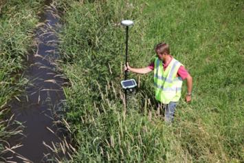
5 Hardware Solutions Shaping change with GIS Asset Collection


 IP54")

6 Leica Zeno GIS series The Leica Zeno 5 Best equipped entry-level GPS handheld Windows Embedded Operating System 3.7 inch VGA sunlight readable touchscreen Ultra-fast 800 MHz with 256 MB RAM Integrated GPS receiver and other sensors 3.8G broadband cellular modem incl. voice and data, Bluetooth and Wireless LAN 3.2 Mega Pixel with Auto Focus & Flash All-day hot-swappable battery (10h) IP54 just 375gr SBAS Accuracy: 1-3 Meters, PP: 1-3 Meters Can be used with GG03 to improve accuracy to centimeter level. Main Use Case Maintenance work Rugged phone for outdoor workers Integrate with enterprise solutions like Optim Mobile or ArcGIS for Windows Mobile


7 Leica Zeno GIS Series Leica Zeno 10 and Zeno 15 The most rugged and versatile GNSS/GIS Handhelds in the market IP67, 1.2m drop, operating temp -30 to +60 C High-Performance sub-meter GNSS/GIS Handhelds 14 channel GPS/Glonass/SBAS receiver with submeter accuracy both real-time and post-processed. Packed with power for outstanding performance Integrated WLAN Integrated 3.5G module 2MPixel integrated camera Re-chargeable and exchangeable batteries with 8-9 h operating time

 Hot-swappable batteries with real 8h+ operating time Integrated GPS (2-5 m) and 5 MP Camera")
8 Leica Zeno GIS series The CS25 plus Leica CS25 plus Light (1.3 kg) & rugged: IP65, C, 1.2m Integrated 3.5G Modem, Bluetooth and WLAN 128 GB SSD, Atom 1.6 GHz & 4GB DDR3 RAM Large (7 ) Touchscreen Windows 7 Ultimate Edition (incl. 34 Language packs) Hot-swappable batteries with real 8h+ operating time Integrated GPS (2-5 m) and 5 MP Camera Outdoor viewable Main Use Case Standalone: QA/QC With GG03: professional, high-accuracy mapping rover


9 Leica CS25 GNSS plus high-accuracy tablet computer Product Overview All you need in one device


10 Leica Zeno GIS series The CS25 GNSS plus Leica CS25 GNSS best accuracy with the largest screen You can use the CS25 GNSS as a handheld device or on the Pole Integrated L1/L2 GNSS board 120 Channels GPS: L1, L2, L2C GLONASS: L1, L2 Beidou: B1, Galileo: E1 5 Hz update rate Accuracy With external Leica AS10: 1 cm With internal Helix Antenna: 10 cm or better Simple click mechanism via QN adaptor - to attach/remove the L1/L2 helix antenna to the CS25 GNSS. The L1/L2 helix antenna can be turned down to store it for transportation without removing it.
 DGNSS Accuracy L1 only: < 50 cm L1/L2: 1 cm + 2 ppm, Best-in class tracking performance in difficult conditions Compatible with any Zeno controller (Zeno 5, CS10, CS15, CS25 plus)")
11 Leica Zeno GIS series The Leica GG03 The most versatile GNSS/GIS receiver for GIS & Mapping tasks 120 channel GNSS SmartAntenna L1 or L1/L2 (Option) GPS & Glonass (Option) Galileo E1 & Beidou B1 1 Hz or 5 Hz (Option) DGNSS Accuracy L1 only: < 50 cm L1/L2: 1 cm + 2 ppm, Best-in class tracking performance in difficult conditions Compatible with any Zeno controller (Zeno 5, CS10, CS15, CS25 plus) Lightweight (0.8 kg) und ultra-rugged: IP68, F Cable free, Re-chargeable/exchangeable batteries Main Use Case L1: Data Collection with sub-meter or better requirements L1/L2: Professional, high-accuracy mapping for e.g. UT Able to pick your field collector based on requirements/needs
12 Software Solutions Shaping change with GIS Asset Collection
 support Basic GIS editing tools Interfaces directly with ArcGIS Shape dxf dwg dgn Simple field and office data transfer EasyOut and EasyIn (includes GNSS post-processing) Interface to")
13 Leica Zeno GIS series Leica Zeno Office Powerful GIS and GNSS Processing Office package The office component to Leica Zeno Field Vector and Raster (incl. georeferencing) support Basic GIS editing tools Interfaces directly with ArcGIS Shape dxf dwg dgn Simple field and office data transfer EasyOut and EasyIn (includes GNSS post-processing) Interface to Leica surveying sensors Also available as an extension to ArcGIS (versions 10, 10.1 or 10.2)
14 Leica Zeno GIS series Leica Zeno Office & Zeno Office on ArcGIS Zeno Office 3.2 is an OEM version of Esri ArcGIS for Desktop version 10 SP5 Zeno Office on ArcGIS 3.2 is currently compatible with ArcGIS for Desktop 10, 10.1, 10.2 Three of each version: Basic (EasyOut/In, QA/QC, reporting, etc.) Advanced (above plus L1 post-processing) Professional (above plus L2 post-processing) Does a customer have Esri ArcGIS for Desktop or plan on purchasing it? No Yes Zeno Office 3.2 Zeno Office on ArcGIS 3.2
 and Raster support DXF import (via Zeno Office) Supported hardware Leica Zeno 5/10/15 & Leica CS25 plus Leica GG03 Camera, Laser rangefinder & DigiCAT Main Use Case Data Collection")
15 Leica Zeno GIS series Leica Zeno Field Simple to use Mapping and Collection Software Based on industry-leading ArcPad 10 Capabilities for capturing, editing, and displaying geographic information Vector (shape) and Raster support DXF import (via Zeno Office) Supported hardware Leica Zeno 5/10/15 & Leica CS25 plus Leica GG03 Camera, Laser rangefinder & DigiCAT Main Use Case Data Collection Data Maintenance

16 Leica Zeno GIS series Leica Zeno Connect With Zeno Connect Software partners can integrate their software with Leica Zeno GNSS/GIS hardware. Leica Zeno Connect can either be used as a standalone application, or can be integrated into 3rd party applications with little effort. Features & Functionality Configure the Leica Zeno GNSS antennas and setup the connection details to use RTK/DGPS (NTRIP, Beacon, SBAS etc.) Connect to a RTK/DGPS stream (radio, internal modem, mobile phone) Stream NMEA data to a COM port to interface with 3 rd party applications Zeno Connect SDK System Integrators can use the Zeno Connect SDK The SDK is made for C++ and C# (incl. a sample code) Current implementations shown an effort of 2-5 days (depending on know-how and integration level) Main Use Case 3rd party software integration/support


17 Leica Zeno GIS series Leica Zeno Connect Zeno Connect would be the perfect tool to combine Leica Zeno hardware with 3 rd party mobile technology. Hexagon Geospatial GeoMedia Hexagon Geospatial Mobile MapWorks Esri ArcPad Esri ArcGIS for Windows Mobile MicroSurvey FieldGenius Carlson SurvPC In-house Developed Mobile Apps Other 3 rd Party Apps

18 Leica Zeno GIS series Leica Optim Desktop for Esri ArcGIS Field Data management at the highest level Download and upload field solutions (including non-spatial tables and imagery) Manual or automatic post-processing Project and device status information Easily install mobile software to Leica hardware Directly connect Optim Studio solutions to current Esri.MXD files for enterprise deployment. Streamlines workflow Main Use Case Intuitive workflow and easy to deploy Great solution for small organizations up to enterprise level organizations

19 Leica Zeno GIS series Leica Optim Mobile Intuitive and easy-to-use mobile software Workflow driven, intelligent forms, configurable without programming efforts Seamless, efficient and fast transfer of tasks and data to and from mobile devices Spatially enabled workflows and reference data in the field where you need them High-accuracy GPS data collection with integration for line locators, laser range finders and barcode readers Seamless data transfer to your GIS environment and relational databases Deployed via desktop or the web Patented high performance web display Direct integration with ArcGIS for Server, web map for transfer of data, auto post-processing, reporting and more. Main Use Case Data Collection Data Maintenance Enterprise GIS Deployments
20 Leica Zeno GIS series Leica Optim Studio Powerful and robust mobile solution configuration tool Directly connect to tables and attributes in GIS and other relational databases (SQL and Oracle) Total control over what subsets of the database transfer to the mobile and back Supports both spatial and non-spatial database tables Relational database support on the mobile device Optimize and modify display settings for specific field use Instant visualization of field data before being deployed Eliminate costly and time-consuming custom development Main Use Case Fast and efficient deployment of GIS data for field use

21 Leica Zeno GIS series Leica Optim Server Web-based deployment for integration of GIS and mobile solutions Mobile data collection solutions and project data directly downloaded to mobile devices and collected data can be uploaded with one click. Automated installation and all projects can be monitored from one central configuration control panel Integrated with Esri ArcGIS for Server View and share data with other users in your organization. Access anywhere via a web browser to review field data collection Main Use Case Easily and efficiently deploy as well as manage field data to an enterprise organization


22 Leica Zeno GIS series Leica MobileMatriX A survey-oriented solution for GIS data collection Multi-Sensor GIS Combining surveying sensors (GNSS, TPS,...) with a field computer like the Leica CS25 Together with a GG03 a light-weight and integrated GNSS all-on-the-pole solution Controlling sensors, Editing, Collecting, Visualisation and Mapping tasks are directly performed in MobileMatriX True Field to Finish GIS Solution Fully integrated into ArcGIS Perfectly suited for National Mapping Agencies, UT & Engineering Companies. Main Use Case Organisations that require survey data collection in GIS, by combining Total Stations and GNSS.


 Scan")
23 Leica Zeno GIS Asset Collection Attribute rich GIS data cm accuracy GIS Asset Collection is much more then simple point, line and feature collection. Simple in the field, all managed by the defined data model back in the office GIS. Geometry Attributes Behaviour & Rules Images (Barcode) Scan Authoritative data where decisions matter


24 Leica Zeno GIS Series Optimised for GIS asset collection 1cm 30 cm Scalable to fit your needs Accurate & Precise Optimised tracking in demanding environments Rugged & Reliable Fast & Efficient

25 User Stories Shaping change with GIS Asset Collection

26 Leica Zeno GIS Asset Collection Case Studies: CoServ Customer: CoServ Electric Challenge: Enterprise GIS serving over 180,000 customers in North Texas, mapping electrical features over entire coverage area Equipment: 40 Zeno 5 Units + Zeno Office on ArcGIS + Zeno Field


27 Leica Zeno GIS Asset Collection Case Studies: Montgomery County, MD Highway Services Customer: Montgomery County, MD Highway Services Dept. Challenge: Enterprise GIS field mapping, work orders, integration with 3 rd party accounting software. Equipment: 10 CS25 GNSS plus + Optim Enterprise + Professional Services
28 Leica Zeno GIS Asset Collection Case Studies: Dawson Geophysical Customer: Dawson Geophysical Challenge: Accurate mapping of features as well as potential field hazards related to seismic mapping. Equipment: ~30 CS25 GNSS & CS25 GNSS plus + Zeno Field + Zeno Office on ArcGIS

29 Leica Zeno GIS Asset Collection Case Studies: Rural Payment Agency (UK) Customer: Rural Payment Agency (UK) Challenge: Standardized on Leica Zeno GIS series for subsidising rural communities UK wide Equipment: 222 x CS25 GNSS + Zeno Field + Zeno Office + managed service
.")
30 Leica Zeno GIS Asset Collection Case Studies: ARiMR (Poland) Customer: ARiMR (Agency for Restructuring & Modernisation of Agriculture) Equipment: 155 x GG03 Basic + Zeno Connect (with QGIS) + Getac tablet Challenge ARMA is using the Leica GG03 GNSS SmartAntenna for validation of areas for EU subsidies (on-site control of land size and cultivation). Benefits Checks are based on parcel size measured by GPS and on-site of cultivated crops / crop group Those data cannot be measured in the orthophoto (too small and difficult to see, e.g. in the shade of the trees). Quick method to check if beneficiaries give true information Why Leica GG03? Before ARMA was using GPS from Trimble and CHC (China). Better accuracy then in the past Easiest integration into QGIS via Zeno Connect Upgrade to L1/L2 w/o changing the HW

31 Leica GIS Asset Collection & Management Professional Services A full service geospatial provider Consulting Database Design Data Maintenance Workflow & Integration Server Installation & Configuration Customization On-site and Web-based Training
, web-based support The more details you provide the faster the issue can be resolved Dealer/Distribution Parnter Leica US: GIS Support Leica Heerbrugg: GIS Support Leica GIS Product")
32 Technical Support Assisting customers every step of the way Direct support from Leica Geosystems Clear and open lines of communication Phone, web-based support The more details you provide the faster the issue can be resolved Dealer/Distribution Parnter Leica US: GIS Support Leica Heerbrugg: GIS Support Leica GIS Product Management Leica Heerbrugg: Dev Team
33 Leica Zeno GIS series Conclusion Known for our measurement capabilities.ability to provide any accuracy for any application through scalable and flexible hardware and software solutions Not locked into GIS only solutions, ability to add other applications Leica Geosystems brings a storied history of market-leading innovations A brand built around product ruggedness and usability in all conditions Established team of professionals to best assist customers in the geospatial field Limitless resources to assist customers implement solutions that best fit the organizations needs Continued dedication to improving hardware and software offerings Not just providing hardware and software, Leica Geosystems is providing accurate and efficient solutions.

34 Leica GIS Asset Collection & Management Questions and Comments Please let me know, if you have any questions and comments. 34
Shaping the World with Leica Zeno GIS Asset Collection & Management
 Shaping the World with Leica Zeno GIS Asset Collection & Management Edward Toh GIS Segment Manager, APAC Agenda Power of Geography Location bring values Case Studies Integration of Surveyors into GIS Leica
Leica Zeno 20 More than GPS
 Leica Zeno 20 More than GPS TECHNOLOGIES Leica Zeno 20 does so much more The Leica Zeno 20 is much more than just GPS it is a fusion of great technologies. Powerful and easy, it s the ultimate geospatial
Release 4.1. Description
 Leica MobileMatriX Release 4.1 Products - Options Packages - Hardware Description Leica MobileMatriX 4.1 Leica Geosystems, 2004-2010 1 PRODUCTS Three different Editions are available: Standard Edition
GEOGRAPHIC INFORMATION SYSTEMS (GIS)
") GEOGRAPHIC INFORMATION SYSTEMS (GIS) MobileMaper 120 MobileMaper 10 A Geographic Information System (GIS) is a system designed to capture, store, manipulate, analyze, manage, and present geographic data
GEOGRAPHIC INFORMATION SYSTEMS (GIS) MobileMaper 120 MobileMaper 10 A Geographic Information System (GIS) is a system designed to capture, store, manipulate, analyze, manage, and present geographic data
Leica Zeno GIS Equipment List
 Leica Zeno GIS Equipment List Table of Contents 1 Leica Zeno 10/Zeno 15 - GNSS/GIS Handhelds 3 2 GNSS Caps GS05 and GS06 for CS10 GIS & CS15 GIS 3 3 Packages 3 4 Additional Leica Zeno 10/Zeno 15 Options
Geospatial Data Collection
 Geospatial Data Collection Etienne Coetzee Regional Manager: Africa OPTRON at a glance Established in 1986, Trimble dealer since 1987 Offices(6) in Centurion, Cape Town, Somerset-West, Durban, Nairobi
NAUTIZ X3 POCKET-SIZED POWERHOUSE
 Windows or Android NAUTIZ X1 BUILT TO SURVIVE The Nautiz X1 is an ultra-rugged handheld that breaks through barriers of size, toughness and reliability. With its slim size and light weight it s in a class
New trends of GIS terrain mapping with modern low cost GNSS technology
 New trends of GIS terrain mapping with modern low cost GNSS technology Tomáš Bláha / Magellan Professional Sales Manager Eastern Europe DATECS GIS Conference, March 27, 2009, Sofia Hotel Holiday Inn 1
ESRI Mobile GIS Solutions Overview. Justin Fan
 ESRI Mobile GIS Solutions Overview Justin Fan Agenda Mobile GIS challenges ESRI Mobile GIS solutions ArcPad ArcGIS Mobile ArcGIS Engine Selecting a mobile GIS solution Q & A Objective To help you select
Notice Inviting Quotations
 From Chairperson, Department of Geography, Centre of Advanced Study Panjab University, Chandigarh. To Notice Inviting Quotations No Geog/986 Dated : 12.09.14 Dear Sir, Please quote Technical and Financial
trimble gnss surveying systems
 trimble gnss surveying systems TRIMBLE GNSS SYSTEMS: SOLVING YOUR CHALLENGES IN THE FIELD INDUSTRY-LEADING GNSS SOLUTIONS DESIGNED WITH THE SURVEYOR IN MIND Backed by a legacy of GNSS technology surveying
Geospatial GNSS Systems TRANSFORMING THE WAY THE WORLD WORKS
 Geospatial GNSS Systems GNSS Solutions Designed with the Surveyor in Mind POWERFUL TECHNOLOGY YOU CAN DEPEND ON NO MATTER WHAT THE CHALLENGE Whether you are climbing over rough terrain to collect topographic
Trimble Mobile Mapping Portfolio
 Jörg Amend Sales Account Manager SEPTEMBER 20 2017 Trimble Mobile Mapping Portfolio Current challenges and trends Multible Sensors connecting to one Echosystem Trimble RealWorks Trimble Edgewise TBC Pathfinder
trimble gnss surveying systems
 trimble gnss surveying systems TRIMBLE GNSS SYSTEMS: SOLVING YOUR CHALLENGES IN THE FIELD INDUSTRY-LEADING GNSS SOLUTIONS DESIGNED WITH THE SURVEYOR IN MIND Backed by a legacy of GNSS technology surveying
Bag Lifting Tethering Crane Lifting Debogging Transport. No. 2: Customized package
 Recovery Manager Software All recovery methods in one software Your next recovery will be much smoother with SefrinTec. SefrinTec s perfect interaction between the pressure-sensitive sensors inside the
ArcPad 10 for Mobile GIS
 ArcPad 10 for Mobile GIS Electronic Data Solutions Jackson Beighle & Alison Walker 10/27/10 Workshop Agenda 1:30 2:00 What s new at ArcPad 10? 2:00 2:30 Hardware and Software Options for Mobile GIS 2:30
Tablet PC System Solution
 Tablet PC System Solution ENTERPRISE MOBILITY INTERCONNECT, PROTECT, OPTIMIZE Communication and collaboration in hazardous areas become increasingly important. Cameras, smartphones and tablet PCs which
Trimble S6. General. The Trimble S6 Total Station provides the power and flexibility required by today\'s surveying professionals.
 Trimble S6 General Product Description Product Brochure The Trimble S6 Total Station provides the power and flexibility required by today\'s surveying professionals. /upload/165-868-5836.pdf Demonstration
GateSea Technology 2017
 GateSea Technology 2017 Solar Powered Security Camera System Zhongshan GateSea Technology Co., Ltd Website: www.sunwebcam.com Mobile:+ 86 760 87808163 Email:info@sunwebcam. com Address: Block NO.9,E- PARK,South
BIM & Digital Transformation Scotland Live 2018 Capturing 3D Reality at the push of a button
 BIM & Digital Transformation Scotland Live 2018 Capturing 3D Reality at the push of a button Gary Kelly Country Manager Scotland Leica Geosystems @LeicaScot Capturing 3D Reality at the push of a button
Topcon GRS-1 1 Receiver Field Preparation
 Topcon GRS-1 1 Receiver Field Preparation What do you need to know to get started with your Topcon GRS-1? Topcon GRS-1 Receiver - Field Preparation Some Common Questions Which TopSURV modules do I buy?
MobileMapper CX. Map anything. Anywhere. In any way.
 MobileMapper CX Map anything. Anywhere. In any way. A Universal GIS Solution MobileMapper CX MobileMapper CX is a highly flexible, accurate, affordable and rugged handheld GPS receiver for universal GIS
Trimble Business Center Software, v3.30
 Trimble Business Center Software, v3.30 We are pleased to announce a new version of the Trimble Business Center software, version 3.30. This new version includes over 30 new features and enhancements increasing
TECHNOLOGY SOLUTIONS TRANSFORMING CONSTRUCTION LAYOUT. Trimble Field Link TRANSFORMING THE WAY THE WORLD WORKS
 TECHNOLOGY SOLUTIONS TRANSFORMING CONSTRUCTION LAYOUT Taking full advantage of the Trimble Tablet s processor and multi-touch screen functionality, has been designed to work the way you work. Featuring
Iwane Mobile Mapping System
 Iwane Mobile Mapping System Geo-Imaging Mobile Mapping Solution Iwane Mobile Mapping System (IMMS) is high-efficient, easyto-use, end-to-end solution that provides tremendous flexibility in collecting,
Trimble GeoCollector for ArcGIS: An Introduction. Morgan Zhang (Esri), Matthew Morris (Trimble)
, Matthew Morris (Trimble)") Trimble GeoCollector for ArcGIS: An Introduction Morgan Zhang (Esri), Matthew Morris (Trimble) Overview Introduction to mobile GIS Overview of ArcGIS for Windows Mobile Overview of Trimble Positions software
Trimble GeoCollector for ArcGIS: An Introduction Morgan Zhang (Esri), Matthew Morris (Trimble) Overview Introduction to mobile GIS Overview of ArcGIS for Windows Mobile Overview of Trimble Positions software
Introducing. GeoSLAM. The experts in go anywhere 3D mobile mapping technology. The Company. The Technology. The Applications. Strategic Partnerships
 Introducing GeoSLAM The experts in go anywhere 3D mobile mapping technology The Company The Technology The Applications Strategic Partnerships The Company Multipurpose Presentation Template 2 About Us
GNSS/GIS DATA COLLECTION SOFTWARE
 GNSS/GIS DATA COLLECTION SOFTWARE Product Overview // July 2018 EZTAG CE SOFTWARE Designed for highly productive field GIS data collection EZTag CE TM software is designed to collect simple or complex
GeoMax GNSS ZGP800 Series. Works when you do
 GeoMax GNSS ZGP800 Series Works when you do GeoMax About Us GeoMax is an internationally active company developing, manufacturing and distributing quality surveying instruments. We provide a comprehensive
Introduction to ArcPad
 Introduction to ArcPad Jennifer McKee Prepared by: With support from: NSF DUE-090270 in partnership with: Mobile GIS Allows field staff to capture, update, analyze spatial data Extends reach of the office
Construction Survey GIS. Doug Kotnik, GISP
 Construction Survey GIS Doug Kotnik, GISP Construction Survey GIS Sales Service Rentals Training Support Products & Services Authorized Dealer Trimble, Spectra Precision, Nikon, & Ashtech Authorized Warranty
8 Features Every Mobile E-Ticketing Device Needs. Finding the right tool for the job.
 8 Features Every Mobile E-Ticketing Device Needs Finding the right tool for the job. 1 8 Features Every Mobile E-Ticketing Device Needs Finding the right tool for the job. Having the right tool for the
2012 Product Catalogue
 It s Professional 2012 Product Catalogue FOIF Canada Inc. 4180 Boul. Thimens Saint-Laurent, QC, H4R 2B9, Canada Tel: +1 (514) 336-0003 Fax: +1 (514) 336-0300 Email: info@foif.ca Web: www.foif.ca 2 2012
The Most Comprehensive Solution for Indoor Mapping Applications
 The Most Comprehensive Solution for Indoor Mapping Applications TRIMBLE INDOOR MOBILE MAPPING SOLUTION TRIMBLE INDOOR MOBILE MAPPING SOLUTION (TIMMS): HIGH EFFICIENCY, MAXIMUM FLEXIBILITY, ALL-IN-ONE PACKAGE
Hardware 3D Mapping Systems
 Hardware 3D Mapping Systems About Us GreenValley International GreenValley International provides 3D mapping solutions that include mobile & aerial LiDAR acquisition hardware, post-processing software
User Manual For TX204B/TX204G/TX306 Receivers
 User Manual Version V1.0-20171124 User Manual For TX204B/TX204G/TX306 Receivers 2017 Tersus GNSS Inc. All rights reserved. Sales & Technical Support: sales@tersus-gnss.com & support@tersus-gnss.com More
Trimble VISION Positions from Pictures
 Trimble VISION Positions from Pictures This session will cover What Is Trimble VISION? Trimble VISION Portfolio What Do you Need? How Does It Work & How Accurate Is It? Applications Resources Trimble VISION
Our Challenge : To manage an increasingly complex world!
 SmartPhones Our Challenge : To manage an increasingly complex world! The Leica Response: To enable the capture, and virtualisation of this complex world quickly, easily and accurately New hardware and
Enterprise Geographic Information Servers. Dr David Maguire Director of Products Kevin Daugherty ESRI
 Enterprise Geographic Information Servers Dr David Maguire Director of Products Kevin Daugherty ESRI Outline Introduction Enterprise GIS vs. Spatially-enabled IS Architectures for building Enterprise GIS
Trimble Positioning for Automotive Applications
 Trimble Positioning for Automotive Applications Trimble at a Glance Core Markets Agriculture Construction Building Construction Geospatial Transportation Emerging Markets Automotive Rail A MARKET LEADER
Sleek yet Semi-rugged! BM-170. Enterprise Handheld PDA. Handheld
 Sleek yet Semi-rugged! BM-170 Enterprise Handheld PDA Handheld BM-170 Enterprise Handheld PDA INDUSTRIES Education Retail Public Transport Hospitality Healthcare BM-170 enterprise handheld PDA presents
The Zebra DsD/rouTe accounting Mobile computing portfolio Zebra Technologies
 The ZEBRA DSD/Route Accounting Mobile Computing Portfolio The ZEBRA DSD/Route Accounting Regardless of how simple or complex your DSD/route accounting applications are or how demanding the environment
Implementing ArcGIS Mobile Applications for the Enterprise
 Implementing ArcGIS Mobile Applications for the Enterprise Myles Sutherland Glenn Meister ESRI Developer Summit 2008 1 Schedule 75 minute session 60 65 minute lecture 10 15 minutes Q & A following the
LT30 GETTING STARTED GUIDE GPS/GIS HANDHELD CONTROLLER
 LT30 GETTING STARTED GUIDE GPS/GIS HANDHELD CONTROLLER Copyright Copyright 2009-2012 CHC Shanghai HuaCe Navigation Technology Ltd. All rights reserved. The CHC are trademark of Shanghai Huace Navigation
Trimble MX2 mobile mapping
 Trimble MX2 mobile mapping user applications Point clouds within your reach The Trimble MX2 is a vehicle-mounted spatial imaging system which combines high resolution laser scanning and panoramic cameras
General Dynamics Itronix GD3015 Semi-Rugged Tablet
 General Dynamics Itronix Semi-Rugged Tablet The semi-rugged tablet from General Dynamics Itronix delivers the full functionality of a notebook with the critical components and options mobile professionals
New Product - Trimble Juno 5 JUNO 5: Now Shipping
 EW N Your Mapping/GIS technology partner Mapping / GIS Newsletter Issue: 1 - January 2013 In This Edition New Product - Trimble Juno 5 JUNO 5: Now Shipping RFID Ball Marker Technology Trimble Juno 5 series
ArcPad An Introduction
 ArcPad An Introduction Chris LeSueur, Marika Vertzonis, Hannah Ferrier ArcPad Sessions at the UC Demo Theatre - Preparing and Deploying Data to ArcPad - Using ArcPad in the Field - Customizing ArcPad without
Trimble UAS Portfolio Update. August 25 th 2015
 Trimble UAS Portfolio Update August 25 th 2015 Trimble UAS Portfolio Updates Trimble UX5 Setting the Standard in Mapping Trimble UX5 HP High Precision Surveying and Mapping Solution Trimble ZX5 Flexible
Data Communication Products section 6
 Data Communication Products section 6 July 2014 Section 6 1 Data Communication Products section 6 Features High-Speed HF Modem Fax, Image and E-mail System Embedded & Standalone Systems Automatic Message
RealWorld RealCity RealTerrain Airborne Reality Capture The Integral World of Leica Airborne Solutions
 RealWorld RealCity RealTerrain Airborne Reality Capture The Integral World of Leica Airborne Solutions Photogrammetric Week, September 11, 2017 Dr. Hartmut Rosengarten, Director Airborne Solutions EMEA,
 telensa.com @Telensa Telensa is the only firm monetizing multiple IoT applications including smart lighting and smart parking. We deliver ultra-scalable, private network solutions through Ultra Narrow
Overview of the Trimble TX5 Laser Scanner
 Overview of the Trimble TX5 Laser Scanner Trimble TX5 Revolutionary and versatile scanning solution Compact / Lightweight Efficient Economical Ease of Use Small and Compact Smallest and most compact 3D
Features C U. 1 x Micro HDMI 1 x Micro USB 2.0 (host and charging) 1 x Micro SIM
 1 x Micro SIM") AIM-35 8" Industrial Tablet for Retail Application Powered By Intel Atom Processor Intel Atom processor for Windows 10 IoT and Android 6.0 operating systems Industrial-Grade 8" 1,920 x 1,200 LCD Panel
AIM-35 8" Industrial Tablet for Retail Application Powered By Intel Atom Processor Intel Atom processor for Windows 10 IoT and Android 6.0 operating systems Industrial-Grade 8" 1,920 x 1,200 LCD Panel
Features C U. 1 x AIM dock 16-pin pogo connector: 1 x USB 3.0, 9V power 1 x Power Buttons
 AIM-65 8" Industrial-Grade Tablet with Intel Atom Processor Intel Atom processor for Windows 10 IoT and Android 6.0 operating systems 8" WUXGA full HD display with scratch-resistant Corning Gorilla Glass
ArcPad An Introduction
 2013 Esri International User Conference July 8 12, 2013 San Diego, California Technical Workshop ArcPad An Introduction Chris LeSeuer, Marika Vertzonis, Hannah Ferrier Esri UC2013. Technical Workshop.
Awaken Your Inner GIS Solution. The webcast will begin at 10:01 AM (MDT)
") Awaken Your Inner GIS Solution The webcast will begin at 10:01 AM (MDT) Presenter Bios Paul Adkins MarCom Manager Laser Technology, Inc. Derrick Reish Sr. Product Manager Professional Measurement Laser
Awaken Your Inner GIS Solution The webcast will begin at 10:01 AM (MDT) Presenter Bios Paul Adkins MarCom Manager Laser Technology, Inc. Derrick Reish Sr. Product Manager Professional Measurement Laser
GNSS/GIS DATA COLLECTION SOFTWARE
 GNSS/GIS DATA COLLECTION SOFTWARE Product Overview // August 2014 EZTAG CE SOFTWARE Designed for highly productive field GIS data collection EZTag CE TM software is designed to collect simple or complex
2016 STUDY TOP SIX PRIORITIES FOR TEAM COMMUNICATIONS
 2016 STUDY TOP SIX PRIORITIES FOR TEAM COMMUNICATIONS SURVEY OVERVIEW The 2016 Motorola Commercial Survey offers revealing insights into team communication trends in a variety of industries across the
YOUR VISION OUR POWERFUL LE1700 TABLET PC. The Motion LE1700 is powered by the Intel Core 2 Duo processor.
 YOUR VISION OUR POWERFUL LE1700 TABLET PC The Motion LE1700 is powered by the Intel Core 2 Duo processor. Powerful Technology. unmatched Performance. ultimate Mobility. LE1700 Tablet PC from Motion Computing.
Trimble Field Solutions in Surveying
 Trimble Field Solutions in Surveying Trimble Survey Controllers and Field Software A total approach to managing fieldwork. RELEASE THE FULL POTENTIAL OF YOUR SURVEYING GEAR AND YOUR BUSINESS Trimble controllers
HANDHELD MOBILE MAPPING / 3D LASER MAPPING SOLUTIONS. ZEB Family Brochure. geoslam.com
 HANDHELD MOBILE MAPPING / 3D LASER MAPPING SOLUTIONS ZEB Family Brochure geoslam.com NEW Long range, greater intensity, UAV ready HANDHELD BACKPACK UAV Effortless Data Capture Your tool to capture, view
Collecting Data on your Phone or Tablet. Tyler Gakstatter Resource Supply LLC Lake Oswego, OR
 Collecting Data on your Phone or Tablet Tyler Gakstatter Resource Supply LLC Lake Oswego, OR Who can benefit from using smartphones and tablets? One-man show to large field crews. Create maps and push
ICIT. Brian Hiller ESRI Account Manger. What s new in ArcGIS 10
 ICIT Brian Hiller ESRI Account Manger What s new in ArcGIS 10 ArcGIS 10 Fast Easy Powerful Everywhere late June 2010 ArcGIS System for Geographic Information Desktop Server Mobile Online A System A Complete
IP-S2 HD. High Definition 3D Mobile Mapping System
 IP-S2 HD High Definition 3D Mobile Mapping System Integrated, turnkey solution Georeferenced, Time-Stamped, Point Clouds and Imagery High Density, Long Range LiDAR sensor for ultimate in visual detail
A2200-A. Application: Handheld Device Vehicle tracking
 A2200-A This small form-factor module fully addresses the demand for lowest power consumption with, amongst other features, SiRFaware technology. The removal of jammers does not only facilitate designs
Surface Go for Education
 Surface Go for Education Unlock limitless learning with Surface Go Spark creativity in students with Surface Go, a powerful, versatile device that s great for education and exploration. As versatile as
Features C U. 1 x AIM dock 16-pin pogo connector: 1 x USB 3.0, 9V power 1 x Power Buttons
 AIM-65 8" Industrial-Grade Tablet with Intel Atom Processor Intel Atom processor for Windows 10 IoT and Android 6.0 operating systems 8" WUXGA full HD display with scratch-resistant Corning Gorilla Glass
IMAGERY FOR ARCGIS. Manage and Understand Your Imagery. Credit: Image courtesy of DigitalGlobe
 IMAGERY FOR ARCGIS Manage and Understand Your Imagery Credit: Image courtesy of DigitalGlobe 2 ARCGIS IS AN IMAGERY PLATFORM Empowering you to make informed decisions from imagery and remotely sensed data
Sleek yet Semi-rugged! BM-170. Enterprise Handheld PDA. Handheld
 Sleek yet Semi-rugged! BM-170 Enterprise Handheld PDA Handheld BM-170 Enterprise Handheld PDA INDUSTRIES Education Retail Public Transport Hospitality Healthcare BM-170 enterprise handheld PDA presents
Support cloud-based integration
 M2M series Driving the Future of Mission-Critical and M2M Innovation Support cloud-based integration M2 M Transport & Telematics Fleet Management We provide a total monitoring solution with On-Board Diagnostics
GeoSLAM Overview. The experts in go-anywhere 3D mobile mapping technology
 GeoSLAM Overview The experts in go-anywhere 3D mobile mapping technology 1 About GeoSLAM The experts in go-anywhere 3D mobile mapping technology 2 Who We Are GeoSLAM is a global market leader in go-anywhere
Excellence Assured Accelerate your business potential with innovative IT Services
 Excellence Assured 0113 244 5150 Info@instate.co.uk Accelerate your business potential with innovative IT Services In an increasingly pressured business environment, we offer our customers quality technology
Features C U. Intel Atom x7-z8750 quad-core, 1.6 Ghz (2M cache, up to 2.56 Ghz) System
 System") AIM-38 10.1" Industrial Tablet for Retail Application Powered by Intel Atom Processor Intel Atom processor for Windows 10 IoT & Android 6.0 operating systems 10.1" WUXGA full HD display with scratch-resistant
AIM-38 10.1" Industrial Tablet for Retail Application Powered by Intel Atom Processor Intel Atom processor for Windows 10 IoT & Android 6.0 operating systems 10.1" WUXGA full HD display with scratch-resistant
Global Tracking. Personal Tracker and Messenger Connect with Your Workers Anywhere in the World
 Global Tracking Personal Tracker and Messenger Connect with Your Workers Anywhere in the World Connect With Your Workers Anywhere in the World. When the safety of your personnel is at stake especially
OMNII RT15 - THE BEAUTIFULLY RUGGED HANDHELD FOR FIELD WORKERS
 OMNII RT15 - THE BEAUTIFULLY RUGGED HANDHELD FOR FIELD WORKERS The new Omnii RT15 is the result of requests for a sleeker, customer-facing device that s rugged enough to handle unforgiving field environments.
Convergence Everywhere
 Convergence Everywhere Gregory J Hill FEBRUARY 2016 PHOENIX, AZ Why Convergence? APPLICATIONS Rapid proliferation and demand data from many systems Supporting diverse range of technologies Streaming video,
Forest Technology: Apps, Maps, Phones, and Drones
 Forest Technology: Apps, Maps, Phones, and Drones TFA Annual Meeting 2018 Darian Yawn LandMark Spatial Solutions, LLC Forest Technology Company Sales, Training, Support GIS Consulting, Repairs, Rentals
Rugged All-in-one Handheld Computer. BIP-1500 Series
 Rugged All-in-one Handheld Computer BIP-1500 Series BIP-1500 Series INDUSTRIES Retail Public Transport Hospitality Finance The rugged all-in-one handheld computer, BIP-1500 Series, is designed to meet
2/9/2016. Session Agenda: Implementing new Geospatial Technologies for more efficient data capture
 Implementing new Geospatial Technologies for more efficient data capture Jay Haskamp Applied Geospatial Engineer Steve Richter VP Sales Session Agenda: Today s changing technologies and what lies ahead
P. O. Box 31, Jerome, ID Ph: (208) Fax: (208)
 Fax: (208)") This document describes the new features included in versions of the Trimble Positions Mobile Extension software since version 3.1.0 was released. The new features are reported relative to the previous
This document describes the new features included in versions of the Trimble Positions Mobile Extension software since version 3.1.0 was released. The new features are reported relative to the previous
GeoMax TPS family. Works when you do.
 Works when you do GeoMax TPS family GeoMax has a complete TPS portfolio to fulfill the needs of all users. Ensure ultimate reliability with GeoMax TPS systems even in challenging environments. Providing
NETCOMM WIRELESS M2M INDUSTRIAL M2M DEVICES. July 2012
 NETCOMM WIRELESS M2M INDUSTRIAL M2M DEVICES July 2012 NETCOMM WIRELESS OVERVIEW Founded in 1982 30 years experience Publicly listed on the Australian Stock Exchange (ASX: NTC) A leading supplier of data
MobileMapper Pro. See What's Possible!
 MobileMapper Pro See What's Possible! Mobile Mapping Made Easy MobileMapper Pro Industrial Strength Mapping Solution MobileMapper Pro combines professional GIS data collection and navigation software in
Enhancing through. Panasonic Solutions Company
 Enhancing Government through Innovative Technology Introducing the number-one choice when success is the only option (PSC) brings together four business product divisions, including Panasonic s leading
MobileMapper 300 Frequently Asked Questions
 November 19 th, 2014 MobileMapper 300 Frequently Asked Questions What is the main application of MobileMapper 300? MobileMapper 300 provides professional grade accuracy to consumer handheld devices. A
Simplicity is the new black: The BLK360 story
 Simplicity is the new black: The BLK360 story Vanda KADLECIKOVA Leica Geosystems Heerbrugg, Switzerland E-mail: vanda.kadlecikova@leica-geosystems.com Abstract Meet the game changer. The new Leica BLK360
Rugged Computing Range
 Rugged Computing Range A leader in the global ICT Industry, MiTAC International Corp. was founded in 1982, and designs and manufactures awardwinning technology products for the automotive, enterprise,
ruggpad PM Full Rugged Windows Pad V0.2
 ruggpad PM-522 10.4 Full Rugged Windows Pad 08.20. 2014 V0.2 Content Introduction Product - Outlook - Features - Specification - Accessory Application and Scenario Competitiveness Introduction RuggON PM-522
Leica FlexLine TS06plus Top precision meets high efficiency
 Leica FlexLine TS06plus Top precision meets high efficiency The First Plus: Original Leica Geosystems quality For most, quality is relative. Not so at Leica Geosystems. To ensure our instruments meet the
Fax: +30 (210) Tel Fax
 Tel Fax") Athens Office Cairo Office I.C. Systems S.A. I.C. Systems Ltd 49 Amaroussiou Ave 23 Al-Saad-Al-Alee St. 141 23 Lykovryssi, Athens- Greece 11431, Sarayat, Maadi Tel. +30 (210) 61-07-369 Cairo-Egypt Fax:
Athens Office Cairo Office I.C. Systems S.A. I.C. Systems Ltd 49 Amaroussiou Ave 23 Al-Saad-Al-Alee St. 141 23 Lykovryssi, Athens- Greece 11431, Sarayat, Maadi Tel. +30 (210) 61-07-369 Cairo-Egypt Fax:
Supergeo Webinar. Boost Your Field Productivity & Accuracy with SuperGIS Mobile Solutions. March 25, 2015
 Supergeo Webinar Boost Your Field Productivity & Accuracy with SuperGIS Mobile Solutions March 25, 2015 1 Presenters Olivia Lin Tech Support Engineer GIS Training & Support Center Sarah Liu Sales and Marketing
Trimble Indoor Mobile Mapping Solution
 Kevin Perkins Applanix Corp. NATIONAL SURVEYING, MAPPING & GEOSPATIAL CONFERENCE - MARCH 13-17, 2017 Trimble Indoor Mobile Mapping Solution Why Indoor Mapping? The need: As-built maps/models of indoor
Features C U. 1 x AIM dock 16-pin pogo connector: 1 x USB 3.0, 9V power 1 x Power Buttons
 AIM-65 8" Industrial-Grade Tablet with Intel Atom Processor Intel Atom processor for Windows 10 IoT and Android 6.0 operating systems 8" WUXGA full HD display with scratch-resistant Corning Gorilla Glass
UAS for Surveyors. An emerging technology for the Geospatial Industry. Ian Murgatroyd : Technical Sales Rep. Trimble
 UAS for Surveyors An emerging technology for the Geospatial Industry Ian Murgatroyd : Technical Sales Rep. Trimble Project Overview Voyager Quarry, located near Perth Australia Typical of hard rock mines,
Leica GR25 Don t think Receiver, think Reference Server
 Leica GR25 Don t think Receiver, think Reference Server Leica GR25 GNSS Reference Server Think Reference Server The GR25 is more than just a reference receiver, it is a GNSS Reference Server. Just like
Leica FlexLine TS09plus Full Precision at High Performance
 Leica FlexLine TS09plus Full Precision at High Performance The First Plus: Original Leica Geosystems Quality For most, quality is relative. Not so at Leica Geosystems. To ensure our instruments meet the
Next Generation Networks Powering 5G and the Industrial Internet of Things
 Next Generation Networks Powering 5G and the Industrial Internet of Things Ligado Networks Market Vision At Ligado Networks, our mission is to accelerate digital transformations and modernize American
The Neutron Series Distributed Network Management Solution
 Datasheet The Neutron Series Distributed Network ment Solution Flexible, Scalable, Enterprise-Class ment for Networks Both Large and Small Today s networks must be flexible, robust and as effective as
Emergency Response Network Design & Deployment
 Emergency Response Network Design & Deployment Improving public service communication via a secure, standards-based network Case Study Edward W. Suor, Managing Director VPN Systems, Inc. 2008 100 Carlson