Philip J. Meis, M.S., P.E., M.ASCE Chair
|
|
|
- Felicity Mills
- 5 years ago
- Views:
Transcription


1 Establishing ASCE Standard Consensus Activity for Utility As-Built Records Philip J. Meis, M.S., P.E., M.ASCE Chair


2 Utility As-Built Standard Overview Background and Need Scope Committee Members Schedule

3 Utility As-Built Standard Newly installed or exposed underground utility infrastructure and related appurtenances at or below grade. Users: public land managers and right of way agencies (e.g., federal, state, county and city governments), owners of private industry and land developments, engineers, land surveyors, contractors, and owners of utility infrastructure.


4 Background Nearly all agencies granting permits mandate permittees (i.e., facility owners) to provide upon request accurate utility record information for permitted installations. Not all agencies, however, have a standard process for acquiring or a standard format for submitting the information.

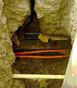
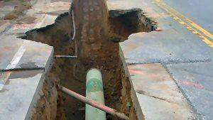
5 Background Accordingly utility records are largely: at an inventory / schematic level not tied to a common spatial datum of inconsistent data quality and content in formats often incompatible for sharing or referencing into CADD or viewing platforms commonly utilized by agencies in charge of granting easements and managing the properties through which these easements pass
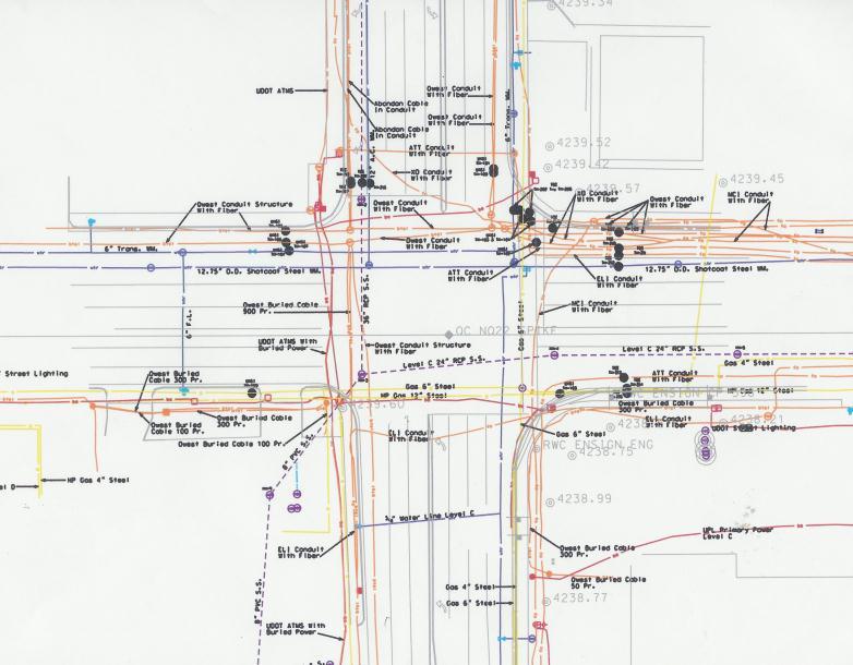
6 Utah DOT As-Built Example
7 Increasing Risk The implications of poor utility records are far reaching and directly impact the public through: 1. rising risk and costs for civil projects and private developments; 2. increased costs for utility infrastructure relocation activities; and 3. worker and public safety issues. Risk is exacerbated by increasingly severe implications caused by disrupting public and commerce overwhelming dependence on web services.


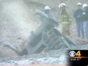
8 Need Utility congestion at problematic levels within public roadway corridors.


9 Increasing Congestion Population growth Public preference for buried cables Utility deregulation Rise in internet usage and dependence e-commerce boon cloud data management
10 Web Use ecommerce Banking, Securities, Stocks Business Ops (Accounting, , file) News, Entertainment, Social Networking Telecommunications / Cellular Services Advertisement / Marketing GPS-Map / GIS Services Education Data Management Services

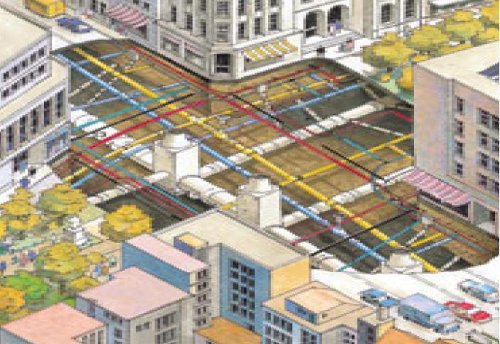


11 Need Utility congestion at problematic levels within public roadway corridors.
12 Scope Develop a new standard for the collection and submittal of utility as-built records and publish as an ASCE non-mandatory consensus standard. Stem from: CI/ASCE & CSA S International Organization for Standardization (ISO) Open Geospatial Consortium (OGC) Federal Geographic Data Committee (FGDC) American National Standards Institute (ANSI) National Oceanic and Atmospheric Administration (NOAA) / National Geodetic Survey (NGS) of the U.S. Department of Commerce Pipeline Open Data Standard (PODS) American Society of Mechanical Engineers (ASME)
13 Participating Organizations American Association of State Highway and Transportation Officials U.S. DOT Pipeline and Hazardous Materials Safety Admin. / FHWA U.S. Army Corps of Engineers and U.S. Navy U.S. NOAA National Geodetic Survey Research - Virginia Tech, TTI Pipeline Open Data Standard (PODS) Construction Industry Design and SUE Consultants Survey & Mapping Industries GIS & CADD Industries Utility Industry Telecomm, Natural Gas, Power, PW


14 Schedule The committee is established and approved by the ASCE Codes and Standards Committee. The committee should be able to develop, review and finalize the standard for the first balloting by the end of 2016.
15 Thank You for Your Interest! For additional Information: Philip J. Meis, M.S., P.E., M. ASCE Chair - Utility As-Built Committee Vice President, Utility Mapping Services, Inc. p c pjmeis@umsi.us
5-0 Mapping Best Practices
 5-0 Mapping Best Practices 5 Mapping 5-0 Mapping Best Practices 5-1: One-Call Center Responsibilities and Use of Mapping Practice Statement: The land base used by the One-Call Centre mapping system should
AD-SDI DATA CONTENT STANDARD
 AD-SDI DATA CONTENT STANDARD UTILITY TELECOM Version 1.0 March 2009 Prepared by Abu Dhabi Systems and Information Centre (ADSIC) Abu Dhabi, UAE REVISION HISTORY Revision # Reason Effective Date 1 Original
Proposed Resolution Joint Technical Committee on Electronic Engineering Data Title: Endorsement of TransXML
 Proposed Resolution Joint Technical Committee on Electronic Engineering Data Title: Endorsement of TransXML WHEREAS, Advancements in technology are providing increasing opportunities and needs for the
FIBER OPTIC RESOURCE SHARING IN VIRGINIA
 FIBER OPTIC RESOURCE SHARING IN VIRGINIA Commonwealth Transportation Board Innovation & Technology Subcommittee Dean Gustafson, P.E., PTOE February 20, 2018 Why Fiber? Enormous bandwidth available to support
Mobile Communications for Transit
 Mobile Communications for Transit Barry Einsig Chair APTA Wireless Communications Subcommittee Chair Joint Council on Transit Wireless Communications and Market Director Harris Corporation, Washington,
Emergency Support Function #12 Energy Annex. ESF Coordinator: Support Agencies:
 Emergency Support Function #12 Energy Annex ESF Coordinator: Department of Energy Primary Agency: Department of Energy Support Agencies: Department of Agriculture Department of Commerce Department of Defense
Nick Zembillas and Jim Anspach Cardno
 Controls Conference - Hyatt Regency Savannah, Georgia - April 14-18, 2013 SUE: Recognition of Importance, International Following, and New Technologies Nick Zembillas and Jim Anspach Cardno New Technologies
PUBLIC WORKS ORGANIZATIONAL CHART
 PUBLIC WORKS ORGANIZATIONAL CHART C-108 Actual 2012-13 Adopted Year-End Estimated 2014-15 2015-16 PROGRAM EXPENSES/REVENUES Salaries & Benefits $ 1,725,030 $ 1,855,980 $ 1,676,130 $ 1,956,510 $ 1,979,470
Engaging Maryland toward CAV advancements Christine Nizer, Administrator
 Engaging Maryland toward CAV advancements Christine Nizer, Administrator Maryland Department of Transportation Motor Vehicle Administration Maryland CAV activities Overall goal: Maryland is open for business
Contents. 1. Routing and Siting Process Routing and Siting Process Highlights Timeline Constraints Map
 Ranchtown Substation Project Open House Displays 08/16/2012 Contents 1. Routing and Siting Process Routing and Siting Process Highlights Timeline Constraints Map 2. Scope, Purpose and Need Existing Helotes
Using SUE to reduce Delays and Disruptions on City of Toronto s Yonge Street Project
 Using SUE to reduce Delays and Disruptions on City of Toronto s Yonge Street Project Authors: Lawrence Arcand, P.Eng Manager, SUE Services Dept., TSH/TBE Subsurface Utility Engineers Luis De Jesus, P.Eng,
NCHRP Project Impacts of Connected Vehicles and Automated Vehicles on State and Local Transportation Agencies
 NCHRP Project 20-102 Impacts of Connected Vehicles and Automated Vehicles on State and Local Transportation Agencies Announcement of New Tasks, August 2016 The National Cooperative Highway Research Program
EL DORADO COUNTY SURVEYOR FEE SCHEDULE FOR SERVICES
 NOTE ON FEES: Where no fee exists to cover an application process or service, or when the circumstances of the application or service are unique, the fee may be based on a similar category, an estimate
The GNSS CORS Cluster for the Northern Territory Australia
 Robert SARIB and Philip VERRALL, Australia Key words: GPS, GNSS, CORS, Positioning, Networks / Clusters SUMMARY This Poster Presentation will describe the GNSS network / cluster in the Northern Territory
Strategic Investment Prioritization for Management of Risk of Land Development Adjacent to Critical Private Infrastructure Networks
 Strategic Investment Prioritization for Management of Risk of Land Adjacent to Critical Private Infrastructure Networks Shital Thekdi and James H. Lambert 2011 Winter Global Conference on Business and
Metadata or "data about data" describe the content, quality, condition, and other characteristics of data. The Federal Geographic Data Committee
 Metadata or "data about data" describe the content, quality, condition, and other characteristics of data. The Federal Geographic Data Committee (http://www.fgdc.gov/) approved the Content Standard for
OAKLAND COUNTY, MICHIGAN GEOSPATIAL DATA ACCESS, DISTRIBUTION AND USE
 OAKLAND COUNTY, MICHIGAN GEOSPATIAL DATA ACCESS, DISTRIBUTION AND USE The following Geospatial Data Access, Distribution, and Use standard is designed to assist County employees and other approved users
Charter for the System Interoperability and Data Synchronization Requirements Team
 Charter for the System Interoperability and Data Synchronization Requirements Team Introduction and Background The National Weather Service (NWS), the U.S. Army Corps of Engineers (USACE), and the U.S.
JEAS-Accredited Environmental Assessor Qualification Scheme
 JEAS-Accredited Environmental Assessor Qualification Scheme Osamu Kajitani, President Japan Association of Environment Assessment (JEAS) Abstract The Japan Association of Environment Assessment (JEAS)
Protecting Information Assets - Week 3 - Data Classification Processes and Models. MIS 5206 Protecting Information Assets
 Protecting Information Assets - Week 3 - Data Classification Processes and Models Readings In the News MIS5206 Week 3 Data Classification Processes and Models Test Taking Tip Quiz Readings Vacca Chapter
Data Governance for Asset Management & Safety:
 Data Governance for Asset Management & Safety: An Integrated Approach at CTDOT Karen Riemer CTDOT Transportation Asset Management Group Frances Harrison Spy Pond Partners, LLC Data Governance Timeline
Homeland Security and Geographic Information Systems
 Page 1 of 5 Homeland Security and Geographic Information Systems How GIS and mapping technology can save lives and protect property in post-september 11th America Introduction Timely, accurate information,
Mapping underground infrastructure: The next frontier of remote sensing
 Mapping underground infrastructure: The next frontier of remote sensing Geoff Zeiss Principal Between Geospatial The Media Poles Cost of unreliable underground utility location Underground utility hit
THINK RESILIENCY 2.0 WITH VIZONOMY
 VIZONOMY // 01 ABOUT US The greatest advances in climate risk awareness will be those that merge, harness, and properly communicate big data sources to drive meaningful action and response. Vizonomy s
CLICK HERE TO KNOW MORE
 CLICK HERE TO KNOW MORE GeoSmart Asia 2015 The importance of Geospatial Data Standardisation in GIS Corporate Database 30 September 2015 Khairul Faizi B Mohd Taib Technical Data, Technical Global PETRONAS
For providing decision support on climate stressors to infrastructure and assets for federal, state, local, and private clients...
 Resilience Resilience is the ability of a community to maintain its functions in the face of dramatically changed circumstances, including climate change, natural disasters, and aging infrastructure. Recent
COUNCIL REPORT. Item Meeting date: August 13, 2018 Engineering & Public Works
 Item 7.3.5 Meeting date: August 13, 2018 Department: Prepared by: Reviewed by: SUBJECT: Engineering & Public Works COUNCIL REPORT George Elliott, P.Eng., Director of Engineering & Public Works Greg McClinchey,
From Filing Cabinet to Integrity Management Resource Collecting Useful Data
 From Filing Cabinet to Integrity Management Resource Collecting Useful Data October 10, 2007 Scot Twining Product Manager GeoFields, Inc. EGUG 2007 1 Integrity Management - Collecting Useful Data Regardless
The next generation of knowledge and expertise
 The next generation of knowledge and expertise UNDERSTANDING FISMA REPORTING REQUIREMENTS 1 HTA Technology Security Consulting., 30 S. Wacker Dr, 22 nd Floor, Chicago, IL 60606, 708-862-6348 (voice), 708-868-2404
DATE: April 8, 2013 REPORT NO. CD TYPE OF REPORT CONSENT ITEM [ ] ITEM FOR CONSIDERATION [ X ]
![DATE: April 8, 2013 REPORT NO. CD TYPE OF REPORT CONSENT ITEM [ ] ITEM FOR CONSIDERATION [ X ]](/thumbs/89/97518073.jpg "DATE: April 8, 2013 REPORT NO. CD TYPE OF REPORT CONSENT ITEM [ ] ITEM FOR CONSIDERATION [ X ]") DATE: April 8, 2013 REPORT NO. CD2013-040 TO: FROM: Chair and Members Committee of the Whole Community Services Gregory Dworak, General Manager Community Services 1.0 TYPE OF REPORT CONSENT ITEM [ ] ITEM
DATE: April 8, 2013 REPORT NO. CD2013-040 TO: FROM: Chair and Members Committee of the Whole Community Services Gregory Dworak, General Manager Community Services 1.0 TYPE OF REPORT CONSENT ITEM [ ] ITEM
Section G. POSITIONAL ACCURACY DEFINITIONS AND PROCEDURES Approved 3/12/02
 Section G POSITIONAL ACCURACY DEFINITIONS AND PROCEDURES Approved 3/12/02 1. INTRODUCTION Modern surveying standards use the concept of positional accuracy instead of error of closure. Although the concepts
Common Ground Alliance - History
 Mission Provide clear and tangible value to our stakeholders by helping to reduce damages to North America s underground infrastructure. The CGA works cooperatively, fostering a sense of shared responsibility
Re: ENERGY STAR Telephony Draft 2 Version 3.0 Telephony Test Method and Data Call
 December 28, 2012 Mr. Paul Karaffa ENERGY STAR Product Development U.S. Environmental Protection Agency Energy Star for Office Equipment 1200 Pennsylvania Avenue, N.W. Washington, DC 20460 Re: ENERGY STAR
SEAWALL EARTHQUAKE SAFETY & DISASTER PREVENTION PROGRAM
 SEAWALL EARTHQUAKE SAFETY & DISASTER PREVENTION PROGRAM Port Jurisdiction Historic shoreline Presentation to the Port Commission March 13, 2018 Photo Michael Macor SEAWALL EARTHQUAKE SAFETY & DISASTER
NGS. Website. Data Sheet. The. >> By Craig Larrimore
 IF YOU ARE A SURVEYOR IN THE UNITED STATES, CHANCES ARE YOU HAVE VISITED THE NATIONAL GEODETIC SURVEY (NGS) DATA SHEET WEB PAGE (WWW.NGS.NOAA.GOV/CGI-BIN/DATASHEET.PRL). The NGS Data Sheet The NGS Data
NORTH HOUSTON HIGHWAY IMPROVEMENT PROJECT (NHHIP): SEGMENT 3
: SEGMENT 3") NORTH HOUSTON HIGHWAY IMPROVEMENT PROJECT (NHHIP): SEGMENT 3 Varuna A. Singh August 17, 2018 NHHIP OVERVIEW Project divided into three segments: Segment 1: I-45: from Beltway 8 to I-610 (9 mi) 45 Segment
NORTH HOUSTON HIGHWAY IMPROVEMENT PROJECT (NHHIP): SEGMENT 3 Varuna A. Singh August 17, 2018 NHHIP OVERVIEW Project divided into three segments: Segment 1: I-45: from Beltway 8 to I-610 (9 mi) 45 Segment
Participant Agreement. Updated December 1, 2016 and approved by the OK-First Advisory Committee
 1 Participant Agreement Updated December 1, 2016 and approved by the OK-First Advisory Committee 1. Eligibility Participation in the OK-First program is limited to Oklahoma agencies with jurisdictional
Emergency Management & Disaster Planning
 Emergency Management & Disaster Planning What we re going to talk about What is Emergency Management and Disaster Planning? What are the key elements of an EM Plan? Where does the University Architect
Geospatial Intelligence Interoperability Through Standards Gordon C.Ferrari Chief, Content Standards and Interoperability Division
 Geospatial Intelligence Interoperability Through Standards Gordon C.Ferrari Chief, Content Standards and Interoperability Division 15 May 2002 NIMA Vision and Mission Statements National Imagery and Mapping
Subject: University Information Technology Resource Security Policy: OUTDATED
 Policy 1-18 Rev. 2 Date: September 7, 2006 Back to Index Subject: University Information Technology Resource Security Policy: I. PURPOSE II. University Information Technology Resources are at risk from
The Proposed Road Centerline Standard for Minnesota Overview and Frequently Asked Questions
 The Proposed Road Centerline Standard for Minnesota Overview and Frequently Asked Questions Introduction. Road Centerlines are a foundational geospatial dataset for Minnesota. They are a foundational data
FGDC Standards Program. Presented by Julie Binder Maitra To ISO Standards in Action Workshop November 16, 2013
 FGDC Standards Program Presented by Julie Binder Maitra To ISO Standards in Action Workshop November 16, 2013 1 Topics Policies guiding FGDC standards program FGDC Participation in Non-Federal Standards
Creating A More Robust Facility Risk Assessment
 Enhancing Resiliency: Creating A More Robust Facility Risk Assessment Brian Durand & Mark Norton DRJ Spring World 2010 Agenda Risk Assessment Overview Risk Assessment Overview Facility Risk Assessment
O&M Service for Sustainable Social Infrastructure
 O&M Service for Sustainable Social Infrastructure Hitachi Review Vol. 62 (2013), No. 7 370 Toshiyuki Moritsu, Ph. D. Takahiro Fujishiro, Ph. D. Katsuya Koda Tatsuya Kutsuna OVERVIEW: Hitachi is developing
For Facilitator Use Only. B3. Conformity Assessment: Roles and Responsibilities (Perfect score: 30 points)
") For Facilitator Use Only B3. Conformity Assessment: Roles and Responsibilities (Perfect score: 30 points) 1. a. Council on Standards and Certification b. Board on Conformity Assessment c. Standards Committees
For Facilitator Use Only B3. Conformity Assessment: Roles and Responsibilities (Perfect score: 30 points) 1. a. Council on Standards and Certification b. Board on Conformity Assessment c. Standards Committees
Bringing Singapore to life in 3D
 Bringing Singapore to life in 3D Dr Victor Khoo, Deputy Director Singapore Land Authority Bringing Singapore to life in 3D ESRI Singapore UC 2016 Dr. Victor Khoo Singapore Land Authority SLA 2016 RESTRICTED
20. Security Classif.(of this page) Unclassified
 Unclassified") 1. Report No. FHWA/TX-09/0-5475-3 4. Title and Subtitle UTILITY ACCOMMODATION AND CONFLICT TRACKER (UACT) USER MANUAL Technical Report Documentation Page 2. Government Accession No. 3. Recipient's Catalog
1. Report No. FHWA/TX-09/0-5475-3 4. Title and Subtitle UTILITY ACCOMMODATION AND CONFLICT TRACKER (UACT) USER MANUAL Technical Report Documentation Page 2. Government Accession No. 3. Recipient's Catalog
Construction, Smart Grid and Intelligent City Models. Geoff Zeiss Principal Between The Poles
 Construction, Smart Grid and Intelligent City Models Geoff Zeiss Principal Between The Poles Geospatial Media Technologies are evolving rapidly in the $7 trillion annually construction industry Evolution
spatial compliance information exchange (scie)
") spatial compliance information exchange (scie) E. William East, PE, PhD buildingsmart Alliance Project Coordinator 6 Aug 08 Contracted Information Exchange Demo 1 scope of the army facilities 78,029 Paved
spatial compliance information exchange (scie) E. William East, PE, PhD buildingsmart Alliance Project Coordinator 6 Aug 08 Contracted Information Exchange Demo 1 scope of the army facilities 78,029 Paved
INSPIRE overview and possible applications for IED and E-PRTR e- Reporting Alexander Kotsev
 INSPIRE overview and possible applications for IED and E-PRTR e- Reporting Alexander Kotsev www.jrc.ec.europa.eu Serving society Stimulating innovation Supporting legislation The European data puzzle 24
National Policy and Guiding Principles
 National Policy and Guiding Principles National Policy, Principles, and Organization This section describes the national policy that shapes the National Strategy to Secure Cyberspace and the basic framework
Strengthening the Cybersecurity of Federal Networks and Critical Infrastructure:
 This document is scheduled to be published in the Federal Register on 07/12/2017 and available online at https://federalregister.gov/d/2017-14553, and on FDsys.gov Billing Code: 3510-13 DEPARTMENT OF COMMERCE
Washington Statewide Trails Database Project
 Washington Statewide Trails Database Project Project Overview Washington still is missing a statewide trails database. To date, some of the state and federal hiking, biking, horse and rail trails data
Traveler Information System
 Traveler Information System Regional Safety Advisory Committee January 27, 2017 Marian Thompson, P.E. Transportation System Operations Supervisor 511DFW.org 511DFW Regional in DFW Multimodal 2 511DFW.org
Kitsap County Online Permit Center How to Log In and Apply for a Right-of-Way Permit
 Kitsap County Online Permit Center How to Log In and Apply for a Right-of-Way Permit Step 1: Go to https://co-kitsap-wa.smartgovcommunity.com/applicationpublic/applicationhome For new users select Sign
PD 7: Homeland Security Presidential Directive 7: Critical Infrastructure Identification, Prioritization, and Protection
 PD 7: Homeland Security Presidential Directive 7: Critical Infrastructure Identification, Prioritization, and Protection December 17, 2003 SUBJECT: Critical Infrastructure Identification, Prioritization,
Safety & Damage Prevention...Putting it all together
 Safety & Damage Prevention...Putting it all together Stakeholder Advocacy Nine Elements Of An Effective State Damage Prevention Program As described in the Pipeline Inspection, Protection, Enforcement
Singapore. Mr Soh Kheng Peng. Singapore Land Authority
 Country Report 2006 (Based on the PCGIAP-Data Integration Template 2006) Singapore Country/state: Name of contact person: Affiliation, Organization: Function, Position: Address: Email address: Tel, Fax
State Research Needs in GIS
 State Research Needs in GIS Robert Fuhler GIS Section Environmental Division Arkansas State Highway and Transportation Department GIS T, Nashville Tennessee March 27, 2007 Research Needs Most Common Research
SAME Fort Worth Featured Sustaining Member Firms October 2018
 Professional Services Industries Inc. SES group of companies Siemens Industries, Inc. Stanley Consultants Inc. Stantec, Inc. Surveying And Mapping, LLC Terracon Consultants, Inc. Tetra Tech, Inc. The Ross
Mapping to the National Broadband Plan
 The National Telecommunications and Information Administration Mapping to the National Broadband Plan 37 th Annual PURC Conference Smart Technology vs. Smart Policy February 3, 2010 1 About NTIA The National
NATIONAL DEFENSE INDUSTRIAL ASSOCIATION Homeland Security Symposium
 NATIONAL DEFENSE INDUSTRIAL ASSOCIATION Homeland Security Symposium Securing Cyber Space & America s Cyber Assets: Threats, Strategies & Opportunities September 10, 2009, Crystal Gateway Marriott, Arlington,
Overview of the Spatial Data Standards for Facilities, Infrastructure, and Environment (SDSFIE)
") Overview of the Spatial Data Standards for Facilities, Infrastructure, and Environment (SDSFIE) Eileen Goff, GeomorphIS December 8, 2005 Geodatabase Committee Meeting What are the Spatial Data Standards?
Overview of the Spatial Data Standards for Facilities, Infrastructure, and Environment (SDSFIE) Eileen Goff, GeomorphIS December 8, 2005 Geodatabase Committee Meeting What are the Spatial Data Standards?
Communications and Electric Power Sectors:
 Communications and Electric Power Sectors: Need for Common Situation Awareness and Tools DIMACS Workshop on Algorithmic Decision Theory for the Smart Grid October 25, 2010 Daniel C. Hurley, Jr. Director,
Critical Infrastructure Assessment
 Critical Infrastructure Assessment Everyday the products and services that support our standard of living flow, almost seamlessly, to and from our homes, communities, and government. Making this possible
Reliability & Resiliency in the US Capitol Region/Hardening the Grid One Year after Hurricane Sandy
 1 Reliability & Resiliency in the US Capitol Region/Hardening the Grid One Year after Hurricane Sandy 2 Pepco D.C. Distribution System 260,000 Customers 175,000 Customers Supplied by Underground System
Paul DiGiacobbe, PE, DBIA MASER Consulting Ryan Putt, PE HNTB Corporation Kevin Poad, PE HNTB Corporation
 Paul DiGiacobbe, PE, DBIA MASER Consulting Ryan Putt, PE HNTB Corporation Kevin Poad, PE HNTB Corporation Introduction Using LiDAR to Manage Safety Assets SPEED the acquisition phase is being performed
The President s Spectrum Policy Initiative
 The President s Spectrum Policy Initiative THE PRESIDENT S SPECTRUM POLICY INITIATIVE SPECTRUM MANAGEMENT FOR THE 21 ST CENTURY SPECTRUM MANAGEMENT REFORM Presentation To The National Academies Committee
API Standards. For Industry, by Industry. Roland Goodman Manager, Upstream Standards American Petroleum Institute
 API Standards For Industry, by Industry Roland Goodman Manager, Upstream Standards American Petroleum Institute goodmanr@api.org 1 API Standards Program Presentation will cover API standards background
Information Systems Security Requirements for Federal GIS Initiatives
 Requirements for Federal GIS Initiatives Alan R. Butler, CDP Senior Project Manager Penobscot Bay Media, LLC 32 Washington Street, Suite 230 Camden, ME 04841 1 Federal GIS "We are at risk," advises the
Mid-Atlantic Traffic Incident Management Training Facility Feasibility Study
 TIM TRAINING FACILITY Mid-Atlantic Traffic Incident Management Training Facility Feasibility Study 2017 Transportation Engineering & Safety Conference December 8, 2017 Troy D. Truax, AICP Michael Baker
CIPMA CRITICAL INFRASTRUCTURE PROTECTION MODELLING & ANALYSIS. Overview of CIP in Australia
 CIPMA CRITICAL INFRASTRUCTURE PROTECTION MODELLING & ANALYSIS Overview of CIP in Australia Greg Scott Leader, Critical Infrastructure Project Risk & Impact Analysis Group Geoscience Australia Greg.Scott@ga.gov.au
Director of Public Works/City Engineer. Secretary. Word Processor. Streets and Facilities Supervisor. Traffic Signal Technician.
 PUBLIC WORKS ORGANIZATIONAL CHART Director of Public Works/City Engineer Secretary Word Processor Transit Services Manager Fleet Services Supervisor Streets and Facilities Supervisor Principal Principal
White Paper: Next generation disaster data infrastructure CODATA LODGD Task Group 2017
 White Paper: Next generation disaster data infrastructure CODATA LODGD Task Group 2017 Call for Authors This call for authors seeks contributions from academics and scientists who are in the fields of
Shaping of Public Environmental Policy: User Community Impact. Samuel P. Williamson Federal Coordinator for Meteorology
 Shaping of Public Environmental Policy: User Community Impact Samuel P. Williamson Federal Coordinator for Meteorology Office of the Federal Coordinator for Meteorological Services and Supporting Research
The State of Missouri
 NASCIO 2013 Recognition Awards Nomination The State of Missouri Hazardous Substance Site Locator Project Initiation and Completion Dates: 04/29/13 to 12/01/13 Category: Digital Government: Government to
SURFACE RESISTIVITY TEST
 AASHTO TIG Lead States Team Marketing Plan for SURFACE RESISTIVITY TEST Lead States Team: Mario Paredes, Chair, Florida DOT Tommy Nantung, Indiana DOT Celik Ozyildirim, Virginia DOT Rob Reis, California
Point Cloud Scoping and Acquisition. Best Practice Guidelines. v1.9
 Point Cloud Scoping and Acquisition Best Practice Guidelines v1.9 Contents Statement of Intent... 3 Table 1: Point Cloud Project Scoping Guide... 4 Table 2: Required Quality Control... 5 Recommended Certification
HUMBOLDT COUNTY Website Accessibility Policy
 SECTION: Information Technology ORIGINAL ISSUE DATE: 11/08/2016 REVISION DATE: 02/27/2018 10/16/2018 PAGE 1 OF 4 HUMBOLDT COUNTY Website Accessibility Policy I. PURPOSE The purpose of this policy is to
construction operations building information exchange (cobie)
") construction operations building information exchange (cobie) E. William East, PE, PhD buildingsmart Alliance Project Coordinator 6 Aug 08 Contracted Information Exchange Demo 1 o&m costs Relative Cost
construction operations building information exchange (cobie) E. William East, PE, PhD buildingsmart Alliance Project Coordinator 6 Aug 08 Contracted Information Exchange Demo 1 o&m costs Relative Cost
Reproduced from the ANSI web site:
 INCITS TC Chairmen As detailed in the following information provided by ANSI, the Identity Theft Prevention and Identity Management Standards Panel (IDSP) has issued the attached survey. Please review
KIPDA ITS Architecture Update Kick-off Meeting
 KIPDA ITS Architecture Update Kick-off Meeting September 8. 2016 Agenda Overview Intelligent Transportation Systems ITS Architectures Purpose & Limits Development Tasks Review of Current Architecture-
Metropolitan Topeka Planning Organization
 TOPEKA-SHAWNEE COUNTY REGIONAL ITS ARCHITECTURE APPLICABLE STANDARDS DELIVERABLE NO. 8 Draft Submitted to Metropolitan Topeka Planning Organization Submitted by In association with March 26, 2007 Table
STATE BROADBAND ACTION PLAN MAY 2015 Nevada Economic Development Conference PREPARED BY CONNECT NEVADA AND THE NEVADA BROADBAND TASK FORCE
 STATE BROADBAND ACTION PLAN MAY 2015 Nevada Economic Development Conference PREPARED BY CONNECT NEVADA AND THE NEVADA BROADBAND TASK FORCE PLAN STRUCTURE I INTRODUCTION Background History of the Project
Enterprise Geospatial Activities in the Bureau of Reclamation Mid-Pacific Region
 in the Bureau of Reclamation Mid-Pacific Region Toward an Organizational Nervous System?? Lorri Peltz-Lewis, Regional Geospatial Database Administrator and Dave Hansen, GIS Specialist What is Enterprise?
Public Disclosure Authorized. Public Disclosure Authorized. Public Disclosure Authorized. Public Disclosure Authorized. Report No. PID7026 PID7026.
 PID7026.TXT Project Name Region Sector Project ID Borrower Implementing Agency Environment Category Estonia-Transport Project (@+) Europe and Central Asia Report No. PID7026 Infrastructure (Transport Sub-Sector)
Texas Transportation Institute The Texas A&M University System College Station, Texas
 1. Report No. FHWA/TX-08/5-2110-01-4 4. Title and Subtitle INVENTORY OF UTILITIES SUMMARY REPORT 2. Government Accession No. 3. Recipient's Catalog No. Technical Report Documentation Page 5. Report Date
CELLULAR TELEPHONE USE POLICY
 CLACKAMAS COUNTY EMPLOYMENT POLICY & PRACTICE (EPP) EPP # 50 Implemented: 01/01/03 Clerical Update: 09/05, 11/06, 12/07 CELLULAR TELEPHONE USE POLICY DEFINITION: References to cell phones include cell
RPMA - Roadway Project Mapping Application
 RPMA - Roadway Project Mapping Application RPMA Training Documentation Version: 1/9/2018 Title of Report 1 Table of Contents Table of Contents...2 Background Info on Roadway Project Mapping Application...3
FHWA RESILIENCE PRIMER
 FHWA Resilience Primer Wisconsin Annual Planning Conference October 30, 2017 Sustainable Transportation and Resilience Roadmap Resilience Definitions Regulations Guidance FHWA Resources and Tools INVEST
Broadband is a Crucial Ingredient
 A Broadband Recipe for Your Community: The Santa Cruz Model Tim Goncharoff Department of Public Works County Engineers Association of California League of California Cities Public Works Officers' Institute
Spatial Data Standards for Facilities, Infrastructure, and Environment (SDSFIE) Governance Plan. Revision 2 13 September 2017
 Governance Plan. Revision 2 13 September 2017") Spatial Data Standards for Facilities, Infrastructure, and Environment (SDSFIE) Governance Plan Revision 2 13 September 2017 Prepared By: The Installation Geospatial Information and Services (IGI&S) Governance
Spatial Data Standards for Facilities, Infrastructure, and Environment (SDSFIE) Governance Plan Revision 2 13 September 2017 Prepared By: The Installation Geospatial Information and Services (IGI&S) Governance
INSPIRE & Environment Data in the EU
 INSPIRE & Environment Data in the EU Andrea Perego Research Data infrastructures for Environmental related Societal Challenges Workshop @ pre-rda P6 Workshops, Paris 22 September 2015 INSPIRE in a nutshell
Hank Garie Executive Director of GOS Keynote Speaker. National States Geographic Information Council Annual Meeting Nashville, TN
 Hank Garie Executive Director of GOS Keynote Speaker National States Geographic Information Council 2003 Annual Meeting Nashville, TN Compiled by Jim Steil, Mississippi State University *Disclaimer: Please
Work Type Definition
 Work Type Definition Pages 1-3 detail the work type definition. In order to become pre-qualified for this work type, please see the Work Type Submittal Requirements on pages 4-6. I. Description Refer to
PA Department of Environmental Protection. Guidance for Data Management
 PA Department of Environmental Protection Guidance for Data Management September 13, 2005 Prepared for Integration with DEP Grant Guidance PA Department of Environmental Protection Information Access Strategy
Requirements and Benefits of Programmatic vs. Project Driven Approach to New Build. Jay Brister, Vice President, Business Development, Power
 Requirements and Benefits of Programmatic vs. Project Driven Approach to New Build Jay Brister, Vice President, Business Development, Power April 23, 2015 AECOM Overview Page 2 AECOM Overview AECOM is
A New Governance Plan for the Spatial Data Standards for Facilities, Infrastructure, and Environment (SDSFIE)
") A New Governance Plan for the Spatial Data Standards for Facilities, Infrastructure, and Environment (SDSFIE) Mr. David LaBranche, PE DISDI Group Chair ODUSD(I&E) June 24, 2014 1 Overview and Background
A New Governance Plan for the Spatial Data Standards for Facilities, Infrastructure, and Environment (SDSFIE) Mr. David LaBranche, PE DISDI Group Chair ODUSD(I&E) June 24, 2014 1 Overview and Background
Intelligent Transportation Systems (ITS)
") Intelligent Transportation Systems (ITS) Systems Engineering (SE) Requirement Intelligent Transportation Systems (ITS) means electronics, communications, or information processing used singly or in combination
Intelligent Transportation Systems (ITS) Systems Engineering (SE) Requirement Intelligent Transportation Systems (ITS) means electronics, communications, or information processing used singly or in combination