Paul DiGiacobbe, PE, DBIA MASER Consulting Ryan Putt, PE HNTB Corporation Kevin Poad, PE HNTB Corporation
|
|
|
- Horatio Henry
- 5 years ago
- Views:
Transcription

1 Paul DiGiacobbe, PE, DBIA MASER Consulting Ryan Putt, PE HNTB Corporation Kevin Poad, PE HNTB Corporation

2 Introduction Using LiDAR to Manage Safety Assets SPEED the acquisition phase is being performed at driving speeds SAFETY the information acquired is being done without putting workers in harms way RELIABILITY the spatial information is proving to be very reliable and reusable for a wide variety of applications

3 Low Cost Safety Improvements PennDOT District 6-0 identified locations based on crash clusters Hundreds of locations across the district s five counties Address safety concern s with low cost solutions Striping / Legends Signage Guide Rail Delineation
 Google")

4 Low Cost Safety Improvements Pre-LiDAR Survey Plan Production Base Mapping Pennsylvania Spatial Data Access (PASDA) Google Street View Field View Identifying Curve Speed Advisories Ball Bank Proposed Plans Base map revisions Proposed safety improvements

5 LiDAR efforts at PennDOT District 6 Low Cost Safety Improvements Case Study #1 Roundabout Design Survey Case Study #2 Realignment Study

6 Base Mapping for Roundabout Design Data collected for asset inventory Post-controlled to produce an engineering base Currently being used to develop a roundabout design

7 LiDAR Realignment Study Step 1 Aerial image draped on surface
8 LiDAR Realignment Study Step 2 Extracted roadway geometry features
9 LiDAR Realignment Study Step 3 Proposed realignment

10 LiDAR Realignment Study Step 4 Plan production


11 LiDAR Asset Management High speed geospatial data acquisition Processed safely in the office Pavement markings, signs, guide rail, etc. can be collected and attributed efficiently Information collected can be displayed in either MicroStation or ESRI


12 LiDAR Asset Management
13 LiDAR Asset Management Straight Line Diagrams (SLD) Historic Paper Diagrams Not to Scale Complex Annotation Infrequent Updates
14 LiDAR Asset Management Straight Line Diagrams (SLD) Future Dynamic Map To Scale Automatic Updates Direct Access Office and Field

15 Low Cost Safety Improvements SR 0322 District 6-0, Chester County 23 miles long Final product over 100 plan sheets


16 Low Cost Safety Improvements
17 Low Cost Safety Improvements


18 LiDAR Developing CAD files US 1 Township Line Road Emergency Location Frequency of Traffic Incidents Public spotlight BEFORE AFTER
19 LiDAR Developing CAD files
20 LiDAR Developing CAD files
 22.8% reduction in crashes per year")
21 LiDAR Developing CAD files SR 0001 & SR 0032 Limited Access Interchange District 6-0, Bucks County Emergency Location Dangerous weave Interactive Highway Safety Design Model (IHSDM) 22.8% reduction in crashes per year
22 LiDAR Developing CAD files
23 LiDAR Developing CAD files


24 Using Mobile LiDAR to Optimize the Analysis of Safety Assets Advisory Speed for Horizontal Curves How current technology is being used to improve upon prevailing methods


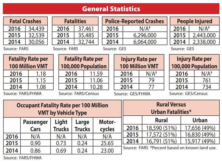
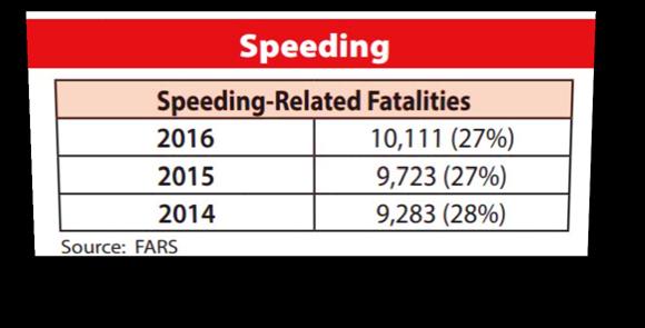
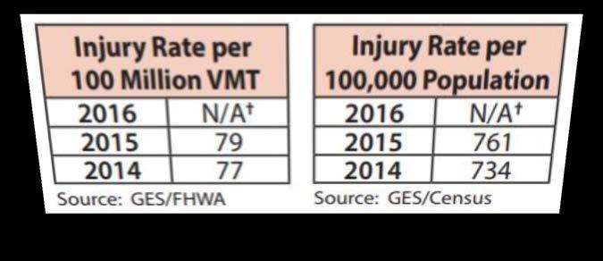
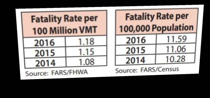
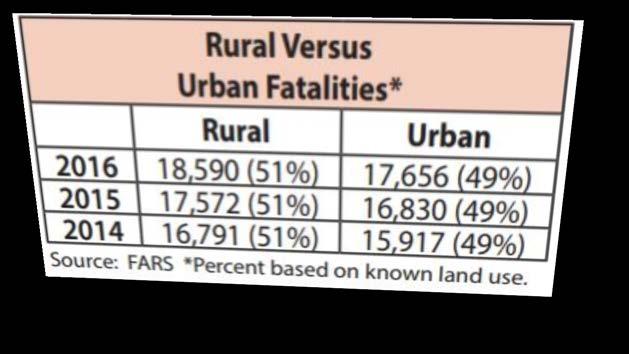
25 The Statistics Large number of fatal crashes classified as roadway departures Many of these occur at horizontal curves In general, crash statistics show increases across-the-board in 2015 and 2016 for the first time in nearly a decade

26 The Statistics


27 Prevailing Methods Accelerometer Method Ball-Bank Indicator Method AASHTO Geometric Design Method Compass Method GPS Method Direct Method V 2 =15(0.01e+f)R


28 Drawbacks of Prevailing Methods Time-consuming Difficult to replicate and verify findings Subjective and Inconsistent Results Equipment installation, calibration, training Personnel Safety during field testing


29 A New Method using Precise, real-world data at your finger tips Curve can be evaluated from the office using TopoDOT, a MicroStation add-on Calculations can be checked, verified and replicated Consistent results


30 How it Works V 2=15(0.01e+f)R Required Inputs using TopoDOT: Posted Speed Friction Factor, f (Table 3-7, AASHTO Green Book 2011) Lane Width
 Establish lane")


31 How it Works (cont d) Establish lane centerline Striping can easily be extracted by intensity Offset to center of lane


32 How it Works (cont d) Drape centerline onto point cloud surface Generate best fit arcs


33 How it Works (cont d) Process data and compile reports


34 The Future of LiDAR Guide rail asset management Pavement Condition Grade Analysis
35 Questions?
Mobile Mapping Solutions for Ohio s Integrated Transportation Network. Brian Foster, CP
 Mobile Mapping Solutions for Ohio s Integrated Transportation Network Brian Foster, CP About Woolpert Established in 1911 Over 600 Professionals 25 Offices $12,000,000 invested in new technology in last
Using Mobile LiDAR To Efficiently Collect Roadway Asset and Condition Data. Pierre-Paul Grondin, B.Sc. Surveying
 Using Mobile LiDAR To Efficiently Collect Roadway Asset and Condition Data Pierre-Paul Grondin, B.Sc. Surveying LIDAR (Light Detection and Ranging) The prevalent method to determine distance to an object
LiDAR AT PennDOT Michael Loose, C.P. BOPD Photogrammetry and Surveys
 LiDAR AT PennDOT Michael Loose, C.P. BOPD Photogrammetry and Surveys 2 I. What is LiDAR? II. Benefits of LiDAR III. PennDOT Case Studies IV. Best Practices/Lessons Learned V. Questions 3 4 LiDAR for Engineering
CASE 1 TWO LANE TO FOUR LANE DIVIDED TRANSITION GEO-610-C NOT TO SCALE GEOMETRIC DESIGN GUIDE FOR MATCH LINE LINE MATCH. 2 (0.6m) shoulder transition
 shoulder transition") CASE 1 2 (0.6m) Joint Line See sheet #5 for description of variables 4 (1.2m) Transition taper is tangent to Edge of Pavement curve at this point. 1:25 Paved shoulder transition 16 (4.m) Median width 16
CASE 1 2 (0.6m) Joint Line See sheet #5 for description of variables 4 (1.2m) Transition taper is tangent to Edge of Pavement curve at this point. 1:25 Paved shoulder transition 16 (4.m) Median width 16
Project Overview Mapping Technology Assessment for Connected Vehicle Highway Network Applications
 Project Overview Mapping Technology Assessment for Connected Vehicle Highway Network Applications ESRI International Users Conference July 2012 Table Of Contents Connected Vehicle Program Goals Mapping
Request for FTE Design Exceptions & Variations Checklist
 District: Project Name: Project Section BMP: EMP: Exemption BMP: EMP: Request for FTE Design Exceptions & Variations Checklist FPID: New Construction RRR Requested Control Element(s): Design Speed* Horizontal
iwitness maps traffic accident scenes over distances of several hundred feet
 iwitness maps traffic accident scenes over distances of several hundred feet Background: In October 2005, the New Hampshire State Patrol (NHSP) teamed with DeChant Consulting Services - DCS Inc to conduct
Pathway Services Inc. Technology Presentation
 Lauren Tran Budapest, Hungary 2015 Largest Vendor of this kind in the U.S. Largest Fleet of Full Service Vehicles in U.S. (26) More Than 5 Million Kilometers Collected Using Our Equipment Nearly 50% of
VTrans Route Logs. Python-driven Map Automation with Straight Line Diagrams. Kerry Alley and Michael Trunzo GIS-T 2014
 VTrans Route Logs Python-driven Map Automation with Straight Line Diagrams Kerry Alley and Michael Trunzo GIS-T 2014 Today s Presentation Straight Line Diagrams Route Log Anatomy VTrans Route Log History
GeoSmart Asia Locate 18
 MOBILE MAPPING GeoSmart Asia Locate 18 ESP Associates, P.A. ESP Associates, P.A. ABOUT ESP Founded in 1986 (28 Years of Experience with DOT s) ESP has 14 offices throughout the US 37 States, Canada, and
Overview September 7, 2017
 Overview September 7, 2017 Purpose The purpose of this presentation is to provide an overview of the changes to the required deliverables and workflow for developing plans and models for Illinois DOT projects
PE Exam Review - Surveying Demonstration Problem Solutions
 PE Exam Review - Surveying Demonstration Problem Solutions I. Demonstration Problem Solutions... 1. Circular Curves Part A.... Circular Curves Part B... 9 3. Vertical Curves Part A... 18 4. Vertical Curves
AN AUTOMATIC HORIZONTAL CURVE RADII MEASUREMENT METHOD FOR ROADWAY SAFETY ANALYSIS USING GPS DATA
 Ai and Tsai 0 AN AUTOMATIC HORIZONTAL CURVE RADII MEASUREMENT METHOD FOR ROADWAY SAFETY ANALYSIS USING GPS DATA Chengbo Ai (corresponding author) Post-Doctoral Fellow School of Civil and Environmental
Engineering Department Overview
 Engineering Department Overview Engineering Department Organization General Manager of Maintenance and Traffic Scott Kapton (Acting) Chief Engineer Paul Kovacs General Manager of Engineering Po Collins
Aerial and Mobile LiDAR Data Fusion
 Creating Value Delivering Solutions Aerial and Mobile LiDAR Data Fusion Dr. Srini Dharmapuri, CP, PMP What You Will Learn About LiDAR Fusion Mobile and Aerial LiDAR Technology Components & Parameters Project
Customizing Survey123 Customization & Submission URL. Kelly Fisher, Project/GIS Manager GeoDecisions
 Customizing Survey123 Customization & Submission URL Kelly Fisher, Project/GIS Manager GeoDecisions Topics/Discussions Desktop Web Device PennDOT STAMPP Review Current STAMPP Application Why Change Current
Creating Value. Delivering Solutions
 Creating Value Delivering Solutions LIDAR...Light Detection and Ranging Technology from the military (1960 s) Rapid, highly accurate DEM coverage of large to medium sized project areas Feature extraction
Minnesota Department of Transportation Metro Barrier Extraction and LiDAR Project
 Minnesota Department of Transportation Metro Barrier Extraction and LiDAR Project Trisha Stefanksi, Primary Author Minnesota Department of Transportation June 2014 Research Project Final Report 2014-22
THIS SLIDE NOT PART OF PRESENTATION.
 THIS SLIDE NOT PART OF PRESENTATION. Abstract: The Ohio Department of Transportation initiated the Roadway Information Management System (RIMS) as a multiphase project to upgrade the architecture, software,
Crash Prediction Modeling for Curved Segments of Rural Two-Lane Two-Way Highways in Utah
 Brigham Young University BYU ScholarsArchive All Theses and Dissertations 2014-12-01 Crash Prediction Modeling for Curved Segments of Rural Two-Lane Two-Way Highways in Utah Casey Scott Knecht Brigham
GRID. Geospatial Roadway Inventory Database. Michael Chamberlain, TxDOT. TPP Planning Conference Houston, TX
 GRID Geospatial Roadway Inventory Database Michael Chamberlain, TxDOT TPP Planning Conference - 2016 Houston, TX Topics 1 2 3 4 5 6 7 8 History (pre GRID) 3-6 GIS Resources 7-8 The Project 9-11 Assets
Particular attention has been paid to the editor s graphics (highlighting of IPs and Elements, tangent points and chainage direction).
.") 12D Super Alignment Parametric Design: The new super alignment utilises not only alignment design by the Fixed and Free method, but introduces a complete new approach to horizontal and vertical road design.
12D Super Alignment Parametric Design: The new super alignment utilises not only alignment design by the Fixed and Free method, but introduces a complete new approach to horizontal and vertical road design.
Utilization of TSMO Practices in Highway Construction Work Zones: A Case Study
 Utilization of TSMO Practices in Highway Construction Work Zones: A Case Study James Webb, P.E., Iowa Department of Transportation Liz Finarty, P.E., Iowa Department of Transportation James Armstrong,
Indoor. Heritage Preservation CAD versus Cloud. inside. Applanix and CSIRO. Grows with LiDAR. Vol. 2 Issue 4 ABOVE & BEYOND. ipad & Tablet Ready!
 inside Indoor Mapping Applanix and CSIRO SMALL BUSINESS Grows with LiDAR Heritage Preservation CAD versus Cloud Vol. 2 Issue 4 ABOVE & BEYOND ipad & Tablet Ready! RE-MODELING THE MIXMASTER From Mobile
A New Way to Control Mobile LiDAR Data
 A New Way to Control Mobile LiDAR Data Survey control has always been a critically important issue when conducting mobile LiDAR surveys. While the accuracies currently being achieved with the most capable
2014 REPORT. Distracted Driving. on I-95 in Northern Virginia
 2014 REPORT Distracted Driving on I-95 in Northern Virginia Distracted Driving on Interstate 95 The National Safety Council estimates that as of May 6, 2014 there have already been 354,913+ crashes this
Geometric Layout for Roadway Design with CAiCE Visual Roads
 December 2-5, 2003 MGM Grand Hotel Las Vegas Geometric Layout for Roadway Design with CAiCE Visual Roads Mathews Mathai CV32-3 This course describes and demonstrates various tools for defining horizontal
Development of a Sensor Platform for Roadway Mapping: Part B Mapping the Road Fog Lines
 Development of a Sensor Platform for Roadway Mapping: Part B Mapping the Road Fog Lines Max Donath, Principal Investigator Intelligent Vehicles Laboratory Department of Mechanical Engineering University
Mississippi DOT's Approach to an Enterprise Wide Linear Referencing System
 Mississippi DOT's Approach to an Enterprise Wide Linear Referencing System Michael Cresap, Mississippi Department of Transportation Bruce Aquila, Intergraph Corporation Concurrent Session 3.4, State LRS
Arizona State Troopers Highway Patrol Division Sergeant John Paul Cartier
 Arizona State Troopers Highway Patrol Division Sergeant John Paul Cartier Average Annual Number of Responders Struck and Killed Nationally 12 Law Enforcement Officers 5 Fire and Rescue Personnel 60 Towing
Horizontal Alignment
 AMRC 2012 MODULE 8 Horizontal Alignment CONTENTS Overview... 8-1 Objectives... 8-1 Procedures... 8-1 8.1 Design Considerations and Circular Curves... 8-3 8.2 Superelevation and Transitional Spiral... 8-5
Critical Assessment of Automatic Traffic Sign Detection Using 3D LiDAR Point Cloud Data
 1 2 3 4 5 6 7 8 9 10 11 12 13 14 15 16 17 18 19 Critical Assessment of Automatic Traffic Sign Detection Using 3D LiDAR Point Cloud Data Chengbo Ai PhD Student School of Civil and Environmental Engineering
How Iowa DOT is using its Linear Referencing System. Eric Abrams Spatial Coordinator Iowa DOT Gis.iowadot.gov
 How Iowa DOT is using its Linear Referencing System Eric Abrams Spatial Coordinator Iowa DOT Gis.iowadot.gov Eric.abrams@dot.iowa.gov Linear Referencing System A set of procedures and methods for specifying
Copyright 2011 by Daniel Jonathan Findley. All Rights Reserved
 ABSTRACT FINDLEY, DANIEL JONATHAN. A Comprehensive Two-Lane, Rural Road Horizontal Curve Study Procedure. (Under the direction of Joseph E. Hummer and William Rasdorf.) Horizontal curves are relatively
Precision Roadway Feature Mapping Jay A. Farrell, University of California-Riverside James A. Arnold, Department of Transportation
 Precision Roadway Feature Mapping Jay A. Farrell, University of California-Riverside James A. Arnold, Department of Transportation February 26, 2013 ESRA Fed. GIS Outline: Big picture: Positioning and
Interactive Highway Safety Design Model (IHSDM) Workshop Nevada DOT Las Vegas, NV February 13, 2014
 Workshop Nevada DOT Las Vegas, NV February 13, 2014") Interactive Highway Safety Design Model (IHSDM) Workshop Nevada DOT Las Vegas, NV February 13, 2014 Overview Hands-on Exercises: IHSDM Crash Prediction Module (CPM) The Crash Prediction Module estimates
Interactive Highway Safety Design Model (IHSDM) Workshop Nevada DOT Las Vegas, NV February 13, 2014 Overview Hands-on Exercises: IHSDM Crash Prediction Module (CPM) The Crash Prediction Module estimates
KEEPING DATA ACCURATE WITH THE DUSA APPLICATION
 KEEPING DATA ACCURATE WITH THE DUSA APPLICATION Jenn Sylvester, Mapping Branch Team Lead Adam Breznicky, Mapping Branch Web Master Transportation Planning & Programming Division (TPP) ESRI International
Automated Road Segment Creation Process
 David A. Noyce, PhD, PE Director and Chair Traffic Operations and Safety Laboratory Civil and Environmental Engineering Department Kelvin R. Santiago, MS, PE Assistant Researcher Traffic Operations and
A New Direction in GIS Data Collection or Why Are You Still in the Field?
 GeoAutomation The Mobile Mapping System Survey-Enabled Imagery A New Direction in GIS Data Collection or Why Are You Still in the Field? Presentation to: URISA BC GIS Technology Showcase January 19, 2011
Lesson 4: Crash Prediction Module (CPM)
") Go back to: Table of Contents Go to the next lesson Overview : Crash Prediction Module (CPM) The Crash Prediction Module estimates the frequency and severity of crashes that would be expected on a highway
Go back to: Table of Contents Go to the next lesson Overview : Crash Prediction Module (CPM) The Crash Prediction Module estimates the frequency and severity of crashes that would be expected on a highway
Figure 1: Mobile mapping project location in New York City.
 Using Mobile LiDAR to Deliver Survey Accurate Data This presentation will take the attendees though the process of controlling and delivering survey grade LiDAR data for use in CADD, Modeling, and GIS
DAVID WOLFE TMC Operations & Incident Management Specialist
 DAVID WOLFE TMC Operations & Incident Management Specialist Professional Background Education Temple University, B.A. - Communications Licenses/Certificates FEMA NIMS: ICS-100 ICS-200 ICS-300 ICS-400 IS-700
Cedar Rapids ITS Deployment Project
 Cedar Rapids ITS Deployment Project Concept of Operations July 29, 2011 Table of Contents Section 1 Introduction Purpose Goal of ITS Deployments Section 2 Needs Assessment General Background Stakeholders
Montana Department of Transportation (MDT) Location/Linear Referencing System (LLRS) Design Process
 Location/Linear Referencing System (LLRS) Design Process") Montana Department of Transportation (MDT) Location/Linear Referencing System (LLRS) Design Process Marlin Sander, MDT and Bill Schuman, GeoDecisions Session Outline Current MDT s transportation inventory
Montana Department of Transportation (MDT) Location/Linear Referencing System (LLRS) Design Process Marlin Sander, MDT and Bill Schuman, GeoDecisions Session Outline Current MDT s transportation inventory
Philip J. Meis, M.S., P.E., M.ASCE Chair
 Establishing ASCE Standard Consensus Activity for Utility As-Built Records Philip J. Meis, M.S., P.E., M.ASCE Chair Utility As-Built Standard Overview Background and Need Scope Committee Members Schedule
Managing a Multilevel Linear Referencing System. Phil Hardy Transportation Industry Consultant
 Managing a Multilevel Linear Referencing System Phil Hardy Transportation Industry Consultant Agenda Design goals of Temporal, Multilevel LRS 4 big hairy problems Maintaining a Temporal, Multilevel LRS
Horizontal and Vertical Curve Design
 Horizontal and Vertical Curve Design CE 576 Highway Design and Traffic Safety Dr. Ahmed Abdel-Rahim Horizontal Alignment Horizontal curve is critical. Vehicle cornering capability is thus a key concern
WYOMING DEPARTMENT OF TRANSPORTATION
 PAGE 1 OF 5 WYOMING DEPARTMENT OF TRANSPORTATION ROAD DESIGN MEMORANDUM #02 DATE OF ISSUE: December 01, 2004 Approved by: Paul P. Bercich, P.E. Highway Development Engineer Issued by: Engineering Services,
Georeferencing West Virginia DOT s Roadside Assets: An Asset Inventory Case Study. Geoff Dew April 13,
 : An Asset Inventory Case Study Geoff Dew April 13, 2010 General Project Scope 17,817 miles collected across all systems. System Type Delivered Miles 1 Interstates 1100.820 2 US Routes 2184.538 3 WV Routes
Web-Distributed, Geo-temporal, Integrated Information Systems The Apache County Experience
 Web-Distributed, Geo-temporal, Integrated Information Systems The Apache County Experience Josephine R. Wyman Chief Executive Paphun Wangmutitakul Principal Programmer Max M. Wyman, Ph.D. Principal Scientist
DISTRICT 6-0 REGIONAL OPERATIONS PLAN PENNSYLVANIA DEPARTMENT OF TRANSPORTATION ENGINEERING DISTRICT 6-0
 MINUTES OF MEETING (FINAL) PROJECT: PURPOSE OF MEETING: LOCATION: PENNDOT Agreement E00229 Open-end Agreement for ITS, Traffic and Highway Safety Engineering Services Work Order 016 - District 6-0 Regional
JCE 4600 Fundamentals of Traffic Engineering. Horizontal and Vertical Curves
 JCE 4600 Fundamentals of Traffic Engineering Horizontal and Vertical Curves Agenda Horizontal Curves Vertical Curves Passing Sight Distance 1 Roadway Design Motivations Vehicle performance Acceleration
Quantifying Grade Crossing Condition as an Input to Modeling Safety
 Quantifying Grade Crossing Condition as an Input to Modeling Safety Teng (Alex) Wang & Reginald Souleyrette University of Kentucky, Lexington, KY Ahmed Aboubakr & Edward Randerson University of Illinois
Rethinking Road Planning and Design Workflows:
 Rethinking Road Planning and Design Workflows: Unlocking the Potential of LiDAR Craig Speirs Softree Technical Systems Forest road construction is one of the most expensive components of timber harvesting.
Photogrammetry: A Modern Tool for Crash Scene Mapping
 Photogrammetry: A Modern Tool for Crash Scene Mapping Background A police accident investigator (AI) has many tasks when arriving at a crash scene. The officer s highest priority is public safety; the
Work Type Definition
 Work Type Definition Pages 1-3 detail the work type definition. In order to become pre-qualified for this work type, please see the Work Type Submittal Requirements on pages 4-6. I. Description Refer to
Jeffrey A. Schepers P.S. EIT Geospatial Services Holland Engineering Inc. 220 Hoover Blvd, Suite 2, Holland, MI Desk
 Jeffrey A. Schepers P.S. EIT Geospatial Services Holland Engineering Inc. 220 Hoover Blvd, Suite 2, Holland, MI 49423 616-594-5127 Desk 616-322-1724 Cell 616-392-5938 Office Mobile LiDAR - Laser Scanning
Video Based Asset Data Collection at NJDOT
 Video Based Asset Data Collection at NJDOT DEPARTMENT TRANPORTATION JEREY DEPARTMENT TRANPORTATION JEREY Presenters Richard A. Robyak, PE Michael Baker Jr., Inc. GIT Practice Leader Transportation Greg
AASHTOWare BrR - SIMPLE SPAN PRESTRESSED I BEAM EXAMPLE - BR 76015
 AASHTOWare BrR - SIMPLE SPAN PRESTRESSED I BEAM EXAMPLE - BR 76015 M N D O T B R I D G E S T A T E A I D Page 1 PS1 - Simple Span Prestressed I Beam Example (BrR 6.7.1) 1. From the Bridge Explorer create
Development and Maintenance of a Critical Application Geodatabase For DOT Use.
 Development and Maintenance of a Critical Application Geodatabase For DOT. Executive Summary This paper presents a description of the development and maintenance of a state-level database used by the Louisiana
Title: Improving Your InRoads DTM. Mats Dahlberg Consultant Civil
 Title: Improving Your InRoads DTM Mats Dahlberg Consultant Civil Improving Your InRoads Digital Terrain Model (DTM) Digital Terrain Model A digital representation of a surface topography or terrain composed
Civil 3D Introduction
 Civil 3D Introduction Points Overview Points are data collected by surveyors which represent existing site conditions (elevations, boundaries, utilities, etc.). Each point is numbered (or named) and has
Road Intersections Near Level Crossings: Intersection Awareness in Illinois. Brian Vercruysse Illinois Commerce Commission
 Road Intersections Near Level Crossings: Intersection Awareness in Illinois Brian Vercruysse Illinois Commerce Commission Illinois Freight & Passenger Rail Systems Metra Commuter Illinois Rail Crossing
Commercial suas The Right Tool for the Right Job
 Commercial suas The Right Tool for the Right Job Presentation Objectives Overview of current data collection technologies UAS Systems Overview Surveyor 2.0 Project Case Study Mobile LiDAR & suas How Do
Proposed Resolution Joint Technical Committee on Electronic Engineering Data Title: Endorsement of TransXML
 Proposed Resolution Joint Technical Committee on Electronic Engineering Data Title: Endorsement of TransXML WHEREAS, Advancements in technology are providing increasing opportunities and needs for the
GIS-T 2016 PennDOT s Path to Survey123 for Field Collection
 GIS-T 2016 PennDOT s Path to Survey123 for Field Collection Jeff Fennimore, Spatial Infrastructure Manager Pennsylvania DOT Nate Reck, Gov t Solutions Director GeoDecisions Topics/Discussions Asset Condition
A Business-driven Approach to Linear Network Management for Roads
 A Business-driven Approach to Linear Network Management for Roads A Bentley White Paper Russell Page Director of Business Development Published: April 2017 www.bentley.com Introduction A linear referencing
Innovation. lidarnews.com. volume 3 issue 5. Points clouds and terrain models support rail project. Structured light scanning for human head modeling
 volume 3 issue 5 LIDAR lidarnews.com SCALABILITY Points clouds and terrain models support rail project EXPRESSION Structured light scanning for human head modeling FLUCTUATION Scanning moving objects using
2009 IHEEP CONFERENCE The Future of CORS Networks and AMG
 2009 IHEEP CONFERENCE The Future of CORS Networks and AMG Background Dominick Izzo, PE Lancaster Development, Inc. Heavy Highway Contractor in Upstate NY Member of NYSAGC/NYSDOT Emerging Technology Committee
Managing DC Work Zones via a Citywide Transportation Management Plan. ITE Mid-Colonial District Annual Meeting May 20, 2014
 Managing DC Work Zones via a Citywide Transportation Management Plan ITE Mid-Colonial District Annual Meeting May 20, 2014 Presentation Outline The Team The Challenge The Approach Project Diagram Work
2/19/2018. Who are we? Who am I? What is Scanning? How does scanning work? How does scanning work? Scanning for Today s Surveyors
 2/19/2018 Who are we? Scanning for Today s Surveyors Survey, GIS, and Construction dealer Founded in 1988 Employee Owned Headquartered in Bismarck, ND States covered: ND, SD, MN, MT, WY, CO, UT, ID, WA,
CREATING CURVE DATA ON LOCAL ROADS TO SUPPORT SAFETY ANALYSIS
 CREATING CURVE DATA ON LOCAL ROADS TO SUPPORT SAFETY ANALYSIS Session 1.4.3 April 11, 2017 2:30pm Michael Trunzo, VTrans, Montpelier, VT Joe Breyer, Works Consulting, Gilbert AZ Vermont Agency of Transportation
South Central ROP Projects
 Pennsylvania Department of Transportation ROP Overview and Summary South Central ROP Projects November 2007 77 INCIDENT MANAGEMENT (IM) Draft Version 1 July 2007-40 - IM 1: SOUTH CENTRAL PA ITS DEPLOYMENT
Road Surface Texture Evaluation with 3-D Laser Data
 Road Surface Texture Evaluation with -D Laser Data Shuvo Islam 1, Mustaque Hossain, and Humaira Zahir ( 1 Kansas State University, Manhattan, KS, USA, sislam@ksu.edu) ( Kansas State University, Manhattan,
LSGI 521: Principles of GIS. Lecture 5: Spatial Data Management in GIS. Dr. Bo Wu
 Lecture 5: Spatial Data Management in GIS Dr. Bo Wu lsbowu@polyu.edu.hk Department of Land Surveying & Geo-Informatics The Hong Kong Polytechnic University Contents 1. Learning outcomes 2. From files to
Multilevel Linear Referencing Systems & Temporal Data Management Phil Hardy & Bruce Aquila
 Multilevel Linear Referencing Systems & Temporal Data Management Phil Hardy & Bruce Aquila Security, Government & Infrastructure Agenda Design goals of Temporal, Multilevel LRS 4 big hairy problems Maintaining
Data Access User Needs Study A User Needs Assessment for the Colorado DOT (CDOT)
") Data Access User Needs Study A User Needs Assessment for the Colorado DOT (CDOT) Lou Henefeld, GIS Support Unit Manager, Colorado DOT Louis.henefeld@dot.state.co.us Allen Ibaugh, CEO, Data Transfer Solutions
Data Access User Needs Study A User Needs Assessment for the Colorado DOT (CDOT) Lou Henefeld, GIS Support Unit Manager, Colorado DOT Louis.henefeld@dot.state.co.us Allen Ibaugh, CEO, Data Transfer Solutions
Bentleyuser.dk Årsmøde 2012 Nordic Civil 2012
 Bentleyuser.dk Årsmøde 2012 Nordic Civil 2012 5.-7. November 2012, Munkebjerg Hotel, Vejle Workshop X13 Advanced Geometrical Layout for Compound and Reversed Curves Team Leader: Richard Bradshaw Bentley
A parabolic curve that is applied to make a smooth and safe transition between two grades on a roadway or a highway.
 A parabolic curve that is applied to make a smooth and safe transition between two grades on a roadway or a highway. VPC: Vertical Point of Curvature VPI: Vertical Point of Intersection VPT: Vertical Point
GIS Based Tools for County Road Management Crash Data Analysis Application. January 12, 2012
 GIS Based Tools for County Road Management Crash Data Analysis Application January 12, 2012 Good News: Crash Rates for All Types of Crashes in Unincorporated Maricopa County Are Declining 2,000 Crashes
Validation of Aerial LiDAR Products For Transportation Applications
 Creating Value Delivering Solutions Validation of Aerial LiDAR Products For Transportation Applications Dr. Srini Dharmapuri, CP, PMP Michael Baker Jr., Inc. Lauren Little, PE Alaska DOT Public Facility
Getting Results from Regional Traffic Incident Management Teams
 Getting Results from Regional Traffic Incident Management Teams Polk County, Florida TIM Team 2008 By: Don Olson and Arland T. (Ted) Smith Florida Department of Transportation District One If this incident
Building an Enterprise GeoDatabase to Support a Service Oriented Architecture
 Dan Widner VDOT Dan.Widner@vdot.virginia.gov Paul Bucher Keane, Inc Paul.Bucher@vdot.virginia.gov Historical Perspective and Vision Technical Approach Historical Perspective and Vision A Bit of History
SHRP 2 Safety Research Symposium July 27, Site-Based Video System Design and Development: Research Plans and Issues
 SHRP 2 Safety Research Symposium July 27, 2007 Site-Based Video System Design and Development: Research Plans and Issues S09 Objectives Support SHRP2 program research questions: Establish crash surrogates
STUDY REPORT #1 ADDENDUM
 STUDY REPORT #1 ADDENDUM 1.0 PURPOSE OF ADDENDUM This document is an addendum to Study Report #1: Sub-System Planning Alternatives. The purpose of this addendum is to bridge the gap between the initial
Cuyahoga County Addressing Notification System Cuyahoga County Department of Information Technology
 Page(s) 1 of 10 Administrative Standard Operating Procedure Cuyahoga County Addressing Notification System Cuyahoga County Department of Information Technology Document Revision History Date of Revision
Fox River Grove, 20 Years Later. Brian Vercruysse, PE November 3, 2015 Arlington, TX
 Fox River Grove, 20 Years Later Brian Vercruysse, PE November 3, 2015 Arlington, TX Interconnect Awareness October 25, 1995 Fox River Grove, Illinois Everything that could go wrong went wrong Was the start
ENHANCED PARKWAY STUDY: PHASE 3 REFINED MLT INTERSECTION ANALYSIS
 ENHANCED PARKWAY STUDY: PHASE 3 REFINED MLT INTERSECTION ANALYSIS Final Report Prepared for Maricopa County Department of Transportation Prepared by TABLE OF CONTENTS Page EXECUTIVE SUMMARY ES-1 STUDY
IP-S2 HD. High Definition 3D Mobile Mapping System
 IP-S2 HD High Definition 3D Mobile Mapping System Integrated, turnkey solution Georeferenced, Time-Stamped, Point Clouds and Imagery High Density, Long Range LiDAR sensor for ultimate in visual detail
Airborne LiDAR Surveys and Data Delivery in the Pipeline Industry
 Airborne LiDAR Surveys and Data Delivery in the Pipeline Industry Carlos Femmer Faron Olivier October 25, 2011 October 25, 2011 GITA GIS for Oil and Gas Pipeline 2011 Organization Fugro is a decentralized
Design Elements Horizontal Milos N. Mladenovic Assistant Professor Department of Built Environment
 Design Elements Horizontal Milos N. Mladenovic Assistant Professor Department of Built Environment 01.03.2017 Outline Highway alignment Vehicle cornering forces Minimum radius Circular curve elements Transition
Essentials for professional use
 Road Surveys using smartphones Essentials for professional use June 2016 - App version 2.1.8- This guide gives a short introduction and briefly describes how to: 1. Collect road roughness data + auto photos
Trimble VISION Positions from Pictures
 Trimble VISION Positions from Pictures This session will cover What Is Trimble VISION? Trimble VISION Portfolio What Do you Need? How Does It Work & How Accurate Is It? Applications Resources Trimble VISION
CHAPTER 11. Learn to use GEOPAK Automated Superelevation dialog box and Autoshape Builder to apply superelevation to a roadway.
 CHAPTER 11 Superelevation 11.1 Introduction Objectives Project Manager Learn to use GEOPAK Automated Superelevation dialog box and Autoshape Builder to apply superelevation to a roadway. Calculate Superelevation
2011 Bentley Systems, Incorporated. Bentley Descartes V8i Advancing Information Modeling For Intelligent Infrastructure
 Bentley Descartes V8i Advancing Information Modeling For Intelligent Infrastructure Agenda Why would you need Bentley Descartes? What is Bentley Descartes? Advanced Point Cloud Workflows Advanced Terrain
AED Design Requirements: Superelevation Road Design
 US Army Corps of Engineers Afghanistan Engineer District AED Design Requirements: Various Locations, Afghanistan MARCH 2009 TABLE OF CONTENTS AED DESIGN REQUIREMENTS FOR SUPERELEVATION ROAD DESIGN VARIOUS
A Whole New World of Mapping and Sensing: Uses from Asset to Management to In Vehicle Sensing for Collision Avoidance
 A Whole New World of Mapping and Sensing: Uses from Asset to Management to In Vehicle Sensing for Collision Avoidance Charles Toth, Dorota A Grejner-Brzezinska, Carla Bailo and Joanna Pinkerton Satellite
1.4.3 OPERATING SPEED CONSISTENCY
 Geometric Design Guide for Canadian oads 1.4.3 OPEATING SPEED CONSISTENCY The safety of a road is closely linked to variations in the speed of vehicles travelling on it. These variations are of two kinds:
Estimation of Suitable Grade Value for Stopping Sight Distance Computation on Vertical Curves
 Estimation of Suitable Grade Value for Stopping Sight Distance Computation on Vertical Curves Ahmed H. Farhan Assist. ecturer / Civil Eng. Dept. / Anbar University Abstract The purpose of highway geometric
inspiring innovative Infratech Jyväskylä infra3d unique simplify 12 May 2017 Manuel Dätwyler Product Management infra3d
 inspiring Infratech Jyväskylä infra3d 12 May 2017 Manuel Dätwyler Product Management infra3d simplify unique innovative What s the issue? «cost-intensive infrastructure management» 2 What are yours subjects