NJTPA Enterprise GIS Implementation
|
|
|
- Kory Neal
- 5 years ago
- Views:
Transcription


1 GIS-T 24 th Annual Symposium Presented by Zenobia L. Fields March 28th, 2011 DATA COLLECT COORDINATE DISTRIBUTE PRODUCE MAINTAIN ANALYZE
2 Overarching Project Goal: Develop a Data Management Tool Consolidate information from multiple sources into an enterprise-class Relational Database Management System (RDBMS) Develop tools and functions that will improve the NJTPA s mission-critical business functions and associated work flows Build the foundation for next-generation business and web-based applications Project Approach 9 General Tasks (7 Technical Tasks) 12 Months Needs Assessment Data Inventory Discovery Phase Design Phase Implementation Phase System Requirements Design Database Application Design System Development & Deployment System Acceptance

3 Discovery Phase : Assess Needs Technology Resources Policies Data Systems Programs Limitations


4 Discovery Phase : Products 1. Requirements Document: Business Process, Functionality, Hardware, Software 2. System-Wide Concept Design:
 Saf ety Socio Economic Forecasting Strategy Evaluation/ Strategy")
5 Database Design NJTPA Concept Database Composed of 15 Subject Areas and associated GIS layers and Tables Air Quality Conformity Capital Programmin g Census NJ Congestion Management System Freight Assessment Land Use Regional Household Travel Surveys Regional Planning Studies North Jersey Regional Travel Model Enhanced (NJRTME) Saf ety Socio Economic Forecasting Strategy Evaluation/ Strategy Ref inement Transit NJDOT Management Systems Other ArcCatlog View of Actual Geodatabase
 Transit Associated")

 =")
6 Database Design (Transit Logical Design example) Transit Associated tables and GIS layers Modeling data relationships during processing normalization of data = Parent = Child l = GIS layer t = table (FK) = Foreign Key


7 Database Design : Physical Design 2008 SQL Server Back-End Data Management with ArcSDE Data Loading / Cleaning / Archiving Four-Tier System GDB_DEV GDB_STAGE GDB_PROD GDB_HIST
8 Database Design : Products 1. Four-Tiered Geodatabase System 2. Quality Assurance Program 3. Operating Standards 4. Framework Categories (GIS layer naming conventions) 5. Naming Conventions 6. Inventory Maintenance Standards 7. Exchange Standards
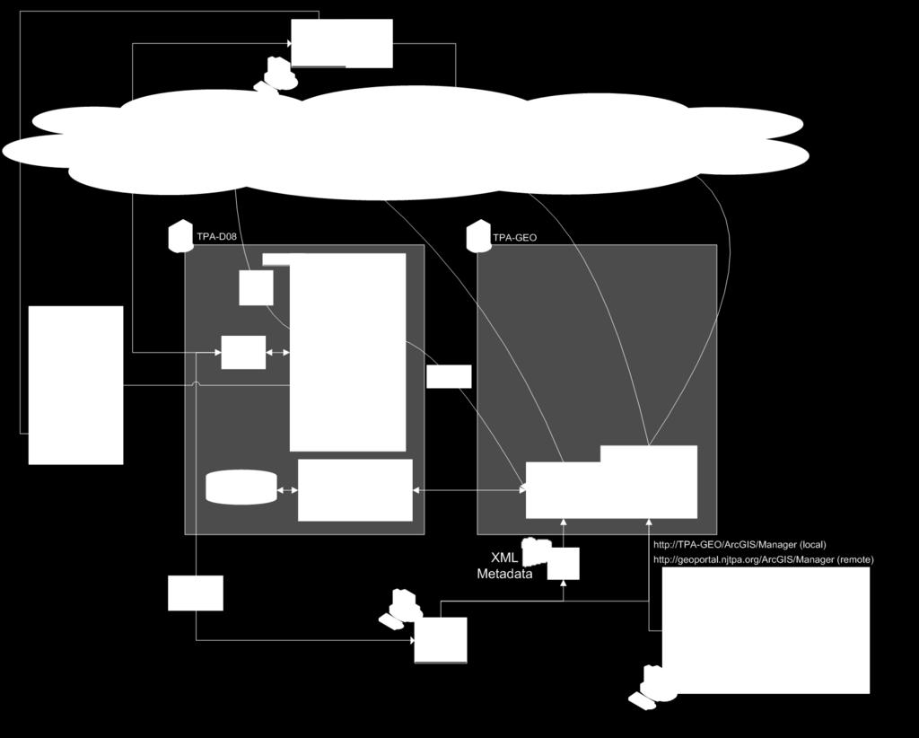
9 1. Capital Program NJTPA Enterprise GIS Implementation Application Design 2. ArcGIS Server 3. NJTPA Geoportal a. Dynamic Inventory b. Metadata Catalog c. Map Services d. Web Downloads 4. Geographic Clipping Tool

10 Application Design

11 Application Design: Capital Program Data Management

12 Application Design: Capital Program Data Management

13 Application Design: NJTPA Geoportal - Data Sharing E-GIS Direct Authorized Access via ArcCatalog Map Services Geodatabase Services Metadata Catalog
14 Application Design: NJTPA Geoportal - Demo
15 System Implementation : Maintenance Plan & Schedule 1. Administrators Manual 2. User Manual 3. Exchange Schedule: First Quarter: July 1st to July 15th Second Quarter: October 1st to October 15th Third Quarter: January 1st to January 15th Fourth Quarter: April 1st to April 15th 4. Foundation for Replication
16 EGIS Next Steps Year 2 Year 3 1 Consolidate year 1 EGIS achievements 2 Formally adopt direct geodatabase to geodatabase data transfer methods 3 Deploy rich, ArcGIS Server web applications to support project specific needs 4 Integrate the new NJTPA Online Transportation Information System (NOTIS) capital program application with the EGIS platform 6 Ensure that Air Quality conformity outputs are consistent with Geodatabase logical data model 1 Integrate wireless applications with the EGIS platform 2 Become fully integrated into a cloud computing environment 3 Integrate a new agency-wide document sharing system into the EGIS platform
17 More Information Geoportal Site: Map Services: Applications: Contact Info: Zenobia L. Fields Principal GIS and Data Development Planner North Jersey Transportation Planning Authority Tel: Fax: Web:
NJTPA Enterprise GIS (EGIS) User Manual
 User Manual") NJTPA Enterprise GIS (EGIS) User Manual COLLECT COORDINATE DATA DISTRIBUTE PRODUCE MAINTAIN ANALYZE NJTPA Enterprise GIS (EGIS) User Manual Quick Reference EGIS User Manuals Support Documents Appendices
NJTPA Enterprise GIS (EGIS) User Manual COLLECT COORDINATE DATA DISTRIBUTE PRODUCE MAINTAIN ANALYZE NJTPA Enterprise GIS (EGIS) User Manual Quick Reference EGIS User Manuals Support Documents Appendices
Webinar on Shared Transportation Services - Leveraging GTFS with Regional Partners. June 20, 2018
 Webinar on Shared Transportation Services - Leveraging GTFS with Regional Partners Webinar & Audio Information The call-in phone number is: 1-xxx-xxx-xxxx & enter xxxxxxx# at the prompt. Participants will
Introduction to Geodatabase and Spatial Management in ArcGIS. Craig Gillgrass Esri
 Introduction to Geodatabase and Spatial Management in ArcGIS Craig Gillgrass Esri Session Path The Geodatabase - What is it? - Why use it? - What types are there? - What can I do with it? Query Layers
Esri s ArcGIS Enterprise. Today s Topics. ArcGIS Enterprise. IT4GIS Keith T. Weber, GISP GIS Director ISU GIS Training and Research Center
 Esri s ArcGIS Enterprise IT4GIS Keith T. Weber, GISP GIS Director ISU GIS Training and Research Center Today s Topics Part 1: ArcGIS Enterprise architecture Part 2: Storing and serving data for the enterprise
Subject: Migration Information for ArcIMS, ArcSDE, and ArcGIS Server Users
 December 12, 2006 Subject: Migration Information for ArcIMS, ArcSDE, and ArcGIS Server Users Summary This document provides information about how we are migrating your licenses and maintenance for ESRI
Esri s Spatial Database Engine. Today s Topics. ArcSDE. A spatial database engine that works on
 Esri s Spatial Database Engine IT4GIS Keith T. Weber, GISP GIS Director ISU GIS Training and Research Center Today s Topics Part 1: What is ArcSDE? Why use ArcSDE? ArcSDE Data Structure How is data stored
ArcGIS 9.2 Works as a Complete System
 ArcGIS 9.2 Works as a Complete System A New Way to Manage and Disseminate Geographic Knowledge Author/Serve/Use Maps Data Models Globes Metadata Use Desktop Explorer Web Map Viewer Mobile Open APIs Enterprise
Editing Versioned Geodatabases : An Introduction
 Esri International User Conference San Diego, California Technical Workshops July 24, 2012 Editing Versioned Geodatabases : An Introduction Cheryl Cleghorn Shawn Thorne Assumptions: Basic knowledge of
2045 DEMOGRAPHIC FORECAST SURFACE TRANSPORTATION TECHNICAL COMMITTEE APRIL 28, 2017
 2045 DEMOGRAPHIC FORECAST SURFACE TRANSPORTATION TECHNICAL COMMITTEE APRIL 28, 2017 BACKGROUND The demographic forecasts provide a common base for regional planning and resource allocations. The forecasts
Unified Planning Work Program. Budget Book
 FY2018UPWP Unified Planning Work Program Book FY 2018 Unified Planning Work Program Overview The accompanying report provides necessary details regarding the MPO's anticipated expenses for the FY 2018
Travel Demand Modeling and Project Coding Procedures
 Travel Demand Modeling and Project Coding Procedures Revised July 2008 As described in the Final Transportation Conformity Rule (section 93.122), travel demand models used to generate emission estimates
Introduction to ArcCatalog
 Introduction to ArcCatalog Introduction To Arc Catalog ArcCatalog is a data- centric GUI tool used for managing spatial data With ArcCatalog you can. Inspect properties and attributes of data Preview and
Regional TSM&O Vision and ITS Architecture Update
 Regional TSM&O Vision and ITS Architecture Update Progress Update Transportation Coordinating Committee April 5, 2019 Task List (2018 2020) 1. Develop a Regional TSM&O Vision 2. Document Current TSM&O
The Oracle Enterprise Geodatabase (EGDB) Charlie Crocker Farallon Geographics, Inc.
 Charlie Crocker Farallon Geographics, Inc.") The Oracle Enterprise Geodatabase (EGDB) Charlie Crocker Farallon Geographics, Inc. www.fargeo.com Norcal URISA Chapter Meeting 2/9/2005 Todays Goals Enterprise geodatabase defined Roles Oracle can play
The Oracle Enterprise Geodatabase (EGDB) Charlie Crocker Farallon Geographics, Inc. www.fargeo.com Norcal URISA Chapter Meeting 2/9/2005 Todays Goals Enterprise geodatabase defined Roles Oracle can play
hereby recognizes that Timotej Verbovsek has successfully completed the web course 3D Analysis of Surfaces and Features Using ArcGIS 10
 3D Analysis of Surfaces and Features Using ArcGIS 10 Completed on September 5, 2012 3D Visualization Techniques Using ArcGIS 10 Completed on November 19, 2011 Basics of Map Projections (for ArcGIS 10)
Collector for ArcGIS Preparing for and Working in a disconnected environment
 Collector for ArcGIS Preparing for and Working in a disconnected environment Peter Nasuti, Dan Moore, Nicholas Davis Topics Covered With demonstrations throughout each step 1) What is Collector? What can
ICIT. Brian Hiller ESRI Account Manger. What s new in ArcGIS 10
 ICIT Brian Hiller ESRI Account Manger What s new in ArcGIS 10 ArcGIS 10 Fast Easy Powerful Everywhere late June 2010 ArcGIS System for Geographic Information Desktop Server Mobile Online A System A Complete
Oracle Spatial A Unifying Framework at the Utah Department Of Transportation
 Oracle Spatial A Unifying Framework at the Utah Department Of Transportation Dan Paske Utah Department of Transportation Oracle DBA Jeff Saunders Farallon Geographics, Inc. Senior Geodatabase Developer
Deploying and Using ArcGIS Explorer for Petroleum Users Bern Szukalski ESRI Redlands
 Deploying and Using ArcGIS Explorer for Petroleum Users Bern Szukalski ESRI Redlands 1 ArcGIS: A Comprehensive GIS System Mobile, Web, Server, Desktop 2 Mapping, Cartography, Visualization, Editing, Data
Design a Geodatabase. Rasu Muthurakku, Enterprise Solutions Architect / Consultant
 Rasu Muthurakku, Enterprise Solutions Architect / Consultant Agenda Overview Key Factors Design - Recommendations Key Considerations, Best Practices and Recommendations / Lessons Learned! Overview What
Introduction to ArcSDE 8. John Calkins
 Introduction to ArcSDE 8 John Calkins Why are you here? Introduction to ArcSDE? What is a GeoDatabase? Existing SDE user? Existing ArcInfo user? Technical details on implementation? Just confused... ArcSDE
Lesson 12: ArcGIS Server Capabilities
 GEOG 482 / 582 : GIS Data Management Lesson 12: ArcGIS Server Capabilities Overview Learning Objective Questions: 1. What are the ArcGIS Server Services? 2. How is ArcGIS Server packaged? 3. What are three
Figure 1: Summary Status of Actions Recommended in June 2016 Committee Report. Status of Actions Recommended # of Actions Recommended
 Chapter 3 Section 3.05 Metrolinx Regional Transportation Planning Standing Committee on Public Accounts Follow-Up on Section 4.08, 2014 Annual Report In November 2015, the Standing Committee on Public
Market Report. Scale-out 2.0: Simple, Scalable, Services- Oriented Storage. Scale-out Storage Meets the Enterprise. June 2010.
 Market Report Scale-out 2.0: Simple, Scalable, Services- Oriented Storage Scale-out Storage Meets the Enterprise By Terri McClure June 2010 Market Report: Scale-out 2.0: Simple, Scalable, Services-Oriented
Enterprise Geographic Information Servers. Dr David Maguire Director of Products Kevin Daugherty ESRI
 Enterprise Geographic Information Servers Dr David Maguire Director of Products Kevin Daugherty ESRI Outline Introduction Enterprise GIS vs. Spatially-enabled IS Architectures for building Enterprise GIS
Overview of System Center 2012 R2 Configuration Manager
 Overview of System Center 2012 R2 Configuration Manager Lesson 1: Introduction to System Center 2012 R2 Configuration Manager Overview of the System Center 2012 Environment Overview of System Center 2012
Leveraging SAP HANA and ArcGIS. Melissa Jarman Eugene Yang
 Melissa Jarman Eugene Yang Outline SAP HANA database ArcGIS Support for HANA Database access Sharing via Services Geodatabase support Demo SAP HANA In-memory database Support for both row and column store
S s y t s em e s s Ar A ch c i h tec e t c ur u e e De D s e i s gn g, n C o C n o f n igu g r u at a ion o, n a n a d n D p e l p oy o m y en e t
 Systems Architecture Design, Configuration, and Deployment Tom Pattison and Michael Young Version 3.1 Agenda What is System Architecture? Design - System Architecture Business Data Application Technology
Software and Migration Services FAQ for more information (available from Electronic Data Solutions ). Some implementation will be required, including
. Some implementation will be required, including") Sales and Marketing What is the target audience for FieldSeeker GIS for Mosquito Control? It is hoped that FieldSeeker GIS for Mosquito Control will serve the needs of small, medium, and large enterprise
Sales and Marketing What is the target audience for FieldSeeker GIS for Mosquito Control? It is hoped that FieldSeeker GIS for Mosquito Control will serve the needs of small, medium, and large enterprise
High Visibility Enforcement TN Grants Tip Sheets
 High Visibility Enforcement TN Grants Tip Sheets Tennessee Highway Safety Office Updated October 26, 2017 High Visibility Enforcement Grant Tip Sheets 1 Table of Contents Claim without Expenses (Zero Quarter
Using the Geodatabase
 Using the Geodatabase February 13, 2002 Presented by: John Stroud, ESRI GeoDatabase Geodatabase comes in two flavors Personal mdb format ArcSDE rdbms format ArcGIS is a suite of three products ArcView,
AGIC 2012 Workshop Leveraging Free RDBMS in ArcGIS
 AGIC 2012 Workshop Leveraging Free RDBMS in ArcGIS Prescott, AZ October 2012 Instructors: Bo Guo, PE, PhD Terry Li Workshop Outline Part I Introduction Why RDBMS Discussion on Obstacles for using RDBMS
Getting Started with ArcGIS for Server. Charmel Menzel and Ken Gorton
 Getting Started with ArcGIS for Server Charmel Menzel and Ken Gorton Agenda What is ArcGIS for Server? Types of Web services Publishing resources onto the Web Clients to ArcGIS for Server Editions and
In 2017, the Auditor General initiated an audit of the City s information technology infrastructure and assets.
 REPORT FOR ACTION IT Infrastructure and IT Asset Management Review: Phase 1: Establishing an Information Technology Roadmap to Guide the Way Forward for Infrastructure and Asset Management Date: January
International Organization for Standardization Technical Committee 211 (ISO/TC211)
") Esri Support for Geospatial Standards: Open Geospatial Consortium (OGC) International Organization for Standardization Technical Committee 211 (ISO/TC211) An Esri White Paper April 2015 Copyright 2015
Esri Support for Geospatial Standards: Open Geospatial Consortium (OGC) International Organization for Standardization Technical Committee 211 (ISO/TC211) An Esri White Paper April 2015 Copyright 2015
Realities and Risks of Software-Defined Everything (SDx) John P. Morency Research Vice President
 John P. Morency Research Vice President") Realities and Risks of Software-Defined Everything (SDx) John P. Morency Research Vice President Key Issues 1. SDx Today s Reality 2. SDx Risks and How to Avoid Them 1 2017 Gartner, Inc. and/or its affiliates.
Realities and Risks of Software-Defined Everything (SDx) John P. Morency Research Vice President Key Issues 1. SDx Today s Reality 2. SDx Risks and How to Avoid Them 1 2017 Gartner, Inc. and/or its affiliates.
The What, Why, Who and How of Where: Building a Portal for Geospatial Data. Alan Darnell Director, Scholars Portal
 The What, Why, Who and How of Where: Building a Portal for Geospatial Data Alan Darnell Director, Scholars Portal What? Scholars GeoPortal Beta release Fall 2011 Production release March 2012 OLITA Award
The goal of this task is to assemble the input data required to deliver national accessibility reports and
 The goal of this task is to assemble the data required to deliver national accessibility reports and blocklevel accessibility datasets to each of the project participants. Subsequent tasks in this project
Smart Waste Management using Internet-of-Things (IoT)
") Smart Waste Management using Internet-of-Things (IoT) Gopal Kirshna Shyam 1, Sunilkumar S. Manvi 2, Priyanka Bharti 3 School of Computing & Information Technology REVA University, Bengaluru 560 064 Email:
Smart Waste Management using Internet-of-Things (IoT) Gopal Kirshna Shyam 1, Sunilkumar S. Manvi 2, Priyanka Bharti 3 School of Computing & Information Technology REVA University, Bengaluru 560 064 Email:
STATISTICAL BULLETIN 20 YEARS
 STATISTICAL BULLETIN 20 YEARS Banco de Cabo Verde STATISTICAL BULLETIN 20 YEARS Banco de Cabo Verde 2012 1 Banco de Cabo Verde BANCO DE CABO VERDE Avenida Amílcar Cabral, 27 PO Box No. 7600 101 Praia Cape
Esri Support for Geospatial Standards
 APRIL 2017 ArcGIS Is Open and Interoperable Esri Support for Geospatial Standards Copyright 2017 Esri All rights reserved. Printed in the United States of America. The information contained in this document
Challenges that can be overcome with the aid of ESA GIM Click to edit Master text styles
 Click to edit Agenda Master By: Egyptian Survey Authority Geographic Information Management System Kholoud Saad Salama Egypt (ESA GIM) 1 About Egyptian Survey Authority Third ESA GIM level Business Requirements
SDI SOLUTIONS FOR INSPIRE: TECHNOLOGIES SUPPORTING A FRAMEWORK OF COOPERATION
 SDI SOLUTIONS FOR INSPIRE: TECHNOLOGIES SUPPORTING A FRAMEWORK OF COOPERATION Roberto Lucchi 1, Marten Hogeweg 1, Guenther Pichler 2 1 Esri, Redlands, CA, USA 2 Esri Kranzberg, Germany 1 Vision INSPIRE
AvePoint Cloud Records. Release Notes
 AvePoint Cloud Records Release Notes Table of Contents New Features and Improvements... 2 AvePoint Cloud Records July 2018... 2 AvePoint Cloud Records May 2018... 3 AvePoint Cloud Records March 2018...
York Region s DRAFT Multi-Year Accessibility Plan
 York Region s DRAFT 2013-2021 Multi-Year Accessibility Plan Presentation to the York Region Accessibility Advisory Committee Lois Davies, Program Manager, ODA/AODA Unit April 17, 2013 Presentation Overview
Overview of Server Technologies. Katja Krivoruchko ESRI
 Overview of Server Technologies Katja Krivoruchko ESRI Agenda Introduction to Server Technology Workflow Considerations ESRI Server Technology ArcSDE ArcGIS Server ArcGIS Image Server File Server Implementation
Introduction to ArcGIS Server Architecture and Services. Amr Wahba
 Introduction to ArcGIS Server 10.1 - Architecture and Services Amr Wahba awahba@esri.com Agenda Architecture Features Publishing Security Cloud Powerful GIS capabilities Delivered as Web services To help
Leveraging metadata standards in ArcGIS to support Interoperability. Aleta Vienneau and Marten Hogeweg
 Leveraging metadata standards in ArcGIS to support Interoperability Aleta Vienneau and Marten Hogeweg Leveraging metadata standards in ArcGIS to support Interoperability Overview of metadata standards
Compilation of GIS data for the Lower Brazos River basin
 Compilation of GIS data for the Lower Brazos River basin Prepared by Francisco Olivera, Ph.D., P.E., Srikanth Koka, and Lauren Walker Department of Civil Engineering October 2, 2006 Contents: Brief Overview
GEOFidelis SDSFIE Implementation Roles and Responsibilities Guide
 GEOFidelis SDSFIE Implementation Roles and Responsibilities Guide Version: 1.4 Prepared for: USMC Installation Geospatial Information and Services Program (GEOFidelis) November 19th, 2012 TABLE OF CONTENTS
Does Your Data Have Harmony. Dan Stone
 Does Your Data Have Harmony Dan Stone Agenda Introduction Configuration Patterns Implementation Approaches Your Feedback ArcGIS for Local Government Esri solutions for local government customers Series
Understanding and Using Metadata in ArcGIS. Adam Martin Marten Hogeweg Aleta Vienneau
 Understanding and Using Metadata in ArcGIS Adam Martin Marten Hogeweg Aleta Vienneau Adam Martin National Government Account Management R&D Open Data Marten Hogeweg National Government Professional Services
Deploying System Center 2012 Configuration Manager Course 10748A; 3 Days
 Lincoln Land Community College Capital City Training Center 130 West Mason Springfield, IL 62702 217-782-7436 www.llcc.edu/cctc Deploying System Center 2012 Configuration Manager Course 10748A; 3 Days
The Case for Virtualizing Your Oracle Database Deployment
 June 2012 The Case for Virtualizing Your Oracle Database Deployment Much has been written about the benefits of virtualization over the last few years. Hypervisor software promises to revolutionize the
ENGRG 59910: Introduction to GIS
 ENGRG 59910: Introduction to GIS Lecture 05: GIS and Databases Basics Acknowledgment: Michael Piasecki Where are we now? Basic geographic concepts Introduction to GIS, coordinate system, projection, datum
MANAGING STATISTICAL DEVELOPMENT AND INFORMATION TECHNOLOGY IN THE STATISTICAL SYSTEM OF MALAYSIA
 SIXTH MANAGEMENT SEMINAR FOR HEADS OF NATIONAL STATISTICAL OFFICES IN ASIA AND THE PACIFIC. 28 30 MAY 2007, HONG KONG, CHINA 1. Introduction MANAGING STATISTICAL DEVELOPMENT AND INFORMATION TECHNOLOGY
Article II - Standards Section V - Continuing Education Requirements
 Article II - Standards Section V - Continuing Education Requirements 2.5.1 CONTINUING PROFESSIONAL EDUCATION Internal auditors are responsible for maintaining their knowledge and skills. They should update
Geographic Innovations for the 2020 Census: Reengineering Address Canvassing
 Geographic Innovations for the 2020 Census: Reengineering Address Canvassing Deirdre Dalpiaz Bishop Chief, Geography Division US Census Bureau The Cambridge Conference 2017 Mapping Nations: The Next Decades
Understanding and using Metadata across the ArcGIS Platform. Aleta Vienneau Marten Hogeweg
 Understanding and using Metadata across the ArcGIS Platform Aleta Vienneau Marten Hogeweg Understanding and using Metadata across the ArcGIS Platform Metadata fundamentals ArcGIS platform Road ahead Metadata
Data Storage and Dissemination Outline
 Data Storage and Dissemination Outline Past/Existing data management overview Future data management: Goals Broad description of proposed solution Key details of proposed solutions Challenges and lessons
U.S. System Summary: OHIO HUB
 U.S. System Summary: OHIO HUB Ohio Hub High-Speed Rail System (Source: Ohio Hub Study, 2007) The Ohio Hub high-speed rail system is a system of proposed routes containing 864 miles in four segments with
GIS Basics for Urban Studies
 GIS Basics for Urban Studies Date: March 21, 2018 Contacts: Mehdi Aminipouri, Graduate Peer GIS Faciliator, SFU Library (maminipo@sfu.ca) Keshav Mukunda, GIS & Map Librarian Librarian for Geography (kmukunda@sfu.ca)
GEO-SPATIAL METADATA SERVICES ISRO S INITIATIVE
 GEO-SPATIAL METADATA SERVICES ISRO S INITIATIVE Pushpalata B Shah, Navita J Thakkar Space Applications Centre (ISRO) Ahmedabad 380 015 - pushpa@sac.isro.gov.in Commission IV, Working Group IV/5 KEYWORDS:
SANBI s Enterprise Geodatabase* * And some of the silly mistakes I ve made
 SANBI s Enterprise Geodatabase* * And some of the silly mistakes I ve made Sediqa Khatieb July 2015 1 What do we do? South African National Biodiversity Institute (SANBI) National Environmental Management
Optical Components. A Customers Perspective. Finisar Analyst and Investor Meeting October 7, Adam Carter Director Transceiver Module Group Cisco
 Optical Components A Customers Perspective Adam Carter Director Transceiver Module Group Cisco Finisar Analyst and Investor Meeting October 7, 2008 1 Agenda Network Trends Network Traffic Forecast Growth
ArcSDE architecture and connections
 ArcSDE architecture and connections Lesson overview ArcSDE system components Application Server Connections Direct Connect Geodatabase properties ArcSDE versions What is a version ArcIMS and versions 6-2
Configuring the ArcGIS for Local Government Solution
 Configuring the ArcGIS for Local Government Solution Lindsay Thomas Steve Grise Scott Oppmann Esri UC 2015 Technical Workshop Agenda Introduction Configuration Patterns Implementation Approaches Your Feedback
(Revenue by business segment) FY2018 (Nine Months Ended December 31, 2018) PQA Others Mobile. Electronics Infrastructure 53% 28% 19% 24% 8%
 FY2018 (Nine Months Ended December 31, 2018) PQA Others Mobile. Electronics Infrastructure 53% 28% 19% 24% 8%") (No notes here) 1 (No notes here) 2 (No notes here) 3 (Revenue by business segment) FY2018 (Nine Months Ended December 31, 2018) T&M:68% Network PQA Others Mobile Electronics Infrastructure 53% 28% 19%
(No notes here) 1 (No notes here) 2 (No notes here) 3 (Revenue by business segment) FY2018 (Nine Months Ended December 31, 2018) T&M:68% Network PQA Others Mobile Electronics Infrastructure 53% 28% 19%
Behavioral Adjustments & Equity Effects of Congestion Pricing: Analysis of Morning Commutes During the Stockholm Trial
 Behavioral Adjustments & Equity Effects of Congestion Pricing: Analysis of Morning Commutes During the Stockholm Trial Anders Karlström & Joel P. Franklin Dept. of Transport & Economics Royal Institute
DATA SHARING AND DISCOVERY WITH ARCGIS SERVER GEOPORTAL EXTENSION. Clive Reece, Ph.D. ESRI Geoportal/SDI Solutions Team
 DATA SHARING AND DISCOVERY WITH ARCGIS SERVER GEOPORTAL EXTENSION Clive Reece, Ph.D. ESRI Geoportal/SDI Solutions Team Geoportal Extension for ArcGIS Server Context within an Enterprise Spatial Data Infrastructure
Update on the Government of Canada s Information Technology Transformation Plan
 Update on the Government of Canada s Information Technology Transformation Plan Presentation to the Information Technology Infrastructure Roundtable June 27, 2016 Peter Bruce, Senior Assistant Deputy Minister,
Abstract. Introduction
 1 Abstract This twenty-four slide presentation is based on a thirty-seven page technical white paper, published in October 2004, that describes how Microsoft IT deployed Microsoft Office Live Communications
ISO STANDARD IMPLEMENTATION AND TECHNOLOGY CONSOLIDATION
 ISO STANDARD IMPLEMENTATION AND TECHNOLOGY CONSOLIDATION Cathy Bates Senior Consultant, Vantage Technology Consulting Group January 30, 2018 Campus Orientation Initiative and Project Orientation Project
Hybrid Cloud NAS for On-Premise and In-Cloud File Services with Panzura and Google Cloud Storage
 Panzura White Paper Hybrid Cloud NAS for On-Premise and In-Cloud File Services with Panzura and Google Cloud Storage By: Rich Weber, Product Management at Panzura This article describes how Panzura works
ArcGIS for Server Michele Lundeen
 ArcGIS for Server 10.1 Michele Lundeen Summary Vision Installation and Configuration Architecture Publishing Functional Enhancements Cloud Migration and Best Practices Powerful GIS capabilities Delivered
CALENDAR OF FILING DEADLINES AND SEC HOLIDAYS
 CALENDAR OF FILING S AND SEC HOLIDAYS INFORMATION IN THIS CALENDAR HAS BEEN OBTAINED BY SOURCES BELIEVED TO BE RELIABLE, BUT CANNOT BE GUARANTEED FOR ACCURACY. PLEASE CONSULT WITH PROFESSIONAL COUNSEL
Top Trends in DBMS & DW
 Oracle Top Trends in DBMS & DW Noel Yuhanna Principal Analyst Forrester Research Trend #1: Proliferation of data Data doubles every 18-24 months for critical Apps, for some its every 6 months Terabyte
Compass INSPIRE Services. Compass INSPIRE Services. White Paper Compass Informatics Limited Block 8, Blackrock Business
 Compass INSPIRE Services White Paper 2010 Compass INSPIRE Services Compass Informatics Limited Block 8, Blackrock Business Park, Carysfort Avenue, Blackrock, County Dublin, Ireland Contact Us: +353 1 2104580
Build Converged Infrastructures With True Systems Management
 Build Converged Infrastructures With True Systems Management COSTA HASAPOPOULOS, CTO OF THE AMERICAS GREG KNIERIEMEN, TECHNOLOGY EVANGELIST October 23, 2013 1 Hitachi Data Systems Corporation 2013. All
A FRAMEWORK FOR MAINTAINING A MULTI-USER GEODATABASE: AN EMPIRICAL EXAMPLE. Muniru Ayotunde Owoola PhD
 A FRAMEWORK FOR MAINTAINING A MULTI-USER GEODATABASE: AN EMPIRICAL EXAMPLE Muniru Ayotunde Owoola PhD GIS Manager, Maltais Geomatics Inc. 70 0 Avenue, NW Edmonton, AB TP L Canada tunde@maltaisgeomatics.com
ArcGIS Online. The Road Ahead Geoff Mortson
 ArcGIS Online The Road Ahead Geoff Mortson gmortson@esricanada.com ArcGIS Online Easily create and share maps Delivered as intelligent maps Access on virtually any device anyone, anywhere Compliments and
What is coming in. ArcGIS Server 10. Ismael Chivite ArcGIS Server Product Manager James Cardona Technical Marketing
 What is coming in ArcGIS Server 10 Ismael Chivite ArcGIS Server Product Manager James Cardona Technical Marketing ArcGIS Server is a complete server based GIS Delivering GIS with powerful services and
Managing Imagery and Raster Data using Mosaic Datasets
 Esri European User Conference October 15-17, 2012 Oslo, Norway Hosted by Esri Official Distributor Managing Imagery and Raster Data using Mosaic Datasets Peter Becker ArcGIS is a Comprehensive Imagery
How to become an INSPIRE node and fully exploit the investments made?
 How to become an INSPIRE node and fully exploit the investments made? Solution patterns for consumers: end users & developers (2/2) Roberto Lucchi 22 June 2010, Krakow 1 Geoportal extension Enabling discovery
MAASTO TPIMS Systems Engineering Analysis. Documentation
 MAASTO TPIMS Project MAASTO TPIMS Systems Engineering Analysis Documentation Date: November 18, 2016 Subject: MAASTO TPIMS Systems Engineering Analysis and Supplementary Project Documentation Summary Introduction
West of Hudson Regional Transit Access Study
 West of Hudson Regional Transit Access Study Open House Presentation June 1, 2009 1 Agenda 1. Progress to Date 2. Level 1 Screening Analysis 3. Level 2 Screening Criteria 4. Next Steps 5. Questions and
Esri Production Mapping: Configuring the Solution for Civilian Topographic Agencies. Sean Granata
 Esri Production Mapping: Configuring the Solution for Civilian Topographic Agencies Sean Granata What s New Version 4.0 (Released) - Distributed Generalization Version 5.0 - Support for 10K Map Products
Cloud Pod Architecture with VMware Horizon 6.1
 Author: Dale Carter March 2015 Table of Contents 1. Configure Cloud Pod Architecture... 4 1.1 Initializing the First Pod Connection Server.... 4 1.2 Joining the Second Pod to the First Pod... 6 1.3 Create
Jim Mains Director of Business Strategy and Media Services Media Solutions Group, EMC Corporation
 Media Asset Management Databases The Heart of the System and Critical Decisions and Steps for Success Jim Mains Director of Business Strategy and Media Services Media Solutions Group, EMC Corporation Agenda
ESRI Technology Update. Joe Holubar Larry Young
 ESRI Technology Update Joe Holubar Larry Young Continued Improvement Improving Quality and Extending and Refining Functionality First Half of 2009: Minor Update Release (ArcGIS 9.3.1) ArcGIS Explorer Fall
How to avoid storms in the cloud. The Australian experience and global trends
 How to avoid storms in the cloud The Australian experience and global trends Discussion Topics 1. Understanding Cloud and Benefits 2. KPMG research The Australian Experience and Global Trends 3. Considerations
Section A - Standards that Apply to All RFPs
 These standards provide general information regarding the services provided by the Information Technology branch, in the context of implementation projects. These standards are published, at minimum, bi-annually
Key Terms. Attribute join Target table Join table Spatial join
 Key Terms Attribute join Target table Join table Spatial join Lect 10A Building Geodatabase Create a new file geodatabase Map x,y data Convert shape files to geodatabase feature classes Spatial Data Formats
Enterprise Architecture Deployment Options. Mark Causley Sandy Milliken Sue Martin
 Enterprise Architecture Deployment Options Mark Causley Sandy Milliken Sue Martin GIS is Being Implemented in Many Settings Organization Business to Business Department Workgroup GIS is Moving to the Enterprise
Earth Observation Imperative
 Gregory W. Withee United States Geological Survey (USGS) United States Group on Earth Observation (USGEO) update NRC Board on Research Data and Information January 29, 2009 1 Earth Observation Imperative
RAMPART-A Project Overview
 RAMPART-A Project Overview 1 October 2010 This briefing is classified RAMPART-A Overview! Covername for NSA s unconventional special access program! to gain access to high-capacity international fiber-optic
ENGRG Introduction to GIS
 ENGRG 59910 Introduction to GIS Michael Piasecki October 5, 2014 Lecture 05: GIS and Databases Basics Where are we now? Basic geographic concepts Introduction to GIS, coordinate system, projection, datum
Downtown Boise Multimodal Center
 Treasure Valley High Capacity Transit Study Downtown Boise Multimodal Center Environmental Assessment June 2009 Prepared by the Federal Transit Administration and Valley Regional Transit. U.S. Department
INTRODUCTION TO CUBE
 INTRODUCTION TO CUBE 1 WELCOME TO CUBE... 2 1.1 OVERVIEW... 2 1.2 THE ARCHITECTURE OF CUBE... 3 1.3 THE CUBE USER ENVIRONMENT... 5 1.4 INTEGRATION WITH ARCGIS... 7 1.5 INTEGRATION OF THE CUBE EXTENSIONS...
NJDOT RESEARCH PROJECT MANAGER: W. Lad Szalaj PRINCIPAL INVESTIGATOR: Dr. Ali Maher Period Covered: 2 nd Quarter 2009
 QUARTERLY PROGRESS REPORT Project Title: New Jersey State LTAP Technology Transfer Center (FHWA) 2009 RFP NUMBER: TASK ORDER NUMBER: TO 230 / Acct 4-30745 Project Starting Date: 01/01/2009 Original Project