ENGRG Introduction to GIS
|
|
|
- Antony Beasley
- 5 years ago
- Views:
Transcription
1 ENGRG Introduction to GIS Michael Piasecki October 5, 2014 Lecture 05: GIS and Databases Basics Where are we now? Basic geographic concepts Introduction to GIS, coordinate system, projection, datum Data: Acquisition, Input and Management Data model: vector vs. raster Data source: map, attribute data (geocoding), GPS, remote sensing Data input: digitizing Data quality and meta data Data management: database Analysis Output: map design October 5, 2014 ENGRG Intro to GIS 2 1


2 Context of what we are learning Satellite Images Geo Reference Aerial Photographs Digitizing GPS (later) Non spatial data (Attribute Data) Join, Relate, Geocoding Maps Spatial Database October 5, 2014 ENGRG Intro to GIS 3 GIS Definition 2: Break Down Words a System a group of connected entities and activities an Information System a set of procedures, executed on raw data, to produce information for decision making a Geographic Information System an information system that uses geographically referenced data October 5, 2014 ENGRG Intro to GIS 4 2
3 Today s Outline Introduction to Database Management System (DBMS) Recognize four database types Relational Database Basics Basic understanding of database theory GeoDatabase Overview Demo: Common GIS database operation Join/Relate Spatial Join October 5, 2014 ENGRG Intro to GIS 5 Evolution of GIS Environments October 5, 2014 ENGRG Intro to GIS 6 3
4 Flat File vs. Database Flat Files Flat files are easier to understand Difficult to manage and manipulate Large file size Database Data is organized or structured using a database model Reduce data redundancy Data integrity is improved Can be queried many databases use the same language, SQL (Structured Query Language), for formulating queries. DATABASE = Data file(s) + data organization + processing ready October 5, 2014 ENGRG Intro to GIS 7 Database Management Systems Goal for any DBMS: efficient searching and linking of tabular data. GIS DBMS Goal: efficient manipulation (including search and linking) of spatial objects (points, lines, polygons, polylines), relationships between objects and tabular data (i.e., topology, attributes). Data Software Hardware Database DBMS Management System October 5, 2014 ENGRG Intro to GIS 8 4
5 Field vs. Column; Record vs. Row Forest Trail Feature Nantahala Bryson s Knob Vista Cherokee Slickrock Falls Ogrth Pisgah Chimney Rock Wlife Field: One item of information per object (column) Record: Information items about one object (row) Typically you operate on a field or column and select records or rows. A map object lights up when a row is selected October 5, 2014 ENGRG Intro to GIS 9 Ways of Organizing Information There are four basic database structures: Traditional Hierarchical Network Relational Recent development Object Oriented (O O) Relational database is most widely used. October 5, 2014 ENGRG Intro to GIS 10 5

6 Evolution of DBMS Technology File System Network DBMS Hierarchical DBMS Object-Oriented System (OODBMS) Relational DBMS Object-Relational ORDBMS October 5, 2014 ENGRG Intro to GIS 11 Example of Data Organization October 5, 2014 ENGRG Intro to GIS 12 6

7 Example of Data Organization From Chang s book P161 October 5, 2014 ENGRG Intro to GIS 13 The Basic of Relational Database October 5, 2014 ENGRG Intro to GIS 14 7
8 Relational Database Database includes multiple tables Tables are joined by relationships Relational model is grounded in mathematics: relational algebra defines the mathematical rules by which tables are manipulated. Any kind of attribute search (lateral, vertical) is possible. Examples of relational database programs Microsoft Access, Microsoft SQL Server, Oracle, DB2, FoxPro, MySQL, postgrsql October 5, 2014 ENGRG Intro to GIS 15 Why Use a Relational Database? Eliminate duplicate information Assist in querying data Simpler to manipulate data Reduce disk space Relational model has been most successful within GIS (and within the database world in general) October 5, 2014 ENGRG Intro to GIS 16 8
9 Relational Databases: Terminology Key Fields (2 keys) Relationships (3 relationships) Referential Integrity Database Normalization October 5, 2014 ENGRG Intro to GIS 17 Key fields Keys used to create uniqueness and link tables together Primary Key: Uniqueness, eliminate Redundancy Foreign Key: Linking tables, establishes relationships between tables October 5, 2014 ENGRG Intro to GIS 18 9


10 Primary Key Primary keys uniquely identify each record in a table. Primary keys become the foreign key in another table October 5, 2014 ENGRG Intro to GIS 19 Foreign Key October 5, 2014 ENGRG Intro to GIS 20 10

11 Data relationships: Cardinalities One to One (1:1) CCNY ID Students One to Many (1:M) ENG Students Courses ENGRG59910 Each CCNY student has a unique ID number (i.e., functional redundancy) Many students attend this class Many students are enrolled in many classes Many to Many (M:M) Students Classes Each student is taking many classes Each class has many students October 5, 2014 ENGRG Intro to GIS 21 One tone Relationships Only one matching record Uses primary key for both tables Use to limit access or isolate information October 5, 2014 ENGRG Intro to GIS 22 11
12 One to Many Relationships Most common type of relationship Related between primary and foreign keys October 5, 2014 ENGRG Intro to GIS 23 Many to Many Relationships Not directly supported between tables Use a junction table to relate One order, many products One product, many orders October 5, 2014 ENGRG Intro to GIS 24 12


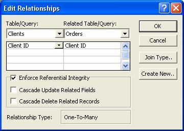
13 Referential Integrity Maintain data accuracy Prevents orphan records Keeps relationships intact PK FK October 5, 2014 ENGRG Intro to GIS 25 Referential Integrity October 5, 2014 ENGRG Intro to GIS 26 13
14 Form Analysis: Normalization Reduce Duplication Improve Accuracy Data Maintenance October 5, 2014 ENGRG Intro to GIS 27 Form Analysis: Normal Forms Notice the redundancies in this table Put database into the First Normal Form October 5, 2014 ENGRG Intro to GIS 28 14
15 First Normal Form Basically speaking is a rearrangement of data Redundant columns are removed Functional dependencies are rampant E.g., Tship_ID Tship_name, Thall_add Tship_ID = 12 always is named Birch and is located at latitude 15W Allows you to identify groups! Fields in the parcel dataset Parcels Parcel_ID Alderman Tship_ID Tship_name Thall_add Own_ID Own_name Own_add October 5, 2014 ENGRG Intro to GIS 29 First Normal Form October 5, 2014 ENGRG Intro to GIS 30 15
16 Second Normal Form Parcel_ID Alderman Tship_ID Tship_name Functional dependency reduced by splitting data into like groups, possibly establishing a table to define the relationship between the first two Thall_add Own_ID Own_name Own_add October 5, 2014 ENGRG Intro to GIS 31 Third Normal Form October 5, 2014 ENGRG Intro to GIS 32 16
 The emergence of spatial database changes the way.")
17 Third Normal Form Transitive functional dependencies are removed Parcel_ID Own_ID Parcel_ID Own_ID Alderman Tship_ID Own_name Own_add Tship_ID Tship_name Thall_add October 5, 2014 ENGRG Intro to GIS 33 Summary of Databases and GIS Most GIS packages still keep using hybrid solution: spatial data + attribute data (Arc+Info) The emergence of spatial database changes the way. Now many DBMS support spatial database: Oracle, DB2, MS SQL Server (commercial), and MySql, PostGreSql (open source) Geometric data Usually hierarchical Invisible to the user DBMS Geometric Spatial Data DBMS Attribute Attribute data Almost entirely relational Manipulated by the user October 5, 2014 ENGRG Intro to GIS 34 17

18 Attribute Data and Spatial Data Arc/Info: Hybrid name, the history of ArcGIS. Without attribute data, spatial data will be of limited use. October 5, 2014 ENGRG Intro to GIS 35 Geodatabase What is Geodatabase? Type of Geodatabase Geodatabase objects October 5, 2014 ENGRG Intro to GIS 36 18
 is a physical store of")
.")

 SQL Server Express Enterprise Geodatabase: 5 supported DBMSs: DB2,")
19 What is geodatabase? A geodatabase (short for geographic database) is a physical store of geographic information (spatial, attribute, metadata, and relationships) inside a relational database management system (RDBMS). October 5, 2014 ENGRG Intro to GIS 37 Geodatabase Types Since Ver9.2 Personal Geodatabase for Microsoft Access File Geodatabase (new since V9.2) Workgroup Geodatabase (new since V9.2) SQL Server Express Enterprise Geodatabase: 5 supported DBMSs: DB2, Informix, Oracle, MS SQl Server, PostgreSQL Increasing size and functionality October 5, 2014 ENGRG Intro to GIS 38 19


20 What does a Geodatabase look like? October 5, 2014 ENGRG Intro to GIS 39 What does a Geodatabase look like? October 5, 2014 ENGRG Intro to GIS 40 20
 October 5, 2014")


21 Personal GeoDatabase (Access) October 5, 2014 ENGRG Intro to GIS 41 Geodatabase (file based) October 5, 2014 ENGRG Intro to GIS 42 21

22 Geodatabase objects basic objects: feature classes, feature datasets, nonspatial tables. complex objects building on the basic objects: topology, relationship classes, geometric networks October 5, 2014 ENGRG Intro to GIS 43 Feature classes A feature class is a geographic feature include points, lines, polygons, and annotation feature class. Feature classes may exist independently in a geodatabase as standalone feature classes or you can group them into feature datasets The SouthAmerica geodatabase contains four stand-alone feature classes: a point feature class of cities, a dimension feature class of distances between cities, a polygon feature class of countries, and an annotation feature class of country names Source: October 5, 2014 ENGRG Intro to GIS 44 22
23 Feature datasets A feature dataset is composed of feature classes that have been grouped together so they can participate in topological relationships with each other. All the feature classes in a feature dataset must share the same spatial reference (or coordinate system) Edits you make to one feature class may result in edits being made automatically to some or all of the other feature classes in the feature dataset In the CityWater geodatabase, three point feature classes and one line feature class were grouped into the PublicWater feature dataset to create a geometric network called WaterNet. Source: October 5, 2014 ENGRG Intro to GIS 45 Tables Feature class tables and nonspatial attribute tables. Both types of tables are created and managed in ArcCatalog and edited in ArcMap. Both display in the traditional row and column format. The difference is that feature class tables have one or more columns that store feature geometry. Nonspatial tables contain only attribute data (no feature geometry) and display in ArcCatalog with the table icon. They can exist in a geodatabase as stand alone tables, or they can be related to other tables or feature classes. The cfcc_desc table in the SantaBarbara geodatabase contains attribute data for the Roads feature class (stored inside the Roads feature dataset). Source: October 5, 2014 ENGRG Intro to GIS 46 23

24 Organizing Geographic Features Feature: A geographic representation of a spatial object Features: One row in a table represents one feature Feature Classes: one table or more than one table Feature Dataset: a set of feature classes October 5, 2014 ENGRG Intro to GIS 47 GeoDatabase Elements Geodatabase Feature data set Geometric network Feature class Relationship class Table Annotation class October 5, 2014 ENGRG Intro to GIS 48 24


25 Topology In a GIS, spatial relationships among feature classes in a feature dataset are defined by topology. You can choose whether to create topology for features. The primary spatial relationships that you can model using topology are adjacency, coincidence, and connectivity There are three types of topology available in the geodatabase: geodatabase topology (over 20 topology rules), map topology, and geometric network topology. Each type of topology is created from feature classes that are stored within a feature dataset. A feature class can participate in only one topology at a time October 5, 2014 ENGRG Intro to GIS 49 Example of Topology in a Geodatabase October 5, 2014 ENGRG Intro to GIS 50 25

26 Geometric Networks In the real world, examples of networks abound: streams joining together to form larger streams, pipes carrying water to homes and businesses throughout a city, and power lines carrying electricity. In a geodatabase, you can model each of these real world networks with a geometric network. Starting with simple point and line feature classes, you use ArcCatalog to create a geometric network that will enable you to answer questions such as: Which streams will be affected by a proposed dam? Which areas will be affected by a water main repair? What is the quickest route between two points in the network? Source: October 5, 2014 ENGRG Intro to GIS 51 Geometric Network example Feature Classes Valve Service Feed Lateral Main Geometric Network Source: ESRI European User Conference October 5, 2014 ENGRG Intro to GIS 52 26

27 Relationship Classes In a geodatabase, relationship classes provide a way to model real world relationships that exist between objects such as parcels and buildings or streams and water sample data. By using relationship classes, you can make your GIS database more accurately reflect the real world and facilitate data maintenance. The relationships stored in a relationship class can be between two feature classes (such as buildings and parcels, top) or between a feature class and a nonspatial attribute table (such as streams and water quality sampling data, bottom). Source: October 5, 2014 ENGRG Intro to GIS 53 ESRI data models Provided by ESRI Goal: provide a practical template for implementing GIS projects Start to think about your final project now Great start point for your GIS project October 5, 2014 ENGRG Intro to GIS 54 27
 S 57 for ENC Census Administrative Boundaries Land Parcels Defense Intel Local Government Energy Utilities Energy Utilities MultiSpeak TM Marine Environmental Regulated Facilities")
28 Industry specific Data models Address Health Agriculture Historic Preservation and Archaeology Archiving Homeland Security Atmospheric Hydro Basemap International Hydrographic Biodiversity Organization (IHO) S 57 for ENC Census Administrative Boundaries Land Parcels Defense Intel Local Government Energy Utilities Energy Utilities MultiSpeak TM Marine Environmental Regulated Facilities National Cadastre Forestry Petroleum Geology Pipeline GIS for the nation Raster Groundwater Telecommunications Transportation Water Utilities From: October 5, 2014 ENGRG Intro to GIS 55 Data model: national GIS You can download it from ESRI website directly October 5, 2014 ENGRG Intro to GIS 56 28
29 Queries Definition Query is the action or result of selecting a subset of records based on specific attribute values General Categories: Attribute (Tabular) Spatial Two main methods: Boolean operators (AND, OR, NOT) SQL operators (< > + = )\ Structured querying language (SQL) The mathematical basis of relational databases led to a standard languages for querying data (SQL) that uses simple mathematical operators Relational databases allow the user to nest operations for complex queries October 5, 2014 ENGRG Intro to GIS 57 Database Use: Structured Query Language (SQL) Set Operators = Equal < > Not Equal <Less Than >Greater Than <= Less Than or Equal >= Greater Than or Equal Relational Operators Union Intersection Difference Product Aggregate Functions: Summarize Sum of values for all rows for a given column. Average of given column Column Maximum Column Minimum Number of Rows (Count) that Satisfy a Condition October 5, 2014 ENGRG Intro to GIS 58 29
30 A Nested SQL Statement Two Statements: Females / Pop1990 < 0.55, then Pop1990 > and Pop1990 < Or, one statement: (Females/Pop1990 < 0.55) and ((Pop1990 > ) and (Pop1990 < )) Compute all instances where the % of females in the 1990 population is less than 55% Then identify all population centers for the 1990 census where this true if these are larger than 100,000 and less than 200,000 October 5, 2014 ENGRG Intro to GIS 59 Spatial Queries Point Queries what is at a particular location? Range Queries what is in a particular area? Nearest Neighbor Queries where is the nearest object to a particular location? Spatial Join Queries where are the areas that have water supply and power supply? Spatial Aggregate Queries where is the most populated region? October 5, 2014 ENGRG Intro to GIS 60 30
31 Common Attribute Operations Queries selection operations that produce data subsets Join and Relate bringing data together (one table with non spatial attribute, one table with features) October 5, 2014 ENGRG Intro to GIS 61 Relations General Categories: Tabular based on some information within the attribute tables, e.g., a common field Spatial based on location: nearest, within or aggregate Geodatabase Relationship class Strategies Join Relate County Person Age Polygon_id = 157 Gpsid = 29 LC = Agriculture October 5, 2014 ENGRG Intro to GIS 62 31
32 Join vs. Relate Join Appends fields from second table with data for each record where a key field match is found (empty, otherwise) For 1:1 or M:1 only In 1:M or M:M, it stops with first hit (can t add rows/records for additional relationships) Relate Allows automatic access to a related table s records; keep tables physically separate For 1:M or M:M Doesn t add records to layer s table, so not limited by initial table s size Forest- ID ForestName 1 Nantahala 2 Cherokee Forest-ID Trail_Name Features Trailhead 1 Bryson's Knob Vista X1, Y1 2 Slickrock Falls Ogrth X2, Y2 1 North Fork Wfall X3, Y3 2 Cade's Cave Wlife X4, Y4 1 Appalachian Cmp X5, Y5 October 5, 2014 ENGRG Intro to GIS 63 Spatial Join Related two attribute tables via a shared location in space, rather than common field Concept: A type of join operation in which fields from one layer s attribute table are appended to another layer s attribute table based on the relative locations of the features in the two layers. Examples Finding the nearest feature Finding what's inside a polygon Finding what intersects a feature Where is there an incompatibility between zoning and current land use? How many Toxic Release Inventory sites are there in each county and what are the total releases per county? October 5, 2014 ENGRG Intro to GIS 64 32

: select state, sum(pop) as citypop, count(city) as totalcity from")
33 Spatial Join URL: more%20about%20spatial%20relationships October 5, 2014 ENGRG Intro to GIS 65 Spatial Join: An example Input layers: Population in US cities; US states; Object: the city population in each state; how many cities in each state; Solutions: Count/summarize manually? Simple Query in DBMS (very easy but limited by data organization in many cases): select state, sum(pop) as citypop, count(city) as totalcity from cities group by state Spatial join October 5, 2014 ENGRG Intro to GIS 66 33


34 Spatial Join Example October 5, 2014 ENGRG Intro to GIS 67 What did we learn today? Introduction to Database Management System (DBMS) 4 types DBMS Relational Database Basics 2 keys 3 relations Data Normalization Form analysis Spatial Database Overview and Operation Join vs relate Spatial join October 5, 2014 ENGRG Intro to GIS 68 34
ENGRG Introduction to GIS
 ENGRG 59910 Introduction to GIS Michael Piasecki October 06, 2017 Lecture 05: GIS and Database Basics Where are we now? Basic geographic concepts Introduction to GIS, coordinate system, projection, datum
ENGRG 59910: Introduction to GIS
 ENGRG 59910: Introduction to GIS Lecture 05: GIS and Databases Basics Acknowledgment: Michael Piasecki Where are we now? Basic geographic concepts Introduction to GIS, coordinate system, projection, datum
Facilities Management Data Input, Editing and Management. Adrien Litton
 Facilities Management Data Input, Editing and Management Adrien Litton Overview What is FM in GIS? Data input Data editing Data management Supporting the Real Property Life-Cycle GIS Integrates the Facility
Using the Geodatabase
 Using the Geodatabase February 13, 2002 Presented by: John Stroud, ESRI GeoDatabase Geodatabase comes in two flavors Personal mdb format ArcSDE rdbms format ArcGIS is a suite of three products ArcView,
Introduction to Geodatabase and Spatial Management in ArcGIS. Craig Gillgrass Esri
 Introduction to Geodatabase and Spatial Management in ArcGIS Craig Gillgrass Esri Session Path The Geodatabase - What is it? - Why use it? - What types are there? - What can I do with it? Query Layers
Key Terms. Attribute join Target table Join table Spatial join
 Key Terms Attribute join Target table Join table Spatial join Lect 10A Building Geodatabase Create a new file geodatabase Map x,y data Convert shape files to geodatabase feature classes Spatial Data Formats
LSGI 521: Principles of GIS. Lecture 5: Spatial Data Management in GIS. Dr. Bo Wu
 Lecture 5: Spatial Data Management in GIS Dr. Bo Wu lsbowu@polyu.edu.hk Department of Land Surveying & Geo-Informatics The Hong Kong Polytechnic University Contents 1. Learning outcomes 2. From files to
Introduction to Geographic Information Science. Updates. Last Lecture. Geography 4103 / Database Management
 Geography 4103 / 5103 Introduction to Geographic Information Science Database Management Updates Last Lecture We tried to explore the term spatial model by looking at definitions, taxonomies and examples
Homework 2; Down load instructions and data from Web Can load.dbf in to ArcMap and use Select by Attributes
 Homework 2; Down load instructions and data from Web Can load.dbf in to ArcMap and use Select by Attributes Submit via Moodle using HomeWork2 Answer Sheet Quiz Homework on Website Homework 2; Down load
For each layer there is typically a one- to- one relationship between geographic features (point, line, or polygon) and records in a table
 and records in a table") For each layer there is typically a one- to- one relationship between geographic features (point, line, or polygon) and records in a table Common components of a database: Attribute (or item or field)
For each layer there is typically a one- to- one relationship between geographic features (point, line, or polygon) and records in a table Common components of a database: Attribute (or item or field)
Why use an RDBMS? ❽ Data maintenance ❽ Standardized access ❽ Multi-user access ❽ Data protection
 1 Why use an RDBMS? ❽ Data maintenance ❽ Standardized access ❽ Multi-user access ❽ Data protection 2 RDBMSs offer Data protection ❽ Recovery ❽ Concurrency ❽ Security 3 Data protection ❽ Recovery from ❽
Geodatabases. Dr. Zhang SPRING 2016 GISC /03/2016
 Geodatabases Dr. Zhang SPRING 2016 GISC 1401 10/03/2016 Using and making maps Navigating GIS maps Map design Working with spatial data Spatial data infrastructure Interactive maps Map Animations Map layouts
Editing Versioned Geodatabases : An Introduction
 Esri International User Conference San Diego, California Technical Workshops July 24, 2012 Editing Versioned Geodatabases : An Introduction Cheryl Cleghorn Shawn Thorne Assumptions: Basic knowledge of
Lesson 2: Data Models, Database Models, and Data Modeling GEOG482/582 / My Course / University of Washington
 http://www.state.gov/cms_images/discussion.gif GEOG 482/582: GIS Data Management Lesson 2: Data Models, Database Models, and Data Modeling Overview Learning Objective Questions: 1. Why use three realms
Welcome to NR402 GIS Applications in Natural Resources. This course consists of 9 lessons, including Power point presentations, demonstrations,
 Welcome to NR402 GIS Applications in Natural Resources. This course consists of 9 lessons, including Power point presentations, demonstrations, readings, and hands on GIS lab exercises. Following the last
Lecture 8. Database Management and Queries
 Lecture 8 Database Management and Queries Lecture 8: Outline I. Database Components II. Database Structures A. Conceptual, Logical, and Physical Components III. Non-Relational Databases A. Flat File B.
ArcMap - EXPLORING THE DATABASE Part I. SPATIAL DATA FORMATS Part II
 Week 5 ArcMap - EXPLORING THE DATABASE Part I SPATIAL DATA FORMATS Part II topics of the week Exploring the Database More on the Table of Contents Exploration tools Identify, Find, Measure, Map tips, Hyperlink,
Object modeling and geodatabases. GEOG 419: Advanced GIS
 Object modeling and geodatabases GEOG 419: Advanced GIS CAD Data Model 1960s and 1970s Geographic data stored as points, lines, and areas No attributes; each feature type stored on a different layer No
Utility Network Management in ArcGIS: Migrating Your Data to the Utility Network. John Alsup & John Long
 Utility Network Management in ArcGIS: Migrating Your Data to the Utility Network John Alsup & John Long Presentation Outline Utility Network Preparation - Migration Patterns - Understanding the Asset Package
Lecturer 2: Spatial Concepts and Data Models
 Lecturer 2: Spatial Concepts and Data Models 2.1 Introduction 2.2 Models of Spatial Information 2.3 Three-Step Database Design 2.4 Extending ER with Spatial Concepts 2.5 Summary Learning Objectives Learning
Tutorial 1: Finding and Displaying Spatial Data Using ArcGIS
 Tutorial 1: Finding and Displaying Spatial Data Using ArcGIS This tutorial will introduce you to the following: Websites where you may browse to find geospatial information Identifying spatial data, usable
Introduction to ArcSDE 8. John Calkins
 Introduction to ArcSDE 8 John Calkins Why are you here? Introduction to ArcSDE? What is a GeoDatabase? Existing SDE user? Existing ArcInfo user? Technical details on implementation? Just confused... ArcSDE
Lecture 6: GIS Spatial Analysis. GE 118: INTRODUCTION TO GIS Engr. Meriam M. Santillan Caraga State University
 Lecture 6: GIS Spatial Analysis GE 118: INTRODUCTION TO GIS Engr. Meriam M. Santillan Caraga State University 1 Spatial Data It can be most simply defined as information that describes the distribution
Compass INSPIRE Services. Compass INSPIRE Services. White Paper Compass Informatics Limited Block 8, Blackrock Business
 Compass INSPIRE Services White Paper 2010 Compass INSPIRE Services Compass Informatics Limited Block 8, Blackrock Business Park, Carysfort Avenue, Blackrock, County Dublin, Ireland Contact Us: +353 1 2104580
Announcements. Data Sources a list of data files and their sources, an example of what I am looking for:
 Data Announcements Data Sources a list of data files and their sources, an example of what I am looking for: Source Map of Bangor MEGIS NG911 road file for Bangor MEGIS Tax maps for Bangor City Hall, may
GIS Workbook #1. GIS Basics and the ArcGIS Environment. Helen Goodchild
 GIS Basics and the ArcGIS Environment Helen Goodchild Overview of Geographic Information Systems Geographical Information Systems (GIS) are used to display, manipulate and analyse spatial data (data that
Understanding ArcSDE. GIS by ESRI
 Understanding ArcSDE GIS by ESRI Copyright 1999, 2001 2002 ESRI All rights reserved Printed in the United States of America The information contained in this document is the exclusive property of ESRI
Massachusetts Institute of Technology Department of Urban Studies and Planning
 Massachusetts Institute of Technology Department of Urban Studies and Planning 11.204: Planning, Communication, and Digital Media Fall 2004 Recitation 6: Using Access to Query Multiple Data Sets 1. What
GIS Basics for Urban Studies
 GIS Basics for Urban Studies Date: March 21, 2018 Contacts: Mehdi Aminipouri, Graduate Peer GIS Faciliator, SFU Library (maminipo@sfu.ca) Keshav Mukunda, GIS & Map Librarian Librarian for Geography (kmukunda@sfu.ca)
Introduction to ArcCatalog
 Introduction to ArcCatalog Introduction To Arc Catalog ArcCatalog is a data- centric GUI tool used for managing spatial data With ArcCatalog you can. Inspect properties and attributes of data Preview and
Linear Referencing in ArcGIS : Practical Considerations for the Development of an Enterprisewide GIS
 Linear Referencing in ArcGIS : Practical Considerations for the Development of an Enterprisewide GIS An ESRI Technical Paper April 2003 ESRI 380 New York St., Redlands, CA 92373-8100, USA TEL 909-793-2853
Esri s ArcGIS Enterprise. Today s Topics. ArcGIS Enterprise. IT4GIS Keith T. Weber, GISP GIS Director ISU GIS Training and Research Center
 Esri s ArcGIS Enterprise IT4GIS Keith T. Weber, GISP GIS Director ISU GIS Training and Research Center Today s Topics Part 1: ArcGIS Enterprise architecture Part 2: Storing and serving data for the enterprise
Vector Data. James Frew ESM 263 Winter
 Vector Data 1 Why Vector Data? Recall: features vs fields features: discrete enffes with specific locafons fields: confnuous funcfons of (x, y) Vector is GIS-speak for feature representafons dimensionality:
AGIC 2012 Workshop Leveraging Free RDBMS in ArcGIS
 AGIC 2012 Workshop Leveraging Free RDBMS in ArcGIS Prescott, AZ October 2012 Instructors: Bo Guo, PE, PhD Terry Li Workshop Outline Part I Introduction Why RDBMS Discussion on Obstacles for using RDBMS
Class #2. Data Models: maps as models of reality, geographical and attribute measurement & vector and raster (and other) data structures
 data structures") Class #2 Data Models: maps as models of reality, geographical and attribute measurement & vector and raster (and other) data structures Role of a Data Model Levels of Data Model Abstraction GIS as Digital
Class #2 Data Models: maps as models of reality, geographical and attribute measurement & vector and raster (and other) data structures Role of a Data Model Levels of Data Model Abstraction GIS as Digital
What s New in Desktop 10.1
 What s New in Desktop 10.1 Damian Spangrud Esri Redlands Trip Down Memory Lane ArcGIS A Complete System for Geographic Information Cloud Web Online Mobile Enterprise Desktop Sharing Information sharing
Topic 5: Raster and Vector Data Models
 Geography 38/42:286 GIS 1 Topic 5: Raster and Vector Data Models Chapters 3 & 4: Chang (Chapter 4: DeMers) 1 The Nature of Geographic Data Most features or phenomena occur as either: discrete entities
Data, Information, and Databases
 Data, Information, and Databases BDIS 6.1 Topics Covered Information types: transactional vsanalytical Five characteristics of information quality Database versus a DBMS RDBMS: advantages and terminology
Understanding Geospatial Data Models
 Understanding Geospatial Data Models 1 A geospatial data model is a formal means of representing spatially referenced information. It is a simplified view of physical entities and a conceptualization of
Chapter 2: Spatial Concepts and Data Models 2.1 Introduction 2.2 Models of Spatial Information. 2.4 Extending ER with Spatial Concepts 2.
 Chapter 2: Spatial Concepts and Data Models 2. Introduction 2.2 Models of Spatial Information 2.3 Three-Step Database Design 2.4 Extending ER with Spatial Concepts 2.5 Summary What is a Data Model? What
GEOGRAPHIC INFORMATION SYSTEMS Lecture 18: Spatial Modeling
 Spatial Analysis in GIS (cont d) GEOGRAPHIC INFORMATION SYSTEMS Lecture 18: Spatial Modeling - the basic types of analysis that can be accomplished with a GIS are outlined in The Esri Guide to GIS Analysis
Mid-term exam. GIS and Forest Engineering Applications. Week 5. FE 257. GIS and Forest Engineering Applications. Week 5
 FE 257. GIS and Forest Engineering Applications Week 5 Week 5 Last week (Chapter 3): Acquiring, creating, and editing GIS s Examining Error Chapter 7 Buffering and other proximity operations Questions?
Esri s Spatial Database Engine. Today s Topics. ArcSDE. A spatial database engine that works on
 Esri s Spatial Database Engine IT4GIS Keith T. Weber, GISP GIS Director ISU GIS Training and Research Center Today s Topics Part 1: What is ArcSDE? Why use ArcSDE? ArcSDE Data Structure How is data stored
Georeferencing. Georeferencing: = linking a layer or dataset with spatial coordinates. Registration: = lining up layers with each other
 Georeferencing How do we make sure all our data layers line up? Georeferencing: = linking a layer or dataset with spatial coordinates Registration: = lining up layers with each other Rectification: The
DATABASE MANAGEMENT SYSTEMS. UNIT I Introduction to Database Systems
 DATABASE MANAGEMENT SYSTEMS UNIT I Introduction to Database Systems Terminology Data = known facts that can be recorded Database (DB) = logically coherent collection of related data with some inherent
Lab Assignment 4 Basics of ArcGIS Server. Due Date: 01/19/2012
 Lab Assignment 4 Basics of ArcGIS Server Due Date: 01/19/2012 Overview This lab assignment is designed to help you develop a good understanding about the basics of ArcGIS Server and how it works. You will
What's New in ArcGIS 9.2 Service Packs
 What's New in ArcGIS 9.2 Service Packs 18 July 2007 Updated for Service Pack 3 This document describes the main enhancements to 9.2 added by the service packs. It does not cover the bug fixes and quality
Introduction to GIS & Mapping: ArcGIS Desktop
 Introduction to GIS & Mapping: ArcGIS Desktop Your task in this exercise is to determine the best place to build a mixed use facility in Hudson County, NJ. In order to revitalize the community and take
Data Assembly, Part II. GIS Cyberinfrastructure Module Day 4
 Data Assembly, Part II GIS Cyberinfrastructure Module Day 4 Objectives Continuation of effective troubleshooting Create shapefiles for analysis with buffers, union, and dissolve functions Calculate polygon
Coverage data model. Vector-Based Spatial Analysis: Tools Processes. Topological Data Model. Polygons Files. Geographic Information Systems.
 GEOG4340 Geographic Information Systems Lecture Four 2013winter Vector-Based Spatial Analysis: Tools Processes Reading materials: Chapter 6 of Intro GIS by J. R. Jensen and R.R. Jensen Cheng. Q., Earth
IST 210. Introduction to Spatial Databases
 Introduction to Spatial Databases Evolution of acronym GIS Geographic Information Systems (1980s) Geographic Information Science (1990s) Geographic Information Services (2000s) GISystems GIServices GIScience
Introducing ArcScan for ArcGIS
 Introducing ArcScan for ArcGIS An ESRI White Paper August 2003 ESRI 380 New York St., Redlands, CA 92373-8100, USA TEL 909-793-2853 FAX 909-793-5953 E-MAIL info@esri.com WEB www.esri.com Copyright 2003
Name: Date: June 27th, 2011 GIS Boot Camps For Educators Lecture_3
 Name: Date: June 27th, 2011 GIS Boot Camps For Educators Lecture_3 Practical: Creating and Editing Shapefiles Using Straight, AutoComplete and Cut Polygon Tools Use ArcCatalog to copy data files from:
Municipal Parcel Mapping Workshop
 Municipal Parcel Mapping Workshop Presented to: Ontario Municipalities Presented by: Dave Gariepy, Director of Platform Content Dave Horwood, Land Information Systems Architect Sarah Sibbett, Senior Parcel
Office of Geographic Information Systems
 Office of Geographic Information Systems Print this Page Summer 2011 - Desktop GIS: You Want More Data? By Joe Sapletal, GISP In the Summer 2010 Tech Talk article ArcGIS Services, we addressed connecting
Leveraging SAP HANA and ArcGIS. Melissa Jarman Eugene Yang
 Melissa Jarman Eugene Yang Outline SAP HANA database ArcGIS Support for HANA Database access Sharing via Services Geodatabase support Demo SAP HANA In-memory database Support for both row and column store
Building an Enterprise GeoDatabase to Support a Service Oriented Architecture
 Dan Widner VDOT Dan.Widner@vdot.virginia.gov Paul Bucher Keane, Inc Paul.Bucher@vdot.virginia.gov Historical Perspective and Vision Technical Approach Historical Perspective and Vision A Bit of History
Exercise 3: Creating a Geodatabase
 Exercise 3: Creating a Geodatabase Introduction: A database (DB) is an organized collection of data, that we can visualize as being a group of tables. An example of a simple database can be seen below:
Basic Geospatial Analysis Techniques: This presentation introduces you to basic geospatial analysis techniques, such as spatial and aspatial
 Basic Geospatial Analysis Techniques: This presentation introduces you to basic geospatial analysis techniques, such as spatial and aspatial selections, buffering and dissolving, overly operations, table
Data Models and SQL for GIS. John Porter Department of Environmental Sciences University of Virginia
 Data Models and SQL for GIS John Porter Department of Environmental Sciences University of Virginia Why Talk about Databases in a GIS Class? The goal of GIS is to analyze and display spatial data Vector
Chapter 1: Introduction to Spatial Databases
 Chapter 1: Introduction to Spatial Databases 1.1 Overview 1.2 Application domains 1.3 Compare a SDBMS with a GIS 1.4 Categories of Users 1.5 An example of an SDBMS application 1.6 A Stroll though a spatial
presented by: Tim Haithcoat University of Missouri Columbia
 12 presented by: Tim Haithcoat University of Missouri Columbia Introduction Very early attempts to build GIS began from scratch, using limited tools like operating systems & compilers More recently, GIS
Vector-Based GIS Data Processing. Chapter 6
 Vector-Based GIS Data Processing Chapter 6 Vector Data Model Feature Classes points lines polygons Layers limited to one class of data Figure p. 186 Vector Data Model Shapefiles ArcView non-topological
Databases. Managing Data for Retrieval, Update, & Calculation. Drilling Record ID Name Spudded Completed. 40 Exxon #1 2/4/96 6/3/96
 Databases Managing Data for Retrieval, Update, & Calculation Drilling Record ID Name Spudded Completed 40 Exxon #1 2/4/96 6/3/96 43 Shell #5 3/14/97 6/12/96 Production (barrels/day, cfs) ID Oil Gas Water
Copyright The McGraw-Hill Companies, Inc. Permission required for reproduction or display.
 CHAPTER 11 VECTOR DATA ANALYSIS 11.1 Buffering 11.1.1 Variations in Buffering Box 11.1 Riparian Buffer Width 11.1.2 Applications of Buffering 11.2 Overlay 11.2.1 Feature Type and Overlay 11.2.2 Overlay
hereby recognizes that Timotej Verbovsek has successfully completed the web course 3D Analysis of Surfaces and Features Using ArcGIS 10
 3D Analysis of Surfaces and Features Using ArcGIS 10 Completed on September 5, 2012 3D Visualization Techniques Using ArcGIS 10 Completed on November 19, 2011 Basics of Map Projections (for ArcGIS 10)
An Esri White Paper July 2010 Use GIS Data ReViewer to Inspect ArcFM Feeder Manager Circuits
 An Esri White Paper July 2010 Use GIS Data ReViewer to Inspect ArcFM Feeder Manager Circuits Esri, 380 New York St., Redlands, CA 92373-8100 USA TEL 909-793-2853 FAX 909-793-5953 E-MAIL info@esri.com WEB
Design a Geodatabase. Rasu Muthurakku, Enterprise Solutions Architect / Consultant
 Rasu Muthurakku, Enterprise Solutions Architect / Consultant Agenda Overview Key Factors Design - Recommendations Key Considerations, Best Practices and Recommendations / Lessons Learned! Overview What
ArcGIS 10.1 for Desktop Artie Robinson
 ArcGIS 10.1 for Desktop Artie Robinson ArcGIS A Complete System for Geographic Information Cloud Web Online Mobile Enterprise Desktop Name Change Name Prior to 10.1 ArcGIS Desktop ArcInfo ArcEditor ArcView
GIS LAB 1. Basic GIS Operations with ArcGIS. Calculating Stream Lengths and Watershed Areas.
 GIS LAB 1 Basic GIS Operations with ArcGIS. Calculating Stream Lengths and Watershed Areas. ArcGIS offers some advantages for novice users. The graphical user interface is similar to many Windows packages
Graphic Display of Vector Object
 What is GIS? GIS stands for Geographic Information Systems, although the term Geographic Information Science is gaining popularity. A GIS is a software platform for storing, organizing, viewing, querying,
The Oracle Enterprise Geodatabase (EGDB) Charlie Crocker Farallon Geographics, Inc.
 Charlie Crocker Farallon Geographics, Inc.") The Oracle Enterprise Geodatabase (EGDB) Charlie Crocker Farallon Geographics, Inc. www.fargeo.com Norcal URISA Chapter Meeting 2/9/2005 Todays Goals Enterprise geodatabase defined Roles Oracle can play
The Oracle Enterprise Geodatabase (EGDB) Charlie Crocker Farallon Geographics, Inc. www.fargeo.com Norcal URISA Chapter Meeting 2/9/2005 Todays Goals Enterprise geodatabase defined Roles Oracle can play
Watershed Sciences 4930 & 6920 GEOGRAPHIC INFORMATION SYSTEMS
 Watershed Sciences 4930 & 6920 GEOGRAPHIC INFORMATION SYSTEMS WATS 4930/6920 WHERE WE RE GOING WATS 6915 welcome to tag along for any, all or none WEEK FIVE Lecture VECTOR ANALYSES Joe Wheaton HOUSEKEEPING
GEOGRAPHIC INFORMATION SYSTEMS Lecture 02: Feature Types and Data Models
 GEOGRAPHIC INFORMATION SYSTEMS Lecture 02: Feature Types and Data Models Feature Types and Data Models How Does a GIS Work? - a GIS operates on the premise that all of the features in the real world can
What's New in ArcGIS 9.2 Service Packs
 What's New in ArcGIS 9.2 Service Packs 8 July 2008 Updated for Service Pack 6 This document describes the main enhancements to 9.2 added by the service packs. It does not cover the bug fixes and quality
GIS Data Recap. Databases HOW? Spatial Databases 2/4/2016. GEO327G/386G, UT Austin 1. GIS = Lots and Lots of Tabular Data. Goals:
 Databases GIS Data Recap Managing Data for Retrieval, Update, & Calculation ID Name Spudded Completed 40 Exxon #1 2/4/96 6/3/96 Production (barrels/day, cfs) 43 Shell #5 3/14/97 6/12/96 ID Oil Gas Water
Making ArcGIS Work for You. Elizabeth Cook USDA-NRCS GIS Specialist Columbia, MO
 Making ArcGIS Work for You Elizabeth Cook USDA-NRCS GIS Specialist Columbia, MO 1 Topics Using ArcMap beyond the Toolkit buttons GIS data formats Attributes and what you can do with them Calculating Acres
Streamlining Editing Workflows. Amber Bethell
 Streamlining Editing Workflows Amber Bethell Workflow for solving geographic problems Ask a question Create or acquire data Validate and update data Analyze data Create cartographic product Act upon knowledge
Data, Databases, and DBMSs
 Todd S. Bacastow January 2004 IST 210 Data, Databases, and DBMSs 1 Evolution Ways of storing data Files ancient times (1960) Databases Hierarchical (1970) Network (1970) Relational (1980) Object (1990)
LAB 1: Introduction to ArcGIS 8
 LAB 1: Introduction to ArcGIS 8 Outline Introduction Purpose Lab Basics o About the Computers o About the software o Additional information Data ArcGIS Applications o Starting ArcGIS o o o Conclusion To
ENGRG Introduction to GIS
 ENGRG 59910 Introduction to GIS Michael Piasecki April 3, 2014 Lecture 11: Raster Analysis GIS Related? 4/3/2014 ENGRG 59910 Intro to GIS 2 1 Why we use Raster GIS In our previous discussion of data models,
Lesson 12: ArcGIS Server Capabilities
 GEOG 482 / 582 : GIS Data Management Lesson 12: ArcGIS Server Capabilities Overview Learning Objective Questions: 1. What are the ArcGIS Server Services? 2. How is ArcGIS Server packaged? 3. What are three
ArcGIS Pro Editing. Jennifer Cadkin & Phil Sanchez
 ArcGIS Pro Editing Jennifer Cadkin & Phil Sanchez ArcGIS Pro Editing Overview Provides tools that allow you to maintain, update, and create new data - Modifying geometry, drawing new features - Entering
GITA 338: Spatial Information Processing Systems
 GITA 338: Spatial Information Processing Systems Sungwon Jung Dept. of Computer Science and Engineering Sogang University Seoul, Korea Tel: +82-2-705-8930 Email : jungsung@sogang.ac.kr Spatial Query Languages
ArcGIS Network Analyst and Network Dataset. Jim McKinney ESRI
 ArcGIS Network Analyst and Network Dataset Jim McKinney ESRI ArcGIS Network Analyst Everything in ArcView GIS 3x and more Routing Directions Network Analysis Tight Integration with Geoprocessing Models
Watershed Sciences 4930 & 6920 ADVANCED GIS
 Slides by Wheaton et al. (2009-2014) are licensed under a Creative Commons Attribution-NonCommercial-ShareAlike 3.0 Unported License Watershed Sciences 4930 & 6920 ADVANCED GIS VECTOR ANALYSES Joe Wheaton
Systems Analysis and Design in a Changing World, Fourth Edition. Chapter 12: Designing Databases
 Systems Analysis and Design in a Changing World, Fourth Edition Chapter : Designing Databases Learning Objectives Describe the differences and similarities between relational and object-oriented database
Montana Department of Transportation (MDT) Location/Linear Referencing System (LLRS) Design Process
 Location/Linear Referencing System (LLRS) Design Process") Montana Department of Transportation (MDT) Location/Linear Referencing System (LLRS) Design Process Marlin Sander, MDT and Bill Schuman, GeoDecisions Session Outline Current MDT s transportation inventory
Montana Department of Transportation (MDT) Location/Linear Referencing System (LLRS) Design Process Marlin Sander, MDT and Bill Schuman, GeoDecisions Session Outline Current MDT s transportation inventory
Designing and Using Basemaps. Jennifer Hughey
 Designing and Using Basemaps Jennifer Hughey Agenda The ArcGIS System Basemaps are a key component of your system Cartographic design considerations Using basemap layers in ArcMap Best practices for designing
TABLES, ANATOMY OF A TABLE
 week 6 TABLES, ANATOMY OF A TABLE topics of the week Table structure Working with tables Table relationships Cardinality, Joins and Relates Table Jargon What is a Database? What is a Table? What is a Record/Row?
Answer the following general questions: 1. What happens when you right click on an icon on your desktop? When you left double click on an icon?
 Name: Date: June 27th, 2011 GIS Boot Camps For Educators Practical: Explore ArcGIS 10 Desktop Tools and functionality Day_1 Lecture 1 Sources: o ArcGIS Desktop help o ESRI website o Getting to Know ArcGIS
LECTURE 2 SPATIAL DATA MODELS
 LECTURE 2 SPATIAL DATA MODELS Computers and GIS cannot directly be applied to the real world: a data gathering step comes first. Digital computers operate in numbers and characters held internally as binary
INTRODUCTION TO GIS WORKSHOP EXERCISE
 111 Mulford Hall, College of Natural Resources, UC Berkeley (510) 643-4539 INTRODUCTION TO GIS WORKSHOP EXERCISE This exercise is a survey of some GIS and spatial analysis tools for ecological and natural
Data Assembling Topics:
 Topics: 1. GPX to Shape file 2. Data conversion with FME 3. Create a polygon feature 4. Merging /Appending data into a new dataset 5. Reproject data from one coordinate system to another 6. Data clipping
CS317 File and Database Systems
 CS317 File and Database Systems Lecture 3 Relational Model & Languages Part-1 September 7, 2018 Sam Siewert More Embedded Systems Summer - Analog, Digital, Firmware, Software Reasons to Consider Catch
Multidimensional Data and Modelling - DBMS
 Multidimensional Data and Modelling - DBMS 1 DBMS-centric approach Summary: l Spatial data is considered as another type of data beside conventional data in a DBMS. l Enabling advantages of DBMS (data
Geog 469 GIS Workshop. System Requirements - Data
 Geog 469 GIS Workshop System Requirements - Data Outline 1. What are some principles of project management? 2. What are some fundamental issues associated with system requirements? 3. What are some issues
Introduction to ArcGIS for Brushy Creek
 Introduction to ArcGIS for Brushy Creek Course exercise for CE 374K Hydrology University of Texas at Austin Prepared by Sili Liu and David R. Maidment January, 2012 DESCRIPTION A geographic information
layers in a raster model
 layers in a raster model Layer 1 Layer 2 layers in an vector-based model (1) Layer 2 Layer 1 layers in an vector-based model (2) raster versus vector data model Raster model Vector model Simple data structure
ArcSDE architecture and connections
 ArcSDE architecture and connections Lesson overview ArcSDE system components Application Server Connections Direct Connect Geodatabase properties ArcSDE versions What is a version ArcIMS and versions 6-2