MANAGEMENT OF IPY 2007/08 NATIONAL DATA
|
|
|
- Jack Sherman
- 5 years ago
- Views:
Transcription

1 SAON MANAGEMENT OF IPY 2007/08 NATIONAL DATA M.Shaimardanov, A.Sterin, Nickolay Mikhailov, Alexander Kuznetsov, Eugeny Vyazilov R I H M I W D C


2 The scientific programme for participation of Russian Federation in the International Polar Year 2007/ scientific and observational projects; - 70 institutions; -150 terrestrial and marine expeditions. Themes of scientific programme 1 Hydrometeorology and solar geophysics 2 Geology 3 Marine and terrestrial ecosystems 4 Development of observational network 5 Data management, information system, cartography 6 Social and economical development 7 Education and science 8 Outreach and publicity
3 National IPY data access and management system - Regulatory documents, manuals and guidelines - Technological tools for data and metadata collection and exchange; - WEB portal IPY-INFO INFO Data management Policy within the framework of scientific programme for participation of Russian Federation in the International Polar Year 2007/08 IPY 2007/08 Data Management Plan Manual for data and metadata compiling Specification of data exchange format Guideline for entry metadata into IPY-Info
 Expedition Expedition")
4 SCHEME OF NATIONAL IPY DATA COLLECTION AND EXCHANGE IPYDIS IPY- Info National IPY Data Centres Metadata Data Data Users Institutions (IPY( IPY projects) Expedition Expedition Expedition
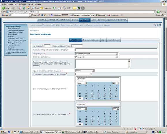
5 Level_ 0: Expeditions BASIC FUNCTIONS OF DATA PROCESSING AND EXCHANGE compiling disciplinary data sets --> institutions filling in the CSR form ---> principal institution Level_ 1: Institutions (IPY projects) compiling observed metadata and entry ---> IPY-Info & IPYDIS compiling metadata for value-added products and entry ---> IPY-Info & IPYDIS entry CSR ---> IPY-Info converting data to standard formats and loading--> IPY-Info Data center Level_2: IPY Data Centres expertise of metadata and data -- IPY-Info complete integrated data sets and relevant metadata --> IPY-Info & IPYDIS monitoring of the disciplinary data flow ensure long-term preservation of the data access to data via E2E DDB or via own WEB site ----> IPY-Info


6 Technologies for DM Data collection and preprocessing Specification of data exchange format Manual for data and metadata compiling Data packet Metadata *[Общие характеристики] Integration and remote access WEB-portal IPY-Info. Manual on technology Guideline for entry data and metadata into IPY-Info Manual on E2E integration technology
![Format standards for the data and metadata Metadata *[Common attributes] Data packet [Name] Operational meteorological data *[Common attributes] [Title] Deep-sea XCTD data of 22 cruise R/V](/docs-images/88/116965716/images/7-1.jpg "«Polarstern» (IPR) [Summary] Temperature and salinity soundings at 0.")
![1 m intervals in the Arctic EEZ of Russian Federation [Geographic area] Kara sea, Laptev Sea [Format] Text CSV format for environmental data [Start date] 26-08-2007 [Stop date] 13-09-2007 [Temporal](/docs-images/88/116965716/images/7-3.jpg "resolution] irregular - from hour to days [Spatial resolution] about 10-15 miles [Order sequence] date, depth [Parameters] Presssure, Temperature, Salinity [Data files] E294O2_Polarstern_22_H13.")
7 Format standards for the data and metadata Metadata *[Common attributes] Data packet [Name] Operational meteorological data *[Common attributes] [Title] Deep-sea XCTD data of 22 cruise R/V «Polarstern» (IPR) [Summary] Temperature and salinity soundings at 0.1 m intervals in the Arctic EEZ of Russian Federation [Geographic area] Kara sea, Laptev Sea [Format] Text CSV format for environmental data [Start date] [Stop date] [Temporal resolution] irregular - from hour to days [Spatial resolution] about miles [Order sequence] date, depth [Parameters] Presssure, Temperature, Salinity [Data files] E294O2_Polarstern_22_H13.met metadata E294O2_Polarstern_22_H13_pos.csv position and time data E294O2_Polarstern_22_H13_D01.csv soundings data [Source] R/V «Polarstern» (Ãåðìàíèÿ), 22 ðåéñ [PI] Chief Scientist Dr. Ursula Schauer, institute FOR MARINE AND POLAR RESEARCH *[Additional attributes] [Instruments] XCTD Sea-Bird [Processing method] unknown [Completness] 100% for EEZ [Volume] 11.0 Mb, 21 soundings (21 data file)
8 Data hierarchy Cruise;Station;Type;YYYY-MM-DDThh:mm;Longitude;Latitude;Bot. Depth 14828;10;; T14:00;-46,500;48,333;954;0,0;;1,180;33,128; 14828;10;; T14:00;-46,500;48,333;954;9,0;;1,949;33,363; 14828;10;; T14:00;-46,500;48,333;954;19,0;;1,800;33,476; 14828;10;; T14:00;-46,500;48,333;954;28,0;;1,779;33,476; 14828;10;; T14:00;-46,500;48,333;954;46,0;;0,560;33,921; 14828;10;; T14:00;-46,500;48,333;954;70,0;;0,930;34,116; 14828;10;; T14:00;-46,500;48,333;954;94,0;;1,159;34,224; 14828;10;; T14:00;-46,500;48,333;954;100,0;;1,330;34,257; 14828;10;; T14:00;-46,500;48,333;954;142,0;;2,560;34,497; 14828;10;; T14:00;-46,500;48,333;954;192,0;;2,270;34,532; 14828;10;; T14:00;-46,500;48,333;954;238,0;;2,939;34,619; 14828;10;; T14:00;-46,500;48,333;954;284,0;;2,419;34,734; 14828;10;; T14:00;-46,500;48,333;954;378,0;;3,879;34,861; 14828;10;; T14:00;-46,500;48,333;954;400,0;;3,870;34,869; 14828;10;; T14:00;-46,500;48,333;954;472,0;;3,819;34,893; 14828;10;; T14:00;-46,500;48,333;954;570,0;;3,819;34,893; 14828;10;; T14:00;-46,500;48,333;954;762,0;;3,560;34,870; 14828;10;; T14:00;-46,500;48,333;954;954,0;;3,449;34,855; Depth [m];pres [decibar];t [Cdegree];S;Nobs [u]; Depth [m];pres [decibar];t [Cdegree];S;Nobs [u];
9 Formal data specification *[Data file structure] [Data] Headers (Root table), E294O2_Polarstern_22_H13_pos.csv NREC; FC(2); // Record number ST_N; AA(8); // Station number ST_ID; AA(10); // Unic station idenifier Date_Time; AA(16); // Date and time of observation, UTC LAT; FC(5,3); // Latitude LON; FC(6,3); // Longitude DEPTH; FC(4); // Depth, m SINKDEPTH; FC(4); // Sounding depth, m [Data] Parameters (Child table), E294O2_Polarstern_22_H13_D_01.csv NREC; FC(2); // Record number ST_ID; AA(10); // Unic station idenifier PRESS; FC(7,1) // Pressure, db QPRESS; FC(1); // Quality flag for Pressure TEMP; FC(7,4); // Temperature QTEMP; FC(1); // Quality flag for Temperature SALT; FC(7,4); // Salinity, PSS QSALT; FC(1); // Quality flag for Temperature


10 Software for CSV data check and preprocessing


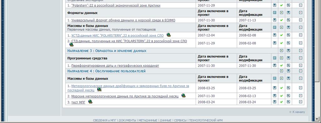
11 WEB potal IPY-Info - projects stewardship - metadata entry - loading of data files -monitoring of the data and metadata - search and access to the data and metadata - projects directory - expeditions inventory - inventory of historical data - metadata directory - data sets / distributed data base - documents

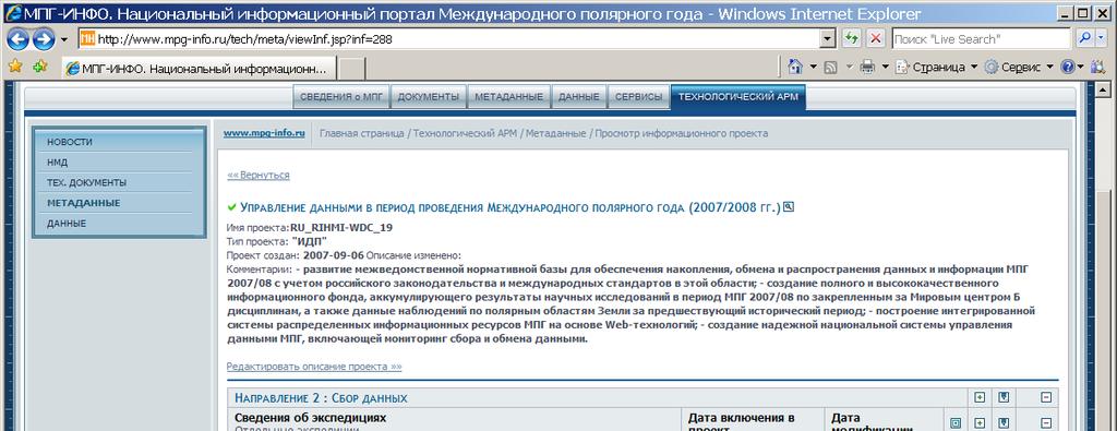
12 WEB forms for the project stewardship


13 WEB forms for the Data sets inventory


14 WEB forms for the Cruise Summary Report
![Access to the project data and metadata Depth [m];pres](/docs-images/88/116965716/images/15-1.jpg "[decibar];t [Cdegree];S;Nobs [u]; -0.540-0.534 0.5536 0.")


15 Access to the project data and metadata Depth [m];pres [decibar];t [Cdegree];S;Nobs [u];
![Access to the data via general directory Depth [m];pres [decibar];t](/docs-images/88/116965716/images/16-1.jpg "[Cdegree];S;Nobs; -0.540-0.534 0.5536 0.151234 1.4432-0.529-0.523 0.5814 0.164645 1.")


16 Access to the data via general directory Depth [m];pres [decibar];t [Cdegree];S;Nobs;


17 Overall scheme of E2E integration technology Portal and end-user user tools E2E Integration Server (RIHMI-WDC) E2E Data Providers (IPY disciplinary data centers)


18 E2E user interface

19 National and international DM coordination ICSU/WMO Joint Committee IPY-Info Data, metadata IPYDIS IPYDIS Metadata IPY disciplinary data centers Institutions, IPY-projects GCMD Directory IPY Metadata portal Data search Data search Users Data archives and networks Data
20 THANK YOU!
Growing Variety and Volume of Remote Sensing and In Situ Data
 The Potential Role of the World Data Centers in the Global Earth Observing System of Systems and the International Polar Year: CIESIN Experience to Date Dr. Robert S. Chen Director and Senior Research
The State of Arctic Data the IPY experience
 The State of Arctic Data the IPY experience Mark A. Parsons,Taco de Bruin, Scott Tomlinson, Øystein Godøy, Helen Campbell, Julie Leclert, Ellsworth LeDrew, David Carlson, and the IPY data community. 22
Data Portal and Integra.on in JAMSTEC
 Data Portal and Integra.on in JAMSTEC Yasunori Hanafusa Data Research Center for Marine-Earth Sciences (DrC) Agency for Marine-Earth Science and Technology (JAMSTEC) 1 Overview of Data Management in JAMSTEC
WDC ACTIVITIES IN JAPAN, 2008
 WDC ACTIVITIES IN JAPAN, 2008 Takashi Watanabe Solar-Terrestrial Environment Laboratory, Nagoya University Nagoya, Japan Email: c62d51ef58@yahoo.co.jp ABSTRACT This paper briefly reviews the activities
U.S. GEOTRACES PACIFIC TRANSECT DATA MANAGEMENT
 U.S. GEOTRACES PACIFIC TRANSECT DATA MANAGEMENT Cyndy Chandler BCO-DMO WHOI US GEOTRACES Pacific Zonal Transect Planning Workshop Woods Hole, MA USA 26 April 2013 1 of 31 TOPICS 1. What is BCO-DMO? 2.
SCICEX Data Stewardship: FY2012 Report
 DISTRIBUTION STATEMENT A. Approved for public release; distribution is unlimited. SCICEX Data Stewardship: FY2012 Report Florence Fetterer 449 UCB University of Colorado Boulder, CO 80309-0449 USA phone:
Sustaining Arctic Observing Networks (SAON)
") Sustaining Arctic Networks (SAON) Volker Rachold Arctic Science Commitee (IASC) and David Carlson Program Office (IPO) of the Polar Year (IPY) 2007/2008 Arctic Council Salekhard Declaration Urge all Member
Sustaining Arctic Networks (SAON) Volker Rachold Arctic Science Commitee (IASC) and David Carlson Program Office (IPO) of the Polar Year (IPY) 2007/2008 Arctic Council Salekhard Declaration Urge all Member
Introduction of SeaDataNet and EMODNET Working towards a harmonised data infrastructure for marine data. Peter Thijsse MARIS
 Introduction of SeaDataNet and EMODNET Working towards a harmonised data infrastructure for marine data Peter Thijsse MARIS CLIPC & IS-ENES 2 workshop, KNMI, November 2014 Outline 1. Introduction to marine
Rolling Deck to Repository: Opportunities for US-EU Collaboration
 Rolling Deck to Repository: Opportunities for US-EU Collaboration Stephen Miller Scripps Institution of Oceanography La Jolla, California USA http://gdc.ucsd.edu Co-authors: Helen Glaves British Geological
JCOMM Observing Programme Support Centre
 JCOMM Observing Programme Support Centre GO-SHIP International Planning Meeting Portland OR, Febr 21 2010 Yves Desaubies Mathieu Belbeoch Hester Viola Aims of this talk Presentation of JCOMMOPS Infrastructure
JAMSTEC Ocean Data Systems
 The 10th GEOSS Asia-Pacific Symposium Hanoi, Vietnam, 19 September 2017 JAMSTEC Ocean Data Systems Yasunori Hanafusa Data Management Office, Japan Agency for Marine-Earth Science and Technology (JAMSTEC)
Current JGOFS DMTT activities, and data management requirements for future marine biogeochemical projects - insights for modelers
 1 Current JGOFS DMTT activities, and data management requirements for future marine biogeochemical projects - insights for modelers Margarita Conkright Ocean Climate Laboratory National Oceanographic Data
Far Eastern segment of the Unified State System of Information on the World Ocean (ESIMO)
") Far Eastern segment of the Unified State System of Information on the World Ocean (ESIMO) Evgeny Vyazilov 1, Evgeny Uraevsky 2, Igor Rostov 3, Natalia Rudykh 3, Vladimir Rostov 3, Elena Dmitrieva 3 and
Far Eastern segment of the Unified State System of Information on the World Ocean (ESIMO) Evgeny Vyazilov 1, Evgeny Uraevsky 2, Igor Rostov 3, Natalia Rudykh 3, Vladimir Rostov 3, Elena Dmitrieva 3 and
M70/2 processing report
 FIELAX Gesellschaft für wissenschaftliche Datenverarbeitung mbh Phone: +49 (0) 471 30015 0, Fax: +49 (0) 471 30015 22, Mail: info@fielax.de, W3:www.fielax.de Schifferstraße 10-14, 27568 Bremerhaven M70/2
5PRESENTING AND DISSEMINATING
 5PRESENTING AND DISSEMINATING INFORMATION This chapter presents information and guidance on how to present and disseminate marine water quality monitoring data to the program s intended audience. Section
Developing the ICSU World Data System (WDS)
") Developing the ICSU World Data System (WDS) 2009-2010 Mustapha Mokrane ICSU Secretariat Science and Information Technology Officer ICSU s Vision (A world where) universal and equitable access to high quality
Developing the ICSU World Data System (WDS) 2009-2010 Mustapha Mokrane ICSU Secretariat Science and Information Technology Officer ICSU s Vision (A world where) universal and equitable access to high quality
INTAROS Integrated Arctic Observation System
 INTAROS Integrated Arctic Observation System A project funded by EC - H2020-BG-09-2016 Coordinator: Stein Sandven Nansen Environmental and Remote Sensing Center, Norway Overall objective: to develop an
Metadata for Data Discovery: The NERC Data Catalogue Service. Steve Donegan
 Metadata for Data Discovery: The NERC Data Catalogue Service Steve Donegan Introduction NERC, Science and Data Centres NERC Discovery Metadata The Data Catalogue Service NERC Data Services Case study:
The UK Marine Environmental Data and Information Network MEDIN
 The UK Marine Environmental Data and Information Network MEDIN M. Charlesworth, R. Lowry, H. Freeman, J. Rapaport, B Seeley Content MEDIN - a brief overview for context Discovery Metadata Standard and
Data Management Plan: OR Mooring - Ocean Acidification related measurements (Taken from NOAA Data Sharing Template and adapted for IOOS Certification)
") I. Type of data and information created 1. What data will you collect or create in the research? Contextual statement describing what data are collected and relevant URL (IOOS Certification, f 2) Hales
I. Type of data and information created 1. What data will you collect or create in the research? Contextual statement describing what data are collected and relevant URL (IOOS Certification, f 2) Hales
Introduction of new WDCGG website. Seiji MIYAUCHI Meteorological Agency
 Introduction of new WDCGG website Seiji MIYAUCHI WDCGG@Japan Meteorological Agency 1. Introduction of new WDCGG website 2. Starting to gather and provide satellite data at WDCGG Current WDCGG website 3
Overview. 2 Module 4: Data Conversion and Plotting
 2 Module 4: Data Conversion and Plotting Overview In this module we will cover the data processing basics, no fancy stuff. With this information you can go from raw data file to something you can print
Geospatial Access and Data Display Adds Value to Data Management at the Biological and Chemical Oceanographic Data Management Office
 Geospatial Access and Data Display Adds Value to Data Management at the Biological and Chemical Oceanographic Data Management Office M. Dickson Allison 1 and Charlton Galvarino 2 1 Woods Hole Oceanographic
Towards a Canadian Integrated Ocean Observing System
 Towards a Canadian Integrated Ocean Observing System CMOS Luncheon (Ottawa) February 28, 2018 Andrew Stewart Fisheries and Oceans Canada The Ocean is Valuable Ocean Economy: Ocean-based industries Natural
ITACS : Interactive Tool for Analysis of the Climate System
 Contents 1 2 3 4 ITACS : Interactive Tool for Analysis of the Climate System Features of the ITACS Atmospheric Analysis Data, Outgoing Longwave Radiation (by NOAA), SST, Ocean Analysis Data, etc. Plain
NEMO Reformating tool
 NEMO Reformating tool Michèle Fichaut- Ifremer NEMO [current version 1.6.3] Can be downloaded from SeaDataNet Web site https://www.seadatanet.org/software/nemo Written in Java Language (Version >= 1.7)
Technical documentation. SIOS Data Management Plan
 Technical documentation SIOS Data Management Plan SIOS Data Management Plan Page: 2/10 SIOS Data Management Plan Page: 3/10 Versions Version Date Comment Responsible 0.3 2017 04 19 Minor modifications
DANUBIUS-RI, the pan-european distributed research infrastructure supporting interdisciplinary research on river-sea systems
 DANUBIUS-RI, the pan-european distributed research infrastructure supporting interdisciplinary research on river-sea systems Dr. Adrian Stanica, DANUBIUS-RI ESFRI Project Coordinator www.danubius-ri.eu
DataONE: Open Persistent Access to Earth Observational Data
 Open Persistent Access to al Robert J. Sandusky, UIC University of Illinois at Chicago The Net Partners Update: ONE and the Conservancy December 14, 2009 Outline NSF s Net Program ONE Introduction Motivating
DEVELOPMENT OF THE WDS RUSSIAN-UKRAINIAN SEGMENT
 DEVELOPMENT OF THE WDS RUSSIAN-UKRAINIAN SEGMENT Marsel Shaimardanov 1*, Alexei Gvishiani 2, Michael Zgurovsky 3, Alexander Sterin 4, Alexander Kuznetsov 5, Natalia Sergeyeva 6, Evgeny Kharin 7, and Kostiantyn
NetCDF Metadata Guidelines for FY 2011 IOC NOAA Climate Data Records
 NetCDF Metadata Guidelines for FY 2011 IOC NOAA Climate Data Records This document provides guidance on a recommended set of netcdf metadata attributes to be implemented for the FY 2011 Initial Operating
Development of an information service system based on GOOGLE graphical interfaces. Instruction for the use of the MOON-VOS portal Interface
 Development of an information service system based on GOOGLE graphical interfaces Instruction for the use of the MOON-VOS portal Interface Giuseppe M.R. Manzella ENEA Operational Oceanography, p.o. box
Overview of a marine radioactivity database and data management
 Overview of a marine radioactivity database and data management Paul Morris Department of Nuclear Sciences and Applications Environment Laboratories, Monaco MARiS Marine Information System This presentation
OCEAN DATA MANAGEMENT IN MALAYSIA. The 10th GEOSS Asia-Pacific Symposium Hanoi, Vietnam, September 2017
 OCEAN DATA MANAGEMENT IN MALAYSIA The 10th GEOSS Asia-Pacific Symposium Hanoi, Vietnam, 18 20 September 2017 Presentation Overview Malaysian Oceanographic Data Aggregation & Archiving System (MyDAS) Ocean
International Oceanographic Data and Information Exchange - Ocean Data Portal (IODE ODP)
") International Oceanographic Data and Information Exchange - Ocean Data Portal (IODE ODP) Enabling science through seamless and open access to marine data Credits This presentation was developed by: Mr.
International Oceanographic Data and Information Exchange - Ocean Data Portal (IODE ODP) Enabling science through seamless and open access to marine data Credits This presentation was developed by: Mr.
The IODE Ocean Data Portal: Concept Paper (by Greg Reed, Nick Michailov, Peter Pissierssens)
") Limited distribution IOC/IODE-XIX/15 22 February 2007 Original: English INTERGOVERNMENTAL OCEANOGRAPHIC COMMISSION (of UNESCO) Nineteenth Session of the IOC Committee on International Oceanographic Data
Limited distribution IOC/IODE-XIX/15 22 February 2007 Original: English INTERGOVERNMENTAL OCEANOGRAPHIC COMMISSION (of UNESCO) Nineteenth Session of the IOC Committee on International Oceanographic Data
NATIONAL OCEANIC AND ATMOSPHERIC ADMINISTRATION S SCIENTIFIC DATA STEWARDSHIP PROGRAM
 J2.3A NATIONAL OCEANIC AND ATMOSPHERIC ADMINISTRATION S SCIENTIFIC DATA STEWARDSHIP PROGRAM John J. Bates * NOAA National Climatic Center, Asheville, North Carolina Richard G. Reynolds Office of Systems
East Pacific Investigation of Climate Processes in the Coupled Ocean-Atmosphere System (EPIC-2001) Data Management Plan
 Data Management Plan") East Pacific Investigation of Climate Processes in the Coupled Ocean-Atmosphere System (EPIC-2001) Data Management Plan DRAFT VERSION 1.0 July 2001 Compiled by: University Corporation for Atmospheric Research
East Pacific Investigation of Climate Processes in the Coupled Ocean-Atmosphere System (EPIC-2001) Data Management Plan DRAFT VERSION 1.0 July 2001 Compiled by: University Corporation for Atmospheric Research
Interactive comment on Data compilation on the biological response to ocean acidification: an update by Y. Yang et al.
 Earth Syst. Sci. Data Discuss., 8, C469 C477, 2016 www.earth-syst-sci-data-discuss.net/8/c469/2016/ Author(s) 2016. This work is distributed under the Creative Commons Attribute 3.0 License. Open Access
3. BACKGROUND North Pacific Ecosystem Metadatabase
 3. BACKGROUND The foundation of the PICES Metadata Federation effort was the creation and development of the North Pacific Ecosystem Metadatabase (NPEM, originally called the Bering Sea Ecosystem Biophysical
Judith Connor Monterey Bay Aquarium Research Institute
 ARCHIVING, ANNOTATING AND ACCESSING VIDEO AS DATA Judith Connor Monterey Bay Aquarium Research Institute E-mail: conn@mbari.org ABSTRACT: Since 1989, the Monterey Bay Aquarium Research Institute (MBARI)
Introduction to Data Management for Ocean Science Research
 Introduction to Data Management for Ocean Science Research Cyndy Chandler Biological and Chemical Oceanography Data Management Office 12 November 2009 Ocean Acidification Short Course Woods Hole, MA USA
NIAES station agro-meteorological data in Hokuriku, Japan
 NIAES station agrometeorological data in Hokuriku, Japan 1. IDENTIFICATION INFORMATION Metadata Identifier NIAES station agro-meteorological data in Hokuriku, Japan JP_NIAES_MetData_MeteoCrop_AMeDAS_Hokuriku20181216210001-DIAS20180903143952-
Metadata or "data about data" describe the content, quality, condition, and other characteristics of data. The Federal Geographic Data Committee
 Metadata or "data about data" describe the content, quality, condition, and other characteristics of data. The Federal Geographic Data Committee (http://www.fgdc.gov/) approved the Content Standard for
Toward the Development of a Comprehensive Data & Information Management System for THORPEX
 Toward the Development of a Comprehensive Data & Information Management System for THORPEX Mohan Ramamurthy, Unidata Steve Williams, JOSS Jose Meitin, JOSS Karyn Sawyer, JOSS UCAR Office of Programs Boulder,
The IRIS Data Management Center maintains the world s largest system for collecting, archiving and distributing freely available seismological data.
 The IRIS Data Management Center maintains the world s largest system for collecting, archiving and distributing freely available seismological data. DATA Data are open and freely available via the internet
Data Curation Practices at the Oak Ridge National Laboratory Distributed Active Archive Center
 Data Curation Practices at the Oak Ridge National Laboratory Distributed Active Archive Center Robert Cook, DAAC Scientist Environmental Sciences Division Oak Ridge National Laboratory Oak Ridge, TN cookrb@ornl.gov
Master Track RV Polarstern ANT-IV/2
 Master Track RV Polarstern ANT-IV/2 Data Processing Report Contents 1 Introduction 1 2 Workflow 1 3 Cruise details 2 4 Sensor Layout 2 5 Processing Report 3 Contact: Dr. Rainer Knust Alfred Wegener Institute
Global Data Activities for the Study of Solar-Terrestrial Variability
 Joint WDS SCOSTEP/VarSITI Workshop Global Data Activities for the Study of Solar-Terrestrial Variability Date: 3 days in September 2015 (TBD) Place: Tokyo, Japan (TBD) The principal objective of the joint
Towards a Portal to Atmospheric and Marine Information Resources (PAMIR)
") Towards a Portal to Atmospheric and Marine Information Resources (PAMIR) Anne De Rudder, Jean-Christopher Lambert Belgian Institute for Space Aeronomy (IASB-BIRA) Serge Scory, Myriam Nemry Royal Belgian
Towards a Portal to Atmospheric and Marine Information Resources (PAMIR) Anne De Rudder, Jean-Christopher Lambert Belgian Institute for Space Aeronomy (IASB-BIRA) Serge Scory, Myriam Nemry Royal Belgian
EUDAT-B2FIND A FAIR and Interdisciplinary Discovery Portal for Research Data
 EUDAT-B2FIND A FAIR and Interdisciplinary Discovery Portal for Research Data Heinrich Widmann, DKRZ Claudia Martens, DKRZ Open Science Days, Berlin, 17 October 2017 www.eudat.eu EUDAT receives funding
WP4: Data Forum. Øystein Godøy, Boris Radosavljević, Boris Biskaborn, Anna Irrgang
 WP4: Data Forum Øystein Godøy, Boris Radosavljević, Boris Biskaborn, Anna Irrgang Motivation INTERACT research stations generate data and metadata Long term monitoring Short term process studies External
Enabling Collaboration for Digital Preservation
 Enabling Collaboration for Digital Preservation ipres 2009, San Francisco Martha Anderson The Library of Congress .trust and reciprocity lengthen the shadow of the future. Axelrod,The Evolution of Cooperation,1984.
SeaDataNet, Pan-European infrastructure for marine ands ocean data management + EMODNET Preparatory Action Hydrographic and Seabed Mapping
 SeaDataNet, Pan-European infrastructure for marine ands ocean data management + EMODNET Preparatory Action Hydrographic and Seabed Mapping By Dick M.A. Schaap Technical Coordinator SeaDataNet & Coordinator
Data and information sharing WMO global systems
 Data and information sharing WMO global systems Tommaso Abrate Scientific Officer World Meteorological Organization E-mail: tabrate@wmo.int 13 March, 2012 World Hydrological Cycle Observing System (WHYCOS)
The Canadian High Arctic Research Station Forum of Arctic Research Operators Annual Meeting, April 2012 Montréal, Québec
 The Canadian High Arctic Research Station Forum of Arctic Research Operators Annual Meeting, April 2012 Montréal, Québec Version: April 20, 2012 2:30 p.m. Canada s Northern Strategy Sovereignty Social
Defense Coastal/Estuarine Research Program (DCERP) SERDP RC DCERP Data Policy Version 2.0
 SERDP RC DCERP Data Policy Version 2.0") Defense Coastal/Estuarine Research Program (DCERP) SERDP RC-2245 DCERP Data Policy Version 2.0 November 13, 2009 (Version 1) February 2016 (Version 2) Prepared by: RTI International * 3040 Cornwallis Road
Defense Coastal/Estuarine Research Program (DCERP) SERDP RC-2245 DCERP Data Policy Version 2.0 November 13, 2009 (Version 1) February 2016 (Version 2) Prepared by: RTI International * 3040 Cornwallis Road
Projections for use in the Merced River basin
 Instructions to download Downscaled CMIP3 and CMIP5 Climate and Hydrology Projections for use in the Merced River basin Go to the Downscaled CMIP3 and CMIP5 Climate and Hydrology Projections website. 1.
IMPLEMENTATON OF SOUTHASIA CLIMATE ASSESSMET AND DASET (SACA&D) AT BMKG
 AT BMKG") IMPLEMENTATON OF SOUTHASIA CLIMATE ASSESSMET AND DASET (SACA&D) AT BMKG OUTLINE Introduction of SACAD System Preparation of Implementation Data collecting and reformatting Preparing HW,SW and BW Current
IMPLEMENTATON OF SOUTHASIA CLIMATE ASSESSMET AND DASET (SACA&D) AT BMKG OUTLINE Introduction of SACAD System Preparation of Implementation Data collecting and reformatting Preparing HW,SW and BW Current
Data discovery and access via the SeaDataNet CDI system
 Data discovery and access via the SeaDataNet CDI system Central dataproducts and data services on distributed data. Peter Thijsse MARIS CLIPC IS-ENES workshop, KNMI, November 2014 Outline 1. Introduction
Interpolation. Computer User Training Course Paul Dando. User Support. ECMWF 25 February 2016
 Interpolation Computer User Training Course 2016 Paul Dando User Support advisory@ecmwf.int ECMWF 25 February 2016 1 Contents Introduction Overview of Interpolation Spectral Transformations Grid point
Global Cryosphere Watch. GCW web portal Structure and demonstration
 Global Cryosphere Watch GCW web portal Structure and demonstration Øystein Godøy The high level purpose The GCW web portal will make GCW data and information available to WMO Members, their partners, and
Technical English -I 5 th week SURVEYING AND MAPPING
 Technical English -I 5 th week SURVEYING AND MAPPING What is surveying? It is the art of defining the positions of natural and man-made made features on the Earth s surface. Basic Tasks and Features in
Data Management Plan: Port Radar, Oregon State University (Taken from NOAA Data Sharing Template and adapted for IOOS Certification)
") 1 Data Management Plan: Port Radar, Oregon State University I. Type of data and information created 1. What data will you collect or create in the research? Contextual statement describing what data are
1 Data Management Plan: Port Radar, Oregon State University I. Type of data and information created 1. What data will you collect or create in the research? Contextual statement describing what data are
Interoperability ~ An Introduction
 Interoperability ~ An Introduction Cyndy Chandler Biological and Chemical Oceanography Data Management Office (BCO-DMO) Woods Hole Oceanographic Institution 26 July 2008 MMI OOS Interoperability Planning
The IOC Project Office for IODE
 The IOC Project Office for IODE What activities do we undertake to achieve our objectives? Hosting of specialized short-term training courses and workshops in ocean data and information management, marine
HORIZON 2020 EU ARCTIC RESEARCH Information Session. Presentation By Cecilia S. Silundika, NCP Arctic Montreal and Quebec City, March 26-27, 2015
 HORIZON 2020 EU ARCTIC RESEARCH Information Session Presentation By Cecilia S. Silundika, NCP Arctic Montreal and Quebec City, March 26-27, 2015 EU-Canada Arctic Working Group: Overview The European Union-Canada
Technical specifications for accessing Water Level Web Services
 Technical specifications for accessing Water Level Web Services Version 2.0.3 September 2014 Canadian Hydrographic Service Fisheries and Oceans Canada Contents Introduction... 3 Access and support... 3
Collaborations and Partnerships. John Broome CODATA-International
 Collaborations and Partnerships John Broome CODATA-International 1 CODATA-International One of the fundamental roles of CODATA is to facilitate collaboration and partnerships in the management of research
How to check the location, status and usage of AnyNet Secure SIMs on AWS IoT
 How to check the location, status and usage of AnyNet Secure SIMs on AWS IoT The Eseye AWS IoT integration enables look-up of SIM card usage and location by pushing device updates to your AWS IoT Cloud.
An Overview of International Data Coordination Activities
 An Overview of International Data Coordination Activities Peter L. Pulsifer Chair, IASC-SAON Arctic Data Committee Research Scientist, National Snow and Ice Data Center, University of Colorado ASSW/AOS
- C3Grid Stephan Kindermann, DKRZ. Martina Stockhause, MPI-M C3-Team
 A Collaborative Environment for Climate Data Handling - Stephan Kindermann, DKRZ Martina Stockhause, MPI-M C3-Team 10.06. 2008 Motivation Model Output Data + Observation Data + TeraByte Analysis Data Expected
ALASKA OCEAN OBSERVING SYSTEM DATA ASSEMBLY CENTER AND DATA MANAGEMENT SUBSYSTEM PLAN EFFECTIVE: JUNE 1, 2016 MAY 31, 2021
 ALASKA OCEAN OBSERVING SYSTEM DATA ASSEMBLY CENTER AND DATA MANAGEMENT SUBSYSTEM PLAN EFFECTIVE: JUNE 1, 2016 MAY 31, 2021 1.0 INTRODUCTION The Alaska Ocean Observing System (AOOS) was established in 2004
Draft version 13 th July Delivery manual for Article 12 data
 Delivery manual for Article 12 data Draft version 13 th July 2018 Contents 1 Introduction... 3 2 Data preparation process... 3 2.1 Overview... 3 2.2 Data validation... 4 2.3 Tabular data standards for
The PICES Metadata Federation: Pacific-wide marine metadata discovery, management and delivery for FUTURE
 PICES 17th Annual Meeting Dalian, People s Republic of China October 30, 2008 The PICES Metadata Federation: Pacific-wide marine metadata discovery, management and delivery for FUTURE S. Allen Macklin
NASA's GLOBAL CHANGE MASTER DIRECTORY: FOSTERING COLLABORATIONS FOR EARTH SCIENCE INFORMATION AND DATA RETRIEVAL
 NASA's GLOBAL CHANGE MASTER DIRECTORY: FOSTERING COLLABORATIONS FOR EARTH SCIENCE INFORMATION AND DATA RETRIEVAL Gene R Major NASA Global Change Master Directory Raytheon ITSS 4500 Forbes Blvd. Suite 300
Project Baseline. Documentation Only Projects 2016
 Project Baseline Documentation Only Projects 2016 Introduction Thanks for your interest in joining this grassroots, aquatic conservation initiative supported by Global Underwater Explorers! By contributing
JCOMMOPS JCOMM Observing Program Support Centre
 JCOMMOPS JCOMM Observing Program Support Centre Etienne Charpentier (WMO) Mathieu Belbeoch (JCOMMOPS) MARCDAT III, Frascati, 2 6May 2011 Observational programme implementation JCOMMOPS was established
Wade Sheldon. Georgia Coastal Ecosystems LTER University of Georgia CUAHSI Virtual Workshop Field Data Management Solutions
 Wade Sheldon Georgia Coastal Ecosystems LTER University of Georgia email: sheldon@uga.edu CUAHSI Virtual Workshop Field Data Management Solutions 01-Oct-2014 Georgia Coastal Ecosystems LTER started in
What is ODV? Latest version: ver (updated Jan 9, 2017) Currently >50,000 users, ~20 new users every day!!
 Currently >50,000 users, ~20 new users every day!!") OCN 623 How to use ODV Latest version: ver. 4.7.9 (updated Jan 9, 2017) http://odv.awi.de/ Currently >50,000 users, ~20 new users every day!! Feb 2, 2017 What is ODV? Ocean Data View (ODV) is a software
OCN 623 How to use ODV Latest version: ver. 4.7.9 (updated Jan 9, 2017) http://odv.awi.de/ Currently >50,000 users, ~20 new users every day!! Feb 2, 2017 What is ODV? Ocean Data View (ODV) is a software
(Towards) A metadata model for atmospheric data resources
 A metadata model for atmospheric data resources") (Towards) A metadata model for atmospheric data resources Anne De Rudder and Jean-Christopher Lambert Belgian Institute for Space Aeronomy (IASB-BIRA), Brussels The context EU FP7 Ground-based atmospheric
(Towards) A metadata model for atmospheric data resources Anne De Rudder and Jean-Christopher Lambert Belgian Institute for Space Aeronomy (IASB-BIRA), Brussels The context EU FP7 Ground-based atmospheric
A Data Management Plan Template for Ecological Restoration and Monitoring
 A Data Management Plan Template for Ecological Restoration and Monitoring Brick M. Fevold Research Scientist Advisor, GDIT Judy Schofield 1, Rob Sutter 1, Craig Palmer 1, Elizabeth Benjamin 1, Molly M.
DIAS_Satellite_MODIS_SurfaceReflectance dataset
 DIAS_Satellite_MODIS_SurfaceReflectance dataset 1. IDENTIFICATION INFORMATION DOI Metadata Identifier DIAS_Satellite_MODIS_SurfaceReflectance dataset doi:10.20783/dias.273 [http://doi.org/10.20783/dias.273]
Data Management Plan: NANOOS Washington Coast Moorings, Northwest Environmental Moorings Lab, University of Washington
 I. Type of data and information created 1. What data will you collect or create in the research? Contextual statement describing what data are collected and relevant URL (IOOS Certification, f 2) Since
Data Stewardship NOAA s Programs for Archive, Access, and Producing Climate Data Records
 Data Stewardship NOAA s Programs for Archive, Access, and Producing Climate Data Records John Bates, NOAA s National Climatic Data Center Mitch Goldberg, NOAA s Office of Research and Applications 1 Background
Using a Geographic Information System (GIS) to look at marine fisheries data
 to look at marine fisheries data") Using a Geographic Information System (GIS) to look at marine fisheries data Daniel Sheehan GIS Programmer & Analyst Office of Educational Innovation & Technology dsheehan@mit.edu x2-1475 Introduction
Using a Geographic Information System (GIS) to look at marine fisheries data Daniel Sheehan GIS Programmer & Analyst Office of Educational Innovation & Technology dsheehan@mit.edu x2-1475 Introduction
RECCA Nagoya RECCA_MAPS_Nagoya DIAS en
 RECCA Nagoya 2050 1. IDENTIFICATION INFORMATION RECCA Nagoya 2050 Edition v0.1 Abbreviation Metadata Identifier 2. CONTACT RECCA_MAP_DIF 2.1 CONTACT on DATASET RECCA_MAPS_Nagoya20181216214915-DIAS20180903143952-en
DATA INTEGRATION AT THE NATIONAL LEVEL
 DATA INTEGRATION AT THE NATIONAL LEVEL SERGEY EGORENKO DEPUTY HEAD, FEDERAL STATE STATISTICS SERVICE (ROSSTAT) 11-13 DECEMBER 2017 BANGKOK, THAILAND CENTRALIZED SYSTEM OF THE STATE STATISTICS WITH ELEMENTS
Report from the SMHI monitoring cruise with R/V Aranda
 Martin Hansson Swedish Meteorological and Hydrological Institute Oceanographic Laboratory 1-1-1 Dnr: S/Gbg-1-13 Report from the SMHI monitoring cruise with R/V Aranda Survey period: 1-1-1 to 1-1-1 Principal:
Ship Energy Systems Modelling: a Gray-Box approach
 MOSES Workshop: Modelling and Optimization of Ship Energy Systems Ship Energy Systems Modelling: a Gray-Box approach 25 October 2017 Dr Andrea Coraddu andrea.coraddu@strath.ac.uk 30/10/2017 Modelling &
CoopEUS User Scenario: Tsunami Modelling and Early Warning Systems for Near Source Areas (Mediterranean, Juan de Fuca).
.") CoopEUS User Scenario: Tsunami Modelling and Early Warning Systems for Near Source Areas (Mediterranean, Juan de Fuca). Contributors EMSO Laura Beranzoli, Mairi Best, Francesco Chierici, Davide Embriaco,
CoopEUS User Scenario: Tsunami Modelling and Early Warning Systems for Near Source Areas (Mediterranean, Juan de Fuca). Contributors EMSO Laura Beranzoli, Mairi Best, Francesco Chierici, Davide Embriaco,
Is my institution ready for data citation? Dave Connell, Australian Antarctic Data Centre
 Is my institution ready for data citation? Dave Connell, Australian Antarctic Data Centre Am I ready? Q: How do you know if an organisation is ready for Data Citation? The Australian Antarctic Division
55033: SHAREPOINT 2013 SITE COLLECTION AND SITE ADMINISTRATION
 ABOUT THIS COURSE This five-day instructor-led course is intended for power users, who are tasked with working within the SharePoint 2013 environment. This course will provide a deeper, narrowly-focused
SharePoint 2013 Site Collection and Site Administration
 SharePoint 2013 Site Collection and Site Administration Course 55033; 5 Days, Instructor-led Course Description This five-day instructor-led course is intended for power users, who are tasked with working
Cyberinfrastructure Framework for 21st Century Science & Engineering (CIF21)
") Cyberinfrastructure Framework for 21st Century Science & Engineering (CIF21) NSF-wide Cyberinfrastructure Vision People, Sustainability, Innovation, Integration Alan Blatecky Director OCI 1 1 Framing the
Cyberinfrastructure Framework for 21st Century Science & Engineering (CIF21) NSF-wide Cyberinfrastructure Vision People, Sustainability, Innovation, Integration Alan Blatecky Director OCI 1 1 Framing the
RESOLUTION MSC.210(81) (adopted on 19 May 2006) PERFORMANCE STANDARDS AND FUNCTIONAL REQUIREMENTS FOR THE LONG-RANGE IDENTIFICATION AND TRACKING OF
 (adopted on 19 May 2006) PERFORMANCE STANDARDS AND FUNCTIONAL REQUIREMENTS FOR THE LONG-RANGE IDENTIFICATION AND TRACKING OF") MSC 81/25/Add.1 RESOLUTION MSC.210(81) REQUIREMENTS FOR THE LONG-RANGE IDENTIFICATION THE MARITIME SAFETY COMMITTEE, RECALLING Article 28(b) of the Convention on the International Maritime Organization
MSC 81/25/Add.1 RESOLUTION MSC.210(81) REQUIREMENTS FOR THE LONG-RANGE IDENTIFICATION THE MARITIME SAFETY COMMITTEE, RECALLING Article 28(b) of the Convention on the International Maritime Organization
Automated Data Quality Assurance for Marine Observations
 Automated Data Quality Assurance for Marine Observations James V. Koziana Science Applications International Corporation (SAIC) Hampton, VA 23666 USA Third Meeting of GCOOS DMAC Renaissance Orlando Hotel
Data Management Plans Are they working for the Australian Antarctic program? Dave Connell Australian Antarctic Data Centre
 Data Management Plans Are They Working for the Australian Antarctic Program? Dave Connell Data Management Plans Are they working for the Australian Antarctic program? Dave Connell Australian Antarctic
Arctic Action Overview
 Selected Topics International Arctic Council National Arctic Action Overview Interagency Working Group on Alaska Energy and Permitting Issues [E.O. 13580] Report to the President (March 2013) National