Data Portal and Integra.on in JAMSTEC
|
|
|
- Aileen Brooks
- 6 years ago
- Views:
Transcription
1 Data Portal and Integra.on in JAMSTEC Yasunori Hanafusa Data Research Center for Marine-Earth Sciences (DrC) Agency for Marine-Earth Science and Technology (JAMSTEC) 1
2 Overview of Data Management in JAMSTEC Integra.on in Data Publica.on Development of Data Portal Further extent to One- Stop Data Shop Integra.on of Mul.- Disciplinary Data Conversion of Data to Scio- Economic Informa.on 2
3 1. Overview of Data Management in JAMSTEC 3


4 history Started research cruises since Started data management since Established Data Policy since now Operates 8 research vessels and several submersibles. Conducts 100 cruises and 250 dives a year and moorings / terrestrial observa.ons. 4

5 Cruise Tracks of JAMSTEC s Research Vessels since
6 Amount of Data of Data Types Disseminated Data Type Cruise Observa.on Data Samples Deep Sea Images Terrestrial Observa.ons (Metadata) Moorings / Fixed Sta.ons (Metadata) Number of Data (units) 27,000 (observa.ons) 47,000 (samples) 15,500(tapes) 714,000(shots) 300(points) 200(points) Remarks Temperature, Salinity, Nutrients, Currents, Bathymetry, Gravity, Ocean Meteorology, etc. Rocks, Sediment Cores, Biological Samples Videos and S.ll Images by Submersibles Meteorology or Atmospheric Composi.on Observatories, Biological Survey Points TRITON, JKEO, K2, OBS, etc. 6


7 Research Cruise Data Video & Image Database and many Data Sites from Research Biological Projects Sample Database Cruise Reports Database Sediment Biodiversity Core Data Site Database Data Publication Sites in JAMSTEC 7
8 2. Integra.on in Data Publica.on Independent Data Sites to Data Portal Data Portal to One- Stop Data Shop 8
9 Why Data Portals? Large amount of data from wide range of research fields and geographical area Many kinds of data publica.on sites Data Discovery Services were necessary. Data Search Portal for observa.onal data Data Catalog for data publica.on sites Designed to complement each other 9

10 5th GEOSS Asia Pacific Symposium, Tokyo, 10
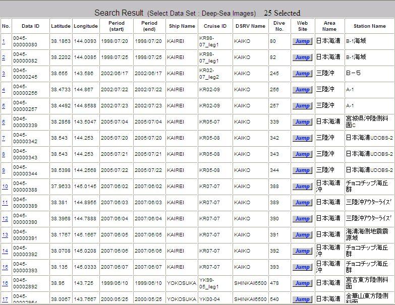
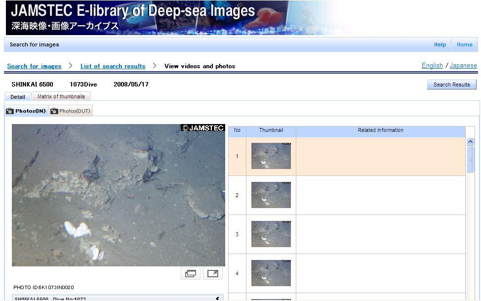
11 Data Search Portal Metadata of observa.ons Posi.on, Date/Period, Cruise ID, Data Type, Variables URL Link to the data dissemina.on page of the corresponding data can collaborate with any data system, which has the relevant URL for the specific data. 35,000 observa.ons and increasing 11

12 12

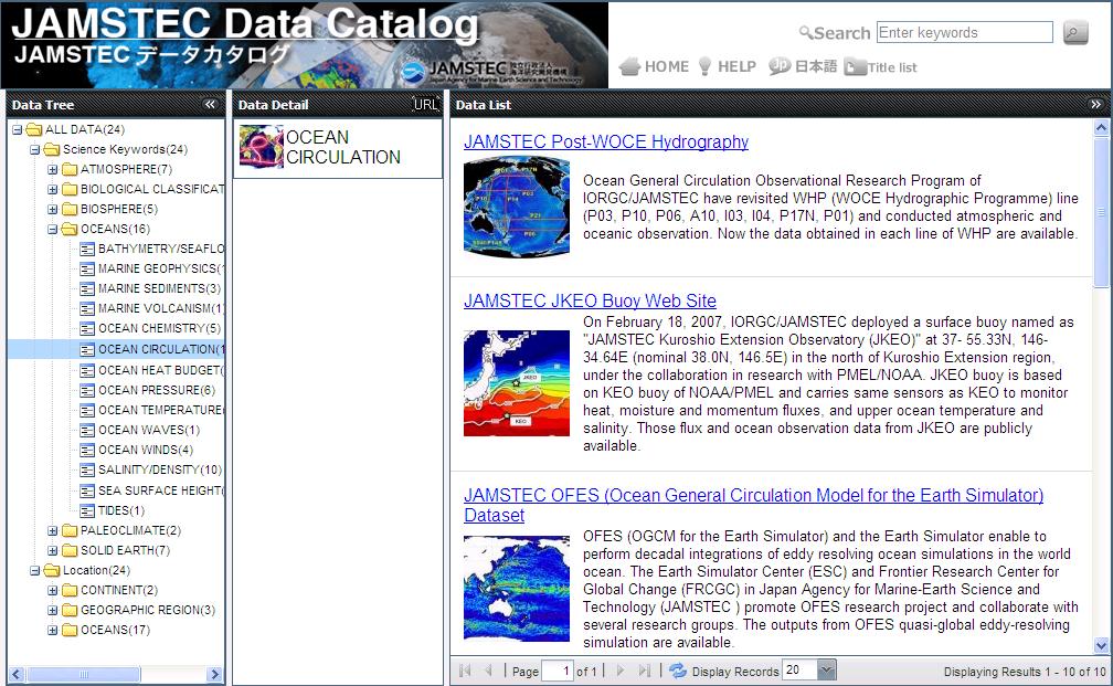
13 Data Catalog Metadata of databases Title, Summary, Cita.on, Data Center, Status Science Keywords Search by classifica.on trees of keywords ; Scien.fic fields or variables Geographical area Metadata Standard : Directory Interchange Format (DIF) in GCMD and ese version 13
14 2. Integra.on in Data Publica.on Independent Data Sites to Data Portal Data Portal to One- Stop Data Shop(future goal) 14
15 Data Portal Data Sites Search Download Data Access using Data Portal Data Sites One-Stop Data Shop Search Download Complex Search Visualization Extraction Format Conversion Download Basket On Demand Data Access Data Access in One-Stop Data Shop 15
16 One-Stop Data Shop Provides higher level of data handling Search by complex criteria Browse data before download Extract data in the area/period of interest Convert data to favorite format Keep datasets in a basket and download Challenges One- Stop Data Shop must communicate with data sites automa.cally 16

17 3. Integra.on of Mul.- Disciplinary Data Observa.on Data to Scio- Economic Informa.on example : Study for forecast of abundance of neon flying squid using data assimila.on model 17
18 Observational Data Data Assimilation Model SST SSH MLD Environmental Variables Compare EVs and CPUE SI SI SI SI SI Estimate Suitability Indices Estimation of fish abundance HSI Habitat Suitability Index HSI=f(Si1, Si2, Si3, ) SI: Suitability index SI=1.0 SST SSH SSH CPUE SI= Anti-cyclonic Eddy Moderate Current Speed Environmental Variables 18

19 Calcula.on of HSI from output of 3D data assimila.on model Compared with the actual fishing point records Shows possibility of efficient fishing. HSI 1 month later white dots: fishing points by commercial vessels 19
20 Summary Integra.on of data publica.on sites Data portals (Data Search Portal and Data Catalog) are in service now Going to develop the Integrated data handling system : One- Stop Data Shop Integra.on of observa.on data into social beneficial Informa.on Data assimila.on method is applied to make informa.on for fishing DrC/JAMSTEC has both func.ons. 20
21 Thank you for your attention. 21
JAMSTEC Ocean Data Systems
 The 10th GEOSS Asia-Pacific Symposium Hanoi, Vietnam, 19 September 2017 JAMSTEC Ocean Data Systems Yasunori Hanafusa Data Management Office, Japan Agency for Marine-Earth Science and Technology (JAMSTEC)
Global couplled ocean-atmosphere reanalysis and forecast with pelagic ecosystem
 Global couplled oceanatmosphere reanalysis and forecast with pelagic ecosystem 1. IDENTIFICATION INFORMATION Abbreviation Metadata Identifier Global couplled ocean-atmosphere reanalysis and forecast with
Data and information sharing WMO global systems
 Data and information sharing WMO global systems Tommaso Abrate Scientific Officer World Meteorological Organization E-mail: tabrate@wmo.int 13 March, 2012 World Hydrological Cycle Observing System (WHYCOS)
INTAROS Integrated Arctic Observation System
 INTAROS Integrated Arctic Observation System A project funded by EC - H2020-BG-09-2016 Coordinator: Stein Sandven Nansen Environmental and Remote Sensing Center, Norway Overall objective: to develop an
Introduction of SeaDataNet and EMODNET Working towards a harmonised data infrastructure for marine data. Peter Thijsse MARIS
 Introduction of SeaDataNet and EMODNET Working towards a harmonised data infrastructure for marine data Peter Thijsse MARIS CLIPC & IS-ENES 2 workshop, KNMI, November 2014 Outline 1. Introduction to marine
MANAGEMENT OF IPY 2007/08 NATIONAL DATA
 SAON MANAGEMENT OF IPY 2007/08 NATIONAL DATA M.Shaimardanov, A.Sterin, Nickolay Mikhailov, Alexander Kuznetsov, Eugeny Vyazilov R I H M I W D C The scientific programme for participation of Russian Federation
INSPIRE Conference 2018 (18 21 September, Antwerp)
") INSPIRE Conference 2018 (18 21 September, Antwerp) Introduction The Marine Strategy Framework Directive (MSFD) of the European Commission defines some obligations for the implementation of strategies for
INSPIRE Conference 2018 (18 21 September, Antwerp) Introduction The Marine Strategy Framework Directive (MSFD) of the European Commission defines some obligations for the implementation of strategies for
OCEAN DATA MANAGEMENT IN MALAYSIA. The 10th GEOSS Asia-Pacific Symposium Hanoi, Vietnam, September 2017
 OCEAN DATA MANAGEMENT IN MALAYSIA The 10th GEOSS Asia-Pacific Symposium Hanoi, Vietnam, 18 20 September 2017 Presentation Overview Malaysian Oceanographic Data Aggregation & Archiving System (MyDAS) Ocean
Metadata for Data Discovery: The NERC Data Catalogue Service. Steve Donegan
 Metadata for Data Discovery: The NERC Data Catalogue Service Steve Donegan Introduction NERC, Science and Data Centres NERC Discovery Metadata The Data Catalogue Service NERC Data Services Case study:
Metadata Zoo Dataset Metadata Rebecca Koskela Execu4ve Director, DataONE
 Metadata Zoo Dataset Metadata Rebecca Koskela Execu4ve Director, DataONE eurocris September 9, 2013 Outline Data Challenges Metadata Solu=on DataONE addressing the Data Challenge Enabling Scien=fic Discovery
Towards a Canadian Integrated Ocean Observing System
 Towards a Canadian Integrated Ocean Observing System CMOS Luncheon (Ottawa) February 28, 2018 Andrew Stewart Fisheries and Oceans Canada The Ocean is Valuable Ocean Economy: Ocean-based industries Natural
Automated Data Quality Assurance for Marine Observations
 Automated Data Quality Assurance for Marine Observations James V. Koziana Science Applications International Corporation (SAIC) Hampton, VA 23666 USA Third Meeting of GCOOS DMAC Renaissance Orlando Hotel
SEXTANT 1. Purpose of the Application
 SEXTANT 1. Purpose of the Application Sextant has been used in the domains of Earth Observation and Environment by presenting its browsing and visualization capabilities using a number of link geospatial
DANUBIUS-RI, the pan-european distributed research infrastructure supporting interdisciplinary research on river-sea systems
 DANUBIUS-RI, the pan-european distributed research infrastructure supporting interdisciplinary research on river-sea systems Dr. Adrian Stanica, DANUBIUS-RI ESFRI Project Coordinator www.danubius-ri.eu
INSPIRE & Environment Data in the EU
 INSPIRE & Environment Data in the EU Andrea Perego Research Data infrastructures for Environmental related Societal Challenges Workshop @ pre-rda P6 Workshops, Paris 22 September 2015 INSPIRE in a nutshell
European Marine Data Exchange
 European Marine Data Exchange By Dick M.A. Schaap MARIS (NL) EU SeaDataNet Technical Coordinator EU EMODnet Ingestion Coordinator Noordzeedagen 2018 - October 2018 Acquisition of ocean and marine data
DataONE Cyberinfrastructure. Ma# Jones Dave Vieglais Bruce Wilson
 DataONE Cyberinfrastructure Ma# Jones Dave Vieglais Bruce Wilson Foremost a Federa9on Member Nodes (MNs) Heart of the federa9on Harness the power of local cura9on Coordina9ng Nodes (CNs) Services to link
Data discovery and access via the SeaDataNet CDI system
 Data discovery and access via the SeaDataNet CDI system Central dataproducts and data services on distributed data. Peter Thijsse MARIS CLIPC IS-ENES workshop, KNMI, November 2014 Outline 1. Introduction
WDC ACTIVITIES IN JAPAN, 2008
 WDC ACTIVITIES IN JAPAN, 2008 Takashi Watanabe Solar-Terrestrial Environment Laboratory, Nagoya University Nagoya, Japan Email: c62d51ef58@yahoo.co.jp ABSTRACT This paper briefly reviews the activities
CASE STUDY. Case Study: Thuraya Orion IP. Products: Thuraya Orion IP Thuraya SF2500. Location: Caspian Sea, Kazakhstan
 Case Study: Thuraya Orion IP Products: Thuraya Orion IP Thuraya SF2500 Location: Caspian Sea, Kazakhstan Thuraya is helping to protect the unique and fragile ecosystem of the largest salt lake on Earth
The Alaska Marine Information System
 The Alaska Marine Information System Dr. Mark Johnson Professor of Marine Science Institute of Marine Science University of Alaska Fairbanks Google Alaska Ocean Observing System or AOOS See Access the
DART Tutorial Sec'on 21: Observa'on Types and Observing System Design
 DART Tutorial Sec'on 21: Observa'on Types and Observing System Design UCAR 2014 The Na'onal Center for Atmospheric Research is sponsored by the Na'onal Science Founda'on. Any opinions, findings and conclusions
The PICES Metadata Federation: Pacific-wide marine metadata discovery, management and delivery for FUTURE
 PICES 17th Annual Meeting Dalian, People s Republic of China October 30, 2008 The PICES Metadata Federation: Pacific-wide marine metadata discovery, management and delivery for FUTURE S. Allen Macklin
Data Integration and Analysis System (DIAS) as a platform for Asian Water Cycle Initiative (AWCI)
 as a platform for Asian Water Cycle Initiative (AWCI)") Data Integration and Analysis System (DIAS) as a platform for Asian Water Cycle Initiative (AWCI) Akiyuki KAWASAKI and Toshio KOIKE The Earth Observation Data Integration & Fusion Research Initiative (EDITORIA),
Data Integration and Analysis System (DIAS) as a platform for Asian Water Cycle Initiative (AWCI) Akiyuki KAWASAKI and Toshio KOIKE The Earth Observation Data Integration & Fusion Research Initiative (EDITORIA),
Technical documentation. SIOS Data Management Plan
 Technical documentation SIOS Data Management Plan SIOS Data Management Plan Page: 2/10 SIOS Data Management Plan Page: 3/10 Versions Version Date Comment Responsible 0.3 2017 04 19 Minor modifications
CORIOLIS: A DATA MANAGEMENT SERVICE FOR OPERATIONAL OCEANOGRAPHY. phone fax
 CORIOLIS: A DATA MANAGEMENT SERVICE FOR OPERATIONAL OCEANOGRAPHY T.CARVAL (1), L. PETIT de la VILLEON (2) and the CORIOLIS team (1) IFREMER, IDM/ISIB, Centre de Brest, BP70, 29280 Plouzané, France (Thierry.Carval@ifremer.fr),
This exercise will briefly introduce ODV to create an ODV collection from the World Ocean Database
 Topic 6b : Creating ODV Collections from WOD Data. Ocean Data View (ODV) is a software package for the interactive exploration, analysis and visualization of oceanographic and other geo-referenced profile
C3S Data Portal: Setting the scene
 C3S Data Portal: Setting the scene Baudouin Raoult Baudouin.raoult@ecmwf.int Funded by the European Union Implemented by Evaluation & QC function from European commission e.g.,fp7 Space call Selected set
DATA ACCESS TUTORIAL 2013 OCB PI Summer Workshop
 http://bco-dmo.org DATA ACCESS TUTORIAL 2013 OCB PI Summer Workshop Data access: TEXT-BASED SEARCH scenario 1: You have a general idea of what you are looking for. Go to: http://bco-dmo.org The DATABASE
EOSC Services & Architecture: the EOSC-hub approach Tiziana Ferrari, Project Coordinator, EGI Founda?on
 EOSC Services & Architecture: the EOSC-hub approach Tiziana Ferrari, Project Coordinator, EGI Founda?on eosc-hub.eu @EOSC_eu EOSC-hub receives funding from the European Union s Horizon 2020 research and
PART 1 : LE GEOCATALOGUE
 Dernière mise à jour : 05 avril 2012 Getting started with Sextant : training exercises Objective : This document is a training support. It is intended for users and future users of the GeoCatalogue Sextant
Interoperability in Science Data: Stories from the Trenches
 Interoperability in Science Data: Stories from the Trenches Karen Stocks University of California San Diego Open Data for Open Science Data Interoperability Microsoft escience Workshop 2012 Interoperability
Paralleliza(on Challenges for Ensemble Data Assimila(on
 Paralleliza(on Challenges for Ensemble Data Assimila(on Helen Kershaw Institute for Mathematics Applied to Geophysics, National Center for Atmospheric Research Email: hkershaw@ucar.edu What am I going
New Mexico s RGIS Program: State Geospatial Data Clearinghouse
 New Mexico s RGIS Program: State Geospatial Data Clearinghouse Laura Gleasner Su Zhang November 10, 2016 New Mexico RGIS: The State Digital Geospatial Data Clearinghouse The Resource Geographic Information
(Towards) A metadata model for atmospheric data resources
 A metadata model for atmospheric data resources") (Towards) A metadata model for atmospheric data resources Anne De Rudder and Jean-Christopher Lambert Belgian Institute for Space Aeronomy (IASB-BIRA), Brussels The context EU FP7 Ground-based atmospheric
(Towards) A metadata model for atmospheric data resources Anne De Rudder and Jean-Christopher Lambert Belgian Institute for Space Aeronomy (IASB-BIRA), Brussels The context EU FP7 Ground-based atmospheric
The Value of Metadata
 The Value of Metadata Why is metadata important to your agency / organization? Metadata has tremendous value to Individuals within your organization, as well as to individuals outside of your organization
Working with Scientific Data in ArcGIS Platform
 Working with Scientific Data in ArcGIS Platform Sudhir Raj Shrestha sshrestha@esri.com Hong Xu hxu@esri.com Esri User Conference, San Diego, CA. July 11, 2017 What we will cover today Scientific Multidimensional
SeaDataNet, Pan-European infrastructure for ocean and marine data management & EMODNET Preparatory Actions Hydrographic Lot
 SeaDataNet, Pan-European infrastructure for ocean and marine data management & EMODNET Preparatory Actions Hydrographic Lot By Dick M.A. Schaap MARIS Brest, Sept 2009, GEBCO Science Day Supported by the
DIVER and ERMA: Data and Visualization
 DIVER and ERMA: Data and Visualization DWH Long Term Data Management June 7 8, 2017 Ben Shorr (presenting) Dr. Amy Merten, Marti McGuire, Mike Peccini, Jamey Redding Nick Eckhardt, Jay Coady, Michele Jacobi,
Copernicus Space Component. Technical Collaborative Arrangement. between ESA. and. Enterprise Estonia
 Copernicus Space Component Technical Collaborative Arrangement between ESA and Enterprise Estonia 2 Table of Contents 1 INTRODUCTION... 4 1.1 Purpose and objectives... 4 1.2 Scope... 5 1.3 References...
Towards a pan-european infrastructure for marine and ocean data management + Importance of standards
 Towards a pan-european infrastructure for marine and ocean data management + Importance of standards By Dick M.A. Schaap MARIS Technical Coordinator SeaDataNet & ODIP Coordinator EMODnet Bathymetry Münster
Current JGOFS DMTT activities, and data management requirements for future marine biogeochemical projects - insights for modelers
 1 Current JGOFS DMTT activities, and data management requirements for future marine biogeochemical projects - insights for modelers Margarita Conkright Ocean Climate Laboratory National Oceanographic Data
CIEEM, Irish Section Conference & AGM Tommy Furey, Marine Institute, Ireland. & Koen Verbruggen, Director, GSI
 INFOMAR application of integrated mapping approaches and technologies to deliver baseline seabed and habitat mapping for Ireland CIEEM, Irish Section Conference & AGM 2016 Tommy Furey, Marine Institute,
IMPLEMENTING THE WASCAL DATA INFRASTRUCTURE (WADI)
") IMPLEMENTING THE WASCAL DATA INFRASTRUCTURE (WADI) Ralf Kunkel, Antonio Rogmann, Jürgen Sorg, Huaping Wang Helmholtz Open Science Webinare zu Forschungsdaten, 2015-03- 11 What is WASCAL? West African Science
IMPLEMENTING THE WASCAL DATA INFRASTRUCTURE (WADI) Ralf Kunkel, Antonio Rogmann, Jürgen Sorg, Huaping Wang Helmholtz Open Science Webinare zu Forschungsdaten, 2015-03- 11 What is WASCAL? West African Science
West Coast Observation Project. West Coast Observing System Project Brief
 West Coast Observation Project Click to edit Master text styles Second level Third level Fourth level» Fifth level West Coast Observing System Project Brief Prepared by NCDDC August 2007 1 Outline West
International Oceanographic Data and Information Exchange - Ocean Data Portal (IODE ODP)
") International Oceanographic Data and Information Exchange - Ocean Data Portal (IODE ODP) Enabling science through seamless and open access to marine data Credits This presentation was developed by: Mr.
International Oceanographic Data and Information Exchange - Ocean Data Portal (IODE ODP) Enabling science through seamless and open access to marine data Credits This presentation was developed by: Mr.
Using a Geographic Information System (GIS) to look at marine fisheries data
 to look at marine fisheries data") Using a Geographic Information System (GIS) to look at marine fisheries data Daniel Sheehan GIS Programmer & Analyst Office of Educational Innovation & Technology dsheehan@mit.edu x2-1475 Introduction
Using a Geographic Information System (GIS) to look at marine fisheries data Daniel Sheehan GIS Programmer & Analyst Office of Educational Innovation & Technology dsheehan@mit.edu x2-1475 Introduction
Welcome Participants!
 Welcome Participants! Portsmouth Harbor Response Initiative Coastal Response Research Center June 27, 2007 1 Coastal Response Research Center (CRRC) Staff Co-Directors: UNH Nancy Kinner NOAA Amy Merten
Implementing a Data Quality Strategy to simplify access to data
 IN43D-07 AGU Fall Meeting 2016 Implementing a Quality Strategy to simplify access to data Kelsey Druken, Claire Trenham, Ben Evans, Clare Richards, Jingbo Wang, & Lesley Wyborn National Computational Infrastructure,
SCICEX Data Stewardship: FY2012 Report
 DISTRIBUTION STATEMENT A. Approved for public release; distribution is unlimited. SCICEX Data Stewardship: FY2012 Report Florence Fetterer 449 UCB University of Colorado Boulder, CO 80309-0449 USA phone:
eresearch Collaboration across the Pacific:
 eresearch Collaboration across the Pacific: Marine Systems and Australian Marine Science Craig Johnson University of Tasmania Outline Introduce the Australian Ocean Network Possibilities for trans-pacific
Global Earth Observation System of Systems. GEO Secretariat Geneva, Switzerland
 Global Earth Observation System of Systems GEO Secretariat Geneva, Switzerland Group on Earth Observations Intergovernmental Organization with 81 Members and 58 Participating Organizations (including WMO)
CEH Environmental Information Data Centre support to NERCfunded. Jonathan Newman EIDC
 CEH Environmental Information Data Centre support to NERCfunded researchers Jonathan Newman EIDC Background It is essential that data generated through NERC supported activities are properly managed to
Earth Observation Services in Collaborative Platforms
 Earth Observation Services in Collaborative Platforms Elecnor Deimos Overview Elecnor DEIMOS: the technology branch of ELECNOR Space is core business, with spillovers to Aerospace, Defense, Transport,
Ada L. Benavides, Deputy Chief South Pacific Division Regional Integration Team. May 5, US Army Corps of Engineers BUILDING STRONG
 Building Strong Collaborative Relationships for a Sustainable Water Resources Future The Federal Support Toolbox for Integrated Water Resources Management Ada L. Benavides, Deputy Chief South Pacific Division
JCOMM Observing Programme Support Centre
 JCOMM Observing Programme Support Centre GO-SHIP International Planning Meeting Portland OR, Febr 21 2010 Yves Desaubies Mathieu Belbeoch Hester Viola Aims of this talk Presentation of JCOMMOPS Infrastructure
User Guide. Basic Search Tips
 User Guide Welcome to the new ProQuest search experience. ProQuest s all-new, powerful, comprehensive, and easyto-navigate search environment brings together resources from ProQuest, Cambridge Scientific
DataONE: Open Persistent Access to Earth Observational Data
 Open Persistent Access to al Robert J. Sandusky, UIC University of Illinois at Chicago The Net Partners Update: ONE and the Conservancy December 14, 2009 Outline NSF s Net Program ONE Introduction Motivating
Version 3 Updated: 10 March Distributed Oceanographic Match-up Service (DOMS) User Interface Design
 User Interface Design") Distributed Oceanographic Match-up Service (DOMS) User Interface Design Shawn R. Smith 1, Jocelyn Elya 1, Adam Stallard 1, Thomas Huang 2, Vardis Tsontos 2, Benjamin Holt 2, Steven Worley 3, Zaihua Ji
Distributed Oceanographic Match-up Service (DOMS) User Interface Design Shawn R. Smith 1, Jocelyn Elya 1, Adam Stallard 1, Thomas Huang 2, Vardis Tsontos 2, Benjamin Holt 2, Steven Worley 3, Zaihua Ji
EARTH OBSERVATION DATA INTEROPERABILITY ARRANGEMENT WITH ONTOLOGY REGISTRY
 EARTH OBSERVATION DATA INTEROPERABILITY ARRANGEMENT WITH ONTOLOGY REGISTRY M. Nagai a, *, M. Ono b, R. Shibasaki b a Geoinformatics Center, Asian Institute of Technology, Km.42, Paholyothin Highway, Klong
NetCDF and Related Interna/onal Standards
 NetCDF and Related Interna/onal Standards Ben Domenico October 2012 Outline Brief historical context Unidata/partners have established a solid founda/on: Standard data access interfaces enable other Earth
Toward the Development of a Comprehensive Data & Information Management System for THORPEX
 Toward the Development of a Comprehensive Data & Information Management System for THORPEX Mohan Ramamurthy, Unidata Steve Williams, JOSS Jose Meitin, JOSS Karyn Sawyer, JOSS UCAR Office of Programs Boulder,
Uniform Resource Locator Wide Area Network World Climate Research Programme Coupled Model Intercomparison
 Glossary API Application Programming Interface AR5 IPCC Assessment Report 4 ASCII American Standard Code for Information Interchange BUFR Binary Universal Form for the Representation of meteorological
OCEAN SATELLITE DATA NEEDS FOR NWP
 WORLD METEOROLOGICAL ORGANIZATION COMMISSION FOR BASIC SYSTEMS OPEN PROGRAMME AREA GROUP ON INTEGRATED OBSERVING SYSTEMS INTER-PROGRAMME EXPERT TEAM ON SATELLITE UTILIZATION AND PRODUCTS THIRD SESSION
Exploring the reefs. Introduction
 Exploring the reefs Introduction Coral reefs surround many of the islands in the Samoan island chain. Many people depend on the reefs for food and economy (fish, shellfish, etc.). Coral reefs thrive in
Geospatial Access and Data Display Adds Value to Data Management at the Biological and Chemical Oceanographic Data Management Office
 Geospatial Access and Data Display Adds Value to Data Management at the Biological and Chemical Oceanographic Data Management Office M. Dickson Allison 1 and Charlton Galvarino 2 1 Woods Hole Oceanographic
Remote sensing In situ T, S and tracers Velocity Observing systems. Course url: Talley SIO 210 (2013)
") SIO 210: I. Observational methods and II. Data analysis (combined single lecture) Fall 2013 I. Observations Reading: DPO 6.1, S16.1, S16.4, S16.5, S16.9 Remote sensing In situ T, S and tracers Velocity
SIO 210: I. Observational methods and II. Data analysis (combined single lecture) Fall 2013 I. Observations Reading: DPO 6.1, S16.1, S16.4, S16.5, S16.9 Remote sensing In situ T, S and tracers Velocity
CWIC Data Partner s Guide (OpenSearch) Approval Date:
 Approval Date:") CEOS CWIC Project CWIC Data Partner s Guide (OpenSearch) Approval Date: 2017-05-09 Publication Date: 2017-05-10 Reference number of this Document: CWIC-DOC-14-001r010 Document version: V1.0 Category: CWIC
CEOS CWIC Project CWIC Data Partner s Guide (OpenSearch) Approval Date: 2017-05-09 Publication Date: 2017-05-10 Reference number of this Document: CWIC-DOC-14-001r010 Document version: V1.0 Category: CWIC
Programming with the Semantic Web. Adam Shepherd C. Chandler, R. Arko, D. Fils, D. Kinkade, M. Jones
 Programming with the Semantic Web Adam Shepherd C. Chandler, R. Arko, D. Fils, D. Kinkade, M. Jones Oceanographic Cruise: Linking to Authoritative Source http://seft.com.tr/web/wp-content/uploads/2015/02/rsv66_01.png
MAJOR RESEARCH EQUIPMENT $240,450,000 AND FACILITIES CONSTRUCTION
 MAJOR RESEARCH EQUIPMENT $240,450,000 AND FACILITIES CONSTRUCTION The FY 2007 Budget Request for the Major Research Equipment and Facilities Construction (MREFC) account is $240.45 million, an increase
Python: Working with Multidimensional Scientific Data. Nawajish Noman Deng Ding
 Python: Working with Multidimensional Scientific Data Nawajish Noman Deng Ding Outline Scientific Multidimensional Data Ingest and Data Management Analysis and Visualization Extending Analytical Capabilities
EarthCube and Cyberinfrastructure for the Earth Sciences: Lessons and Perspective from OpenTopography
 EarthCube and Cyberinfrastructure for the Earth Sciences: Lessons and Perspective from OpenTopography Christopher Crosby, San Diego Supercomputer Center J Ramon Arrowsmith, Arizona State University Chaitan
5PRESENTING AND DISSEMINATING
 5PRESENTING AND DISSEMINATING INFORMATION This chapter presents information and guidance on how to present and disseminate marine water quality monitoring data to the program s intended audience. Section
Article Number: 819 Rating: Unrated Last Updated: Fri, Sep 4, 2015 at 9:17 PM. This document outlines how to use Geographic Calculator to convert:
 Coordinat e T ransf ormat ions wit h Geographic Calculat or Article Number: 819 Rating: Unrated Last Updated: Fri, Sep 4, 2015 at 9:17 PM Using Geographic Calculat or t o Convert From One Coordinat e Syst
Contents. Introduction. CDI V3 Help Quick Search
 Contents Introduction... 1 A The interface... 2 A-1 Introduction... 2 A-2. Results list... 2 A-3: Additional menu options... 3 B. Searching the CDI entries metadata... 4 B-1 Narrowing down your result
Implementing a Data Quality Strategy to simplify access to data
 Implementing a Quality Strategy to simplify access to data Kelsey Druken Implementing a Quality Strategy to simplify access to data Kelsey Druken, Claire Trenham, Lesley Wyborn, Ben Evans National Computational
Oceanic Observatory for the Iberian Shelf
 Oceanic Observatory for the Iberian Shelf B.Vila Barcelona, 26th September 2016 Objectives: The Project Improve the oceanic observation at the North Western Iberian coast (meteorological, oceanographical
Introduction to Data Management for Ocean Science Research
 Introduction to Data Management for Ocean Science Research Cyndy Chandler Biological and Chemical Oceanography Data Management Office 12 November 2009 Ocean Acidification Short Course Woods Hole, MA USA
DMAC Report to the GCOOS BOD. GCOOS Board of Directors Meeting Biloxi, MS February 2008
 DMAC Report to the GCOOS BOD GCOOS Board of Directors Meeting Biloxi, MS 26-27 February 2008 GCOOS DMAC Membership 2008 Steve Anderson - Horizon Marine! Brenda Babin - LUMCON! Steve Beaudet - SAIC! Julie
Site# Date H20 Temperature Conductance Turbidity KRS Sep KRS Aug KRS Aug
 ID ASR_Number Sample_Number QC_Code Analysis_Request_No External_Sample_Number Start_Date 1 1383 892 1 08-Aug-2002 2 1383 902 1 08-Aug-2002 3 1383 912 1 08-Aug-2002 Site# Date H20 Temperature Conductance
Introduction to SDIs (Spatial Data Infrastructure)
") www.grid.unep.ch Regional training workshop on geographical information system for energy planning Introduction to SDIs (Spatial Data Infrastructure) Dakar, 12 August 2014 Gregory Giuliani Andrea de Bono,
www.grid.unep.ch Regional training workshop on geographical information system for energy planning Introduction to SDIs (Spatial Data Infrastructure) Dakar, 12 August 2014 Gregory Giuliani Andrea de Bono,
OPeNDAP: Accessing HYCOM (and other data) remotely
 remotely") OPeNDAP: Accessing HYCOM (and other data) remotely Presented at The HYCOM NOPP GODAE Meeting By Peter Cornillon OPeNDAP Inc., Narragansett, RI 02882 7 December 2005 8/25/05 HYCOM NOPP GODAE 1 Acknowledgements
OPeNDAP: Accessing HYCOM (and other data) remotely Presented at The HYCOM NOPP GODAE Meeting By Peter Cornillon OPeNDAP Inc., Narragansett, RI 02882 7 December 2005 8/25/05 HYCOM NOPP GODAE 1 Acknowledgements
IMOS/AODN ocean portal: tools for data delivery. Roger Proctor, Peter Blain, Sebastien Mancini IMOS
 IMOS/AODN ocean portal: tools for data delivery Roger Proctor, Peter Blain, Sebastien Mancini IMOS Data from IMOS: The six Nodes Bluewater and Climate Node open ocean focus Five Regional Nodes continental
(1) CNES 18 av E. Belin, Toulouse Cedex 9, France. ABSTRACT
 CNES 18 av E. Belin, Toulouse Cedex 9, France. ABSTRACT") SERAD (CNES Service for Data Referencing and Archiving)Main Author Full Danièle Boucon(1), Richard Moreno(1), Dominique Heulet(1), Paul Kopp(1), Michel Duplaa(1), Martine Larroque(1) (1) CNES 18 av E.
SERAD (CNES Service for Data Referencing and Archiving)Main Author Full Danièle Boucon(1), Richard Moreno(1), Dominique Heulet(1), Paul Kopp(1), Michel Duplaa(1), Martine Larroque(1) (1) CNES 18 av E.
U.S. GEOTRACES PACIFIC TRANSECT DATA MANAGEMENT
 U.S. GEOTRACES PACIFIC TRANSECT DATA MANAGEMENT Cyndy Chandler BCO-DMO WHOI US GEOTRACES Pacific Zonal Transect Planning Workshop Woods Hole, MA USA 26 April 2013 1 of 31 TOPICS 1. What is BCO-DMO? 2.
Module 1: Internet Basics for Web Development (II)
") INTERNET & WEB APPLICATION DEVELOPMENT SWE 444 Fall Semester 2008-2009 (081) Module 1: Internet Basics for Web Development (II) Dr. El-Sayed El-Alfy Computer Science Department King Fahd University of
INTERNET & WEB APPLICATION DEVELOPMENT SWE 444 Fall Semester 2008-2009 (081) Module 1: Internet Basics for Web Development (II) Dr. El-Sayed El-Alfy Computer Science Department King Fahd University of
Scientific Data Plat f or m
 Usi n g Ar cgis as a Scientific Data Plat f or m Feroz Kadar Sudhir Raj Shrestha Top i cs Introduction Ingesting and managing Visualizing and analyzing Disseminating and consuming The road ahead Scientific
Air Quality Community Experiences and Perspectives on International Interoperability Standards
 Air Quality Community Experiences and Perspectives on International Interoperability Standards Erin Robinson, Stefan Falke, Rudolf Husar, David McCabe, Frank Lindsay, Chris Lynnes, Greg Leptoukh, Beate
The Earth Simulator Current Status
 The Earth Simulator Current Status SC13. 2013 Ken ichi Itakura (Earth Simulator Center, JAMSTEC) http://www.jamstec.go.jp 2013 SC13 NEC BOOTH PRESENTATION 1 JAMSTEC Organization Japan Agency for Marine-Earth
Crowd-Sourced Bathymetry
 THE INTERNATIONAL HYDROGRAPHIC ORGANIZATION Crowd-Sourced Bathymetry NIOHC16 Chittagong, Bangladesh 14-16 March 2016 We know more about the topography of Mars and our Moon than we do about the topography
Pan-European infrastructure for management of marine and ocean geological and geophysical data Geo-Seas portal Data Discovery and Access Service
 Pan-European infrastructure for management of marine and ocean geological and geophysical data Geo-Seas Data Discovery and Access Service By Kathrin Manolis BGR and Dick M.A. Schaap Geo-Seas Technical
NASA's GLOBAL CHANGE MASTER DIRECTORY: FOSTERING COLLABORATIONS FOR EARTH SCIENCE INFORMATION AND DATA RETRIEVAL
 NASA's GLOBAL CHANGE MASTER DIRECTORY: FOSTERING COLLABORATIONS FOR EARTH SCIENCE INFORMATION AND DATA RETRIEVAL Gene R Major NASA Global Change Master Directory Raytheon ITSS 4500 Forbes Blvd. Suite 300
The library s role in promoting the sharing of scientific research data
 The library s role in promoting the sharing of scientific research data Katherine Akers Biomedical Research/Research Data Specialist Shiffman Medical Library Wayne State University Funding agency requirements
How to get to information without drilling down through a gazillion layers or being a GIS power user
 One Stop Shopping How to get to information without drilling down through a gazillion layers or being a GIS power user Our Mission Managing fish and wildlife resources for their long-term well-being and
SCSODC: Integrating Ocean Data for Visualization Sharing and Application
 IOP Conference Series: Earth and Environmental Science OPEN ACCESS SCSODC: Integrating Ocean Data for Visualization Sharing and Application To cite this article: C Xu et al 2014 IOP Conf. Ser.: Earth Environ.
J1.6 MONITORING AND ANALYZING THE GLOBAL OCEAN OBSERVING SYSTEM WITH THE OBSERVING SYSTEM MONITORING CENTER
 J1.6 MONITORING AND ANALYZING THE GLOBAL OCEAN OBSERVING SYSTEM WITH THE OBSERVING SYSTEM MONITORING CENTER Kevin M. O'Brien 1*,S. Hankin 2, R. Schweitzer 3, K. Kern 4, M. Little 4,T. Habermann 5, N. Auerbach
INTERNATIONAL JOURNAL OF ADVANCED RESEARCH IN ENGINEERING AND TECHNOLOGY (IJARET) MASHUP AS A FUTURE OF GEO-PORTAL
 MASHUP AS A FUTURE OF GEO-PORTAL") INTERNATIONAL JOURNAL OF ADVANCED RESEARCH IN ENGINEERING AND TECHNOLOGY (IJARET) International Journal of Advanced Research in Engineering and Technology (IJARET), ISSN ISSN 0976-6480 (Print) ISSN 0976-6499
INTERNATIONAL JOURNAL OF ADVANCED RESEARCH IN ENGINEERING AND TECHNOLOGY (IJARET) International Journal of Advanced Research in Engineering and Technology (IJARET), ISSN ISSN 0976-6480 (Print) ISSN 0976-6499
Global Cryosphere Watch. GCW web portal Structure and demonstration
 Global Cryosphere Watch GCW web portal Structure and demonstration Øystein Godøy The high level purpose The GCW web portal will make GCW data and information available to WMO Members, their partners, and
Improving Oceanographic Anomaly Detection Using High Performance Computing
 Improving Oceanographic Anomaly Detection Using High Performance Computing Thomas Huang, Ed Armstrong, George Chang, Toshio Chin, Brian Wilson, Tong (Tony) Lee, Victor Zlotnicki. Jorge Vazquez and Michelle
Ocean Data View (ODV) Manual V1.0
 Manual V1.0") Ocean Data View (ODV) Manual V1.0 Prepared by the Coastal and Regional Oceanography Lab UNSW, Australia (www.oceanography.unsw.edu.au ) for the Sydney Institute of Marine Science. Table of Contents 1 Introduction
Ocean Data View (ODV) Manual V1.0 Prepared by the Coastal and Regional Oceanography Lab UNSW, Australia (www.oceanography.unsw.edu.au ) for the Sydney Institute of Marine Science. Table of Contents 1 Introduction