NAACCR Webinar Exercises. May 6, 2010 Kevin Henry Francis Boscoe
|
|
|
- Everett Morris
- 6 years ago
- Views:
Transcription
1 NAACCR Webinar Exercises May 6, 2010 Kevin Henry Francis Boscoe
 Click the magnifying glass.")

2 EXERCISE 1 Google Earth and Geocoding Individual Cases Part 1 Introduction to Google Earth 1 Open Google Earth Click Start Programs Google Earth. 2 Navigate/Fly to a few locations: Enter Kent County RI into the textbox on the fly to menu (address textbox) Click the magnifying glass. Next, fly to zip code (just enter those 5 digits) Fly to menu Address textbox Next, fly to Rhode Island Hospital - A bunch of possibilities should be offered, with different letters Tilt/Rotate 3 Finally, fly to 593 Eddy Street -Because you are already zoomed in, it correctly assumes you mean the one in Providence. Otherwise, you d have to specify the city or zip. Navigating around the map (pan, zoom, tilt). Practice using the navigation tools: a. Pan: Using the mouse click on the screen and move the mouse. Alternatively use the pan tools direction arrows. b. Zoom: Click the negative sign (-) on the zoom tool to zoom out and the positive sign (+) to zoom in c. Tilt/Rotate: Slide N to rotate and click arrows to rotate Pan Zoom
 b.")


3 4 Google Earth Layers: The Layers window display the various geographic layers that are included with Google Earth. Layers can be turned on/off by clicking the check box. a. Try turning roads on and examine the map (zoom in) b. Open the hospital layer: Click the + on the More category Click the + on Place Categories Select Hospitals Zoom out to see all of the Rhode Island hospitals Roads More 5 Opening Geographic Files: Click File Open Navigate to the exercise data folder (e.g C:\NAACCRWEBINAR\Exercisedata\ Select the following files: RhodeIslandCounty, RhodeIslandBlocks (hold Ctrl key while selecting) * You should see the files added in the Places panel. File-open Places panel Blocks County
 within a feature layer. c.")

 or click pin icon Double click feature to zoom 1 Change")
4 6 Examining/Navigating geographic files in the Places panel. a. Check boxes turn layers on/off b. Plus (+) sign allows navigation of the geographic objects (e.g. individual tracts) within a feature layer. c. From the Places panel it is possible to zoom (fly) to selected features: Click (+) sign for Rhode Island Blocks Click (+) sign for Washington County Click (+) sign for Blocks select and double click Block 2007 : Repeat step for Block 4021 Part 2 Manual Geocoding 2 Open Excel Open file called manualgeocodes.xls Copy an address from the Excel spreadsheet and paste it into the textbox on the fly to menu in Google Earth Click Magnifying Glass to fly to location *first address will be 1394 DOUGLAS AVE N Providence RI Add a placemark- (Ctrl + Shift + p) or click pin icon Double click feature to zoom 1 Change the Google Earth coordinate system to decimal degrees: Select tools Options 3D View Select Decimal Degrees click ok Pin icon
 paste into excel (Ctrl P) 5 Find County/Census Tract/Block: Locate the census block area (boundary) where the address marker resides and find the census block marker (you might")
5 4 Edit new placemark: Mouseover new placemark and move it over geocode marker add placemark name (Study ID 3) Copy Latitude values (select and Ctrl C) paste into excel (Ctrl P) Copy Longitude values (select and Ctrl C) paste into excel (Ctrl P) 5 Find County/Census Tract/Block: Locate the census block area (boundary) where the address marker resides and find the census block marker (you might have to pan and zoom slightly). Mouseover the block marker double click to get county-tract-block info. Manually add county, tract, block info to excel spreadsheet. Note: Census tract codes have a 4-digit basic number (with leading zeros) and also may have a 2-digit suffix. Census tract numbers range from to In computer-readable files, the decimal point is implied. Leading zeros in a census tract number (for example, ) are shown only in computerreadable files. Thus, tract 119 is expressed as in the NAACCR layout (V11 Item # 130) Census block marker
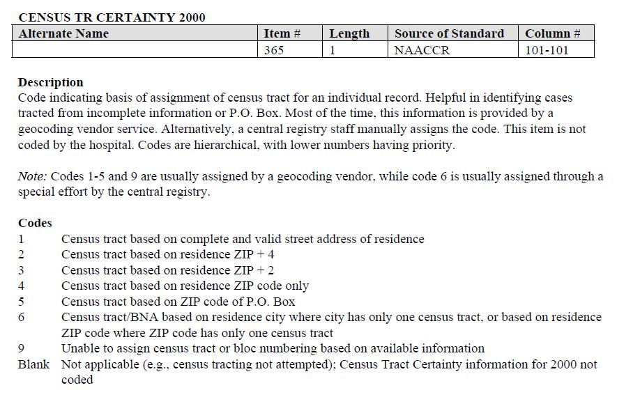
6 6 Add census tract certainty codes and GIS Coordinate Quality codes based on the geocode result (see next page for codes) 7 Repeat steps 1-6 for the remaining addresses (4-20) Add these values to the address table studyid Addr at DX-No & Street Addr at DX-City Addr at DX State Addr at DX-- Postal Code Latitude Longitude Census Tract Certainty GIS Coordinate Quality County (FIPS) Census Tract Census Block W SHORE RD Warwick RI N VIEW AVE Cranston RI DOUGLAS AVE N Providence RI POCASSET AVE Providence RI EDDY ST Providence RI SMITH ST N Providence RI ATWOOD AVE Johnston RI ADMIRAL ST Providence RI VALLEY ST Providence RI STATE ST Bristol RI EAST AVE Pawtucket RI DORIC AVE Cranston RI SEA VIEW DR Warwick RI DELTA DR Pawtucket RI 02860
7 GIS Coordinate Quality Description Code indicating the basis of assignment of latitude and longitude coordinates for an individual record from an address. This data item is helpful in identifying cases that were assigned coordinates based on incomplete information, post office boxes, or rural routes. Most of the time, this information is provided by a geocoding vendor service. Alternatively, a central registry staff manually assigns the code. This item is not coded by the hospital. Codes are hierarchical, with lower numbers having priority. Rationale Spatial analysis of cancer data often requires identifying data records with a high degree of locational precision. Researchers can use this code as a basis for selecting records with a degree of precision that is appropriate to the study. Codes 00 Coordinates derived from local government-maintained address points, which are based on property parcel locations, not interpolation over a street segment s address range 01 Coordinates assigned by Global Positioning System (GPS) 02 Coordinates are exact match of house number and street, and based on property parcel location 03 Coordinates are exact match of house number and street, interpolated over the matching street segment s address range 04 Coordinates are street intersections 05 Coordinates are at midpoint of street segments (missing or invalid building number) 06 Coordinates are address ZIP code+4 centroid 07 Coordinates are address ZIP code+2 centroid 08 Coordinates were obtained manually by looking up a location on a paper or electronic map 09 Coordinates are address 5-digit ZIP code centroid 10 Coordinates are point ZIP code of Post Office Box or Rural Route 11 Coordinates are centroids of address city (where address ZIP code is unknown or invalid, and there are multiple ZIP codes for the city) 12 Coordinates are centroid of county 98 Latitude and longitude are assigned, but coordinate quality is unknown 99 Latitude and longitude are not assigned, but geocoding was attempted; unable to assign coordinates based on available information Blank GIS Coordinate Quality not coded
8
 Open the SAS program exercise2.")
9 EXERCISE 2 Batch Geocoding Open SAS 9.1 or 9.2 Open the sas program Exercisedata.sas found in the exercise folder (e.g. C:\ NAACCRWEBINAR\EXERCISES) submit (run) the entire file This program creates the data for the exercises. N=100 fictitious Rhode Island breast cancer cases (Note: case data based on business addresses) Open the SAS program exercise2.sas ( C:\ NAACCRWEBINAR \EXERCISES\ ) Step 3 of the SAS code will format the address file which will be uploaded to the University of Southern California s (USC) geocoding service: Run Step 3 of the SAS code only (highlight only step 3 and then run) A file called 'TOGEOCODE.CSV' will be found in the directory 'C:\ NAACCRWEBINAR\ EXERCISEDATA. (Steps 4-5 use USC Geocoder) 4 Upload and verify data a. Log on to USC GEOCODER Website b. At top of page select databases upload databases c. UPLOAD NEW DATABASE Select type comma separated values (CSV) Click browse SELECT FILE 'togeocode.csv' Select text separator=comma select text qualifier=double quote click upload (DATA IS NOW UPLOADED) d. VALIDATE DATABASES: "DATABASES YOU OWN Click validate [STEP 1] 1)Click validate Database Click proceed to step 2 Click 2)Validate Table Click proceed to step 3 Review table (VERIFICATION IS COMPLETE)

10 5 a. GEOCODE DATA: At the top of page select services - Geocoding b. Select batch database geocoding c. Select your database (togeocode.csv) Click start-step 1 Click next-step 2 d. Select your database and table Click next-step 3 e. Identify address data fields id=studyid streetaddress=dxstreet city=dxcity state=dxstate zip=dxzip f. Autogenerate the remaining fields g. For output fields (optional) Select censusvalues autogenerate fields ; h. Click next step 4 ; i. Click start process (bottom of page); j. Click view process status (you may have to refresh webpage to see updates) k. Under the field 'start' click the data & time text after processing is complete. l. Click download Name the file geocodefromusc Save the file at C:\NAACCRWEBINAR\EXERCISEDATA\ Click date/time to download results Completion Status
 7 Select and Run step 7 of SAS code only Summarizes geocode match types & quality (output file= geocodefromusc4) 8 Select and Run step 8 of SAS code Joins geocoded cases to the")
11 (Steps 6-9 use SAS) 6 Select and Run step 6 of SAS code only Imports and formats geocoded records returned from USC Geocoder & code census tract certainty and geocoding quality (output file= geocodefromusc3) 7 Select and Run step 7 of SAS code only Summarizes geocode match types & quality (output file= geocodefromusc4) 8 Select and Run step 8 of SAS code Joins geocoded cases to the breast cancer data based on the id-key created in step 3 (output file=rigeocases) 9 Select and Run step 9 of SAS code Exports geocoded cases (Rigeocases) from SAS to KML format for visualization in Google Earth (output file= Rigeocases.kml) 10 (Step 10 use Google Earth) Open RIgeocases.kml file in Google Earth Click File Open Navigate to the 'exercisedata' folder (e.g C:\NAACCRWEBINAR\Exercisedata\ Select RIgeocases.kml' * You should see the files added in the Places panel;


12 EXERCISE 3 Creating and Editing Geographic Data in Google Earth (Steps 1-4 use Google Earth) 1 2 Open RIHOSPITALS.kml file in Google Earth: Click File Open Navigate to the 'exercisedata' folder C:\NAACCRWEBINAR\EXERCISEDATA\ Select RIHOSPITALS.kml' * You should see the RIHOSPITALS.kml' file added in the Places panel; You will add one missing hospital to the RIHOSPITALS.KML layer: a.type the following hospital address into the Google Earth address window: Rhode Island Hospital, 593 Eddy Street, Providence, RI b. Select the RIHOSPITALS layer in the Places panel right mouse click and select 'ADD PLACEMARK' ADD NAME: 'Rhode Island Hospital' click OK; **The addition of Rhode Island Hospital to the RIHOSPITALS layer is complete** RIHospitals layer
 right mouse click and")
13 (Steps 3-4 use Google Earth) 3 Move the placemark for Eleanor Slater Hospital to the correct location: Locate Eleanor Slater Hospital by locating this hospital in Google Earth Places panel Select Eleanor Slater Hospital double mouse click Google Earth will fly to Eleanor Slater Hospital Move the cursor over the top of the Eleanor Slater Hospital placemark (red cross) right mouse click and select properties Move the placemark northeast about 700 feet from its current location (building looks like a cross) click ok Move Placemark 4 Save Edits. Select RIHOSPITALS in the Places panel right mouse click select Save Places As - EDITED_HOSPITALS Save as Type KML
14 (Steps 5-6 use SAS) 5 Import the RIHOSPITALS_EDITS.KML file into SAS Select and Run step 7 of SAS code 6 Open the SAS file RIEDITED_HOSPITALS and note Rhode Island Hospital and the changed coordinates for Eleanor Slater Hospital ;
15 (Steps 1-8 use SAS) EXERCISE 4 Calculating Distances Between Locations (Example: Census Tract Centroids To Hospitals) 1 Open the SAS program exercise4 : (C:\ NAACCRWEBINAR \EXERCISES\) 2 Merge (Join) census tract centroids to geocoded RI breast cancer case file (geocases) Select and Run step 2 of SAS code (output file= GEOCASES_DIST) 3 Get only unique census tracts (reduces process time for distance combinations) Select and Run step 3 of SAS code (output file= UNIQUETRACTS) 4 Get unique combinations of census tracts & hospitals for distance calculations. -For this exercise we are testing all n*n combinations, however to reduce the number of combinations it is possible to select n nearest neighbors first using great circle distance calculations. In this example: 16 hospitals * 74 tracts =1184 combinations. Select and Run step 4 of SAS code (output file= UNIQUETRACTSCOMBO)
16 5 Send records to google.maps (from census tract centroid (latcentroid, longcentroid) to hospital (hosplat, hosplong); Select and Run step 5 of SAS code (output file=distance) *processing time is around 7-10 minutes Note that in this exercise we are not sending any case records to google (only census tract centroid and hospital locations for each unique comparison [this is public information]. Cases records should only be sent to vendors that have security and encryption. Data sent to google.com is not encrypted. Within the next few months NAACCR will offer a secure service to registries to calculate driving distances and time for individual cases as part of the Komen project. 6 Select closest hospital from each census tract centroid Select and Run step 6 of SAS code (output file= Distance4) 7 Merge closest hospital to case data based on census tract variable [stcountytract] Select and Run step 7 of SAS code (output file= geocases_final) 8 Summary statistics comparing great circle distance and driving distance measures Select and Run step 8 of SAS code Review the statistics in the output: What is the correlation coefficient between driving distance and GCD?
NAACCR Geocoding Tutorial
 NAACCR Geocoding Tutorial Introduction The goal of the tutorial is to familiarize you with the NAACCR online geocoder. The NAACCR geocoder can be used to geocode one address at a time or in batch mode
Address Management User Guide. PowerSchool 6.0 Student Information System
 User Guide PowerSchool 6.0 Student Information System Released June 2009 Document Owner: Document Services This edition applies to Release 6.0 of the PowerSchool Premier software and to all subsequent
Address Management User Guide. PowerSchool 8.x Student Information System
 PowerSchool 8.x Student Information System Released July 2014 Document Owner: Documentation Services This edition applies to Release 8.0.1 of the PowerSchool software and to all subsequent releases and
Welcome to Cole On-line Help system!
 Welcome to Cole On-line Help system! Cole Online is an Internet based information directory that allows fast and efficient access to demographic information about residences and businesses. You can search
Tutorial for Lane County Mapping Applications
 Tutorial for Lane County Mapping Applications Contents Overview... 2 Tools... 2 Navigation Tools... 3 Display Tools... 5 Information Tools... 6 Sharing Tools... 7 Common Tasks... 9 Identify or Show Data
Greenville County Internet Mapping System User s Guide
 Greenville County Internet Mapping System User s Guide Version 2.0 Greenville County Geographic Information Systems May 30, 2006 Table of Contents NAVIGATING TO THE ONLINE MAPPING APPLICATIONS...- 3 -
RAPIDMAP Geocortex HTML5 Viewer Manual
 RAPIDMAP Geocortex HTML5 Viewer Manual This site was developed using the evolving HTML5 web standard and should work in most modern browsers including IE, Safari, Chrome and Firefox. Even though it was
Data to App: Web,Tablet and Smart Phone Duane Griffith, Montana State University,
 Data to App: Web,Tablet and Smart Phone Duane Griffith, Montana State University, griffith@montana.edu This tutorial is broken into several steps related mostly to the technology applied at each step.
Geodatabases. Dr. Zhang SPRING 2016 GISC /03/2016
 Geodatabases Dr. Zhang SPRING 2016 GISC 1401 10/03/2016 Using and making maps Navigating GIS maps Map design Working with spatial data Spatial data infrastructure Interactive maps Map Animations Map layouts
- Hold down the 'Shift' key and click and drag the mouse to create a red box which will zoom to that area when released.
 Basic navigation and zoom: To Pan around the map: - Click anywhere on the map and hold the button down until 4 directional arrows appear which will then allow the mouse to be moved in any direction panning
Google Earth Maps. Creating an Outdoor Location Using Google Earth. Understanding Geographical Coordinates for Google Earth CHAPTER
 CHAPTER 18 Within Monitor >, you can create an outdoor location, import a file, view Google Earth maps, and specify Google Earth settings. Creating an Outdoor Location Using Google Earth Importing a File
SAGIS Property Map Viewer Instruction Manual Instructions for using the SAGIS Property Map Viewer. Published December 21, 2018.
 SAGIS Property Map Viewer Instruction Manual www.sagis.org/map Instructions for using the SAGIS Property Map Viewer. Published December 21, 2018. 1 Instructional Videos Click on a link to watch a video
Using Google Earth. Middlebury College Library and Information Services
 Using Google Earth Middlebury College Introduction: While Google Earth can be a fun tool for simply looking at the surface of the earth, there are many other more sophisticated features to explore. Google
TMS Quick Help Guide
 TMS Quick Help Guide www.ms2soft.com Table of Contents 1.0 Introduction 1 2.0 New Locations 3 2.1 New TCDS Locations 4 2.2 New TSMS Locations 8 3.0 Administration Page 11 3.1 TCDS Admin Page 11 3.2 TSMS
Topic 1: Getting started Topic 2: Finding a location... 5
 Navigating LISTmap Topic 1: Getting started... 3 1. What is LISTmap?... 3 2. Compatible browsers... 3 3. A quick look at LISTmap... 3 Topic 2: Finding a location... 5 1. Using the search bar... 5 2. Zooming...
St. Joseph County. GIS Department FetchGIS Web Map Tutorial
 St. Joseph County GIS Department FetchGIS Web Map Tutorial 2 Table of Contents Contents Slide #(s) Where to Find the Web Map 3 Disclaimer 4 Turning On and Off Map Layers 5 Searching for Parcels 6 More
How to calculate population and jobs within ½ mile radius of site
 How to calculate population and jobs within ½ mile radius of site Caltrans Project P359, Trip Generation Rates for Transportation Impact Analyses of Smart Growth Land Use Projects SECTION PAGE Population
Data Visualization Techniques with Google Earth
 Data Visualization Techniques with Google Earth E-Learning for the GIS Professional Any Time, Any Place! geospatialtraining.com Course Outline Module 1: Google Earth Pro Fundamentals Module 2: Adding Features
1. Open the New American FactFinder using this link:
 Exercises for Mapping and Using US Census Data MIT GIS Services, IAP 2012 More information, including a comparison of tools available through the MIT Libraries, can be found at: http://libraries.mit.edu/guides/types/census/tools-overview.html
MS2. Modern Traffic Analytics ms2soft.com
 MS2 Modern Traffic Analytics ms2soft.com Updated: October 31, 2014 The Traffic Count Database System (TCDS) module is a powerful tool for the traffic engineer or planner to organize an agency's traffic
Georeferencing Tutorials and Recommended Practices
 March 21, 2008 Georeferencing Tutorials and Recommended Practices Topic Page Introduction 1 Preparing address data for georefernecing 1 Available address geocoders, pros and cons 1 Using Batchgeocode.com
PlaceMap. Accommodation. Slide 1
 PlaceMap for Accommodation Slide 1 PlaceMap Using the power of Google Earth to store and display all of your spatial data in a much more dynamic way Google Earth is a free software program that lets you
City of La Crosse Online Mapping Website Help Document
 City of La Crosse Online Mapping Website Help Document This document was created to assist in using the new City of La Crosse online mapping sites. When the website is first opened, a map showing the City
Geocoding Reference USA data in ArcMap 9.3
 Tufts GIS Tip Sheet Geocoding Reference USA data in ArcMap 9.3 Written by Barbara Parmenter Revised 3/1/2011 In this exercise, you will map businesses or services for a town in the Boston metropolitan
Completing Baseline s Site Survey Request Form
 Completing Baseline s Site Survey Request Form The first step in successfully implementing a radio network for your irrigation controllers is to identify the proposed locations for each radio. These radios
Major features Support multi-language Automatically match photo and GPS tracks by time synchronization. Add photo comments.
 Users Manual V1.1 Users Manual Major features Read GPS log from device Add Photo and photo management Auto match photo and waypoints in tracks Shift photo time View in Google earth Save as kmz file GeoTag
Table of Contents Website Layout Website Tools
 Help Dialogue Welcome to the Vanderburgh County Assessor s Web Map! This website is a very useful resource for searching and research on properties within Vanderburgh County, Indiana. This help dialogue
Google Earth Tutorial 1: The Basics of Map-making in Google Earth 6.2
 Google Earth Tutorial 1: The Basics of Map-making in Google Earth 6.2 University of Waterloo Map Library, 2012 Part 1: Placemarks 1. Locating a Geographical Area a. Open up Google Earth. b. In the Search
MS2. Modern Traffic Analytics ms2soft.com
 MS2 Modern Traffic Analytics ms2soft.com Updated: October 31, 2014 Table of Contents 1 Introduction 3 2 Search Types 6 3.1 Search by: Study Location 11 3.2 Search by: Crash Data 12 3.3 Search Results Page
The Data Journalist Chapter 7 tutorial Geocoding in ArcGIS Desktop
 The Data Journalist Chapter 7 tutorial Geocoding in ArcGIS Desktop Summary: In many cases, online geocoding services are all you will need to convert addresses and other location data into geographic data.
QUICK HELP GUIDE. Traffic Signal Management System (TSMS) Modern Traffic Analytics
 Modern Traffic Analytics") QUICK HELP GUIDE Traffic Signal Management System (TSMS) Modern Traffic Analytics www.ms2soft.cotm Table of Contents 1.0 Introduction...1 2.0 Search Types...4 3.0 Map Interactions...5 4.0 Reports...8 5.0
QUICK HELP GUIDE Traffic Signal Management System (TSMS) Modern Traffic Analytics www.ms2soft.cotm Table of Contents 1.0 Introduction...1 2.0 Search Types...4 3.0 Map Interactions...5 4.0 Reports...8 5.0
Rainforest Alliance. Spatial data requirements and guidance. June 2018 Version 1.1
 Rainforest Alliance Spatial data requirements and guidance June 2018 Version 1.1 More information? For more information about the Rainforest Alliance, visit www.rainforest-alliance.org or contact info@ra.org
ArcMap and Google Earth
 ArcMap and Google Earth Prepared by Andrew Hobby CVEN 658 November 25, 2008 Contents: Brief Overview of Google Earth Goals of Exercise Computer and Data Requirements Procedure: 1. Creating a KML File 2.
GIS Virtual Workshop: Geocoding
 This module will deal with the concept of geocoding of data. Geocoding is placing a data point which does not have a X, Y reference (no Latitude and Longitude) and automatically mapping it by knowing the
Overview of ArcGIS Online Applications. Champaign County
 Overview of ArcGIS Online Applications Champaign County Champaign County GIS Consortium Updated: April 2017 Table of Contents ArcGIS Online Application Overview... 3 Map Interface Symbology and Terminology...
Overview of SAS/GIS Software
 3 CHAPTER 1 Overview of SAS/GIS Software Introduction to Geographic Information Systems 3 Features of SAS Software 4 Data in SAS/GIS Applications 5 Spatial Data 5 Spatial Data Layers 6 Spatial Data Coverages
NJUNS 2018 USER GUIDE
 NJUNS 2018 USER GUIDE Key Differences in the New System... 4 Data Migration... 4 Login... 5 Dashboard... 5 Header Menu... 5 Working with Tickets... 6 Tickets... 6 Adjust the number of Rows displayed per
GIS Change Requests: Web Base change requests will replace MSAG Update paper form.
 GIS Change Requests: Web Base change requests will replace MSAG Update paper form. Types of edits that will need to be reported Individual address edits (move, delete, add or change) Road edits (add, delete,
WOMEN'S INTERAGENCY HIV STUDY SECTION 40: GEOCODING PROTOCOL
 WOMEN'S INTERAGENCY HIV STUDY SECTION 40: GEOCODING PROTOCOL A. BACKGROUND & STUDY PURPOSE This study will investigate how socioeconomic context and health care coverage contribute to health outcomes among
Google Earth II: Create a tour with Google Earth
 Google Earth II: Create a tour with Google Earth This workshop is a continuation of The Google Earth Workshop I: Map-making Basics. You will create a tour to show the main and satellite campuses of the
MS2. Modern Traffic Analytics ms2soft.com
 MS2 ms2soft.com Updated: October 31, 2014 The Traffic Crash Location System (TCLS) was designed to manage all crash statistics and crash events within a designated area. This guide is intended for users
Chapter 7. A Quick Tour of ArcGIS Pro
 Chapter 7 A Quick Tour of ArcGIS Pro Skills you will learn: This tutorial is intended to get you going using ArcGIS Pro, a new desktop application that is part of ArcGIS Desktop. A separate tutorial gives
PRINTING GROWER FIELD MAPS OFF THE WEB
 PRINTING GROWER FIELD MAPS OFF THE WEB 3-29-2018 A. Google Earth: Very easy to use; easy to print map (either directly or via extraction to Word); easy to scale up or down; locator makes finding field
Georeferencing. Georeferencing: = linking a layer or dataset with spatial coordinates. Registration: = lining up layers with each other
 Georeferencing How do we make sure all our data layers line up? Georeferencing: = linking a layer or dataset with spatial coordinates Registration: = lining up layers with each other Rectification: The
US Geo-Explorer User s Guide. Web:
 US Geo-Explorer User s Guide Web: http://usgeoexplorer.org Updated on October 26, 2016 TABLE OF CONTENTS Introduction... 3 1. System Interface... 5 2. Administrative Unit... 7 2.1 Region Selection... 7
Geocoding vs. Add XY Data using Reference USA data in ArcMap
 Geocoding vs. Add XY Data using Reference USA data in ArcMap 10.4.1 Written by Barbara Parmenter. Revised by Carolyn Talmadge 2/27/2017 GETTING BUSINESS DATA FROM REFERENCE USA BY NAICS AND CITY... 2 MODIFY
NJUNS 2018 USER GUIDE
 NJUNS 2018 USER GUIDE Key Differences in the New System... 4 Data Migration... 4 Login... 5 Dashboard... 5 Header Menu... 5 Working with Tickets... 6 Tickets... 6 Adjust the number of Rows displayed per
FrontCounter BC Discovery Tool Instructions. NOTE: You must have Google Earth installed to use this tool.
 NOTE: You must have Google Earth installed to use this tool. These instructions are written for use with a Microsoft Windows Work Station. This tutorial will step you through navigating to and viewing
Los Angeles Cancer Surveillance Program. Links and Slides google Rich Pinder USC.
 Rich Pinder Los Angeles Cancer Surveillance Program Links and Slides google Rich Pinder USC rpinder@usc.edu NAACCR Annual Meeting Incorporating realtime geocoding systems into data entry routines Presented
Full Search Map Tab. This map is the result of selecting the Map tab within Full Search.
 Full Search Map Tab This map is the result of selecting the Map tab within Full Search. This map can be used when defining your parameters starting from a Full Search. Once you have entered your desired
Tips on Excel. Discover some tips to organize and lay out your Excel file and convert it into a CSV or PDF file.
 Tips on Excel Your business partners or retailers are listed in an Excel file and you want to put them on an interactive map? It's simple with the Click2map's Editor. A simple import process exists to
GeocodeDVD User Guide
 GeoLytics GeocodeDVD User Guide Installation 1 Introduction 2 How does GeocodeDVD work? 2 Interface layout of the screen 2 Manual Geocoding 3 Batch Geocoding 5 Geocoding Options Optimizing Your Results
GIS DATA SUBMISSION USER GUIDE. Innovation and Networks Executive Agency
 Innovation and Networks Executive Agency GIS DATA SUBMISSION USER GUIDE Innovation and Networks Executive Agency (INEA) W910 Chaussée de Wavre 910 B-1049 Brussels, Belgium Tel: +32 (0)2 29 95252 Fax: +32
PWC County Mapper XM User Instruction (AS OF 12/03/2009)
") PWC County Mapper XM User Instruction (AS OF 12/03/2009) MAP NAVIGATION There are several ways to navigate the map, you can use your keyboard/mouse combination, use the Navigation toolbar, use the slider
PWC County Mapper XM User Instruction (AS OF 12/03/2009) MAP NAVIGATION There are several ways to navigate the map, you can use your keyboard/mouse combination, use the Navigation toolbar, use the slider
Microsoft Office 2016 Mail Merge
 Microsoft Office 2016 Mail Merge Mail Merge Components In order to understand how mail merge works you need to examine the elements involved in the process. In any mail merge, you'll deal with three different
Georeferencing a Scanned Map Image (FIP maps)
") MAP, DATA & GIS LIBRARY maplib@brocku.ca Georeferencing Scanned FIP Maps ArcMap Georeferencing a Scanned Map Image (FIP maps) These instructions offer an exercise in georeferencing historical scanned map
MAP, DATA & GIS LIBRARY maplib@brocku.ca Georeferencing Scanned FIP Maps ArcMap Georeferencing a Scanned Map Image (FIP maps) These instructions offer an exercise in georeferencing historical scanned map
Using Syracuse Community Geography s MapSyracuse
 Using Syracuse Community Geography s MapSyracuse MapSyracuse allows the user to create custom maps with the data provided by Syracuse Community Geography. Starting with the basic template provided, you
Mapping Tabular Data Display XY points from csv
 Mapping Tabular Data Display XY points from csv Materials needed: AussiePublicToilets.csv. [1] Open and examine the data: Open ArcMap and use the Add Data button to add the table AussiePublicToilets.csv
Manitowoc County, WI Advanced Access GIS Viewer User Documentation
 Manitowoc County, WI Advanced Access GIS Viewer User Documentation Introduction Extensive time was put into developing this website both from a display, and from a printing and scaling perspective. This
Table of Contents. Map Layout... 5 Layer List - Default... 6 Identify... 7 Search Method... 8
 Table of Contents Map Layout... 5 Layer List - Default... 6 Identify... 7 Search Method... 8 1. Targeted Search... 8 2. Query Tool... 11 A. Select Parcel by entering Parcel Number... 12 B. Select Parcel
Geocoding for Beginners. November 18, 2013 Christine Murray University of Pennsylvania, Van Pelt Library
 Geocoding for Beginners November 18, 2013 Christine Murray University of Pennsylvania, Van Pelt Library chrmur@upenn.edu Overview What is geocoding? Two tools: BatchGeo Geo for Google Docs No GIS software
Data East, LLC. Using CarryMap mobile maps on ios devices (iphones, ipads, ipods touch)
") Data East, LLC Using CarryMap mobile maps on ios devices (iphones, ipads, ipods touch) TABLE OF CONTENTS 1. Downloading map files to mobile device... 3 1.1 Copy.cmf file to CarryMap Observer mobile application
Data East, LLC Using CarryMap mobile maps on ios devices (iphones, ipads, ipods touch) TABLE OF CONTENTS 1. Downloading map files to mobile device... 3 1.1 Copy.cmf file to CarryMap Observer mobile application
This worksheet will walk you through the basics of creating a digital map using CARTO, a cloud-based GIS and web mapping tools platform.
 MappingBasics This worksheet will walk you through the basics of creating a digital map using CARTO, a cloud-based GIS and web mapping tools platform. The goals of this exercise are: Learn how to geocode
iii Map Intelligence Client User Manual
 Map Intelligence Client User Manual iii Map Intelligence Client User Manual ii CONTENTS INTRODUCTION... 5 Purpose... 5 Audience... 5 Conventions... 6 Prerequisites... 6 CONCEPTS... 7 What is Map Intelligence?...
Match and Location Codes
 Centrus GeoStan Match and Location Codes Version 28.00 For Windows, UNIX/Linux, z/os April 2015 2015 Pitney Bowes Software Inc. All rights reserved. Pitney Bowes Software Inc. is a wholly-owned subsidiary
COGCC GIS Online Map Instructions - Internet Site April 10, 2018
 COGCC GIS Online Map Instructions - Internet Site April 10, 2018 Table of Contents Page Section Page Section 1 Introduction 8 Clear Selection 2 Double Click 8 Buffer 3 Arrow Tip Information 9 Select within
User Guide Version 2.1 August 8, IMAPP, Inc. Technical Support: Monday Friday 8:00 AM 5:00 PM Phone: (888) IMAPP.
 IMAPP.") User Guide Version 2.1 August 8, 2008 IMAPP, Inc. Technical Support: Monday Friday 8:00 AM 5:00 PM Phone: (888) 462-7701 Email: support@ IMAPP.com www.imapp.com Index Accessing IMAPP... 3 Log in to IMAPP...
User Guide Version 2.1 August 8, 2008 IMAPP, Inc. Technical Support: Monday Friday 8:00 AM 5:00 PM Phone: (888) 462-7701 Email: support@ IMAPP.com www.imapp.com Index Accessing IMAPP... 3 Log in to IMAPP...
Geocoding Address Data
 Geocoding Address Data First, you need to download the dataset for this exercise from out web server at http://www.library.yale.edu/mapcoll/beta/files/data/geocode_data.zip. Create a folder (use your initials
NJUNS Users Guide.
 NJUNS Users Guide www.njuns.com The National Joint Utilities Notification system, NJUNS, is a national organization of member utilities formed for the purpose of improving the coordination of joint ventures.
Geographical Information Systems Institute. Center for Geographic Analysis, Harvard University
 Geographical Information Systems Institute Center for Geographic Analysis, Harvard University LAB EXERCISE 5: Queries, Joins: Spatial and Non-spatial 1.0 Getting Census data 1. Go to the American Factfinder
COMMISSION OF TEXAS MAY
 GIS Viewer RAILROAD COMMISSION OF TEXAS MAY 2017 Table of Contents GIS Viewer Basics... 1 Basics... 1 Screen Overview... 2 Tools... 5 Visibility... 5 Measure Tool... 7 Identify Tool... 10 Coordinates Tool...
STORE LOCATOR PLUGIN USER GUIDE
 support@simicart.com Support: +84.3127.1357 STORE LOCATOR PLUGIN USER GUIDE Table of Contents 1. INTRODUCTION... 3 2. HOW TO INSTALL... 4 3. HOW TO CONFIGURE... 5 4. HOW TO USE ON APP... 13 SimiCart Store
Number Screen Element. App Lake County Logo: Displays the logo for Lake County, Colorado.
 The Main Screen When you open any of the Lake County maps, a screen similar to the one below will appear. The buttons at the bottom will vary between maps, the order will remain similar. Number Screen
Excel To KML - Display Excel files on Google Earth.
 Page 1 of 6 Earth Point Real Estate Home Introduction Q & A County Records Property Search County GIS Utilities Township & Range Excel To KML Around Town Press Blog About Local Homes, Global View Home
Analysing crime data in Maps for Office and ArcGIS Online
 Analysing crime data in Maps for Office and ArcGIS Online For non-commercial use only by schools and universities Esri UK GIS for School Programme www.esriuk.com/schools Introduction ArcGIS Online is a
iii Map Intelligence Client User Manual
 Map Intelligence Client User Manual iii TM Map Intelligence Client User Manual ii CONTENTS INTRODUCTION... 5 Purpose... 5 Audience... 5 Conventions... 6 Prerequisites... 6 CONCEPTS... 7 What is Map Intelligence?...
MAKING MAPS WITH GOOGLE FUSION TABLES. (Data for this tutorial at
 MAKING MAPS WITH GOOGLE FUSION TABLES (Data for this tutorial at www.peteraldhous.com/data) Thanks to Google Fusion Tables, creating maps from data and embedding them on a web page is now easy. We re going
A Google Earth User Manual for Earth Science Teachers
 A Google Earth User Manual for Earth Science Teachers Eric J. Fermann Eastchester High School Eric J. Fermann, 2006 TABLE OF CONTENTS Table of Contents... 1 Introduction... 2 Getting and Installing Google
Connect America Fund Webinar: Filing with the HUBB Portal. High Cost Program December 13, 2017
 Connect America Fund Webinar: Filing with the HUBB Portal High Cost Program December 13, 2017 1 Housekeeping Use the Audio section of your control panel to select an audio source Turn on your computer
Understanding Physical Address Geocoder Results
 Understanding Physical Address Geocoder Results March 21, 2014 Document Version 0.1 This document explains how to use the output of the Physical Address Geocoder to improve the quality of your addresses.
Using the Kendall County GIS CAMA/Sales GIS Viewer
 Using the Kendall County GIS CAMA/Sales GIS Viewer Link to Viewer Gallery: http://gis.co.kendall.il.us/gisviewer_gallery.aspx Help and About Initial View Introduction Navigation Identify Tool Search Tool
ArcGIS Online (AGOL) Quick Start Guide Fall 2018
 Quick Start Guide Fall 2018") ArcGIS Online (AGOL) Quick Start Guide Fall 2018 ArcGIS Online (AGOL) is a web mapping tool available to UC Merced faculty, students and staff. The Spatial Analysis and Research Center (SpARC) provides
ArcGIS Online (AGOL) Quick Start Guide Fall 2018 ArcGIS Online (AGOL) is a web mapping tool available to UC Merced faculty, students and staff. The Spatial Analysis and Research Center (SpARC) provides
GIS DATA SUBMISSION USER GUIDE. Innovation and Networks Executive Agency
 Innovation and Networks Executive Agency GIS DATA SUBMISSION USER GUIDE Innovation and Networks Executive Agency (INEA) W910 Chaussée de Wavre 910 B-1049 Brussels, Belgium Tel: +32 (0)2 29 95252 Fax: +32
National Monuments Service: Wreck Database Viewer
 National Monuments Service: Wreck Database Viewer Introduction HELP DOCUMENT Welcome to the Wreck Viewer map / search facility that provides access to the records of wrecks held by the National Monuments
Getting Started with ArcGIS Background and Introduction
 Getting Started with ArcGIS Background and Introduction BACKGROUND ON ArcGIS SOFTWARE ArcGIS is a set of tools for collecting, storing, managing, analyzing, and representing geographic information. It
GeoLytics. User Guide. Online Demographic Database
 GeoLytics Online Demographic Database User Guide Introduction 1 Steps to Create a Report and Export Data 1 Creating & Naming a Request 2 Selecting an Area 3 Selecting the Subarea 5 Selecting Counts & Variables
ReboGateway. training manual
 ReboGateway training manual March 8, 2012 CONTENTS 1.1 Description 2.1-2.3 FAQ 3.1-3.3 Register 4.1-4.5 Specific Lead Search - County Search 5.1-5.3 Tract Utility 6.1-6.4 Creating a Farm to Watch 7.1-7.3
Find nearest dealer. Users guide
 Find nearest dealer Users guide January 2017 Digital Media, Group Marketing 1 Table of contents 1. Access to backend... 3 2 Front page... 4 2.1 Left navigation... 5 3 Stockists... 6 3.1 Overview... 6 3.2
Efficient Geocoding with ArcGIS Pro
 What you will need: An ArcGIS Online for organizations account ArcGIS Pro Efficient Geocoding with ArcGIS Pro By Mike Price, Entrada/San Juan, Inc. Public safety organizations rely on reliable, repeatable
Programming Team Report
 Programming Team Report George Carpeni, Chetan Naratain, James Tate, Will Peng (and John Valentino) 1 1 Summary of Process 1.1 Project Process Figure 1: Project Process Schematic 2 1. Students look up
v9 Quick Start Guide
 v9 Quick Start Guide overview Driving Screen Most of your time using CoPIlot Truck will be spent on this screen. Let s take a moment and get familiar with the items you can interact with. Zoom Out Zoom
Google Earth. Tutorials. Tutorial 2: Annotating Google Earth
 Google Earth Tutorials Tutorial 2: Annotating Google Earth Google Earth makes it easy to create a map with annotations - you can add placemarks (points), paths (lines), polygons in Google Earth, and add
-In windows explorer navigate to your Exercise_4 folder and right-click the DEC_10_SF1_P1.csv file and choose Open With > Notepad.
 BIOL 4460/5460 and GEOL 4460 Introduction to GIS LAB 4 MAKING A THEMATIC MAP This exercise is to show you how to create a map for printing. As you have seen in the lecture, maps can have different purposes
Lab 6: Transforming Spatial Data
 Lab 6: Transforming Spatial Data Objectives: The primary objectives of this lab are to georeference a raster dataset and to create GIS data by digitizing features from an image as a backdrop. Specifics:
Introduction to Social Explorer
 Introduction to Social Explorer Janine Billadello, Geospatial Data Lab, Baruch College October 1, 2015 Abstract This tutorial will introduce you to Social Explorer, an online mapping interface that allows
Downloading shapefiles and using essential ArcMap tools
 CHAPTER 1 KEY CONCEPTS downloading shapefiles learning essential tools exploring the ArcMap table of contents understanding shapefiles customizing shapefiles saving projects Downloading shapefiles and
Introduction to GIS & Mapping: ArcGIS Desktop
 Introduction to GIS & Mapping: ArcGIS Desktop Your task in this exercise is to determine the best place to build a mixed use facility in Hudson County, NJ. In order to revitalize the community and take
Working with Google Earth
 Working with Google Earth The Places panel in Google Earth serves as a repository to bookmark locations that you want easy access to. There are two folders located in Places: My Places and Temporary Places.
Lab #7: Mapping US Census Data
 Lab #7: Mapping US Census Data Objectives: Access US Census Data via the Web Download census data in excel format Create new variables based on calculations Create key fields for merging with NYC Planning
Create Geomark in Google Earth Tutorial
 Create Geomark in Google Earth Tutorial General business example a potential applicant / user wants to create an area of interest that can be shared electronically to another party eg: another agency,