Data Visualization Techniques with Google Earth
|
|
|
- Brittney Cain
- 5 years ago
- Views:
Transcription

1 Data Visualization Techniques with Google Earth E-Learning for the GIS Professional Any Time, Any Place! geospatialtraining.com
2 Course Outline Module 1: Google Earth Pro Fundamentals Module 2: Adding Features to the Map Module 3: Attaching Information to Features Module 4: Adding Neighborhood Information Module 5: Creating Thematic and 3D Maps Module 6: Presentation and Communication Module 7: Adding Images to the Display Module 8: Sharing your Data Module 9: Terrain Information Module 10: Using Historical Imagery 2
3 GOOGLE EARTH PRO FUNDAMENTALS 3
4 Module Outline Navigation Creating Features Search Places and Layers Panel Understanding KML Overview of Google Earth Pro Features 4
5 Navigation Many ways to navigate User interface components Mouse Keyboard Can zoom, pan, tilt, change orientation, rotate Demonstration 5

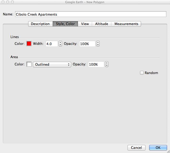
6 Creating Placemarks Add Placemark tool Click a location on the GE display Can change Icon Style and color View Altitude 6


7 Extruding a Placemark May be times when you want the icon to hover above the property Known as tethering String (or tether) drawn between the Placemark and the physical location Use Altitude tab Set altitude and absolute Check Extend to ground 7


8 Creating Paths Add Path tool Draw two or more points and a path will automatically connect the points Automatically calculates distance of path 8


9 Creating Polygons Add Polygon tool Create a set of points that define the polygon Double click the last point to close the polygon 9
 Latitude, Longitude (Degrees, Minutes, Seconds) Free form (Museums in New York")
10 Search Panel Google Earth recognizes the following search types City, State City, Country Number, Street, City, State Zipcode or Postal Code Latitude, Longitude (Decimal Degrees) Latitude, Longitude (Degrees, Minutes, Seconds) Free form (Museums in New York City) 10


11 Places Panel Contains temporary datasets Temporary Places folder Only used for current GE session Removed when you close GE Datasets saved to your local computer My Places Persist between sessions Right click a layer from Temporary Places folder and select Save to My Places 11

12 Layers Panel Contains Google provided datasets Created by Google or its content partners Always available in GE Can t add your layers to the Layers panel 12
13 Keyhole Markup Language or KML XML grammar and file format for modeling and storing geographic features Tag based structure (XML) Similar to HTML Can be created in Google Earth, XML editors, or text editors (jedit, Notepad++) Can be shared What is KML? 13
14 Open GeoSpatial Consortium and KML KML originally created by a company called Keyhole for it s Earth Viewer Later acquired by Google KML specification now controlled by Open Geospatial Consortium (OGC) Currently at KML version 2.2 Continues to evolve under OGC 14
15 KML Functionality Specify icons and labels on the earth s surface Define unique views using camera positions Drape images over the terrain Specify feature appearance with styles Write HTML descriptions of features, including hyperlinks and embedded images Use folders for grouping features Fetch data from remote servers Much more! 15

16 Reach a Wide Audience Google Earth KML files can be distributed via the web Users download files from the Internet Users can find KML files using Google Search XML Sitemap notifies Google to crawl your geo content Can also use GeoRSS KML search results also returned in Google Earth KML files found when doing a search in Google Earth for California wildfires 16
17 Data is Easy to Distribute All content contained within KML or KMZ file Can be distributed via Internet Network Server Web Services 17
.")
18 KML Files What does a KML file look like? Below is a small sub-set of a KML file that defines a map overlay (Ground Overlay). Notice that it looks very similar to HTML Tags ARE case-sensitive 18
19 KML vs KMZ KML files can get VERY large when dealing with large datasets This is due to the amount of text that it takes to describe GE features Need a way to compress these files to make them smaller KMZ files are the compressed versions of KML files KMZ files also used to distribute additional files referenced by a main KML file Images, icons, textures, models, HTML GE can read KML or KMZ files Can open KMZ files with tools such as WinZip 19
20 ADDING FEATURES TO THE MAP 20
21 Module Outline Address geocoding Adding all your properties to Google Earth using geocoding Adding properties manually as points Creating land parcels as polygons 21

22 What is Geocoding? Process of converting physical addresses into geographic coordinates Address can t be added to map without geographic coordinates Example: 1202 Sand Wedge, San Antonio, TX = ,
23 High Precision Rooftop Geocoding Accuracy Levels Fallback Street Segment Geometric Center Approximate Low Precision 23
24 Rooftop Geocoding Also called point-level geocoding Most accurate determination More accurate for long street segments, cul-de-sacs, or irregularly spaced addresses Assigns a geographic coordinate to the actual rooftop of an address 24
25 Street Segment Geocoding Assigns latitude/longitude coordinates based on know geocodes at the intersection of the block or street segment containing an address Uses a process of interpolation Example: If a block runs from Main Street, then 150 Main Street would be approximately halfway between 100 and 200 Main Street Most commonly used method at this time More accurate in urban areas Rural areas are less complete Longitude: , Latitude: Main St. 25
26 GE Pro can import a text file containing a batch set of addresses Text file is typically delimited by a comma or tab Supported countries United States, United Kingdom, Canada, France, Italy, Germany, Spain Each address converted into a Placemark Geocoding in Google Earth Pro 26

27 Geocoding in Google Earth Pro Starts with a text file containing addresses Address components can be in separate columns or a single column 27


28 Geocoding in Google Earth Pro Go to File Import Find the file and open Data Import Wizard 28

29 Geocoding in Google Earth Pro Other dialogs: Select latitude/longitude fields Address field information Specify field types 29


30 Some Addresses Won t Geocode Not all addresses will geocode PO Boxes, Apartments, Suite Numbers New Addresses Misspellings and typos Can repair addresses in Google Earth 30


31 Defining the Address Placemark Icon Can apply a style template to the features Can define Name Defines how the Placemark will be labeled Color Icon color Icon Style Height Clamp features to ground or set height from a field 31

32 Geocoding Results Addresses added as Placemarks Saved in a KML file 32
33 Exercise Please complete the following exercise: Adding Addresses to Google Earth with Geocoding 33

34 Adding Features Manually Use the Add Placemark tool Click the location of the feature in GE Demonstration 34


35 Styling the Feature Features can be styled by changing the icon Click the icon button to display list of icons Can also add your own custom icons Increase or decrease size of icon Use Scale property Default is 1.1 (higher number increases size) 35

36 Custom Icons Can add your own custom icons Many available on the web Map icons collection KML4Earth 36


37 Creating Polygons Demonstration 37
38 Perimeter and Area of a Polygon Measurements tab Automatically determines perimeter and area Can change units of measurement Feet, miles, meters, etc 38
39 Exercise Please complete the following exercise: Manually Creating Features with Google Earth 39
40 ADDING FEATURE INFORMATION 40
41 Module Outline Styling your icons Introduction to info balloons Adding text, photos, video, links to info balloons Using templates to create info balloons 41


42 Styling Properties with Icons Placemarks can be styled with icons Google Earth provides many icons You can also supply your own 42

43 Introduction to Balloons Balloons provide a way of communicating information about a place to your users Attached to Placemarks Can include Plain text, HTML, photos, video, links to files Excellent tool for presenting feature information to users Detailed information, photos, video, your logo 43

44 Add information to balloons by editing Placemark Select Placemark and then Get Info Description tab Adding Information to Info Balloons 44


45 The <a> HTML element used to add a link to the balloon Adding a Link to the Info Balloon 45

46 Can also link to PDF and other file formats Use <a> HTML element Provide a URL to the file Adding a Link to a PDF File to an Info Balloon 46

47 The <img> HTML element adds an image to the balloon Adding a Photo to an Info Balloon 47

48 Adding Video to an Info Balloon Use <iframe> HTML element to add video to an info balloon 48
49 Exercise Please complete the following exercise: Adding Feature Information to Info Balloons 49
50 ADDITIONAL DATASETS 50
51 Module Outline Demographic information Parcel information Traffic counts Importing GIS datasets Styling imported datasets 51
 Projections (2016) Age, education, gender, households, income, marital status, vehicle")
52 Demographic Information Google Earth Pro includes census demographic information Layers Earth Pro US Demographics Various Levels State County Census Tract Census Block Most current year (2011) Projections (2016) Age, education, gender, households, income, marital status, vehicle availability 52


53 Can also create a thematic map from any of the demographic variables Demographic Information 53
54 Exercise Please complete the following exercise: Displaying Demographic Data in Google Earth Pro 54


55 Parcel Information Google Earth Pro dataset Parcel boundaries Parcel information Layers Earth Pro US Parcel Data 55

56 Traffic Counts Google Earth Pro dataset Layers Earth Pro US Daily Traffic Counts Lists traffic counts by year for that location 56

57 Importing Other GIS Datasets Google Earth Pro can import GIS shapefiles (ESRI format) Shapefiles contain geographic locations and information about those locations Shapefile is actually several files with the same name and different file extension tracts.shp, tracts.dbf, tracts.shx, tracts.prj, and there may be others Many free sources of shapefiles on the Internet In GE Pro go to File Import Select the shapefile to be imported More than 2500 features can cause performance problems for GE 57

58 Styling the Imported Shapefile Style Template used to style imported records Name, Color, Icon, Height No icon if you re working with polyline or polygon data 58
59 Exercise Please complete the following exercise: Importing Shapefiles to Google Earth Pro 59
60 CREATING THEMATIC AND 3D MAPS 60
61 Module Outline Creating thematic maps Adjusting the transparency of a map Creating 3D maps 61
62 Creating Thematic Maps Example: Color code census tract boundaries by population Tracts with highest population represented by red Tracts with lowest population represented by white Everything in between will be a color shade variant Import a shapefile containing census tracts for Manhattan Borough Use Style Template to define colors for tracts Color code the tract boundaries based on POP2000 field Define buckets for color values 62

63 Creating a Thematic Map 63


64 Adjusting the Transparency You may want to adjust the transparency of the map so that you can see the imagery below 64


65 3D Display of Data Now let s add a third dimension to the data 65
66 Exercise Please complete the following exercise: Creating Thematic and 3D Maps with Google Earth Pro 66
67 PRESENTATION AND COMMUNICATION 67
68 Module Outline ing maps Printing maps Adding titles, legends, north arrows, and HTML to your printable maps Exporting maps as images or PDF files Creating tours and movies 68

69 ing Maps Use the button on the GE toolbar 69

70 Printing Maps Map options for printing Title and Description Legend Scale Compass HTML Area Styling Can save configuration file for later use 70


71 Printing Maps 71
72 Exercise Please complete the following exercise: Printing Maps with Google Earth Pro 72
73 Exporting Maps Can export Image files High resolution with Google Earth Pro (low resolution with free version of GE) Can set same Map Options as with Print PDF files Using Print toolbar 73

74 Creating Tours and Movies Can create tours and movies in Google Earth Fly from one place to another Add narration Show pop-up balloons Click Record a Tour button Tour recording tools displayed in lower left hand corner of viewport 74


75 Creating a Tour Create a tour of multiple Placemarks in a folder Right click Folder and select Add Tour All Placemarks in folder added to tour Click the Tour button to play 75


76 Movie Maker Real-time interaction or tours Web site, presentation, Windows Media Player Apple QuickTime 76
77 ADDING IMAGES TO THE DISPLAY 77
78 Module Outline Overview of adding images to Google Earth Add Image Overlay tool Defining coordinates for the image 78

79 Adding Images to the Google Earth Display Graphic files can be imported to GE as overlays Drape across the underlying terrain Image file formats include jpeg, bmp, gif, tiff, tga, and png You can also set a transparency on the image to see the underlying terrain. 79
80 Add Image Overlay Tool Use the Add Image Overlay tool Browse to an image file GE doesn t necessarily know where to place the image on the earth Need to know bounding coordinates of image OR Use the tools to center, rotate, and stretch the image 80

81 Add Image Overlay Dialog 81


82 Add Image Overlay - Location 82

83 Add Image Overlay - Location 83
84 Some image formats are already georeferenced GeoTIFF National Imagery Transmission Format (NTF) ERDAS Imagine Image (IMG) Can import these files without having to reposition Done automatically by GE Some Image Files are Georeferenced 84
85 Exercise Please complete the following exercise: Adding an Image Overlay to Google Earth 85
86 SHARING YOUR DATA WITH NETWORK LINKS 86
87 Module Outline What is a Network Link? Network Link Concepts How Network Links Work Reasons for Using Network Links 87


88 What is a Network Link? KML file that references another KML file on a local or remote network Google Earth fetches the referenced file into memory and loads the data to the display Often used to share data with others where the dataset changes frequently Monthly updates to commercial or residential real estate listings KML loaded in memory Example.kml Example2.kml 88

89 Network Link Overview Network Link contains the URL of another KML file Source file contains NetworkLink element that references and fetches data from another KML file or KMZ archive Fetched file can be local or remote Remote fetching comes from a web server Data can be updated remotely KML can be dynamically generated by a script 89
90 Network Link Overview GE as web client Web Service File <NetworkLink> Web Server Script KML returned as stream Database 90
91 Reasons for Using Network Links Frequent changes to data sets Data distributed over large area Need to update previously loaded data sets Partitioning of complex data sets


92 Examples Network Link Examples These links will open in Google Earth and periodically refresh Current North American Wildland Fires Select Add --> Network Link in GE and paste this URL in the Link textbox USGS Earthquake Monitoring
93 Scripting Network Links CGI scripting languages can be used to dynamically generate KML data streams to a Network Link Python Perl PHP Process Client (Google Earth) calls the server (KML or KMZ file) Server (KML or KMZ) file contains a pointer to the CGI script Server returns: Response code of HTTP 200 Sets the response content type to text/plain or application/vnd.google-earth.kml+xml Valid KML code This is powerful functionality for dynamically generating content Covered extensively in our Creating Real Time Google Earth Applications course. 93
94 TERRAIN INFORMATION 94
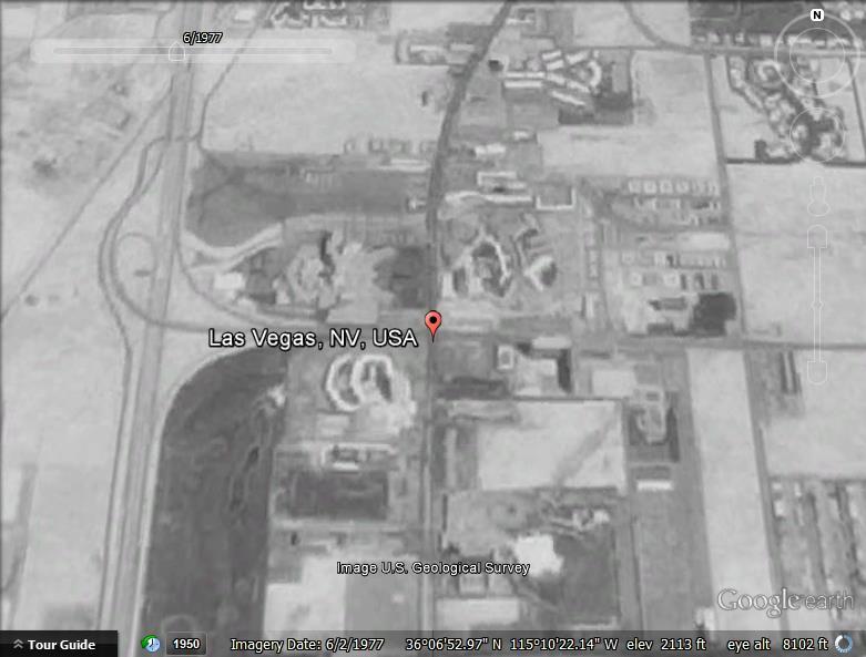
95 Module Outline Creating a viewshed Creating an elevation profile 95
96 Viewshed Basics GE Pro feature 360-degree view of area visible from a Placemark Doesn t limit the view to a particular angle Visible area highlighted in green; non-visible area shaded in gray 96

97 Viewshed Example 97
98 Viewshed Examples Architects can analyze the views available from a tract of land before designing buildings. Real estate agents can evaluate views remotely, and take views into consideration when they set property prices. Land developers can illustrate the viewable areas of parcels Businesses can make rough estimates of cell tower coverage from a particular location. Advertisers can try out different locations for billboards and signs. 98
99 How Viewshed Works Uses terrain layer to calculate Viewshed is calculated from Placemark view What you would see if you were at the Placemark itself, looking out at the view all around you This is the view that Viewshed calculates. Camera view View of the Placemark and its surroundings This is the view GE displays In other words, Earth Pro calculates the viewshed from the Placemark view and displays the viewshed from the Camera view. 99
100 Using Viewshed 1. Select an existing placemark or create a new one. 2. Right-click the placemark, then select Get Info. The Edit Placemark dialog appears. 3. Click Altitude and adjust the altitude so that it's at least approximately one meter above the surface, then click OK. 4. From either the Edit menu or the placemark s right-click menu, select Show Viewshed. 100
101 Exercise Please complete the following exercise: Defining a Viewshed for a Commercial Property 101

102 Elevation Profiles Explore elevations of a particular path Draw a new path or open an existing path Edit Show Elevation Profile Right click the path in Places panel and select Show Elevation Profile Y-axis displays elevation X-axis displays distance 102
103 Exercise Please complete the following exercise: Creating an Elevation Profile for a Path 103
104 USING HISTORICAL IMAGERY 104

105 Overview of Historical Imagery See how places have changed over time Some areas have imagery going back in time By default, GE displays the most recent imagery Click the Historical Imagery button to display the time slider Displays the oldest imagery available on left hand side of slider Small vertical lines indicate date when imagery is available Use tools provided to move back and forth in time 105
106 Overview of Historical Imagery Demonstration 106


107 1950 Historical Imagery Example Las Vegas


108 Historical Imagery Slider 108
Using Google Earth Pro
 Using Google Earth Pro (v7.3.2) University of Toronto Mississauga Library Hazel McCallion Academic Learning Centre October 2018 FURTHER ASSISTANCE If you have questions or need assistance contact Tanya
Google Earth. Tutorials. Tutorial 2: Annotating Google Earth
 Google Earth Tutorials Tutorial 2: Annotating Google Earth Google Earth makes it easy to create a map with annotations - you can add placemarks (points), paths (lines), polygons in Google Earth, and add
PlaceMap. Accommodation. Slide 1
 PlaceMap for Accommodation Slide 1 PlaceMap Using the power of Google Earth to store and display all of your spatial data in a much more dynamic way Google Earth is a free software program that lets you
Google Earth Pro: A tutorial
 Google Earth Pro: A tutorial 1 OVERVIEW As of early 2015, Google Earth Pro, which used to be a $400 product, is now free. This is a powerful yet simple tool for viewing information geographically whether
GIS Basics for Urban Studies
 GIS Basics for Urban Studies Date: March 21, 2018 Contacts: Mehdi Aminipouri, Graduate Peer GIS Faciliator, SFU Library (maminipo@sfu.ca) Keshav Mukunda, GIS & Map Librarian Librarian for Geography (kmukunda@sfu.ca)
Guide to Mapping Website (Public) December 2016 GC_236594
 December 2016 GC_236594") Guide to Mapping Website (Public) December 2016 GC_236594 Table of Contents Guide to Mapping Website (Public)... 1 December 2016... 1 Quick Start... 3 Map Layers... 4 How do I?... 5 Draw on the Map...
Guide to Mapping Website (Public) December 2016 GC_236594 Table of Contents Guide to Mapping Website (Public)... 1 December 2016... 1 Quick Start... 3 Map Layers... 4 How do I?... 5 Draw on the Map...
Using Google Earth. Middlebury College Library and Information Services
 Using Google Earth Middlebury College Introduction: While Google Earth can be a fun tool for simply looking at the surface of the earth, there are many other more sophisticated features to explore. Google
City of La Crosse Online Mapping Website Help Document
 City of La Crosse Online Mapping Website Help Document This document was created to assist in using the new City of La Crosse online mapping sites. When the website is first opened, a map showing the City
Google Earth Tutorial 1: The Basics of Map-making in Google Earth 6.2
 Google Earth Tutorial 1: The Basics of Map-making in Google Earth 6.2 University of Waterloo Map Library, 2012 Part 1: Placemarks 1. Locating a Geographical Area a. Open up Google Earth. b. In the Search
SAGIS Property Map Viewer Instruction Manual Instructions for using the SAGIS Property Map Viewer. Published December 21, 2018.
 SAGIS Property Map Viewer Instruction Manual www.sagis.org/map Instructions for using the SAGIS Property Map Viewer. Published December 21, 2018. 1 Instructional Videos Click on a link to watch a video
Google Earth an introduction
 Luana Valentini InternetGIS course - 2011 Google Earth an introduction Google Earth combines the power of Google Search with satellite imagery, maps, terrain and 3D buildings to put the world's geographic
Note: This tutorial was designed for Windows users. Applications DANA PORTER LIBRARY. February 19, 2013 Authored by: The Geospatial Centre
 Applications DANA PORTER LIBRARY February 19, 2013 Authored by: The Geospatial Centre 0 TABLE OF CONTENTS Google Earth Introduction... 2 Historical Imagery... 3 Objective... 3 Step by Step... 3 Ruler...
RAPIDMAP Geocortex HTML5 Viewer Manual
 RAPIDMAP Geocortex HTML5 Viewer Manual This site was developed using the evolving HTML5 web standard and should work in most modern browsers including IE, Safari, Chrome and Firefox. Even though it was
OnCOR Silverlight Viewer Guide
 Getting Around There are many ways to move around the map! The simplest option is to use your mouse in the map area. If you hold the left button down, then click and drag, you can pan the map to a new
Introduction to Google Earth Tutorial Haiti. 3/15/2011. Tufts GIS Center. Data Exploration
 Introduction to Google Earth Tutorial Haiti. 3/15/2011. Tufts GIS Center. Data Exploration 1. Open Google Earth 2. On the left you will see a navigation pane with 3 sections: Search, Places and Layers.
GSSHA WMS Basics Loading DEMs, Contour Options, Images, and Projection Systems
 v. 10.0 WMS 10.0 Tutorial GSSHA WMS Basics Loading DEMs, Contour Options, Images, and Projection Systems Learn how to work with DEMs and images and to convert between projection systems in the WMS interface
Juniata County, Pennsylvania
 GIS Parcel Viewer Web Mapping Application Functional Documentation June 21, 2017 Juniata County, Pennsylvania Presented by www.worldviewsolutions.com (804) 767-1870 (phone) (804) 545-0792 (fax) 115 South
Google Earth II: Create a tour with Google Earth
 Google Earth II: Create a tour with Google Earth This workshop is a continuation of The Google Earth Workshop I: Map-making Basics. You will create a tour to show the main and satellite campuses of the
An Introduction to Google Earth Pro
 An Introduction to Google Earth Pro Virginia Tech Geospatial Extension Program By: Katherine Britt Ph.D. Candidate Virginia Tech Department of Forest Resources and Environmental Conservation John McGee
Overview. Setting Up. Geospatial Centre University of Waterloo May 2014
 Overview ArcGIS Online is a web-based mapping and app-building site created by Esri, the world leader in GIS software. In an effort to empower users of all levels to create interactive maps and applications
Introduction to Google Earth
 Introduction to Google Earth Assignment: The goal of this assignment is for you to become familiar with Google Earth. You may work alone or with a partner but you must turn in your own individual work.
To show toolbars, double-click in the banner at the top or click the tools icon
 8/15/2013 Welcome to Culver City s GIS Property Information Search 2.0. This instructional document provides an overview of most commonly used functionality in this streamlined, enhanced web map application.
Greater Bridgeport Regional Council Municipal GIS Viewer Training April 2015
 Greater Bridgeport Regional Council Municipal GIS Viewer Training April 2015 GBRC GIS Web Training Table of Contents Introduction........................................................... 3 Viewer Components.......................................................
Overview of ArcGIS Online Applications. Champaign County
 Overview of ArcGIS Online Applications Champaign County Champaign County GIS Consortium Updated: April 2017 Table of Contents ArcGIS Online Application Overview... 3 Map Interface Symbology and Terminology...
Explore some of the new functionality in ArcMap 10
 Explore some of the new functionality in ArcMap 10 Scenario In this exercise, imagine you are a GIS analyst working for Old Dominion University. Construction will begin shortly on renovation of the new
TerraExplorer Quick Start Guide
 TerraExplorer Quick Start Guide Basic Concepts Opening, Creating, and Saving.. 1 Navigating in the 3D Window... 1 Using the Project Tree... 2 System Requirements... 2 Project Settings Controlling Date
REDI 5.0 User Manual
 REDI 5.0 User Manual OBJECTIVE: REDI (Regional Economic Development Information System) provides a quick, convenient and easy way of accessing the City of San Diego Business Incentive Zones (BIZ) information.
FrontCounter BC Discovery Tool Instructions. NOTE: You must have Google Earth installed to use this tool.
 NOTE: You must have Google Earth installed to use this tool. These instructions are written for use with a Microsoft Windows Work Station. This tutorial will step you through navigating to and viewing
US Geo-Explorer User s Guide. Web:
 US Geo-Explorer User s Guide Web: http://usgeoexplorer.org Updated on October 26, 2016 TABLE OF CONTENTS Introduction... 3 1. System Interface... 5 2. Administrative Unit... 7 2.1 Region Selection... 7
Full Search Map Tab Overview
 FlexMLS Map Server Full Search Map Tab Overview The Full Search Map tab is a need to know module. It is accessible when you use Full Search under Search in the Main Menu tree of FlexMLS. This map can
Geographical Information Systems Institute. Center for Geographic Analysis, Harvard University. LAB EXERCISE 1: Basic Mapping in ArcMap
 Harvard University Introduction to ArcMap Geographical Information Systems Institute Center for Geographic Analysis, Harvard University LAB EXERCISE 1: Basic Mapping in ArcMap Individual files (lab instructions,
Page 1 of 16 CONTENTS:
 Page 1 of 16 CONTENTS: HOME-BOX -- (PG.2) o PROPERTY OWNERSHIP o ADDRESS SEARCH o I WANT TO AERIAL IMAGERY AND BASE MAPS -- (PG.2) o IMAGERY WITH LABELS ON/OFF o TOPOGRAPHY ON/OFF o TRANSPARENCY ZOOM IN
Map Library ArcView Version 1 02/20/03 Page 1 of 12. ArcView GIS
 Map Library ArcView Version 1 02/20/03 Page 1 of 12 1. Introduction 1 ArcView GIS ArcView is the most popular desktop GIS analysis and map presentation software package.. With ArcView GIS you can create
Press the Plus + key to zoom in. Press the Minus - key to zoom out. Scroll the mouse wheel away from you to zoom in; towards you to zoom out.
 Navigate Around the Map Interactive maps provide many choices for displaying information, searching for more details, and moving around the map. Most navigation uses the mouse, but at times you may also
COPYRIGHTED MATERIAL. Introduction to 3D Data: Modeling with ArcGIS 3D Analyst and Google Earth CHAPTER 1
 CHAPTER 1 Introduction to 3D Data: Modeling with ArcGIS 3D Analyst and Google Earth Introduction to 3D Data is a self - study tutorial workbook that teaches you how to create data and maps with ESRI s
Server Usage & Third-Party Viewers
 Server Usage & Third-Party Viewers October 2016 HiPER LOOK Version 1.4.16.0 Copyright 2015 PIXIA Corp. All Rights Reserved. Table of Contents HiPER LOOK Server Introduction... 2 Google Earth... 2 Installation...2
Chapter 7. A Quick Tour of ArcGIS Pro
 Chapter 7 A Quick Tour of ArcGIS Pro Skills you will learn: This tutorial is intended to get you going using ArcGIS Pro, a new desktop application that is part of ArcGIS Desktop. A separate tutorial gives
ArcMap and Google Earth
 ArcMap and Google Earth Prepared by Andrew Hobby CVEN 658 November 25, 2008 Contents: Brief Overview of Google Earth Goals of Exercise Computer and Data Requirements Procedure: 1. Creating a KML File 2.
NEW LOOK OF RAPIDMAP! Below is how the RapidMap interface will look when it is initially opened.
 NEW LOOK OF RAPIDMAP! Below is how the RapidMap interface will look when it is initially opened. MAP LAYERS When the arrow to the left of the Search For button is clicked, a Map Layers panel will slide
Chapter 1 : Getting Started with Integrity... Chapter 2 : Interface Layout... Chapter 3 : Navigation... Chapter 4 : Printing...
 .0 User s Manual Table of Contents Chapter : Getting Started with Integrity... Chapter : Interface Layout... Chapter : Navigation... Chapter : Printing... Chapter : Quick Search and Results Pane... Results
NAACCR Webinar Exercises. May 6, 2010 Kevin Henry Francis Boscoe
 NAACCR Webinar Exercises May 6, 2010 Kevin Henry Francis Boscoe EXERCISE 1 Google Earth and Geocoding Individual Cases Part 1 Introduction to Google Earth 1 Open Google Earth Click Start Programs Google
ATNS. USING Google EARTH. Version 1
 ATNS USING Google EARTH Version 1 ATNS/HO/Using Google Earth Page 1 25/04/2013 CONTENTS 1. BASIC SETUP 2. NAVIGATING IN GOOGLE EARTH 3. ADDING OBJECTS TO GOOGLE EARTH 4. USER HELP REFERENCES ATNS/HO/Using
Working with Google Earth
 Working with Google Earth The Places panel in Google Earth serves as a repository to bookmark locations that you want easy access to. There are two folders located in Places: My Places and Temporary Places.
Greenville County Internet Mapping System User s Guide
 Greenville County Internet Mapping System User s Guide Version 2.0 Greenville County Geographic Information Systems May 30, 2006 Table of Contents NAVIGATING TO THE ONLINE MAPPING APPLICATIONS...- 3 -
COMMISSION OF TEXAS MAY
 GIS Viewer RAILROAD COMMISSION OF TEXAS MAY 2017 Table of Contents GIS Viewer Basics... 1 Basics... 1 Screen Overview... 2 Tools... 5 Visibility... 5 Measure Tool... 7 Identify Tool... 10 Coordinates Tool...
QGIS Workshop Su Zhang and Laura Gleasner 11/15/2018. QGIS Workshop
 1. Introduction to QGIS QGIS Workshop QGIS is a free and open source Geographic Information System (GIS). QGIS can help users create, edit, visualize, analyze, and publish geospatial information on various
Data to App: Web,Tablet and Smart Phone Duane Griffith, Montana State University,
 Data to App: Web,Tablet and Smart Phone Duane Griffith, Montana State University, griffith@montana.edu This tutorial is broken into several steps related mostly to the technology applied at each step.
Viewer Features. DataBC Mashup Framework (DMF)
") Viewer Features DataBC Mashup Framework (DMF) Copyright 2014 Ministry of Labour, Citizens' Services and Open Government All Rights Reserved. Printed in Canada The information contained in this document
Viewer Features DataBC Mashup Framework (DMF) Copyright 2014 Ministry of Labour, Citizens' Services and Open Government All Rights Reserved. Printed in Canada The information contained in this document
Google Earth Maps. Creating an Outdoor Location Using Google Earth. Understanding Geographical Coordinates for Google Earth CHAPTER
 CHAPTER 18 Within Monitor >, you can create an outdoor location, import a file, view Google Earth maps, and specify Google Earth settings. Creating an Outdoor Location Using Google Earth Importing a File
How to use the DuPage County Parcel Viewer Interactive Web Mapping Application.
 How to use the DuPage County Parcel Viewer Interactive Web Mapping Application. Parcel Viewer URL: URL: http://gis.dupageco.org/parcelviewer/ Initial View (And frequently asked questions) Parcel Search
Introduction to Social Explorer
 Introduction to Social Explorer Janine Billadello, Geospatial Data Lab, Baruch College October 1, 2015 Abstract This tutorial will introduce you to Social Explorer, an online mapping interface that allows
Excel To KML - Display Excel files on Google Earth.
 Page 1 of 6 Earth Point Real Estate Home Introduction Q & A County Records Property Search County GIS Utilities Township & Range Excel To KML Around Town Press Blog About Local Homes, Global View Home
To the GeoView System Overview Online Training Course
 Welcome! To the GeoView System Overview Online Training Course The Alberta Department of Energy provides GeoView as a mapping system to enable users to find geographic information in Alberta. GeoView retrieves
Peoria County Front Desk Map Application
 Peoria County Front Desk Map Application Quick Guide, 2017 At a First Glance This guide will tell users all they need to know about the Peoria County Front Desk application which can be found on the Peoria
Mobile ArcGIS maps, offline. CarryMap for ArcGIS Version: Data East, LLC
 Mobile ArcGIS maps, offline. CarryMap for ArcGIS Version: 3.13 2008-2016 Data East, LLC About CarryMap Data East CarryMap is an extension to ArcGIS for Desktop provided for creating mobile offline maps
An Introduction to Geographic Information Systems (GIS) using ArcGIS 9.2
 using ArcGIS 9.2") An Introduction to Geographic Information Systems (GIS) using ArcGIS 9.2 by Marcel Fortin, GIS and Map Librarian, University of Toronto Libraries, 2009 gis.maps@utoronto.ca http://www.library.utoronto.ca/maplib/
An Introduction to Geographic Information Systems (GIS) using ArcGIS 9.2 by Marcel Fortin, GIS and Map Librarian, University of Toronto Libraries, 2009 gis.maps@utoronto.ca http://www.library.utoronto.ca/maplib/
Getting Started with VicMap
 Getting Started with VicMap This is a brief overview of some of the tools and features available on VicMap. At any time you can right click on the map and click Identify What s Here to find more information
2. The flight across the globe will begin and your final destination will be your home.
 Google Earth 5.0 The Google Earth interface has a toolbar across the top and a panel down the left side. On the left panel, there are three sections: Search, Places and Layers. 1. In the Search section,
Georeferencing Tutorials and Recommended Practices
 March 21, 2008 Georeferencing Tutorials and Recommended Practices Topic Page Introduction 1 Preparing address data for georefernecing 1 Available address geocoders, pros and cons 1 Using Batchgeocode.com
Introduction to Programming the Google Maps API
 Introduction to Programming the Google Maps API E-Learning for the GIS Professional Any Time, Any Place! geospatialtraining.com Course Modules Module 1: Introduction to Programming the Google Maps API
Georeferencing and Digitizing
 INTRODUCTION There is a great deal of geographic data available in formats that cannot be immediately integrated with other GIS data. In order to use these types of data in GIS it is necessary to align
Full Search Map Tab. This map is the result of selecting the Map tab within Full Search.
 Full Search Map Tab This map is the result of selecting the Map tab within Full Search. This map can be used when defining your parameters starting from a Full Search. Once you have entered your desired
Geocoding Reference USA data in ArcMap 9.3
 Tufts GIS Tip Sheet Geocoding Reference USA data in ArcMap 9.3 Written by Barbara Parmenter Revised 3/1/2011 In this exercise, you will map businesses or services for a town in the Boston metropolitan
_Tutorials. Arcmap. Linking additional files outside from Geodata
 _Tutorials Arcmap Linking additional files outside from Geodata 2017 Sourcing the Data (Option 1): Extracting Data from Auckland Council GIS P1 First you want to get onto the Auckland Council GIS website
Secure Zoo Strategy Biosecurity Mapping Tool. Instructional Guide
 Secure Zoo Strategy Biosecurity Mapping Tool Instructional Guide Table of Contents Introduction Acronyms & Abbreviations Materials Section 1: Data Definitions and Symbology o Definitions o Symbology Section
Introduction to using QGIS for Archaeology and History Workshop by the Empirical Reasoning Center
 Introduction to using QGIS for Archaeology and History Workshop by the Empirical Reasoning Center In this workshop, we will cover the basics of working with spatial data, as well as its main uses for archaeology.
Open Source Cloud Map User Guide
 Open Source Cloud Map User Guide Table of Contents Map Page... 1 Static Mercator Map... 1 Customizable Map... 1 Title Bar... 2 Toolbar... 2 Non Toolbar Navigation... 3 Map Window... 3 Layers / Legend Window...
I. An Intro to ArcMap Version 9.3 and 10. 1) Arc Map is basically a build your own Google map
 Arc Map is basically a build your own Google map") I. An Intro to ArcMap Version 9.3 and 10 What is Arc Map? 1) Arc Map is basically a build your own Google map a. Display and manage geo-spatial data (maps, images, points that have a geographic location)
I. An Intro to ArcMap Version 9.3 and 10 What is Arc Map? 1) Arc Map is basically a build your own Google map a. Display and manage geo-spatial data (maps, images, points that have a geographic location)
Geodatabases. Dr. Zhang SPRING 2016 GISC /03/2016
 Geodatabases Dr. Zhang SPRING 2016 GISC 1401 10/03/2016 Using and making maps Navigating GIS maps Map design Working with spatial data Spatial data infrastructure Interactive maps Map Animations Map layouts
Development Authority of the North Country (DANC) Internet Mapping Application Instructions Public Viewer 1. Purpose. 2. Logging-in. 3.
 Internet Mapping Application Instructions Public Viewer 1. Purpose. 2. Logging-in. 3.") Development Authority of the North Country (DANC) Internet Mapping Application Instructions Public Viewer 1. Purpose The purpose of this document is to outline basic functionality of the DANC Internet
Development Authority of the North Country (DANC) Internet Mapping Application Instructions Public Viewer 1. Purpose The purpose of this document is to outline basic functionality of the DANC Internet
PWC County Mapper XM User Instruction (AS OF 12/03/2009)
") PWC County Mapper XM User Instruction (AS OF 12/03/2009) MAP NAVIGATION There are several ways to navigate the map, you can use your keyboard/mouse combination, use the Navigation toolbar, use the slider
PWC County Mapper XM User Instruction (AS OF 12/03/2009) MAP NAVIGATION There are several ways to navigate the map, you can use your keyboard/mouse combination, use the Navigation toolbar, use the slider
City of Richmond Interactive Map (RIM) User Guide for the Public
 User Guide for the Public") Interactive Map (RIM) User Guide for the Public Date: March 26, 2013 Version: 1.0 3479477 3479477 Table of Contents Table of Contents Table of Contents... i About this
Interactive Map (RIM) User Guide for the Public Date: March 26, 2013 Version: 1.0 3479477 3479477 Table of Contents Table of Contents Table of Contents... i About this
Introduction to the Google Earth Engine Workshop
 Introduction to the Google Earth Engine Workshop This workshop will introduce the user to the Graphical User Interface (GUI) version of the Google Earth Engine. It assumes the user has a basic understanding
Carlson GIS for Surveyors
 Professional Land Surveyors of Ohio 2016 Annual Conference -- Dayton Ohio Carlson GIS for Surveyors Presented by Who Is That CAD Girl? Jennifer DiBona is a long time CAD consultant and trainer doing business
MAKING MAPS WITH GOOGLE FUSION TABLES. (Data for this tutorial at
 MAKING MAPS WITH GOOGLE FUSION TABLES (Data for this tutorial at www.peteraldhous.com/data) Thanks to Google Fusion Tables, creating maps from data and embedding them on a web page is now easy. We re going
Viewing the Data 3 Turning Layers On / Off 4 Navigation Toolbar 5 Layout Toolbar 7 Identify Tool 8 Find Tool 10 Measure Tool 12 Go To XY Tool 14
 1 Viewing the Data 3 Turning Layers On / Off 4 Navigation Toolbar 5 Layout Toolbar 7 Identify Tool 8 Find Tool 10 Measure Tool 12 Go To XY Tool 14 Transparency Tool 16 Markup Tools 19 ArcMap Markup Tools
Create Geomark in Google Earth Tutorial
 Create Geomark in Google Earth Tutorial General business example a potential applicant / user wants to create an area of interest that can be shared electronically to another party eg: another agency,
v SMS Tutorials Working with Rasters Prerequisites Requirements Time Objectives
 v. 12.2 SMS 12.2 Tutorial Objectives Learn how to import a Raster, view elevations at individual points, change display options for multiple views of the data, show the 2D profile plots, and interpolate
MANITOBA LAND USE AND DEVELOPMENT WEB APPLICATION: How-to guide and help document
 MANITOBA LAND USE AND DEVELOPMENT WEB APPLICATION: How-to guide and help document 2 Index Index... 2 Layout & View... 3 Overview... 3 Layers... 4 Municipal Relations Data Layers... 4 Application Toolbar...
ArcGIS Explorer Workshop. Bern Szukalski ESRI Redlands, California
 ArcGIS Explorer Workshop Bern Szukalski bszukalski@esri.com Redlands, California What is ArcGIS Explorer? A free, lightweight, easy to use desktop application that can access, integrate, and utilize GIS
Address Management User Guide. PowerSchool 8.x Student Information System
 PowerSchool 8.x Student Information System Released July 2014 Document Owner: Documentation Services This edition applies to Release 8.0.1 of the PowerSchool software and to all subsequent releases and
Objectives Learn how to work with projections in WMS, and how to combine data from different coordinate systems into the same WMS project.
 s v. 11.0 Projections / Coordinate Systems WMS 11.0 Tutorial Projections / Coordinate Systems Working with map projections in WMS Objectives Learn how to work with projections in WMS, and how to combine
University of North Dakota PeopleSoft Finance Tip Sheets. Utilizing the Query Download Feature
 There is a custom feature available in Query Viewer that allows files to be created from queries and copied to a user s PC. This feature doesn t have the same size limitations as running a query to HTML
SAVI Advanced The Basics
 SAVI Advanced The Basics Help Topics The Basics Getting Started System Requirements Getting Started Using SAVI Advanced Exploring the Data in SAVI Advanced Viewing Change Over Time Identifying Target Geographies
Setting up a 3D Environment for the City of Portland
 Setting up a 3D Environment for the City of Portland www.learn.arcgis.com 380 New York Street Redlands, California 92373 8100 USA Copyright 2018 Esri All rights reserved. Printed in the United States of
Pre-release User Guide. Version 2.0 August 2015
 Pre-release User Guide Version 2.0 August 2015 Copyright 2015 EagleView Technologies. Copyright 2015 Pictometry International Corp. All rights reserved. No part of this publication may be reproduced, stored
Objectives Learn how to work with projections in SMS, and how to combine data from different coordinate systems into the same SMS project.
 v. 12.2 SMS 12.2 Tutorial Working with map projections in SMS Objectives Learn how to work with projections in SMS, and how to combine data from different coordinate systems into the same SMS project.
New Mexico Watch: User Guide
 New Mexico Watch: User Guide The New Mexico Watch (nmwatch.org) interactive website distributes maps, data, and related information of natural disasters within New Mexico. This application is developed
COGCC GIS Online Map Instructions - Internet Site April 10, 2018
 COGCC GIS Online Map Instructions - Internet Site April 10, 2018 Table of Contents Page Section Page Section 1 Introduction 8 Clear Selection 2 Double Click 8 Buffer 3 Arrow Tip Information 9 Select within
Overview of SAS/GIS Software
 3 CHAPTER 1 Overview of SAS/GIS Software Introduction to Geographic Information Systems 3 Features of SAS Software 4 Data in SAS/GIS Applications 5 Spatial Data 5 Spatial Data Layers 6 Spatial Data Coverages
Version 6 Release Notes
 Version 6 Release Notes Information contained in this document is subject to change without notice and does not represent a commitment on behalf of Skyline Software Systems Inc. No part of this document
Objectives Learn how to work with projections in SMS, and how to combine data from different coordinate systems into the same SMS project.
 v. 12.3 SMS 12.3 Tutorial Working with map projections in SMS Objectives Learn how to work with projections in SMS, and how to combine data from different coordinate systems into the same SMS project.
Waushara County Public Access Land Records Viewer Help
 Waushara County Public Access Land Records Viewer Help Main Screen Layout Overview Zoom Pan Controls Parcel Tools Tools Help and Links Image Layers Transition Tools Search Results from Parcel Search Tool
FAQ & Troubleshooting
 FAQ & Troubleshooting What is the most common issue users have when using the site? Pop-Up Blocker!!! Any link external to the viewer requires a new window to be opened in the browser. See My map or report
Help Documentation. Copyright 2007 WebAssist.com Corporation All rights reserved.
 Help Documentation Copyright 2007 WebAssist.com Corporation All rights reserved. Using Pro Maps for Google This wizard adds a Pro Map for Google to your web page, allowing you to configure and specify
About...1. Quick Start...2. Features and options...3. Thematic Map...3. Indicators Panel Graph Panel Options Panel...
 USER GUIDE TABLE OF CONTENTS About...1 Quick Start...2 Features and options...3 Thematic Map...3 Indicators Panel... 5 Graph Panel... 6 Options Panel... 7 Data-table Panel... 8 Selection Panel... 8 Time
APPENDIX G. VMT Spreadsheet Tool. FINAL REPORT Improved Data & Tools for Integrated Land Use-Transportation Planning in California TOPICS:
 FINAL REPORT Improved Data & Tools for Integrated Land Use-Transportation Planning in California APPENDIX G VMT Spreadsheet Tool TOPICS: 1. Overview of Tool 2. Code Documentation 3. User Guide 4. Validation
Chapter 6. Building Maps with ArcGIS Online
 Chapter 6 Building Maps with ArcGIS Online Summary: ArcGIS Online is an on-line mapping software that allows you to upload tables with latitude and longitude geographic coordinates to create map layers
Google Earth for Genealogy October 15, 2016 Heritage Hunters of Saratoga County
 Google Earth for Genealogy October 15, 2016 Heritage Hunters of Saratoga County http://www.saratoganygenweb.com/gwsarhh.html Dennis A. Hogan, http:// This Complete Presentation is available online At,
FlexMLS Maps Quick Reference Guide
 FlexMLS Maps Quick Reference Guide Full Search Map Tab Features Define Search Areas box Map tab in Full Search Radius Search tool from an address Show/Hide Property List, Locate Address, and Define Search