Integrated Modeling Overview: OpenMI and EMIT. Anthony Castronova Utah State University
|
|
|
- Gerald Page
- 5 years ago
- Views:
Transcription
1 Integrated Modeling Overview: OpenMI and EMIT Anthony Castronova Utah State University
2 OpenMI Overview and Applications

3 Model Integration 9/1/2015 3
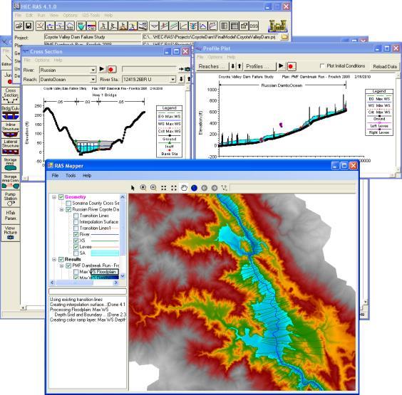
4 Tight Integration Bound by source code Enables complete control over integrated modeling system Can be optimized for performance Requires a great deal of expertise Source code must be available Requires customized integration for every model system Coupler HEC-RAS MODFLOW Model.exe 9/1/2015 4
5 Loose Integration 9/1/2015 5
, Wallingford Software (Innovyze) Concepts")
 Variable, Unit, Element Set")
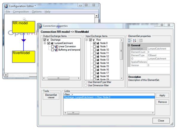
6 Open Modeling Interface Software Interfaces for Component Modeling EU Water Framework Directive C#, Java DHI, Delft (Deltares), Wallingford Software (Innovyze) Concepts Timestep data transfer (pull-based) Ask for what you want, get what you asked for Data Representation Exchange Items (what is it, where is it) Variable, Unit, Element Set (geometric data)

7 OpenMI Timeline 2007 OpenMI 1.4 C#, Java standard interfaces C# development API 2010 OpenMI 2.0 C#, Java standard interfaces C# development API more flexible component linking and control flow, enhanced data values support 2011/2012 FluidEarth Graphical user interface for building coupled models Software developers from many difference commercial modeling companies Professional software development Limited time


8 The OpenMI Standard Concepts Ground Water River Rainfall Runoff 9/1/2015 8
9 Simulation Control
10 Advantages Collaboration and cross-disciplinary studies Large problems that can not be explored by stand alone models. Predict the wider implications of policies and projects Modular development Simplifies model substitution Helpful when changing spatial scales, and performing uncertainty or sensitivity analyses Reduces Model creep Model and source reuse Eliminate the need to redevelop models Cross-disciplinary model development Community Adoption Simple Model Wrapper Simple Script Wrapper PyOpenMI HydroCouple 9/1/
11 EX1: Integrate OpenMI with Existing Architecture 1. Establish a method for mapping data between the OpenMI and HIS 1. Conceptual mapping 2. Metadata mapping 3. Observations vs Model computations 2. Build integrated modeling environment 1. Leverage data mapping 2. Build from of the OpenMI standard 3. Dedicated components for reading and writing data to and from ODM databases 3. Construct some models to leverage new tech. 1. Urban Watershed configuration 2. ET configuration (dominated by observations) 3. Rural watershed configuration 9/1/

12 CUAHSI HIS Consortium of Universities for the Advancement of Hydrologic Science, Inc. Hydrologic Information System Collaborative effort University of Texas, Austin Utah State University San Diego Super Computing Center Idaho State University City College of New York University of South Carolina NSF Funded ($4.7 Million ) Goals Make the nation's water information universally accessible and useful Provide access to data sources, tools and models Enable the synthesis, visualization and evaluation of the behavior of hydrologic systems. 9/1/

13 Hydrologic Information System (HIS) Web service network of hydrologic resources Enables users to publish data Searching across distributed HIS data Opensource GIS Entry point to the HIS observation data Extendable through plugin development 9/1/

14 Observations Data Model (1.1)
15 Data Mapping Hydrologic Information System Formal representation of observations data Comprehensive metadata Considers only point geometries Open Modeling Interface Standard for describing model data Transferring and sharing of data More general 9/1/

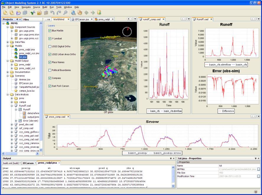
16 HydroModeler Component modeling plugin for the HydroDesktop Extends the original OpenMI configuration editor (OmiED) Provides a more extensible modeling environment Built on OpenMI /1/
17 Model Configuration for ET 9/1/

18 ET Results 9/1/

19 Coweeta Watershed TOPModel Located in western NC Long Term Ecological Research Watershed 18, 0.12 km 2 Readily available observations EX2: Service Orientation 9/1/
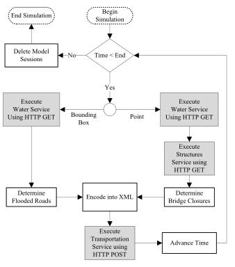
20 Modeling Web using REST/ OGC Web Processing Service Models exposed as services using the Open Geospatial Consortium (OGC) Web Processing Service (WPS) standard. Get Capabilities gives metadata about models on server Describe Process gives metadata about a specific model service Execute is more complex that a typical WPS to support model time stepping (e.g., session state with users must be maintained)

21 Simulation and Results GET DbReader Supplies CUAHSI HIS observation data Hargreaves Calculates PET using temperature data. Wps:Topmodel Wraps the web TOPMODEL web resource into an OpenMIcompliant form 9/1/


22 EX3: Urban Infrastructure Downtown Columbia floods often Property damage Infrastructure damage Short, high intensity storms 2.26 in 1 hour River depth from 10in to 10.74ft in 1 hour


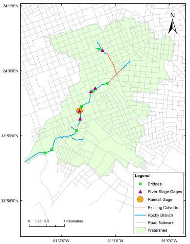
23 Model Design 9/1/

24 Simulation Results
25 Lessons Learned OpenMI was used to provide runtime interaction between OpenMI and HIS DbReader can seamlessly extract observation data during a simulation DbWriter automatically writes model data back to the HIS repository This approach was successfully extended using web services OpenMI concepts are transferrable beyond their original use cases Provide acceptable description of model input and outputs. Platform dependence Becoming more important as more scientists are using Linux and OSX. C# is not a scientist friendly language (high learning curve, not taught to civil graduate students) OpenMI core development efforts Limited development time results in lengthily gaps between releases Releases 1.4 and 2.0 have significant differences Lack of sufficient GUI (OmiED, Pipistrelle, FluidEarth) 9/1/
26 iutah Coupled Modeling


27 iutah: innovative Urban Transitions and Aridregion Hydro-sustainability Statewide effort $20 million competitive award from NSF EPSCoR Research capacity building Interdisciplinary and multiinstitution Focused on sustainable management of Utah s water resources Courtesy of Amber Spackman-Jones


28 iutah Research Focus Areas 1. Eco-hydrology Expand Utah s capacity in the natural sciences through instrumentation of 3 watersheds. 2. Social and Engineered Water Systems Studying demographic characteristics, water use behaviors, water infrastructure, and other measures of urban form. 1. Interdisciplinary Modeling and Visualization Development of interdisciplinary models of socio-ecohydrological systems to determine how changes in water availability and use alter water quantity and quality. Courtesy of Amber Spackman-Jones


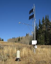
29 Gradients Along Mountain to Urban Transitions (GAMUT) Network Ecohydrologic observatory deployed in 3 watersheds in northern Utah, USA: Logan River, Red Butte Creek, Provo River Watersheds with similar water source (high elevation snow) but different land use transitions Measures aspects of water inputs and outputs and water quality over mountain-to-urban gradient Mix of aquatic and terrestrial in situ and relocatable sensors Courtesy of Amber Spackman-Jones


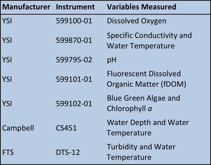
30 Gradients Along Mountain to Urban Transitions (GAMUT) Network Climate/Terrestrial Sites Aquatic Sites Courtesy of Amber Spackman-Jones


31 The Data Deluge One year = One 35,040 day week month observations = 96 = observations So far (~1.5 observations years) = 55,000+ observations Times 14 Aquatic Sites with ~26 Variables Times 14 Climate Sites with ~74 Variables Plus different versions of the data = 43,400,000+ observations We Want To Use This Data! Courtesy of Amber Spackman-Jones

32 GAMUT Data Workflow


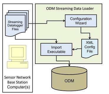

33 Data Movement and Storage ODM


34 Framework Design Considerations Diverse scientific needs Hydrology, climate science, agriculture, city planning, green infrastructure, etc. Community engagement Needs to be easy to implement Supports various platforms Data ingestion Massive amount of data Seamless transfer of data into models Data Centric


35 Data Centricity Red Butte ODM Database Logan ODM Database Provo ODM Database ODM Version 2
36 Conceptual Model Components Source or executable wrapped with standard interfaces Configurations Linked arrangement of components. Links defining the transfer of data Storm Water Management Model Simulations Executed configurations and their results Coordination Central data coordinator Execution of models and transfer of data
37 Conceptual Model Components Source or executable wrapped with standard interfaces Observation Data Configurations Linked arrangement of components. Links defining the transfer of data Simulations Executed configurations and their results Energy Balance and Snowmelt Coordination Central data coordinator Execution of models and transfer of data Storm Water Management Model
38 Conceptual Model Components Source or executable wrapped with standard interfaces Observation Data Configurations Linked arrangement of components. Links defining the transfer of data Simulations Executed configurations and their results Energy Balance and Snowmelt Coordination Central data coordinator Execution of models and transfer of data Storm Water Management Model

39 Conceptual Model Components Source or executable wrapped with standard interfaces THREDD S GAMUT National Weather Data Configurations Linked arrangement of components. Links defining the transfer of data Coordination logic Simulations Executed configurations and their results Coordination Central data coordinator Execution of models and transfer of data
40 Data Flow Mechanisms Feed Forward Sequentially executed Data passed in a single direction Data Models, closed source software [ 0.14, 0.69, 0.90,...,] [ 0.49, 0.16, 0.70,...,] [ 0.66, 0.40, 0.53,...] [...] [...] Time Stepping Models advancing in time together Resolving boundary conditions Looping (Hybrid) Pushing loop Data / Feed models will not execute, but still pass data along at requested times [ 0.55, 0.90, 0.01,...,] [ 0.12, 0.60, 0.07,...,] [ 0.60, 0.04, 0.39,...] [...] [...] [ 1.55, 1.90, 1.01, 1.12, 1.60, 1.07, 1.60, 1.04, 1.39,...]
41 Workflow Mechanisms Feed Forward Sequentially executed Data passed in a single direction Data Models, closed source software [ 0.14, 0.69, 0.90,...,] [ 0.49, 0.16, 0.70,...,] [ 0.66, 0.40, 0.53,...] [...] [...] Time Stepping Models advancing in time together Resolving boundary conditions Looping (Hybrid) Pushing loop Data / Feed models will not execute, but still pass data along at requested times [ 0.55, 0.90, 0.01,...,] [ 0.12, 0.60, 0.07,...,] [ 0.60, 0.04, 0.39,...] [...] [...] [ 1.55, 1.90, 1.01, 1.12, 1.60, 1.07, 1.60, 1.04, 1.39,...]
42 Workflow Mechanisms Feed Forward Sequentially executed Data passed in a single direction Data Models, closed source software Time Stepping Models advancing in time together Resolving boundary conditions [ 0.14, 0.69, 0.90,...,] [ 0.49, 0.16, 0.70,...,] [ 0.66, 0.40, 0.53,...] [...] [...] [ 0.55, 0.90, 0.01,...,] [ 0.12, 0.60, 0.07,...,] [ 0.60, 0.04, 0.39,...] [...] [...] Looping (Hybrid) Pushing loop Data / Feed models will not execute, but still pass data along at requested times [ 1.55, 1.90, 1.01, 1.12, 1.60, 1.07, 1.60, 1.04, 1.39,...]
43 Goals 1. Extend existing coupled modeling architectures to engage a broad audience of modelers. 2. Design software wrappers to facilitate the transfer and ingestion of data between models in a generic manner. 3. Develop code that does not obstruct the functionality of legacy and newly developed software models. 4. Automatic transformation of temporally and spatially misaligned data between coupled models during simulations. 5. Access to environmental data (e.g. GAMUT) and server-side simulation results (e.g. NetCDF). 6. Develop a method to track model data provenance. 7. Maintain platform independent software to appeal to a diverse audience of modelers and models.


44
45 Modeling on an Open Platform o FOSS Libraries o FOSS Codebase Features Integration of Legacy Code o Operate on Windows, Linux, Mac o Language Interoperability o C, C++, Fortran, Python Data Transformations o Temporal misalignment o Spatial misalignment Simulation Workflow o Loop Driven (timestepping push control) Investigates how data can be passed to and from databases during simulation o Remotely stored data o Large datasets o Long term data archival o Complete record of all simulation results o Comprehensive data model for simulation archival

46 Data Storage
47 Where are we going? Next few months All GAMUT data will be made available for use in models Results storage in local SQLite database. Complete integration of NetCDF/HD5 datasets Within the next year SWMM, urban watershed model TOPMODEL, topographically-based watershed model TOPKAPI, fully distributed extension of TOPMODEL UEB, Utah Energy Balance Model WRF-Hydro, Climate simulation data via THREDDS/OpenDAP PIHM, finite volume hydrologic model WEAP, Water Evaluation And Planning SLEUTH, Land Change Model NetLogo, multi-agent programmable modeling environment.

48 Anthony Castronova Research Assistant Professor Utah State University
Models as web services using the Open Geospatial Consortium (OGC) Web Processing Service (WPS) standard
 Web Processing Service (WPS) standard") Models as web services using the Open Geospatial Consortium (OGC) Web Processing Service (WPS) standard Anthony M. Castronova a, Jonathan L. Goodall b,, Mostafa M. Elag c a Postdoctoral Researcher, Department
Models as web services using the Open Geospatial Consortium (OGC) Web Processing Service (WPS) standard Anthony M. Castronova a, Jonathan L. Goodall b,, Mostafa M. Elag c a Postdoctoral Researcher, Department
Jeffery S. Horsburgh. Utah Water Research Laboratory Utah State University
 Advancing a Services Oriented Architecture for Sharing Hydrologic Data Jeffery S. Horsburgh Utah Water Research Laboratory Utah State University D.G. Tarboton, D.R. Maidment, I. Zaslavsky, D.P. Ames, J.L.
Data Interoperability in the Hydrologic Sciences
 Data Interoperability in the Hydrologic Sciences The CUAHSI Hydrologic Information System David G Tarboton 1, David Maidment 2, Ilya Zaslavsky 3, Dan Ames 4, Jon Goodall 5, Richard P Hooper 6, Jeff Horsburgh
Universities Access IBM/Google Cloud Compute Cluster for NSF-Funded Research
 CollabrATEC ATEC 6351.002 Research and Design Home Archive Assignments Environment Ideas Interface Presentation Technology Narrative Search Universities Access IBM/Google Cloud Compute Cluster for NSF-Funded
Environmental Modelling: Crossing Scales and Domains. Bert Jagers
 Environmental Modelling: Crossing Scales and Domains Bert Jagers 3 rd Workshop on Coupling Technologies for Earth System Models Manchester, April 20-22, 2015 https://www.earthsystemcog.org/projects/cw2015
CUAHSI HYDROLOGIC INFORMATION SYSTEM 2010 STATUS REPORT
 CUAHSI HYDROLOGIC INFORMATION SYSTEM 2010 STATUS REPORT David G. Tarboton 1, David Maidment 2, Ilya Zaslavsky 3, Daniel P. Ames 4, Jon Goodall 5, Jeffery S. Horsburgh 1 1. Utah Water Research Laboratory,
The OpenMI in Practice
 SESYNC Model Integration Workshop, Annapolis MD, 21-23 January 2015 The OpenMI in Practice Tom Bulatewicz, Adjunct Professor Dept. of Computing and Information Sciences Our Team David R. Steward Joseph
EarthCube and Cyberinfrastructure for the Earth Sciences: Lessons and Perspective from OpenTopography
 EarthCube and Cyberinfrastructure for the Earth Sciences: Lessons and Perspective from OpenTopography Christopher Crosby, San Diego Supercomputer Center J Ramon Arrowsmith, Arizona State University Chaitan
Development and Implementation of International and Regional Flash Flood Guidance (FFG) and Early Warning Systems. Project Brief
 and Early Warning Systems. Project Brief") Development and Implementation of International and Regional Flash Flood Guidance (FFG) and Early Warning Systems Project Brief 1 SUMMARY The purpose of this project is the development and implementation
Development and Implementation of International and Regional Flash Flood Guidance (FFG) and Early Warning Systems Project Brief 1 SUMMARY The purpose of this project is the development and implementation
Feedback loops and temporal misalignment in component-based hydrologic modeling
 WATER RESOURCES RESEARCH, VOL.???, XXXX, DOI:10.1029/, Feedback loops and temporal misalignment in component-based hydrologic modeling Mostafa Elag 1, Jonathan L. Goodall 1, and Anthony M. Castronova 1
Texas Water Data Services
 Texas Water Data Services David R. Maidment Center for Research in Water Resources University of Texas at Austin SSpeed Conference Houston Tx, Oct 30, 2008 Communicating Water Data During Flood Emergencies
The Water SWITCH-ON, Spatial Information Platform (SIP)
") The Water SWITCH-ON, Spatial Information Platform (SIP) Gerben Boot, WP leader, Deltares, Joan Sala Calero, Developer, Deltares, Pascal Dihé, Developer,
The Water SWITCH-ON, Spatial Information Platform (SIP) Gerben Boot, WP leader, Deltares, Joan Sala Calero, Developer, Deltares, Pascal Dihé, Developer,
How to use Water Data to Produce Knowledge: Data Sharing with the CUAHSI Water Data Center
 How to use Water Data to Produce Knowledge: Data Sharing with the CUAHSI Water Data Center Jon Pollak The Consortium of Universities for the Advancement of Hydrologic Science, Inc. (CUAHSI) August 20,
IMAGERY FOR ARCGIS. Manage and Understand Your Imagery. Credit: Image courtesy of DigitalGlobe
 IMAGERY FOR ARCGIS Manage and Understand Your Imagery Credit: Image courtesy of DigitalGlobe 2 ARCGIS IS AN IMAGERY PLATFORM Empowering you to make informed decisions from imagery and remotely sensed data
An Overview of CSDMS, the Community Surface Dynamics Modeling System and the Earth System Bridge Project
 An Overview of CSDMS, the Community Surface Dynamics Modeling System and the Earth System Bridge Project Scott D. Peckham Senior Research Scientist at INSTAAR Lead PI for Earth System Bridge Former Chief
INSPIRE overview and possible applications for IED and E-PRTR e- Reporting Alexander Kotsev
 INSPIRE overview and possible applications for IED and E-PRTR e- Reporting Alexander Kotsev www.jrc.ec.europa.eu Serving society Stimulating innovation Supporting legislation The European data puzzle 24
Title Vega: A Flexible Data Model for Environmental Time Series Data
 Title Vega: A Flexible Data Model for Environmental Time Series Data Authors L. A. Winslow 1, B. J. Benson 1, K. E. Chiu 3, P. C. Hanson 1, T. K. Kratz 2 1 Center for Limnology, University of Wisconsin-Madison,
Wade Sheldon. Georgia Coastal Ecosystems LTER University of Georgia
 Wade Sheldon Georgia Coastal Ecosystems LTER University of Georgia email: sheldon@uga.edu Regardless of Q/A procedures, data quality issues guaranteed with environmental sensor data Without good Q/C data
Data Archival and Dissemination Tools to Support Your Research, Management, and Education
 Data Archival and Dissemination Tools to Support Your Research, Management, and Education LIZA BRAZIL CUAHSI PRODUCT MANAGER Shout Out: Upcoming Cyberseminars April 13: Liza Brazil, CUAHSI: Data Archiving
Introduction to PRECIS
 Introduction to PRECIS Joseph D. Intsiful CGE Hands-on training Workshop on V & A, Asuncion, Paraguay, 14 th 18 th August 2006 Crown copyright Page 1 Contents What, why, who The components of PRECIS Hardware
Information Processing and Synthesis Tool (IPAST) Abstract
 Abstract") Information Processing and Synthesis Tool (IPAST) At left: Screenshots from IPAST By Nathan Pingel, PE, D.WRE 2015 David Ford Consulting Engineers, Inc. Abstract T he California Department of Water Resources
Information Processing and Synthesis Tool (IPAST) At left: Screenshots from IPAST By Nathan Pingel, PE, D.WRE 2015 David Ford Consulting Engineers, Inc. Abstract T he California Department of Water Resources
THE NATIONAL DATA SERVICE(S) & NDS CONSORTIUM A Call to Action for Accelerating Discovery Through Data Services we can Build Ed Seidel
 & NDS CONSORTIUM A Call to Action for Accelerating Discovery Through Data Services we can Build Ed Seidel") THE NATIONAL DATA SERVICE(S) & NDS CONSORTIUM A Call to Action for Accelerating Discovery Through Data Services we can Build Ed Seidel National Center for Supercomputing Applications University of Illinois
THE NATIONAL DATA SERVICE(S) & NDS CONSORTIUM A Call to Action for Accelerating Discovery Through Data Services we can Build Ed Seidel National Center for Supercomputing Applications University of Illinois
Cyberinfrastructure Framework for 21st Century Science & Engineering (CIF21)
") Cyberinfrastructure Framework for 21st Century Science & Engineering (CIF21) NSF-wide Cyberinfrastructure Vision People, Sustainability, Innovation, Integration Alan Blatecky Director OCI 1 1 Framing the
Cyberinfrastructure Framework for 21st Century Science & Engineering (CIF21) NSF-wide Cyberinfrastructure Vision People, Sustainability, Innovation, Integration Alan Blatecky Director OCI 1 1 Framing the
CUAHSI HYDROLOGIC INFORMATION SYSTEM: 2009 STATUS REPORT
 CUAHSI HYDROLOGIC INFORMATION SYSTEM: 2009 STATUS REPORT Edited by David R. Maidment Center for Research in Water Resources The University of Texas at Austin October 23, 2009 Distribution Copyright 2009,
Transitioning to Symyx
 Whitepaper Transitioning to Symyx Notebook by Accelrys from Third-Party Electronic Lab Notebooks Ordinarily in a market with strong growth, vendors do not focus on competitive displacement of competitor
Feedback loops and temporal misalignment in component-based hydrologic modeling
 WATER RESOURCES RESEARCH, VOL.???, XXXX, DOI:10.1029/, This is an Accepted Manuscript of an article published in Water Resources Research in 2011, available online: doi:10.1029/2011wr010792 Feedback loops
GPU - Next Generation Modeling for Catchment Floodplain Management. ASFPM Conference, Grand Rapids (June 2016) Chris Huxley
 Chris Huxley") GPU - Next Generation Modeling for Catchment Floodplain Management ASFPM Conference, Grand Rapids (June 2016) Chris Huxley Presentation Overview 1. What is GPU flood modeling? 2. What is possible using
GPU - Next Generation Modeling for Catchment Floodplain Management ASFPM Conference, Grand Rapids (June 2016) Chris Huxley Presentation Overview 1. What is GPU flood modeling? 2. What is possible using
A Finite Element Analysis Workflow in Biomechanics. Define the problem and identify FEA as the favorable modeling & simulation strategy
 Before you start Understand the Premise of FEA Finite element analysis is a computational modeling & simulation strategy; specifically, a numerical procedure for solving field problems, e.g., stress, by
Online intercomparison of models and observations using OGC and community standards
 Online intercomparison of models and observations using OGC and community standards Alastair Gemmell * Jon Blower Keith Haines Adit Santokhee Reading e-science e Centre, Environmental Systems Science Centre,
Open Software Standards for Next- Generation Community Satellite Software Packages June 2017
 Atmospheric and Environmental Research www.aer.com Lexington, MA 2017 IMAP/ CSPP Users Group Meeting Open Software Standards for Next- Generation Community Satellite Software Packages June 2017 David Hogan
The GISandbox: A Science Gateway For Geospatial Computing. Davide Del Vento, Eric Shook, Andrea Zonca
 The GISandbox: A Science Gateway For Geospatial Computing Davide Del Vento, Eric Shook, Andrea Zonca 1 Paleoscape Model and Human Origins Simulate Climate and Vegetation during the Last Glacial Maximum
2015 HDR, all rights reserved.
 2015 HDR, all rights reserved. An Alternative to HEC-GEORAS: Overview & Comparison of AutoCAD River & Flood Analysis Module Ron Branyon, PE, CFM George Doubleday, EIT, CFM Brandon Hilbrich, PE, CFM TFMA
A Study of Mountain Environment Monitoring Based Sensor Web in Wireless Sensor Networks
 , pp.96-100 http://dx.doi.org/10.14257/astl.2014.60.24 A Study of Mountain Environment Monitoring Based Sensor Web in Wireless Sensor Networks Yeon-Jun An 1, Do-Hyeun Kim 2 1,2 Dept. of Computing Engineering
Working with Scientific Data in ArcGIS Platform
 Working with Scientific Data in ArcGIS Platform Sudhir Raj Shrestha sshrestha@esri.com Hong Xu hxu@esri.com Esri User Conference, San Diego, CA. July 11, 2017 What we will cover today Scientific Multidimensional
A Geospatial Modeling Interface (GMI) for SWAT Model Deployment and Evaluation
 for SWAT Model Deployment and Evaluation") A Geospatial Modeling Interface (GMI) for SWAT Model Deployment and Evaluation James C. Ascough II 1, Jeffrey G. Arnold 2, Nathan P. Lighthart 3, and Nancy B. Sammons 2 1 USDA-ARS-PA, Agricultural Systems
A Geospatial Modeling Interface (GMI) for SWAT Model Deployment and Evaluation James C. Ascough II 1, Jeffrey G. Arnold 2, Nathan P. Lighthart 3, and Nancy B. Sammons 2 1 USDA-ARS-PA, Agricultural Systems
Model coupling with OpenMI Introduction, basic concepts and live demonstration
 Model coupling with OpenMI Introduction, basic concepts and live demonstration OpenMI Webinar April 21 st, 2016 Bernhard Becker and Andreas Burzel - Deltares bernhard.becker@deltares.nl, andreas.burzel@deltares.nl
Introduction to SDIs (Spatial Data Infrastructure)
") www.grid.unep.ch Regional training workshop on geographical information system for energy planning Introduction to SDIs (Spatial Data Infrastructure) Dakar, 12 August 2014 Gregory Giuliani Andrea de Bono,
www.grid.unep.ch Regional training workshop on geographical information system for energy planning Introduction to SDIs (Spatial Data Infrastructure) Dakar, 12 August 2014 Gregory Giuliani Andrea de Bono,
Bruce Wright, John Ward, Malcolm Field, Met Office, United Kingdom
 The Met Office s Logical Store Bruce Wright, John Ward, Malcolm Field, Met Office, United Kingdom Background are the lifeblood of the Met Office. However, over time, the organic, un-governed growth of
International Oceanographic Data and Information Exchange - Ocean Data Portal (IODE ODP)
") International Oceanographic Data and Information Exchange - Ocean Data Portal (IODE ODP) Enabling science through seamless and open access to marine data Credits This presentation was developed by: Mr.
International Oceanographic Data and Information Exchange - Ocean Data Portal (IODE ODP) Enabling science through seamless and open access to marine data Credits This presentation was developed by: Mr.
ENVI. Get the Information You Need from Imagery.
 Visual Information Solutions ENVI. Get the Information You Need from Imagery. ENVI is the premier software solution to quickly, easily, and accurately extract information from geospatial imagery. Easy
Integrated Water Resources Science and Services (IWRSS)
") TOO MUCH POOR QUALITY TOO LITTLE Integrated Water Resources Science and Services (IWRSS) Collaborative Science, Services and Tools to Support Integrated and Adaptive Water Resources Management April, 2011
TOO MUCH POOR QUALITY TOO LITTLE Integrated Water Resources Science and Services (IWRSS) Collaborative Science, Services and Tools to Support Integrated and Adaptive Water Resources Management April, 2011
Flexible Framework for Mining Meteorological Data
 Flexible Framework for Mining Meteorological Data Rahul Ramachandran *, John Rushing, Helen Conover, Sara Graves and Ken Keiser Information Technology and Systems Center University of Alabama in Huntsville
Reducing Consumer Uncertainty
 Spatial Analytics Reducing Consumer Uncertainty Towards an Ontology for Geospatial User-centric Metadata Introduction Cooperative Research Centre for Spatial Information (CRCSI) in Australia Communicate
User Interface Design Considerations for a Time-Space GIS
 International Environmental Modelling and Software Society (iemss) 2012 International Congress on Environmental Modelling and Software Managing Resources of a Limited Planet, Sixth Biennial Meeting, Leipzig,
The CISM Education Plan (updated August 2006)
") The CISM Education Mission The CISM Education Plan (updated August 2006) The CISM Education Mission is to recruit and train the next generation of space physicists and imbue them with an understanding
The CISM Education Mission The CISM Education Plan (updated August 2006) The CISM Education Mission is to recruit and train the next generation of space physicists and imbue them with an understanding
Toward the Development of a Comprehensive Data & Information Management System for THORPEX
 Toward the Development of a Comprehensive Data & Information Management System for THORPEX Mohan Ramamurthy, Unidata Steve Williams, JOSS Jose Meitin, JOSS Karyn Sawyer, JOSS UCAR Office of Programs Boulder,
Data Curation Practices at the Oak Ridge National Laboratory Distributed Active Archive Center
 Data Curation Practices at the Oak Ridge National Laboratory Distributed Active Archive Center Robert Cook, DAAC Scientist Environmental Sciences Division Oak Ridge National Laboratory Oak Ridge, TN cookrb@ornl.gov
Introduction to Grid Computing
 Milestone 2 Include the names of the papers You only have a page be selective about what you include Be specific; summarize the authors contributions, not just what the paper is about. You might be able
Drone2Map for ArcGIS: Bring Drone Imagery into ArcGIS
 Drone2Map for ArcGIS: Bring Drone Imagery into ArcGIS Mike Sweeney 1 Drone2Map for ArcGIS Turn Drones into Enterprise Productivity Tools ArcGIS Drone2Map for ArcGIS Create 2D and 3D products from raw drone
The Science and Technology Roadmap to Support the Implementation of the Sendai Framework for Disaster Risk Reduction
 29 February 2016 The Science and Technology Roadmap to Support the Implementation of the Sendai Framework for Disaster Risk Reduction 2015-2030 The Sendai Framework for Disaster Risk Reduction 2015-2030
Greece s Collaborative Ground Segment Initiatives
 Greece s Collaborative Ground Segment Initiatives Dr Haris KONTOES National Observatory of Athens SENTINEL COLLABORATIVE GS WORKSHOP 2015, 28 May 2015 Matera Collaborative GS workshop 2015 27 28 May 2015
Wendy Thomas Minnesota Population Center NADDI 2014
 Wendy Thomas Minnesota Population Center NADDI 2014 Coverage Problem statement Why are there problems with interoperability with external search, storage and delivery systems Minnesota Population Center
HYDRODESKTOP VERSION 1.4 QUICK START GUIDE
 HYDRODESKTOP VERSION 1.4 QUICK START GUIDE A guide to using this free and open source application for discovering, accessing, and using hydrologic data February 8, 2012 by: Tim Whiteaker Center for Research
Ada L. Benavides, Deputy Chief South Pacific Division Regional Integration Team. May 5, US Army Corps of Engineers BUILDING STRONG
 Building Strong Collaborative Relationships for a Sustainable Water Resources Future The Federal Support Toolbox for Integrated Water Resources Management Ada L. Benavides, Deputy Chief South Pacific Division
Singapore. Mr Soh Kheng Peng. Singapore Land Authority
 Country Report 2006 (Based on the PCGIAP-Data Integration Template 2006) Singapore Country/state: Name of contact person: Affiliation, Organization: Function, Position: Address: Email address: Tel, Fax
An Architectural Overview Of HydroShare, A Next-Generation Hydrologic Information System
 City University of New York (CUNY) CUNY Academic Works International Conference on Hydroinformatics 8-1-2014 An Architectural Overview Of HydroShare, A Next-Generation Hydrologic Information System Jefferson
Providing Interoperability Using the Open GeoServices REST Specification
 2013 Esri International User Conference July 8 12, 2013 San Diego, California Technical Workshop Providing Interoperability Using the Open GeoServices REST Specification Satish Sankaran Kevin Sigwart What
EXTRA Examples of OGC standards in support of health applications
 EXTRA Examples of OGC standards in support of health applications Some prior / existing initiatives using OGC Standards EU INSPIRE (health and safety working group) GEOSS AIP, EO2Heaven project: EO2HEAVEN
ACCI Recommendations on Long Term Cyberinfrastructure Issues: Building Future Development
 ACCI Recommendations on Long Term Cyberinfrastructure Issues: Building Future Development Jeremy Fischer Indiana University 9 September 2014 Citation: Fischer, J.L. 2014. ACCI Recommendations on Long Term
Using Operations Dashboard for ArcGIS: An Introduction
 FedGIS Conference February 24 25, 2016 Washington, DC Using Operations Dashboard for ArcGIS: An Introduction Ken Gorton Carmella A. Burdi, GISP Solution Engineer Esri National Government Team kgorton@esri.com
2D Large Scale Automated Engineering for FEMA Floodplain Development in South Dakota. Eli Gruber, PE Brooke Conner, PE
 2D Large Scale Automated Engineering for FEMA Floodplain Development in South Dakota Eli Gruber, PE Brooke Conner, PE Project Acknowledgments FEMA Region 8 Staff: Brooke Conner, PE Casey Zuzak, GISP Ryan
VisIt Libsim. An in-situ visualisation library
 VisIt Libsim. An in-situ visualisation library December 2017 Jean M. Favre, CSCS Outline Motivations In-situ visualization In-situ processing strategies VisIt s libsim library Enable visualization in a
Reducing Consumer Uncertainty Towards a Vocabulary for User-centric Geospatial Metadata
 Meeting Host Supporting Partner Meeting Sponsors Reducing Consumer Uncertainty Towards a Vocabulary for User-centric Geospatial Metadata 105th OGC Technical Committee Palmerston North, New Zealand Dr.
EUDAT-B2FIND A FAIR and Interdisciplinary Discovery Portal for Research Data
 EUDAT-B2FIND A FAIR and Interdisciplinary Discovery Portal for Research Data Heinrich Widmann, DKRZ Claudia Martens, DKRZ Open Science Days, Berlin, 17 October 2017 www.eudat.eu EUDAT receives funding
The European Commission s science and knowledge service. Joint Research Centre
 The European Commission s science and knowledge service Joint Research Centre GeoDCAT-AP The story so far Andrea Perego, Antonio Rotundo, Lieven Raes GeoDCAT-AP Webinar 6 June 2018 What is GeoDCAT-AP Geospatial
Contour Analysis And Visualization
 Contour Analysis And Visualization Objectives : stages The objectives of Contour Analysis and Visualization can be described in the following 1. To study and analyse the contour 2. Visualize the contour
Picasso Panel Thinking Beyond 5 G David Corman
 Picasso Panel Thinking Beyond 5 G David Corman Program Director Directorate for Computer and Information Science and Engineering National Science Foundation June 19, 2018 Some Motivation: Toward Smart
CUAHSI HYDROLOGIC INFORMATION SYSTEM: OVERVIEW OF VERSION 1.1
 CUAHSI HYDROLOGIC INFORMATION SYSTEM: OVERVIEW OF VERSION 1.1 Edited by David R. Maidment Center for Research in Water Resources The University of Texas at Austin July 12, 2008 Distribution Copyright 2008,
Cyberinfrastructure Component: Goals, Strategies, Progress and Plans
 Nevada NSF EPSCoR Climate Change Conference Cyberinfrastructure Component: Goals, Strategies, Progress and Plans Sergiu Dascalu February 2, 2010 Overview Team Goal and Targets Strategies and Activities
Harmonizing the data collection and data entry applications for longitudinal and cross-sectional surveys in social science: A metadata driven approach
 Harmonizing the data collection and data entry applications for longitudinal and cross-sectional surveys in social science: A metadata driven approach Benjamin D Clark and Gayatri Singh Aim of the paper
2016 New Zealand Spatial Excellence Awards: Category: Award for Technical Excellence - Award Application
 Lessons learned from one of New Zealand s most challenging civil engineering projects: rebuilding the earthquake damaged pipes, roads, bridges and retaining walls in the city of Christchurch 2011-2016.
25 Using Numerical Methods, GIS & Remote Sensing 1
 Module 6 (L22 L26): Use of Modern Techniques es in Watershed Management Applications of Geographical Information System and Remote Sensing in Watershed Management, Role of Decision Support System in Watershed
NCEI Customer Engagement Initiatives to Guide Opportunities for Innovation
 NCEI Customer Engagement Initiatives to Guide Opportunities for Innovation CCRC Columbia, SC October 29-31, 2018 Jenny Dissen 1 and Michael J. Brewer 2 1 North Carolina Institute for Climate Studies, NOAA
A DOMAIN-SPECIFIC LANGUAGE FOR MODEL COUPLING. Tom Bulatewicz Janice Cuny
 Proceedings of the 2006 Winter Simulation Conference L. F. Perrone, F. P. Wieland, J. Liu, B. G. Lawson, D. M. Nicol, and R. M. Fujimoto, eds. A DOMAIN-SPECIFIC LANGUAGE FOR MODEL COUPLING Tom Bulatewicz
Clare Richards, Benjamin Evans, Kate Snow, Chris Allen, Jingbo Wang, Kelsey A Druken, Sean Pringle, Jon Smillie and Matt Nethery. nci.org.
 The important role of HPC and data-intensive infrastructure facilities in supporting a diversity of Virtual Research Environments (VREs): working with Climate Clare Richards, Benjamin Evans, Kate Snow,
The Earth System Modeling Framework (and Beyond)
") The Earth System Modeling Framework (and Beyond) Fei Liu NOAA Environmental Software Infrastructure and Interoperability http://www.esrl.noaa.gov/nesii/ March 27, 2013 GEOSS Community ESMF is an established
The Earth System Modeling Framework (and Beyond) Fei Liu NOAA Environmental Software Infrastructure and Interoperability http://www.esrl.noaa.gov/nesii/ March 27, 2013 GEOSS Community ESMF is an established
Services to Make Sense of Data. Patricia Cruse, Executive Director, DataCite Council of Science Editors San Diego May 2017
 Services to Make Sense of Data Patricia Cruse, Executive Director, DataCite Council of Science Editors San Diego May 2017 How many journals make data sharing a requirement of publication? https://jordproject.wordpress.com/2013/07/05/going-back-to-basics-reusing-data/
University of British Columbia Library. Persistent Digital Collections Implementation Plan. Final project report Summary version
 University of British Columbia Library Persistent Digital Collections Implementation Plan Final project report Summary version May 16, 2012 Prepared by 1. Introduction In 2011 Artefactual Systems Inc.
MAPR DATA GOVERNANCE WITHOUT COMPROMISE
 MAPR TECHNOLOGIES, INC. WHITE PAPER JANUARY 2018 MAPR DATA GOVERNANCE TABLE OF CONTENTS EXECUTIVE SUMMARY 3 BACKGROUND 4 MAPR DATA GOVERNANCE 5 CONCLUSION 7 EXECUTIVE SUMMARY The MapR DataOps Governance
Towards a Canadian Integrated Ocean Observing System
 Towards a Canadian Integrated Ocean Observing System CMOS Luncheon (Ottawa) February 28, 2018 Andrew Stewart Fisheries and Oceans Canada The Ocean is Valuable Ocean Economy: Ocean-based industries Natural
Cloud-Computing Based Real-Time Flood Simulation (RealFlood Engine)
") Cloud-Computing Based Real-Time Flood Simulation (RealFlood Engine) Jennifer G Duan, PhD., PE Principal, KKC Engineering (UA Tech Launch) Associate Professor Delbert R. Lewis Distinguished Professor Civil
Cloud-Computing Based Real-Time Flood Simulation (RealFlood Engine) Jennifer G Duan, PhD., PE Principal, KKC Engineering (UA Tech Launch) Associate Professor Delbert R. Lewis Distinguished Professor Civil
Ministry of Sustainable Resource Management. Data Sales Panel. Presentation to URISA BC Chapter Richmond, 2002
 Ministry of Sustainable Resource Management Data Sales Panel Presentation to URISA BC Chapter Richmond, 2002 Evert Kenk Business and Information Services Division MSRM Who we are. Agenda Data, Data and
Community Resilience Scenario Planning Model
 Community Resilience Scenario Planning Model Technical User Guide American Planning Association Making Great Communities Happen This Technical User Guide was developed by Focused Planning Solutions, Inc.,
Next GEOSS der neue europäische GEOSS Hub
 DLR.de Folie 1 27.10.2016, Oberpfaffenhofen Next GEOSS der neue europäische GEOSS Hub J. Meyer-Arnek, A. Müller, G. Schreier DLR.de Folie 2 NextGEOSS-Konsortium Kick-Off: 16-18 JAN 2017 Project duration:
A data-driven framework for archiving and exploring social media data
 A data-driven framework for archiving and exploring social media data Qunying Huang and Chen Xu Yongqi An, 20599957 Oct 18, 2016 Introduction Social media applications are widely deployed in various platforms
Introduction to INSPIRE. Network Services
 Introduction to INSPIRE. Network Services European Commission Joint Research Centre Institute for Environment and Sustainability Digital Earth and Reference Data Unit www.jrc.ec.europa.eu Serving society
The Next Generation of Eclipse: e4. Mike Milinkovich Executive Director Eclipse Foundation
 The Next Generation of Eclipse: e4 Mike Milinkovich Executive Director Eclipse Foundation 1 Changing Environment New Technologies: RIA Applications and Cloud Computing AJAX, Flash, Silverlight Amazon E2
Open Geospatial Consortium
 Open Geospatial Consortium Date: 2011-07-12 Reference number of this document: OGC 11-013r6 Category: Engineering Report Editors: Luis Bermudez, David Arctur OGC Engineering Report: Water Information Services
College of Agricultural Sciences UNIT STRATEGIC PLANNING UPDATES MARCH 2, Information Technologies
 College of Agricultural Sciences UNIT STRATEGIC PLANNING UPDATES MARCH 2, 2009 Information Technologies UNIT STRATEGIC PLANNING UPDATES MARCH 2, 2009 Information Technologies Executive Summary Challenges
Conceptual Model Development for FEFLOW or MODFLOW Models A New Generation of Schlumberger Water Services Software
 Conceptual Model Development for FEFLOW or MODFLOW Models A New Generation of Schlumberger Water Services Software Serguei Chmakov schmakov@slb.com Wayne Hesch whesch@slb.com Collin Tu xtu@slb.com Marconi
Extending a Defense Computing Cloud to Warfighters at the Edge
 Extending a Defense Computing Cloud to Warfighters at the Edge Thermopylae Sciences and Technology Abstract The Department of Defense (DoD) has historically adopted innovation from the commercial tech
Architecting the ArcGIS Platform: Best Practices. Raymond Bunn, GISP, PMP Esri Patterns & Practices Solution Architect
 Architecting the ArcGIS Platform: Best Practices Raymond Bunn, GISP, PMP Esri Patterns & Practices Solution Architect E M E R A L D S A P P H I R E T H A N K Y O U T O O UR SPONSORS Please Take Our Survey
CUAHSI. Conservation Authority Hydrologic Information System
 Conservation Authority Hydrologic Information System Data Management Application Groundwater Surface Water Quality Water Level / Low Flow Baseflow Neil MacFarlane, David T. Krupicz CUAHSI 1 Introduction
Building a Data Strategy for a Digital World
 Building a Data Strategy for a Digital World Jason Hunter, CTO, APAC Data Challenge: Pushing the Limits of What's Possible The Art of the Possible Multiple Government Agencies Data Hub 100 s of Service
CHAPTER 7 FLOOD HYDRAULICS & HYDROLOGIC VIVEK VERMA
 CHAPTER 7 FLOOD HYDRAULICS & HYDROLOGIC VIVEK VERMA CONTENTS 1. Flow Classification 2. Chezy s and Manning Equation 3. Specific Energy 4. Surface Water Profiles 5. Hydraulic Jump 6. HEC-RAS 7. HEC-HMS
Disaster Mitigation Projects in Polis. December 14, 2016
 1 Disaster Mitigation Projects in Polis December 14, 2016 Briefing Agenda 2 About Polis Multi s Mitigation Planning Flood s s Disaster Mitigation Platforms Consultancies Training Discussion 3 About us
Cheshire 3 Framework White Paper: Implementing Support for Digital Repositories in a Data Grid Environment
 Cheshire 3 Framework White Paper: Implementing Support for Digital Repositories in a Data Grid Environment Paul Watry Univ. of Liverpool, NaCTeM pwatry@liverpool.ac.uk Ray Larson Univ. of California, Berkeley
Conceptual Approach to Groundwater Modeling A New Generation of Waterloo Hydrogeologic Software
 Conceptual Approach to Groundwater Modeling A New Generation of Waterloo Hydrogeologic Software Serguei Chmakov 1, Petr Sychev 2, Wayne Hesch 1, Collin Tu1, Marconi Lima 3, 1 Schlumberger Water Services,
Requirements for data catalogues within facilities
 Requirements for data catalogues within facilities Milan Prica 1, George Kourousias 1, Alistair Mills 2, Brian Matthews 2 1 Sincrotrone Trieste S.C.p.A, Trieste, Italy 2 Scientific Computing Department,
Python: Working with Multidimensional Scientific Data. Nawajish Noman Deng Ding
 Python: Working with Multidimensional Scientific Data Nawajish Noman Deng Ding Outline Scientific Multidimensional Data Ingest and Data Management Analysis and Visualization Extending Analytical Capabilities