Enabling High-Quality Printing in Web Applications. Tanu Hoque & Jeff Moulds
|
|
|
- Tracey Conley
- 5 years ago
- Views:
Transcription


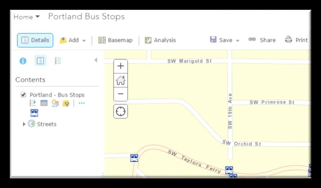
1 Enabling High-Quality Printing in Web Applications Tanu Hoque & Jeff Moulds
2 Print Service Technical Session Outline What s new in 10.6x What is Print Service Out of the box print solutions Print service with my own custom layout template ArcPy based advanced print solution - Include attributes in print output (Popup print) Security


3 New Modern Print Service with ArcGIS Enterprise 10.6 ArcGIS Pro based print service Quality Improvements: Support for true color level transparency PDF produced with vector features with transparency or picture symbol etc. In Layouts Templates: - are ArcGIS Pro layouts - Unicode support in legend item - Ghost (named Overlay X ) layers removed - Legend patches show with correct fill and outline - Legend patches don t get pixelated - Map scale is computed at the middle of the current map extent RESOLVED Sample incorrect outputs from or older printing services


4 What s New? New capabilities: - Vector tile layers - Smart mapping - Vector renderer off raster layers
5 Migrate to 10.6 You ll want the ArcGIS Server 10.6 Printing and Script Tool Patch Out of box Printing Service (Utilities/PrintingTools) will be upgraded - Your own custom print services will NOT be updated
6 Client APIs To Work With New Features Requires custom apps using - ArcGIS API for JavaScript 3.24 or above - ArcGIS API for JavaScript 4.6 or above Supported in: - ArcGIS Online map viewer (April 2018 Release) - ArcGIS Enterprise portal map viewer - Web AppBuilder built into Enterprise portal Web AppBuilder Developer Edition 2.8
7 Publishing Print Service from ArcGIS Pro directly to ArcGIS Server?


8 Print Services
9 Print Service What it is? Why do I need one?


10 Why Print Service? Demo
11 Firewall Public Map Service ArcGIS Online Printing Service with Public Services ExportWebMap JSON Web Application Printing Service on AGOL Output in PDF, PNG etc
12 Firewall ArcGIS Online Printing Service - Accessing Internal Services ExportWebMap JSON Web Application Printing Service on AGOL Private Map Service


13 Firewall ArcGIS Online Printing Service with Public Services ExportWebMap JSON Web Application Output in PDF, PNG etc Your Own Printing Service Public Map Service Private Map Service
14 High Quality Printing on the Web Primary Goals: - Create a printable document (PDF preferably) - Have that document printed to exact scale - Leverage ArcGIS Pro layouts - Support large format plots - Display ALL contents of my Web map - Services, graphics, feature layers, etc. - Be able to modify the map content during the process - High DPI We created a 3 tiered approach to meet these needs
15 Printing Service Overview Print services are powered by WebMaps - Consistent format produced by all the ArcGIS APIs - JSON based spec for sharing services, graphics, symbols etc. Note: The services in the WebMap must be accessible to the Print Service - Firewalls etc. JavaScript Apps Etc. WebMap Print Service (Export WebMap) PDF etc.
16 High Quality Printing 3 Tiered Approach : Tier 1 Simple printing Out of the box Geoprocessing Service with ArcGIS Enterprise Small format Synchronous
17 High Quality Printing 3 Tiered Approach : Tier 2 Custom configuration Ability to supply your own templates Asynchronous if desired Large format
18 Custom Configuration Publish the Export Web Map tool as your own service - Use your own layout templates - Branding logo, layout design, fonts etc. - Choose to make the service asynchronous if desired - This choice depends on the size of your prints and the length of time they ll take
19 Publishing Custom Print Service Layout templates Remove all existing layers Updating existing templates will not need republishing - Unless you didn t register template folder to the data store


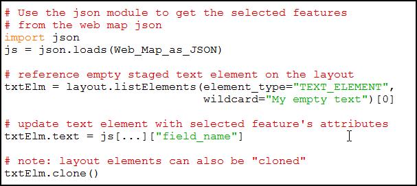
20 Retrieving Layout Template Metadata New task with Printing Services to return metadata about available layout templates - It is an arcpy-based script tool. Tool in ArcGIS Pro Task in Service Directory Custom Text Elements showing up in WAB
21 Retrieving Layout Template Metadata: Task Result { "pagesize": [ 8.5, 11.0 ], "layouttemplate": "Hamilton_County_Portrait", "activedataframesize": [ 7.75, 8.0 ], "layoutoptions": { "hasauthortext": false, "hascopyrighttext": false, "hastitletext": false, "haslegend": false, "customtextelements": [{ "subdiv" : "" }, { "city" : "" }, { "township" : "" }, { "info : "Parcel lists:" }] }
22 High Quality Printing 3 Tiered Approach : Tier 3 Advanced cases Supported via arcpy.mp Map & layer addition, replacement, etc.
23 Advanced Print Service Using arcpy Jeff Moulds
24 Security Print web map containing secured services
25 Can I Use Secured Services with Printing Service? Secured Services are supported - Short term token (optionally with referrer) Web tier level security supported when server is federated to a portal - e.g. Windows Integrated Authentication

26 Printing Service how does it work with secured services? ExportWebMap JSON token Web Application Printing Service Output in PDF, PNG etc token token A Secured Service


27 Web Tier Web Tier mydomain/user1 Printing Service Web Tier Security ExportWebMap JSON Web Application Printing Service ArcGIS Server Account ArcGIS Server Account mydomain/user1 A Secured Service ArcGIS Server Account

28 Portal mydomain/user1 Printing Service Web Tier Security and Portal ExportWebMap JSON token Web Application Printing Service Output in PDF, PNG etc token mydomain/user1 A Secured Service Portal token
29 Tips

 dynamiclayers = True")
30 Printing Cached Services Raster tiles typically created at 96 DPI Dynamic layer support can be enabled for Map Services - Allows for printing at higher DPI than cached images - You must have Publisher or Admin privileges to update the service dynamiclayers = False (600 DPI) dynamiclayers = True (600 DPI)

31 Enabling Dynamic Layers Option in properties of a cached service


32 ArcGIS Online Organization & ArcGIS Enterprise Register your own print service Print on-premises services behind a firewall


33 Layout Templates Location and Register to ArcGIS Server Option #1: when folder is not registered, templates get copied to server Updates to templates require republishing

34 Layout Templates Location and Register to ArcGIS Server Option #2: in a network shared folder Option #3: Unmanaged folder on the server Update templates without republishing or restarting
35 Layout Templates Location and Registered Data Stores Option #2: in a network shared folder Option #3: Unmanaged folder on the server
36 Wait! You didn t actually print anything Printing services are about generating printable documents (PDF etc.) If you wish to send the output to a physical printer automatically - Use the arcpy.mp workflow - Local printers xcopy to local share on some printers - Cloud printing workflows (e.g. Google Cloud Print) - Driverless printing - Simple APIs that can be called from Python
37 Three Web Map printing development paths Create your web app using the JavaScript API or the Web AppBuilder Simple printing with the out of the box print service. Arcpy.mp custom print service Use the out of the box print service with your own custom layout templates
38 Advanced web map printing with arcpy.mp Full capabilities of arcpy.mp: - Export using advanced options (e.g. high DPI or embed feature attributes in PDF) - Export map series - Export to PDF and insert additional PDF pages (title page, reports, driving directions, street index, etc.) - Printing pop-ups and feature attributes - Update layout elements (e.g. update a picture) - Swap out cached service layers for staged local vector data for vector PDF output - Etc.


39 Advanced web map printing with arcpy.mp JavaScript API & Web AppBuilder arcpy.mp. ConvertWebMapToArcGISProject High-quality cartographic output (e.g. PDF) The Print Widget in the web app will use your python script Arcpy.mp method for converting Web Maps to ArcGIS Pro Projects: ConvertWebMapToMapArcGISProject(webmap_json, {template_pagx}, {mapframe_name}, {notes_gdb}) Return a printer-friendly output file (PDF, PNG, etc.) Supports client side graphics in your web app.
 PDF export options: Embed feature attributes Embed georeferencing info Control layer visibility Utilize dynamic layout elements: Extent Indicators Dynamic Grids Dynamic Tables (new at 2.")
40 Advanced web map printing with arcpy.mp - James Bond Demo Map Series (arcpy.mp.mapseries class new at 2.1) PDF export options: Embed feature attributes Embed georeferencing info Control layer visibility Utilize dynamic layout elements: Extent Indicators Dynamic Grids Dynamic Tables (new at 2.1) Dynamic Text Dynamic Table Attributes (new at 2.2) Dynamic Table Statistics (new at 2.2) Dynamic Charts (new at 2.0)
41 Get web map JSON Get output format Get layout template ConvertWebMapToArc GISProject Referencing variables Turn off web layers Select by location Export to PDF Output file for job


42 Advanced web map printing with arcpy.mp Blog post: printing pop-ups -


43 Advanced web map printing with arcpy.mp Printing geodatabase attachments (e.g. pictures)
44 Advanced web map printing with arcpy.mp help topics Introduction to arcpy.mp - Web map printing with arcpy.mp help topic - (new topic at 2.2) Make a layout tutorial -


45 Please Take Our Survey on the App Download the Esri Events app and find your event Select the session you attended Select the Feedback tab Complete answers and select Submit
46 See Us Here WORKSHOP ArcGIS Pro: Mapping and Visualization Python: Map Automation in ArcGIS Pro LOCATION Room 01 A/B Room 33 A/B TIME FRAME 4:00 am 5:00 pm 8:30 am 09:30 am

47
Enabling High-Quality Printing in Web Applications. Tanu Hoque & Craig Williams
 Enabling High-Quality Printing in Web Applications Tanu Hoque & Craig Williams New Modern Print Service with ArcGIS Enterprise 10.6 Quality Improvements: Support for true color level transparency PDF produced
Enabling High-Quality Printing in Web Applications
 Esri Developer Summit March 7 10, 2017 Palm Springs, CA Enabling High-Quality Printing in Web Applications Craig Williams & Tanu Hoque High Quality Printing on the Web Primary Goals: - Create a printable
Enabling High-Quality Printing in Web Applications
 Esri Developer Summit March 8 11, 2016 Palm Springs, CA Enabling High-Quality Printing in Web Applications Craig Williams & Tanu Hoque High Quality Printing on the Web Primary Goals: - Create a printable
Working with Printing Service: Advanced Topics JEFF MOULDS TANU HOQUE
 Working with Printing Service: Advanced Topics JEFF MOULDS TANU HOQUE Session outline Subhead Here What is printing service and how it works? Use secured services with printing service ArcPy based printing
Enabling High-Quality Printing in Web Applications. Tanu Hoque & Scott Moore
 Enabling High-Quality Printing in Web Applications Tanu Hoque & Scott Moore High Quality Printing on the Web Create a printable document (PDF preferably) Have that document printed to exact scale Leverage
Python Map Automation Beyond the Basics of arcpy.mapping
 2013 Esri International User Conference July 8 12, 2013 San Diego, California Technical Workshop Python Map Automation Beyond the Basics of arcpy.mapping Jeff Barrette Jeff Moulds Esri UC2013. Technical
Web AppBuilder Presented by
 Web AppBuilder Presented by Agenda Product overview Web AppBuilder for ArcGIS tour What s new in the ArcGIS Online June 2016 update Customization Community and Resources Summary The ArcGIS Platform enables
Designing and Using Cached Map Services
 Esri International User Conference San Diego, California Technical Workshops July 2012 Designing and Using Cached Map Services Sterling Quinn Eric Rodenberg What we will cover Session Topics - Map cache
ArcGIS Runtime SDKs Building Offline Apps. Nick Furness
 ArcGIS Runtime SDKs Building Offline Apps Nick Furness Agenda The basics - Considerations - Building blocks - Service types New! Offline maps New! Preplanned workflow What we are covering and what not
Working with Feature Layers. Russell Brennan Gary MacDougall
 Working with Feature Layers Russell Brennan Gary MacDougall Working with Feature Layers Session will focus on feature access and editing Highlight new features added over the last few releases Agenda Introduction
What s New in ArcGIS 10.4 for Server
 What s New in ArcGIS 10.4 for Server Derek Law, Esri Jan 19, 2016 Esri Southwest User Conference Agenda Product story GIS Server Sharing content from ArcGIS Pro Portal for ArcGIS Client Apps Summary Strongly
Web App Builder: Code-free Development. Adam Ziegler, Esri-Northeast, Local Government Team
 Web App Builder: Code-free Development Adam Ziegler, aziegler@esri.com Esri-Northeast, Local Government Team Agenda Product overview Web AppBuilder for ArcGIS tour Adding Custom Widgets Community and Resources
ArcGIS for Server: Publishing and Using Map Services
 ArcGIS for Server: Publishing and Using Map Services Matthias Schenker Gerhard Trichtl m.schenker@esri.ch g.trichtl@mysynergis.com Agenda Platform overview Publishing services - Demo: Publishing hosted
Best Practices for Designing Effective Map Services
 2013 Esri International User Conference July 8 12, 2013 San Diego, California Technical Workshop Best Practices for Designing Effective Map Services Ty Fitzpatrick Tanu Hoque What s in this session Map
ArcGIS for Server: What s New. Philip Heede, Jay Theodore
 ArcGIS for Server: What s New Philip Heede, Jay Theodore Agenda GIS server Web GIS: Portal for ArcGIS ArcGIS for Server Extensions - GeoEvent Extension - Production Mapping Primary target for new functionality
Configuring ArcGIS Enterprise in Disconnected Environments
 Configuring ArcGIS Enterprise in Disconnected Environments BILL MAJOR Disconnected Environments Not everyone has internet access? How many of you run disconnected today, i.e. no internet access? Many customers
Customizing Web AppBuilder using Third Party Products. Presented to: Esri Canada Toronto UC Presented by: Maura Daffern October 11 th, 2018
 Customizing Web AppBuilder using Third Party Products Presented to: Esri Canada Toronto UC Presented by: Maura Daffern October 11 th, 2018 Introduction Third Party Products? Who Am I? Agenda What is the
ArcGIS Enterprise: Sharing Imagery. Zikang Zhou Imagery and Raster team
 ArcGIS Enterprise: Sharing Imagery Zikang Zhou Imagery and Raster team ArcGIS Enterprise: Sharing Imagery PowerPoint slides will be available online. Send me an E-mail if you need it faster: zzhou@esri.com
ArcGIS Enterprise: Advanced Topics in Administration. Thomas Edghill & Moginraj Mohandas
 ArcGIS Enterprise: Advanced Topics in Administration Thomas Edghill & Moginraj Mohandas Outline Overview: Base ArcGIS Enterprise Deployment - Key Components - Administrator Endpoints Advanced Workflows:
ArcGIS Enterprise: Portal Administration BILL MAJOR CRAIG CLEVELAND
 ArcGIS Enterprise: Portal Administration BILL MAJOR CRAIG CLEVELAND Agenda Welcome & Introduction to ArcGIS Enterprise Portal for ArcGIS - Basic Configuration - Advanced Configuration - Deploying Apps
Introduction to Web AppBuilder for ArcGIS: JavaScript Apps Made Easy
 Introduction to Web AppBuilder for ArcGIS: JavaScript Apps Made Easy Jianxia Song & Derek Law July 21, 2015 Agenda Product overview Web AppBuilder for ArcGIS tour What s New July 2015 ArcGIS Online update
Sharing Web Layers and Services in the ArcGIS Platform. Melanie Summers and Ty Fitzpatrick
 Sharing Web Layers and Services in the Platform Melanie Summers and Ty Fitzpatrick Agenda Platform overview - Web GIS information model - Two deployment options Pro Sharing - User experience and workflows
No Programming Required Create web apps rapidly with Web AppBuilder for ArcGIS
 No Programming Required Create web apps rapidly with Web AppBuilder for ArcGIS By Derek Law, Esri Product Manager, ArcGIS for Server Do you want to build web mapping applications you can run on desktop,
Python: Beyond the Basics. John Lam Esri China (Hong Kong) Richard Chau Esri China (Hong Kong)
 Richard Chau Esri China (Hong Kong)") Python: Beyond the Basics John Lam Esri China (Hong Kong) Richard Chau Esri China (Hong Kong) Basic rules Reference an MXD using a path or current keyword - When using CURRENT - Always run in foreground,
Python: Beyond the Basics John Lam Esri China (Hong Kong) Richard Chau Esri China (Hong Kong) Basic rules Reference an MXD using a path or current keyword - When using CURRENT - Always run in foreground,
Expand Your Audience through ArcGIS Online Workshop 2018 IMAGIN Conference
 Workshop 2018 IMAGIN Conference Park Place Hotel and Conference Center June 19, 2018 Welcome Introductions Logistics Bathrooms Schedule (10 am-1 pm) What is ArcGIS Online? Organizational Settings Break
ArcGIS Enterprise Security: An Introduction. Gregory Ponto & Jeff Smith
 ArcGIS Enterprise Security: An Introduction Gregory Ponto & Jeff Smith Agenda ArcGIS Enterprise Security Model Portal for ArcGIS Authentication Authorization Building the Enterprise Encryption Collaboration
Web AppBuilder for ArcGIS: JavaScript Apps Made Easy
 Web AppBuilder for ArcGIS: JavaScript Apps Made Easy Ryan Sellman @rcsellman Agenda Product overview Web AppBuilder for ArcGIS tour Customization Community and Resources Summary The ArcGIS Platform enables
Introduction to Your First ArcGIS Enterprise Deployment. Thomas Edghill & Jonathan Quinn
 Introduction to Your First ArcGIS Enterprise Deployment Thomas Edghill & Jonathan Quinn Overview Web GIS options with Esri Building a Base ArcGIS Enterprise Deployment - Overview of Base ArcGIS Enterprise
ArcGIS GeoEvent Server: Leveraging Stream Services. Ken Gorton RJ Sunderman
 ArcGIS GeoEvent Server: Leveraging Stream Services Ken Gorton RJ Sunderman Agenda 1 2 3 4 5 Overview of Stream Services & Stream Layers Publishing Stream Services Visualization of real-time data Sample
Advanced Parcel Editing. Amy Andis Tim Hodson
 Advanced Parcel Editing Amy Andis Tim Hodson Overview What to expect in this technical workshop Review of the Parcel Fabric Data Model Advanced Tips and tricks for Parcel entry Assessing Quality of Parcel
Creating Geoprocessing Services and Web Tools. Darren Baird, PE, Esri
 Creating Geoprocessing Services and Web Tools Darren Baird, PE, Esri Introduction Both ArcMap and ArcGIS Pro are covered Terms Geoprocessing Services and Web Tools are the same - ArcMap publishes geoprocessing
Administering Your ArcGIS Enterprise Portal Bill Major Craig Cleveland
 Administering Your ArcGIS Enterprise Portal Bill Major Craig Cleveland Agenda Welcome & Introduction to ArcGIS Enterprise Portal for ArcGIS Administration - Basic Configuration - Advanced Configuration
Data Interoperability An Introduction
 Data Interoperability An Introduction Bruce Harold Dale Lutz - Esri Inc - Safe Software What is the Data Interoperability Extension? Moving data from app to app ETL in industry jargon If you are not the
ArcGIS Hub: Open data best practices. Graham Hudgins, esri product engineer
 ArcGIS Hub: Open data best practices Graham Hudgins, esri product engineer Agenda Overview of open data in the ArcGIS Hub Example sites - Hubs Around the World Storymap Making a good site map Preparing
ArcGIS Runtime: Styling Maps. Ralf Gottschalk, Daniel Lee, Lucas Danzinger
 ArcGIS Runtime: Styling Maps Ralf Gottschalk, Daniel Lee, Lucas Danzinger Map Styling What is this session about? Creating beautiful functional maps for your Runtime Apps - Not about cartography It is
ArcGIS Online. The Road Ahead Geoff Mortson
 ArcGIS Online The Road Ahead Geoff Mortson gmortson@esricanada.com ArcGIS Online Easily create and share maps Delivered as intelligent maps Access on virtually any device anyone, anywhere Compliments and
ArcGIS GeoEvent Server: Making 3D Scenes Come Alive with Real-Time Data
 ArcGIS GeoEvent Server: Making 3D Scenes Come Alive with Real-Time Data Morakot Pilouk, Ph.D. Senior Software Developer, Esri mpilouk@esri.com @mpesri Agenda 1 2 3 4 5 6 3D for ArcGIS Real-Time GIS Static
Publishing and Using Map Services with ArcGIS for Server. Craig Williams, Ty Fitzpatrick, & Tanu Hoque
 Publishing and Using Map Services with ArcGIS for Server Craig Williams, Ty Fitzpatrick, & Tanu Hoque Agenda Platform overview Publishing services - Demo: Publishing hosted feature service - Demo: Publishing
Making the Most of Raster Analysis with Living Atlas Data. Aileen Buckley, PhD, Research Cartographer Esri - Redlands
 Making the Most of Raster Analysis with Living Atlas Data Aileen Buckley, PhD, Research Cartographer Esri - Redlands Spatial Analysis with Online Data Your Desktop Web Device Never scrounge for or download
Operations Dashboard for ArcGIS Monitoring GIS Operations. Michele Lundeen Esri
 Operations Dashboard for ArcGIS Monitoring GIS Operations Michele Lundeen Esri mlundeen@esri.com What is a dashboard? Conceptual term, can mean different things to different audiences Dashboards provide
ArcGIS Enterprise: Configuring Backups, Disaster Recovery, and Replication. Harrold Sompotan and Patrick Jackson
 ArcGIS Enterprise: Configuring Backups, Disaster Recovery, and Replication Harrold Sompotan and Patrick Jackson Agenda Brief History of WebGIS DR Tool Who, Why, What, When, How and Where Considerations
Collector for ArcGIS: What s New. Chris LeSueur & James Tedrick
 Collector for ArcGIS: What s New Chris LeSueur & James Tedrick Outline Product overview Workflows Preparing data for Collector for ArcGIS What s new in Collector for ArcGIS v18.1.0 (Aurora) Advanced topics
ArcGIS Enterprise: Architecture & Deployment. Anthony Myers
 ArcGIS Enterprise: Architecture & Deployment Anthony Myers 1 2 3 4 5 Web GIS Overview of ArcGIS Enterprise Federation & Hosted Server Deployment Patterns Implementation 1 Web GIS ArcGIS Enabling GIS for
ArcGIS for Server Michele Lundeen
 ArcGIS for Server 10.1 Michele Lundeen Summary Vision Installation and Configuration Architecture Publishing Functional Enhancements Cloud Migration and Best Practices Powerful GIS capabilities Delivered
Modernizing California State Highway Right of Way Records with GIS. Caltrans District 4 Oakland, CA
 Modernizing California State Highway Right of Way Records with GIS Caltrans District 4 Oakland, CA About Us Kirsten Lawrence (GISP), Senior Geospatial Analyst on staff augmentation contract with Caltrans
Getting Started with ArcGIS for Server. Charmel Menzel and Ken Gorton
 Getting Started with ArcGIS for Server Charmel Menzel and Ken Gorton Agenda What is ArcGIS for Server? Types of Web services Publishing resources onto the Web Clients to ArcGIS for Server Editions and
ArcGIS Viewer for Microsoft Silverlight An Introduction
 Esri International User Conference San Diego, CA Technical Workshops July 12, 2011 ArcGIS Viewer for Microsoft Silverlight An Introduction Art Haddad, Rich Zwaap, and Derek Law Agenda Background Product
What should y you expect in this session? Basic to advanced topics Outline What is map caching? Why should I cache? Caching workflow How to create a c
 Designing, Deploying, and Using Cached Map Services David Crosby & Craig Mesimer What should y you expect in this session? Basic to advanced topics Outline What is map caching? Why should I cache? Caching
Building Java Apps with ArcGIS Runtime SDK
 Building Java Apps with ArcGIS Runtime SDK Mark Baird and Vijay Gandhi A step back in time Map making 50 years ago - http://www.nls.uk/exhibitions/bartholomew/maps-engraver - http://www.nls.uk/exhibitions/bartholomew/printing
ArcGIS Online A Security, Privacy, and Compliance Overview. Andrea Rosso Michael Young
 ArcGIS Online A Security, Privacy, and Compliance Overview Andrea Rosso Michael Young ArcGIS Online A Multi-Tenant System Portal Portal Portal ArcGIS Online Agenda Online Platform Security Deployment Architecture
Understanding and using Metadata across the ArcGIS Platform. Aleta Vienneau Marten Hogeweg
 Understanding and using Metadata across the ArcGIS Platform Aleta Vienneau Marten Hogeweg Understanding and using Metadata across the ArcGIS Platform Metadata fundamentals ArcGIS platform Road ahead Metadata
Automating Distributed Raster Analysis using the Image Server REST API. Jie Zhang Zikang Zhou Demo Theater 2 - Oasis 1
 Automating Distributed Raster Analysis using the Image Server REST API Jie Zhang Zikang Zhou Demo Theater 2 - Oasis 1 What is Distributed Raster Analysis? From 10.5, ArcGIS has a new way to create and
How To Configure & Use Insights for ArcGIS ARAVIND SIVASAILAM MATT THOMAS
 How To Configure & Use Insights for ArcGIS ARAVIND SIVASAILAM MATT THOMAS Who is this for? ArcGIS Enterprise Publishers & Administrators ArcGIS Enterprise Users (Little to No Experience with Insights)
JANUARY Migrating standalone ArcGIS Server to ArcGIS Enterprise
 JANUARY 2018 Migrating standalone ArcGIS Server to ArcGIS Enterprise Copyright 2018 Esri All rights reserved. Printed in the United States of America. The information contained in this document is the
Architect your deployment using Chef
 ArcGIS Enterprise Architect your deployment using Chef Cherry Lin and Scott MacDonald ArcGIS Enterprise base deployment Why automate your ArcGIS Enterprise deployment? Efficiency Get up and running faster
Building Basemaps: MapCaches and VectorTiles. Matthias Schenker Gerhard Trichtl
 Building Basemaps: MapCaches and VectorTiles Matthias Schenker Gerhard Trichtl What are Basemaps for Basemaps provide a optimal background and orientation for displaying your data on top Should be - Fast
Developing Imagery Apps Using the ArcGIS API for JavaScript and WebApp Builder. Naila Khan, Chayanika Khatua
 Developing Imagery Apps Using the ArcGIS API for JavaScript and WebApp Builder Naila Khan, Chayanika Khatua What are we talking about today Custom applications Map Viewer Web AppBuilder ArcGIS API for
Understanding and Using Metadata in ArcGIS. Adam Martin Marten Hogeweg Aleta Vienneau
 Understanding and Using Metadata in ArcGIS Adam Martin Marten Hogeweg Aleta Vienneau Adam Martin National Government Account Management R&D Open Data Marten Hogeweg National Government Professional Services
VECTOR TILES: STYLING YOUR OWN BASE MAPS. Andrew Green René Rubalcava Andy Skinner
 VECTOR TILES: STYLING YOUR OWN BASE MAPS Andrew Green René Rubalcava Andy Skinner Introducing Vector Tiles Andrew Green What are Esri Vector Tile Basemaps? Introduction Basemaps cached and delivered as
TRAINING GUIDE. GIS Session Preview (New Features) 2017 and 2017r2
 2017 and 2017r2") TRAINING GUIDE GIS Session Preview (New Features) 2017 and 2017r2 GIS Session Preview (New Features) 2017 and 2017r2 In this session, we ll provide an overview of GIS changes since ACT 2016 and a sneak
TRAINING GUIDE GIS Session Preview (New Features) 2017 and 2017r2 GIS Session Preview (New Features) 2017 and 2017r2 In this session, we ll provide an overview of GIS changes since ACT 2016 and a sneak
Esri Production Mapping: Configuring the Solution for Civilian Topographic Agencies. Sean Granata
 Esri Production Mapping: Configuring the Solution for Civilian Topographic Agencies Sean Granata What s New Version 4.0 (Released) - Distributed Generalization Version 5.0 - Support for 10K Map Products
Real-Time GIS: Leveraging Stream Services
 Real-Time GIS: Leveraging Stream Services Mark Bramer Senior Technical Analyst Esri Professional Services mbramer@esri.com RJ Sunderman Product Engineer GeoEvent Extension Product Team rsunderman@esri.com
Desktop Mapping: Creating Vector Tiles. Craig Williams
 Desktop Mapping: Creating Vector Tiles Craig Williams Edie Punt @williamscraigm @epunt Overview Why vector tiles? Vector tiles in ArcGIS ArcGIS vector tile basemaps Consuming and styling vector tiles Overview
Developing Qt Apps with the Runtime SDK
 Developing Qt Apps with the Runtime SDK Thomas Dunn and Michael Tims Esri UC 2014 Technical Workshop Agenda Getting Started Creating the Map Geocoding and Routing Geoprocessing Message Processing Work
Building Applications with the ArcGIS Runtime SDK for WPF
 Esri International User Conference San Diego, California Technical Workshops 24 th July 2012 Building Applications with the ArcGIS Runtime SDK for WPF Euan Cameron & Paul Pilkington Agenda Introduction
An Introduction to GIS for developers
 An Introduction to GIS for developers Part 4: GIS Sharing Canserina Kurnia & Tom Shippee Agenda Web GIS ArcGIS Online Cloud-based ArcGIS Server ArcGIS Server on-premises ArcGIS a complete platform discover,
Extending ArcGIS for Server. Jon Satchwell, Esri Switzerland Cédric Despierre Corporon, Esri France
 Extending ArcGIS for Server Jon Satchwell, Esri Switzerland Cédric Despierre Corporon, Esri France Agenda Introduction Server Object Extensions Server Object Interceptors THE BIG WEBGIS PICTURE Introduction
ArcGIS Enterprise: An Introduction. David Thom Solution Engineer State Government
 ArcGIS Enterprise: An Introduction David Thom Solution Engineer State Government What is ArcGIS Enterprise? ArcGIS Enterprise is server software that allows you to use infrastructure you manage to implement
ArcGIS Desktop: Fundamentals of Cartography
 ArcGIS Desktop: Fundamentals of Cartography Outline Symbology Style Files -.style Layer files -.lyr Labeling Label Classes Label Expressions Map Document files -.mxd Map Template files -.mxt Map Elements
Setup Guide for Op Tracker
 Setup Guide for Op Tracker Contents 1 Welcome to Op Tracker... 2 2 Data Overview... 3 2.1 Block Boundary Feature Layer... 3 2.2 Block Tracking Feature Layer... 3 2.3 Ancillary Data Feature Layer... 3 2.4
What s New in Desktop 10.1
 What s New in Desktop 10.1 Damian Spangrud Esri Redlands Trip Down Memory Lane ArcGIS A Complete System for Geographic Information Cloud Web Online Mobile Enterprise Desktop Sharing Information sharing
Building Geoprocessing Tools with Python: Beyond the Basics. Dave Wynne
 Building Geoprocessing Tools with Python: Beyond the Basics Dave Wynne Building Geoprocessing Tools with Python: Getting Started Subhead Here This session will focus on creating polished, well-designed
ArcGIS Runtime SDK for Java: A Beginner s Guide. Mark Baird JC Malott
 ArcGIS Runtime SDK for Java: A Beginner s Guide Mark Baird JC Malott Outline Intro to ArcGIS Runtime SDKs Get started: download and install the SDK Tour of the functionality of the API Basics of building
Implementing a Hybrid Approach to ArcGIS. Philip McNeilly and Margaret Jen
 Implementing a Hybrid Approach to ArcGIS Philip McNeilly and Margaret Jen Difficulty Level: Intermediate Overview What you will learn: - How to successfully integrate and work with services from ArcGIS
FAQ & Troubleshooting
 FAQ & Troubleshooting What is the most common issue users have when using the site? Pop-Up Blocker!!! Any link external to the viewer requires a new window to be opened in the browser. See My map or report
ArcGIS for Server: Optimizing Performance and Scalability
 ArcGIS for Server: Optimizing Performance and Scalability Anthony Myers & Kevin Armstrong Introduction Today we will discuss - Architecture - Map and Image Services - What s New - Tips and Techniques Throughout
ArcGIS for Server Administration. Andrew Sakowicz
 ArcGIS for Server Administration Andrew Sakowicz asakowicz@esri.com Target audience Administrators (GIS, DBA, System) Architects Developers Level: Intermediate Outline Key administrative functions Configuring
Survey123 Deep Dive. Presented by: Sue Enyedy-Goldner Fall 2018
 Survey123 Deep Dive Presented by: Sue Enyedy-Goldner Fall 2018 Today s Agenda 1. Overview of Survey123 - getting stared with Web Designer 2. Create smarter surveys - using Survey123 Connect 3. Examine
Migrating to ArcGIS Pro. John Sharrard, Esri Solutions Engineer
 Migrating to ArcGIS Pro John Sharrard, Esri Solutions Engineer jsharrard@esri.com ArcGIS Desktop Desktop Web Device ArcMap ArcCatalog ArcScene ArcGlobe ArcGIS Pro Portal Server Online Content and Services
ArcGIS Enterprise Security: An Introduction. Randall Williams Esri PSIRT
 ArcGIS Enterprise Security: An Introduction Randall Williams Esri PSIRT Agenda ArcGIS Enterprise Security for *BEGINNING to INTERMIDIATE* users ArcGIS Enterprise Security Model Portal for ArcGIS Authentication
Advanced PDF features
 1 of 7 2/17/2009 10:56 PM Show Navigation Hide Navigation You are here: Mapping and v isualization > Page layout and map composition > Map output Advanced PDF features Release 9.3 Last modified November
ArcGIS Online: Managing Data. Jeremy Bartley Sentha Sivabalan
 ArcGIS Online: Managing Data Jeremy Bartley (jbartley@esri.com) Sentha Sivabalan (ssivabalan@esri.com) Agenda Creating and managing content like Apps, Maps, Scenes and Layers in ArcGIS Today s Topics:
ArcGIS Server and Portal for ArcGIS An Introduction to Security
 ArcGIS Server and Portal for ArcGIS An Introduction to Security Jeff Smith & Derek Law July 21, 2015 Agenda Strongly Recommend: Knowledge of ArcGIS Server and Portal for ArcGIS Security in the context
ArcGIS Desktop: Making Maps in ArcMap
 ArcGIS Desktop: Making Maps in ArcMap California, Nevada, Hawaii Regional User Group February 6-8, 6 2008 Sacramento, CA Harry J. Moore IV Outline Symbology Style Files -.style Layer files -.lyr Labeling
Advanced Map Caching. Tom Brenneman
 Advanced Map Caching g Topics Sterling Quinn Tom Brenneman Schedule Advanced topics Key caching properties C Caching g strategies g Test caches Strategic cache creation On--demand caching On Creating a
ArcGIS Online: Three-and-a-Half Ways to Create Tile Layers. Eric Anderson & Adam Eversole Esri Support Services
 ArcGIS Online: Three-and-a-Half Ways to Create Tile Layers Eric Anderson & Adam Eversole Esri Support Services Agenda 1. Introduction 2. What is a tile layer 3. How a tile layer works 4. The 3 ½ ways to
Building Apps with the ArcGIS Runtime SDK for ios
 Building Apps with the ArcGIS Runtime SDK for ios Nick Furness @geeknixta ArcGIS Runtime SDKs 10.2 Released! Runtime platforms OS X Desktop Desktop Client Windows Store QT ios.net JavaSE Mobile Android
TRAINING GUIDE. ArcGIS Online and Lucity
 TRAINING GUIDE ArcGIS Online and Lucity ArcGIS Online and Lucity This covers some basic functionality we feel you will need to be successful with Lucity with ArcGIS Online or Portal for ArcGIS Enterprise.
Working with Scientific Data in ArcGIS Platform
 Working with Scientific Data in ArcGIS Platform Sudhir Raj Shrestha sshrestha@esri.com Hong Xu hxu@esri.com Esri User Conference, San Diego, CA. July 11, 2017 What we will cover today Scientific Multidimensional
ArcGIS Pro: Mapping & Visualization. David Watkins, Edie Punt &
 ArcGIS Pro: Mapping & Visualization David Watkins, Edie Punt & Craig Williams @daviddwatkins, @epunt, & @williamscraigm Mapping an Visualization Vision In ArcGIS Pro Improve drawing performance and quality
TRAINING GUIDE. Lucity GIS. Web Administration
 TRAINING GUIDE Lucity GIS Web Administration Lucity GIS Web Administration Contents Portal Config and SSO... 2 Registering with Portal... 2 Behind the Scenes... 4 Resetting Portal Integration... 5 Single
Using Geoprocessing Services in Web Applications. Kelly Hutchins, Kevin Hibma, Monica Joseph
 Using Geoprocessing Services in Web Applications Kelly Hutchins, Kevin Hibma, Monica Joseph Geoprocessing Services Publish Geoprocessing Toolbox through ArcGIS Server to create a Geoprocessing Service.
Getting Started with ArcGIS Runtime SDK for Java SE
 Getting Started with ArcGIS Runtime SDK for Java SE Elise Acheson, Vijay Gandhi, and Eric Bader Demo Source code: https://github.com/esri/arcgis-runtime-samples-java/tree/master/devsummit-2014 Video Recording:
ArcGIS Viewer for Silverlight Advanced Topics
 Esri International User Conference San Diego, California Technical Workshops July 26, 2012 ArcGIS Viewer for Silverlight Advanced Topics Rich Zwaap Agenda Add-ins overview Tools Behaviors Controls Layouts
ArcGIS API for JavaScript
 ArcGIS API for JavaScript Getting Started Bjorn Svensson, Undral Batsukh 1 Agenda Don't write code JavaScript development Use ArcGIS platform, use webmaps and webscenes js.arcgis.com The Big Four: layers,
Understanding ArcGIS Online - why organizations should embrace the cloud now
 Understanding ArcGIS Online - why organizations should embrace the cloud now Presented to: GeoAlberta - workshop Presented by: David Parry September 25, 2013 Today s Agenda Introduction - Why the Cloud?
Bringing your Data to Life in the ArcGIS API for JavaScript: Vector Tiles. Craig Williams &
 Bringing your Data to Life in the ArcGIS API for JavaScript: Vector Tiles Craig Williams & Rene Rubalcava @williamscraigm @odoenet Overview Why vector tiles? Vector tiles in ArcGIS ArcGIS vector tile basemaps
ArcGIS Online: Item Administration and Group Sharing. Brendan O Neill Caitlin Hillis
 ArcGIS Online: Item Administration and Group Sharing Brendan O Neill Caitlin Hillis Overwhelmed? You re in the right place. Overview ArcGIS Online sharing model Best practices for item administration
What s New in ArcGIS 10.3 for Server. Tom Shippee Esri Training Services
 What s New in ArcGIS 10.3 for Server Tom Shippee Esri Training Services Today s Agenda What is ArcGIS for Server at 10.3 - ArcGIS Platform story - Expanding ArcGIS for Server paradigm What s new in ArcGIS
Creating Apps Using ArcGIS Online Templates. Matt Kennedy
 Creating Apps Using ArcGIS Online Templates Matt Kennedy Topics we will cover The publishing process Before you publish Where apps live Breakdown of apps Publishing web app templates The steps for publishing