Indexed 3D Scene (I3S) Layers Specification
|
|
|
- Amberlynn Wells
- 5 years ago
- Views:
Transcription

1 Indexed 3D Scene (I3S) Layers Specification Javier Gutierrez Product Engineer Lead Esri Özgür Ertac 3D Product Engineer Esri Germany

2 Thank You to Our Generous Sponsor
3 Agenda ArcGIS 3D Platform Authoring 3D Scene Layers Indexed 3D Scene Layer

4
5
6 ArcGIS 3D Platform


7 ArcGIS 3D helps users Create and Manage Design and Simulate Visualize and Analyze Quickly and easily extract value from 2D and 3D data Understand and experience events and change Manage the designed environment


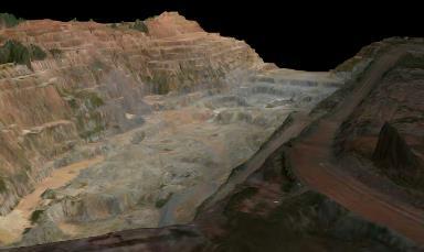

8 3D GIS across industries Mining Developing Energy resources Transportation Scientific Visualization City monitoring and planning Utilities and Telecommunications Environmental assessment Infrastructure Facilities Management Land Management
9 Authoring 3D Scene Layers


10 Scene Layers supported across the ArcGIS platform Web and Desktop Clients!


11 ArcGIS 3D Scene Layers 3D Objects Scene Layer 3D Point Scene Layer 3D Integrated Mesh Layer 3D Point Cloud Scene Layer 3D Objects Future: Line, Polygon.. 3D Integrated Mesh New!: 3D Point Cloud
12 I3S Support in ArcGIS Platform Scene layer types and product versions supporting Scene Layers ArcGIS Software Scene Layer Types 3D Object Integrated Mesh Point Point Cloud Publishing Consuming ArcGIS Online Current Current Current Current Yes Yes ArcGIS Enterprise Yes Yes ArcGIS Pro Yes Yes ArcGIS Earth Planned Planned - Yes Esri CityEngine Yes (.slpk) - Drone2Map Yes (.slpk) - Focused Solutions!

13 Demo Authoring and publishing 3D Scene Layers in ArcGIS Platform


14 I3S REST Interface for Web I3S - Sharing ArcGIS Enterprise (Portal) ArcGIS Online 3D Web Scene / 3D Web App as Client JS API 3D Model in a Geodatabase Processing with ArcGIS Pro SLPK GDB (zipped) SLPK local I3S Format for native apps 3D Desktop-/Mobile- Software as Client
15 Publishing Hosted 3D Scene Layers in ArcGIS Online Two ways of hosting 3D Scene Layers in ArcGIS Online 1. Create cache in ArcGIS Pro as SLPK and upload 2. Or cook the cache in ArcGIS Online - Allows cache update - Costs credits - 1 cr. per 1000 textured multipatch - 1 cr. per 5000 untextured multipatch - 1 cr. per 5000 features in feature layer More Details:
16 Indexed 3D Scene Layer Open 3D Service Format


17 Indexed 3D Scene Layer I3S I3S layer specification - Open specification for 3D layers - Shared under Creative Commons licensing - Already an OGC Community Standard! - Describes a scalable scene cache with attributes and indexing - Multiple levels of detail - Can be streamed over the internet/intranet - Can be used locally on disk as a scene layer package - Opportunity for future profiles to accommodate new data types - Open for feedback and modification - More here:

18 3 rd party adoption of I3S Integrated mesh - VRICON, Pix4D, and Bentley sharing packages or services in I3S format - Supports Drone2Map Vendor Product/URL Scene Layer Type Bentley ContextCapture Integrated Mesh Vricon Vricon Integrated Mesh Pix4D Pix4D Integrated Mesh More partners coming soon
19 Esri Indexed 3d Scene (*.i3s) and Scene Layer Package (*.slpk) formats Requirements for a 3D GIS visualization format 1. Web friendly: JSON + Typed Arrays 2. Mobile friendly: Works good with varying bandwidth 3. Extensible: Support different types of content 4. Declarative: Reduce required implicit knowledge 5. Efficient: Use spatial indexing for quick delivery (nodes!) 6. Scalable: Provide Level of Detail Support 7. Protected: Ensure that content is protected 8. Open: Full Specification publicly accessible Now
20 The Key to Scalability: Indexing Adapt Index type to data - R-Tree - Quadtree, Octtree - Standard Tiling Scheme Load-Balanced - Clustering based on content distribution Near-Constant Data Volume per Node Node ID 5 Representation Object ID 8 Low level of detail for scalability! Legend


21 Scene Services Resources & REST API 1 Node Index Document 1 Feature Data 1..* Geometry Files 0..* Texture Files 1 Shared Resource Service /SceneServer SceneServiceInfo.json - Layer /SceneServer/layers 3dSceneLayer.json - Symbols /SceneServer/layers/0/symbols/0 FeatureData.json - Node layers/0/nodes/0 NodeIndexDocument.json - Features layers/0/nodes/0/features/0 FeatureData.json - Geometry layers/0/nodes/0/geometry/0 Geometry Typed Array - Texture layers/0/nodes/0/textures/1_2 Image with Texture LoD - Shared Resource layers/0/nodes/0/shared sharedresource.json - Attributes layers/0/nodes/0/attributes attribute Typed Array

22 Declarative: Geometry buffer metadata Header vertexcount Body vertexattributes faceattributes featureattributes facecount position position id featurecount uv0 uv0 facerange normal normal color

23 Demo Debugging an I3S service

24 i3s persistence options Storing and serving i3s resources
25 1. File System Folder Layout Direct mapping of the REST API All resources reside in the file system as individual files. These files are organized in folders in the following schema: /3dSceneLayer.json /nodes/<node-id>/3dnodeindexdocument.json /nodes/<node-id>/features/0.json...n.json /nodes/<node-id>/geometries/0.bin...n.bin /nodes/<node-id>/shared/sharedresource.json /nodes/<node-id>/textures/0_0.bin...n_m.bin /nodes/<node-id>/attributes/0.bin...n.bin

26 3. Scene Layer Package *.slpk the i3s package format Best for single-file exchange and portability of i3s stores metadata.json Archive.slpk 3dScenelayer.json Zip64 container /nodes/ /nodes/root/ 3dNodeIndexDocument.json features/* geometries/* textures/* shared/* attributes/* gzip ed resources /nodes/ / 3dNodeIndexDocument.json features/* geometries/* textures/* shared/* attributes/*

27 Become a part of the community! Get Involved with I3S! Now Shared under Creative Commons licensing Toolkit License: Apache 2.0 Implement Encoders, Services, Clients!

28 Thanks! Questions?


29 Please Take Our Survey! Download the Esri Events app and go to DevSummit Select the session you attended Scroll down to the Feedback section Complete Answers, add a Comment, and Select Submit

30
3D in the Browser with WebGL. Chris Andrews 3D Product Manager Javier Gutierrez 3D Product Engineer
 3D in the Browser with WebGL Chris Andrews 3D Product Manager Javier Gutierrez 3D Product Engineer Just sayin This is not a programming class Goal is to help you learn about a technology area that impacts
ArcGIS Runtime: Building 3D Apps. Rex Hansen Adrien Meriaux
 ArcGIS Runtime: Building 3D Apps Rex Hansen Adrien Meriaux Agenda 3D across the ArcGIS Platform 3D in ArcGIS Runtime Road ahead ArcGIS 3D helps customers Create and Manage Design and Simulate Visualize
Understanding and Using Esri s Open i3s Specification
 Understanding and Using Esri s Open i3s Specification Keith Ryden Esri, Software Development Tamrat Belayneh Esri - Lead Software Developer 3D Services Athanasios Koukofikis HFT Stuttgart - Phd. Student
ArcGIS GeoEvent Server: Making 3D Scenes Come Alive with Real-Time Data
 ArcGIS GeoEvent Server: Making 3D Scenes Come Alive with Real-Time Data Morakot Pilouk, Ph.D. Senior Software Developer, Esri mpilouk@esri.com @mpesri Agenda 1 2 3 4 5 6 3D for ArcGIS Real-Time GIS Static
ArcGIS Online: Three-and-a-Half Ways to Create Tile Layers. Eric Anderson & Adam Eversole Esri Support Services
 ArcGIS Online: Three-and-a-Half Ways to Create Tile Layers Eric Anderson & Adam Eversole Esri Support Services Agenda 1. Introduction 2. What is a tile layer 3. How a tile layer works 4. The 3 ½ ways to
Sharing Web Layers and Services in the ArcGIS Platform. Melanie Summers and Ty Fitzpatrick
 Sharing Web Layers and Services in the Platform Melanie Summers and Ty Fitzpatrick Agenda Platform overview - Web GIS information model - Two deployment options Pro Sharing - User experience and workflows
ArcGIS Enterprise: Architecture & Deployment. Anthony Myers
 ArcGIS Enterprise: Architecture & Deployment Anthony Myers 1 2 3 4 5 Web GIS Overview of ArcGIS Enterprise Federation & Hosted Server Deployment Patterns Implementation 1 Web GIS ArcGIS Enabling GIS for
ArcGIS Online: Best Practices for High-Demand Web Applications. Kelly Gerrow-Wilcox Bonnie Stayer Beth Romero
 ArcGIS Online: Best Practices for High-Demand Web Applications Kelly Gerrow-Wilcox Bonnie Stayer Beth Romero Agenda Communicating with Maps Who do you build your apps for? Layer Types Scalability and Response
3D in the ArcGIS Platform. Chris Andrews
 3D in the ArcGIS Platform Chris Andrews Geospatial 3D is already all around us 3D is expanding the GIS community s opportunity to provide value 3D City & Infrastructure Models Generated 3D features Photogrammetrc
ArcGIS Runtime SDKs Building Offline Apps. Nick Furness
 ArcGIS Runtime SDKs Building Offline Apps Nick Furness Agenda The basics - Considerations - Building blocks - Service types New! Offline maps New! Preplanned workflow What we are covering and what not
Managing and Serving Elevation and Lidar Data. Cody Benkelman UC 2018
 Managing and Serving Elevation and Lidar Data Cody Benkelman UC 2018 Outline Usage Modes Data Management - Architecture - Workflow Automation for Repeatability & Scalability A few options Usage Modes of
Working with Feature Layers. Russell Brennan Gary MacDougall
 Working with Feature Layers Russell Brennan Gary MacDougall Working with Feature Layers Session will focus on feature access and editing Highlight new features added over the last few releases Agenda Introduction
ArcGIS Runtime SDK for Qt: Building Apps. Koushik Hajra and Lucas Danzinger
 ArcGIS Runtime SDK for Qt: Building Apps Koushik Hajra and Lucas Danzinger Cross-platform apps Agenda for today Intro to Qt Framework and ArcGIS Runtime SDK for Qt App design patterns with this SDK SDK
Configuring ArcGIS Enterprise in Disconnected Environments
 Configuring ArcGIS Enterprise in Disconnected Environments BILL MAJOR Disconnected Environments Not everyone has internet access? How many of you run disconnected today, i.e. no internet access? Many customers
ArcGIS Enterprise: Sharing Imagery. Zikang Zhou Imagery and Raster team
 ArcGIS Enterprise: Sharing Imagery Zikang Zhou Imagery and Raster team ArcGIS Enterprise: Sharing Imagery PowerPoint slides will be available online. Send me an E-mail if you need it faster: zzhou@esri.com
Integrating Imagery into ArcGIS Runtime Application. Jie Zhang, Zhiguang Han San Jacinto, 5:30 pm 6:30 pm
 Integrating Imagery into ArcGIS Runtime Application Jie Zhang, Zhiguang Han San Jacinto, 5:30 pm 6:30 pm Overviews Imagery is an essential component of ArcGIS - Visualization, Processing and Analysis -
Building Basemaps: MapCaches and VectorTiles. Matthias Schenker Gerhard Trichtl
 Building Basemaps: MapCaches and VectorTiles Matthias Schenker Gerhard Trichtl What are Basemaps for Basemaps provide a optimal background and orientation for displaying your data on top Should be - Fast
Sharing 3D Content on the Web
 Sharing 3D Content on the Web Nathan Shephard, Gert van Maren Why 3D GIS? Because our world is 3D Improve understanding 3D is easy for everyone to understand Better communication 3D makes it easier to
Understanding and using Metadata across the ArcGIS Platform. Aleta Vienneau Marten Hogeweg
 Understanding and using Metadata across the ArcGIS Platform Aleta Vienneau Marten Hogeweg Understanding and using Metadata across the ArcGIS Platform Metadata fundamentals ArcGIS platform Road ahead Metadata
ArcGIS Runtime SDK for.net Building Apps. Antti Kajanus David Cardella
 ArcGIS Runtime SDK for.net Building Apps Antti Kajanus akajanus@esri.com David Cardella dcardella@esri.com Thank You to Our Generous Sponsor SDK Highlights High-performance 2D and 3D mapping Integration
Trimble GeoCollector for ArcGIS: An Introduction. Morgan Zhang (Esri), Matthew Morris (Trimble)
, Matthew Morris (Trimble)") Trimble GeoCollector for ArcGIS: An Introduction Morgan Zhang (Esri), Matthew Morris (Trimble) Overview Introduction to mobile GIS Overview of ArcGIS for Windows Mobile Overview of Trimble Positions software
Trimble GeoCollector for ArcGIS: An Introduction Morgan Zhang (Esri), Matthew Morris (Trimble) Overview Introduction to mobile GIS Overview of ArcGIS for Windows Mobile Overview of Trimble Positions software
Enabling High-Quality Printing in Web Applications
 Esri Developer Summit March 7 10, 2017 Palm Springs, CA Enabling High-Quality Printing in Web Applications Craig Williams & Tanu Hoque High Quality Printing on the Web Primary Goals: - Create a printable
Data Interoperability An Introduction
 Data Interoperability An Introduction Bruce Harold Dale Lutz - Esri Inc - Safe Software What is the Data Interoperability Extension? Moving data from app to app ETL in industry jargon If you are not the
ArcGIS Enterprise Extending Services. Bill Major
 ArcGIS Enterprise Extending Services Bill Major Agenda Introduction Geoprocessing tools Server Object Extensions Server Object Interceptors Demo APPS Desktop Web Device SHARING SERVICES Portal API DATA
ArcGIS Enterprise: An Introduction. Philip Heede
 Enterprise: An Introduction Philip Heede Online Enterprise Hosted by Esri (SaaS) - Upgraded automatically (by Esri) - Esri controls SLA Core Web GIS functionality (Apps, visualization, smart mapping, analysis
ArcGIS Enterprise: Configuring Backups, Disaster Recovery, and Replication. Harrold Sompotan and Patrick Jackson
 ArcGIS Enterprise: Configuring Backups, Disaster Recovery, and Replication Harrold Sompotan and Patrick Jackson Agenda Brief History of WebGIS DR Tool Who, Why, What, When, How and Where Considerations
Creating and Maintaining Your 3D Basemap. Brian Sims Dan Hedges Gert van Maren
 Creating and Maintaining Your 3D Basemap Brian Sims Dan Hedges Gert van Maren Complementary Resource Email (no marketing) A copy of the presentation Links to today s web demos Links to training materials
Understanding and Using Metadata in ArcGIS. Adam Martin Marten Hogeweg Aleta Vienneau
 Understanding and Using Metadata in ArcGIS Adam Martin Marten Hogeweg Aleta Vienneau Adam Martin National Government Account Management R&D Open Data Marten Hogeweg National Government Professional Services
What s New in ArcGIS 10.3 for Server. Tom Shippee Esri Training Services
 What s New in ArcGIS 10.3 for Server Tom Shippee Esri Training Services Today s Agenda What is ArcGIS for Server at 10.3 - ArcGIS Platform story - Expanding ArcGIS for Server paradigm What s new in ArcGIS
ArcGIS for Server: Publishing and Using Map Services
 ArcGIS for Server: Publishing and Using Map Services Matthias Schenker Gerhard Trichtl m.schenker@esri.ch g.trichtl@mysynergis.com Agenda Platform overview Publishing services - Demo: Publishing hosted
ArcGIS Enterprise: Performance and Scalability Best Practices. Darren Baird, PE, Esri
 ArcGIS Enterprise: Performance and Scalability Best Practices Darren Baird, PE, Esri dbaird@esri.com What is ArcGIS Enterprise What s Included with ArcGIS Enterprise ArcGIS Server the core web services
What s New in ArcGIS 10.4 for Server
 What s New in ArcGIS 10.4 for Server Derek Law, Esri Jan 19, 2016 Esri Southwest User Conference Agenda Product story GIS Server Sharing content from ArcGIS Pro Portal for ArcGIS Client Apps Summary Strongly
What Makes a good content item GREAT?
 What Makes a good content item GREAT? Keith VanGraafeiland Tuesday - 4:30 PM - 5:15 PM SDCC - Demo Theater 04 - Living Atlas Overview Subhead Here Content items in ArcGIS Online Difficult to find what
Developing Cross-Platform Native Apps with AppStudio for ArcGIS. Jo Fraley Erwin Soekianto
 Developing Cross-Platform Native Apps with AppStudio for ArcGIS Jo Fraley Erwin Soekianto AppStudio for ArcGIS ios Android Linux 1App Windows Mac What is AppStudio for ArcGIS? A suite of productivity tools
Bringing your Data to Life in the ArcGIS API for JavaScript: Vector Tiles. Craig Williams &
 Bringing your Data to Life in the ArcGIS API for JavaScript: Vector Tiles Craig Williams & Rene Rubalcava @williamscraigm @odoenet Overview Why vector tiles? Vector tiles in ArcGIS ArcGIS vector tile basemaps
Making the Most of Raster Analysis with Living Atlas Data. Aileen Buckley, PhD, Research Cartographer Esri - Redlands
 Making the Most of Raster Analysis with Living Atlas Data Aileen Buckley, PhD, Research Cartographer Esri - Redlands Spatial Analysis with Online Data Your Desktop Web Device Never scrounge for or download
Enabling High-Quality Printing in Web Applications. Tanu Hoque & Jeff Moulds
 Enabling High-Quality Printing in Web Applications Tanu Hoque & Jeff Moulds Print Service Technical Session Outline What s new in 10.6x What is Print Service Out of the box print solutions Print service
Data Store Management Best Practices. Bill Major Laurence Clinton
 Data Store Management Best Practices Bill Major Laurence Clinton Session Agenda 1. Overview 2. Installation and Configuration 3. Backing up the data store 4. Restoring the data store 5. Moving data store
Extending ArcGIS for Server. Jon Satchwell, Esri Switzerland Cédric Despierre Corporon, Esri France
 Extending ArcGIS for Server Jon Satchwell, Esri Switzerland Cédric Despierre Corporon, Esri France Agenda Introduction Server Object Extensions Server Object Interceptors THE BIG WEBGIS PICTURE Introduction
ArcGIS Enterprise: An Introduction. David Thom Solution Engineer State Government
 ArcGIS Enterprise: An Introduction David Thom Solution Engineer State Government What is ArcGIS Enterprise? ArcGIS Enterprise is server software that allows you to use infrastructure you manage to implement
ArcGIS Runtime SDK for ios and macos: Building Apps. Suganya Baskaran, Gagandeep Singh
 ArcGIS Runtime SDK for ios and macos: Building Apps Suganya Baskaran, Gagandeep Singh Get Started Core Components Agenda - Display Map Content - Search for Content - Perform Analysis - Edit Content Summary
ArcGIS Pro: Image Segmentation, Classification, and Machine Learning. Jeff Liedtke and Han Hu
 ArcGIS Pro: Image Segmentation, Classification, and Machine Learning Jeff Liedtke and Han Hu Overview of Image Classification in ArcGIS Pro Overview of the classification workflow Classification tools
Understanding and Working with the OGC Geopackage. Keith Ryden Lance Shipman
 Understanding and Working with the OGC Geopackage Keith Ryden Lance Shipman Introduction - Introduction to Simple Features - What is the GeoPackage? - Esri Support - Looking ahead Geographic Things 3 Why
Real-Time & Big Data GIS: Best Practices. Suzanne Foss Josh Joyner
 Real-Time & Big Data GIS: Best Practices Suzanne Foss Josh Joyner ArcGIS Enterprise With Real-time Capabilities Desktop Apps APIs visualization ingestion dissemination & actuation analytics storage Agenda:
ArcGIS Hub: Open data best practices. Graham Hudgins, esri product engineer
 ArcGIS Hub: Open data best practices Graham Hudgins, esri product engineer Agenda Overview of open data in the ArcGIS Hub Example sites - Hubs Around the World Storymap Making a good site map Preparing
Real-Time & Big Data GIS: Leveraging the spatiotemporal big data store
 Real-Time & Big Data GIS: Leveraging the spatiotemporal big data store Suzanne Foss Product Manager, Esri sfoss@esri.com Ricardo Trujillo Real-Time & Big Data GIS Developer, Esri rtrujillo@esri.com @rtrujill007
ArcGIS for Server: What s New. Philip Heede, Jay Theodore
 ArcGIS for Server: What s New Philip Heede, Jay Theodore Agenda GIS server Web GIS: Portal for ArcGIS ArcGIS for Server Extensions - GeoEvent Extension - Production Mapping Primary target for new functionality
Cloud Operations Using Microsoft Azure. Nikhil Shampur
 Cloud Operations Using Microsoft Azure Nikhil Shampur Agenda - Overview - ArcGIS Enterprise on Azure strategy - Deployment Options - What s new - 10.6-10.6.1 - Automation, Upgrades - Tips and Tricks -
The Oracle Enterprise Geodatabase (EGDB) Charlie Crocker Farallon Geographics, Inc.
 Charlie Crocker Farallon Geographics, Inc.") The Oracle Enterprise Geodatabase (EGDB) Charlie Crocker Farallon Geographics, Inc. www.fargeo.com Norcal URISA Chapter Meeting 2/9/2005 Todays Goals Enterprise geodatabase defined Roles Oracle can play
The Oracle Enterprise Geodatabase (EGDB) Charlie Crocker Farallon Geographics, Inc. www.fargeo.com Norcal URISA Chapter Meeting 2/9/2005 Todays Goals Enterprise geodatabase defined Roles Oracle can play
Advances in GIS help create Smarter Communities
 Advances in GIS help create Smarter Communities POP(ovich) Quiz Who is a Desktop User? Who is an ArcGIS Online User? Who is a ArcGIS Server Admin? Who is a Programmer? Who works with or for a government
Dynamic Situational Awareness. Through Developer Applications
 Dynamic Situational Awareness Through Developer Applications Mission Focused Applications Building Apps to support operations Agile Simple High-Performance Defense Developers GIS Simplifies Working With
Using ArcGIS for Server. Javier Abadía, Esri España Peter McDaid, Esri UK
 Using ArcGIS for Server Javier Abadía, Esri España Peter McDaid, Esri UK 1. Intro 2. ArcGIS for Server = Geospatial Apps Server 3. Map Services Publishing Flow Apps 4. Spatial Functionality Services Publishing
Drone2Map for ArcGIS: Bring Drone Imagery into ArcGIS. Will
 Drone2Map for ArcGIS: Bring Drone Imagery into ArcGIS Will Meyers @MeyersMaps A New Window on the World Personal Mapping for Micro-Geographies Accurate High Quality Simple Low-Cost Drone2Map for ArcGIS
Introduction to Geodatabase and Spatial Management in ArcGIS. Craig Gillgrass Esri
 Introduction to Geodatabase and Spatial Management in ArcGIS Craig Gillgrass Esri Session Path The Geodatabase - What is it? - Why use it? - What types are there? - What can I do with it? Query Layers
Administering Your ArcGIS Enterprise Portal Bill Major Craig Cleveland
 Administering Your ArcGIS Enterprise Portal Bill Major Craig Cleveland Agenda Welcome & Introduction to ArcGIS Enterprise Portal for ArcGIS Administration - Basic Configuration - Advanced Configuration
ArcGIS Enterprise Security. Gregory Ponto & Jeff Smith
 ArcGIS Enterprise Security Gregory Ponto & Jeff Smith Agenda Focus: Security best practices for ArcGIS Enterprise ArcGIS Server Portal for ArcGIS 10.5 Features Strongly Recommend: Knowledge of ArcGIS Server
Introduction to Your First ArcGIS Enterprise Deployment. Thomas Edghill & Jonathan Quinn
 Introduction to Your First ArcGIS Enterprise Deployment Thomas Edghill & Jonathan Quinn Overview Web GIS options with Esri Building a Base ArcGIS Enterprise Deployment - Overview of Base ArcGIS Enterprise
ArcGIS Runtime SDK for.net: Building Xamarin Apps. Rich Zwaap Thad Tilton
 ArcGIS Runtime SDK for.net: Building Xamarin Apps Rich Zwaap Thad Tilton ArcGIS Runtime session tracks at DevSummit 2018 ArcGIS Runtime SDKs share a common core, architecture and design Functional sessions
Deploying and Using ArcGIS Enterprise in the Cloud. Bill Major
 Deploying and Using ArcGIS Enterprise in the Cloud Bill Major Quick Survey Your role in your organization - Developer? - Cloud Admin? Already a cloud user Running Esri deployment on AWS Running Esri deployment
Using Collector for ArcGIS and Operations Dashboard for ArcGIS. Mike Sweeney Esri-Charlotte
 Using Collector for ArcGIS and Operations Dashboard for ArcGIS Mike Sweeney Esri-Charlotte Agenda The ArcGIS Platform Desktop Web Device Portal Cloud Server Online Content and Services On-Premises Available
Reality Modeling Webinar
 Reality Modeling Webinar Leveraging 3D Reality Meshes for Real-Time Asset Management and Monitoring What is Reality Modeling? Images & video? What is Reality Modeling? Images & video As-built drawings
ArcGIS Enterprise Performance and Scalability Best Practices. Andrew Sakowicz
 ArcGIS Enterprise Performance and Scalability Best Practices Andrew Sakowicz Agenda Definitions Design workload separation Provide adequate infrastructure capacity Configure Tune Test Monitor Definitions
ArcGIS GeoEvent Extension for Server: Building Real-Time Web Apps
 DevSummit DC February 11, 2015 Washington, DC ArcGIS GeoEvent Extension for Server: Building Real-Time Web Apps Ken Gorton GIS Solutions Engineer Esri kgorton@esri.com Agenda Goal : Provide an overview
How To Configure & Use Insights for ArcGIS ARAVIND SIVASAILAM MATT THOMAS
 How To Configure & Use Insights for ArcGIS ARAVIND SIVASAILAM MATT THOMAS Who is this for? ArcGIS Enterprise Publishers & Administrators ArcGIS Enterprise Users (Little to No Experience with Insights)
Esri UC2013. Technical Workshop. Type Presentation Name Here
 Type Presentation Name Here 2013 Esri International User Conference July 8 12, 2013 San Diego, California Technical Workshop 3D Analyst An Introduction Deepinder Deol Michael Contreras Why use 3D GIS?
Integrating CAD Data with ArcGIS
 Integrating CAD Data with ArcGIS Agenda An Overview of CAD Drawings CAD Data Structure in ArcGIS Visualization Georeferencing Data Conversion ArcGIS for AutoCAD Q & A CAD Drawings - Overview Widely used
Image Management in ArcGIS. Vinay Viswambharan
 Image Management in ArcGIS Vinay Viswambharan Topics covered Primary Imagery Management Information Model - Mosaic Dataset Sharing Imagery using mosaic datasets/image services. Image Services and Cloud
Data Interoperability Advanced Use
 Data Interoperability Advanced Use Bruce Harold Dale Lutz bharold@esri.com Safe Software This is your world ask us today about best practices Automate Moving Data No Domain Limitations ArcGIS Data Interoperability
ArcGIS Enterprise Security: An Introduction. Gregory Ponto & Jeff Smith
 ArcGIS Enterprise Security: An Introduction Gregory Ponto & Jeff Smith Agenda ArcGIS Enterprise Security Model Portal for ArcGIS Authentication Authorization Building the Enterprise Encryption Collaboration
Implementing a Hybrid Approach to ArcGIS. Philip McNeilly and Margaret Jen
 Implementing a Hybrid Approach to ArcGIS Philip McNeilly and Margaret Jen Difficulty Level: Intermediate Overview What you will learn: - How to successfully integrate and work with services from ArcGIS
Getting Started with ArcGIS Runtime SDK for Qt. Thomas Dunn & Nandini Rao
 Getting Started with ArcGIS Runtime SDK for Qt Thomas Dunn & Nandini Rao Agenda Getting Started Creating the Map Geocoding and Routing Geoprocessing Message Processing Work Offline The Next Release ArcGIS
ArcGIS for Server Administration. Andrew Sakowicz
 ArcGIS for Server Administration Andrew Sakowicz asakowicz@esri.com Target audience Administrators (GIS, DBA, System) Architects Developers Level: Intermediate Outline Key administrative functions Configuring
ArcGIS GeoEvent Extension for Server: Building Real-Time WebApps. Jon Satchwell Professional Services, Esri Switzerland
 ArcGIS GeoEvent Extension for Server: Building Real-Time WebApps Jon Satchwell j.satchwell@esri.ch Professional Services, Esri Switzerland ArcGIS GeoEvent Extension for Server: Building Real Time Web Applications
ArcGIS Enterprise: Portal Administration BILL MAJOR CRAIG CLEVELAND
 ArcGIS Enterprise: Portal Administration BILL MAJOR CRAIG CLEVELAND Agenda Welcome & Introduction to ArcGIS Enterprise Portal for ArcGIS - Basic Configuration - Advanced Configuration - Deploying Apps
ArcGIS for Server Michele Lundeen
 ArcGIS for Server 10.1 Michele Lundeen Summary Vision Installation and Configuration Architecture Publishing Functional Enhancements Cloud Migration and Best Practices Powerful GIS capabilities Delivered
ArcGIS Runtime SDKs: Building a Routing Application. Frank Kish Konstantin Kutsner
 ArcGIS Runtime SDKs: Building a Routing Application Frank Kish Konstantin Kutsner Overview What goes into a routing application Data connected \ disconnected Demo creating mmpk API Demo code Other Resources
Creating Rule Packages for ArcGIS Pro and CityEngine with CGA. Eric Wittner and Pascal Mueller
 Creating Rule Packages for ArcGIS Pro and CityEngine with CGA Eric Wittner and Pascal Mueller Agenda CityEngine Refresh RPK s, what can they do? (10 min) Overview of Procedural Modelling (5 min) CGA 101
ArcGIS Data Reviewer: Ensuring Accurate and Complete Data to Meet Your Mission. John Grammer Kevin Pusey
 ArcGIS Data Reviewer: Ensuring Accurate and Complete Data to Meet Your Mission John Grammer Kevin Pusey Workshop agenda Defining data quality What is ArcGIS Data Reviewer? Automated review Semi-automated
Developing Qt Apps with the Runtime SDK
 Developing Qt Apps with the Runtime SDK Thomas Dunn and Michael Tims Esri UC 2014 Technical Workshop Agenda Getting Started Creating the Map Geocoding and Routing Geoprocessing Message Processing Work
ArcGIS Pro and CityEngine. Eric Wittner
 ArcGIS Pro and CityEngine Eric Wittner Procedural Modeling Provides a Flexible 3D Design Environment Supporting a Rapid and Repeatable Process Steps Author Rules (or use Library) Generate Multiple Design
Scientific and Multidimensional Raster Support in ArcGIS
 Scientific and Multidimensional Raster Support in ArcGIS Sudhir Raj Shrestha sshrestha@esri.com Brief breakdown Scientific Multidimensional data Ingesting Scientific MultiDim Data in ArcGIS Ingesting and
An Introduction to Using Lidar with ArcGIS and 3D Analyst
 FedGIS Conference February 24 25, 2016 Washington, DC An Introduction to Using Lidar with ArcGIS and 3D Analyst Jim Michel Outline Lidar Intro Lidar Management Las files Laz, zlas, conversion tools Las
An Introduction to GIS for developers
 An Introduction to GIS for developers Part 4: GIS Sharing Canserina Kurnia & Tom Shippee Agenda Web GIS ArcGIS Online Cloud-based ArcGIS Server ArcGIS Server on-premises ArcGIS a complete platform discover,
Creating Transparency, Openness and Trust: Modern Approach to Redistricting
 Creating Transparency, Openness and Trust: Modern Approach to Redistricting Richard Leadbeater, Esri Jerry Howe, Utah Legislature Larry Boden, Esri NCSL Legislative Summit Sunday, Aug. 6 11:15 am-12:15
ArcGIS for Server: Security
 DevSummit DC February 11, 2015 Washington, DC Michael Sarhan Esri msarhan@esri.com Agenda Review Basic Security Workflow - ArcGIS Server Roles and Identity Stores - Authentication - Authorization: Securing
Performance and Scalability: Tuning, Testing, and Monitoring
 Performance and Scalability: Tuning, Testing, and Monitoring Andrew Sakowicz, asakowicz@esri.com Steve McCarthy, Steven.McCarthy@Williams.com Frank Pizzi, fpizzi@esri.com Agenda Process, Tools, Value Performance
Working with Printing Service: Advanced Topics JEFF MOULDS TANU HOQUE
 Working with Printing Service: Advanced Topics JEFF MOULDS TANU HOQUE Session outline Subhead Here What is printing service and how it works? Use secured services with printing service ArcPy based printing
Building Java Apps with ArcGIS Runtime SDK
 Building Java Apps with ArcGIS Runtime SDK Mark Baird and Vijay Gandhi A step back in time Map making 50 years ago - http://www.nls.uk/exhibitions/bartholomew/maps-engraver - http://www.nls.uk/exhibitions/bartholomew/printing
High Availability and Disaster Recovery. Cherry Lin, Jonathan Quinn
 High Availability and Disaster Recovery Cherry Lin, Jonathan Quinn Managing the Twin Risks to your Operations Data Loss Down Time The Three Approaches Backups High Availability Disaster Recovery Geographic
Web AppBuilder Presented by
 Web AppBuilder Presented by Agenda Product overview Web AppBuilder for ArcGIS tour What s new in the ArcGIS Online June 2016 update Customization Community and Resources Summary The ArcGIS Platform enables
ArcGIS Online: Managing Data. Jeremy Bartley Sentha Sivabalan
 ArcGIS Online: Managing Data Jeremy Bartley (jbartley@esri.com) Sentha Sivabalan (ssivabalan@esri.com) Agenda Creating and managing content like Apps, Maps, Scenes and Layers in ArcGIS Today s Topics:
Desktop Mapping: Creating Vector Tiles. Craig Williams
 Desktop Mapping: Creating Vector Tiles Craig Williams Edie Punt @williamscraigm @epunt Overview Why vector tiles? Vector tiles in ArcGIS ArcGIS vector tile basemaps Consuming and styling vector tiles Overview
ArcGIS Server Architecture Considerations. Andrew Sakowicz
 ArcGIS Server Architecture Considerations Andrew Sakowicz Introduction Andrew Sakowicz - Esri Professional Services - asakowicz@esri.com 2 Audience Audience - System Architects - Project Managers - Developers
Learning What s New in ArcGIS 10.1 for Server: Administration
 Esri Mid-Atlantic User Conference December 11-12th, 2012 Baltimore, MD Learning What s New in ArcGIS 10.1 for Server: Administration Derek Law Product Manager Esri - Redlands ArcGIS for Server Delivering
ArcGIS Pro Editing. Jennifer Cadkin & Phil Sanchez
 ArcGIS Pro Editing Jennifer Cadkin & Phil Sanchez ArcGIS Pro Editing Overview Provides tools that allow you to maintain, update, and create new data - Modifying geometry, drawing new features - Entering
Desktop Workflows: An Introduction to ArcGIS Pro. David Watkins, Mark Smithgall
 Desktop Workflows: An Introduction to ArcGIS Pro David Watkins, Mark Smithgall ArcGIS for Desktop Desktop Web Device ArcMap ArcCatalog ArcScene ArcGlobe ArcGIS Pro Portal Server Online Content and Services
Collector for ArcGIS: What s New. Chris LeSueur & James Tedrick
 Collector for ArcGIS: What s New Chris LeSueur & James Tedrick Outline Product overview Workflows Preparing data for Collector for ArcGIS What s new in Collector for ArcGIS v18.1.0 (Aurora) Advanced topics
Getting Started with ArcGIS Runtime SDK for the Microsoft.NET Framework. Morten Nielsen Mike Branscomb Antti Kajanus Rex Hansen
 Getting Started with ArcGIS Runtime SDK for the Microsoft.NET Framework Morten Nielsen Mike Branscomb Antti Kajanus Rex Hansen Agenda What is the ArcGIS Runtime? ArcGIS Runtime SDK for.net - Platform -
Introduction to ArcGIS Server Architecture and Services. Amr Wahba
 Introduction to ArcGIS Server 10.1 - Architecture and Services Amr Wahba awahba@esri.com Agenda Architecture Features Publishing Security Cloud Powerful GIS capabilities Delivered as Web services To help
Architecting the ArcGIS Platform: Best Practices. Raymond Bunn, GISP, PMP Esri Patterns & Practices Solution Architect
 Architecting the ArcGIS Platform: Best Practices Raymond Bunn, GISP, PMP Esri Patterns & Practices Solution Architect E M E R A L D S A P P H I R E T H A N K Y O U T O O UR SPONSORS Please Take Our Survey