MACBIO Marine and Coastal Biodiversity Management in Pacific Island Countries
|
|
|
- Leslie Hodges
- 6 years ago
- Views:
Transcription


1 Marine and Coastal Biodiversity Management in Pacific Island Countries Python Geoprocessing Modules arcpy raster/vector/crs processing module ArcGIS (closed source software) gdal/ogr/osr raster/vector/crs processing modules QGIS (free open source software) 1


2 Task: Clip Raster with Polygon EEZ: SST: Task: Clip Raster with Polygon [ArcMap GUI] 2


3 Output from ArcMap GUI ArcGIS Model Builder: design process 3


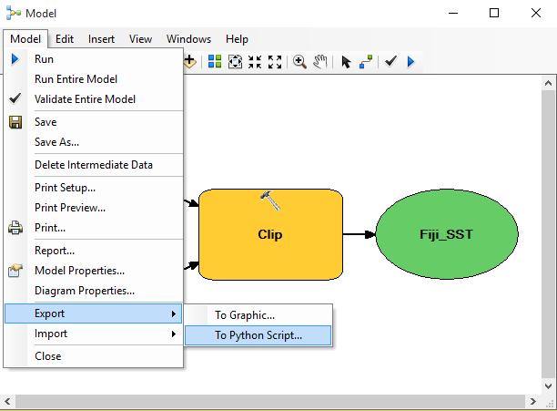
4 Output from ArcGIS Model Builder ArcGIS Model Builder: export python script 4


5 ArcGIS Model Builder: export python script Python script from ArcGIS Model Builder # Import arcpy module import arcpy Import Module # Local variables: infiji_eez = r"c:\temp\fiji_eez.shp insst = r"c:\temp\sst.tif" outfiji_sst = r"c:\temp\fiji_sst.tif" # Process: Clip arcpy.clip_management(sst, #", Fiji_SST, Fiji_EEZ, #", "ClippingGeometry") Assign Import input/output module Process Data 5


6 Output from python script Task: Clip Raster with Polygon [QGIS GUI] 6


![[QGIS]](/docs-images/77/76092504/images/7-3.jpg "Console")


7 Output from QGIS GUI Clip Raster with Polygon [QGIS] Console command generated by QGIS 7
![Clip Raster with Polygon [GDAL] gdalwarp.](/docs-images/77/76092504/images/8-1.jpg "exe dstnodata 0 q cutline C:/temp/EEZs/FJI.")


8 Clip Raster with Polygon [GDAL] gdalwarp.exe dstnodata 0 q cutline C:/temp/EEZs/FJI.shp crop_to_cutline of GTiff C:/temp/SST.tif C:/temp/EEZs/FJI_SST.tif Call executable program Assign nodata value Quiet (no progress reports) Assign clip geometry Write nodata outside clip Assign output format Assign input file Assign output file Python script from GDAL Command # Import arcpy module import os # Local variables: infiji_eez = r"c:\temp\fiji_eez.shp insst = r"c:\temp\sst.tif" outfiji_sst = r"c:\temp\fiji_sst.tif" Import Module Assign Import input/output module # Process: Clip command = ['gdalwarp', ' dstnodata 0', ' cutline', infiji_eez ' crop_to_cutline', ' of GTiff', insst, outfiji_sst] os.system(' '.join(command)) Process Data 8
9 Output from command line Automation of arcpy using python script # Import modules import os # Local variables: shapefolder = r"c:\temp\eezs" sstraster = r"c:\temp\sst.tif # Set workspace arcpy.env.workspace = shapefolder # Process: Clip for ds in arcpy.listfeatureclasses(): outraster = ds.split(.')[0] + "_SST.tif" Import Module Import Assign module input Process list of datasets Assign output arcpy.clip_management(sstraster, "#", outraster, ds, "#", "ClippingGeometry") Process Data Execution time: seconds 9


: if ds.endswith(.")
![shp ): outraster = ds.split(.')[0] + "_SST.](/docs-images/77/76092504/images/10-5.jpg "tif command = ['gdalwarp', ' dstnodata 0', '")


10 Output from automated arcpy python script Automation of GDAL using python script # Import modules import os # Local variables: shapefolder = r"c:\temp\eezs" sstraster = r"c:\temp\sst.tif # Process: Clip for ds in os.listdir(shapefolder): if ds.endswith(.shp ): outraster = ds.split(.')[0] + "_SST.tif command = ['gdalwarp', ' dstnodata 0', ' cutline', infiji_eez ' crop_to_cutline', ' of GTiff', insst, outfiji_sst] os.system(' '.join(command)) Execution time: 20.4 seconds Import Module Import Assign module input Process list of datasets Assign output Process Data 10
11 Output from automated gdal python script Further visualization of spatial data # import modules import arcpy import matplotlib.pyplot as plt import numpy as np # set local variables shapefolder = r"c:\temp\eezs" sstraster = r"c:\temp\sst.tif" rasterlist = [] countrylist = [] # process each shapefile arcpy.env.workspace = shapefolder for ds in arcpy.listfeatureclasses(): outraster = ds.split('.')[0] + "_SST.tif" arcpy.clip_management(sstraster, "#", raster, ds, "#", "ClippingGeometry") array = arcpy.rastertonumpyarray(outraster) rasterlist.append(np.ma.compressed(np.ma.masked_less_equal(array, 0))) countrylist.append(ds.split('.')[0]) # create boxplots fig, ax = plt.subplots() ax.set_ylabel("degrees C", ) bp = plt.boxplot(rasterlist) plt.xticks(np.arange(1, len(countrylist)+1), countrylist, rotation='vertical') plt.title('sst values for each country') plt.show() Import Modules Import Assign module input Create Hold storage data in in memory Process list of datasets Create output rasters Write Hold data in to memory Create boxplot object Create y axis label Add data to boxplots Add x axis label Add title 11


12 Output of python script 12
Using Python with ArcGIS
 Using Python with ArcGIS Jason Pardy (jpardy@esri.com) Esri UC2013. Technical Workshop. Agenda A whirlwind tour Python Essentials Using Python in ArcGIS Python Tools Accessing Data Map Automation ArcGIS
Using Python in ArcGIS Oli Helm May 2, 2013
 Using Python in ArcGIS 10.1 Oli Helm May 2, 2013 ohelm@esri.ca Today s Agenda This seminar is designed to help you understand: 1) Python Essentials 2) What s new in Python in ArcGIS 10.1 3) Python Add-Ins
PYTHON. Scripting for ArcGIS. writeoutput = Inputfc = ar. .ext.{) OUtpUt fc =.. Paul A. Zandbergen. axcpy random. .arcpy, Describe (' is.
 OUtpUt fc =.. Paul A. Zandbergen. axcpy random. .arcpy, Describe (' is.") ' Esri Press REDLANDS CALIFORNIA 'Ti axcpy random From arcpy import env writeoutput = Inputfc = ar OUtpUt fc = I aitcount = int (arcpy,g arcpy, Describe (' st [f = c ~- ist = [] = clesc,oidfrel ext{) r
' Esri Press REDLANDS CALIFORNIA 'Ti axcpy random From arcpy import env writeoutput = Inputfc = ar OUtpUt fc = I aitcount = int (arcpy,g arcpy, Describe (' st [f = c ~- ist = [] = clesc,oidfrel ext{) r
Automated detection and enumeration of marine wildlife using unmanned aircraft systems (UAS) and thermal imagery
 and thermal imagery") Automated detection and enumeration of marine wildlife using unmanned aircraft systems (UAS) and thermal imagery A. C. Seymour 1 *, J. Dale 1, M. Hammill 2, P. N. Halpin 1 and D. W. Johnston 1 1 Division
Automated detection and enumeration of marine wildlife using unmanned aircraft systems (UAS) and thermal imagery A. C. Seymour 1 *, J. Dale 1, M. Hammill 2, P. N. Halpin 1 and D. W. Johnston 1 1 Division
Creating Mosaic Datasets and Publishing Image Services using Python
 Creating Mosaic Datasets and Publishing Image Services using Python Jie Zhang, Jamie Drisdelle Session Offering ID: 305 Overview Introduction to mosaic dataset Raster product for sensor imagery Automatic
Quantum GIS Basic Operations (Wien 2.8) Raster Operations
 Raster Operations") 1 Quantum GIS Basic Operations (Wien 2.8) Raster Operations The QGIS Manual steps through many more basic operations than the following exercise, and will be occasionally be referenced within these NOTE
1 Quantum GIS Basic Operations (Wien 2.8) Raster Operations The QGIS Manual steps through many more basic operations than the following exercise, and will be occasionally be referenced within these NOTE
Python: Getting Started. Ben
 Python: Getting Started Ben Ramseth bramseth@esri.com @esrimapninja E M E R A L D S A P P H I R E T H A N K Y O U T O O UR SPONSORS Topics covered What s is python? Why use python? Basics of python ArcPy
FME / ArcGIS 9 Data Interoperability Extension
 FME / ArcGIS 9 Data Interoperability Extension About us Founded: 1993 Head office: Vancouver, Canada # of Employees: 45 Target markets: GIS & GPS vendors, Telecom and utilities, Oil & gas, Government agencies
8 Querying and Selecting Data
 8 Querying and Selecting Data In this chapter, we will cover the following recipes: ff ff ff ff ff Constructing proper attribute query syntax Creating feature layers and table views Selecting features
Python Getting Started
 2013 Esri International User Conference July 8 12, 2013 San Diego, California Technical Workshop Python Getting Started Drew Flater, Ghislain Prince Esri UC2013. Technical cal Workshop op. Does this describe
Using Python with ArcGIS
 Using Python with ArcGIS Jason Pardy (jpardy@esri.com) Javier Abadia (javier.abadia@esri.es) Esri UC2013. Technical Workshop. Agenda A whirlwind tour Jason: Python Essentials Using Python in ArcGIS Python
ModelBuilder: An Introduction. Kevin Armstrong
 ModelBuilder: An Introduction Kevin Armstrong What is ModelBuilder? A user-friendly way to automate a series of tools Part of the ArcGIS geoprocessing framework - ModelBuilder can run any tool in the ArcToolbox,
Geoprocessing and georeferencing raster data
 Geoprocessing and georeferencing raster data Raster conversion tools Geoprocessing tools ArcCatalog tools ESRI Grid GDB Raster Raster Dataset Raster Catalog Erdas IMAGINE TIFF ArcMap - raster projection
PUG List. Raster Analysis 3D Analysis Geoprocessing. Steve Kopp
 PUG List Raster Analysis 3D Analysis Geoprocessing Steve Kopp Contour Polygons Spatial Analyst - color-filled contours. Similar to thematic classification, where blue = -1000 to zero, and red = 0 to +1000,
Python Getting Started
 Esri European User Conference October 15-17, 2012 Oslo, Norway Hosted by Esri Official Distributor Python Getting Started Jason Pardy Does this describe you? New to Python Comfortable using ArcGIS but
hereby recognizes that Timotej Verbovsek has successfully completed the web course 3D Analysis of Surfaces and Features Using ArcGIS 10
 3D Analysis of Surfaces and Features Using ArcGIS 10 Completed on September 5, 2012 3D Visualization Techniques Using ArcGIS 10 Completed on November 19, 2011 Basics of Map Projections (for ArcGIS 10)
Delineating Watersheds from a Digital Elevation Model (DEM)
") Delineating Watersheds from a Digital Elevation Model (DEM) (Using example from the ESRI virtual campus found at http://training.esri.com/courses/natres/index.cfm?c=153) Download locations for additional
Delineating Watersheds from a Digital Elevation Model (DEM) (Using example from the ESRI virtual campus found at http://training.esri.com/courses/natres/index.cfm?c=153) Download locations for additional
ArcGIS Desktop: Introduction to Geoprocessing with ModelBuilder Kevin Armstrong ESRI
 ArcGIS Desktop: Introduction to Geoprocessing with ModelBuilder Kevin Armstrong ESRI SERUG 2008 1 What is ModelBuilder? A user-friendly way to automate a series of tools Part of the ArcGIS geoprocessing
MATPLOTLIB. Python for computational science November 2012 CINECA.
 MATPLOTLIB Python for computational science 19 21 November 2012 CINECA m.cestari@cineca.it Introduction (1) plotting the data gives us visual feedback in the working process Typical workflow: write a python
ENVI Py for ArcGIS Documentation
 ENVI Py for ArcGIS Documentation Release 1.0 Exelis Visual Information Solutions, Inc. Nov 14, 2017 Contents 1 System Requirements 3 2 Installation and Configuration 5 2.1 ArcMap..................................................
Python: Beyond the Basics. Michael Rhoades
 Python: Beyond the Basics Michael Rhoades Python: Beyond the Basics Synopsis This session is aimed at those with Python experience and who want to learn how to take Python further to solve analytical problems.
Python: Working with Feature Data. Ghislain Prince David Wynne
 Python: Working with Feature Data Ghislain Prince David Wynne Python: Working with Feature Data Cursors Cursors provide record-by-record, feature-by-feature access - Basic necessity for many workflows
Auto/Semi-Automated processing of ENVISAT ASAR imagery of the Arctic Ocean
 Auto/Semi-Automated processing of ENVISAT ASAR imagery of the Arctic Ocean - Explore ArcGIS manual procedure - Implement as a Python script XUELONG cruise during CHINARE-2010 from July 1 Xianmen to Sept
Using Python in ArcGIS Steven Beothy May 28, 2013
 Using Python in ArcGIS 10.1 Steven Beothy sbeothy@esri.ca May 28, 2013 Today s Agenda This seminar is designed to help you understand: 1) Python and how it can be used 2) What s new in Python in ArcGIS
All data is in Universal Transverse Mercator (UTM) Zone 6 projection, and WGS 84 datum.
 Zone 6 projection, and WGS 84 datum.") 111 Mulford Hall, College of Natural Resources, UC Berkeley (510) 643-4539 EXPLORING MOOREA DATA WITH QUANTUM GIS In this exercise, you will be using an open-source FREE GIS software, called Quantum GIS,
111 Mulford Hall, College of Natural Resources, UC Berkeley (510) 643-4539 EXPLORING MOOREA DATA WITH QUANTUM GIS In this exercise, you will be using an open-source FREE GIS software, called Quantum GIS,
The Reference Library Generating Low Confidence Polygons
 GeoCue Support Team In the new ASPRS Positional Accuracy Standards for Digital Geospatial Data, low confidence areas within LIDAR data are defined to be where the bare earth model might not meet the overall
Utility Network Management in ArcGIS: Migrating Your Data to the Utility Network. John Alsup & John Long
 Utility Network Management in ArcGIS: Migrating Your Data to the Utility Network John Alsup & John Long Presentation Outline Utility Network Preparation - Migration Patterns - Understanding the Asset Package
Ex. 4: Locational Editing of The BARC
 Ex. 4: Locational Editing of The BARC Using the BARC for BAER Support Document Updated: April 2010 These exercises are written for ArcGIS 9.x. Some steps may vary slightly if you are working in ArcGIS
Proximity Analysis. Proximity Analysis
 Proximity Analysis Proximity Analysis 1 Ever wonder How close is the nearest gas station? What is the distance between your house and the candy store? What is the shortest route to get to Starbucks? Is
Using Python with ArcGIS
 Using Python with ArcGIS Drew Flater, Nobbir Ahmed Offering 184 Agenda Python essentials Arcpy, functions & classes Script geoprocessing workflows Automate map management & production Customize Desktop
A Practical Guide to Using QGIS
 A Practical Guide to Using QGIS 1.1 INTRODUCTION Quantum GIS (QGIS) is a useful mapping software that enables the compilation and displaying of spatial data in the form of a map. Gaining experience in
Creating Geoprocessing Services and Web Tools. Darren Baird, PE, Esri
 Creating Geoprocessing Services and Web Tools Darren Baird, PE, Esri Introduction Both ArcMap and ArcGIS Pro are covered Terms Geoprocessing Services and Web Tools are the same - ArcMap publishes geoprocessing
Python Raster Analysis. Kevin M. Johnston Nawajish Noman
 Python Raster Analysis Kevin M. Johnston Nawajish Noman Outline Managing rasters and performing analysis with Map Algebra How to access the analysis capability - Demonstration Complex expressions and optimization
You can download missing data from the course website, together with the codes R and python that we will run in this exercise.
 Exercise 4: Samples Characterization Aim: Sampling environmental conditions Principal Component Analysis of environmental conditions Hierarchical clustering of sampling spots Interpretation of the environmental
Python Raster Analysis. Kevin M. Johnston Nawajish Noman
 Python Raster Analysis Kevin M. Johnston Nawajish Noman Outline Managing rasters and performing analysis with Map Algebra How to access the analysis capability - Demonstration Complex expressions and optimization
USING PYTHON WITH ARCGIS ADVANCED LEVEL ONLINE TRAINING GIS. Course. Training. .com
 USING PYTHON WITH ARC ADVANCED LEVEL ONLINE TRAINING TYC Training Course.com COURSE GOALS The course will train students in the advanced use of Python programming language along with Arc Desktop collection
Streamlining Editing Workflows. Amber Bethell
 Streamlining Editing Workflows Amber Bethell Workflow for solving geographic problems Ask a question Create or acquire data Validate and update data Analyze data Create cartographic product Act upon knowledge
Introduction to QGIS
 Introduction to QGIS David Kramar, Ph.D. Minnesota State University Moorhead Department of Anthropology and Earth Science http://www.qgis.org/en/site/ Overview of Workshop What is QGIS? How do I get QGIS
Introduc)on to InVEST ArcGIS Tool
on to InVEST ArcGIS Tool") Introduc)on to InVEST ArcGIS Tool Nasser Olwero GMP, Bangkok April 2-6 2012 Background of tool design Why a tool/arcgis Tool? ArcGIS Geoprocessing Framework 1. Tool dialog 2. Command line 3. Model builder
Introduc)on to InVEST ArcGIS Tool Nasser Olwero GMP, Bangkok April 2-6 2012 Background of tool design Why a tool/arcgis Tool? ArcGIS Geoprocessing Framework 1. Tool dialog 2. Command line 3. Model builder
3D Analysis Tools and Visualization with ArcGIS. Jie Chang Jinwu Ma
 3D Analysis Tools and Visualization with ArcGIS Jie Chang Jinwu Ma Why 3D GIS? Because our world is 3D Improve understanding 3D is easy for everyone to understand Solve 3D problems Some spatial problems
Python: Developing Geoprocessing Tools. David Wynne, Jon Bodamer
 Python: Developing Geoprocessing Tools David Wynne, Jon Bodamer Abstract Join us as we step through the process of creating geoprocessing tools using Python. Using script tools and Python toolboxes as
Python Matplotlib. MACbioIDi February March 2018
 Python Matplotlib MACbioIDi February March 2018 Introduction Matplotlib is a Python 2D plotting library Its origins was emulating the MATLAB graphics commands It makes heavy use of NumPy Objective: Create
Data Interoperability An Introduction
 Data Interoperability An Introduction Bruce Harold Dale Lutz - Esri Inc - Safe Software What is the Data Interoperability Extension? Moving data from app to app ETL in industry jargon If you are not the
Creating a Smaller Data Set from a Larger Data Set Vector Data
 Creating a Smaller Data Set from a Larger Data Set Vector Data Written by Barbara Parmenter, revised by Carolyn Talmadge January 16, 2015 USING THE SELECTION METHOD QUICK METHOD BY CREATING A LAYER FILE...
Working with Feature Layers. Russell Brennan Gary MacDougall
 Working with Feature Layers Russell Brennan Gary MacDougall Working with Feature Layers Session will focus on feature access and editing Highlight new features added over the last few releases Agenda Introduction
What s New for Developers in ArcGIS Maura Daffern October 16
 What s New for Developers in ArcGIS 10.1 Maura Daffern October 16 mdaffern@esri.ca Today s Agenda This seminar is designed to help you understand: 1) Using Python to increase productivity 2) Overview of
PYTHON: BUILDING GEOPROCESSING TOOLS. David Wynne, Andrew Ortego
 PYTHON: BUILDING GEOPROCESSING TOOLS David Wynne, Andrew Ortego http://esriurl.com/creatingtools http://esriurl.com/creatingtoolspro Today Putting it together Source code Validation Parameters Best Practices
Parallel Python: Multiprocessing With ArcPy. Clinton Dow Geoprocessing Neeraj Rajasekar Spatial Analyst
 Parallel Python: Multiprocessing With ArcPy Clinton Dow Geoprocessing Neeraj Rajasekar Spatial Analyst Agenda What Multiprocessing Is What Multiprocessing Is Not Demo of Multiprocessing Modules - Multiprocessing
Using the Geodatabase
 Using the Geodatabase February 13, 2002 Presented by: John Stroud, ESRI GeoDatabase Geodatabase comes in two flavors Personal mdb format ArcSDE rdbms format ArcGIS is a suite of three products ArcView,
Python: Building Geoprocessing Tools
 FedGIS Conference February 13 14, 2017 Washington, DC Python: Building Geoprocessing Tools Michael Rhoades Frank Orr Why we build geoprocessing tools Your work becomes part of the geoprocessing framework
Training courses. Course Overview Details Audience Duration. Applying GIS
 Training courses (Last update: December 2017) Remarks: As part of a course a certificate is issued for each attendee. All software used during the courses is Open Source Software. Contact: allspatial Geospatial
Python - Raster Analysis
 Esri International User Conference San Diego, California Technical Workshops July 2012 Python - Raster Analysis Kevin M. Johnston Ryan DeBruyn The problem that is being addressed You have a complex modeling
Managing and Serving Elevation and Lidar Data. Cody Benkelman UC 2018
 Managing and Serving Elevation and Lidar Data Cody Benkelman UC 2018 Outline Usage Modes Data Management - Architecture - Workflow Automation for Repeatability & Scalability A few options Usage Modes of
A GIS add-in for automated measurement of sand dune migration using multi-temporal and high-resolution digital elevation models.
 A GIS add-in for automated measurement of sand dune migration using multi-temporal and high-resolution digital elevation models User s Guide Please send comments/suggestions to: Pinliang Dong 1155 Union
Arcgis 10 Manually Move Labels
 Arcgis 10 Manually Move Labels The "easy custom labeling" Tool in QGIS seems to come close to the ArcGIS solution. However, after I created my custom label layer I am not able to move my labels at the
QGIS Tutorials Documentation
 QGIS Tutorials Documentation Release 0.1 Nathaniel Roth November 30, 2016 Contents 1 Installation 3 1.1 Basic Installation............................................. 3 1.2 Advanced Installation..........................................
Exercise 3: Creating a Geodatabase
 Exercise 3: Creating a Geodatabase Introduction: A database (DB) is an organized collection of data, that we can visualize as being a group of tables. An example of a simple database can be seen below:
Stacey Maples GIS Specialist and Instruction Coordinator, Yale University Map Department
 WHAT S NEW IN ARC CGIS 10-5 THINGS YOU SHOUL LD KNOW! (OK, THERE S ACTUALLY MORE THAN 5 HERE) Stacey Maples GIS Specialist and Instruction Coordinator, Yale University Map Department stacey.maples@yale.edu
Building Geoprocessing Tools with Python: Beyond the Basics. Dave Wynne
 Building Geoprocessing Tools with Python: Beyond the Basics Dave Wynne Building Geoprocessing Tools with Python: Getting Started Subhead Here This session will focus on creating polished, well-designed
4. Once open, activate the ArcToolbox window (if not already visible) by clicking the red box below
 by clicking the red box below") Getting Started Downloading The latest version of the toolbox is available for download at: www.sdmtoolbox.org. This software requires ArcMap 10.1 10.5 with an active Spatial Analyst license (www.esri.com).
Getting Started Downloading The latest version of the toolbox is available for download at: www.sdmtoolbox.org. This software requires ArcMap 10.1 10.5 with an active Spatial Analyst license (www.esri.com).
ArcGIS Export to Circuitscape Instructions
 ArcGIS Export to Circuitscape Instructions This tool will export ArcGIS vector and raster data into ASCII rasters, suitable for analysis in Circuitscape (see http://www.circuitscape.org). Circuitscape
ArcMap - EXPLORING THE DATABASE Part I. SPATIAL DATA FORMATS Part II
 Week 5 ArcMap - EXPLORING THE DATABASE Part I SPATIAL DATA FORMATS Part II topics of the week Exploring the Database More on the Table of Contents Exploration tools Identify, Find, Measure, Map tips, Hyperlink,
An Introduction to Data Interoperability
 Esri International User Conference San Diego, California 2012 Technical Workshops July 24/25 An Introduction to Data Interoperability Bruce Harold - Esri Dale Lutz Safe Software Background Why Data Interoperability?
Priming the Pump Stage II
 Priming the Pump Stage II Modeling and mapping concentration with fire response networks By Mike Price, Entrada/San Juan, Inc. The article Priming the Pump Preparing data for concentration modeling with
Working With Raster Data Using Python. Nawajish Noman Ryan DeBruyn
 Working With Raster Data Using Python Nawajish Noman Ryan DeBruyn Outline Managing rasters with tools and performing analysis with Map Algebra How to access the analysis capability - Demonstration Complex
Lesson 8 : How to Create a Distance from a Water Layer
 Created By: Lane Carter Advisor: Paul Evangelista Date: July 2011 Software: ArcGIS 10 Lesson 8 : How to Create a Distance from a Water Layer Background This tutorial will cover the basic processes involved
file:///c:/users/c_harmak/appdata/local/temp/arc8f36/tmp308d.tmp.htm
 Page 1 of 6 FireDistricts_CoB Shapefile Tags Bradenton, boundary, fire districts Summary The best current representation of the City of Bradenton Florida's fire districts and sub-districts. Description
CSTools Guide (for ArcGIS version 10.2 and 10.3)
") CSTools Guide (for ArcGIS version 10.2 and 10.3) 1. Why to use Orientation Analysis and Cross section tools (CSTools) in ArcGIS? 2 2. Data format 2 2.1 Coordinate Systems 2 3. How to get the tools into
CSTools Guide (for ArcGIS version 10.2 and 10.3) 1. Why to use Orientation Analysis and Cross section tools (CSTools) in ArcGIS? 2 2. Data format 2 2.1 Coordinate Systems 2 3. How to get the tools into
Lab 9. Raster Analyses. Tomislav Sapic GIS Technologist Faculty of Natural Resources Management Lakehead University
 Lab 9 Raster Analyses Tomislav Sapic GIS Technologist Faculty of Natural Resources Management Lakehead University How to Interpolate Surface Turn on the Spatial Analyst extension: Tools > Extensions >
You start model builder through the Geoprocessing > ModelBuilder command:
 ESPM5295 ModelBuilder 1 ModelBuilder Automate Processing ModelBuilder is an ArcMap application that you can use to create processing workflows and tools. You can create something like a flowchart on a
Exercise 1: Getting to know ArcGIS
 The Scenario You are working for the California Visitor s Commission. You have been asked to prepare a map of California for several dignitaries from out of the country. Your map will need to include enough
Data Assembly, Part II. GIS Cyberinfrastructure Module Day 4
 Data Assembly, Part II GIS Cyberinfrastructure Module Day 4 Objectives Continuation of effective troubleshooting Create shapefiles for analysis with buffers, union, and dissolve functions Calculate polygon
ii. From the Tools menu choose Multi-Extract
 Created By: Grant J. Firl Advisors: Paul Evangelista, Jim Graham Date: November 2010 Software: ArcGIS v9.2, TUGZip v3.5 Lesson 8: Mosaicking and Clipping Landsat Data The purpose of this tutorial is to
ArcPy Introductory Tutorial
 ArcPy Introductory Tutorial Nick Eubank May 28, 2014 Contents 1 Introduction: What is ArcPy? 1 2 Scripting in ArcPy by Copy-Paste 4 3 Scripting Directly in ArcPy 6 4 Good Hygiene 7 5 Style 7 6 Editing
How to perform a quality check of a new dataset. QGIS Tutorials and Tips
 How to perform a quality check of a new dataset QGIS Tutorials and Tips ZanSea zansea@suza.ac.tz 1 Objective GIS datasets can come from many different sources: From a Website. From a USB key given by a
GRASS. Geographic Resources Analysis Support System Current versions. Related software
 GRASS Geographic Resources Analysis Support System http://grass.osgeo.org Current versions 6.3 stable (old) 6.4 next stable (new) 7 development (future) Related software QGIS http://qgis.org GRASS Capabilities
ArcGIS Desktop The Road Ahead. Amadea Azerki
 ArcGIS Desktop The Road Ahead Amadea Azerki Agenda An Overview of ArcGIS 10 Desktop Enhancements User Interface Mapping Editing Analysis Sharing Q & A ArcGIS 10 Overview Focuses on Usability and Productivity
Key Terms. Attribute join Target table Join table Spatial join
 Key Terms Attribute join Target table Join table Spatial join Lect 10A Building Geodatabase Create a new file geodatabase Map x,y data Convert shape files to geodatabase feature classes Spatial Data Formats
Designing and Using Cached Map Services
 Esri International User Conference San Diego, California Technical Workshops July 2012 Designing and Using Cached Map Services Sterling Quinn Eric Rodenberg What we will cover Session Topics - Map cache
Lecture 12 Programming for automation of common data management tasks
 Lecture 12 Programming for automation of common data management tasks Daniel P. Ames Hydroinformatics Fall 2012 This work was funded by National Science Foundation Grant EPS Goals this Week To learn the
Stream Network and Watershed Delineation using Spatial Analyst Hydrology Tools
 Stream Network and Watershed Delineation using Spatial Analyst Hydrology Tools Prepared by Venkatesh Merwade School of Civil Engineering, Purdue University vmerwade@purdue.edu January 2018 Objective The
Setting Up and Deploying Geospatial Data Shares Using the QGIS Server Application
 Setting Up and Deploying Geospatial Data Shares Using the QGIS Server Application Donald L. Schrupp Wildlife Ecologist Colorado Division of Wildlife (retired) Quantum GIS (QGIS) Applications QGIS is not
Basic Tasks in ArcGIS 10.3.x
 Basic Tasks in ArcGIS 10.3.x This guide provides instructions for performing a few basic tasks in ArcGIS 10.3.1, such as adding data to a map document, viewing and changing coordinate system information,
Python Raster Analysis
 2013 Esri International User Conference July 8 12, 2013 San Diego, California Technical Workshop Python Raster Analysis Kevin M. Johnston Ryan DeBruyn Nawajish Noman Esri UC2013. Technical Workshop. The
Setup Guide for Op Tracker
 Setup Guide for Op Tracker Contents 1 Welcome to Op Tracker... 2 2 Data Overview... 3 2.1 Block Boundary Feature Layer... 3 2.2 Block Tracking Feature Layer... 3 2.3 Ancillary Data Feature Layer... 3 2.4
Name: Date: June 27th, 2011 GIS Boot Camps For Educators Lecture_3
 Name: Date: June 27th, 2011 GIS Boot Camps For Educators Lecture_3 Practical: Creating and Editing Shapefiles Using Straight, AutoComplete and Cut Polygon Tools Use ArcCatalog to copy data files from:
Prerequisites and Dependencies GRAIP-2 assumes a Windows Computer with ArcGIS or higher and Microsoft Office.
 GRAIP-2 for ArcGIS 10 Installation and Use David Tarboton, Pabitra Dash May 2016 Last updated:5/3/2016 This document describes how to install and use the ArgGIS 10 toolbox developed for GRAIP-2. GRAIP-2
Providing Interoperability Using the Open GeoServices REST Specification
 2013 Esri International User Conference July 8 12, 2013 San Diego, California Technical Workshop Providing Interoperability Using the Open GeoServices REST Specification Satish Sankaran Kevin Sigwart What
ArcGIS Online: Managing Data. Jeremy Bartley Sentha Sivabalan
 ArcGIS Online: Managing Data Jeremy Bartley (jbartley@esri.com) Sentha Sivabalan (ssivabalan@esri.com) Agenda Creating and managing content like Apps, Maps, Scenes and Layers in ArcGIS Today s Topics:
Visualisation in python (with Matplotlib)
") Visualisation in python (with Matplotlib) Thanks to all contributors: Ag Stephens, Stephen Pascoe. Introducing Matplotlib Matplotlib is a python 2D plotting library which produces publication quality figures
Visualisation in python (with Matplotlib) Thanks to all contributors: Ag Stephens, Stephen Pascoe. Introducing Matplotlib Matplotlib is a python 2D plotting library which produces publication quality figures
Zonal Statistics in PostGIS a Tutorial
 2014 Brian J McGill. You are welcome to link to this tutorial but not copy or repost. Feedback is welcome and should be sent to mail AT brianmcgill DOT org Zonal Statistics in PostGIS a Tutorial Zonal
INTRODUCTION TO DATA VISUALIZATION WITH PYTHON. Working with 2D arrays
 INTRODUCTION TO DATA VISUALIZATION WITH PYTHON Working with 2D arrays Reminder: NumPy arrays Homogeneous in type Calculations all at once Indexing with brackets: A[index] for 1D array A[index0, index1]
Creating Python Scripts for ArcGIS STUDENT EDITION
 Creating Python Scripts for ArcGIS STUDENT EDITION Copyright 2018 Esri All rights reserved. Course version 1.2. Version release date August 2018. Printed in the United States of America. The information
Lab 1: Introduction to ArcGIS
 Lab 1: Introduction to ArcGIS Objectives In this lab you will: 1) Learn the basics of the software package we will be using for the remainder of the semester, and 2) Discover the role that climate and
HOW TO USE THE WEBGIS
 HOW TO USE THE WEBGIS Note: the guide was written by taking as main reference the official documentation by Lizmap, which is the web service used to publish QGIS project onine http://docs.3liz.com/en/user_guide.html
Esri UC2013. Technical Workshop. Type Presentation Name Here
 Type Presentation Name Here 2013 Esri International User Conference July 8 12, 2013 San Diego, California Technical Workshop 3D Analyst An Introduction Deepinder Deol Michael Contreras Why use 3D GIS?
Python: Working with Raster Data
 Esri Developer Summit March 8 11, 2016 Palm Springs, CA Python: Working with Raster Data Nawajish Noman Elizabeth Graham Outline Managing rasters with tools and performing analysis with Map Algebra How
Starting the QGIS Program. Exercise 1: Exploring QGIS
 Exercise 1: Exploring QGIS In this exercise you will learn how to open maps, manipulate layers, add spatial data, change symbols, and navigate within QGIS. You will also learn to repair broken data links.
The Data Journalist Chapter 7 tutorial Geocoding in ArcGIS Desktop
 The Data Journalist Chapter 7 tutorial Geocoding in ArcGIS Desktop Summary: In many cases, online geocoding services are all you will need to convert addresses and other location data into geographic data.
Combine Yield Data From Combine to Contour Map Ag Leader
 Combine Yield Data From Combine to Contour Map Ag Leader Exporting the Yield Data Using SMS Program 1. Data format On Hard Drive. 2. Start program SMS Basic. a. In the File menu choose Open. b. Click on