Introduction to QGIS
|
|
|
- Adam Gibbs
- 6 years ago
- Views:
Transcription

1 Introduction to QGIS David Kramar, Ph.D. Minnesota State University Moorhead Department of Anthropology and Earth Science

2 Overview of Workshop What is QGIS? How do I get QGIS The QGIS GUI Basic Geoprocessing Additional Plugins Saga, Grass, and R The Print Composer

3 What is QGIS? In short It is a flexible, capable, and powerful open source solution! QGIS started as a viewing environment for Linux, But integrates with Windows and Mac. Supports MANY data formats and works well with PostGreSQL and PostGIS layers.


4 What is QGIS? Open Source and Powerful All basic, and most advanced GIS functionality Supports a plethora of data formats Extendable and Highly customizable Includes comprehensive Analytic capabilities e.g. Processing Tools and Modeler Can be customized and automated via: Python scritpting Supports plug-in and user interface development Rapid Development from community!!
5 The Open Source Culture In many cases, business folks do not understand why some people would Create something useful and then just give it away. For that reason, open source software solutions are often viewed as less robust, less functional, and less compatible. That could not be further from the truth. The OS culture is a way of doing things, of working together. It is a culture. It is generally assumed that if you are using the software, you will give back to the community via Support pages, new plug-ins, customizations, etc. The more people work together, the stronger the community becomes.

6 How do I get QGIS? download.html Most current version is QGIS 2.18: Las Palmas Download the installer and GO!! Note: There was an issue with Python from the ArcGIS 10.4 Install that created issues with QGIS. That appears to be resolved with 10.5

7 The Graphic User Interface

8


9
10 Most of the buttons/toolbars are self-explanatory if you are familiar with other GIS packages, however some are not as intuitive as we may like..best is to just explore them. Project Toolbar Map Navigation Toolbar Labeling Toolbar Digitizing Toolbar Attributes Toolbar Manage Layers Toolbar Advanced Digitizing Toolbar

11 Setting Up Project Properties

12 Setting Up Project Properties

13 Setting Up Vector Layer Properties - General


14 Setting Up Vector Layer Properties - Symbology Units can be millimeters, Map Units, or Map Pixels


15 Setting Up Vector Layer Properties - Symbology In general Symbology is a shortcoming when compared to ArcGIS, which can make the cartography portion of GIS a bit exhausting. With that being said, there is a plugin called Resource Sharing that expands the basic symbol sets in QGIS. While I still argue that symbol sets are limited compared to ArcGIS, they are getting better all the time. To access them, change the symbology type from simple marker to.. And then browse to your symbol sets.

16 Setting Up Vector Layer Properties - Labels
17 Setting Up Vector Layer Properties - Fields


18 Setting Up Vector Layer Properties - Fields

19 Setting Up Vector Layer Properties - Rendering

20 Setting Up Vector Layer Properties - Rendering
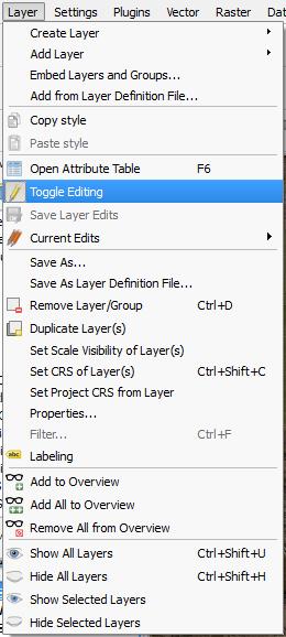
21 Calculating Attribute Values and Working with Tables Not as intuitive as calculating in ArcMap. Fields can be added via the Attribute Table, or through the Field Calculator. You can Create New, Update Existing, or Create Virtual Fields (Field Calculator) MUST be in Edit Mode to add a field Simple enough: Just toggle Editing on or off. Two ways to view attribute data: Table View, or Form View.
 Toggle Editing Either Add Field First, or open Field Calculator and Add through that")
22 Calculating Attribute Values and Working with Tables To calculate area (in the CRS the layer is in): Open Attribute Table (Lakes for this example) Toggle Editing Either Add Field First, or open Field Calculator and Add through that Dialog.
 Toggle Editing Either Add Field First, or open Field Calculator and Add through that")
23 Calculating Attribute Values and Working with Tables To calculate area (in the CRS the layer is in): Open Attribute Table (Lakes for this example) Toggle Editing Either Add Field First, or open Field Calculator and Add through that Dialog.

24 Calculating Attribute Values and Working with Tables To calculate area (in the CRS the layer is in): Open Attribute Table (Lakes for this example) Toggle Editing Either Add Field First, or open Field Calculator and Add through that Dialog. Perimeter is calculated in much the same fashion. To convert to something other than meters, just Include that in the calculation. For example If CRS units are meters: $AREA / = KM

25 Calculating Attribute Values and Working with Tables To calculate area (in the CRS the layer is in): Open Attribute Table (Lakes for this example) Toggle Editing Either Add Field First, or open Field Calculator and Add through that Dialog. Perimeter is calculated in much the same fashion. To convert to something other than meters, just Include that in the calculation. For example If CRS units are meters: $AREA / = SQ KM Similarly for Perimeter: $PERIMETER / 1000 = KM
 Fields and Values Dropdown Double click fields and build")
26 Calculating Attribute Values and Working with Tables To calculate based on OTHER FIELDS: Add a Field (Compactness) Fields and Values Dropdown Double click fields and build expression.

27 Joining Tables in QGIS To Join tables based on common fields: Joins are completed from the Layer Properties Dialog. Not that dissimilar from ArcGIS. Specify the Join Layer and Join Field, and then Specify the Target Field So: Click + Button to Add a Join

 Specify Whether to Keep Only Matching Create Virtual layer, or Real")
28 Spatial Joins in QGIS To create a spatial join: Vector Data Management Tools Join Attributes By Location Select Target Vector Layer Select Join Vector Layer Select Geometric Predicate Specify Type of Attribute Summary Specify Statistics to compute (Optional) Specify Whether to Keep Only Matching Create Virtual layer, or Real Layer?


29 Geoprocessing, Research, Analysis Tools in QGIS GeoProcessing Options are Similar to ArcMap: Research Tools: Analysis Tools: Geometry Tools:
30 Expanding Vector Processing in QGIS The Processing Toolbox: There is no shortage of vector based analysis tools in the processing toolbox. In some respects there are many of the same types of operations that can be found in ArcGIS. When fully integrated with GRASS and R, however, there are many more statistical based operators. Same is true for Raster Operations.

31 Expanding Vector Processing in QGIS Working with Plugins: If for some reason you cannot find what you are looking for in the standard Processing Plugin, there are a number of resources via the Plugin Manager. Clicking on any PlugIn will give you an overview of the Plugin functionality.


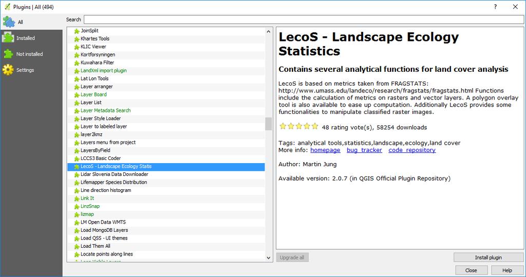
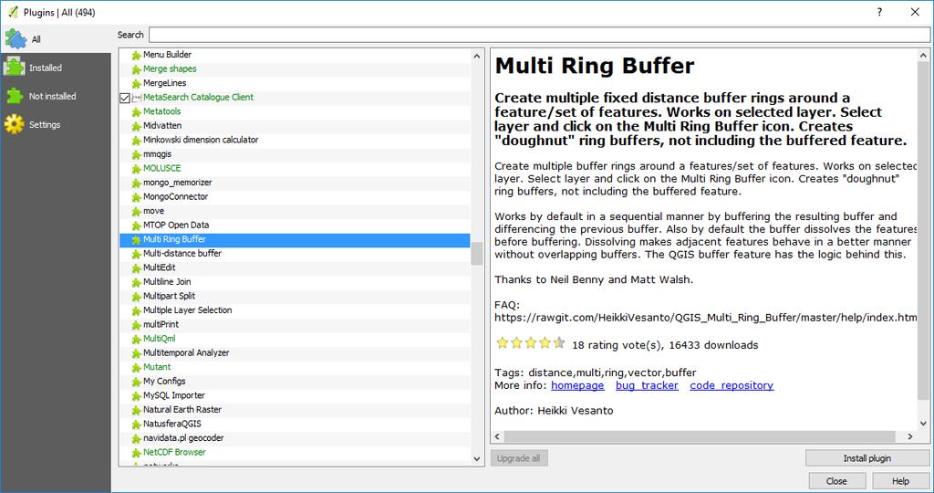

32 Expanding Vector Processing in QGIS
33 Managing your Raster Data There are a number of different ways to manage your raster data in QGIS. Most typical options are found in the Raster Menu Item we discussed earlier. For example to build raster pyramids, you would go to Raster Miscellaneous Build Overviews (Pyramids). To Merge rasters you go to Raster Miscellaneous Merge Additional Raster Operations are found in the processing toolbox plugin.
34 QGIS + R Package (Statistical Software) Official R webpage and download links R Studio Articles AND Scripts - R + Geospatial use Geospatial data in R and Beyond R, an Integrated Statistical Programming Environment and GIS Spatial data and R QGIS-R-Geostatistics scripts contribution R scripts and GIS integration R-scripts in Processing "Spatial data processing framework for QGIS" Plug-in (formerly Sextante plug-in) Needs to be enabled in Processing menu / providers: After R is enabled (and installed on your operating system) you can run the scripts from the Processing Toolbox see next page


35 QGIS Processing Toolbox Enabling R Package (Statistical Software)

36 QGIS Processing Toolbox Enabling R Package (Statistical Software) The first thing you have to do is to tell QGIS where your R binaries are located. You can do this using the R folder entry in the processing configuration dialog. Once you have set that parameter, you can start creating and executing your own R scripts. On my computer, they are located at: C:\Program Files\R\R-3.3.1
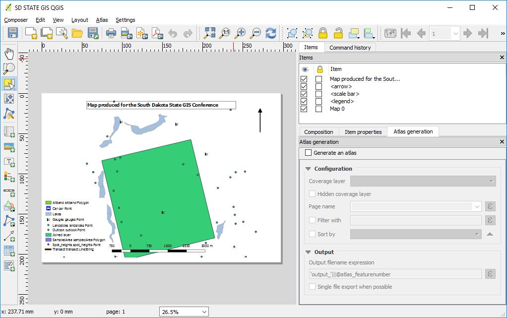
37 The QGIS Print Composer Making Maps in QGIS is a little different than in ArcGIS. There is no Toggle between layout and data view. To access: Project New Print Composer What is the first thing you notice??
38 The QGIS Print Composer Making Maps in QGIS is a little different than in ArcGIS. There is no Toggle between layout and data view. To access: Project New Print Composer What is the first thing you notice?? No Map!! You have to add the map: Layout Add Map No Dynamic Zoom in/out. You MUST get your extent set in the browser and THEN add it to the composer. See Example.. Accessing Item Properties is a bit different To remove Items from legend you can t just Turn it off in the Browser. Lacks the dynamic flexibility if you are used to ArcGIS, but does other neat things.
39

40 To re-center content, use the Move Content Option.

41 Select Map Adjust Scale HERE to zoom in or out
 object from the Items panel. In the Item properties tab, scroll down to the Overviews section. Click the Add a new overview button.")
42 One neat feature of the Print Composer is that it can automatically highlight the area from the main map which is represented in our inset. Select the Map 0 (main map) object from the Items panel. In the Item properties tab, scroll down to the Overviews section. Click the Add a new overview button. Select Map1 for your Map Frame option..

43 Adding North Arrows isn t as straightforward as you might think. To add one you need to go to Layout Add Image. Under Item Properties, find the Search Directories Option. There are a number of nice North Arrows to choose from.
44 The QGIS Print Composer
45 The QGIS Print Composer Many Options!
46 Resources QGIS - Joining Tables tutorial: QGIS - Building a Map Atlas tutorial: QGIS Topology step-by-step tutorial: QGIS - Grass integration - two options: Using the Processing Plug-in (Spatial data processing framework for QGIS) is easy to use Using the Grass plugin - has more functions but is more difficult to use
47 Resources QGIS Tutorials: Current User Guide: Documents Creating Maps in QGIS: QGIS 2.8 User Guide QGIS 2.8 QGIS Training Manual PyQGIS developer cookbook Tere are TONS of youtube videos out there as well.
Low Cost and Free Public Health Mapping Tools
 Low Cost and Free Public Health Mapping Tools Quantum GIS - QGIS 1) Download and Install a) QGIS can be quickly and easily installed on Windows, Macs and Linux from installers found here: http://hub.qgis.org/projects/quantum-gis/wiki/download
Introduction to using QGIS for Archaeology and History Workshop by the Empirical Reasoning Center
 Introduction to using QGIS for Archaeology and History Workshop by the Empirical Reasoning Center In this workshop, we will cover the basics of working with spatial data, as well as its main uses for archaeology.
All data is in Universal Transverse Mercator (UTM) Zone 6 projection, and WGS 84 datum.
 Zone 6 projection, and WGS 84 datum.") 111 Mulford Hall, College of Natural Resources, UC Berkeley (510) 643-4539 EXPLORING MOOREA DATA WITH QUANTUM GIS In this exercise, you will be using an open-source FREE GIS software, called Quantum GIS,
111 Mulford Hall, College of Natural Resources, UC Berkeley (510) 643-4539 EXPLORING MOOREA DATA WITH QUANTUM GIS In this exercise, you will be using an open-source FREE GIS software, called Quantum GIS,
LAB 1: Introduction to ArcGIS 8
 LAB 1: Introduction to ArcGIS 8 Outline Introduction Purpose Lab Basics o About the Computers o About the software o Additional information Data ArcGIS Applications o Starting ArcGIS o o o Conclusion To
QGIS Tutorials Documentation
 QGIS Tutorials Documentation Release 0.1 Nathaniel Roth November 30, 2016 Contents 1 Installation 3 1.1 Basic Installation............................................. 3 1.2 Advanced Installation..........................................
A Practical Guide to Using QGIS
 A Practical Guide to Using QGIS 1.1 INTRODUCTION Quantum GIS (QGIS) is a useful mapping software that enables the compilation and displaying of spatial data in the form of a map. Gaining experience in
Making a Sackville Coastal Flood Map
 Making a Sackville Coastal Flood Map Demo covers: Accessing and previewing map templates Modifying map elements such as titles, data frames, legends & scale bars Drawing a graphic on a map Adding text
Geographical Information Systems Institute. Center for Geographic Analysis, Harvard University. LAB EXERCISE 1: Basic Mapping in ArcMap
 Harvard University Introduction to ArcMap Geographical Information Systems Institute Center for Geographic Analysis, Harvard University LAB EXERCISE 1: Basic Mapping in ArcMap Individual files (lab instructions,
Getting Started with GIS using ArcGIS 10.6 What is GIS? and - Module 1 Creating a map document
 Getting Started with GIS using ArcGIS 10.6 What is GIS? and - Module 1 Creating a map document Marcel Fortin Map & Data Library mdl@library.utoronto.ca 2018 http://mdl.library.utoronto.ca This workshop
GRASS. Geographic Resources Analysis Support System Current versions. Related software
 GRASS Geographic Resources Analysis Support System http://grass.osgeo.org Current versions 6.3 stable (old) 6.4 next stable (new) 7 development (future) Related software QGIS http://qgis.org GRASS Capabilities
Review of File Management and Introduction to ArcGIS
 Review of File Management and Introduction to ArcGIS RNR/GEOG 417/517 Overview of Presentation Discuss the objectives of the lab exercise Introduce the class directory structure General file policies Introduce
Geographic Information Systems. using QGIS
 Geographic Information Systems using QGIS 1 - INTRODUCTION Generalities A GIS (Geographic Information System) consists of: -Computer hardware -Computer software - Digital Data Generalities GIS softwares
Basic Tasks in ArcGIS 10.3.x
 Basic Tasks in ArcGIS 10.3.x This guide provides instructions for performing a few basic tasks in ArcGIS 10.3.1, such as adding data to a map document, viewing and changing coordinate system information,
SEXTANTE, a free platform for geospatial analysis
 SEXTANTE, a free platform for geospatial analysis Olaya, Victor May 20, 2009 1 Introduction The SEXTANTE project 1 aims to create a platform for the development of geoalgorithms that makes it easy both
GGR 375 QGIS Tutorial
 GGR 375 QGIS Tutorial With text taken from: Sherman, Gary E. Shuffling Quantum GIS into the Open Source GIS Stack. Free and Open Source Software for Geospatial (FOSS4G) Conference. 2007. Available online
Intro to GIS (requirements: basic Windows computer skills and a flash drive)
") Introduction to GIS Intro to GIS (requirements: basic Windows computer skills and a flash drive) Part 1. What is GIS. 1. System: hardware (computers, devices), software (proprietary or free), people. 2.
Introduction to GIS Intro to GIS (requirements: basic Windows computer skills and a flash drive) Part 1. What is GIS. 1. System: hardware (computers, devices), software (proprietary or free), people. 2.
QGIS Workshop Su Zhang and Laura Gleasner 11/10/2016. QGIS Workshop
 1. Introduction to Quantum GIS (QGIS) QGIS Workshop QGIS is a free and open source Geographic Information System (GIS). QGIS can help you create, edit, visualize, and publish geospatial information on
Lesson 2 Installing and Using Quantum GIS (QGIS)
") Lesson 2 Installing and Using Quantum GIS (QGIS) Use file Explorer to open County QGIS portable hard drive provided. The program execute (.exe) will be at the bottom of the list. Double click on the file.
Lesson 2 Installing and Using Quantum GIS (QGIS) Use file Explorer to open County QGIS portable hard drive provided. The program execute (.exe) will be at the bottom of the list. Double click on the file.
Exercise 3-1: Soil property mapping
 Exercise 3-1: Soil property mapping Mapping objectives: Create a soil analysis point layer from tabular data in QGIS Create a continuous surface soil property map using Kriging Interpolation in SAGA GIS
Map Preparation. Using QGIS
 Map Preparation Using QGIS Tutorial ID: IGET_GIS_006 This tutorial has been developed by BVIEER as part of the IGET web portal intended to provide easy access to geospatial education. This tutorial is
Geological mapping using open
 Geological mapping using open source QGIS MOHSEN ALSHAGHDARI -2017- Abstract Geological mapping is very important to display your field work in a map for geologist and others, many geologists face problems
Tutorial 1 Exploring ArcGIS
 Tutorial 1 Exploring ArcGIS Before beginning this tutorial, you should make sure your GIS network folder is mapped on the computer you are using. Please refer to the How to map your GIS server folder as
Lesson 8 : How to Create a Distance from a Water Layer
 Created By: Lane Carter Advisor: Paul Evangelista Date: July 2011 Software: ArcGIS 10 Lesson 8 : How to Create a Distance from a Water Layer Background This tutorial will cover the basic processes involved
Segmentation Guide using open source resources By Paul Russell, Ana Carolina Fiorini, and Trevor Caughlin
 Segmentation Guide using open source resources By Paul Russell, Ana Carolina Fiorini, and Trevor Caughlin This guide aims to give you a step by step guidance to digitize tree cover in google earth using
Working with demographic grids in QGIS
 Working with demographic grids in QGIS Anna Dmowska dmowska@amu.edu.pl April 2017 1. Introduction SocScape (Social Landscape) is a research project which provides open access to high resolution (30 m)
Raster: The Other GIS Data
 Raster_The_Other_GIS_Data.Docx Page 1 of 11 Raster: The Other GIS Data Objectives Understand the raster format and how it is used to model continuous geographic phenomena. Understand how projections &
Using GIS to Site Minimal Excavation Helicopter Landings
 Using GIS to Site Minimal Excavation Helicopter Landings The objective of this analysis is to develop a suitability map for aid in locating helicopter landings in mountainous terrain. The tutorial uses
Juniata County, Pennsylvania
 GIS Parcel Viewer Web Mapping Application Functional Documentation June 21, 2017 Juniata County, Pennsylvania Presented by www.worldviewsolutions.com (804) 767-1870 (phone) (804) 545-0792 (fax) 115 South
QGIS Workshop Su Zhang and Laura Gleasner 11/15/2018. QGIS Workshop
 1. Introduction to QGIS QGIS Workshop QGIS is a free and open source Geographic Information System (GIS). QGIS can help users create, edit, visualize, analyze, and publish geospatial information on various
Working with Elevation Data URPL 969 Applied GIS Workshop: Rethinking New Orleans After Hurricane Katrina Spring 2006
 Working with Elevation Data URPL 969 Applied GIS Workshop: Rethinking New Orleans After Hurricane Katrina Spring 2006 This GIS lab exercise will explore Light Detection And Ranging (LiDAR) data for New
Step by Step GIS. Section 1
 Step by Step GIS Section 1 Contact the web page given below for the data required to do the exercises (http://www.pasda.psu.edu/default.asp) Before beginning the tutorials please visit the Preparation
Getting Started With LP360
 Getting Started With LP360 12/22/2015 1 Contents What is LP360?... 3 System Requirements... 3 Installing LP360... 4 How to Enable the LP360 Extension... 4 How to Display the LP360 Toolbar... 4 How to Import
GY301 Geomorphology Lab 5 Topographic Map: Final GIS Map Construction
 GY301 Geomorphology Lab 5 Topographic Map: Final GIS Map Construction Introduction This document describes how to take the data collected with the total station for the campus topographic map project and
THE HONG KONG POLYTECHNIC UNIVERSITY DEPARTMENT OF LAND SURVEYING & GEO-INFORMATICS LSGI521 PRINCIPLES OF GIS
 THE HONG KONG POLYTECHNIC UNIVERSITY DEPARTMENT OF LAND SURVEYING & GEO-INFORMATICS LSGI521 PRINCIPLES OF GIS Student name: Student ID: Table of Content Working with files, folders, various software and
I CALCULATIONS WITHIN AN ATTRIBUTE TABLE
 Geology & Geophysics REU GPS/GIS 1-day workshop handout #4: Working with data in ArcGIS You will create a raster DEM by interpolating contour data, create a shaded relief image, and pull data out of the
Answer the following general questions: 1. What happens when you right click on an icon on your desktop? When you left double click on an icon?
 Name: Date: June 27th, 2011 GIS Boot Camps For Educators Practical: Explore ArcGIS 10 Desktop Tools and functionality Day_1 Lecture 1 Sources: o ArcGIS Desktop help o ESRI website o Getting to Know ArcGIS
What s New in Desktop 10.1
 What s New in Desktop 10.1 Damian Spangrud Esri Redlands Trip Down Memory Lane ArcGIS A Complete System for Geographic Information Cloud Web Online Mobile Enterprise Desktop Sharing Information sharing
Introduction to QGIS: Student Workbook
 2016 Introduction to QGIS: Student Workbook Created by: MARK DE BLOIS, CEO / FOUNDER, UPANDE LIMITED WITH SUPPORT FROM THE WORLD BANK AND THE UK DEPARTMENT FOR INTERNATIONAL DEVELOPMENT (DFID) Module 3:
Objective: To be come more familiar with some more advanced applications in ArcGIS.
 Advanced Procedures in ArcGIS 2005 SPACE Workshop OSU Author: Jason VanHorn Purpose: Having gone through Getting to know ArcGIS, you are now ready to do some more advanced applications. In this lab you
STUDENT PAGES GIS Tutorial Treasure in the Treasure State
 STUDENT PAGES GIS Tutorial Treasure in the Treasure State Copyright 2015 Bear Trust International GIS Tutorial 1 Exercise 1: Make a Hand Drawn Map of the School Yard and Playground Your teacher will provide
Exercise 1: Getting to know ArcGIS
 The Scenario You are working for the California Visitor s Commission. You have been asked to prepare a map of California for several dignitaries from out of the country. Your map will need to include enough
GIS Intro for G&G 304
 Geog_And_Epid.Doc Page 1 of 21 GIS Intro for G&G 304 Objectives By the end of this tutorial, you should understand: How to Open spatial data in ArcMap How to create a spatial data layer from tabular coordinates
Explore some of the new functionality in ArcMap 10
 Explore some of the new functionality in ArcMap 10 Scenario In this exercise, imagine you are a GIS analyst working for Old Dominion University. Construction will begin shortly on renovation of the new
Introduction to QGIS: Instructor s Notes
 2016 Introduction to QGIS: Instructor s Notes Created by: MARK DE BLOIS, CEO / FOUNDER, UPANDE LIMITED WITH SUPPORT FROM THE WORLD BANK AND THE UK DEPARTMENT FOR INTERNATIONAL DEVELOPMENT (DFID) Module
Migrating from ArcMap to ArcGIS Pro. David Watkins Scott Noulis
 Migrating from ArcMap to ArcGIS Pro David Watkins Scott Noulis Getting Started with ArcGIS Pro ArcGIS Pro 64 bit, multi-threaded Simplified user interface Integrated with the ArcGIS platform Combined 2D/3D
Exercise 1: An Overview of ArcMap and ArcCatalog
 Exercise 1: An Overview of ArcMap and ArcCatalog Introduction: ArcGIS is an integrated collection of GIS software products for building a complete GIS. ArcGIS enables users to deploy GIS functionality
INTRODUCTION TO GIS WORKSHOP EXERCISE
 111 Mulford Hall, College of Natural Resources, UC Berkeley (510) 643-4539 INTRODUCTION TO GIS WORKSHOP EXERCISE This exercise is a survey of some GIS and spatial analysis tools for ecological and natural
Introduction to GIS & Mapping: ArcGIS Desktop
 Introduction to GIS & Mapping: ArcGIS Desktop Your task in this exercise is to determine the best place to build a mixed use facility in Hudson County, NJ. In order to revitalize the community and take
Ex. 4: Locational Editing of The BARC
 Ex. 4: Locational Editing of The BARC Using the BARC for BAER Support Document Updated: April 2010 These exercises are written for ArcGIS 9.x. Some steps may vary slightly if you are working in ArcGIS
The ArcMap Interface and Using Basic ArcMap Analysis Tools to Create a Map
 The ArcMap Interface and Using Basic ArcMap Analysis Tools to Create a Map *You will need a computer with ESRI ArcGIS Desktop version 9.3 or higher installed* Data Download 1. Save the zipped folder with
دورة تدريبية عن تطبيقات برنامج ARC GIS
 دورة تدريبية عن تطبيقات برنامج ARC GIS مايو 2009 دورة تدريبيت عن تطبيقاث برنامج ARC GIS 2009 مايو Table of Contents Introduction... viii Module 1: Introduction to ArcGIS 9 Module Objectives... 1-1 ArcGIS
Boundless Desktop Documentation
 Boundless Desktop Documentation Release 1.0.0 Boundless Sep 20, 2017 Contents 1 What is Boundless Desktop? 1 2 System requirements 3 2.1 Windows system requirements......................................
HOW TO USE THE WEBGIS
 HOW TO USE THE WEBGIS Note: the guide was written by taking as main reference the official documentation by Lizmap, which is the web service used to publish QGIS project onine http://docs.3liz.com/en/user_guide.html
Launch QGIS. Launch QGIS from. Open window Quantum GIS (Figure 1.1 below) Start All Programs Quantum GIS. QGISIcon on the desk top
 Start All Programs Quantum GIS. QGISIcon on the desk top") QGIS Launch QGIS Launch QGIS from Start All Programs Quantum GIS OR QGISIcon on the desk top Open window Quantum GIS (Figure 1.1 below) 2 Figure 1.1 3 Opening Raster For this exercise we demonstrate three
QGIS Launch QGIS Launch QGIS from Start All Programs Quantum GIS OR QGISIcon on the desk top Open window Quantum GIS (Figure 1.1 below) 2 Figure 1.1 3 Opening Raster For this exercise we demonstrate three
Getting to Know ModelBuilder
 Getting to Know ModelBuilder Offered by Shane Bradt through the UNH Cooperative Extension Geospatial Technologies Training Center Developed by Sandy Prisloe and Cary Chadwick at the Geospatial Technology
Advanced PDF features
 1 of 7 2/17/2009 10:56 PM Show Navigation Hide Navigation You are here: Mapping and v isualization > Page layout and map composition > Map output Advanced PDF features Release 9.3 Last modified November
Encoded URLs in hyperlinks. TerraGo Publisher for ArcGIS TerraGo Publisher for ArcGIS Server TerraGo Arc2Edge Version 7.3.
 TerraGo Publisher for ArcGIS TerraGo Publisher for ArcGIS Server TerraGo Arc2Edge Version 7.3.1, December 2017 What is TerraGo Publisher for ArcGIS? What is TerraGo Arc2Edge? What s new in this release?
CHAPTER TWO QUICKSTART. Projects and Session Files. Layers and Map Compositions CHAPTER TWO QUICKSTART 5
 CHAPTER TWO QUICKSTART Projects and Session Files Projects are an organizing concept throughout TerrSet. Projects contain folders which in turn contain files. Projects are similar to the concept of a geodatabase
Lab Assignment 4 Basics of ArcGIS Server. Due Date: 01/19/2012
 Lab Assignment 4 Basics of ArcGIS Server Due Date: 01/19/2012 Overview This lab assignment is designed to help you develop a good understanding about the basics of ArcGIS Server and how it works. You will
GST 101: Introduction to Geospatial Technology Lab 2 - Spatial Data Models
 GST 101: Introduction to Geospatial Technology Lab 2 - Spatial Data Models Objective Explore and Understand Spatial Data Models Document Version: 3/3/2015 FOSS4G Lab Author: Kurt Menke, GISP Bird's Eye
Making Maps in Quantum GIS
 Making Maps in Quantum GIS Author Attribution Major contributors to this curriculum include (alphabetical): Maria Fernandez Michael Hamel Quentin Lewis Maili Page James Peters Charlie Schweik Alexander
SPATIAL DESIGN NETWORK ANALYSIS sdna in QGIS
 SPATIAL DESIGN NETWORK ANALYSIS sdna in QGIS 1 Installing sdna+ as plugin for QGIS... 2 1.1 Download & Install sdna... 2 1.2 Setting up sdna in QGIS... 3 1.3 Open the sdna toolbox... 5 2 sdna in QGIS Processing
CONTENTS 1 INTRODUCTION 3 ARCGIS 5 START ARCMAP 11 IMPORT 1: MAP DATA 12 ADD WIND FARM DATA 21 CREATE A MAP TO INSERT IN A REPORT 32
 CONTENTS CONTENTS 1 INTRODUCTION 3 SCENARIO 3 WHAT WILL I LEARN? 3 WHAT DATA DO I HAVE? 4 ARCGIS 5 ARCMAP 6 ARCCATALOG 8 ARCTOOLBOX 9 START ARCMAP 11 IMPORT 1:250000 MAP DATA 12 CREATE A GROUP LAYER 16
George Mason University Department of Civil, Environmental and Infrastructure Engineering
 George Mason University Department of Civil, Environmental and Infrastructure Engineering Dr. Celso Ferreira Prepared by Lora Baumgartner December 2015 Revised by Brian Ross July 2016 Exercise Topic: GIS
GY461 GIS 1: Environmental Campus Topography Project with ArcGIS 9.x
 I. Introduction GY461 GIS 1: Environmental In this project you will use data from a topographic survey of the USA campus to generate 2 separate maps: 1. A color-coded 2-dimensional topographic contour
Lab 3: Digitizing in ArcGIS Pro
 Lab 3: Digitizing in ArcGIS Pro What You ll Learn: In this Lab you ll be introduced to basic digitizing techniques using ArcGIS Pro. You should read Chapter 4 in the GIS Fundamentals textbook before starting
A Second Look at DEM s
 A Second Look at DEM s Overview Detailed topographic data is available for the U.S. from several sources and in several formats. Perhaps the most readily available and easy to use is the National Elevation
Quantum GIS (QGIS) Basics: India
 Basics: India") Quantum GIS (QGIS) Basics: India Written by Barbara Parmenter and Irina Rasputnis, updated by Carolyn Talmadge, Aishwarya Venkat, and Kyle M. on March 6, 2017 INTRODUCTION... 1 STARTING QGIS AND ADDING
Quantum GIS (QGIS) Basics: India Written by Barbara Parmenter and Irina Rasputnis, updated by Carolyn Talmadge, Aishwarya Venkat, and Kyle M. on March 6, 2017 INTRODUCTION... 1 STARTING QGIS AND ADDING
Geography 281 Mapmaking with GIS Project One: Exploring the ArcMap Environment
 Geography 281 Mapmaking with GIS Project One: Exploring the ArcMap Environment This activity is designed to introduce you to the Geography Lab and to the ArcMap software within the lab environment. Before
Viewing the Data 3 Turning Layers On / Off 4 Navigation Toolbar 5 Layout Toolbar 7 Identify Tool 8 Find Tool 10 Measure Tool 12 Go To XY Tool 14
 1 Viewing the Data 3 Turning Layers On / Off 4 Navigation Toolbar 5 Layout Toolbar 7 Identify Tool 8 Find Tool 10 Measure Tool 12 Go To XY Tool 14 Transparency Tool 16 Markup Tools 19 ArcMap Markup Tools
Priming the Pump Stage II
 Priming the Pump Stage II Modeling and mapping concentration with fire response networks By Mike Price, Entrada/San Juan, Inc. The article Priming the Pump Preparing data for concentration modeling with
Mid-West ESRI Utility User s Group Conference. March 26, 2014
 Mid-West ESRI Utility User s Group Conference March 26, 2014 Presented by: Hillary Bjorstrom, GIS Analyst STAR Energy Services LLC 1 What are Data Driven Pages? Data Driven Pages Workflow Creating an Index
START>PROGRAMS>ARCGIS>
 Department of Urban Studies and Planning Spring 2006 Department of Architecture Site and Urban Systems Planning 11.304J / 4.255J GIS EXERCISE 2 Objectives: To generate the following maps using ArcGIS Software:
In order to follow this set of directions you will need the following
 How to Create Maps & Figures in ArcView 9x In order to follow this set of directions you will need the following 1) the Jenny s Louisiana GIS Instructional CD 2) a computer with ArcGIS on it (version 9.0
Who are we? Randal Hale. Nathan Saylor. GIS Coordinator for Hardin Co. Owner of North River Geographic Systems. Consultant. Owner of Saylor Mapping
 Who are we? Nathan Saylor Randal Hale GIS Coordinator for Hardin Co. Owner of North River Geographic Systems Owner of Saylor Mapping Consultant Been doing GIS since 2005 Been in the GIS Industry 20 something
Tutorial 1: Finding and Displaying Spatial Data Using ArcGIS
 Tutorial 1: Finding and Displaying Spatial Data Using ArcGIS This tutorial will introduce you to the following: Websites where you may browse to find geospatial information Identifying spatial data, usable
Modern Tools for NTDs Control Programmes
 Modern Tools for NTDs Control Programmes www.thiswormyworld.org Practical 1 Becoming familiar with QGIS interface and GIS features www.thiswormyworld.org 2 Aim of practical This first practical aims to
Data Assembly, Part II. GIS Cyberinfrastructure Module Day 4
 Data Assembly, Part II GIS Cyberinfrastructure Module Day 4 Objectives Continuation of effective troubleshooting Create shapefiles for analysis with buffers, union, and dissolve functions Calculate polygon
Measuring Area/Length of Organisms with GIS
 Measuring Area/Length of Organisms with GIS These instructions enable you to measure the length and area of microscopic organisms in ArcGIS from digital photographs. The four-step process involves: georeferencing
ArcGIS Viewer for Microsoft Silverlight An Introduction
 Esri International User Conference San Diego, CA Technical Workshops July 12, 2011 ArcGIS Viewer for Microsoft Silverlight An Introduction Art Haddad, Rich Zwaap, and Derek Law Agenda Background Product
Lab 1: Exploring ArcMap and ArcCatalog In this lab, you will explore the ArcGIS applications ArcCatalog and ArcMap. You will learn how to use
 Lab 1: Exploring ArcMap and ArcCatalog In this lab, you will explore the ArcGIS applications ArcCatalog and ArcMap. You will learn how to use ArcCatalog to find maps and data and how to display maps in
GIS Basics for Urban Studies
 GIS Basics for Urban Studies Date: March 21, 2018 Contacts: Mehdi Aminipouri, Graduate Peer GIS Faciliator, SFU Library (maminipo@sfu.ca) Keshav Mukunda, GIS & Map Librarian Librarian for Geography (kmukunda@sfu.ca)
Creating a Smaller Data Set from a Larger Data Set Vector Data
 Creating a Smaller Data Set from a Larger Data Set Vector Data Written by Barbara Parmenter, revised by Carolyn Talmadge January 16, 2015 USING THE SELECTION METHOD QUICK METHOD BY CREATING A LAYER FILE...
QGIS for Geoscientists
 QGIS for Geoscientists Robin Armit, Tom Carmichael, Lachlan Grose Monash Structural Geophysics group 22 nd 26th February 2016 GIS A geographic information system (GIS) is a system designed to capture,
WA L KT H R O U G H 1
 WA L KT H R O U G H 1 udig Install and Introduction 08 June 2008 TABLE OF CONTENTS 1Goals...3 2Installing and Running The udig Application...4 3Online Documentation and Tutorials...8 3.1Help Categories...9
Lab 1: Landuse and Hydrology, learning ArcGIS
 Lab 1: Landuse and Hydrology, learning ArcGIS The following lab exercises are designed to give you experience using ArcMap in order to visualize and analyze datasets that are relevant to important geomorphological/
Working with Attribute Data and Clipping Spatial Data. Determining Land Use and Ownership Patterns associated with Streams.
 GIS LAB 3 Working with Attribute Data and Clipping Spatial Data. Determining Land Use and Ownership Patterns associated with Streams. One of the primary goals of this course is to give you some hands-on
City of La Crosse Online Mapping Website Help Document
 City of La Crosse Online Mapping Website Help Document This document was created to assist in using the new City of La Crosse online mapping sites. When the website is first opened, a map showing the City
INTERACTIVE MAP TUTORIAL
 Wisconsin Breeding Bird Atlas II INTERACTIVE MAP TUTORIAL General Information There are two versions of the map, the PC Desktop Version, and the Mobile/Mac Version. Most of this guide will assume you are
Working with Events in ArcGIS 8.2
 Working with Events in ArcGIS 8.2 This tutorial is a companion to the article, Understanding Dynamic Segmentation: Working with Events in ArcGIS in the October December 2002 issue of ArcUser magazine.
Converting AutoCAD Map 2002 Projects to ArcGIS
 Introduction This document outlines the procedures necessary for converting an AutoCAD Map drawing containing topologies to ArcGIS version 9.x and higher. This includes the export of polygon and network
Data for this exercise are located in the L1 subdirectory or the class web page. Videos for this exercise are located in the class web page.
 Lesson 1: What You ll Learn: -Start ArcMap -Create a new map -Add data layers -Pan and zoom -Change data symbology -Change display properties -Set relative paths -Add layers to features -Select data -Measure
Installing the Toolkit
 Installing the Toolkit The Toolkit is an ArcGIS Add-in that is compatible with ArcGIS 10.0 and above. Please see the Toolkit website (http://www.fs.fed.us/eng/rsac/programs/teui/about.html) for previous
GIS LAB 8. Raster Data Applications Watershed Delineation
 GIS LAB 8 Raster Data Applications Watershed Delineation This lab will require you to further your familiarity with raster data structures and the Spatial Analyst. The data for this lab are drawn from
Bharath Setturu Research scholar, EWRG, Center for Ecological Sciences, IISc, Bangalore & EWRG-CES IIIT-HYDERABAD
 Bharath Setturu Research scholar, EWRG, Center for Ecological Sciences, IISc, Bangalore settur@ces.iisc.ernet.in & IIIT-HYDERABAD Introduction to QGIS oquantum GIS (QGIS) is a GIS tool for managing geographical
Tutorial 9: Creating Layout Plans and Printing
 Tutorial 9: Creating Layout Plans and Printing Tutorial Content 9.1. What is the layout view and how is this different to the data view? 9.2. How do I set out a map for printing in ArcMap? 9.3. What tools
Chapter 5. Presenting Data
 Chapter 5. Presenting Data Copyright McGraw-Hill Education. Permission required for reproduction or display. 5-1 Map Design Process 5-2 1 About ArcGIS Chapter 5. Presenting Data 5-3 Page layouts and map
Create a personal geodatabase
 Create a personal geodatabase To create a personal geodatabase that corresponds to the same release as the ArcGIS for Desktop client you are using, follow these steps: 1. In ArcCatalog, right-click the
USING DATA DRIVEN PAGES
 USING DATA DRIVEN PAGES Mid-West ESRI Utility User s Group Conference March 26, 2014 Presented by: Hillary Bjorstrom, GIS Analyst STAR Energy Services LLC Alexandria, Minnesota EXERCISE 1 CREATING A GRID
Advanced Map Layout Options - Extent Indicators
 Advanced Map Layout Options - Extent Indicators Article ID : TT100050 Software : ArcGIS Desktop 10 Platform : Windows XP, Windows Vista, Windows 7 Date : 12 th June, 2012 Introduction Extent indicators