3D Analysis Tools and Visualization with ArcGIS. Jie Chang Jinwu Ma
|
|
|
- Ann Green
- 6 years ago
- Views:
Transcription


1 3D Analysis Tools and Visualization with ArcGIS Jie Chang Jinwu Ma


2 Why 3D GIS? Because our world is 3D Improve understanding 3D is easy for everyone to understand Solve 3D problems Some spatial problems can only be solved in 3D Better communication 3D makes it easier to articulate ideas


3 What can you do with ArcGIS 3D? Multiscale 3D Models 3D Geodesign ArcGIS for 3D Cities Surface modeling Share 3D scenes Native lidar support Integrated 3D 3D Analysis

 3D Geoprocessing - Data processing - Surface")
4 Contents What is 3D Analyst? 3D Visualization - ArcGlobe - ArcScene - 3D Symbology, 3D Editing, Animation - Demo (ArcGlobe) - ArcGIS Pro - Demo (ArcGIS Pro) 3D Geoprocessing - Data processing - Surface analysis - Feature-oriented tools - Demo
5 What is 3D Analyst? ArcGIS extension that provides capabilities for: Interactive 3D Visualization of spatial data 3D Editing of feature data 3D Geoprocessing tools Publish globe services (ArcGIS Server) Publish globe documents (Publisher toolbar) for use in ArcReader Export ArcScene documents to 3D web scenes
6 Data Types Vector features Points, lines, polygons, and multipatches Surface types Triangular Irregular Networks (TINs) Raster surfaces Terrain datasets LAS datasets (LASD)

7 ArcGlobe 3D visualization application Data placed on 3D globe Map like & oblique views Integrated topography One logical globe surface One multi-resolution mesh Caching Disk cache and memory cache Levels-of-detail (raster data)


8 ArcGlobe: Levels-of-detail Far (less detail) Near (more detail)

9 ArcScene 3D visualization application Memory based application Better for smaller study areas Export to 3D web scene (.3ws)
 Swipe tool (ArcGlobe only) Flicker tool (ArcGlobe only)")
10 3D Effects Toolbar Real-time feedback for Transparency Front/backface culling Lighting Depth priority (ArcScene only) Swipe tool (ArcGlobe only) Flicker tool (ArcGlobe only)


11 3D Symbology Applied to feature data Add realism to your documents Match to symbols in style
12 3D Styles Points - 3D Geometric primitives: Spheres, Cones, etc. - 3D Models: Street furniture, Houses, etc. - 3D Character Markers - Import 3D models Lines - OpenFlight (*.flt), 3DS Max (*.3ds), Virtual Reality Markup Language (*.vrml), and SketchUp (*.skp), Collada (*.dae) models - 3D Texture Line Symbols: Pavement, Concrete, etc. - 3D Geometric primitives (ArcScene): Tube, Strip, Wall etc. Polygons - 3D Texture Fill Symbols: grass texture...


13 3D Editing Feature editing in ArcGlobe and ArcScene Template based editing Support for snapping
14 3D Graphics and KML support 3D Graphics Toolbar Digitize points, lines, polygons and text graphics Apply 3D Symbology to the graphic elements Keyhole MarkUp Language (ArcGlobe only) Add KML data using the KML toolbar in ArcGlobe

15 Animation Tools
16 Customization framework Customization environments - C#, VB.NET, Java, etc. GlobeControl and SceneControl - Used in custom applications - Can easily view existing documents
17 Demo - ArcGlobe
 Geoprocessing tools Share Customize - SDK for Microsoft.")
18 ArcGIS Pro 64-bit desktop application Multithreaded processing New graphics engine Modern user interface Visualize, design, edit (2D/3D) Geoprocessing tools Share Customize - SDK for Microsoft.NET - ArcPy
19 Demo ArcGIS Pro

20 Why 3D Analyst? Visualize Data, 2D and 3D Surface Creation & Analysis 3D Operators and Visibility Tools Conversions Type Presentation Title Here
")


21 What Is a Surface? Functional Surface - f(x) = ax + b - Z = a + bx + cy Raster Surface TIN Surface - Triangulated Irregular Network Terrain Las Dataset TIN/Terrain Raster Surface Type Presentation Title Here


22 Why GeoProcessing? Prepare data for visualization and analysis Performing surface & visibility analysis Batch/non-interative data processing Type Presentation Title Here


23 Host Applications Desktop applications - ArcCatalog - ArcMap - ArcScene - ArcGlobe ArcGIS Server - As GP services ArcGIS Pro - All in one! Type Presentation Title Here

 gp.checkoutextension (\"3D\") gp.")
24 Different Ways to Run GP Tools How are they used? - Graphical user interface - Command line mode - Model Builder - Scripting Type Presentation Title Here Python: import arcgisscripting gp = arcgisscripting.create() gp.checkoutextension ("3D") gp.workspace = "C:/UC09" gp.toolbox = "3D" gp.createtin_3d ("MyTin4")


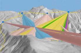
25 Categorization of 3D GP Tools How are they organized? Toolbox - Toolset Subset 3D Analyst Tools Toolbox 1. Data conversion/preparation - Text/binary files, Feature classes, Rasters, TIN-based data 2. Surface creation - Raster interpolation, TIN/Terrain/LASD creation 3. Surface analysis - Aspect/slope, Contour, Feature interpolation 4. 3D operator & visibility - Intersect3D, Skyline, Intervisibility, and Sun Shadow analysis Type Presentation Title Here


26 Task Levels Level of GP tasks (from high to low) - UI/Model - Command line/scripting - ArcObjects Example: Creating a TIN Surface 1. Using the 3D Analyst Toolbar, done by end users 2. Using GP tools, done by power end users 3. Using ArcObjects, done by customization developers Dim pdoc As IMxDocument: Set pdoc = ThisDocument Dim penv As Ienvelope: Set penv = pdoc.activatedview.fullextent Dim ptinedit As ITinEdit: Set ptinedit = New Tin 3 ptinedit.initnew penv: ptinedit.saveas "C:\temp\myTin ptinedit.addfromfeatureclass 2 1 Python: >>> import arcpy >>> arcpy.ddd.import3dfiles("d:/data/boeing747.3ds", "D:/data/mydata.gdb/boeing747") Type Presentation Title Here


27 Demos Surface analysis primer - Common tasks - Surface types User interface - 3D Analyst Toolbar - 3D GP Toolbox Sample tools 1. CreateTIN and EditTIN TIN surface creation 2. LineOfSight linear visibility analysis 3. Viewshed areal visibility analysis on raster 4. Interactive Profile cross sections 5. Skyline suite of tools Type Presentation Title Here
28 3D Analyst Geo-Processing Summary Prepare data for 3D visualization and surface analysis - Creating Surface - Surface Analysis - Conversion - 3D Feature and Visibility Provide a way for processing data on the UI or on batch mode - Application UI as Geo-Processing Tool Dialog - Command Line or Python Scripting - Model Builder Sample Tool Demo Type Presentation Title Here


29 Please Take Our Survey on the Esri Events App! Download the Esri Events app and find your event Select the session you attended Scroll down to find the survey Complete Answers and Select Submit


30
Esri UC2013. Technical Workshop. Type Presentation Name Here
 Type Presentation Name Here 2013 Esri International User Conference July 8 12, 2013 San Diego, California Technical Workshop 3D Analyst An Introduction Deepinder Deol Michael Contreras Why use 3D GIS?
From 2D to 3D at Esri
 From 2D to 3D at Esri OGC/EuroSDR workshop on CityGML in National Mapping Paul Hardy phardy@esri.com Business Development Consultant National Mapping & Cadastre Esri 3D GIS Visualize Manage Share Analyze
Contents What is 3D Mapping Creating g the 3D Dataset Ingredients of a 3D Virtual City Publishing 3D Globes The Road ahead Questions and Answers
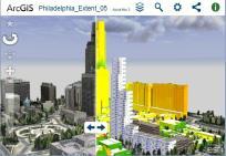
 Creating a 3D Virtual City Using ArcGIS Tamrat Belayneh Hardeep Bajwa Contents What is 3D Mapping Creating g the 3D Dataset Ingredients of a 3D Virtual City Publishing 3D Globes The Road ahead Questions
Creating, managing and utilizing a 3D Virtual City in ArcGIS Tamrat Belayneh Eric Wittner
 Creating, managing and utilizing a 3D Virtual City in ArcGIS 10.1 Tamrat Belayneh (tbelayneh@esri.com) Eric Wittner (ewittner@esri.com ) Contents 3D Mapping & Ingredients of a 3D Virtual City Creating
Visualization with ArcGlobe. Brady Hoak
 Visualization with ArcGlobe Brady Hoak Contents What is ArcGlobe? 3D Mapping and ArcGlobe Displaying data in ArcGlobe ArcGlobe tools Tips for constructing ArcGlobe documents New at ArcGIS 9.3 ArcGIS integration
3D Data Modelling at Esri. Paul Hardy Business Development Consultant Esri Europe
 3D Data Modelling at Esri Paul Hardy phardy@esri.com Business Development Consultant Esri Europe Users of 3D GIS Local government Facilities management Civil engineering 3D GIS Defense / Public Safety
From 2D to 3D at Esri
 From 2D to 3D at Esri Paul Hardy, Esri Inc phardy@esri.com, Cambridge, UK SHORT PAPER This short paper provides an overview of the 3D capabilities of a modern GIS, illustrated by the Esri ArcGIS system,
3D Analyst Visualization with ArcGlobe. Brady Hoak, ESRI DC
 3D Analyst Visualization with ArcGlobe Brady Hoak, ESRI DC 3D GIS Viewing geospatial data in 3D leads to new insights 2D 3D Sometimes you need to edit your data in 3D 2D 3D Some problems can only be solved
Sharing 3D Content on the Web
 Sharing 3D Content on the Web Nathan Shephard, Gert van Maren Why 3D GIS? Because our world is 3D Improve understanding 3D is easy for everyone to understand Better communication 3D makes it easier to
GEOGRAPHIC INFORMATION SYSTEMS Lecture 25: 3D Analyst
 GEOGRAPHIC INFORMATION SYSTEMS Lecture 25: 3D Analyst 3D Analyst - 3D Analyst is an ArcGIS extension designed to work with TIN data (triangulated irregular network) - many of the tools in 3D Analyst also
Surface Analysis with 3D Analyst
 2013 Esri International User Conference July 8 12, 2013 San Diego, California Technical Workshop Surface Analysis with 3D Analyst Khalid H. Duri Esri UC2013. Technical Workshop. Why use 3D GIS? Because
Lidar Working with LAS Datasets
 2013 Esri International User Conference July 8 12, 2013 San Diego, California Technical Workshop Lidar Working with LAS Datasets Raghav Vemula (3D Team) Esri UC2013. Technical Workshop. Agenda Las Dataset
Introduction to 3D Analysis. Jinwu Ma Jie Chang Khalid Duri
 Introduction to 3D Analysis Jinwu Ma Jie Chang Khalid Duri Area & Volume 3D Analyst Features Detect Change Determine Cut/Fill Calculate Surface Area & Volume Data Management Data Creation Data Conversion
PUG List. Raster Analysis 3D Analysis Geoprocessing. Steve Kopp
 PUG List Raster Analysis 3D Analysis Geoprocessing Steve Kopp Contour Polygons Spatial Analyst - color-filled contours. Similar to thematic classification, where blue = -1000 to zero, and red = 0 to +1000,
What s New in Desktop 10.1
 What s New in Desktop 10.1 Damian Spangrud Esri Redlands Trip Down Memory Lane ArcGIS A Complete System for Geographic Information Cloud Web Online Mobile Enterprise Desktop Sharing Information sharing
Cartographic Techniques and Representations
 Cartographic Techniques and Representations NEARC 2007 ESRI Technical Session ESRI, Boston Overview of Presentation Labeling and Annotation Masking Layout Tips Cartographic Representations Labeling versus
COPYRIGHTED MATERIAL. Introduction to 3D Data: Modeling with ArcGIS 3D Analyst and Google Earth CHAPTER 1
 CHAPTER 1 Introduction to 3D Data: Modeling with ArcGIS 3D Analyst and Google Earth Introduction to 3D Data is a self - study tutorial workbook that teaches you how to create data and maps with ESRI s
hereby recognizes that Timotej Verbovsek has successfully completed the web course 3D Analysis of Surfaces and Features Using ArcGIS 10
 3D Analysis of Surfaces and Features Using ArcGIS 10 Completed on September 5, 2012 3D Visualization Techniques Using ArcGIS 10 Completed on November 19, 2011 Basics of Map Projections (for ArcGIS 10)
Exporting ArcScene to 3D Web Scenes. Documents. An Esri White Paper November 2013
 Exporting ArcScene to 3D Web Scenes Documents An Esri White Paper November 2013 Copyright 2013 Esri All rights reserved. Printed in the United States of America. The information contained in this document
ArcGIS Desktop The Road Ahead. Amadea Azerki
 ArcGIS Desktop The Road Ahead Amadea Azerki Agenda An Overview of ArcGIS 10 Desktop Enhancements User Interface Mapping Editing Analysis Sharing Q & A ArcGIS 10 Overview Focuses on Usability and Productivity
Developers Road Map to ArcGIS Desktop and ArcGIS Engine
 Developers Road Map to ArcGIS Desktop and ArcGIS Engine Core ArcObjects Desktop Team ESRI Developer Summit 2008 1 Agenda Dev Summit ArcGIS Developer Opportunities Desktop 9.3 SDK Engine 9.3 SDK Explorer
Your Prioritized List. Priority 1 Faulted gridding and contouring. Priority 2 Geoprocessing. Priority 3 Raster format
 Your Prioritized List Priority 1 Faulted gridding and contouring Priority 2 Geoprocessing Priority 3 Raster format Priority 4 Raster Catalogs and SDE Priority 5 Expanded 3D Functionality Priority 1 Faulted
ArcGIS Pro: What s New in Editing and Data Management
 Federal GIS Conference February 9 10, 2015 Washington, DC ArcGIS Pro: What s New in Editing and Data Management Robert LeClair ArcGIS Pro Overview Esri FedUC 2015 Technical Workshop ArcGIS Pro: What's
Managing Lidar and Photogrammetric Point Clouds. Lindsay Weitz Cody Benkelman
 and Photogrammetric Point Clouds Lindsay Weitz Cody Benkelman Presentation Context What is lidar, and how does it work? Not this presentation! What can you do with lidar in ArcGIS? What does Esri recommend
ArcGIS Pro: Mapping & Visualization. David Watkins, Edie Punt &
 ArcGIS Pro: Mapping & Visualization David Watkins, Edie Punt & Craig Williams @daviddwatkins, @epunt, & @williamscraigm Mapping an Visualization Vision In ArcGIS Pro Improve drawing performance and quality
ArcGIS Pro Terminology Guide
 ArcGIS Pro Terminology Guide Essential Terminology or Functionality That s New to ArcGIS Pro ArcGIS Pro Project Map Scene Ribbon Tab on the ribbon View Active view Pane Gallery Task Quick Access Toolbar
ArcGIS Pro Terminology Guide
 ArcGIS Pro Terminology Guide Sharing Terminology and User Interface Cross-Reference Share content Project package (.ppkx) Map package (.mpkx) Layer package (.lpkx) Share or publish a web layer Share Web
Data Interoperability An Introduction
 Data Interoperability An Introduction Bruce Harold Dale Lutz - Esri Inc - Safe Software What is the Data Interoperability Extension? Moving data from app to app ETL in industry jargon If you are not the
Using VBA and ArcMap to Create and Export 3D Buildings
 Using VBA and ArcMap to Create and Export 3D Buildings Abstract Brian Bradshaw Layers in ArcScene containing polygon features can be extruded to create 3D blocks for display in the current scene. While
An Introduction to Using Lidar with ArcGIS and 3D Analyst
 FedGIS Conference February 24 25, 2016 Washington, DC An Introduction to Using Lidar with ArcGIS and 3D Analyst Jim Michel Outline Lidar Intro Lidar Management Las files Laz, zlas, conversion tools Las
Working with Feature Layers. Russell Brennan Gary MacDougall
 Working with Feature Layers Russell Brennan Gary MacDougall Working with Feature Layers Session will focus on feature access and editing Highlight new features added over the last few releases Agenda Introduction
What s s Coming in ArcGIS 10 Desktop
 What s s Coming in ArcGIS 10 Desktop Damian Spangrud ArcGIS Product Manager, ESRI dspangrud@esri.com (or at least turn to silent) ArcGIS 10 A Simple & Pervasive System for Using Maps & Geographic Information
ArcGIS GeoEvent Server: Making 3D Scenes Come Alive with Real-Time Data
 ArcGIS GeoEvent Server: Making 3D Scenes Come Alive with Real-Time Data Morakot Pilouk, Ph.D. Senior Software Developer, Esri mpilouk@esri.com @mpesri Agenda 1 2 3 4 5 6 3D for ArcGIS Real-Time GIS Static
3D in the Browser with WebGL. Chris Andrews 3D Product Manager Javier Gutierrez 3D Product Engineer
 3D in the Browser with WebGL Chris Andrews 3D Product Manager Javier Gutierrez 3D Product Engineer Just sayin This is not a programming class Goal is to help you learn about a technology area that impacts
Integrating CAD Data with ArcGIS
 Integrating CAD Data with ArcGIS Agenda An Overview of CAD Drawings CAD Data Structure in ArcGIS Visualization Georeferencing Data Conversion ArcGIS for AutoCAD Q & A CAD Drawings - Overview Widely used
Python: Building Geoprocessing Tools
 FedGIS Conference February 13 14, 2017 Washington, DC Python: Building Geoprocessing Tools Michael Rhoades Frank Orr Why we build geoprocessing tools Your work becomes part of the geoprocessing framework
ArcGIS Pro. Terminology Guide
 ArcGIS Pro Terminology Guide Essential Terminology or Functionality That s New to ArcGIS Pro ArcGIS Pro Project Map Scene Ribbon Tab on the ribbon View Active view Pane Gallery Task Quick Access Toolbar
Answer the following general questions: 1. What happens when you right click on an icon on your desktop? When you left double click on an icon?
 Name: Date: June 27th, 2011 GIS Boot Camps For Educators Practical: Explore ArcGIS 10 Desktop Tools and functionality Day_1 Lecture 1 Sources: o ArcGIS Desktop help o ESRI website o Getting to Know ArcGIS
ICIT. Brian Hiller ESRI Account Manger. What s new in ArcGIS 10
 ICIT Brian Hiller ESRI Account Manger What s new in ArcGIS 10 ArcGIS 10 Fast Easy Powerful Everywhere late June 2010 ArcGIS System for Geographic Information Desktop Server Mobile Online A System A Complete
Creating Geoprocessing Services and Web Tools. Darren Baird, PE, Esri
 Creating Geoprocessing Services and Web Tools Darren Baird, PE, Esri Introduction Both ArcMap and ArcGIS Pro are covered Terms Geoprocessing Services and Web Tools are the same - ArcMap publishes geoprocessing
Getting Started with ArcGIS for Server. Charmel Menzel and Ken Gorton
 Getting Started with ArcGIS for Server Charmel Menzel and Ken Gorton Agenda What is ArcGIS for Server? Types of Web services Publishing resources onto the Web Clients to ArcGIS for Server Editions and
3D in the ArcGIS Platform. Chris Andrews
 3D in the ArcGIS Platform Chris Andrews Geospatial 3D is already all around us 3D is expanding the GIS community s opportunity to provide value 3D City & Infrastructure Models Generated 3D features Photogrammetrc
Nye funktioner i ArcGIS Pro - ArcGIS Pro 2.1
 Nye funktioner i ArcGIS Pro - ArcGIS Pro 2.1 Paulina Karkauskaite GIS Konsulent Paulinak@geoinfo.dk Tlf: +45 53 39 59 16 Niklas Gregersen Presales GIS Konsulent Niklasg@geoinfo.dk Tlf: +45 53 39 59 28
Moving Desktop Applications to ArcGIS Server
 Moving Desktop Applications to ArcGIS Server Kelly Hutchins Jian Huang ESRI Developer Summit 2008 1 Schedule 75 minute session 60 65 minute lecture 10 15 minutes Q & A following the lecture Cell phones
PYTHON: BUILDING GEOPROCESSING TOOLS. David Wynne, Andrew Ortego
 PYTHON: BUILDING GEOPROCESSING TOOLS David Wynne, Andrew Ortego http://esriurl.com/creatingtools http://esriurl.com/creatingtoolspro Today Putting it together Source code Validation Parameters Best Practices
Migrating to ArcGIS Pro. John Sharrard, Esri Solutions Engineer
 Migrating to ArcGIS Pro John Sharrard, Esri Solutions Engineer jsharrard@esri.com ArcGIS Desktop Desktop Web Device ArcMap ArcCatalog ArcScene ArcGlobe ArcGIS Pro Portal Server Online Content and Services
CityEngine: An Introduction
 CityEngine: An Introduction Gert van Maren Product Management lead for 3D Esri UC 2014 Technical Workshop Esri UC 2014 Technical Workshop Why 3D GIS? Because our world is 3D Improve understanding 3D is
THE HONG KONG POLYTECHNIC UNIVERSITY DEPARTMENT OF LAND SURVEYING & GEO-INFORMATICS LSGI521 PRINCIPLES OF GIS
 THE HONG KONG POLYTECHNIC UNIVERSITY DEPARTMENT OF LAND SURVEYING & GEO-INFORMATICS LSGI521 PRINCIPLES OF GIS Student name: Student ID: Table of Content Working with files, folders, various software and
ArcGIS 10.1 for Desktop Artie Robinson
 ArcGIS 10.1 for Desktop Artie Robinson ArcGIS A Complete System for Geographic Information Cloud Web Online Mobile Enterprise Desktop Name Change Name Prior to 10.1 ArcGIS Desktop ArcInfo ArcEditor ArcView
ArcGIS Desktop: Introduction to Geoprocessing with ModelBuilder Kevin Armstrong ESRI
 ArcGIS Desktop: Introduction to Geoprocessing with ModelBuilder Kevin Armstrong ESRI SERUG 2008 1 What is ModelBuilder? A user-friendly way to automate a series of tools Part of the ArcGIS geoprocessing
An ESRI Technical Paper May 2007 Techniques for Consuming 3D Textured Objects in ArcGlobe and ArcScene
 An ESRI Technical Paper May 2007 Techniques for Consuming 3D Textured Objects in ArcGlobe and ArcScene ESRI 380 New York St., Redlands, CA 92373-8100 USA TEL 909-793-2853 FAX 909-793-5953 E-MAIL info@esri.com
Creating Mosaic Datasets and Publishing Image Services using Python
 Creating Mosaic Datasets and Publishing Image Services using Python Jie Zhang, Jamie Drisdelle Session Offering ID: 305 Overview Introduction to mosaic dataset Raster product for sensor imagery Automatic
What's New in ArcGIS 9.2 Service Packs
 What's New in ArcGIS 9.2 Service Packs 18 July 2007 Updated for Service Pack 3 This document describes the main enhancements to 9.2 added by the service packs. It does not cover the bug fixes and quality
Building 3D models with the horizons method
 ARC HYDRO GROUNDWATER TUTORIALS SUBSURFACE ANALYST Building 3D models with the horizons method Arc Hydro Groundwater (AHGW) is a geodatabase design for representing groundwater datasets within ArcGIS.
ArcGIS Runtime SDK for Qt: Building Apps. Koushik Hajra and Lucas Danzinger
 ArcGIS Runtime SDK for Qt: Building Apps Koushik Hajra and Lucas Danzinger Cross-platform apps Agenda for today Intro to Qt Framework and ArcGIS Runtime SDK for Qt App design patterns with this SDK SDK
Making the Most of Raster Analysis with Living Atlas Data. Aileen Buckley, PhD, Research Cartographer Esri - Redlands
 Making the Most of Raster Analysis with Living Atlas Data Aileen Buckley, PhD, Research Cartographer Esri - Redlands Spatial Analysis with Online Data Your Desktop Web Device Never scrounge for or download
ModelBuilder: An Introduction. Kevin Armstrong
 ModelBuilder: An Introduction Kevin Armstrong What is ModelBuilder? A user-friendly way to automate a series of tools Part of the ArcGIS geoprocessing framework - ModelBuilder can run any tool in the ArcToolbox,
Extending ArcGIS for Server. Jon Satchwell, Esri Switzerland Cédric Despierre Corporon, Esri France
 Extending ArcGIS for Server Jon Satchwell, Esri Switzerland Cédric Despierre Corporon, Esri France Agenda Introduction Server Object Extensions Server Object Interceptors THE BIG WEBGIS PICTURE Introduction
ArcGIS Runtime: Building 3D Apps. Rex Hansen Adrien Meriaux
 ArcGIS Runtime: Building 3D Apps Rex Hansen Adrien Meriaux Agenda 3D across the ArcGIS Platform 3D in ArcGIS Runtime Road ahead ArcGIS 3D helps customers Create and Manage Design and Simulate Visualize
ArcGIS Pro and CityEngine. Eric Wittner
 ArcGIS Pro and CityEngine Eric Wittner Procedural Modeling Provides a Flexible 3D Design Environment Supporting a Rapid and Repeatable Process Steps Author Rules (or use Library) Generate Multiple Design
ArcGIS Pro Editing. Jennifer Cadkin & Phil Sanchez
 ArcGIS Pro Editing Jennifer Cadkin & Phil Sanchez ArcGIS Pro Editing Overview Provides tools that allow you to maintain, update, and create new data - Modifying geometry, drawing new features - Entering
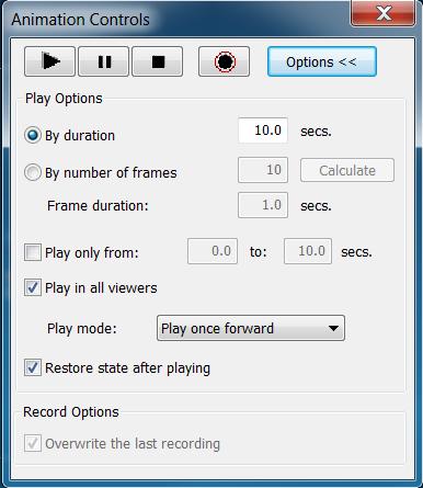
Bouncing ball animation made up of 6 frames
 Incorporating Animation into your Analysis and Presentation Colin Childs UC2009 Technical Workshop 1 Content What is Animation What is ArcGIS animation What can be Animated Animation concepts Building
ArcGIS for Developers: An Introduction. Moey Min Ken
 ArcGIS for Developers: An Introduction Moey Min Ken AGENDA Is development right for me? Building Apps on the ArcGIS platform Rest API & Web API Native SDKs Configurable Apps and Builders Extending the
CityEngine: An Introduction. Eric Wittner 3D Product Manager
 CityEngine: An Introduction Eric Wittner 3D Product Manager 2 minute city LegoScript + parameterized instructions + Legos Shapes = Scope and Geometry Shape Operations modify scope and geometry Rule = Sequence
Building Geoprocessing Tools with Python: Beyond the Basics. Dave Wynne
 Building Geoprocessing Tools with Python: Beyond the Basics Dave Wynne Building Geoprocessing Tools with Python: Getting Started Subhead Here This session will focus on creating polished, well-designed
ArcGIS Enterprise Extending Services. Bill Major
 ArcGIS Enterprise Extending Services Bill Major Agenda Introduction Geoprocessing tools Server Object Extensions Server Object Interceptors Demo APPS Desktop Web Device SHARING SERVICES Portal API DATA
Lidar and GIS: Applications and Examples. Dan Hedges Clayton Crawford
 Lidar and GIS: Applications and Examples Dan Hedges Clayton Crawford Outline Data structures, tools, and workflows Assessing lidar point coverage and sample density Creating raster DEMs and DSMs Data area
ArcGIS Enterprise: Architecture & Deployment. Anthony Myers
 ArcGIS Enterprise: Architecture & Deployment Anthony Myers 1 2 3 4 5 Web GIS Overview of ArcGIS Enterprise Federation & Hosted Server Deployment Patterns Implementation 1 Web GIS ArcGIS Enabling GIS for
ArcGIS Enterprise Building Raster Analytics Workflows. Mike Muller, Jie Zhang
 ArcGIS Enterprise Building Raster Analytics Workflows Mike Muller, Jie Zhang Introduction and Context Raster Analytics What is Raster Analytics? The ArcGIS way to create and execute spatial analysis models
Migrating from ArcMap to ArcGIS Pro. David Watkins Scott Noulis
 Migrating from ArcMap to ArcGIS Pro David Watkins Scott Noulis Getting Started with ArcGIS Pro ArcGIS Pro 64 bit, multi-threaded Simplified user interface Integrated with the ArcGIS platform Combined 2D/3D
ESRI Technology Update. Joe Holubar Larry Young
 ESRI Technology Update Joe Holubar Larry Young Continued Improvement Improving Quality and Extending and Refining Functionality First Half of 2009: Minor Update Release (ArcGIS 9.3.1) ArcGIS Explorer Fall
PYTHON: BUILDING GEOPROCESSING TOOLS. David Wynne, Geri Miller
 PYTHON: BUILDING GEOPROCESSING TOOLS David Wynne, Geri Miller Why we build geoprocessing tools Your work becomes part of the geoprocessing framework - Easy to access and run from within ArcGIS - Familiar
ArcGIS Pro: Image Segmentation, Classification, and Machine Learning. Jeff Liedtke and Han Hu
 ArcGIS Pro: Image Segmentation, Classification, and Machine Learning Jeff Liedtke and Han Hu Overview of Image Classification in ArcGIS Pro Overview of the classification workflow Classification tools
GeoPlanner Workshop. Esri Ocean GIS Forum November 4, Pete Aniello and Rob Stauder
 GeoPlanner Workshop Esri Ocean GIS Forum November 4, 2015 Pete Aniello and Rob Stauder Purpose and Take-aways Learn how to: - Create services - Use services in ArcGIS Online - Use services in GeoPlanner
ArcGIS Pro Editing: An Introduction. Jennifer Cadkin & Phil Sanchez
 ArcGIS Pro Editing: An Introduction Jennifer Cadkin & Phil Sanchez See Us Here WORKSHOP ArcGIS Pro Editing: An Introduction LOCATION SDCC - Ballroom 20 D TIME FRAME Thursday 10:00 11:00 ArcGIS Pro: 3D
ArcMap: Tips and Tricks
 Esri International User Conference San Diego, California Technical Workshops July 23 27, 2012 ArcMap: Tips and Tricks Miriam Schmidts Jorge Ruiz-Valdepena Agenda Navigating ArcMap Repairing data links
ArcGIS Runtime SDKs Building Offline Apps. Nick Furness
 ArcGIS Runtime SDKs Building Offline Apps Nick Furness Agenda The basics - Considerations - Building blocks - Service types New! Offline maps New! Preplanned workflow What we are covering and what not
FME / ArcGIS 9 Data Interoperability Extension
 FME / ArcGIS 9 Data Interoperability Extension About us Founded: 1993 Head office: Vancouver, Canada # of Employees: 45 Target markets: GIS & GPS vendors, Telecom and utilities, Oil & gas, Government agencies
ArcGIS Online: Best Practices for High-Demand Web Applications. Kelly Gerrow-Wilcox Bonnie Stayer Beth Romero
 ArcGIS Online: Best Practices for High-Demand Web Applications Kelly Gerrow-Wilcox Bonnie Stayer Beth Romero Agenda Communicating with Maps Who do you build your apps for? Layer Types Scalability and Response
What s New for Developers in ArcGIS Maura Daffern October 16
 What s New for Developers in ArcGIS 10.1 Maura Daffern October 16 mdaffern@esri.ca Today s Agenda This seminar is designed to help you understand: 1) Using Python to increase productivity 2) Overview of
Managing and Serving Elevation and Lidar Data. Cody Benkelman UC 2018
 Managing and Serving Elevation and Lidar Data Cody Benkelman UC 2018 Outline Usage Modes Data Management - Architecture - Workflow Automation for Repeatability & Scalability A few options Usage Modes of
Advanced Parcel Editing. Amy Andis Tim Hodson
 Advanced Parcel Editing Amy Andis Tim Hodson Overview What to expect in this technical workshop Review of the Parcel Fabric Data Model Advanced Tips and tricks for Parcel entry Assessing Quality of Parcel
What should y you expect in this session? Basic to advanced topics Outline What is map caching? Why should I cache? Caching workflow How to create a c
 Designing, Deploying, and Using Cached Map Services David Crosby & Craig Mesimer What should y you expect in this session? Basic to advanced topics Outline What is map caching? Why should I cache? Caching
Sharing Web Layers and Services in the ArcGIS Platform. Melanie Summers and Ty Fitzpatrick
 Sharing Web Layers and Services in the Platform Melanie Summers and Ty Fitzpatrick Agenda Platform overview - Web GIS information model - Two deployment options Pro Sharing - User experience and workflows
Desktop. ArcGIS Server. ArcGIS
 Getting Started with ArcGIS Server Nakul Bhatia and David Crosby ESRI Charlotte 1 Agenda g Overview of ArcGIS Server 9.3.1 Working with GIS Services Using g Web GIS Service Clients ArcGIS Online Map Caching
Image Services for Elevation Data
 Image Services for Elevation Data Peter Becker Need for Elevation Using Image Services for Elevation Data sources Creating Elevation Service Requirement: GIS and Imagery, Integrated and Accessible Field
LAB #7 Creating TIN and 3D scenes (ArcScene) GISC, UNIVERSITY OF CALIFORNIA BERKELEY
 GISC, UNIVERSITY OF CALIFORNIA BERKELEY") LAB #7 Creating TIN and 3D scenes (ArcScene) GISC, UNIVERSITY OF CALIFORNIA BERKELEY The purpose of this laboratory is to introduce and explore surface data analysis using a vector data model: TIN. We
LAB #7 Creating TIN and 3D scenes (ArcScene) GISC, UNIVERSITY OF CALIFORNIA BERKELEY The purpose of this laboratory is to introduce and explore surface data analysis using a vector data model: TIN. We
Introduction to GIS 2011
 Introduction to GIS 2011 Digital Elevation Models CREATING A TIN SURFACE FROM CONTOUR LINES 1. Start ArcCatalog from either Desktop or Start Menu. 2. In ArcCatalog, create a new folder dem under your c:\introgis_2011
Surface Creation & Analysis with 3D Analyst
 Esri International User Conference July 23 27 San Diego Convention Center Surface Creation & Analysis with 3D Analyst Khalid Duri Surface Basics Defining the surface Representation of any continuous measurement
Dynamic Situational Awareness. Through Developer Applications
 Dynamic Situational Awareness Through Developer Applications Mission Focused Applications Building Apps to support operations Agile Simple High-Performance Defense Developers GIS Simplifies Working With
Developing Add-Ins for ArcGIS Pro (.NET) Toronto Esri Canada UC Presented by: Gandhar Wazalwar & Kern Ranjitsingh October 11, 2018
 Toronto Esri Canada UC Presented by: Gandhar Wazalwar & Kern Ranjitsingh October 11, 2018") Developing Add-Ins for ArcGIS Pro (.NET) Toronto Esri Canada UC Presented by: Gandhar Wazalwar & Kern Ranjitsingh October 11, 2018 Esri Canada Professional Services Project services Implementation services
Developing Add-Ins for ArcGIS Pro (.NET) Toronto Esri Canada UC Presented by: Gandhar Wazalwar & Kern Ranjitsingh October 11, 2018 Esri Canada Professional Services Project services Implementation services
SkylineGlobe 6.5 s New Developments
 SkylineGlobe 6.5 s New Developments The SkylineGlobe Enterprise suite of applications was created to provide all of the necessary software tools for an organization to implement their own private, 3D virtual
START>PROGRAMS>ARCGIS>
 Department of Urban Studies and Planning Spring 2006 Department of Architecture Site and Urban Systems Planning 11.304J / 4.255J GIS EXERCISE 2 Objectives: To generate the following maps using ArcGIS Software:
Data Interoperability Advanced Use
 Data Interoperability Advanced Use Bruce Harold Dale Lutz bharold@esri.com Safe Software This is your world ask us today about best practices Automate Moving Data No Domain Limitations ArcGIS Data Interoperability
What's New in ArcGIS 9.2 Service Packs
 What's New in ArcGIS 9.2 Service Packs 8 July 2008 Updated for Service Pack 6 This document describes the main enhancements to 9.2 added by the service packs. It does not cover the bug fixes and quality
Understanding and using Metadata across the ArcGIS Platform. Aleta Vienneau Marten Hogeweg
 Understanding and using Metadata across the ArcGIS Platform Aleta Vienneau Marten Hogeweg Understanding and using Metadata across the ArcGIS Platform Metadata fundamentals ArcGIS platform Road ahead Metadata
introduction to 3D data
 introduction to 3D data MODELING WITH ARCGIS 3D ANALYST AND GOOGLE EARTH K. HEATHER KENNEDY Introduction to 3D Data Introduction to 3D Data Modeling with ArcGIS 3D Analyst and Google Earth K. Heather
ArcGIS Runtime SDK for WPF
 Esri Developer Summit in Europe November 9 th Rotterdam ArcGIS Runtime SDK for WPF Mike Branscomb Mark Baird Agenda Introduction SDK Building the Map Query Spatial Analysis Editing and Geometry Programming
Working with Elevation Data URPL 969 Applied GIS Workshop: Rethinking New Orleans After Hurricane Katrina Spring 2006
 Working with Elevation Data URPL 969 Applied GIS Workshop: Rethinking New Orleans After Hurricane Katrina Spring 2006 This GIS lab exercise will explore Light Detection And Ranging (LiDAR) data for New
Chris Rotondo, GIS Specialist. Prince George s County Planning Department The Maryland-National Capital Park and Planning Commission
 Chris Rotondo, GIS Specialist Prince George s County Planning Department The Maryland-National Capital Park and Planning Commission MSGIC, July 2015 A 150-page report on implementing 3D technology, prepared