City of Fontana. GIS: Making Life Easier Presenters: Joe Field, Rogelio Matta
|
|
|
- Maximilian Greer
- 5 years ago
- Views:
Transcription
1 City of Fontana GIS: Making Life Easier Presenters: Joe Field, Rogelio Matta
2 Fontana Fontana44.5 Square Miles Population 209, miles east of Los Angeles
3 Fontana Public Works Department 94 Staff $52 Million annual operating budget Streets Sewers Parks Streetscapes Fleet Buildings Environmental
4 Presentation Field Operations Section Technical Support Section
5 Field Operations Section It all starts with a work order
6 City of Fontana Context Using GIS to monitor: Plan Productivity Progress Performance


7 Operational Work Cycle Annual Planning Reporting Monitoring Annual Cycle Annual Work Plan Annual Budget
8 PWD GIS Reporting Evolution End user experience Paper map Digital map Task integrated, real-time map
9 The Gap Gap between the decision maker and the Field.
10 Management Director Analyst Manager Manager Manager
11 Field Supervisor Crew Chief Senior MSW II MSW I
12 Field Supervisor Crew Chief Senior MSW II MSW I
13 Management Director Analyst Manager Manager Manager
14 Information Bottleneck 58,549 Completed work orders annually Data Data Data Information
15 Simple Reporting Daily Report Monthly Report Quarterly Report Annual Report
16

17 Complex Reporting: Sewer CCTV KPI CCTV Planning Progress
18

19

20 June 2013

21 June 2015

22
23 Technical Support Section It all starts with a map
24 Problem You have Repeated process (Show in Map) That is slow Want to Show progress But you only want to do it Once! Tabular data Showing processed data

25 Tabular data

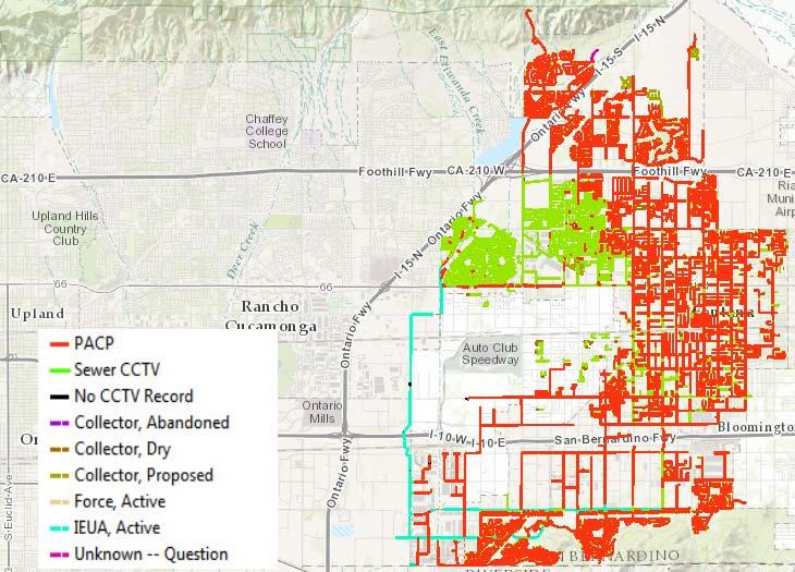
26 Tabular Data
27 What is geo-processing ESRI description What esri normally advertises Spatial analysis Projection Clip Travel Time Allows you to automate your GIS tasks. Can be run from ArcMAP My description Connects your data to your features It s a Script Relates and Joins But with ArcServer You have tool A MapService
28 Relationships One of the biggest tools esri has developed Is allowing you to relate to any database that you have access to. If you know how to join or relate tables you have the ability to see inside Lucity or any of your databases.
29 Types of Relationships Why is this important How Geoprocessing and Map Services work. One to One ( Live ) Asset One to Many ( Requires Execution ) Inspection records Work orders Views ( Live )

30 How to build Model Builder or Python Easiest Path is Model Builder
31 Once you have a Model Run the Model in the toolbox Publish the results to the server Create Map Service
32 What to do now! You have many options Publish to ArcGIS Online or Portal Add the layer to base map Make a map with a template or Web AppBuilder Or write your own Javascript Map

33 PACP Map What is being drawn Geoprocessing Mapservices
34 Data Mash up Two static Maps All Pipes were colored Black Pipes That Have CCTV records were colored green PACP pipes are drawn in red using a MapService Map was created in July of 2014 have not touched it since.


35 Water Consumption What is happening Map Services, 2013,2014,2015 JavaScript displaying the map data by rendering, popup and with a mouse-over
36 Advantage of JavaScript Languages, Libraries and Frameworks Customization DHTXML Sonic-Gauge Negative Gauge Esri examples Dojo HTML5 What it does Renders the points using the addbreak object To color the point Red -300 to -4 Blue -4 to 4 Green 4 to 300 Mouse-over to populate the display fields and move the needle.


37 Water Conservation What is happening Map service
38 Model Builder and JavaScript Model Builder Needed fields Have to calculate the values into the fields Have to select and clear select All temporary Leave only the fields you need What it does State Mandate % used Renders the points using the addvalue object To color the point by attribute Red Green Why different water district have different base reduction requirements

39
40 Lessons Learned PACP No Major Problems just working through the process of publishing Having to run a model from a tool Using the results window Sharing the Results Not Publishing with Map services checked Open Services Properties and check Map services after Publishing.


41 Trouble shooting Water Consumption Works in ArcMAP After Trouble shooting Can be trouble some Bad messages Had to take it to a staging services. Then publishing the staging services got a error message Joined data to Feature services

42 Trouble shooting One to Many Entered in 2015 Found a bug Have to write data out to memory
43 Documents Contact Me:
44 Questions
TRAINING GUIDE. GIS Session Preview (New Features) 2017 and 2017r2
 2017 and 2017r2") TRAINING GUIDE GIS Session Preview (New Features) 2017 and 2017r2 GIS Session Preview (New Features) 2017 and 2017r2 In this session, we ll provide an overview of GIS changes since ACT 2016 and a sneak
TRAINING GUIDE GIS Session Preview (New Features) 2017 and 2017r2 GIS Session Preview (New Features) 2017 and 2017r2 In this session, we ll provide an overview of GIS changes since ACT 2016 and a sneak
Traverse City Asset Management Plan
 Utilities and Public Services Larry LaCross, GISP, Asset Management/GIS Analyst Traverse City Department of Public Services Introduction About Traverse City (TC) TC Assets Department of Public Services
Texas Legislative Council
 Texas Legislative Council Clare Dyer, Manager, Mapping & Redistricting Ed Clow, GISP, Programmer Analyst, Applications Marshall Kunze, Programmer, Applications Texas Redistricting 2011 Time frame for Texas
Esri Best Practices: QA/QC For Your Geodata. Michelle Johnson & Chandan Banerjee
 Esri Best Practices: QA/QC For Your Geodata Michelle Johnson & Chandan Banerjee Overview Understand Document Implement Understanding QA/QC Understanding QA/QC Fit For Use - support your GIS applications?
CITY OF LATHROP SALARY SCHEDULE Effective 7/1/2018
 POSITION TITLE STEP 1 STEP 2 STEP 3 STEP 4 STEP 5 Accountant Hourly 29.44 30.91 32.46 34.08 35.79 Bi-Weekly 2,355.34 2,473.11 2,596.77 2,726.61 2,862.94 Monthly 4,710.69 4,946.22 5,193.53 5,453.21 5,725.87
hereby recognizes that Timotej Verbovsek has successfully completed the web course 3D Analysis of Surfaces and Features Using ArcGIS 10
 3D Analysis of Surfaces and Features Using ArcGIS 10 Completed on September 5, 2012 3D Visualization Techniques Using ArcGIS 10 Completed on November 19, 2011 Basics of Map Projections (for ArcGIS 10)
Lesson 8 : How to Create a Distance from a Water Layer
 Created By: Lane Carter Advisor: Paul Evangelista Date: July 2011 Software: ArcGIS 10 Lesson 8 : How to Create a Distance from a Water Layer Background This tutorial will cover the basic processes involved
TRAINING GUIDE. ArcGIS Online and Lucity
 TRAINING GUIDE ArcGIS Online and Lucity ArcGIS Online and Lucity This covers some basic functionality we feel you will need to be successful with Lucity with ArcGIS Online or Portal for ArcGIS Enterprise.
Make Your GIS Work for You, First Step: Data Quality
 Make Your GIS Work for You, First Step: Data Quality Presented by: Scott Sumners, GIS Manager, City of Brentwood James McCord, GIS Analyst, City of Brentwood Gerardo Boquin, GISP /CH2M Brentwood GIS CAD
City of Denton s Proactive Approach to Asset Management featuring InfoMaster & Cityworks
 City of Denton s Proactive Approach to Asset Management featuring InfoMaster & Cityworks Presentation Scope Why asset management Software tools used in Denton asset management plan Detail discussion of
TRAINING GUIDE. GIS Editing Tools for ArcGIS Desktop
 TRAINING GUIDE GIS Editing Tools for ArcGIS Desktop Editing Tools for ArcGIS Desktop Lucity GIS contains an editor extension that tracks edits made to the Lucity GIS geodatabase and ensures that those
KENYA 2019 Training Schedule
 KENYA 2019 Training Schedule Monday Tuesday Wednesday Thursday Friday 4th Feb 5th Feb 6th Feb 7th Feb 8th Feb Using 11th Feb 12th Feb 13th Feb 14th Feb 15th Feb Using (cont...) Field Data Collection and
TRAINING GUIDE. Lucity Webmap 2017r2
 TRAINING GUIDE Lucity Webmap 2017r2 Web Map The Lucity Web Map provides a way for users to see and work with their asset and work data. This allows them to see relationships between objects and plan work
Agile Traffic Reporting During Construction: A Public Relations Solution Integrating GIS and Waze
 Agile Traffic Reporting During Construction: A Public Relations Solution Integrating GIS and Waze Berkley Myers, GISP Eastern Region GIS Team Lead Hanover, MD Overview Cambridge, MA Alewife Project and
Setting Up Your Working Environment
 Setting Up Your Working Environment What are the topics? - Setting Up Your Working Environment - What is a feature class? ArcGIS Program Modules ArcScene ArcGIS ArcGlobe ArcCatalog ArcMap ArcToolbox Program
Pre-Incident Planning ( PIP )
") Pre-Incident Planning ( PIP ) Presentation Overview 1) Web GIS Terminology Review 2) Technical Details of PIP 3) The Start of PIP 4) PIP & General Maintenance Currently 1 year old Dashboards & Python 5)
Pre-Incident Planning ( PIP ) Presentation Overview 1) Web GIS Terminology Review 2) Technical Details of PIP 3) The Start of PIP 4) PIP & General Maintenance Currently 1 year old Dashboards & Python 5)
Explore some of the new functionality in ArcMap 10
 Explore some of the new functionality in ArcMap 10 Scenario In this exercise, imagine you are a GIS analyst working for Old Dominion University. Construction will begin shortly on renovation of the new
Creating and editing attributes
 Creating and editing attributes Miriam Schmidts Lesson 2 Learning objectives Perform efficient attribute edits using - Attributes window - Field Calculator - Calculate Geometry - Attribute Transfer Choose
Connecting Space and Time OSIsoft & Esri
 Connecting Space and Time OSIsoft & Esri Presented by Michelle Kuiee Product Manager Frank Batke Senior Systems Engineer 2 Which of these describe your need? Operating Engineers & Analysts Environmental
Lab 1: Exploring ArcMap and ArcCatalog In this lab, you will explore the ArcGIS applications ArcCatalog and ArcMap. You will learn how to use
 Lab 1: Exploring ArcMap and ArcCatalog In this lab, you will explore the ArcGIS applications ArcCatalog and ArcMap. You will learn how to use ArcCatalog to find maps and data and how to display maps in
City of San Antonio Utilizing Advanced Technologies for Stormwater System Mapping and Condition Assessments
 City of San Antonio Utilizing Advanced Technologies for Stormwater System Mapping and Condition Assessments Prepared for: Prepared by Noelle Gaspard, PE, GISP, CFM Agenda Purpose Project Overview Challenges
Creating our Public Works Story
 Creating our Public Works Story The Evolution of an Interactive Map Application for Rancho Cordova Public Works April 26 th, 2017 Brad Findlay, GIS Analyst Interwest Consulting Group Overview Introduction
Urban vs Rural Selection Tool
 Urban vs Rural Selection Tool This tool was developed to aid in determination of whether a project/facility location is considered to be urban or rural per EPA s guidance. The tool allows the identification
City of San Antonio Utilizing Advanced Technologies for Stormwater System Mapping and Condition Assessments
 City of San Antonio Utilizing Advanced Technologies for Stormwater System Mapping and Condition Assessments Prepared for: 2017 ESRI Users Conference Prepared by Noelle Gaspard, PE, GISP, CFM July 12,2017
Citizen Reporter App for DuPage County. Illinois GIS Association Annual Conference Ryan Nosek, GIS Analyst, DuPage County October 18 th, 2016
 Citizen Reporter App for DuPage County Illinois GIS Association Annual Conference Ryan Nosek, GIS Analyst, DuPage County October 18 th, 2016 Presentation Topics Crowdsourcing Apps from Esri Crowdsource
METROPOLITAN SEWERAGE DISTRICT of Buncombe County, N.C. PIPE RATING PROGRAM. Aqua Salubris
 METROPOLITAN SEWERAGE DISTRICT of Buncombe County, N.C. PIPE RATING PROGRAM Aqua Salubris Pipe Rating Program What is it? A new, proactive program used to define and develop rehabilitation projects. The
PI Integrator for Esri ArcGIS: A Journey Through Time and Space
 PI Integrator for Esri ArcGIS: A Journey Through Time and Space Presented by Vadim Fedorov, Sr. Systems Engineer Elizabeth Ammarell, Product Manager The Past: Where We Started 2 Two companies, one vision
Priming the Pump Stage II
 Priming the Pump Stage II Modeling and mapping concentration with fire response networks By Mike Price, Entrada/San Juan, Inc. The article Priming the Pump Preparing data for concentration modeling with
Configuring the ArcGIS for Local Government Solution
 Configuring the ArcGIS for Local Government Solution Lindsay Thomas Steve Grise Scott Oppmann Esri UC 2015 Technical Workshop Agenda Introduction Configuration Patterns Implementation Approaches Your Feedback
Does Your Data Have Harmony. Dan Stone
 Does Your Data Have Harmony Dan Stone Agenda Introduction Configuration Patterns Implementation Approaches Your Feedback ArcGIS for Local Government Esri solutions for local government customers Series
8 Querying and Selecting Data
 8 Querying and Selecting Data In this chapter, we will cover the following recipes: ff ff ff ff ff Constructing proper attribute query syntax Creating feature layers and table views Selecting features
No Programming Required Create web apps rapidly with Web AppBuilder for ArcGIS
 No Programming Required Create web apps rapidly with Web AppBuilder for ArcGIS By Derek Law, Esri Product Manager, ArcGIS for Server Do you want to build web mapping applications you can run on desktop,
ArcMap: Tips and Tricks
 Esri International User Conference San Diego, California Technical Workshops July 23 27, 2012 ArcMap: Tips and Tricks Miriam Schmidts Jorge Ruiz-Valdepena Agenda Navigating ArcMap Repairing data links
Integration of Business Continuity, Emergency Preparedness, and Emergency Response
 Integration of Business Continuity, Emergency Preparedness, and Emergency Response Continuity Insights Conference 2014 Julia Halsne Manager of Business Continuity East Bay Municipal Utility District Contents
ArcGIS Desktop: Introduction to Geoprocessing with ModelBuilder Kevin Armstrong ESRI
 ArcGIS Desktop: Introduction to Geoprocessing with ModelBuilder Kevin Armstrong ESRI SERUG 2008 1 What is ModelBuilder? A user-friendly way to automate a series of tools Part of the ArcGIS geoprocessing
TRAINING GUIDE. Mobile for Administrators Part 3 - GIS
 TRAINING GUIDE Mobile for Administrators Part 3 - GIS Mobile for Administrators - GIS One of the critical components of mobile is GIS, and it can also be the most complex. The mobile GIS maps are designed
Modernizing California State Highway Right of Way Records with GIS. Caltrans District 4 Oakland, CA
 Modernizing California State Highway Right of Way Records with GIS Caltrans District 4 Oakland, CA About Us Kirsten Lawrence (GISP), Senior Geospatial Analyst on staff augmentation contract with Caltrans
TRAINING GUIDE. Tablet: Cradle to Mobile GIS
 TRAINING GUIDE Tablet: Cradle to Mobile GIS Tablet Cradle to Mobile One of the critical components of mobile is the GIS piece, and also can be the most complex. The mobile GIS maps are designed to consume
USING WEB APPBUILDER TO TRACK TEMPORARY WATER METER DEPLOYMENTS. Olivia DeSimone, GISP GIS Analyst City of Altamonte Springs
 USING WEB APPBUILDER TO TRACK TEMPORARY WATER METER DEPLOYMENTS Olivia DeSimone, GISP GIS Analyst City of Altamonte Springs CITY OF ALTAMONTE SPRINGS Located in Seminole County (Central Florida) Seminole
Working with Feature Layers. Russell Brennan Gary MacDougall
 Working with Feature Layers Russell Brennan Gary MacDougall Working with Feature Layers Session will focus on feature access and editing Highlight new features added over the last few releases Agenda Introduction
Advances in GIS help create Smarter Communities
 Advances in GIS help create Smarter Communities POP(ovich) Quiz Who is a Desktop User? Who is an ArcGIS Online User? Who is a ArcGIS Server Admin? Who is a Programmer? Who works with or for a government
Select the Parks within Forest Acres
 Select the Parks within Forest Acres TASKS RESULT 1. Add the county boundary, municipalities and parks (pts.) layers to your map 2. Save your map (.mxd) to your desktop Your map should look something like
SAWS SSO Program Achievements
 SAWS SSO Program Achievements Jeff Haby, P.E. Vice President Production & Treatment September 21, 2018 September 21, 2018 Page 2 Path Forward Overview SAWS by the Numbers Consent Decree Key Elements Innovation
Web App Builder: Code-free Development. Adam Ziegler, Esri-Northeast, Local Government Team
 Web App Builder: Code-free Development Adam Ziegler, aziegler@esri.com Esri-Northeast, Local Government Team Agenda Product overview Web AppBuilder for ArcGIS tour Adding Custom Widgets Community and Resources
Web AppBuilder for ArcGIS: JavaScript Apps Made Easy
 Web AppBuilder for ArcGIS: JavaScript Apps Made Easy Ryan Sellman @rcsellman Agenda Product overview Web AppBuilder for ArcGIS tour Customization Community and Resources Summary The ArcGIS Platform enables
Ray Garrett Senior Manager Utilities Records Integration (URI) Department With UM since FTEs in URI, 2 shared support UNIVERSITY OF MICHIGAN
 Department With UM since FTEs in URI, 2 shared support UNIVERSITY OF MICHIGAN") University of Michigan Founded: 1817 Ann Arbor Campus Number of Buildings: ~750 Campus Size: ~3200 acres Gross Sq Ft: ~40M Ray Garrett Senior Manager Utilities Records Integration (URI) Department With
University of Michigan Founded: 1817 Ann Arbor Campus Number of Buildings: ~750 Campus Size: ~3200 acres Gross Sq Ft: ~40M Ray Garrett Senior Manager Utilities Records Integration (URI) Department With
Working with tables. Using Quantum GIS
 Using Quantum GIS Tutorial ID: IGET_GIS_008 This tutorial has been developed by BVIEER as part of the IGET web portal intended to provide easy access to geospatial education. This tutorial is released
A Regional Water Utility and the Private Sector Defining a Partnership for Infrastructure Delivery
 A Regional Water Utility and the Private Sector Defining a Partnership for Infrastructure Delivery Carmel Krogh Director Shoalhaven Water Shoalhaven City Council Shoalhaven City Council Structure Asset
KEEPING DATA ACCURATE WITH THE DUSA APPLICATION
 KEEPING DATA ACCURATE WITH THE DUSA APPLICATION Jenn Sylvester, Mapping Branch Team Lead Adam Breznicky, Mapping Branch Web Master Transportation Planning & Programming Division (TPP) ESRI International
ROI CASE STUDY IBM SPSS CITY OF LANCASTER. ROI: 1301% Payback: 1.5 months Average annual benefit: $1,344,338. Cost : Benefit Ratio 1 : 45.
 ROI CASE STUDY IBM SPSS CITY OF LANCASTER THE BOTTOM LINE The City of Lancaster, California needed to gain greater visibility into where Part I crimes were occurring and where they were expected to occur
Utility Network Management in ArcGIS: Migrating Your Data to the Utility Network. John Alsup & John Long
 Utility Network Management in ArcGIS: Migrating Your Data to the Utility Network John Alsup & John Long Presentation Outline Utility Network Preparation - Migration Patterns - Understanding the Asset Package
USING GIS TO TRANSFORM YOUR ORGANIZATION. Reengineering a GIS Department. TRA Adopts a Business Solution Approach ESRI UC 2017
 USING GIS TO TRANSFORM YOUR ORGANIZATION Reengineering a GIS Department TRA Adopts a Business Solution Approach ESRI UC 2017 Glenn Clingenpeel, Bob Ayensu Outline 1. History of TRA 2. Overview 3. Approach
City of Aliso Viejo Salary Schedule Effective: January 1, 2019
 Effective: January, 0 Accountant, 0,,0 Accountant/Payroll,, 0,, 0, 0,,,,0 Assistant Planner,,,0 Associate Engineer,0,0 0, Associate Planner,,, 0,0,,0,,,0 (PT)..0. Community Services Manager, 0,,,,, Community
Runestone Electric Association s (REA) AMI Implementation Using Collector for ArcGIS
 AMI Implementation Using Collector for ArcGIS") Runestone Electric Association s (REA) AMI Implementation Using Collector for ArcGIS Scott Krueger, Billing/IT Supervisor For Runestone Electric Association Hillary Bjorstrom, GIS Analyst For STAR Energy
Runestone Electric Association s (REA) AMI Implementation Using Collector for ArcGIS Scott Krueger, Billing/IT Supervisor For Runestone Electric Association Hillary Bjorstrom, GIS Analyst For STAR Energy
ArcGIS Network Analyst and Network Dataset. Jim McKinney ESRI
 ArcGIS Network Analyst and Network Dataset Jim McKinney ESRI ArcGIS Network Analyst Everything in ArcView GIS 3x and more Routing Directions Network Analysis Tight Integration with Geoprocessing Models
Best Practices for Creating Web Maps. Brian Chong Justin Fan
 Best Practices for Creating Web Maps Brian Chong Justin Fan Agenda Overview of web maps Designing maps for the web Develop effective web maps What is a Web Map? Contains one or more GIS services Integrated
ArcGIS for Developers: An Introduction. Moey Min Ken
 ArcGIS for Developers: An Introduction Moey Min Ken AGENDA Is development right for me? Building Apps on the ArcGIS platform Rest API & Web API Native SDKs Configurable Apps and Builders Extending the
Web AppBuilder Presented by
 Web AppBuilder Presented by Agenda Product overview Web AppBuilder for ArcGIS tour What s new in the ArcGIS Online June 2016 update Customization Community and Resources Summary The ArcGIS Platform enables
What s New in ArcGIS 10.3 for Server. Tom Shippee Esri Training Services
 What s New in ArcGIS 10.3 for Server Tom Shippee Esri Training Services Today s Agenda What is ArcGIS for Server at 10.3 - ArcGIS Platform story - Expanding ArcGIS for Server paradigm What s new in ArcGIS
City of Mobile GIS Web Mapping Applications: New Technology, New Expectations
 City of Mobile GIS Web Mapping Applications: New Technology, New Expectations Presenters : Scott Kearney GIS Manager Patricia Creamer GIS Analyst Background: GIS Department Developing web mapping apps
Dakota County, Minnesota
 APWA Public Works Expo August 2016 Kevin L. Schlangen, CPFP, CAFM, CEM Fleet Manager, Dakota County, Minnesota Dakota County, Minnesota 2013 population 408,509 3 rd largest MN County of 87 587 square miles
BALTIMORE UTILITY ASSET MANAGEMENT DIVISION
 BALTIMORE UTILITY ASSET MANAGEMENT DIVISION Baltimore City s Asset Management Program Sustainable Best Management Practices in Transportation Workshop July 16, 2013 Rudy S. Chow, P.E. Bureau Head Alfred
Notes: Notes: Notes: Notes:
 NR406 GIS Applications in Fire Ecology & Management Lesson 2 - Overlay Analysis in GIS Gathering Information from Multiple Data Layers One of the many strengths of a GIS is that you can stack several data
PUBLIC WORKS ORGANIZATIONAL CHART
 PUBLIC WORKS ORGANIZATIONAL CHART C-108 Actual 2012-13 Adopted Year-End Estimated 2014-15 2015-16 PROGRAM EXPENSES/REVENUES Salaries & Benefits $ 1,725,030 $ 1,855,980 $ 1,676,130 $ 1,956,510 $ 1,979,470
Starting the QGIS Program. Exercise 1: Exploring QGIS
 Exercise 1: Exploring QGIS In this exercise you will learn how to open maps, manipulate layers, add spatial data, change symbols, and navigate within QGIS. You will also learn to repair broken data links.
ESRI Mobile GIS Solutions Overview. Justin Fan
 ESRI Mobile GIS Solutions Overview Justin Fan Agenda Mobile GIS challenges ESRI Mobile GIS solutions ArcPad ArcGIS Mobile ArcGIS Engine Selecting a mobile GIS solution Q & A Objective To help you select
Geo Apps: Modern Day GIS
 Geo Apps: Modern Day GIS Exercise 1: Create a customer service request app Estimated time: 20 minutes Exercise 2: Create a story map Estimated time: 30 minutes Exercise 3: Use Web AppBuilder for ArcGIS
Troubleshooting Performance Issues with Enterprise Geodatabases. Ben Lin, Nana Dei, Jim McAbee
 Troubleshooting Performance Issues with Enterprise Geodatabases Ben Lin, Nana Dei, Jim McAbee blin@esri.com ndei@esri.com jmcabee@esri.com Workshop Agenda Performance Troubleshooting (Then & Now) Real-World
2016 New Zealand Spatial Excellence Awards: Category: Award for Technical Excellence - Award Application
 Lessons learned from one of New Zealand s most challenging civil engineering projects: rebuilding the earthquake damaged pipes, roads, bridges and retaining walls in the city of Christchurch 2011-2016.
Understanding ArcGIS Pipeline Referencing for Vertically Integrated Gas Companies. GeoConX 2017 September 7, 2017
 Understanding ArcGIS Pipeline Referencing for Vertically Integrated Gas Companies GeoConX 2017 September 7, 2017 The Asset Intelligence Imperative GOAL The necessity to learn ever more, in as close to
Creating Geoprocessing Services and Web Tools. Darren Baird, PE, Esri
 Creating Geoprocessing Services and Web Tools Darren Baird, PE, Esri Introduction Both ArcMap and ArcGIS Pro are covered Terms Geoprocessing Services and Web Tools are the same - ArcMap publishes geoprocessing
Sharing GIS Content Using ArcGIS STUDENT EDITION
 Sharing GIS Content Using ArcGIS STUDENT EDITION Copyright 2018 Esri All rights reserved. Course version 1.1. Version release date April 2018. Printed in the United States of America. The information contained
Section 1: Introduction to Arc GIS 10
 Introduction to ArcGIS 10 Getting Started 1.1.1 Section 1: Introduction to Arc GIS 10 A main component of ArcGIS 10 software is ArcMap. It can be used to create and edit maps and analyze spatial data.
TRAINING GUIDE. Tablet Cradle to Mobile GIS
 TRAINING GUIDE Tablet Cradle to Mobile GIS Tablet Cradle to Mobile One of the critical components of mobile is the GIS piece, and also can be the most complex. The mobile GIS maps are designed to consume
GeoPlanner Workshop. Esri Ocean GIS Forum November 4, Pete Aniello and Rob Stauder
 GeoPlanner Workshop Esri Ocean GIS Forum November 4, 2015 Pete Aniello and Rob Stauder Purpose and Take-aways Learn how to: - Create services - Use services in ArcGIS Online - Use services in GeoPlanner
Proposed Increase In Rates In Water, Sewer and Reclaimed. June 9, 2009
 Proposed Increase In Rates In Water, Sewer and Reclaimed June 9, 2009 1 WATER 2 3 Reclaimed Water Accounts 27,500 25,000 22,500 20,000 17,500 15,000 12,500 10,000 7,500 5,000 2,500 387-24,863 4 FY 96 FY
ArcGIS Desktop The Road Ahead. Amadea Azerki
 ArcGIS Desktop The Road Ahead Amadea Azerki Agenda An Overview of ArcGIS 10 Desktop Enhancements User Interface Mapping Editing Analysis Sharing Q & A ArcGIS 10 Overview Focuses on Usability and Productivity
ModelBuilder: An Introduction. Kevin Armstrong
 ModelBuilder: An Introduction Kevin Armstrong What is ModelBuilder? A user-friendly way to automate a series of tools Part of the ArcGIS geoprocessing framework - ModelBuilder can run any tool in the ArcToolbox,
Module 10 Data-action models
 Introduction Geo-Information Science Practical Manual Module 10 Data-action models 10. INTRODUCTION 10-1 DESIGNING A DATA-ACTION MODEL 10-2 REPETITION EXERCISES 10-6 10. Introduction Until now you have
Welcome to NR402 GIS Applications in Natural Resources. This course consists of 9 lessons, including Power point presentations, demonstrations,
 Welcome to NR402 GIS Applications in Natural Resources. This course consists of 9 lessons, including Power point presentations, demonstrations, readings, and hands on GIS lab exercises. Following the last
System Design and Tuning
 System Design and Tuning Lucity 2018 R2 Overview Lucity Specifications 2018 R2 Web Identity Server Document Server File Server Database Server Service Server Citizen Portal Mobile Server Android Devices
ArcGIS Pro: Effective License Management. Stephanie Wendel Melanie Summers Rob Elkins
 ArcGIS Pro: Effective License Management Stephanie Wendel Melanie Summers Rob Elkins Effective License Management Licensing Model Key Concepts Setting Up and Managing your Organization Grouping Users How
Overview of Server Technologies. Katja Krivoruchko ESRI
 Overview of Server Technologies Katja Krivoruchko ESRI Agenda Introduction to Server Technology Workflow Considerations ESRI Server Technology ArcSDE ArcGIS Server ArcGIS Image Server File Server Implementation
LUCITY SECURITY. This manual covers managing users, groups, and permissions for Lucity. Version: 2017r2
 LUCITY SECURITY This manual covers managing users, groups, and permissions for Lucity. Version: 2017r2 CONTENTS SECURITY... 1 Security Program... 2 Getting Started... 3 Setting up a Security Admin User...
Network Analysis with ArcGIS Online and On-premise Services
 2013 Esri International User Conference July 8 12, 2013 San Diego, California Technical Workshop Network Analysis with ArcGIS Online and On-premise Services Deelesh Mandloi Dmitry Kudinov Esri UC2013.
INSTRUCTIONS FOR THE 2017 ONLINE MCES SEWER SURVEY
 METROPOLITAN COUNCIL ENVIRONMENTAL SERVICES (MCES) 390 North Robert Street St. Paul, Minnesota 55101 INSTRUCTIONS FOR THE 2017 ONLINE MCES SEWER SURVEY I. BACKGROUND INFORMATION GENERAL INFORMATION A.
Washington Statewide Trails Database Project
 Washington Statewide Trails Database Project Project Overview Washington still is missing a statewide trails database. To date, some of the state and federal hiking, biking, horse and rail trails data
Working with Printing Service: Advanced Topics JEFF MOULDS TANU HOQUE
 Working with Printing Service: Advanced Topics JEFF MOULDS TANU HOQUE Session outline Subhead Here What is printing service and how it works? Use secured services with printing service ArcPy based printing
Director of Public Works/City Engineer. Secretary. Word Processor. Streets and Facilities Supervisor. Traffic Signal Technician.
 PUBLIC WORKS ORGANIZATIONAL CHART Director of Public Works/City Engineer Secretary Word Processor Transit Services Manager Fleet Services Supervisor Streets and Facilities Supervisor Principal Principal
5 Servicing Capacity Assignment for Aurora, East Gwillimbury and Newmarket
 Clause 5 in Report No. 11 of Committee of the Whole was adopted, without amendment, by the Council of The Regional Municipality of York at its meeting held on June 28, 2018. 5 Servicing Capacity Assignment
ArcMap Tips and Tricks
 2013 Esri International User Conference July 8 12, 2013 San Diego, California Technical Workshop ArcMap Tips and Tricks Jack Horton Jorge Ruiz-Valdepeña Esri UC2013. Technical Workshop. Jorge s Agenda
Chris Rotondo, GIS Specialist. Prince George s County Planning Department The Maryland-National Capital Park and Planning Commission
 Chris Rotondo, GIS Specialist Prince George s County Planning Department The Maryland-National Capital Park and Planning Commission MSGIC, July 2015 A 150-page report on implementing 3D technology, prepared
ArcGIS for Server: Publishing and Using Map Services
 ArcGIS for Server: Publishing and Using Map Services Matthias Schenker Gerhard Trichtl m.schenker@esri.ch g.trichtl@mysynergis.com Agenda Platform overview Publishing services - Demo: Publishing hosted
Linus L. Smith, GIS Supervisor, Engineering Public Works Department, City of Winfield, Kansas
 Challenges in Developing a City GIS Wastewater Geo Database System Linus L. Smith, GIS Supervisor, Engineering Public Works Department, City of Winfield, Kansas OVERVIEW The City of Winfield Kansas recognized
TRANSITIONING TO A WEB- BASED DATA MANAGEMENT AND DATA SHARING MODEL. Chris Bardash, GISP
 TRANSITIONING TO A WEB- BASED DATA MANAGEMENT AND DATA SHARING MODEL Chris Bardash, GISP The Problem No single source for GIS data at TxDOT Repeat requests for data are time consuming Very little data
GEOG 677 FINAL PROJECT: PRACTICAL USES OF ONLINE MAPPING APPLICATIONS
 GEOG 677 FINAL PROJECT: PRACTICAL USES OF ONLINE MAPPING APPLICATIONS ArcGIS App Builder vs. ArcGIS JS API vs. Google Maps API Cynthia Hartley 2/22/2015 University of Maryland: MPS in GIS GEOG 677: Internet
Building Applications with the ArcGIS Runtime SDK for WPF
 Esri International User Conference San Diego, California Technical Workshops 24 th July 2012 Building Applications with the ArcGIS Runtime SDK for WPF Euan Cameron & Paul Pilkington Agenda Introduction
TRAINING GUIDE. GIS Admin for Web and Mobile Maps
 TRAINING GUIDE GIS Admin for Web and Mobile Maps GIS Admin for Web and Mobile Maps In this session, we ll cover the tools necessary to properly configure Lucity to work with your GIS environment. We ll
Esri Production Mapping: Configuring the Solution for Civilian Topographic Agencies. Sean Granata
 Esri Production Mapping: Configuring the Solution for Civilian Topographic Agencies Sean Granata What s New Version 4.0 (Released) - Distributed Generalization Version 5.0 - Support for 10K Map Products
Georeferencing and Digitizing
 INTRODUCTION There is a great deal of geographic data available in formats that cannot be immediately integrated with other GIS data. In order to use these types of data in GIS it is necessary to align