Southeast Florida FSUTMS Users Group Cube 5.0 Hands-On Training Workshop
|
|
|
- Silas Bates
- 5 years ago
- Views:
Transcription

1 Southeast Florida FSUTMS Users Group Cube 5.0 Hands-On Training Workshop Sponsored by FDOT Central Systems Planning Office, FDOT-D4, & Citilabs Date: Tuesday, July 1, 2008 Time: 10:00 AM Location: FDOT-D4 Ft. Lauderdale Operations Center 5548 N.W. 9th Ave (Powerline Rd.), Ft. Lauderdale, FL AGENDA 10:00 ~ 10:15 Welcome, Introduction, & Announcements Min-Tang Li, FDOT-D4 10:15 ~ 12:00 Cube 5.0 Training Section I Wade White, Citilabs 12:00 ~ 13:30 Lunch Break (on your own) 13:30 ~ 15:30 Cube 5.0 Training Section II Wade White, Citilabs 15:30 ~ 15:45 Break 15:45 ~ 16:30 Questions and Discussions 16:30 Adjournment Next Meeting: 9:30 AM, Friday, August 15, 2008.

2 Using Embedded ArcGIS Features In Cube 5 Cube 5 Hands-On Workshop July 1, 2008 Wade White, AICP 1 About Cube 5.0 A Review New Cube Graphics Window for mapping GIS data ESRI ArcGIS Engine same display technology used by ArcGIS Desktop Cube Geodatabases same data storage format used by ArcGIS Desktop Existing models can run using Cube Geodatabase inputs & outputs New models can be built from GIS data in standard ESRI formats Maps featuring model data can be shared with GIS staff Many familiar user interface elements and tools 2 SE FL Model User Group, 7/1/08 1
")
 Automation (VBA etc ) Extensions Applications ESRI ArcGIS o o o Microsoft Office Access Excel VBA SQL Server Visual Studio Microsoft Software &")

3 ArcGIS and Cube Compared The ArcGIS Flower The Cube Flower product ArcGIS placearcgis target market ArcGISprice ArcGIS promotion 3 Related Technologies o o o o ArcGIS Desktop ArcView ArcEditor ArcMap, ArcCatalog, ArcToolbox ArcInfo ArcPublisher/ArcReader Server GIS (replaces ArcSDE) ArcGIS Server ArcGIS Image Server ArcIMS (web delivery) Geodatabase types Enterprise Workgroup Personal File Developer Tools Scripting (Python etc ) Automation (VBA etc ) Extensions Applications ESRI ArcGIS o o o Microsoft Office Access Excel VBA SQL Server Visual Studio Microsoft Software & Standards SDE GDB SHP MDB ArcGIS Engine Citilabs Cube o o o o o o o o Cube Base Cube Graphics Application Manager Scenario Manager Cube Voyager Cube Cluster Cube Avenue Cube Land Cube Analyst Cube Cargo Cube Dynasim Accession Polar Cube Web o TP+ o TRANPLAN o TRIPS 4 SE FL Model User Group, 7/1/08 2


4 Importing & Managing Data Creating & Opening Geodatabases Importing Feature Classes From Legacy Formats Point, Line, and Polygon Shapefiles Cube Voyager Highway & Transit Networks Copy Feature Class To & From Other GDBs Building Networks From Feature Classes Setting Spatial Reference & Projection Export to Legacy Formats Model Considerations 5 Getting Started Creating a Cube Geodatabase 6 SE FL Model User Group, 7/1/08 3
 Text PT Line Files (*.lin) Text NT Leg Files (*.")
 7 Importing a Citilabs Network Yes Auto-detect spatial reference True")
5 Importing Feature Classes From Legacy Formats Supported formats: Citilabs Network Files (*.net) Text PT Line Files (*.lin) Text NT Leg Files (*.ntl) ESRI Shape Files (*.shp) xbase DBF Files (*.dbf) 7 Importing a Citilabs Network Yes Auto-detect spatial reference True Shape PRJ? No 8 SE FL Model User Group, 7/1/08 4


6 Automatic Import Checks SQL reserved words Network distance scale 9 Importing Transit Lines Select the highway h network to which h the transit data correspond You can change this setting later using the Synchronize button (available only when transit data are highlighted in the geodatabase browse. 10 SE FL Model User Group, 7/1/08 5

7 Importing a Shapefile Yes Auto-detect spatial reference *.PRJ file exist? No 11 Getting & Setting Spatial Reference Information Yes Info Eit Exists? No 12 SE FL Model User Group, 7/1/08 6


8 Building a Network Input: MDB or SHP Output: MDB or NET 13 Copying Data Between GDB Files Open source GDB Select source data Select destination GDB 14 SE FL Model User Group, 7/1/08 7
 15 The Geodatabase in Voyager The following modules can now read and write data (primarily attribute tables) to and from geodatabases: MATRIX, GENERATION, FRATAR, DISTRIBUTION NETWORK HIGHWAY")
9 Exporting Data to Legacy Formats Supported formats: Citilabs Network Files (*.net) Text PT Line Files (*.lin) Text NT Leg Files (*.ntl) ESRI Shape Files (*.shp) xbase DBF Files (*.dbf) 15 The Geodatabase in Voyager The following modules can now read and write data (primarily attribute tables) to and from geodatabases: MATRIX, GENERATION, FRATAR, DISTRIBUTION NETWORK HIGHWAY PUBLIC TRANSPORT Legacy binary network files can still be used for intermediate model steps if desired. 16 SE FL Model User Group, 7/1/08 8


10 Referencing Geodatabases In general geodatabase feature classes can be referenced in script using the full path: path to geodatabase + \ + data name e.g. C:\Cubetown\cubetown.mdb\BASE If multiple GDB networks are used in a NETWORK step, the GeometrySource field can be used to indicate which file should provide the shape of each link 17 Linking With Scenario Manager Right-click the Base scenario to edit it. Click on Browse next to the highway network to open C:\Cubetown\cubetown.mdb. 18 SE FL Model User Group, 7/1/08 9


11 The Geodatabase Browser The GDB browser appears when the MDB is opened. Click the Select Data button 19 Linking With Application Manager You can also link GDB files directly in Application Manager. Right-click and select Link to File or New File, then browse to the MDB file to open the geodatabase browser 20 SE FL Model User Group, 7/1/08 10


12 Scenario-Specific Data You can make networks and tables output to the geodatabase scenario-specific by appending the short scenario name to the data name specified in the application. Right-click on the output HW Loads box for the ASSIGNMENT step and select Make File Scenario Specific. In the Scenario Specific Data dialog, check Make Data File Scenario Specific and select the Use Path Defined in the Application Data Location option as well as the Local/Short Scenario Name Append to Data Name option. 21 Scenario-Specific Geodatabases You can also create scenario-specific ifi output t geodatabases by copying an empty template MDB file to the scenario directory If you create a VPR file to accompany the MDB, you can copy it as well, providing ready-made line color and style settings to facilitate review The scenario-specific output GDB should have the same name in each scenario directory so that it can be linked in script e.g.: {SCENARIO_DIR}\output.mdb\HwyLoads An example of this is found in Cubetown -> 22 SE FL Model User Group, 7/1/08 11
 Output: easy to review outputs just share the scenario MDB!")
13 Model Considerations: GDB Use The personal geodatabase MDB file is a great format for sharing data across and within organizations in an enterprise GIS Input: link to & use data provided by other departments Check out of ArcGIS Server (SDE) Output: easy to review outputs just share the scenario MDB! But it has some performance drawbacks (slow read and write) inherited from ArcGIS Also there is a total size limitation Trade-offs: How pervasive should a GDB be? How many different GDB s per model? When should a scenario-specific GDB be used? 23 Relational Database Logic Tables and feature classes in a geodatabase can be related by common attribute fields via DBI joins e.g. FILEI DBI[1]=MyGDB.mdb\Streets, SORT=ID FILEI DBI[2]=MyGDB.mdb\StreetTypes, SORT=Type_ID, JoinToDBI=1, JoinToFields=Type_ID FILEI DBI[3]=MyGDB.mdb\CapClass, SORT=Cap_ID, JointoDBI=2, JoinToFields=Cap_ID Streets StreetTypes CapClass ID Name Type_ID Type_ID Lanes Cap_ID Cap_ID Capacity 1 Wood Davidson Mercer Green Oak Main 1 7 Barrett 1 24 SE FL Model User Group, 7/1/08 12
14 Introducing DBI Similar il to record processing plus lookup functionality plus support for MDB tables However, there is no automatic recordprocessing loop the user must define behavior explicitly Allows the user to incorporate relational database logic (e.g. table joins) in Voyager without the need for external SQL 25 DBI Commands FILEI DBI[1]=mygdb.mdb\data, db\d ;fully qualified path to data name SORT=PrimaryKey, ;specify one or more sort fields AUTOARRAY=DataField, ;automatically make DataField array JOINTODBI=2, ;join to another DBI by FILEI no. JOINTOFIELDS=ForeignKey ;specify join field COMP functions: DBIReadNext(1,R) ;move R records & read DBI 1 DBIReadRecord(1,R) ;read record of absolute position R in DBI 1 DBISeek(1,R) ;search for record matching value R in SORT fields 26 SE FL Model User Group, 7/1/08 13
15 DBI Variables DI.#.NAME, where # is the DBI[#] index and NAME is the field name Special variables: DBI.#: string variable containing the full data record DBI.#.NUMFIELDS: the number of defined data fields DBI.#.NUMRECORDS: the number of data records in file DBI.#.RECNO: the number of the current record being processed. Current record info (dimensioned 1 to NUMFIELDS): DBI.#.NAME: the name of the field DBI.#.TYPE: the type of field (either N for numeric or C for character. DBI.#.NFIELD: the numeric value for the field (0 if DBI.#.TYPE= C ) DBI.#.CFIELD: the string value for the field (Null if DBI.#.TYPE= N ) DBI.#.FIELDERR: a 1 if the field had a format conversion error DBI.#.FIELDERRCNT: the cumulative count of errors for this field. 27 Multi-Field Lookup RUN PGM=MATRIX FILEO RECO[1] = DBI_Examples.mdb\DataDiff", FIELDS= A, B, LIGHT_1, LIGHT_2, DIFF_LIGHT, HEAVY_1, HEAVY_2, DIFF_HEAVY FILEI DBI[2] = DBI_Examples.mdb\database2, SORT = A, B FILEI DBI[1] = DBI_Examples.mdb\database1 Examples.mdb\database1, SORT = A, B ZONES=1 LOOP K=1, DBI.1.NUMRECORDS C=DBIREADRECORD(1,K) A=DI.1.A B=DI.1.B LIGHT_1 = DI.1.LIGHT HEAVY_1 = DI.1.HEAVY L=DBISEEK(2,A,B) LIGHT_2 = DI.2.LIGHT HEAVY_2 = DI.2.HEAVY DIFF_LIGHT = LIGHT_1 - LIGHT_2 DIFF_HEAVY = HEAVY_1 - HEAVY_2 RO.A=A RO.B=B RO.DIFF_LIGHT = DIFF_LIGHT RO.LIGHT_1 = LIGHT_1 RO.LIGHT_2 = LIGHT_2 RO.DIFF_HEAVY = DIFF_HEAVY RO.HEAVY_1 = HEAVY_1 RO.HEAVY_2 = HEAVY_2 WRITE RECO=1 ENDLOOP ENDRUN Two tables, same size For each record in 1: Get A, B, LIGHT, HEAVY Find match in 2 Get LIGHT, HEAVY values Compare Write record to output 28 SE FL Model User Group, 7/1/08 14
16 Join Example RUN PGM=MATRIX FILEI DBI[1] = "C:\DBI\Examples\DBI_Examples.mdb\SFZONEDATA" FILEI DBI[2] = "C:\DBI\Examples\DBI_Examples.mdb\DU_SIZE_FACTORS", SORT=SIZERANGE JOINTODBI=1 JOINTOFIELDS=SIZERANGE FILEO RECO[1] = "C:\DBI\Examples\DBI_Examples.mdb\SFSIZE", FIELDS=ZONE_,SF1PER,SF2PER,SF3PER,SF4PER,SF5PLUS ; This example computes the number of single family ; dwelling units in each of 5 dwelling unit size classes ZONES=1 ;if no MATI, must define the zones LOOP k=1,dbi.1.numrecords ;process all records in DBI 1 x=dbireadrecord(1,k) ;read the kth record from DBI file 1 ;access fields on the current record of the joined DBI files RO.ZONE_=DI.1.ZONE_ RO.SF1PER=ROUND(DI.1.SFDU*DI.2.PCT1PER) RO.SF2PER=ROUND(DI.1.SFDU*DI.2.PCT2PER) RO.SF3PER=ROUND(DI.1.SFDU*DI.2.PCT3PER) RO.SF4PER=ROUND(DI.1.SFDU*DI.2.PCT4PER) RO.SF5PLUS=DI.1.SFDU-RO.SF1PER-RO.SF2PER-RO.SF3PER- RO.SF1PER RO.SF2PER RO.SF3PER RO.SF4PER ; write the current values of reco fields reference on the RECO file WRITE RECO=1 ENDLOOP ENDRUN ENDRUN Two tables, same size, joined on SIZERANGE For each record in 1: Get DBI 2 HH size factor for sizes 1-4 Multiply by SF DU & get 5 Write record to output Join auto-positions DBI 2 at matching field record 29 Custom Looping RUN PGM=MATRIX FILEO RECO[1]= DBI_Examples.mdb\DBFMATRIX", FIELDS=I,J,MATVALUE FILEI DBI[1] = DBI_Examples.mdb\AlfaBeta mdb\alfabeta" FILEI MATI[1] = MATRIX.MAT" FILEO MATO[1] = DGMAT00A.MAT", MO=1 MW[1] = MI.1.1 :REPEAT C = DBIREADNEXT(1) RECREAD = RECREAD + 1 IF (I = DI.1.ZONE_) MW[1] = MW[1] * DI.1.BETA IF (I = 0) GOTO :REPEAT JLOOP ro.i=i ro.j=j ro.matvalue=mw[1] WRITE RECO=1 ENDJLOOP ENDRUN DBI within I loop For each I zone in MATI: Get ZONE_ Find matching DBI record Multiply MI.1.1 by BETA Write output matrix Uses labels to control looping behavior 30 SE FL Model User Group, 7/1/08 15


17 Database Normalization The process of transforming a flat table into multiple related tables = normalization Benefits: The core network contains only what a given model needs Additional purpose-specific views can be created for a particular application or mapping task Costs: Additional processing time to create needed tables required Currently only available in MATRIX DBI: dump to TXT/DBF/MDB and re-merge with network Not available on-the-fly yet (coming soon) 31 Importance of Network Conflation In an enterprise GIS, data is shared across and within organizations, yielding new insights & greater productivity Facility operations & asset management databases Traffic count data and summary information Safety & performance monitoring datasets Attribute linkages are much easier to create if layers are conflated i.e. share geometry Without conflation different transportation infrastructure datasets remain separate; only relatable by overlaying on maps 32 SE FL Model User Group, 7/1/08 16
 to edit & conflate data and then import/build network in Cube Option 4: Citilabs & partners offer bundled")
18 Options for Network Conflation Option 1: Use Cube GIS Tools to snap nodes and generate true shape equivalencies, i then import to a geodatabase for maintenance Option 2: Import to geodatabase and edit shape vertices in the Cube GIS editor window Option 3: Use ArcGIS Desktop (if available) to edit & conflate data and then import/build network in Cube Option 4: Citilabs & partners offer bundled data & services to provide a turnkey solution with custom software for maintenance 33 Master Networks Store all links in a single network feature dataset and extract multiple alternatives/years Example attribute list: ANODE: the from node of the link BNODE: the to node of the link ONEWAY [optional] field which is equal to 1 if one-way street, 2 otherwise. If not used it is assumed that a separate reverse direction link exists BASE_LANES the base year number of lanes for the facility BASE_FTYPE the base year facility type code EC_LANES the E+C number of lanes EC_FTYPE the E+C facility type code LR_LANES the long-range (planning horizon) number of lanes LR_FTYPE the long-range (planning horizon) facility type Y2010_CONFIG a string indicating which version of the attributes to use in the 2010 network, or DEL to indicate that the link should not be present in Y2020_CONFIG same as above for 2020 Y2030_CONFIG same as above for 2030 ALT2020_CONFIG just add a field like the above to create a new scenario 34 SE FL Model User Group, 7/1/08 17


19 Reserved SQL Words Because the Geodatabase Manager checks for and automatically renames attribute fields with names that conflict with SQL reserved words, you may need to modify some scripts to re-compute the desired variables. For example, the Highway Assignment report uses the COUNT field to compare observed and estimated traffic volumes on the network, but this field was automatically renamed to COUNT_ during the import process. Therefore, in the NETWORK step that creates the DBF file used by Cube Reports, we must recalculate COUNT=COUNT_. 35 Working With Data Ways to Open and View Data A Tour of the User Interface Zooming, Panning & Navigation Selection & Query Tools Search & View Management The Graphics Toolbar The Datasets Menu The Editing Toolbar Adding Data to the Map Working With Layers in the Table of Contents Editing Feature Class Geometry Editing Feature Attributes 36 SE FL Model User Group, 7/1/08 18
 37 The GIS Window GIS Toolbar Editing Toolbar View")
20 Ways to Open and View Data File > Open Geodatabase Manager > Double-click on data Geodatabase Manager > Add To Map button File > New Map Document Datasets Menu Right-click on table of contents > Add data Double-click li on item in Data Pane Double-click on item in Application Manager Click Edit button in Scenario Manager (applier s mode only) 37 The GIS Window GIS Toolbar Editing Toolbar View Switcher Table of Contents Data View Pointer Coordinates 38 SE FL Model User Group, 7/1/08 19
21 The GIS Toolbar: Navigation Pointer tool Rectangular zoom in/out Fixed zoom in/out Pan tool Zoom to full extent Previous / next extent Refresh map window 39 The GIS Toolbar: Selection Select Features Pointer Select By Graphics Tool Select Features On Screen Button Clear Selection Button Zoom to Selection Button Select All Button Switch Selection Button 40 SE FL Model User Group, 7/1/08 20


 make annotation symbols (change")


22 The GIS Toolbar: Search Measure Tool Find Tool Bookmarks Menu My Places Button Set Scale Drop-Down 41 The Graphics Toolbar Enabled via Graphics Toolbar command on View menu Graphical shapes are non-geographic map elements Similar to Drawing Layer in Cube 4 Network Window Can be used to: select features (polygon/screenline functions) make annotation symbols (change color) set / show view extent (using My Places) Draw graphical shapes Align graphical shapes (layout only) Adjust graphical drawing order & grouping Nudge & rotate graphical shapes 42 SE FL Model User Group, 7/1/08 21
 Commands to add data Geodatabase")

23 The Datasets Menu Feature Explorer: lists attributes of features you click on Select By Attributes: selects multiple features using a SQL query Set Selectable Layers: removes layers from selection (all included by default) Commands to add data Geodatabase data (including model data) Shapefiles CAD data Raster data (geo-referenced image files) 43 The Editing Toolbar Editor drop-down menu Tasks drop-down menu Layers drop-down menu Undo/redo buttons Two-way editing link editing option 44 SE FL Model User Group, 7/1/08 22

24 The Table of Contents The Table of Contents lists all the layers and symbol settings Right-click on the white-space in the Table of Contents to get a context menu you can use to add a layer. Select Add Geodatabase Data 45 Managing Multiple Layers Layers at the top of the Table of Contents t are drawn after layers at the bottom You can drag and drop individual layers in the list to change the drawing order Always move the network layer as a group. If the network layer group is separated, the data linkage remains intact but the software will no longer recognize the feature classes as part of a network. 46 SE FL Model User Group, 7/1/08 23

, polylines (cordons), and ovals/rectangles The feature explorer also has a range mode that allows you to select")


25 Making Attribute Calculations Cube now uses the built-in i Shape-Length system attribute to re-calculate distances when editing network links. Other attributes can be calculated selectively or for an entire area Selections can be created using graphics objects such as polygons (subareas), polylines (cordons), and ovals/rectangles The feature explorer also has a range mode that allows you to select and update multiple features interactively 47 Using What You Know 1. On the editing toolbar, select Start Editing 2. From the Layers drop-down menu, select NoBuild_Link 3. Activate the Select Features tool on the GIS toolbar 4. Draw a rectangle on an area of the network 5. Click on the Zoom to Selected Features button to zoom in 6. Create a spatial Bookmark for the area 7. From the Link Menu, select Compute 8. On the Applies To drop-down, select Selected Items 9. Click Apply, then click Close. 10. On the Editor menu, select Stop Editing 11. Confirm that you want to save edits 12. Click on Go Back to Previous Extent 48 SE FL Model User Group, 7/1/08 24


26 Zooming In On the Network 49 Compare With an Aerial Photo 50 SE FL Model User Group, 7/1/08 25


27 Edit Link Vertices 51 Mapping & Reviewing Outputs The Layout View Example Maps Street Base Mapping Transit Mapping Node/Point Chart Maps Intersection Level Of Service Maps Multi-Bandwidth Maps Desire Line Maps Path File Select Link Analysis Cube Posting Options Saving Settings in the VPR file Sharing maps using MXD files 52 SE FL Model User Group, 7/1/08 26


28 The Layout View Layout Navigation Tools Ink Pen Drawing Tools New Data Frame Button Layout Menu Focus Data Frame Control 53 Example Maps 54 SE FL Model User Group, 7/1/08 27


29 Transit Walk Access Map 55 Node/Point Chart Maps 56 SE FL Model User Group, 7/1/08 28
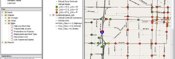


30 Intersection LOS Map 57 Link Volume and Speed 58 SE FL Model User Group, 7/1/08 29


31 Creating a Desire Lines Map 1. Open the output Mode Trips matrix 2. Open the output HW Loads network 3. From the Node menu, select Link to Matrix 4. Double-click on the Available Linkage and click Close 5. Go to Post > Desire Lines 6. Enter M1.T1.Car in Matrix Tables, 1000 in Scale, 5 in Org Exp, 1-25 in Dest Exp, and select 2-way 7. Click on the Display button to view desire lines 59 Path File Select Link Analysis 60 SE FL Model User Group, 7/1/08 30

32 Link Posting Selection Options 61 Node Posting Selection Options 62 SE FL Model User Group, 7/1/08 31


33 Node Color Specifications 63 Link Color Specifications 64 SE FL Model User Group, 7/1/08 32

34 Network Options 65 The roles of VPR and MXD files The Visual Project (VPR) file is still used in to track and store settings made in Cube 5, including: Line/Node/Area color and symbol sets Attribute posting and label symbol & style sets Selection sets Other network options A VPR is created for each MDB, with the same name as the MDB You can import settings from an existing VPR file for another MDB The MXD file is an ArcGIS-compatible map document, containing a snapshot of the current symbol style settings, with no link to VPR Changes stored in the VPR do not affect the MXD and vice versa! 66 SE FL Model User Group, 7/1/08 33


35 Share With GIS Staff You (or other GIS users) can also create maps for Cube 5 using ArcView 9.2. Add advanced elements such as multiple inset frames with extent rectangles or semi-transparent layers, and specify detailed symbol style and legend settings. Once your map is saved as an *.mxd file it can be opened in Cube 5 as well. 67 SE FL Model User Group, 7/1/08 34
Lesson 4: Training Model & User Interface Components
 Lesson 4: Training Model & User Interface Components 1 Infrastructure/Supply Data Highway Networks Intersection Data Transit Networks User/Demand Data Zonal Data Matrices Other Databases Visualization
Discover Cube 6.4 Tutorial
 Discover Cube 6.4 Tutorial Copyright 2007 2016 Citilabs, Inc. All rights reserved. Citilabs is a registered trademark of Citilabs, Inc. All other brand names and product names used in this book are trademarks,
INTRODUCTION TO CUBE
 INTRODUCTION TO CUBE 1 WELCOME TO CUBE... 2 1.1 OVERVIEW... 2 1.2 THE ARCHITECTURE OF CUBE... 3 1.3 THE CUBE USER ENVIRONMENT... 5 1.4 INTEGRATION WITH ARCGIS... 7 1.5 INTEGRATION OF THE CUBE EXTENSIONS...
Cube Base. Release Summary. Citilabs
 Cube Base Release Summary Cube Base Release Summary Citilabs Cube Base Release Summary This document describes features introduced in various versions of Cube Base. Sections include: Version 6.4.4 Version
Answer the following general questions: 1. What happens when you right click on an icon on your desktop? When you left double click on an icon?
 Name: Date: June 27th, 2011 GIS Boot Camps For Educators Practical: Explore ArcGIS 10 Desktop Tools and functionality Day_1 Lecture 1 Sources: o ArcGIS Desktop help o ESRI website o Getting to Know ArcGIS
Explore some of the new functionality in ArcMap 10
 Explore some of the new functionality in ArcMap 10 Scenario In this exercise, imagine you are a GIS analyst working for Old Dominion University. Construction will begin shortly on renovation of the new
Developers Road Map to ArcGIS Desktop and ArcGIS Engine
 Developers Road Map to ArcGIS Desktop and ArcGIS Engine Core ArcObjects Desktop Team ESRI Developer Summit 2008 1 Agenda Dev Summit ArcGIS Developer Opportunities Desktop 9.3 SDK Engine 9.3 SDK Explorer
Using the Geodatabase
 Using the Geodatabase February 13, 2002 Presented by: John Stroud, ESRI GeoDatabase Geodatabase comes in two flavors Personal mdb format ArcSDE rdbms format ArcGIS is a suite of three products ArcView,
What s s Coming in ArcGIS 10 Desktop
 What s s Coming in ArcGIS 10 Desktop Damian Spangrud ArcGIS Product Manager, ESRI dspangrud@esri.com (or at least turn to silent) ArcGIS 10 A Simple & Pervasive System for Using Maps & Geographic Information
Calculate a Distance Matrix of Locations along River Network
 Calculate a Distance Matrix of Locations along River Network These instructions enable you to measure the length of line segments between points, which is much more useful than simple straight-line distances
Review of File Management and Introduction to ArcGIS
 Review of File Management and Introduction to ArcGIS RNR/GEOG 417/517 Overview of Presentation Discuss the objectives of the lab exercise Introduce the class directory structure General file policies Introduce
ArcGIS Network Analyst and Network Dataset. Jim McKinney ESRI
 ArcGIS Network Analyst and Network Dataset Jim McKinney ESRI ArcGIS Network Analyst Everything in ArcView GIS 3x and more Routing Directions Network Analysis Tight Integration with Geoprocessing Models
Create a personal geodatabase
 Create a personal geodatabase To create a personal geodatabase that corresponds to the same release as the ArcGIS for Desktop client you are using, follow these steps: 1. In ArcCatalog, right-click the
FHWA GIS Safe Bike Routes Tools Version 4.0. User Guide
 FHWA GIS Safe Bike Routes Tools Version 4.0 User Guide Prepared for Federal Highway Administration Office of Safety Research and Development 6300 Georgetown Pike, T-203 McLean, VA 22101-2296 By 101 Walnut
4. If you are prompted to enable hardware acceleration to improve performance, click
 Exercise 1a: Creating new points ArcGIS 10 Complexity: Beginner Data Requirement: ArcGIS Tutorial Data Setup About creating new points In this exercise, you will use an aerial photograph to create a new
ArcGIS Basics Working with Labels and Annotation
 ArcGIS Basics Working with Labels and Annotation Labeling in ArcGIS has changed considerably from the old ArcView 3.X version. In ArcGIS label positions are generated automatically, are not selectable,
Creating Great Labels Using Maplex
 Esri International User Conference San Diego, CA Technical Workshops July 11 15, 2011 Creating Great Labels Using Maplex Craig Williams Natalie Vines 2 Presentation Overview What are the types of text
Finding and Using Spatial Data
 Finding and Using Spatial Data Introduction In this lab, you will download two different versions of the National Wetlands Inventory (NWI) dataset for a region of Massachusetts, from a source on the internet.
Schematics in ArcMap Tutorial
 Schematics in ArcMap Tutorial Copyright 1995-2010 Esri All rights reserved. Table of Contents Introducing Schematics in ArcMap Tutorial........................ 3 Exercise 1: Getting familiar with Schematics
LAB 1: Introduction to ArcGIS 8
 LAB 1: Introduction to ArcGIS 8 Outline Introduction Purpose Lab Basics o About the Computers o About the software o Additional information Data ArcGIS Applications o Starting ArcGIS o o o Conclusion To
Name: Date: June 27th, 2011 GIS Boot Camps For Educators Lecture_3
 Name: Date: June 27th, 2011 GIS Boot Camps For Educators Lecture_3 Practical: Creating and Editing Shapefiles Using Straight, AutoComplete and Cut Polygon Tools Use ArcCatalog to copy data files from:
for ArcSketch Version 1.1 ArcSketch is a sample extension to ArcGIS. It works with ArcGIS 9.1
 ArcSketch User Guide for ArcSketch Version 1.1 ArcSketch is a sample extension to ArcGIS. It works with ArcGIS 9.1 ArcSketch allows the user to quickly create, or sketch, features in ArcMap using easy-to-use
What's New in ArcGIS 9.2 Service Packs
 What's New in ArcGIS 9.2 Service Packs 18 July 2007 Updated for Service Pack 3 This document describes the main enhancements to 9.2 added by the service packs. It does not cover the bug fixes and quality
Tutorial 1: Finding and Displaying Spatial Data Using ArcGIS
 Tutorial 1: Finding and Displaying Spatial Data Using ArcGIS This tutorial will introduce you to the following: Websites where you may browse to find geospatial information Identifying spatial data, usable
What s New in Desktop 10.1
 What s New in Desktop 10.1 Damian Spangrud Esri Redlands Trip Down Memory Lane ArcGIS A Complete System for Geographic Information Cloud Web Online Mobile Enterprise Desktop Sharing Information sharing
Starting the QGIS Program. Exercise 1: Exploring QGIS
 Exercise 1: Exploring QGIS In this exercise you will learn how to open maps, manipulate layers, add spatial data, change symbols, and navigate within QGIS. You will also learn to repair broken data links.
What's New in ArcGIS 9.2 Service Packs
 What's New in ArcGIS 9.2 Service Packs 8 July 2008 Updated for Service Pack 6 This document describes the main enhancements to 9.2 added by the service packs. It does not cover the bug fixes and quality
Search & Rescue Map Specifications and Production Workflows
 Search & Rescue Map Specifications and Production Workflows About The Search & Rescue map product and production procedures discussed in this document can be utilized to support search, rescue, and relief
THE HONG KONG POLYTECHNIC UNIVERSITY DEPARTMENT OF LAND SURVEYING & GEO-INFORMATICS LSGI521 PRINCIPLES OF GIS
 THE HONG KONG POLYTECHNIC UNIVERSITY DEPARTMENT OF LAND SURVEYING & GEO-INFORMATICS LSGI521 PRINCIPLES OF GIS Student name: Student ID: Table of Content Working with files, folders, various software and
ArcGIS 9. Maplex Tutorial
 ArcGIS 9 Maplex Tutorial Copyright 004 006 ESRI All rights reserved. Printed in the United States of America. The information contained in this document is the exclusive property of ESRI. This work is
hereby recognizes that Timotej Verbovsek has successfully completed the web course 3D Analysis of Surfaces and Features Using ArcGIS 10
 3D Analysis of Surfaces and Features Using ArcGIS 10 Completed on September 5, 2012 3D Visualization Techniques Using ArcGIS 10 Completed on November 19, 2011 Basics of Map Projections (for ArcGIS 10)
GEOMEDIA SMART CLIENT 2016
 PRODUCT DESCRIPTION GEOMEDIA SMART CLIENT 2016 PRODUCT FEATURES AND COMPARISONS GeoMedia Smart Client enables the entire organization to access and utilize rich geospatial data in their business processes.
ArcView QuickStart Guide. Contents. The ArcView Screen. Elements of an ArcView Project. Creating an ArcView Project. Adding Themes to Views
 ArcView QuickStart Guide Page 1 ArcView QuickStart Guide Contents The ArcView Screen Elements of an ArcView Project Creating an ArcView Project Adding Themes to Views Zoom and Pan Tools Querying Themes
What is Network Analyst?
 What is Network Analyst? Extension for analyzing transportation networks Four network solvers Route Closest Facility Service Area Uses Network Datasets Origin-Destination (OD) Cost Matrix Specialized layers
Introduction to ArcGIS I
 Introduction 1-1 What is ArcGIS? ArcGIS Clients ArcReader E X T E N S I O N S ArcGIS Desktop ArcView ArcEditor ArcInfo ArcGIS Engine ArcPad Custom Application E X T E N S I O N S Web Browser Components
ArcMap: Tips and Tricks
 Esri International User Conference San Diego, California Technical Workshops July 23 27, 2012 ArcMap: Tips and Tricks Miriam Schmidts Jorge Ruiz-Valdepena Agenda Navigating ArcMap Repairing data links
Map Library ArcView Version 1 02/20/03 Page 1 of 12. ArcView GIS
 Map Library ArcView Version 1 02/20/03 Page 1 of 12 1. Introduction 1 ArcView GIS ArcView is the most popular desktop GIS analysis and map presentation software package.. With ArcView GIS you can create
Step by Step GIS. Section 1
 Step by Step GIS Section 1 Contact the web page given below for the data required to do the exercises (http://www.pasda.psu.edu/default.asp) Before beginning the tutorials please visit the Preparation
Introduction to Geodatabase and Spatial Management in ArcGIS. Craig Gillgrass Esri
 Introduction to Geodatabase and Spatial Management in ArcGIS Craig Gillgrass Esri Session Path The Geodatabase - What is it? - Why use it? - What types are there? - What can I do with it? Query Layers
Cartographic Techniques and Representations
 Cartographic Techniques and Representations NEARC 2007 ESRI Technical Session ESRI, Boston Overview of Presentation Labeling and Annotation Masking Layout Tips Cartographic Representations Labeling versus
In this exercise, you will convert labels into geodatabase annotation so you can edit the text features.
 Instructions: Use the provided data stored in a USB. For the report: 1. Start a new word document. 2. Follow an exercise step as given below. 3. Describe what you did in that step in the word document
دورة تدريبية عن تطبيقات برنامج ARC GIS
 دورة تدريبية عن تطبيقات برنامج ARC GIS مايو 2009 دورة تدريبيت عن تطبيقاث برنامج ARC GIS 2009 مايو Table of Contents Introduction... viii Module 1: Introduction to ArcGIS 9 Module Objectives... 1-1 ArcGIS
Spatial Manager- version 4.0 User Guide
 Exor Corporation Limited Spatial Manager- version 4.0 User Guide The Global Leader in Infrastructure Asset Management Copyright Exor Corporation Ltd, England, 2006 All rights reserved 1 This page intentionally
Lesson 8 : How to Create a Distance from a Water Layer
 Created By: Lane Carter Advisor: Paul Evangelista Date: July 2011 Software: ArcGIS 10 Lesson 8 : How to Create a Distance from a Water Layer Background This tutorial will cover the basic processes involved
Geographical Information Systems Institute. Center for Geographic Analysis, Harvard University. LAB EXERCISE 1: Basic Mapping in ArcMap
 Harvard University Introduction to ArcMap Geographical Information Systems Institute Center for Geographic Analysis, Harvard University LAB EXERCISE 1: Basic Mapping in ArcMap Individual files (lab instructions,
Editing Versioned Geodatabases : An Introduction
 Esri International User Conference San Diego, California Technical Workshops July 24, 2012 Editing Versioned Geodatabases : An Introduction Cheryl Cleghorn Shawn Thorne Assumptions: Basic knowledge of
Annotation/Labeling Workshop. Tim Rankin Pat Dolan
 Annotation/Labeling Workshop Tim Rankin Pat Dolan Agenda 8:00am - Introductions 8:05am - Goals of the Workshop 8:15am Labeling 8:45am Annotation Part I 9:15am Break 9:25am Annotation Part II 9:50am Questions
What s New in ArcGIS Server 10
 What s New in ArcGIS Server 10 Derek Law ArcGIS Server Product Management What s s new in ArcGIS Server 10? Agenda Highlights: Enhanced Web mapping More powerful server-based analysis Geo-collaboration
Quick Guide to MapWindow GIS Desktop Application
 Quick Guide to MapWindow 1 Quick Guide to MapWindow GIS Desktop Application Version 2 January 2007 Adapted by Tom Croft. This is a summary user guide for commonly used tools and capabilities and does not
Overview. Review. GEOL 452/552 - GIS for Geoscientists I. Lecture 4. what is a feature class? What is georeferenced Data? what are layers?
 GEOL 452/552 - GIS for Geoscientists I Lecture 4 Overview Tutorial and HW 1 went OK? Today Review of concepts from last lecture Scales Labels ArcMap follow-along tour More material about ArcMap in WebCT
ArcGIS 10.1 for Desktop Artie Robinson
 ArcGIS 10.1 for Desktop Artie Robinson ArcGIS A Complete System for Geographic Information Cloud Web Online Mobile Enterprise Desktop Name Change Name Prior to 10.1 ArcGIS Desktop ArcInfo ArcEditor ArcView
Introduction to ArcCatalog
 Introduction to ArcCatalog Introduction To Arc Catalog ArcCatalog is a data- centric GUI tool used for managing spatial data With ArcCatalog you can. Inspect properties and attributes of data Preview and
ArcGIS Schematics: Automatic Schematic Generation for ArcGIS
 ArcGIS Schematics: Automatic Schematic Generation for ArcGIS An ESRI White Paper May 2005 ESRI 380 New York St., Redlands, CA 92373-8100, USA TEL 909-793-2853 FAX 909-793-5953 E-MAIL info@esri.com WEB
Key Terms. Attribute join Target table Join table Spatial join
 Key Terms Attribute join Target table Join table Spatial join Lect 10A Building Geodatabase Create a new file geodatabase Map x,y data Convert shape files to geodatabase feature classes Spatial Data Formats
Getting to Know ModelBuilder
 Getting to Know ModelBuilder Offered by Shane Bradt through the UNH Cooperative Extension Geospatial Technologies Training Center Developed by Sandy Prisloe and Cary Chadwick at the Geospatial Technology
ArcCatalog or the ArcCatalog tab in ArcMap ArcCatalog or the ArcCatalog tab in ArcMap ArcCatalog or the ArcCatalog tab in ArcMap
 ArcGIS Procedures NUMBER OPERATION APPLICATION: TOOLBAR 1 Import interchange file to coverage 2 Create a new 3 Create a new feature dataset 4 Import Rasters into a 5 Import tables into a PROCEDURE Coverage
Exercise 1: An Overview of ArcMap and ArcCatalog
 Exercise 1: An Overview of ArcMap and ArcCatalog Introduction: ArcGIS is an integrated collection of GIS software products for building a complete GIS. ArcGIS enables users to deploy GIS functionality
Viewing the Data 3 Turning Layers On / Off 4 Navigation Toolbar 5 Layout Toolbar 7 Identify Tool 8 Find Tool 10 Measure Tool 12 Go To XY Tool 14
 1 Viewing the Data 3 Turning Layers On / Off 4 Navigation Toolbar 5 Layout Toolbar 7 Identify Tool 8 Find Tool 10 Measure Tool 12 Go To XY Tool 14 Transparency Tool 16 Markup Tools 19 ArcMap Markup Tools
ArcGIS Extension User's Guide
 ArcGIS Extension 2010 - User's Guide Table of Contents OpenSpirit ArcGIS Extension 2010... 1 Installation ( ArcGIS 9.3 or 9.3.1)... 3 Prerequisites... 3 Installation Steps... 3 Installation ( ArcGIS 10)...
Visualization with ArcGlobe. Brady Hoak
 Visualization with ArcGlobe Brady Hoak Contents What is ArcGlobe? 3D Mapping and ArcGlobe Displaying data in ArcGlobe ArcGlobe tools Tips for constructing ArcGlobe documents New at ArcGIS 9.3 ArcGIS integration
Configuring, Tuning and Managing ArcGIS Server. Dan O Leary James Cardona Owen Evans
 Configuring, Tuning and Managing ArcGIS Server Dan O Leary James Cardona Owen Evans Introductions and Overview Welcome and Thanks for Attending Approach of this Session Share Best Practices and Techniques
CSTools Guide (for ArcGIS version 10.2 and 10.3)
") CSTools Guide (for ArcGIS version 10.2 and 10.3) 1. Why to use Orientation Analysis and Cross section tools (CSTools) in ArcGIS? 2 2. Data format 2 2.1 Coordinate Systems 2 3. How to get the tools into
CSTools Guide (for ArcGIS version 10.2 and 10.3) 1. Why to use Orientation Analysis and Cross section tools (CSTools) in ArcGIS? 2 2. Data format 2 2.1 Coordinate Systems 2 3. How to get the tools into
Using ESRI data in Autodesk ISD Products
 GI13-3 Using ESRI data in Autodesk ISD Products 1.5 hr. Class 02-Dec-03 3:30pm - 5:00pm Session Description: We will focus on using data in a variety of ESRI formats within the Autodesk GIS product line,
Using ArcGIS. Tracking Analyst. GIS by ESRI
 Using ArcGIS Tracking Analyst GIS by ESRI Copyright 2002 ESRI All Rights Reserved Printed in the United States of America The information contained in this document is the exclusive property of ESRI This
TRAINING GUIDE. GIS Editing Tools for ArcGIS Desktop
 TRAINING GUIDE GIS Editing Tools for ArcGIS Desktop Editing Tools for ArcGIS Desktop Lucity GIS contains an editor extension that tracks edits made to the Lucity GIS geodatabase and ensures that those
ArcGIS Desktop: Introduction to Geoprocessing with ModelBuilder Kevin Armstrong ESRI
 ArcGIS Desktop: Introduction to Geoprocessing with ModelBuilder Kevin Armstrong ESRI SERUG 2008 1 What is ModelBuilder? A user-friendly way to automate a series of tools Part of the ArcGIS geoprocessing
Measuring the Lengths of Receiving Polygon Edges
 Measuring the Lengths of Receiving Polygon Edges These instructions enable you to create shapefiles that represent the edge along a receiving polygon that may then be used in the analysis of potential
QGIS Workshop Su Zhang and Laura Gleasner 11/15/2018. QGIS Workshop
 1. Introduction to QGIS QGIS Workshop QGIS is a free and open source Geographic Information System (GIS). QGIS can help users create, edit, visualize, analyze, and publish geospatial information on various
GEOMEDIA SMART CLIENT 2015 PRODUCT FEATURES AND COMPARISONS
 GEOMEDIA SMART CLIENT 2015 PRODUCT FEATURES AND COMPARISONS GeoMedia Smart Client enables the entire organization to access and utilize rich geospatial data in their business processes. It delivers an
Carlson GIS for Surveyors
 Professional Land Surveyors of Ohio 2016 Annual Conference -- Dayton Ohio Carlson GIS for Surveyors Presented by Who Is That CAD Girl? Jennifer DiBona is a long time CAD consultant and trainer doing business
MAPLOGIC CORPORATION. GIS Software Solutions. Getting Started. With MapLogic Layout Manager
 MAPLOGIC CORPORATION GIS Software Solutions Getting Started With MapLogic Layout Manager Getting Started with MapLogic Layout Manager 2011 MapLogic Corporation All Rights Reserved 330 West Canton Ave.,
Welcome to NR402 GIS Applications in Natural Resources. This course consists of 9 lessons, including Power point presentations, demonstrations,
 Welcome to NR402 GIS Applications in Natural Resources. This course consists of 9 lessons, including Power point presentations, demonstrations, readings, and hands on GIS lab exercises. Following the last
GIS Intro for G&G 304
 Geog_And_Epid.Doc Page 1 of 21 GIS Intro for G&G 304 Objectives By the end of this tutorial, you should understand: How to Open spatial data in ArcMap How to create a spatial data layer from tabular coordinates
Linear Referencing in ArcGIS. GIS by ESRI
 Linear Referencing in ArcGIS GIS by ESRI Copyright 00 ESRI All rights reserved. Printed in the United States of America. The information contained in this document is the exclusive property of ESRI. This
Introduction to ArcSDE 8. John Calkins
 Introduction to ArcSDE 8 John Calkins Why are you here? Introduction to ArcSDE? What is a GeoDatabase? Existing SDE user? Existing ArcInfo user? Technical details on implementation? Just confused... ArcSDE
SilvAssist 3.5 Instruction Manual Instruction Manual for the SilvAssist Toolbar For ArcGIS. Version 3.5
 Instruction Manual for the SilvAssist Toolbar For ArcGIS Version 3.5 1 2 Contents Introduction... 5 Preparing to Use SilvAssist... 6 Polygon Selection... 6 Plot Allocator... 7 Requirements:... 7 Operation...
Using ArcScan for ArcGIS
 ArcGIS 9 Using ArcScan for ArcGIS Copyright 00 005 ESRI All rights reserved. Printed in the United States of America. The information contained in this document is the exclusive property of ESRI. This
IntraMaps End User Manual
 IntraMaps End User Manual For IntraMaps Version 8 Date: 6 th July 2014 Contents Introduction... 4 What is IntraMaps?... 4 Application... 5 Main Toolbar... 6 View... 7 Original View:... 7 Pan:... 7 Zoom
Measuring Area/Length of Organisms with GIS
 Measuring Area/Length of Organisms with GIS These instructions enable you to measure the length and area of microscopic organisms in ArcGIS from digital photographs. The four-step process involves: georeferencing
Integrating CAD Data with ArcGIS
 Integrating CAD Data with ArcGIS Agenda An Overview of CAD Drawings CAD Data Structure in ArcGIS Visualization Georeferencing Data Conversion ArcGIS for AutoCAD Q & A CAD Drawings - Overview Widely used
Converting the Roads & Highways Advanced LRS to a Routable Network. Eric J. Rodenberg
 Converting the Roads & Highways Advanced LRS to a Routable Network Eric J. Rodenberg Agenda The ArcGIS Platform Roads and Highways Network Datasets Roads and Highways Events Converting the LRS to a Network
GIS Workbook #1. GIS Basics and the ArcGIS Environment. Helen Goodchild
 GIS Basics and the ArcGIS Environment Helen Goodchild Overview of Geographic Information Systems Geographical Information Systems (GIS) are used to display, manipulate and analyse spatial data (data that
Using ArcGIS. Tracking Analyst. GIS by ESRI
 Using ArcGIS Tracking Analyst GIS by ESRI Copyright (c) 2002 TASC, Inc. and its licensor(s). All Rights Reserved. Printed in the United States of America. The information contained in this document is
INTRODUCTION TO GIS WORKSHOP EXERCISE
 111 Mulford Hall, College of Natural Resources, UC Berkeley (510) 643-4539 INTRODUCTION TO GIS WORKSHOP EXERCISE This exercise is a survey of some GIS and spatial analysis tools for ecological and natural
GIS Basics for Urban Studies
 GIS Basics for Urban Studies Date: March 21, 2018 Contacts: Mehdi Aminipouri, Graduate Peer GIS Faciliator, SFU Library (maminipo@sfu.ca) Keshav Mukunda, GIS & Map Librarian Librarian for Geography (kmukunda@sfu.ca)
Getting the most from the Maplex Label Engine
 Esri International User Conference San Diego, California Technical Workshops July 26, 2012 Getting the most from the Maplex Label Engine Craig Williams Natalie Matthews 2 Presentation Overview What are
MIGRATING AV 3.X TO AV 8.X? Jaishankar J, Md Jafrullah, Arindam Basu
 MIGRATING AV 3.X TO AV 8.X? Jaishankar J, Md Jafrullah, Arindam Basu Abstract ArcGIS suite the latest architectural re-structuring of the gamut of ESRI products under a single umbrella is a unique convergence.
Display Layers in Geosoft 3D View
 Use the New 2D/3D Workflow features in Target for ArcGIS In Target for ArcGIS version 3.5, there are three new interconnected features that make integrating 2D and 3D data in plan and section maps easier.
What's New at ArcPad 6
 What's New at ArcPad 6 An ESRI White Paper April 2002 ESRI 380 New York St., Redlands, CA 92373-8100, USA TEL 909-793-2853 FAX 909-793-5953 E-MAIL info@esri.com WEB www.esri.com Copyright 2002 ESRI All
Exercise 1: Getting to know ArcGIS
 The Scenario You are working for the California Visitor s Commission. You have been asked to prepare a map of California for several dignitaries from out of the country. Your map will need to include enough
Getting Started With LP360
 Getting Started With LP360 12/22/2015 1 Contents What is LP360?... 3 System Requirements... 3 Installing LP360... 4 How to Enable the LP360 Extension... 4 How to Display the LP360 Toolbar... 4 How to Import
MapInfo Professional Evolution!
 MapInfo Professional Evolution! A long history of improvement This presentation covers what is new in all of the MapInfo Pro releases since v9.0! MapInfo Pro Release History A feature release every year
Streamlining Editing Workflows. Amber Bethell
 Streamlining Editing Workflows Amber Bethell Workflow for solving geographic problems Ask a question Create or acquire data Validate and update data Analyze data Create cartographic product Act upon knowledge
Chapter 5. Presenting Data
 Chapter 5. Presenting Data Copyright McGraw-Hill Education. Permission required for reproduction or display. 5-1 Map Design Process 5-2 1 About ArcGIS Chapter 5. Presenting Data 5-3 Page layouts and map
ICIT. Brian Hiller ESRI Account Manger. What s new in ArcGIS 10
 ICIT Brian Hiller ESRI Account Manger What s new in ArcGIS 10 ArcGIS 10 Fast Easy Powerful Everywhere late June 2010 ArcGIS System for Geographic Information Desktop Server Mobile Online A System A Complete
Raster Serving with ArcGIS
 Raster Serving with ArcGIS Agenda Introduction to server technology Workflow considerations ESRI raster serving technology ArcGIS Server Basic (ArcSDE) ArcGIS Server Standard/Advanced Web Services ArcGIS
Store and Manage Data in a DBMS With ArcView Database Access. Presented By: Andrew Arana & Canserina Kurnia
 Store and Manage Data in a DBMS With ArcView Database Access Presented By: Andrew Arana & Canserina Kurnia Overview Topics to be Covered: General method for accessing data database themes, database tables
TIBCO OpenSpirit Extension for ArcGIS User Guide
 TIBCO OpenSpirit Extension for ArcGIS User Guide Software Release 2010.1.0 August 2012 ii Important Information SOME TIBCO SOFTWARE EMBEDS OR BUNDLES OTHER TIBCO SOFTWARE. USE OF SUCH EMBEDDED OR BUNDLED
Priming the Pump Stage II
 Priming the Pump Stage II Modeling and mapping concentration with fire response networks By Mike Price, Entrada/San Juan, Inc. The article Priming the Pump Preparing data for concentration modeling with
GIS OPERATION MANUAL
 GIS OPERATION MANUAL 1. Computer System Description Hardware Make Compaq Presario 5004 CPU AMD Athlon 1.1 Ghz Main Memory 640MB CD-ROM 52 X CD-RW 8 X HD 57GB Monitor 19 inch Video Adapter 16 Mb Nvidia