Lesson 4: Training Model & User Interface Components
|
|
|
- Anis Goodwin
- 6 years ago
- Views:
Transcription
1 Lesson 4: Training Model & User Interface Components 1
2 Infrastructure/Supply Data Highway Networks Intersection Data Transit Networks
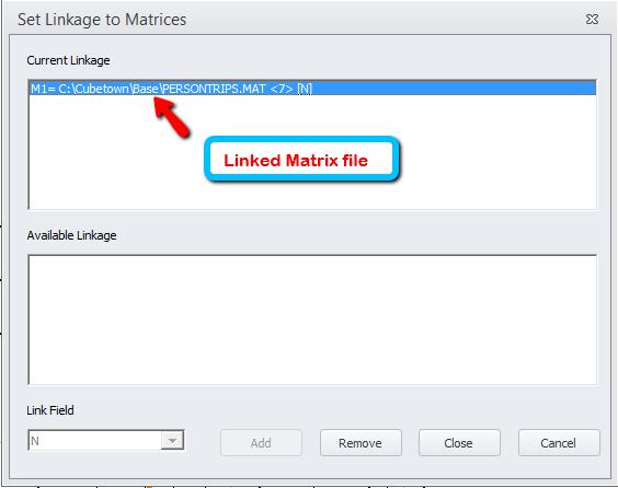
3 User/Demand Data Zonal Data Matrices Other Databases
4 Visualization Environments Visual Project File - VPR ArcView Map Document File MXD


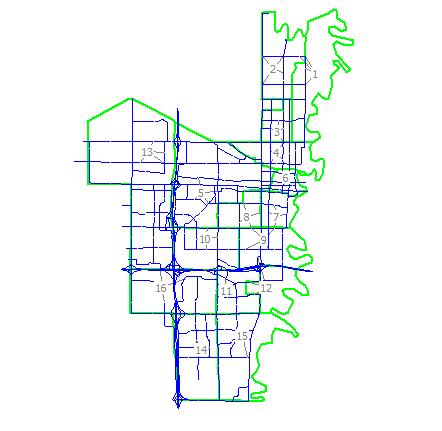
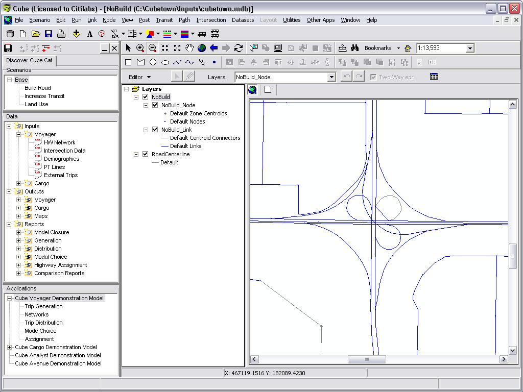
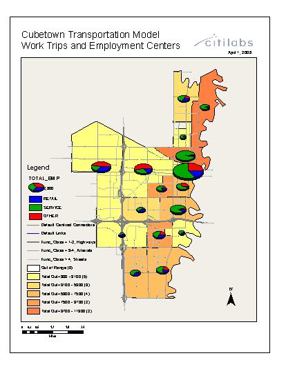
5 Review of Cubetown Training Model

 Also available: Applying the")
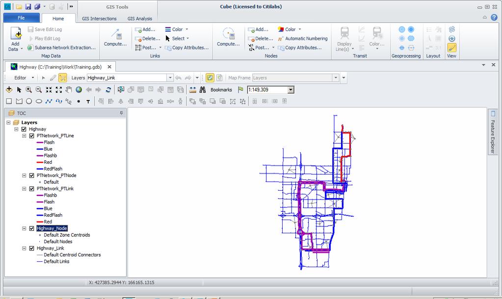
6 Review of Cubetown Training Model (cont d) Cube Voyager Demo Model 25-zone four-step Voyager passenger demand forecasting model with feedback to trip distribution (Internal zones = 1-16) Also available: Applying the forecasting system


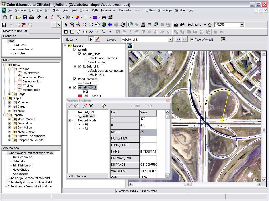
7 Roadway Centerline Data Usually provided in ESRI shapefile or geodatabase feature class format Cube Requirements:


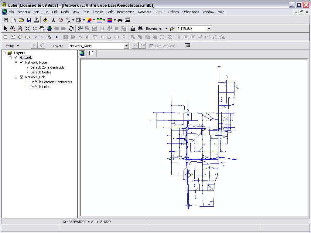
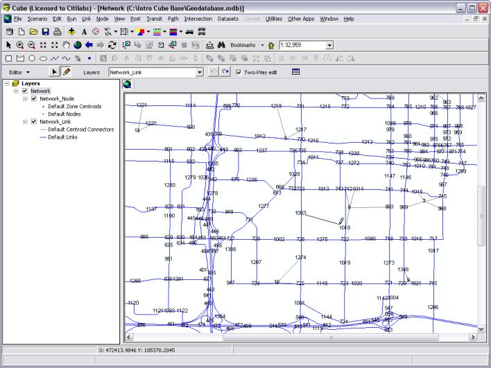
8 The Network Window Displays a network and other layers Menu commands and toolbar buttons configure display Settings are stored in a VPR file (Visual Project)
9 Network Toolbar & Core Function Pointer (Shift+F7) Undo Last Edit Change (Shift+Z) Zoom in / zoom out Zoom all Previous view Pan Resize Plot page Center on Nodes Refresh Current View
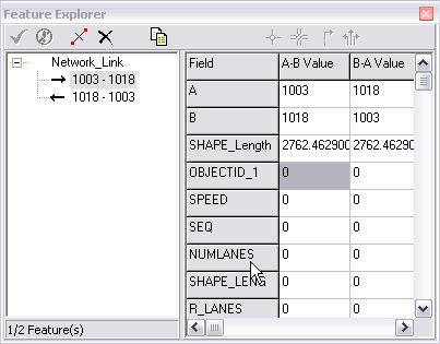
10 Navigating the View Legend Layer Control Select Top Layer Display Layer Information Browse Link Table Browse Node Table Bookmarks More Buttons

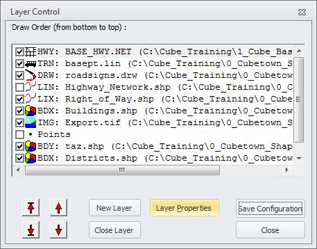
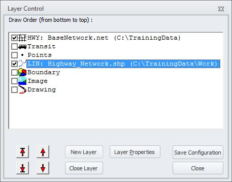
11 Layer Control


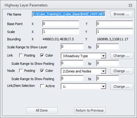
12 Layer Parameters (Properties)


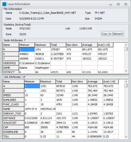
13 Display Layer Information


14 File > Options > NET/GIS > Network Window


15 Layer Parameters > Link Posting


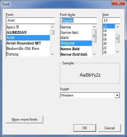
16 Changing Font Size for Link Post Or, use File > Options >General > Font


17 Node Posting


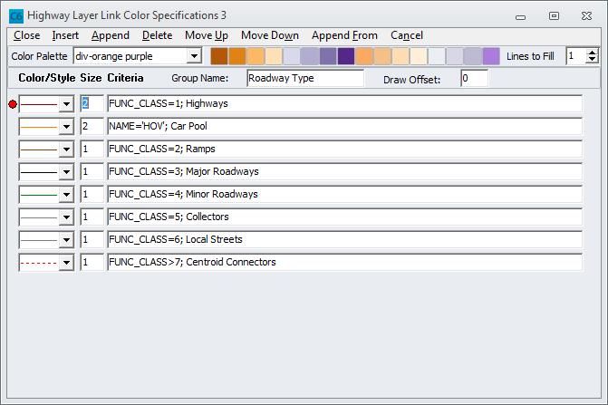
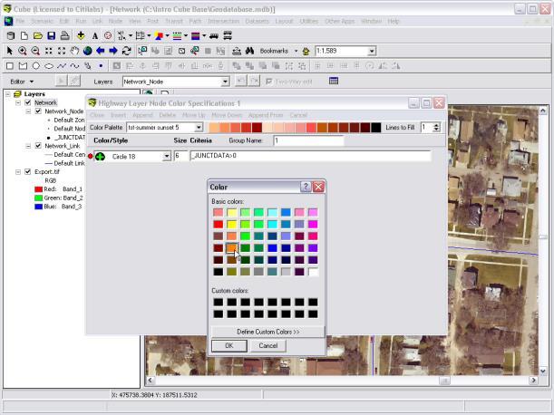
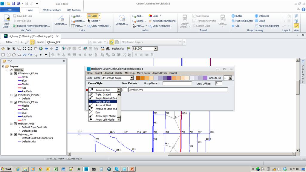
18 Link Color Specification


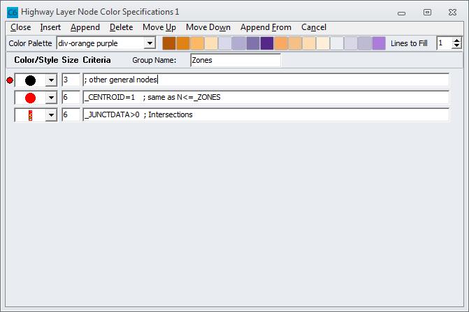
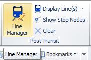
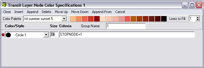
19 Node Color Specification

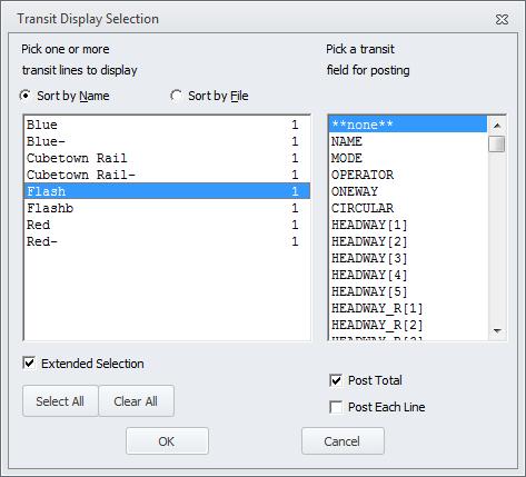
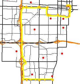
20 Boundary Layer Settings 3 2 1


21 Creating a new Log File 1 Log Files (1/2)
 Save")

22 Log Files (2/2) Save Edit Log Play Edit Log

23 Building Paths using Path File (1/2)


24 Building Paths using Path File (2/2)
25 Select Link Analysis using Path File (1/2)


26 Select Link Analysis using Path File (2/2)


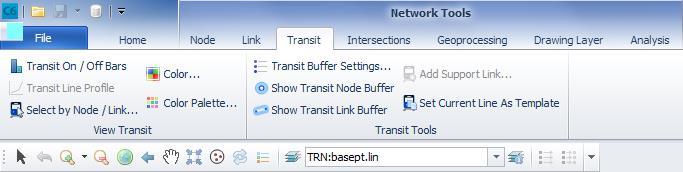
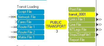
27 Transit Line Manager

28 Transit Display Lines

29 Transit Stops/Non-Stops Show Stop/Non-Stop Nodes


30 Transit Display Settings Color Color Palette

31 Transit Buffers Stop

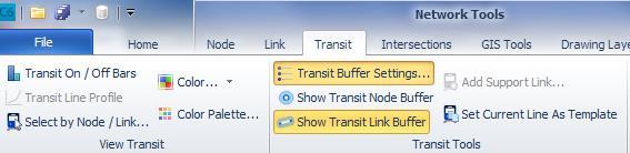
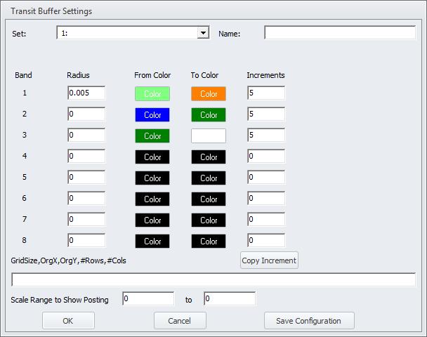
32 Transit Buffers Link

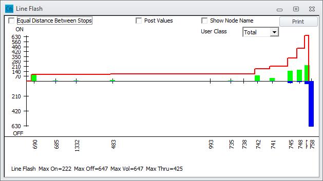
33 Transit On/Off Bar

34 Transit Line Profile


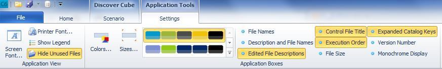
35 Building Paths using Transit Route File (1/2)

36 Building Paths using Transit Route File (2/2)

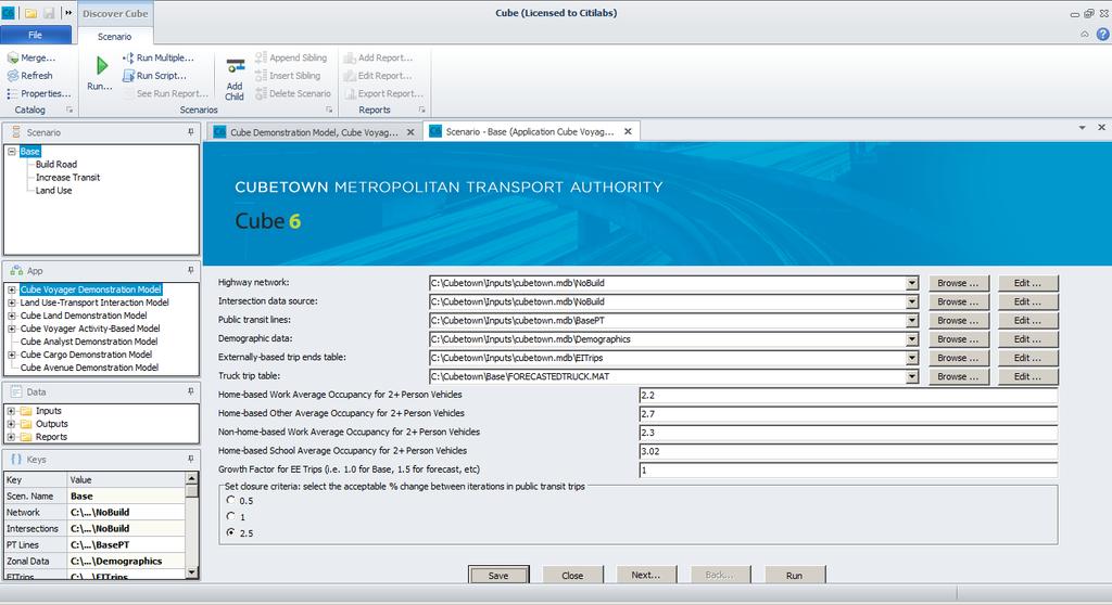
37 Scenario Manager Merge Refresh Properties Run Run Multiple Run Script See Run Report Add child
38 Merging Catalogs (1/2)


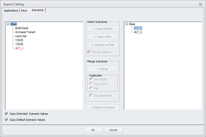
39 Merging Catalogs (2/2)
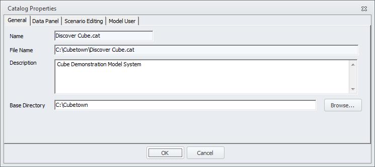
40 Catalog Properties

41 Scenario Manager Settings

42 Changing Font Size for Docking Windows

43 Application Information Application Tools > Application Options > Application Information


44 Application View Screen Font - Printer Font - Show Legend - Hide Unused Files -
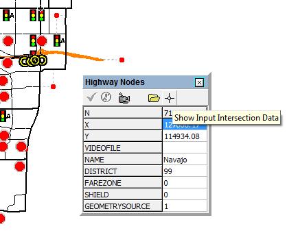
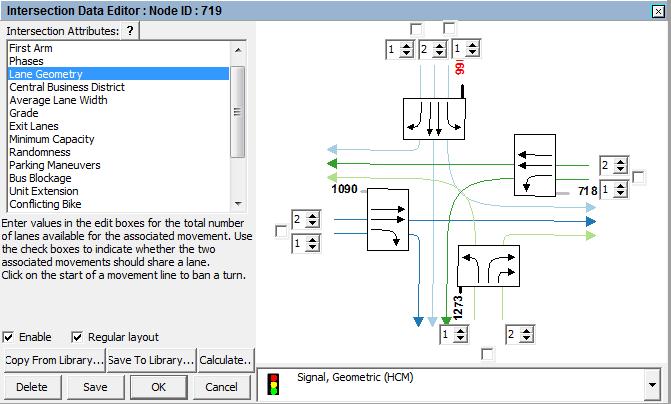
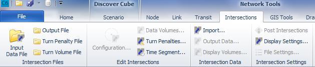
45 Application Boxes Color - Sizes - File Names - Description and File Names - Edited File Descriptions - Control File Title -
46 Application Tools (Home ribbon tab) Process Templates - Auto Name Files - Create External Files - Delete Output Files - Add to Catalog Data - Interactive Order Check - Redraw -.


47 How to add application group from another catalog (1/2)


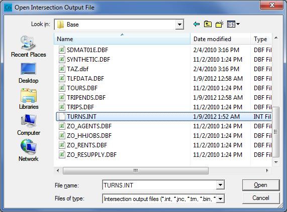
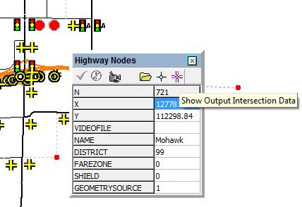
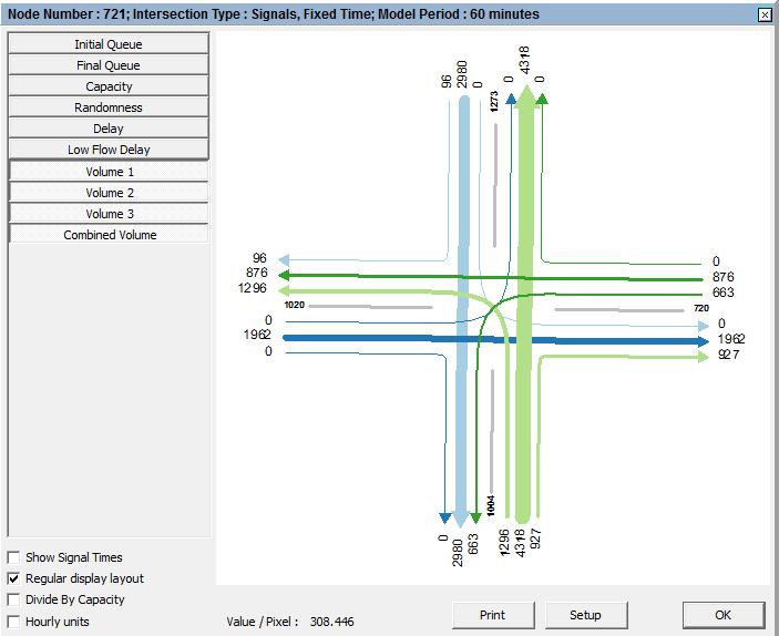
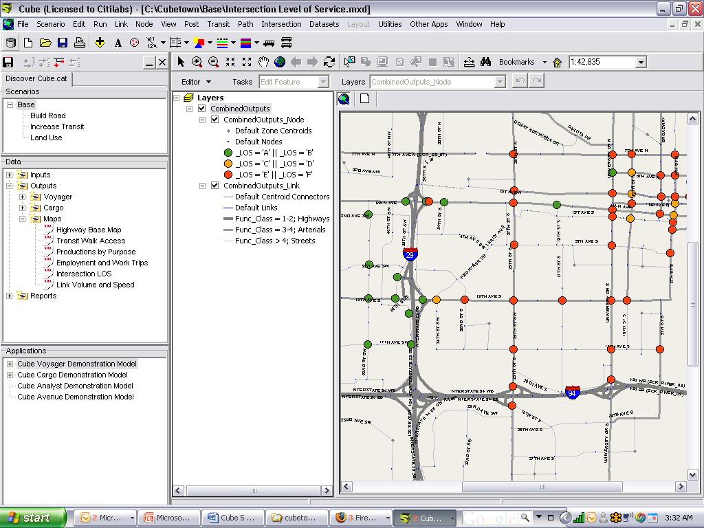
48 How to add application group from another catalog (2/2)


49 Node Charts 1 3 Sample Node Chart 2


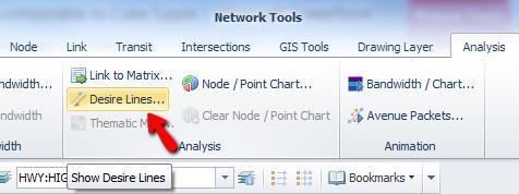

50 Desire Lines (1/2)


51 Desire Lines (2/2) 5 Enter the inputs as follows: Select Display 6 Desired Lines

")
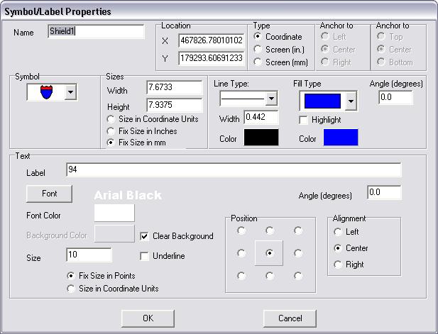
52 Coding Turn Penalty (1/2)


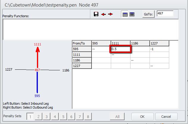
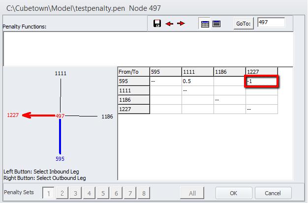
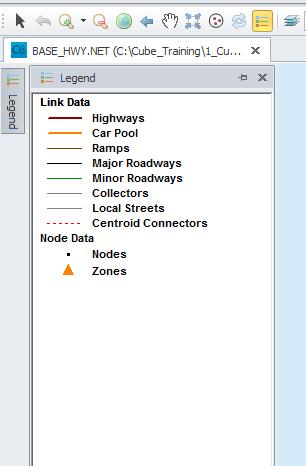
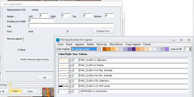
53 Turn Penalty in Cube is coded as: To Code penalties: Specify the values in the appropriate boxes Coding Turn Penalty (2/2) Penalty in Cost Prohibited

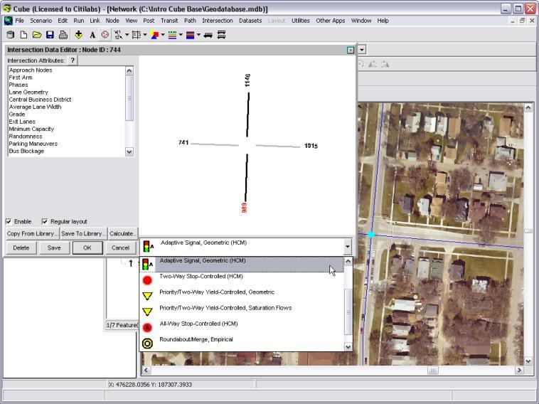
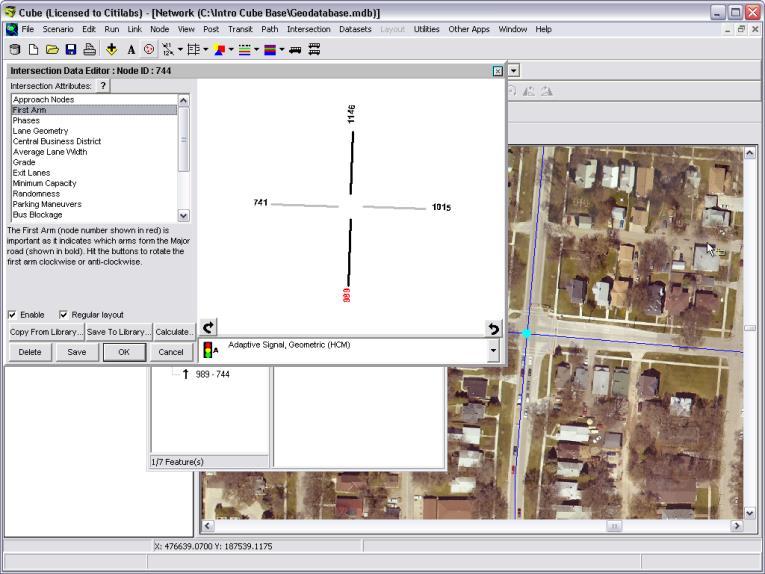
54 Intersection View Input Data (1/3)
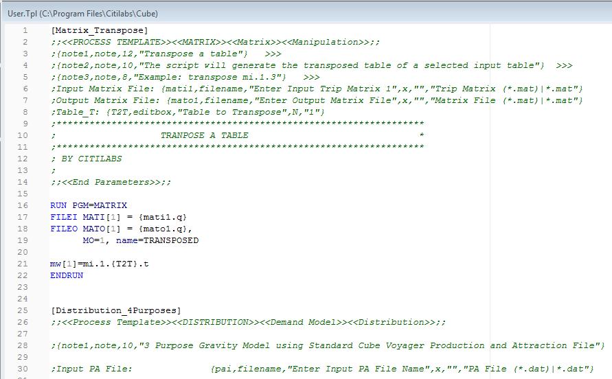
55 Intersection View Input Data (2/3)
56 Intersection View Input Data (3/3)
57 Intersection View Output Data (1/3)
58 Intersection View Output Data (2/3)
59 Intersection View Output Data (3/3)


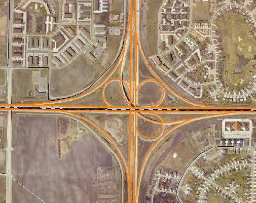
60 True Shape Display Before After True Shape Display ON


61 Drawing / Screenline Layer Contains view annotation elements Drawing > New Object to create Use pointing mode to position & resize Save file when done


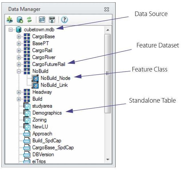
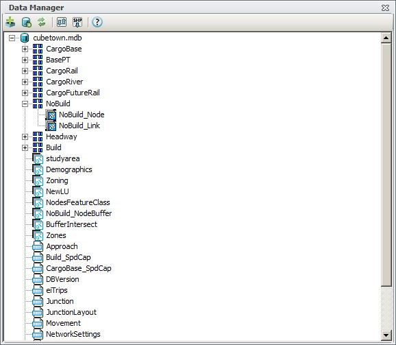
62 Create Highway Shield 1. 2.


63 Legend Setup


64 Print, Page and Legend Setup
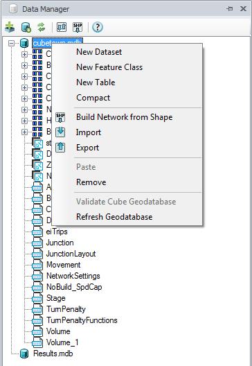
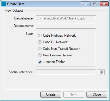
65 Creating User Templates 1. Open your user template script file in Cube Base 2. Go to File>>Tools>>User Templates 3. Select *** Add New Template *** 4. Enter new template name.


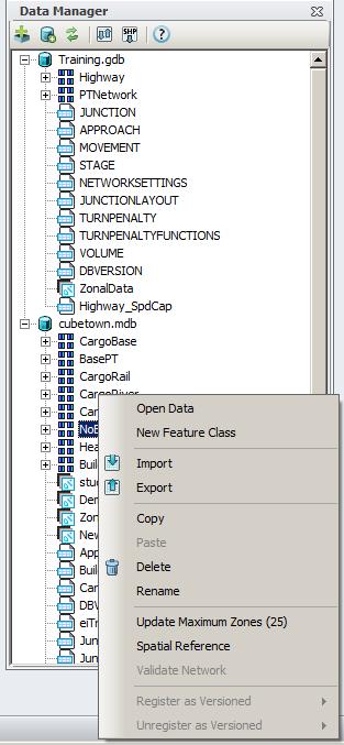
66 Running Module Templates Module Templates can be accessed by the following means
67 Example of User Templates (1/5)

")
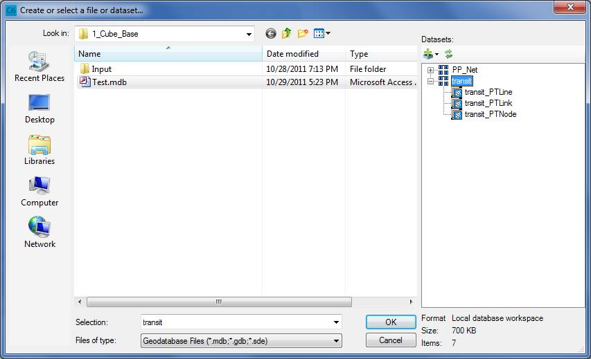
68 Example of User Templates (2/5)

")
69 Example of User Templates (3/5)
")
70 Example of User Templates (4/5)

")


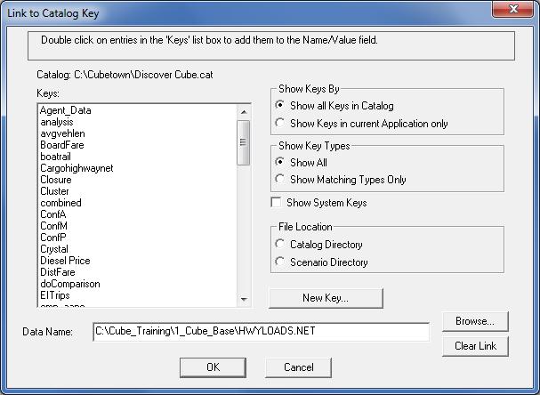
71 Example of User Templates (5/5)


72 New Data Manager Interface in Cube 6
73 Anatomy of Data Manager Toolbar buttons Add Data Create Geodatabase Refresh Workspaces Import/Export Data Build Network From Shape Help Workspace
74 Workspace


75 New Dataset Geodatabase Command Menu New Feature Class New Table Compact Build Network from Shape Import, Export Remove Validate Cube Geodatabase


")
76 Feature Data Set Command Menu Open Data New Feature Class Import, Export Copy Delete Rename Update Maximum Zones (#) Spatial Reference

77 Open the Data Manager
78 Create a new geodatabase 1 3 2

79 Import data


80 Import Highway Network with True Shape

81 Import Transit Lines
82 Import Zonal Layer (TAZ.shp)

83 Import Junction Tables

84 Import dbase Table
85 Geodatabases in Model Catalogs Cube provides two complimentary ways to organize and store model information: The Model Catalog is a file that tracks the location and model function of other files within the main (root level) model folder. The Geodatabase is a file that acts as a container for any geographic data that are used within the model and related maps.

86 Link input networks


87 Output network with restored geometry

88 Make GDB outputs scenario-specific 1 3 2

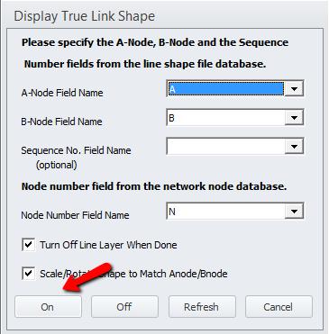
89 Output transit assignment to GDB
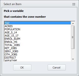
90 GIS Toolbar GIS Window Components View Switcher Editing Toolbar Graphics Toolbar Table of Contents Data View Tips & Messages
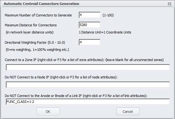
91 GIS Toolbar (1/2)
92 GIS Toolbar (2/2)
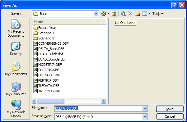
93 Graphics Toolbar (1/3)
94 Graphics Toolbar (2/3)
95 Graphics Toolbar (3/3)
96 Floating Toolbars GIS Editor Sub-Toolbar
97 Floating Toolbars GIS Layout Sub-Toolbar
98 Layout Toolbar
99 Lesson 5: Working with Cube Base + GIS Window + Data preparation 99
100 Working with Cube GIS Exercises
101 Exercise 1: Build Network From Feature Class (Shape)

102 Important Options to Consider A point layer can be used to specify node locations The level field allows you to set which lines connect Directional data stored in field pairs can be used A, B node numbers are not always required on input


103 Overlay Network on Polyline Shapefile


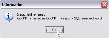
104 Turn On True Shape Display On the GIS Tools tab, click on the True Shape Display button


105 Exercise 2a: Develop Centroid Locations


106 Exercise 2b: Develop Centroid Connectors

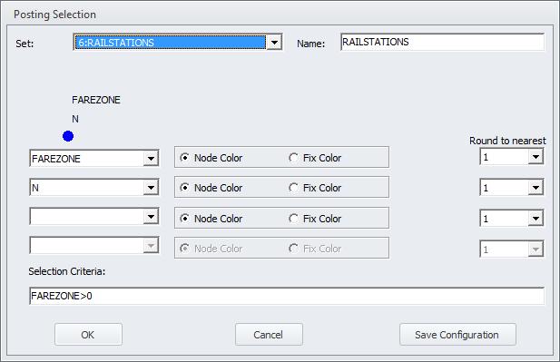
107 Network Options
108 Saving Your Work The Visual Project File: Close the Network Window and save the Network.NET file as well as a Project File


109 Exercise 2c: Consolidate Links With Same Attributes Typically, roadway centerlines have many nodes that are not junctions less efficient Cube can identify strings of links that have the same attributes and consolidate them Set the attributes that determine calculation of link speed and capacity to Must Match Note: Sequence field in True Shape relationship will be updated accordingly

110 Sequences & Generate True Shape Equivalency A Sequence field allows you to have multiple shapes per network link Note that you can also generate true shape equivalencies, which performs the following:


111 Modify Shape Database Structure Add a Sequence field for true shape
112 Saving Your Work
113 Moving to Cube GIS Working with Cube Geodatabase files Working with Cube GIS

114 Open the Data Manager

115 Exercise 3: Create a new geodatabase

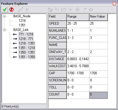
116 Exercise 4: Import data

117 Import additional data Public Transit Zonal Data DBF Tables Junction Data

118 Junction tables


119 Automatic Import Checks SQL reserved words to avoid:


120 Storing the Network in a Geodatabase

121 Link Posting Selection Options

122 Node Posting Selection Options
123 Node Color Specifications
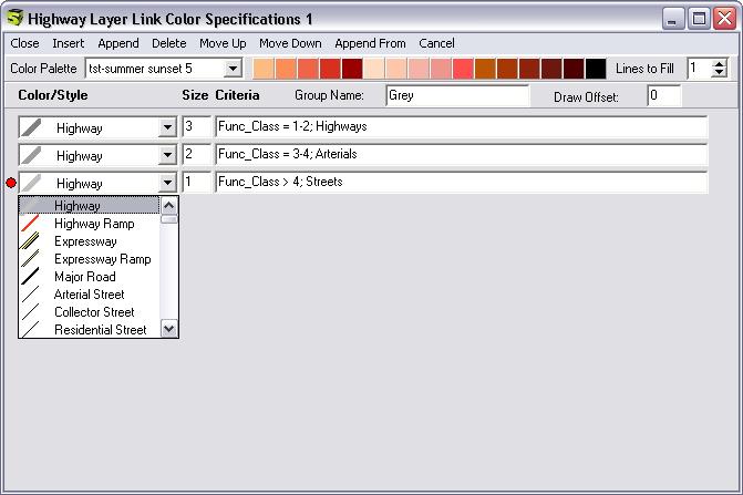
124 Link Color Specifications

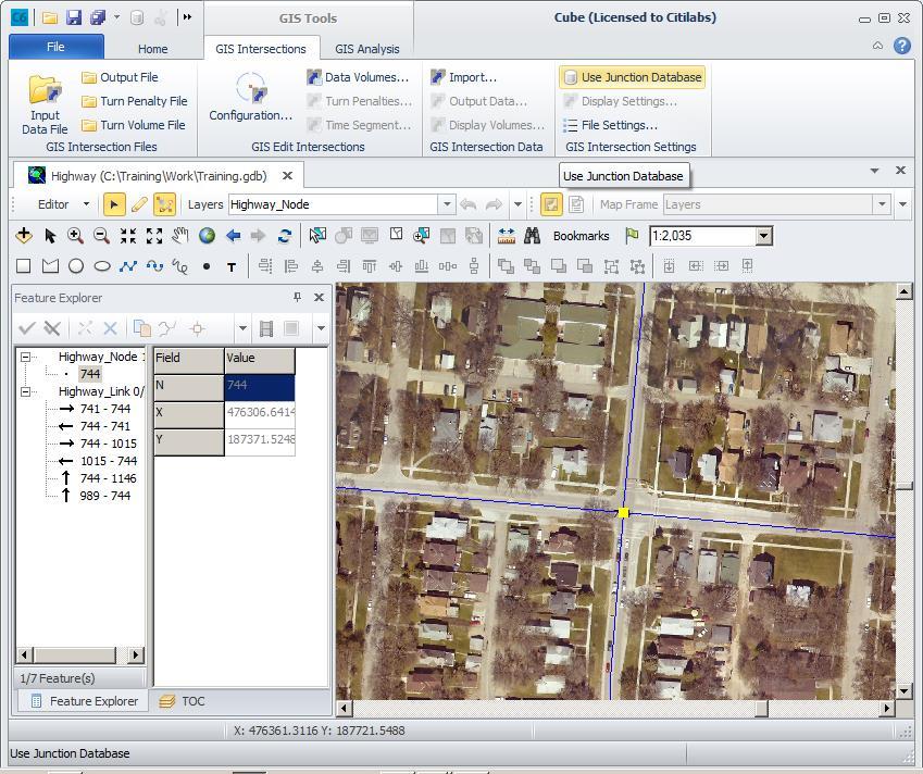
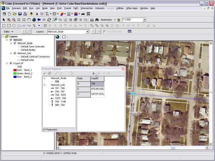
125 GIS Window Options

126 The GIS Window Editing Toolbar GIS Toolbar Data View View Switcher Table of Contents Pointer Coordinates
127 The GIS Toolbar: Navigation Add Data Pan tool Pointer tool Zoom to full extent Rectangular zoom in/out Previous / next extent Fixed zoom in/out Refresh map window
128 The GIS Toolbar: Selection Select Features Pointer Select By Graphics Tool Select Features On Screen Button Clear Selection Button Zoom to Selection Button Select All Button Switch Selection Button


129 The GIS Toolbar: Search Measure Tool Find Tool Bookmarks Menu My Places Button Set Scale Drop-Down
130 The Graphics Toolbar Enabled via Show/Hide Graphics Toolbar under View on Home Ribbon Graphical shapes are non-geographic map elements Similar to Drawing Layer in Cube 4 Network Window Can be used to: Draw graphical shapes Align graphical shapes (layout only) Adjust graphical drawing order & grouping Nudge & rotate graphical shapes


131 The Feature Explorer Feature Explorer: Select By Attributes: Set Selectable Layers:
132 The Editing Toolbar Editor drop-down menu Edit Feature Create Feature Two-Way Editing Active layer drop-down menu Undo/redo buttons


133 The Table of Contents

134 Managing Multiple Layers


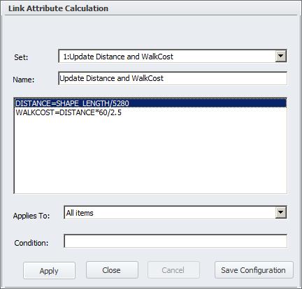
135 Exercise 5: Adding Attributes and Making Attribute Calculations


136 Adding links to the network


137 Copying Link Attributes

138 Editing Link Geometry

139 Area-wide Editing Using a Polygon
140 Representing Intersections Cube provides four ways to represent congestion on the network: In this exercise we will code the intersection information necessary for junction-based capacity restraint


141 Exercise 6: Representing Intersections


142 Representing Intersections (cont d)


143 Representing Intersections (cont d)

144 Representing Intersections (cont d)
145 Representing Intersections (cont d)

146 Representing Intersections (cont d)

147 Exercise 7: Representing Intersections


148 Representing Intersections (cont d)


149 Exercise 8: Copying Data Between GDB Files


150 Select Transit Data for Editing


151 Preparing the View

152 Exercise 9: Create a New Transit Line


153 Coding Line Attributes


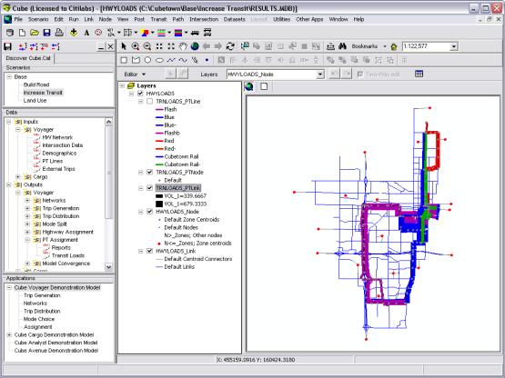
154 Changing Line Display Characteristics


155 Coding Public Transit Systems
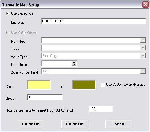
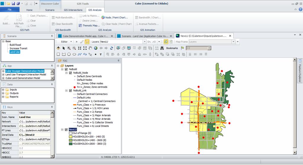
156 MiniQuiz 2 Transportation modeling networks are stored in the following formats in Cube The following are not Public Transit related files in Cube:
157 Lesson 6: Applying Cube Forecasting System 157

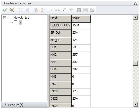
158 Applying Cube Forecasting System


159 Improving Network Quality


160 Editing Link Shape Vertices


161 Run Corrected Base Scenario Using Task Monitor


162 Build Network from Shape Layer (by Cube Base) Build Network from Shapefile
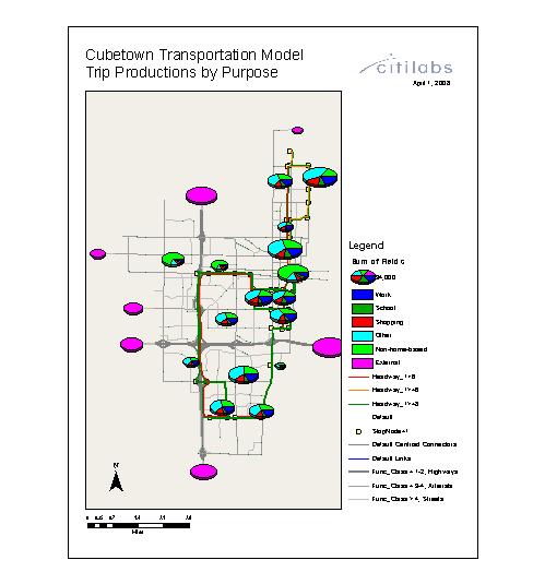
163 Build Network from Shape Layer (by Voyager)
 Ability to consolidate links via")
164 Link Consolidation (by Cube.exe) Ability to consolidate links via script Sample script
165 Lesson 7: Case Studies with Cube 165

166 Case Studies With Cube #1: Building a Road


167 Complete Roadway Segment Using Template Link


168 Review Roadway Scenario Outputs
169 Case Studies With Cube #2: Increase Transit


170 Visualizing Scenario PT Loadings Using Bandwidths
171 Case Studies With Cube #3: Land Use Changes

172 Visualize Current Land Use


173 Modify Land Use Assumptions
174 Creating a Desire Line Display
175 Mapping & Reviewing Data The Layout View Example Maps Saving Settings in the VPR file Sharing maps using MXD files

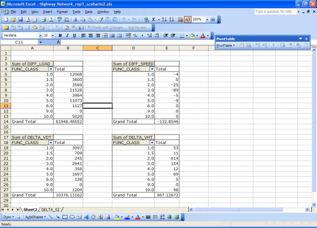
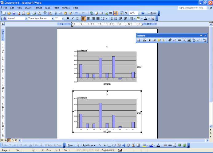
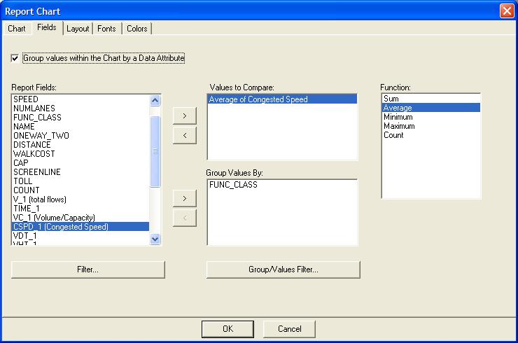
176 The Layout View Layout Navigation Tools Ink Pen Drawing Tools New Data Frame Button Layout Menu Focus Data Frame Control

177 Example Maps
178 Node/Point Chart Maps
179 Intersection LOS Map
180 Link Volume and Speed
181 The roles of VPR and MXD files The Visual Project (VPR) file is still used to track and store settings made in Cube, including: A VPR is created for each MDB, with the same name as the MDB You can import settings from an existing VPR file for another MDB The MXD file is an ArcGIS-compatible map document, containing a snapshot of the current symbol style settings, with no link to VPR Changes stored in the VPR do not affect the MXD and vice versa!


182 Share With GIS Staff

183 Lesson 8: Cube Reports Inputs Outputs 183
184 Cube Reports Overview and motivation A tour of the user interface Creating Reports with the Training Model


185 An overview of Cube Reports


186 An overview of Cube Reports Cube Reports works seamlessly through Cube Base, in order to support modeling from It is an extension which can be used on any size of project, for any type of agency or company Cube Reports can be used to:
187 Create Reports without Cube Reports Consider multiple steps required to generate charts and reports without Cube Reports:

188 Example: standard approach
189 Example: standard approach (cont d) The references among the input files and the final output is lost This process is tedious and error-prone. The process becomes more aggravating when: It takes a long time to
190 Example: standard approach (cont d) It is extremely time consuming The project backup needs to be documented with extreme care


191 Reporting and charting with Cube Reports Cube Reports eliminates errors and cuts reporting time With Cube Reports you use a three step process:
192 Example: Cube Reports approach (cont d) A typical example of the way Cube Reports can be used profitably is to evaluate standard parameters of loaded networks across different scenarios Cube Reports can be used in many different ways, and set up accordingly Depending upon the audience, we can setup different templates


193 Example: Cube Reports approach (cont d)
194 Key advantages of Cube Reports The references among the input files and the final output is automatic This process is simple and the results can be checked immediately The process becomes extremely useful when: It is possible to compare two or more scenarios just by double clicking No need to export/copy/paste multiple databases
195 Lesson 9: Scripting and Text Editing Environment in Cube6 195

196 Window Layout

197 Creating New Script/Text/Print File File > New > Script/Text/Print


198 Opening Script File in Application Manager Click script file Click right-mouse button Choose Text Edit


199 Tab Mode Toggle 1 Click More Buttons Choose Tab Mode Toggle Click Tab Mode Toggle Choose a tab option 2 4 3

200 Settings for Text Editor File > Options > Text/Script
201 Core Editing Functions (1/3)
202 Core Editing Functions (2/3)
203 Core Editing Functions (3/3)
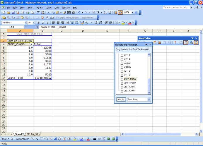
204 Scripting NETWORK Module We will now focus on the Cube NETWORK module as an example of Cube scripting Many of these concepts apply to other Cube Voyager modules Topics to be presented include:
205 Scripting NETWORK Module (cont d) Inputs: Up to 10 Link Files and 10 Nodes Files or 10 Networks Outputs: 1 Network (GDB or Voyager/TP+ NET); Variables: Unlimited Link & Node Example
206 Network program The purpose of the network program is to read data sets supplying link and node information, merge and compute records, and build a network data structure INPUT Node (NI) Link (LI) This is accomplished in multiple phases NODEMERGE Phases process different kinds of data: LINKMERGE SUMMARY

207 Network Program Updated (1/2) Network program is updated Example 1 Sample script file
208 Network Program Updated (2/2) Example 2 Sample script file
209 Scripting of network input and output files FILEI LINKI[#] = NODEI[#] = LOOKUPI[#] = FILEO NETO = LINKO = NODEO = PRINTO[#] =
210 Exercise 10: Output only links with Screenline data Task Inputs: Outputs: Hints:

211 Exercise 10: Solution
212 Exercise 11: Update link attributes Task: Inputs: Outputs: Hints:
213 Exercise 11: Solution


214 Exercise 12: Using Lookup tables Task: Inputs: Outputs: Hints:
215 Exercise 12: Renumber Zones Task: Renumber Zones. Move Zone #26 to Zone#17 Inputs: Outputs: Hints:

216 Exercise 13: Add New Zone and Renumber
217 Exercise 13: Solution
218 Exercise 14: Compare Two Networks Task: Compare two Cube highway networks using script Inputs: Outputs: Hints:

219 Exercise 14: Solution: Compare Two Networks Modify Distance Delete Modify Speed


220 Exercise 15: Compute VMT, VHT, and RMSE Task: Inputs: Outputs: Hints:
221 Exercise 15: Solution
222 Scripting Other Modules In addition to the NETWORK module, other modules for Cube scripting include:
INTRODUCTION TO CUBE
 INTRODUCTION TO CUBE 1 WELCOME TO CUBE... 2 1.1 OVERVIEW... 2 1.2 THE ARCHITECTURE OF CUBE... 3 1.3 THE CUBE USER ENVIRONMENT... 5 1.4 INTEGRATION WITH ARCGIS... 7 1.5 INTEGRATION OF THE CUBE EXTENSIONS...
Southeast Florida FSUTMS Users Group Cube 5.0 Hands-On Training Workshop
 Southeast Florida FSUTMS Users Group Cube 5.0 Hands-On Training Workshop Sponsored by FDOT Central Systems Planning Office, FDOT-D4, & Citilabs Date: Tuesday, July 1, 2008 Time: 10:00 AM Location: FDOT-D4
Discover Cube 6.4 Tutorial
 Discover Cube 6.4 Tutorial Copyright 2007 2016 Citilabs, Inc. All rights reserved. Citilabs is a registered trademark of Citilabs, Inc. All other brand names and product names used in this book are trademarks,
Cube Base. Release Summary. Citilabs
 Cube Base Release Summary Cube Base Release Summary Citilabs Cube Base Release Summary This document describes features introduced in various versions of Cube Base. Sections include: Version 6.4.4 Version
Microsoft. Microsoft. Microsoft Visio Duration: 16hrs
 Visio 2010 Duration: 16hrs Target Audience: This course is designed for users who need to use the diagramming capabilities with Visio 2010. Pre-requisites: Basic knowledge of Windows operating system knowledge
Intro to GIS (requirements: basic Windows computer skills and a flash drive)
") Introduction to GIS Intro to GIS (requirements: basic Windows computer skills and a flash drive) Part 1. What is GIS. 1. System: hardware (computers, devices), software (proprietary or free), people. 2.
Introduction to GIS Intro to GIS (requirements: basic Windows computer skills and a flash drive) Part 1. What is GIS. 1. System: hardware (computers, devices), software (proprietary or free), people. 2.
Explore some of the new functionality in ArcMap 10
 Explore some of the new functionality in ArcMap 10 Scenario In this exercise, imagine you are a GIS analyst working for Old Dominion University. Construction will begin shortly on renovation of the new
for ArcSketch Version 1.1 ArcSketch is a sample extension to ArcGIS. It works with ArcGIS 9.1
 ArcSketch User Guide for ArcSketch Version 1.1 ArcSketch is a sample extension to ArcGIS. It works with ArcGIS 9.1 ArcSketch allows the user to quickly create, or sketch, features in ArcMap using easy-to-use
Answer the following general questions: 1. What happens when you right click on an icon on your desktop? When you left double click on an icon?
 Name: Date: June 27th, 2011 GIS Boot Camps For Educators Practical: Explore ArcGIS 10 Desktop Tools and functionality Day_1 Lecture 1 Sources: o ArcGIS Desktop help o ESRI website o Getting to Know ArcGIS
Name: Date: June 27th, 2011 GIS Boot Camps For Educators Lecture_3
 Name: Date: June 27th, 2011 GIS Boot Camps For Educators Lecture_3 Practical: Creating and Editing Shapefiles Using Straight, AutoComplete and Cut Polygon Tools Use ArcCatalog to copy data files from:
Press the Plus + key to zoom in. Press the Minus - key to zoom out. Scroll the mouse wheel away from you to zoom in; towards you to zoom out.
 Navigate Around the Map Interactive maps provide many choices for displaying information, searching for more details, and moving around the map. Most navigation uses the mouse, but at times you may also
GIS Basics for Urban Studies
 GIS Basics for Urban Studies Date: March 21, 2018 Contacts: Mehdi Aminipouri, Graduate Peer GIS Faciliator, SFU Library (maminipo@sfu.ca) Keshav Mukunda, GIS & Map Librarian Librarian for Geography (kmukunda@sfu.ca)
Exercise 4: Import Tabular GPS Data and Digitizing
 Exercise 4: Import Tabular GPS Data and Digitizing You can create NEW GIS data layers by digitizing on screen with an aerial photograph or other image as a back-drop. You can also digitize using imported
In this exercise, you will convert labels into geodatabase annotation so you can edit the text features.
 Instructions: Use the provided data stored in a USB. For the report: 1. Start a new word document. 2. Follow an exercise step as given below. 3. Describe what you did in that step in the word document
Step by Step GIS. Section 1
 Step by Step GIS Section 1 Contact the web page given below for the data required to do the exercises (http://www.pasda.psu.edu/default.asp) Before beginning the tutorials please visit the Preparation
LAB 1: Introduction to ArcGIS 8
 LAB 1: Introduction to ArcGIS 8 Outline Introduction Purpose Lab Basics o About the Computers o About the software o Additional information Data ArcGIS Applications o Starting ArcGIS o o o Conclusion To
ArcGIS Pro Editing. Jennifer Cadkin & Phil Sanchez
 ArcGIS Pro Editing Jennifer Cadkin & Phil Sanchez ArcGIS Pro Editing Overview Provides tools that allow you to maintain, update, and create new data - Modifying geometry, drawing new features - Entering
4. If you are prompted to enable hardware acceleration to improve performance, click
 Exercise 1a: Creating new points ArcGIS 10 Complexity: Beginner Data Requirement: ArcGIS Tutorial Data Setup About creating new points In this exercise, you will use an aerial photograph to create a new
ArcGIS. for Desktop. Tips and Shortcuts 10.1
 ArcGIS 10.1 for Desktop Tips and Shortcuts Map Navigation Refresh and redraw the display. F5 Suspend the map s drawing. F9 Zoom in and out. Center map. Roll the mouse wheel backward and forward. Hold down
Exercise 1: An Overview of ArcMap and ArcCatalog
 Exercise 1: An Overview of ArcMap and ArcCatalog Introduction: ArcGIS is an integrated collection of GIS software products for building a complete GIS. ArcGIS enables users to deploy GIS functionality
Schematics in ArcMap Tutorial
 Schematics in ArcMap Tutorial Copyright 1995-2010 Esri All rights reserved. Table of Contents Introducing Schematics in ArcMap Tutorial........................ 3 Exercise 1: Getting familiar with Schematics
Making a Sackville Coastal Flood Map
 Making a Sackville Coastal Flood Map Demo covers: Accessing and previewing map templates Modifying map elements such as titles, data frames, legends & scale bars Drawing a graphic on a map Adding text
ArcGIS Pro Editing: An Introduction. Jennifer Cadkin & Phil Sanchez
 ArcGIS Pro Editing: An Introduction Jennifer Cadkin & Phil Sanchez See Us Here WORKSHOP ArcGIS Pro Editing: An Introduction LOCATION SDCC - Ballroom 20 D TIME FRAME Thursday 10:00 11:00 ArcGIS Pro: 3D
Chapter 5. Presenting Data
 Chapter 5. Presenting Data Copyright McGraw-Hill Education. Permission required for reproduction or display. 5-1 Map Design Process 5-2 1 About ArcGIS Chapter 5. Presenting Data 5-3 Page layouts and map
Exercise 1: Getting to know ArcGIS
 The Scenario You are working for the California Visitor s Commission. You have been asked to prepare a map of California for several dignitaries from out of the country. Your map will need to include enough
Review of File Management and Introduction to ArcGIS
 Review of File Management and Introduction to ArcGIS RNR/GEOG 417/517 Overview of Presentation Discuss the objectives of the lab exercise Introduce the class directory structure General file policies Introduce
For more tips on using this workbook, press F1 and click More information about this template.
 Excel: Menu to ribbon reference To view Office 2003 menu and toolbar commands and their Office 2010 equivalents, click a worksheet tab at the bottom of the window. If you don't see the tab you want, right-click
ArcGIS. ArcGIS Desktop. Tips and Shortcuts
 ArcGIS ArcGIS Desktop Tips and Shortcuts Map Navigation Refresh and redraw the display. F5 9.1, Suspend the map s drawing. F9 9.1, Zoom in and out. Center map. Roll the mouse wheel backward and forward.
Manitowoc County, WI Advanced Access GIS Viewer User Documentation
 Manitowoc County, WI Advanced Access GIS Viewer User Documentation Introduction Extensive time was put into developing this website both from a display, and from a printing and scaling perspective. This
ArcMap - EXPLORING THE DATABASE Part I. SPATIAL DATA FORMATS Part II
 Week 5 ArcMap - EXPLORING THE DATABASE Part I SPATIAL DATA FORMATS Part II topics of the week Exploring the Database More on the Table of Contents Exploration tools Identify, Find, Measure, Map tips, Hyperlink,
Tutorial for Lane County Mapping Applications
 Tutorial for Lane County Mapping Applications Contents Overview... 2 Tools... 2 Navigation Tools... 3 Display Tools... 5 Information Tools... 6 Sharing Tools... 7 Common Tasks... 9 Identify or Show Data
Digging Into Autodesk Map 3D 2007 Level 1 Training Rick Ellis Michael Carris Russell Martin
 Digging Into Autodesk Map 3D 2007 Level 1 Training Rick Ellis Michael Carris Russell Martin PO Box 344 Canby Oregon 97013 www.cadapult-software.com training@cadapult-software.com (503) 829-8929 Table of
Exercise 5: Import Tabular GPS Data and Digitizing
 Exercise 5: Import Tabular GPS Data and Digitizing You can create NEW GIS data layers by digitizing on screen with an aerial photograph or other image as a back-drop. You can also digitize using imported
ArcGIS 9. Maplex Tutorial
 ArcGIS 9 Maplex Tutorial Copyright 004 006 ESRI All rights reserved. Printed in the United States of America. The information contained in this document is the exclusive property of ESRI. This work is
Digitizing and Editing Polygons in the STS Gypsy Moth Project. M. Dodd 2/10/04
 Digitizing and Editing Polygons in the STS Gypsy Moth Project M. Dodd 2/10/04 Digitizing and Editing Polygons in the STS Gypsy Moth Project OVERVIEW OF DIGITIZING IN STS 3 THE DIGITIZING WINDOW 4 DIGITIZING
Integrating CAD Data with ArcGIS
 Integrating CAD Data with ArcGIS Agenda An Overview of CAD Drawings CAD Data Structure in ArcGIS Visualization Georeferencing Data Conversion ArcGIS for AutoCAD Q & A CAD Drawings - Overview Widely used
Starting the QGIS Program. Exercise 1: Exploring QGIS
 Exercise 1: Exploring QGIS In this exercise you will learn how to open maps, manipulate layers, add spatial data, change symbols, and navigate within QGIS. You will also learn to repair broken data links.
El Dorado County Travel Demand Model 2012 Update. October 14, FINAL User s Manual. Prepared for: El Dorado County.
 El Dorado County Travel Demand Model 2012 Update October 14, 2013 FINAL User s Manual Prepared for: El Dorado County Prepared by: Copyright 2013, Kimley Horn and Associates, Inc. TABLE OF CONTENTS 1. USER
Streamlining Editing Workflows. Amber Bethell
 Streamlining Editing Workflows Amber Bethell Workflow for solving geographic problems Ask a question Create or acquire data Validate and update data Analyze data Create cartographic product Act upon knowledge
METABUILDER QUICK START GUIDE
 METABUILDER QUICK START GUIDE Table of Contents... 1... 2 The Menu, Tool, Format and Status bar... 2 The Stencil- Properties- Task- and Canvas Pane... 3... 4 Creating, Saving and Loading a model.... 4
Map Library ArcView Version 1 02/20/03 Page 1 of 12. ArcView GIS
 Map Library ArcView Version 1 02/20/03 Page 1 of 12 1. Introduction 1 ArcView GIS ArcView is the most popular desktop GIS analysis and map presentation software package.. With ArcView GIS you can create
Map Preparation. Using QGIS
 Map Preparation Using QGIS Tutorial ID: IGET_GIS_006 This tutorial has been developed by BVIEER as part of the IGET web portal intended to provide easy access to geospatial education. This tutorial is
Exercise Enumeration Areas
 Exercise Enumeration Areas 2007 In this exercise you will work with an existing file geodatabase and create new enumeration areas within the established larger census area maintaining geographic integrity
Data Interoperability Extension Tutorial
 Data Interoperability Extension Tutorial Copyright 1995-2012 Esri All rights reserved. Table of Contents About the Data Interoperability extension tutorial...................... 3 Exercise 1: Using direct-read
Introduction to ArcGIS Desktop
 Introduction to ArcGIS Desktop Prepared by David R. Maidment Center for Research in Water Resources University of Texas at Austin September 2011 Contents Goals of the Exercise Computer and Data Requirements
11.1 Create Speaker Notes Print a Presentation Package a Presentation PowerPoint Tips... 44
 Contents 1 Getting Started... 1 1.1 Presentations... 1 1.2 Microsoft Office Button... 1 1.3 Ribbon... 2 1.4 Mini Toolbar... 2 1.5 Navigation... 3 1.6 Slide Views... 4 2 Customize PowerPoint... 5 2.1 Popular...
3.2 TIPS FOR USING MATLAB
 3.2 TIPS FOR USING MATLAB 3.2.1 Exporting Graphics from MATLAB to WORD and Editing Details Given a graphical plot in MATLAB, say graph.fig, the following procedure allows this graph to be imported into
SilvAssist 3.5 Instruction Manual Instruction Manual for the SilvAssist Toolbar For ArcGIS. Version 3.5
 Instruction Manual for the SilvAssist Toolbar For ArcGIS Version 3.5 1 2 Contents Introduction... 5 Preparing to Use SilvAssist... 6 Polygon Selection... 6 Plot Allocator... 7 Requirements:... 7 Operation...
Microsoft PowerPoint 2007 Tutorial
 Microsoft PowerPoint 2007 Tutorial Prepared By:- Mohammad Murtaza Khan I. T. Expert Sindh Judicial Academy Contents Getting Started... 5 Presentations... 5 Microsoft Office Button... 5 Ribbon... 6 Quick
Undo Button Clicking this tool will undo the last action. Clicking on this tool multiple times will undo all subsequent changes that were made.
 SMS Featured Icons: Editor Window This document includes a brief description of the tools in the SMS Desktop Software Editor windows, as well as showing you the toolbar shortcuts to easily access these
To the GeoView System Overview Online Training Course
 Welcome! To the GeoView System Overview Online Training Course The Alberta Department of Energy provides GeoView as a mapping system to enable users to find geographic information in Alberta. GeoView retrieves
ArcView QuickStart Guide. Contents. The ArcView Screen. Elements of an ArcView Project. Creating an ArcView Project. Adding Themes to Views
 ArcView QuickStart Guide Page 1 ArcView QuickStart Guide Contents The ArcView Screen Elements of an ArcView Project Creating an ArcView Project Adding Themes to Views Zoom and Pan Tools Querying Themes
ArcGIS. ArcGIS Desktop. Tips and Shortcuts
 ArcGIS ArcGIS Desktop Tips and Shortcuts Map Navigation Function Shortcut Availability Refresh and redraw the display. F5 9.1, Suspend the map s drawing. F9 9.1, Zoom in and out. Center map. Roll the mouse
Geographical Information Systems Institute. Center for Geographic Analysis, Harvard University. LAB EXERCISE 1: Basic Mapping in ArcMap
 Harvard University Introduction to ArcMap Geographical Information Systems Institute Center for Geographic Analysis, Harvard University LAB EXERCISE 1: Basic Mapping in ArcMap Individual files (lab instructions,
ArcGIS. Desktop. A Selection of Time-Saving Tips and Shortcuts
 ArcGIS Desktop A Selection of Time-Saving Tips and Shortcuts Map Navigation Refresh and redraw the display F5 9.1, Suspend the map s drawing F9 9.1, Zoom in and out Roll the mouse wheel backward and forward.
THE HONG KONG POLYTECHNIC UNIVERSITY DEPARTMENT OF LAND SURVEYING & GEO-INFORMATICS LSGI521 PRINCIPLES OF GIS
 THE HONG KONG POLYTECHNIC UNIVERSITY DEPARTMENT OF LAND SURVEYING & GEO-INFORMATICS LSGI521 PRINCIPLES OF GIS Student name: Student ID: Table of Content Working with files, folders, various software and
Overview of ArcGIS Online Applications. Champaign County
 Overview of ArcGIS Online Applications Champaign County Champaign County GIS Consortium Updated: April 2017 Table of Contents ArcGIS Online Application Overview... 3 Map Interface Symbology and Terminology...
City of La Crosse Online Mapping Website Help Document
 City of La Crosse Online Mapping Website Help Document This document was created to assist in using the new City of La Crosse online mapping sites. When the website is first opened, a map showing the City
Grapher 10 Ribbon Bar
 Grapher 10 Ribbon Bar When Grapher 10 was released, it included many changes to the user interface. Once such change was the new Ribbon Bar. The Ribbon Bar is designed to better emulate the menu bars in
MAPLOGIC CORPORATION. GIS Software Solutions. Getting Started. With MapLogic Layout Manager
 MAPLOGIC CORPORATION GIS Software Solutions Getting Started With MapLogic Layout Manager Getting Started with MapLogic Layout Manager 2011 MapLogic Corporation All Rights Reserved 330 West Canton Ave.,
Practical Manual. Introduction Geo information Science (GRS 10306) B. Kempen, W.TH. ten Haaf (Ed.)
 B. Kempen, W.TH. ten Haaf (Ed.)") Laboratory of Geographical Information Science and Remote Sensing Centre for Geo Information Introduction Geo information Science (GRS 10306) Practical Manual B. Kempen, W.TH. ten Haaf (Ed.) September
Laboratory of Geographical Information Science and Remote Sensing Centre for Geo Information Introduction Geo information Science (GRS 10306) Practical Manual B. Kempen, W.TH. ten Haaf (Ed.) September
Using ArcGIS 10.x Introductory Guide University of Toronto Mississauga Library Hazel McCallion Academic Learning Centre
 Using ArcGIS 10.x Introductory Guide University of Toronto Mississauga Library Hazel McCallion Academic Learning Centre FURTHER ASSISTANCE If you have questions or need assistance, please contact: Andrew
GIS IN ECOLOGY: CREATING RESEARCH MAPS
 GIS IN ECOLOGY: CREATING RESEARCH MAPS Contents Introduction... 2 Elements of Cartography... 2 Course Data Sources... 3 Tasks... 3 Establishing the Map Document... 3 Laying Out the Map... 5 Exporting Your
The ArcGIS Integration, User Guide. ArcGISv1.01_GEv4.2_UK_User_Guide, 4Ed,pdf.docNumber of pages: 26 Printed:
 The ArcGIS Integration, User Guide ArcGISv1.01_GEv4.2_UK_User_Guide, 4Ed,pdf.docNumber of pages: 26 Printed: 30-04-03 GeoEnviron 4.2 Table of Contents Table of Contents Introduction...3 Development of
دورة تدريبية عن تطبيقات برنامج ARC GIS
 دورة تدريبية عن تطبيقات برنامج ARC GIS مايو 2009 دورة تدريبيت عن تطبيقاث برنامج ARC GIS 2009 مايو Table of Contents Introduction... viii Module 1: Introduction to ArcGIS 9 Module Objectives... 1-1 ArcGIS
Introduction to ArcCatalog
 Introduction to ArcCatalog Introduction To Arc Catalog ArcCatalog is a data- centric GUI tool used for managing spatial data With ArcCatalog you can. Inspect properties and attributes of data Preview and
Getting to Know ModelBuilder
 Getting to Know ModelBuilder Offered by Shane Bradt through the UNH Cooperative Extension Geospatial Technologies Training Center Developed by Sandy Prisloe and Cary Chadwick at the Geospatial Technology
AutoCAD 2009 User InterfaceChapter1:
 AutoCAD 2009 User InterfaceChapter1: Chapter 1 The AutoCAD 2009 interface has been enhanced to make AutoCAD even easier to use, while making as much screen space available as possible. In this chapter,
From Data to Map in 30 Minutes. Aileen Buckley, PhD
 From Data to Map in 30 Minutes Aileen Buckley, PhD This session Crater Lake online map From NPS: https://www.nps.gov/carto/hfc/carto/media/crlamap1.pdf Download Crater Lake map packages here: ArcGIS Pro
Mid-West ESRI Utility User s Group Conference. March 26, 2014
 Mid-West ESRI Utility User s Group Conference March 26, 2014 Presented by: Hillary Bjorstrom, GIS Analyst STAR Energy Services LLC 1 What are Data Driven Pages? Data Driven Pages Workflow Creating an Index
Greenville County Internet Mapping System User s Guide
 Greenville County Internet Mapping System User s Guide Version 2.0 Greenville County Geographic Information Systems May 30, 2006 Table of Contents NAVIGATING TO THE ONLINE MAPPING APPLICATIONS...- 3 -
Display Layers in Geosoft 3D View
 Use the New 2D/3D Workflow features in Target for ArcGIS In Target for ArcGIS version 3.5, there are three new interconnected features that make integrating 2D and 3D data in plan and section maps easier.
Lab 3: Digitizing in ArcMap
 Lab 3: Digitizing in ArcMap What You ll Learn: In this Lab you ll be introduced to basic digitizing techniques using ArcMap. You should read Chapter 4 in the GIS Fundamentals textbook before starting this
Geography 281 Map Making with GIS Project Two: Map Design Issues in ArcMap
 Geography 281 Map Making with GIS Project Two: Map Design Issues in ArcMap This activity provides an introduction to the map design process. It takes you through a typical sequence from the initial decision
Search & Rescue Map Specifications and Production Workflows
 Search & Rescue Map Specifications and Production Workflows About The Search & Rescue map product and production procedures discussed in this document can be utilized to support search, rescue, and relief
TRAINING GUIDE. Mobile for Administrators Part 3 - GIS
 TRAINING GUIDE Mobile for Administrators Part 3 - GIS Mobile for Administrators - GIS One of the critical components of mobile is GIS, and it can also be the most complex. The mobile GIS maps are designed
LAB EXERCISE #1 (25pts)
") Grossmont College Introduction to Geographic Information Science Name: Instructors: Judd Curran & Mark Goodman 1 LAB EXERCISE #1 (25pts) ArcGIS Map Projection on the Fly: Working with: U.S. Map illustrating
Grossmont College Introduction to Geographic Information Science Name: Instructors: Judd Curran & Mark Goodman 1 LAB EXERCISE #1 (25pts) ArcGIS Map Projection on the Fly: Working with: U.S. Map illustrating
Getting Started with VicMap
 Getting Started with VicMap This is a brief overview of some of the tools and features available on VicMap. At any time you can right click on the map and click Identify What s Here to find more information
As a GIS technician, your job will be to take the available data and develop suitability maps for the site.
 Study Guide: Geographic Informations Systems Area: Land-use Analysis with ArcView 3.x Subject: Using Soil maps to Assess site suitability Objectives: Upon completing this study guide you should be able
Roadway Alignments and Profiles
 NOTES Module 15 Roadway Alignments and Profiles In this module, you learn how to create horizontal alignments, surface profiles, layout (design) profiles, and profile views in AutoCAD Civil 3D. This module
TRAINING GUIDE. Tablet: Cradle to Mobile GIS
 TRAINING GUIDE Tablet: Cradle to Mobile GIS Tablet Cradle to Mobile One of the critical components of mobile is the GIS piece, and also can be the most complex. The mobile GIS maps are designed to consume
FactoryLink 7. Version 7.0. Client Builder Reference Manual
 FactoryLink 7 Version 7.0 Client Builder Reference Manual Copyright 2000 United States Data Corporation. All rights reserved. NOTICE: The information contained in this document (and other media provided
To change the shape of a floating toolbar
 Modifying toolbars You can change the size of toolbar buttons and reposition, add, or delete toolbar buttons. You can also change the toolbar name and turn tooltips on and off. An important item to note-
EXCEL 2010 COMPETENCIES
 EXCEL 2010 COMPETENCIES Working with Cells Use undo and redo Clear cell content Enter text, dates, and numbers Edit cell content Go to a specific cell Insert and delete selected cells Cut, copy, paste,
FULL MOTION VIDEO TUTORIAL
 FULL MOTION VIDEO TUTORIAL AUGUST 2016 TABLE OF CONTENTS Table of Contents Overview 1 Description of the Exercises 1 Overview of the Video Player: Exercise 1 3 Open ArcMap and the FMV Add-In 3 Play an
Introduction to Geodatabase and Spatial Management in ArcGIS. Craig Gillgrass Esri
 Introduction to Geodatabase and Spatial Management in ArcGIS Craig Gillgrass Esri Session Path The Geodatabase - What is it? - Why use it? - What types are there? - What can I do with it? Query Layers
ArcGIS Basics Working with Labels and Annotation
 ArcGIS Basics Working with Labels and Annotation Labeling in ArcGIS has changed considerably from the old ArcView 3.X version. In ArcGIS label positions are generated automatically, are not selectable,
ArcGIS Server: publishing geospatial data to the web using the EEA infrastructure
 ArcGIS Server: publishing geospatial data to the web using the EEA infrastructure *IMPORTANT: Map Services should be published using the EEA Map Services Tick Sheet for guidance. Contact Sebastien Petit
Measuring Area/Length of Organisms with GIS
 Measuring Area/Length of Organisms with GIS These instructions enable you to measure the length and area of microscopic organisms in ArcGIS from digital photographs. The four-step process involves: georeferencing
HEC-RAS 5.0 Training New Zealand Workshop Guide
 HEC-RAS 5.0 Training New Zealand Workshop Guide Prepared by: Krey Price Surface Water Solutions 57 Bromfield Drive Kelmscott WA 6111 Australia Tel. +61 400 367 542 e-mail: info@surfacewater.biz website:
Getting Started with MapInfo Professional Hands On Session 1D
 In this session, the following topics will be covered: Open a DBF file Create Points Geocode to 5 digit ZIPCodes Use Query > Select Use the Select Tools Create a Thematic Map The Layout Window MapWorld
GPS TO GIS EXERCISE (30 PTS)
") GPS TO GIS EXERCISE (30 PTS) This exercise will allow you to demonstrate your cumulative knowledge of using a GPS receiver to collect data with locational information, downloading this data to a desktop
GPS TO GIS EXERCISE (30 PTS) This exercise will allow you to demonstrate your cumulative knowledge of using a GPS receiver to collect data with locational information, downloading this data to a desktop
ArcGIS Drivers Permit. Using ESRI ArcView 10 and NH GRANIT Data
 ArcGIS Drivers Permit Using ESRI ArcView 10 and NH GRANIT Data UNH Cooperative Extension September 2011 Original Draft: September 2011 Exercise manual by: Anne Deely University of New Hampshire Cooperative
Chapter 7. A Quick Tour of ArcGIS Pro
 Chapter 7 A Quick Tour of ArcGIS Pro Skills you will learn: This tutorial is intended to get you going using ArcGIS Pro, a new desktop application that is part of ArcGIS Desktop. A separate tutorial gives
ArcGIS 9. Using ArcReader
 ArcGIS 9 Using ArcReader Copyright 2003 2004 ESRI. All Rights Reserved. Printed in the United States of America. The information contained in this document is the exclusive property of ESRI. This work
MapInfo Pro. Version 17 Overview
 MapInfo Pro tm Version 17 Overview 1 Disclaimers & Notes Most of what you ll see is a Work in Progress There will be some bugs and incomplete functionality Some things being shown are not yet available
Software Introduction
 Software Introduction B Software Introduction Design Era Universal V11.21 November 2011 Table of Contents Welcome to Stitch/Design Era Universal software.... 1 Basic User Interface... 1 Application button
ArcCatalog or the ArcCatalog tab in ArcMap ArcCatalog or the ArcCatalog tab in ArcMap ArcCatalog or the ArcCatalog tab in ArcMap
 ArcGIS Procedures NUMBER OPERATION APPLICATION: TOOLBAR 1 Import interchange file to coverage 2 Create a new 3 Create a new feature dataset 4 Import Rasters into a 5 Import tables into a PROCEDURE Coverage
Editing Parcel Fabrics Tutorial
 Editing Parcel Fabrics Tutorial Copyright 1995-2010 Esri All rights reserved. Table of Contents Tutorial: Getting started with parcel fabric editing...................... 3 Tutorial: Creating new parcels
Developers Road Map to ArcGIS Desktop and ArcGIS Engine
 Developers Road Map to ArcGIS Desktop and ArcGIS Engine Core ArcObjects Desktop Team ESRI Developer Summit 2008 1 Agenda Dev Summit ArcGIS Developer Opportunities Desktop 9.3 SDK Engine 9.3 SDK Explorer