Deploying ArcGIS at an Electric Utility. Previn Wong Patrick Demer Patrick Dolan
|
|
|
- Oswin Willis
- 5 years ago
- Views:
Transcription


1 Deploying ArcGIS at an Electric Utility Previn Wong Patrick Demer Patrick Dolan
2 Deploying ArcGIS at a Electric Utility Start from scratch Start with a data model Start with business problem - Use Solutions as a jumpstart
3 Deploying ArcGIS at a Electric Utility Start from scratch Start with a data model Start with business problem - Use Solutions as a jumpstart - To the Field - In the Office - To the Customer
4 ArcGIS Includes Ready-to-Use Maps and Apps
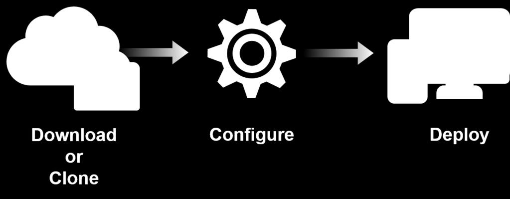
5 Deployment Pattern Download or Clone Configure Deploy

6 Deploying ArcGIS for Electric
7 Deploying ArcGIS for Electric 1. Configure Your Mapping Portal 2. Configure Initial Apps 3. Continue to Innovate
8 Configure your Portal


9 Configure your Portal Brand


10 Configure your Portal Organize


11 Configure your Portal Content
 Your Mapping")
12 Deployment - Recap Electric Model Org Portal (Brand / Organize / Content) Your Mapping Portal


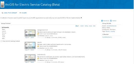
13 Configure your Portal To learn more Electric Facility Maps Model Org ArcFM Feeder Map
14 Configure Initial Apps
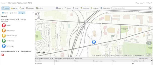
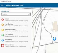
15 Configure Your Initial Set of Apps To the Field Business Challenge - Support Contractors / Foreign Crews - Short timeline - Data validation Damage Assessment
16 Deployment - Recap Service Catalog Portal Collector Data Reviewer


17 Configure Your Initial Set of Apps To learn more Damage Assessment Collector Data Reviewer for Electric
18 Configure Your Initial Set of Apps To the Office Business Challenge - Assess vulnerability of infrastructure - Access authoritative data - Share analysis to the organization Storm Vulnerability
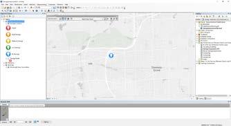
19 Storm Vulnerability Analysis Storm Vulnerability Assessment Geoprocessing Model

 Share")
20 Deployment - Recap ArcGIS Pro Project Project (Geoprocessing Model / Tasks) Share Project

21 Configure Your Initial Set of Apps To learn more Storm Vulnerability Assessment Infrastructure Vulnerability - Beta in August
22 Configure Your Initial Set of Apps To the Customer Business Challenge - Sharing Outage Information - Provide feedback - Communicate additional services Outage Center


23 Across Utilities, Service Outage /Storm Response is on the Rise


24 Storm or Outage Centers (One Stops) are on the Rise
25 Deployment - Recap


26 Configure your Initial Set of Apps To learn more Public Outage Map Report Streetlight Problem
27 Innovate
28 Modernize Your Apps Flex Viewer Final release November 2014 The latest release of ArcGIS API for Flex is significant in that it is the last planned release of this technology. While technical support will be available through June of 2016, maintenance will be discontinued. Silverlight Viewer Final release January marks the last planned releases of the ArcGIS API for Silverlight and ArcGIS Viewer for Silverlight. Technical support for both products will continue to be available through June of 2016.
29 Ways to Modernize Providing Easy, Configurable, and Extensible Tools Configurable Templates Web AppBuilder Widgets HTML5/JavaScript Design Once, Run Everywhere...

30 Configurable Templates Decrease Development Time 35 Templates Crowdsource Suite Simple Scene Viewer Map Gallery Story Maps Local Perspective Map Tour Photo Survey Simple Viewer Impact Summary GeoForm Information Lookup

31 Web AppBuilder Deploy your focused app, your way.

32 Widgets WAB FLEX WAB 7 new core widgets Released In June 9 widgets in Solutions for local deployment

33 GeoNet Web AppBuilder Community 20+ widgets in the community.

34 Summary Deploying ArcGIS at an Electric Utility 1. Configure Your Mapping Portal 2. Configure Initial Apps 3. Continue to Innovate

35 ArcFM Templates
36 Remember: Dates, names, products, functionality and backlog items will change.
37 ArcGIS for Electric Roadmap February June Late Summer Fall Early Winter Enhanced ArcGIS Model Organization Damage Collection Dashboard Pole Reports New Group Filter Widget Smart Editor Widget Utility Network ArcFM Feeder Map Infrastructure Vulnerability Assessment Data Reviewer
38 ArcGIS for Electric Roadmap Utility Network Base industry data models Data loading scripts for the Utility Network Configuring the Maps and Apps on the Utility Network Electric network Transmission network Distribution network Structural network Gas networks Gas network Structural network Cathodic protection network

39 Staying Connected Need Help for Ready-to-Use Maps & Apps? Supporting Links and Resources Contact Esri Support Participate in the user community - GeoNet - Esri Events Configuration Assistance - Esri Business Partners

40 Questions?
Web AppBuilder Presented by
 Web AppBuilder Presented by Agenda Product overview Web AppBuilder for ArcGIS tour What s new in the ArcGIS Online June 2016 update Customization Community and Resources Summary The ArcGIS Platform enables
Web App Builder: Code-free Development. Adam Ziegler, Esri-Northeast, Local Government Team
 Web App Builder: Code-free Development Adam Ziegler, aziegler@esri.com Esri-Northeast, Local Government Team Agenda Product overview Web AppBuilder for ArcGIS tour Adding Custom Widgets Community and Resources
Introduction to Web AppBuilder for ArcGIS: JavaScript Apps Made Easy
 Introduction to Web AppBuilder for ArcGIS: JavaScript Apps Made Easy Jianxia Song & Derek Law July 21, 2015 Agenda Product overview Web AppBuilder for ArcGIS tour What s New July 2015 ArcGIS Online update
Web AppBuilder for ArcGIS: JavaScript Apps Made Easy
 Web AppBuilder for ArcGIS: JavaScript Apps Made Easy Ryan Sellman @rcsellman Agenda Product overview Web AppBuilder for ArcGIS tour Customization Community and Resources Summary The ArcGIS Platform enables
Creating Apps Using ArcGIS Online Templates. Matt Kennedy
 Creating Apps Using ArcGIS Online Templates Matt Kennedy Topics we will cover The publishing process Before you publish Where apps live Breakdown of apps Publishing web app templates The steps for publishing
ArcGIS App Strategies Ben
 ArcGIS App Strategies Ben Ramseth Bramseth@esri.com @esrimapninja DevSummit DC February 26, 2016 Washington, DC Session overview Topics Understanding ArcGIS s Defining strategies for building s Applying
Introducing Survey123 For ArcGIS
 FedGIS Conference February 24 25, 2016 Washington, DC Introducing Survey123 For ArcGIS James Tedrick, Esri Jawameer Kakakhan, UN OCHA Configurable Solutions That Work Together Vizualize Collect Navigator
Geo Apps: Modern Day GIS
 Geo Apps: Modern Day GIS Exercise 1: Create a customer service request app Estimated time: 20 minutes Exercise 2: Create a story map Estimated time: 30 minutes Exercise 3: Use Web AppBuilder for ArcGIS
Expand Your Audience through ArcGIS Online Workshop 2018 IMAGIN Conference
 Workshop 2018 IMAGIN Conference Park Place Hotel and Conference Center June 19, 2018 Welcome Introductions Logistics Bathrooms Schedule (10 am-1 pm) What is ArcGIS Online? Organizational Settings Break
Survey123 for ArcGIS: An Introduction. James Tedrick Erin Densford
 Survey123 for ArcGIS: An Introduction James Tedrick Erin Densford Smart Forms for ArcGIS Easily convert paper forms into Digital Smart ArcGIS Forms Why Smart Forms in ArcGIS? Reduce Errors During Data
Advances in GIS help create Smarter Communities
 Advances in GIS help create Smarter Communities POP(ovich) Quiz Who is a Desktop User? Who is an ArcGIS Online User? Who is a ArcGIS Server Admin? Who is a Programmer? Who works with or for a government
Insight into the Utility Network. Erik Hoel and Tom Brown March 13, 2018
 Insight into the Utility Network Erik Hoel and Tom Brown March 13, 2018 Utility network New network framework to support utility and telco solutions Vision: Provide utility customers with the ability to
An Introduction to GIS for developers
 An Introduction to GIS for developers Part 4: GIS Sharing Canserina Kurnia & Tom Shippee Agenda Web GIS ArcGIS Online Cloud-based ArcGIS Server ArcGIS Server on-premises ArcGIS a complete platform discover,
OpenSpirit Enabled GIS Portal Apps. Todd Buehlman, LOGIC Solutions Group Clay Harter, TIBCO September 7, 2016
 OpenSpirit Enabled GIS Portal Apps Todd Buehlman, LOGIC Solutions Group Clay Harter, TIBCO September 7, 2016 LOGIC Solutions Group Working to create, manage and integrate your information management and
Sharing Web Layers and Services in the ArcGIS Platform. Melanie Summers and Ty Fitzpatrick
 Sharing Web Layers and Services in the Platform Melanie Summers and Ty Fitzpatrick Agenda Platform overview - Web GIS information model - Two deployment options Pro Sharing - User experience and workflows
Leveraging Esri Web AppBuilder s Free Widgets in Your Web GIS
 Leveraging Esri Web AppBuilder s Free Widgets in Your Web GIS Dan Loegel, GISP Implementation Specialist GeoNexus Technologies June 18, 2018 Agenda 1. What is Web AppBuilder 2. The Basics 3. Widgets 4.
USING WEB APPBUILDER TO TRACK TEMPORARY WATER METER DEPLOYMENTS. Olivia DeSimone, GISP GIS Analyst City of Altamonte Springs
 USING WEB APPBUILDER TO TRACK TEMPORARY WATER METER DEPLOYMENTS Olivia DeSimone, GISP GIS Analyst City of Altamonte Springs CITY OF ALTAMONTE SPRINGS Located in Seminole County (Central Florida) Seminole
Enabling High-Quality Printing in Web Applications. Tanu Hoque & Craig Williams
 Enabling High-Quality Printing in Web Applications Tanu Hoque & Craig Williams New Modern Print Service with ArcGIS Enterprise 10.6 Quality Improvements: Support for true color level transparency PDF produced
ArcGIS for Server: What s New. Philip Heede, Jay Theodore
 ArcGIS for Server: What s New Philip Heede, Jay Theodore Agenda GIS server Web GIS: Portal for ArcGIS ArcGIS for Server Extensions - GeoEvent Extension - Production Mapping Primary target for new functionality
Nick Tonias, P.E. The CEDRA Corporation. Ian Peebles, GISP The City of Edmond
 Nick Tonias, P.E. The CEDRA Corporation Ian Peebles, GISP The City of Edmond u u u u u u Brief Intro to CEDRA and City of Edmond Creating Apps using ArcGIS Online Creating Apps using ArcGIS Serer Presentation
Collector for ArcGIS. Paul Barker and Russ Roberts
 Collector for ArcGIS Paul Barker and Russ Roberts Agenda A quick look at the mobile landscape ArcGIS the platform Looking at the problem What is Collector for ArcGIS Demo Quick tips What s next? Questions
ArcGIS Enterprise: Architecture & Deployment. Anthony Myers
 ArcGIS Enterprise: Architecture & Deployment Anthony Myers 1 2 3 4 5 Web GIS Overview of ArcGIS Enterprise Federation & Hosted Server Deployment Patterns Implementation 1 Web GIS ArcGIS Enabling GIS for
Does Your Data Have Harmony. Dan Stone
 Does Your Data Have Harmony Dan Stone Agenda Introduction Configuration Patterns Implementation Approaches Your Feedback ArcGIS for Local Government Esri solutions for local government customers Series
Citizen Reporter App for DuPage County. Illinois GIS Association Annual Conference Ryan Nosek, GIS Analyst, DuPage County October 18 th, 2016
 Citizen Reporter App for DuPage County Illinois GIS Association Annual Conference Ryan Nosek, GIS Analyst, DuPage County October 18 th, 2016 Presentation Topics Crowdsourcing Apps from Esri Crowdsource
No Programming Required Create web apps rapidly with Web AppBuilder for ArcGIS
 No Programming Required Create web apps rapidly with Web AppBuilder for ArcGIS By Derek Law, Esri Product Manager, ArcGIS for Server Do you want to build web mapping applications you can run on desktop,
Road Ahead for Network Management. Larry Young Esri Product Management
 Road Ahead for Network Management Larry Young Esri Product Management Network Management Session Presentation Agenda - Overview - Why you want a Utility Network? - What exactly is a Utility Network? -
Enabling High-Quality Printing in Web Applications. Tanu Hoque & Jeff Moulds
 Enabling High-Quality Printing in Web Applications Tanu Hoque & Jeff Moulds Print Service Technical Session Outline What s new in 10.6x What is Print Service Out of the box print solutions Print service
3D in the ArcGIS Platform. Chris Andrews
 3D in the ArcGIS Platform Chris Andrews Geospatial 3D is already all around us 3D is expanding the GIS community s opportunity to provide value 3D City & Infrastructure Models Generated 3D features Photogrammetrc
KENYA 2019 Training Schedule
 KENYA 2019 Training Schedule Monday Tuesday Wednesday Thursday Friday 4th Feb 5th Feb 6th Feb 7th Feb 8th Feb Using 11th Feb 12th Feb 13th Feb 14th Feb 15th Feb Using (cont...) Field Data Collection and
Managing Utility and Telco Networks
 Managing Utility and Telco Networks with ArcGIS Tom Brown, Rick Anderson, and Larry Young Network Management Session Presentation Agenda - Overview - Why you want a Utility Network? - What exactly is a
What s New in ArcGIS 10.4 for Server
 What s New in ArcGIS 10.4 for Server Derek Law, Esri Jan 19, 2016 Esri Southwest User Conference Agenda Product story GIS Server Sharing content from ArcGIS Pro Portal for ArcGIS Client Apps Summary Strongly
ArcGIS GeoEvent Server: Making 3D Scenes Come Alive with Real-Time Data
 ArcGIS GeoEvent Server: Making 3D Scenes Come Alive with Real-Time Data Morakot Pilouk, Ph.D. Senior Software Developer, Esri mpilouk@esri.com @mpesri Agenda 1 2 3 4 5 6 3D for ArcGIS Real-Time GIS Static
3D in the Browser with WebGL. Chris Andrews 3D Product Manager Javier Gutierrez 3D Product Engineer
 3D in the Browser with WebGL Chris Andrews 3D Product Manager Javier Gutierrez 3D Product Engineer Just sayin This is not a programming class Goal is to help you learn about a technology area that impacts
ArcGIS for Mobile Devices: An Overview. Jeff Shaner Bonnie Stayer
 ArcGIS for Mobile Devices: An Overview Jeff Shaner Bonnie Stayer Agenda Esri Positioning and Key Benefits Your Mobility Strategy Q & A Positioning and Benefits Key Benefits of Mobile Solutions Leverage
Leveraging metadata standards in ArcGIS to support Interoperability. Aleta Vienneau and Marten Hogeweg
 Leveraging metadata standards in ArcGIS to support Interoperability Aleta Vienneau and Marten Hogeweg Leveraging metadata standards in ArcGIS to support Interoperability Overview of metadata standards
Working with the ArcGIS Viewer for Flex Application Builder
 Working with the ArcGIS Viewer for Flex Application Builder Esri Canada User Conference St. John s November 15, 2012 Presented By: Greg Yetman gyetman@esri.ca Agenda This seminar is designed to help you
ArcGIS for Developers: An Introduction. Moey Min Ken
 ArcGIS for Developers: An Introduction Moey Min Ken AGENDA Is development right for me? Building Apps on the ArcGIS platform Rest API & Web API Native SDKs Configurable Apps and Builders Extending the
ArcGIS Solutions for Community Resilience. Matthew S Deal
 ArcGIS Solutions for Community Resilience Matthew S Deal Solutions Overview Leverage hundreds of ready-to-use maps, apps, and platform configurations to meet your needs, delivering innovation and best
Configuring ArcGIS Enterprise in Disconnected Environments
 Configuring ArcGIS Enterprise in Disconnected Environments BILL MAJOR Disconnected Environments Not everyone has internet access? How many of you run disconnected today, i.e. no internet access? Many customers
Working with Feature Layers. Russell Brennan Gary MacDougall
 Working with Feature Layers Russell Brennan Gary MacDougall Working with Feature Layers Session will focus on feature access and editing Highlight new features added over the last few releases Agenda Introduction
ArcGIS Online: Managing Data. Jeremy Bartley Sentha Sivabalan
 ArcGIS Online: Managing Data Jeremy Bartley (jbartley@esri.com) Sentha Sivabalan (ssivabalan@esri.com) Agenda Creating and managing content like Apps, Maps, Scenes and Layers in ArcGIS Today s Topics:
USERS CONFERENCE Copyright 2016 OSIsoft, LLC
 Conference Theme and Keywords 2 PI Integrator for Esri ArcGIS Sparkling Maps are just the beginning Presented by Michelle Kuiee, OSIsoft Two companies One Vision We believe data in the hands of smart people
Streetlight Management Plan Advisory Panel Meeting. January 4, 2017
 Streetlight Management Plan Advisory Panel Meeting January 4, 2017 Agenda Introduction Advisory Panel Role Streetlight Management Plan and the Development Process Arlington s LED Streetlight Program Panel
Creating Geoprocessing Services and Web Tools. Darren Baird, PE, Esri
 Creating Geoprocessing Services and Web Tools Darren Baird, PE, Esri Introduction Both ArcMap and ArcGIS Pro are covered Terms Geoprocessing Services and Web Tools are the same - ArcMap publishes geoprocessing
Creating Web Mapping Applications. Nikki Golding
 Creating Web Mapping Applications Nikki Golding Agenda Web Mapping and Map Services Fundamentals ArcGIS Web Mapping Applications - ArcGIS.com Viewer - ArcGIS Explorer Online - ArcGIS Viewer for Flex -
What s New in ArcGIS 10.3 for Server. Tom Shippee Esri Training Services
 What s New in ArcGIS 10.3 for Server Tom Shippee Esri Training Services Today s Agenda What is ArcGIS for Server at 10.3 - ArcGIS Platform story - Expanding ArcGIS for Server paradigm What s new in ArcGIS
ArcGIS Web Viewers and Templates. Andy Gup, Jim Barry
 ArcGIS Web Viewers and Templates Andy Gup, Jim Barry What s new in the ArcGIS Viewer for Flex Andy Gup, Jim Barry ArcGIS Viewer for Flex ArcGIS API for Flex ArcGIS Online / Portal / Orgs ArcGIS Server
ICIT. Brian Hiller ESRI Account Manger. What s new in ArcGIS 10
 ICIT Brian Hiller ESRI Account Manger What s new in ArcGIS 10 ArcGIS 10 Fast Easy Powerful Everywhere late June 2010 ArcGIS System for Geographic Information Desktop Server Mobile Online A System A Complete
ArcGIS Data Reviewer: Ensuring Accurate and Complete Data to Meet Your Mission. John Grammer Kevin Pusey
 ArcGIS Data Reviewer: Ensuring Accurate and Complete Data to Meet Your Mission John Grammer Kevin Pusey Workshop agenda Defining data quality What is ArcGIS Data Reviewer? Automated review Semi-automated
Open File Explorer Start Pro with SanFran project Open Locator in SanFran project Open Browser and AGOL with RouteExample Web map.
 Open File Explorer Start Pro with SanFran project Open Locator in SanFran project Open Browser and AGOL with RouteExample Web map. Open Browser with this: http://nadev.arcgis.com/arcgis/samples/easyvrp/easyvrp.html
ArcGIS GeoEvent Server: Leveraging Stream Services. Ken Gorton RJ Sunderman
 ArcGIS GeoEvent Server: Leveraging Stream Services Ken Gorton RJ Sunderman Agenda 1 2 3 4 5 Overview of Stream Services & Stream Layers Publishing Stream Services Visualization of real-time data Sample
The age of location enlightenment
 The age of location enlightenment GIS in Public Safety. More than a map Chris McIntosh cmcintosh@esri.com Presentation Topics Patterns in Successful Deployments Requirements How GIS is Changing Examples
Developing Cross-Platform Native Apps with AppStudio for ArcGIS. Jo Fraley Erwin Soekianto
 Developing Cross-Platform Native Apps with AppStudio for ArcGIS Jo Fraley Erwin Soekianto AppStudio for ArcGIS ios Android Linux 1App Windows Mac What is AppStudio for ArcGIS? A suite of productivity tools
TRAINING GUIDE. Lucity GIS. Web Administration
 TRAINING GUIDE Lucity GIS Web Administration Lucity GIS Web Administration Contents Portal Config and SSO... 2 Registering with Portal... 2 Behind the Scenes... 4 Resetting Portal Integration... 5 Single
Customizing Web AppBuilder using Third Party Products. Presented to: Esri Canada Toronto UC Presented by: Maura Daffern October 11 th, 2018
 Customizing Web AppBuilder using Third Party Products Presented to: Esri Canada Toronto UC Presented by: Maura Daffern October 11 th, 2018 Introduction Third Party Products? Who Am I? Agenda What is the
ArcGIS Apps for the Mobile Worker. Presented by: Sue Enyedy-Goldner
 ArcGIS Apps for the Mobile Worker Presented by: Sue Enyedy-Goldner Agenda 1. Overview of ArcGIS apps for mobile workflows 2. Considerations for configuring the best app for your workflow 3. Configuration
Collector for ArcGIS
 Collector for ArcGIS Field GIS Taking GIS Beyond the Office Collecting Data Reporting Observations Managing Work Connecting the Field with the Enterprise Field Mobility Solutions Improve accuracy and currency
Configuring the ArcGIS for Local Government Solution
 Configuring the ArcGIS for Local Government Solution Lindsay Thomas Steve Grise Scott Oppmann Esri UC 2015 Technical Workshop Agenda Introduction Configuration Patterns Implementation Approaches Your Feedback
ArcGIS Apps for the Mobile Worker. Presented by: Sue Enyedy-Goldner
 ArcGIS Apps for the Mobile Worker Presented by: Sue Enyedy-Goldner Agenda 1. Overview of ArcGIS apps for mobile workflows 2. Considerations for configuring the best app for your workflow 3. Configuration
Interactive webmaps with ArcGIS. Kristel Meikas, AlphaGIS
 Interactive webmaps with ArcGIS Kristel Meikas, AlphaGIS Agenda Overview of ArcGIS tools and resources Introduction to ArcGIS APIs In depth with Flex maps In depth with JavaScript maps ArcGIS Server Publish
Introduction to Your First ArcGIS Enterprise Deployment. Thomas Edghill & Jonathan Quinn
 Introduction to Your First ArcGIS Enterprise Deployment Thomas Edghill & Jonathan Quinn Overview Web GIS options with Esri Building a Base ArcGIS Enterprise Deployment - Overview of Base ArcGIS Enterprise
What is new in ArcGIS 10.2.x for Server
 What is new in ArcGIS 10.2.x for Server Ismael Chivite, Greg Tieman Esri UC 2014 Technical Workshop Map cache status Windows and Linux friendly Simplified architecture 64 bit Performance Improvements Administration
ArcGIS Online. The Road Ahead Geoff Mortson
 ArcGIS Online The Road Ahead Geoff Mortson gmortson@esricanada.com ArcGIS Online Easily create and share maps Delivered as intelligent maps Access on virtually any device anyone, anywhere Compliments and
ArcGIS Pro: Effective License Management. Stephanie Wendel Melanie Summers Rob Elkins
 ArcGIS Pro: Effective License Management Stephanie Wendel Melanie Summers Rob Elkins Effective License Management Licensing Model Key Concepts Setting Up and Managing your Organization Grouping Users How
Using Collector for ArcGIS and Operations Dashboard for ArcGIS. Mike Sweeney Esri-Charlotte
 Using Collector for ArcGIS and Operations Dashboard for ArcGIS Mike Sweeney Esri-Charlotte Agenda The ArcGIS Platform Desktop Web Device Portal Cloud Server Online Content and Services On-Premises Available
Web Mapping Applications with ArcGIS. Bernie Szukalski Derek Law
 Web Mapping Applications with ArcGIS Bernie Szukalski Derek Law Agenda Web Mapping and Map Services Fundamentals ArcGIS Web Mapping Applications - Hosted online - Hosted on-premise Summary Web Application
ArcGIS Enterprise: Configuring Backups, Disaster Recovery, and Replication. Harrold Sompotan and Patrick Jackson
 ArcGIS Enterprise: Configuring Backups, Disaster Recovery, and Replication Harrold Sompotan and Patrick Jackson Agenda Brief History of WebGIS DR Tool Who, Why, What, When, How and Where Considerations
ArcGIS Enterprise: Architecting Your Deployment
 ArcGIS Enterprise: Architecting Your Deployment ArcGIS Enterprise ESRI USER CONFERENCE 2017 1 Assumptions and Prerequisites This document assumes you are a system architect or an IT administrator (or work
COMED S CATASTROPHIC STORM PLANS
 COMED S CATASTROPHIC STORM PLANS MEA Electric Operations Conference May 13, 2015 Kimberly A. Smith Director, Emergency Preparedness, Distribution System Operations MEET THE EXELON UTILITIES 2 Chicago,
Navigator for ArcGIS Presented by
 Navigator for ArcGIS Presented by Navigator for ArcGIS Get your field workforce where it needs to be Custom data (search, route, display) Fully integrated with other apps Advanced vehicle travel modes
Application of GIS to Cybersecurity. Brian Biesecker Ken Mitchell
 Application of GIS to Cybersecurity Brian Biesecker Ken Mitchell Fundamental Problems that GIS can help you solve What are the impacts to your mission, operations, business activities, critical systems,
GIS-T 2016 PennDOT s Path to Survey123 for Field Collection
 GIS-T 2016 PennDOT s Path to Survey123 for Field Collection Jeff Fennimore, Spatial Infrastructure Manager Pennsylvania DOT Nate Reck, Gov t Solutions Director GeoDecisions Topics/Discussions Asset Condition
Architecting the ArcGIS Platform: Best Practices. Raymond Bunn, GISP, PMP Esri Patterns & Practices Solution Architect
 Architecting the ArcGIS Platform: Best Practices Raymond Bunn, GISP, PMP Esri Patterns & Practices Solution Architect E M E R A L D S A P P H I R E T H A N K Y O U T O O UR SPONSORS Please Take Our Survey
Understanding and Using Metadata in ArcGIS. Adam Martin Marten Hogeweg Aleta Vienneau
 Understanding and Using Metadata in ArcGIS Adam Martin Marten Hogeweg Aleta Vienneau Adam Martin National Government Account Management R&D Open Data Marten Hogeweg National Government Professional Services
ESRI Technology Update. Joe Holubar Larry Young
 ESRI Technology Update Joe Holubar Larry Young Continued Improvement Improving Quality and Extending and Refining Functionality First Half of 2009: Minor Update Release (ArcGIS 9.3.1) ArcGIS Explorer Fall
ImageNow Interact for Esri ArcGIS Server for Silverlight Getting Started Guide
 ImageNow Interact for Esri ArcGIS Server for Silverlight Getting Started Guide Esri Silverlight Viewer Tools ImageNow Version: 6.6.x Written by: Product Documentation, R&D Date: January 2013 ImageNow and
Florida Power & Light Company Hurricane Response Update. Eric Silagy President and CEO Florida Power & Light Company
 Florida Power & Light Company Hurricane Response Update Eric Silagy President and CEO Florida Power & Light Company 35 counties Serving more than half of Florida 4.9 million customer accounts Majority
Using ArcGIS for Server in the Microsoft Azure Cloud
 Using ArcGIS for Server in the Microsoft Azure Cloud Nikhil Shampur Esri UC 2014 Demo Theater Agenda ArcGIS on Azure - What - Why - How - When What Esri UC 2014 Demo Theater Using ArcGIS in the Microsoft
IndianaMap Release 3. Rick Hill, Paul Rohwer,, Chris Dintaman, Becky Meyer, and Denver Harper
 IndianaMap Release 3 Rick Hill, Paul Rohwer,, Chris Dintaman, Becky Meyer, and Denver Harper IndianaMap Agenda Session 1 & 2 Overview Tentative rollout schedule Old versus New Design and construction of
ArcGIS Runtime SDK for.net Building Apps. Antti Kajanus David Cardella
 ArcGIS Runtime SDK for.net Building Apps Antti Kajanus akajanus@esri.com David Cardella dcardella@esri.com Thank You to Our Generous Sponsor SDK Highlights High-performance 2D and 3D mapping Integration
ArcGIS Runtime SDK for.net Getting Started. Jo Fraley
 ArcGIS Runtime SDK for.net Getting Started Jo Fraley Agenda What is the ArcGIS Runtime? What s new for ArcGIS developers? ArcGIS Runtime SDK 10.2 for WPF ArcGIS Runtime SDK for.net Building Windows Store
ArcGIS for Mobile An Introduction. Bonnie Stayer
 ArcGIS for Mobile An Introduction Bonnie Stayer Benefits of mobile GIS? Accessibility Timely Decisionmaking Efficiency and Accuracy Rapid Data Collection Types of mobile solutions? Apps & APIs Functionality
PI Vision Mike Sloves Group Leader, Software Engineering. Dan Lopez Senior Systems Engineer. 1 November 2017 REGIONAL SEMINARS 2017
 PI Vision 2017 Mike Sloves Group Leader, Software Engineering Dan Lopez Senior Systems Engineer 1 November 2017 Our Commitment to YOUR Needs You told us Where When How Control center, Desktop, Mobile Real-time:
ArcGIS Runtime SDK for WPF
 Esri Developer Summit in Europe November 9 th Rotterdam ArcGIS Runtime SDK for WPF Mike Branscomb Mark Baird Agenda Introduction SDK Building the Map Query Spatial Analysis Editing and Geometry Programming
ArcGIS Runtime SDK for Qt: Building Apps. Koushik Hajra and Lucas Danzinger
 ArcGIS Runtime SDK for Qt: Building Apps Koushik Hajra and Lucas Danzinger Cross-platform apps Agenda for today Intro to Qt Framework and ArcGIS Runtime SDK for Qt App design patterns with this SDK SDK
SIX REASONS. You Should Use ArcGIS API 4.0 for JavaScript. By Julie Powell, Esri Product Management
 SIX REASONS You Should Use ArcGIS API 4.0 for JavaScript By Julie Powell, Esri Product Management Since 2008, developers have used ArcGIS API for JavaScript to build powerful web mapping applications.
VECTOR TILES: STYLING YOUR OWN BASE MAPS. Andrew Green René Rubalcava Andy Skinner
 VECTOR TILES: STYLING YOUR OWN BASE MAPS Andrew Green René Rubalcava Andy Skinner Introducing Vector Tiles Andrew Green What are Esri Vector Tile Basemaps? Introduction Basemaps cached and delivered as
Esri Geoportal Server
 Esri Geoportal Server Implementing a Spatial Data Infrastructure @martenhogeweg Esri Geoportal Server Extending ArcGIS to enable discovery and use of geospatial resources in heterogeneous environments
Understanding ArcGIS Pipeline Referencing for Vertically Integrated Gas Companies. GeoConX 2017 September 7, 2017
 Understanding ArcGIS Pipeline Referencing for Vertically Integrated Gas Companies GeoConX 2017 September 7, 2017 The Asset Intelligence Imperative GOAL The necessity to learn ever more, in as close to
Set Up and Maintain Collaboration Tools
 Set Up and Maintain Collaboration Tools Salesforce, Winter 18 @salesforcedocs Last updated: December 6, 2017 Copyright 2000 2017 salesforce.com, inc. All rights reserved. Salesforce is a registered trademark
Connecting Space and Time OSIsoft & Esri
 Connecting Space and Time OSIsoft & Esri Presented by Michelle Kuiee Product Manager Frank Batke Senior Systems Engineer 2 Which of these describe your need? Operating Engineers & Analysts Environmental
Getting Started with ArcGIS Runtime. Jeff Shaner David Cardella
 Getting Started with ArcGIS Runtime Jeff Shaner David Cardella Agenda ArcGIS Runtime SDK Overview WPF SDK Java SDK ios, Android, Win Phone SDKs Road Ahead Making ArcGIS available from any device anywhere
Pre-Incident Planning ( PIP )
") Pre-Incident Planning ( PIP ) Presentation Overview 1) Web GIS Terminology Review 2) Technical Details of PIP 3) The Start of PIP 4) PIP & General Maintenance Currently 1 year old Dashboards & Python 5)
Pre-Incident Planning ( PIP ) Presentation Overview 1) Web GIS Terminology Review 2) Technical Details of PIP 3) The Start of PIP 4) PIP & General Maintenance Currently 1 year old Dashboards & Python 5)
PI Vision Rajesh Gomatam Ph.D. Sr. Field Engineer REGIONAL SEMINARS Copyright 2017 OSIsoft, LLC Copyright 2017 OSIsoft, LLC
 PI Vision 2017 Rajesh Gomatam Ph.D. Sr. Field Engineer Our Commitment to YOUR Needs You told us Where When How Control center, Desktop, Mobile Real-time: Past, Present, Future Operational Intelligence
ArcGIS Apps for the Mobile Worker. Presented by: Sue Enyedy-Goldner
 ArcGIS Apps for the Mobile Worker Presented by: Sue Enyedy-Goldner Agenda 1. Overview of ArcGIS apps for mobile workflows 2. Considerations for configuring the best app for your workflow 3. Configuration
ArcGIS Enterprise Portal for ArcGIS
 Portal for ArcGIS Elzbieta Covington Outline This presentation is an overview of the components of ArcGIS Enterprise, including Installation Architecture Deployment 1 ArcGIS Online Both systems are complementary
ArcGIS Viewer for Microsoft Silverlight An Introduction
 Esri International User Conference San Diego, CA Technical Workshops July 12, 2011 ArcGIS Viewer for Microsoft Silverlight An Introduction Art Haddad, Rich Zwaap, and Derek Law Agenda Background Product
Esri Developer Summit in Europe Building Applications with ArcGIS Runtime SDK for Java
 Esri Developer Summit in Europe Building Applications with ArcGIS Runtime SDK for Java Mark Baird Mike Branscomb Agenda Introduction SDK Building the Map Editing Querying Data Geoprocessing Asynchronous
ArcGIS Enterprise: Portal Administration BILL MAJOR CRAIG CLEVELAND
 ArcGIS Enterprise: Portal Administration BILL MAJOR CRAIG CLEVELAND Agenda Welcome & Introduction to ArcGIS Enterprise Portal for ArcGIS - Basic Configuration - Advanced Configuration - Deploying Apps
TRAINING GUIDE. GIS Session Preview (New Features) 2017 and 2017r2
 2017 and 2017r2") TRAINING GUIDE GIS Session Preview (New Features) 2017 and 2017r2 GIS Session Preview (New Features) 2017 and 2017r2 In this session, we ll provide an overview of GIS changes since ACT 2016 and a sneak
TRAINING GUIDE GIS Session Preview (New Features) 2017 and 2017r2 GIS Session Preview (New Features) 2017 and 2017r2 In this session, we ll provide an overview of GIS changes since ACT 2016 and a sneak