GPS : The Digital Map
|
|
|
- Esther Barrett
- 6 years ago
- Views:
Transcription


1 GPS : The Digital Map Luca Chiarabini lucach@gmail.com


2 What is G.P.S.? Global Positioning System 24 satellites 20,200 km high orbit Developed and maintained by US Dep Of Defense GPS (US), GLONASS (Russia), GALILEO (EU)


3 GPS Signal Free Precise Reliable All weather (fog, night) Anytime & Anywhere Unlimited user capacity Almost!

4 GPS Receiver (aka GPS) Automotive Outdoors Fitness Marine Scientific Military Commercial Etc.


5 What GPS should you get? Capable: High Sensitivity Useful: Can Display Maps Durable: Waterproof/Shockproof Dependable: Long battery life Easy-to-use: Touch Screen Extras: Compass, Altimeter Cheap: Cost < $200, free maps Garmin GPSs are most popular Any Smartphones is a GPS!


6 Do you need a GPS? Probably not... GPS is useful only if Self-guided Exploratory Off trail Remote Complex Critical Nav

7 Let s plan an adventure 1. Research Destinations: What, Where, Why 2. Get a Map: Roads, Trails, Terrain 3. Define Itinerary: Waypoints & Routes How to plan? a) Paper and Pen b) Computer + Printer c) Computer + GPS d) Smartphone w Apps


8 1. Research Destinations Hiking Books Hiking Websites Crowdsourcing Afoot&Afield in San Diego Afoot&Afield in Orange County Afoot&Afield in Inland Empire adventures.garmin.com


9 What is Geocaching? It s a modern day treasure hunt! Cache contents may not be very interesting But some locations are spectacular (TR>=4) Afton Canyon Fish Creek Slot Canyons Lake Hodges Flume


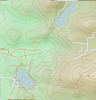
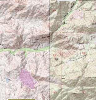
10 2. Get a Map Map Type: Basic: Streets & Roads Aerial: Satellite Imagery Terrain/Topo: Contour Lines Map Format: Raster: image/paper scan Vector: routable, smaller size Online vs Offline: Inet?


11 What is a TOPO Map?? AERIAL MAP TOPO MAP TOPO MAP with shading

12 3. Define Itinerary GPS Data Types: Waypoints: point Routes: p2p Tracks: smooth p2p Tracks Routes GPS Data Formats:.GPX : wpt,routes&tracks.kml : wpt&tracks.kmz : compressed KML Free converter: GPSBabel

13 Computer + GPS ( + Printer ) PC/Mac NatGeo Topo! ExpertGPS TopoFusion Web Caltopo.com Gpsvisualizer.com Gmap4.php Garmin Basecamp Google Earth
 Create")

 Can load")
")
14 Caltopo.com (Free / Pro $) Create wpt/tracks Import/Export.gpx.kml Garmin USGS RASTER 24k Maps Excellent Printing / PDF Excellent video tutorials (About) Can load maps to Garmin 3D viz with Google Earth Offline mode too (limited) Multiple map sources (free) Extras:Weather, Snotel, Gauges


15 Caltopo.com Map Sources CalTopo USGS 24k OpenStreetMaps Google Terrain NatGeo/ArcGis USGS 24k OpenCycleMaps Google Earth / Hybrid


16 Garmin BaseCamp (free) Create wpt/routes/tracks Import/Export.gpx.kml Garmin USGS 24k VECTOR maps Good printing capabilities Good video tutorials (Help) Can load maps to Garmin 3D viz with Google Earth Multiple map sources ($$/free) Garmin maps are expensive
")


 Satellite")
17 Garmin BaseCamp Map Sources Garmin ($$) Topo US 24K gpsfiledepot.com Southwest USA Topo Garmin BirdsEye ($$) TOPO USGS Quads gpsfiledepot.com California USA Topo 2008 alternativaslibres.es OpenStreetMaps+Topo Garmin BirdsEye ($$) Satellite Imagery openfietsmap.nl

18 Google Earth (free) Create wpt/tracks in 3D High-def 3D sometimes Up to 20x zoom (vs 15x) Import/Export.kml Import.gpx & from GPS Excellent 3D View Excellent Aerial maps Other map sources MUST have internet NO guiding/routing

19 Smartphone with Apps Map Apps: GPS + Map GaiaGPS: Easy, ios/android, $$$ Locus Maps: vector maps, advanced BackcountryNav: No track guiding MANY more, try them out! Hiking Apps: GPS + Map + Info + Tracks WikiLocs: Hiking, Biking, 4x4, etc. EveryTrail: Mostly only hiking MANY more, try them out!


 Some replaceable battery Some extended")


20 GPS Receiver vs GPS Smartphone GPS Receiver GPS Smartphone Waterproof Waterproof/Shockproof Some waterproof, protective cases Battery 2 AA Batteries x 20h (share batteries with headlamp, filter, etc.) Some replaceable battery Some extended batteries External USB battery packs Solar/crank/stove chargers POI search With vector maps Some Online only, Some save offline Routing With routable vector maps Some Online only, Some save offline Applications Mapping & Navigation Camera, , Facebook, ebooks, Audiobooks, music, Google Maps, etc
 7.")
21 Using a GPS: Before the trip 1. Update Firmware / App (if needed) 2. Delete previous map/data (if needed) 3. Load/Download map (if needed) 4. Load/Download/Create wpt/tracks Smartphones: Use DropBox 5. Check map&data transferred ok 6. Print trip map on paper (as backup) 7. Pack map & compass along
 6.")
22 Using a GPS: At the trailhead 1. Power Saving: set display off after 15s, adjust screen brightness to min/max Smartphones: Airplane mode ON, GPS ON 2. Calibrate: compass & altimeter (if needed) 3. Orient the map: 3D view OFF, North Up ON 4. Reset odometer / trip computer / tracklog DO TO NOT DELETE wpt/routes/tracks! 5. Track recording ON (if not automatic) 6. Mark starting waypoint (ie: CAR)
 Tracking: record breadcrums f) Extras: Sunset/Sumrise, etc Beware of coordinate format & datum! Verify location on map makes sense!")
23 Using a GPS: During the trip Basic operations: a) Map: view my location, pan & zoom b) Set Destination: Guiding / Routing c) Trip Computer: distance, time, speed d) Mark Waypoint: record location e) Tracking: record breadcrums f) Extras: Sunset/Sumrise, etc Beware of coordinate format & datum! Verify location on map makes sense!`


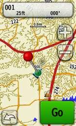
24 Demo: Garmin Oregon 450 Main Menu Destination: Waypoint Track Route Map Mark Wpt Guiding Trip Comp.


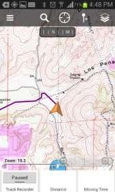

25 Map Demo: GaiaGps on Android Destination: Waypoint Track Switch / Downloading Maps Guiding Trip Computer

26 GPS : The Digital Map Luca Chiarabini lucach@gmail.com
Using a Garmin GPSMap 64s on a Senior Hike. By: Marilyn Warrant March 12, 2018
 Using a Garmin GPSMap 64s on a Senior Hike By: Marilyn Warrant March 12, 2018 Most of these definitions and instructions should also apply to other models of the Garmin GPSMap 64 and GPSMap 62. This document
GPS Tutorial for Hikers How to efficiently use your mobile as GPS navigator for hiking
 GPS Tutorial for Hikers How to efficiently use your mobile as GPS navigator for hiking By Marc TORBEY Examples from the Android software OruxMaps V1.0 1 Table of contents Basics about GPS for hiking slide
Add Maps With its microsd card slot and 1.7 GB of internal memory, etrex 30 lets you load maps.
 Garmin etrex 30 etrex 30 takes one of the most popular and reliable GPS handhelds and makes it better. Enhanced ergomics, an improved interface, paperless geocaching and expanded mapping capabilities makes
Stream Map USA Manual
 1. INTRODUCTION When Stream Map USA is launched, a map of North America opens showing your current location and a colored area highlighting the states covered. Stream Map USA Manual This manual is designed
GPSMAP 66. Owner s Manual
 GPSMAP 66 Owner s Manual 2018 Garmin Ltd. or its subsidiaries All rights reserved. Under the copyright laws, this manual may not be copied, in whole or in part, without the written consent of Garmin. Garmin
Handheld GPS Navigators. Garmin.com. Follow the leader Garmin Ltd. or its subsidiaries. All rights reserved M
 Handheld GPS Navigators Garmin.com Follow the leader. 2012 Garmin Ltd. or its subsidiaries. All rights reserved M01-10160-00 1212 Handheld GPS Navigators Whatever your sport or specialty, Garmin has a
NEW PRODUCT ANNOUNCEMENT
 2 September 2010 NEW PRODUCT ANNOUNCEMENT GPSMAP 62 series Colourful maps and durable design. The ultimate high performance outdoor handheld. GPSMAP 62 GPSMAP 62s Garmin Distribution Africa is pleased
DELORME. Earthmate. PN-Series. User Manual. Updated for 2.6 Firmware. GPS for Serious Outdoor Adventures
 DELORME Earthmate PN-Series User Manual Updated for 2.6 Firmware GPS for Serious Outdoor Adventures Earthmate PN-Series Accessories We offer a variety of products designed to carry, securely mount, and
GPSMAP 62 series quick start manual. For use with the GPSMAP 62, 62s, 62st, 62sc, and 62stc
 GPSMAP 62 series quick start manual For use with the GPSMAP 62, 62s, 62st, 62sc, and 62stc Getting Started warning See the Important Safety and Product Information guide in the product box for product
GPSMAP 64. Owner s Manual
 GPSMAP 64 Owner s Manual 2013 2016 Garmin Ltd. or its subsidiaries All rights reserved. Under the copyright laws, this manual may not be copied, in whole or in part, without the written consent of Garmin.
DELORME. Earthmate PN-60 GPS. User Manual
 DELORME Earthmate PN-60 GPS User Manual November 2011 Contents Getting Started... 3 Home Page... 9 Map Page... 10 Satellites Page... 18 Compass Page... 20 Trip Info Page... 22 Find Page... 24 Waypoints
Gps And Google Earth For Development How To Create Share And Collaborate With Maps On The Net
 Gps And Google Earth For Development How To Create Share And Collaborate With Maps On The Net We have made it easy for you to find a PDF Ebooks without any digging. And by having access to our ebooks online
quick start manual PERSONAL NAVIGATOR
 quick start manual foretrex 301 and 401 PERSONAL NAVIGATOR Battery Information The Foretrex operates on two AAA batteries. Use alkaline or NiMH batteries. Use precharged NiMH batteries for best results.
GPSMAP 78 series. quick start manual. for use with the GPSMAP 78, GPSMAP 78s, and GPSMAP 78sc
 GPSMAP 78 series quick start manual for use with the GPSMAP 78, GPSMAP 78s, and GPSMAP 78sc Getting Started warning See the Important Safety and Product Information guide in the product box for product
nüvi 500 Take It Anywhere Get Turn-by-Turn Directions Navigate Off-Road
 nüvi 500 Part Number: 010-00700-10 Drive, hike, bike or boat. With the rugged, waterproof, multi-mode nüvi 500, you can do it all. Packed with detailed street and topographic maps, nüvi 500 is ready for
Earthmate PN-60w GPS Details Key Features:
 Earthmate PN-60w GPS Details Key Features: Earthmate PN-60w with SPOT Satellite Communicator» 3.5 GB of internal flash memory» Intuitive icon-based user interface for easy on-device navigation» Elevation
GARMIN s GPS Map 76CSx
 GARMIN s GPS Map 76CSx DESCRIPTION: The GPSMAP 76CSx is a refreshing upgrade of the GPSMAP 76CS, one of our most popular models for outdoor and marine use. This unit features a removable microsd card for
 ➋ ➎ ➌ ➐ ➑ ➊ ➏ ➍ ➊ ➋ ➌ ➍ ➎ ➏ ➐ ➑ ➊ ➊ ➊ ➋ ➊ ➋ ➊ ➋ ➊ ➍ ➌ ➋ ➌ ➍ Power&Key&Customization& Power Key Customization What if we could take the power of the Favorites dashboard/status page combination and make
GPS Training
 Monterra Opens the doors to Maps & Apps Garmin are slowly but thoughtfully moving us towards the delivery of information and mapping for the outdoors enthusiast by introducing connectivity to the internet
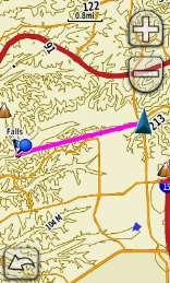
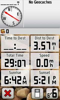
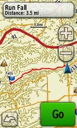
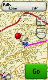
Geomorphology Lab 6: GPS Surveying
 Introduction In this lab you will use hand-held GPS receiver units to map a running trail on campus. In addition, you will take waypoints for the benchmarks used for the Total Station project. You will
GTI-GPS LOGGER AND ODOMETER
 GTI-GPS LOGGER AND ODOMETER Training & Software User Manual GTI Infotel 150 Pocket 1 Jasola New Delhi 110025 http://www.gtiinfotel.com GTI Infotel: GTI-GPS Logger and Odometer Training &User Manual Page
Using the Magellan explorist
 www.carid.com Using the Magellan explorist The Magellan explorist GPS receiver is designed to be easy enough for the casual explorer as well as having all of the advance features the enthusiast requires.
DELORME Earthmate PN-60 GPS
 DELORME Earthmate PN-60 GPS User Manual The Latest and Most Comprehensive PN-Series Information is Always Online! User Manuals, Getting Started Info, Tutorials The DeLorme Wiki is your link to comprehensive
GPS for Scouts LEAD 2018
 GPS for Scouts LEAD 2018 Steve von Ehrenkrook steve@cjsassociates.com 1 Introductions Steve von Ehrenkrook Geographer Cartographer Scoutmaster Orienterrerrerr 2 MOST Important Goal as Scouters? SAFETY!!
montana 600 series quick start manual for use with models 600, 650, 650t Montana 600 Series Quick Start Manual 1
 montana 600 series quick start manual for use with models 600, 650, 650t Montana 600 Series Quick Start Manual 1 Getting Started warning See the Important Safety and Product Information guide in the product
GPS Training
 About Data Fields, Dashboard, Information Windows, Trip and Housekeeping For many GPS enthusiasts being able to review their performance after a days walking is very satisfying; this is where a GPS really
nüvi 205 nüvi 205W nüvi 215 nüvi 215W nüvi 1200 nüvi 1300 nüvi 1310 nüvi 1410 nüvi 500 zūmo 660
 nüvi 205 nüvi 205W nüvi 215 nüvi 215W nüvi 1200 nüvi 1300 nüvi 1310 nüvi 1410 nüvi 500 zūmo 660 AUTOMOTIVE Product Catalogue - 20 November 2009 nüvi 205 nüvi 205W Display 205: Display 205W: 3.5" (8.9 cm)
1. Specifications for GARMIN GPS etrex 10
 ORBITAL AFRICA sales@orbital.co.ke +254-719672296 Tried & Tested 1. Specifications for GARMIN GPS etrex 10 Unit dimensions, WxHxD:, WxH: Display resolution, WxH: : : Battery: : Waterproof: Floats: : :
etrex quick start manual for use with models 20 and 30
 etrex quick start manual for use with models 20 and 30 Getting Started Device Overview warning See the Important Safety and Product Information guide in the product box for product warnings and other important
Off Road Navigation and Location-Based Photomarking & Blogging. 8/4/2005 The Best GPS is the one you have with you 1
 Off Road Navigation and Location-Based Photomarking & Blogging 8/4/2005 The Best GPS is the one you have with you 1 Always active Never lost, Trimble Outdoors TM The BEST GPS is the one you have with you
Revisions. Initial Release A 10/15/2010 Initial release with basic functions
 Revisions Initial Release A 10/15/2010 Initial release with basic functions Safety Warnings The Magellan explorist is a navigation aid designed to assist you in arriving at your selected destination. When
GPS 72H. quick start manual
 GPS 72H quick start manual 190-01119-01_0A.indd 1 7/22/2009 3:44:22 PM See the Important Safety and Product Information guide in the product box for product warnings and other important information. Manual
Setting up a GPS Unit and Basic GPS Mapping Techniques Manual
 Setting up a GPS Unit and Basic GPS Mapping Techniques Manual 1 Introduction This manual is intended to provide users with a basic understanding of a Garmin etrex GPS receiver and how it can help to support
Magellan explorist 310. User Manual
 Magellan explorist 310 User Manual www.magellan.com.au MiTAC Digital Corporation 471 El Camino Real, Santa Clara, CA 95050 USA www.magellangps.com Revisions Initial Release B /1 /201 Initial release with
GPS Training
 A Walk through Pages, Buttons, Keys and Menus Introduction Even though almost every handheld GPS more or less delivers the same basic features: Mark, Waypoints, Routes and Tracks - most GPS units, even
Back Country Navigator (BCN) Instructions and File Links
 Instructions and File Links") Instructions and File Links for Installing My Maps in Back Country Navigator, Orux Maps, and Garmin GPS s. BobT, updated 6/10/17 This is a lengthy document since I have tried to go into great detail with
Instructions and File Links for Installing My Maps in Back Country Navigator, Orux Maps, and Garmin GPS s. BobT, updated 6/10/17 This is a lengthy document since I have tried to go into great detail with
montana 600 series quick start manual for use with models 600, 650, 650t Montana 600 Series Quick Start Manual 1
 montana 600 series quick start manual for use with models 600, 650, 650t Montana 600 Series Quick Start Manual 1 Getting Started warning See the Important Safety and Product Information guide in the product
Magellan explorist 110. User Manual. MiTAC Australia Pty LTD Suite 2, 408 Victoria Road, Gladesville, NSW 2111, Austrailia
 Magellan explorist 110 User Manual MiTAC Australia Pty LTD Suite 2, 408 Victoria Road, Gladesville, NSW 2111, Austrailia www.magellangps.com.au IMPORTANT SAFETY WARNINGS The Magellan explorist GC receiver
free take one Spring/Summer 2011 GPS Solution Guide Find your adventure The latest in GPS and accessories for the total travel solution.
 free take one Spring/Summer 20 GPS Solution Guide Find your adventure The latest in GPS and accessories for the total travel solution. Visit to learn more. We ve got what you re looking for GPS devices
Track Kit App Reference Guide: Collecting Waypoints, Tracks and Photos
 This reference guide outlines how to use the Track Kit & Track Kit Pro smartphone app to collect geospatial field data, including waypoints, tracks, and photos. Track Kit is a simple app for ios and Android
FoxtrotGPS. GTK+ mapping and GPS application. The FoxtrotGPS team
 FoxtrotGPS GTK+ mapping and GPS application The FoxtrotGPS team This manual is for FoxtrotGPS (version 1.2.0, 24 October 2014). This document is licensed under a Creative Commons Attribution-ShareAlike
NAVIGATION USER MANUAL
 NAVIGATION USER MANUAL POWERED by Welcome Dear Customer, Thank you for selecting NDrive as your navigation software. This guide is created so that you can find quick and simple answers to your questions,
LEADNAV GPS. QUICK GUIDE Version Sept Patents Pending
 LEADNAV GPS QUICK GUIDE Version 3.0 - Sept 2015 Patents Pending MAIN NAV DISPLAY MENU Interact with Collections CENTER Use this to snap back to you re position ZOOM PAUSE / PLAY while running a route GPS
Astro. 320 with DC 50 Owner s Manual. June _0B Printed in Taiwan
 Astro 320 with DC 50 Owner s Manual June 2013 190-01628-00_0B Printed in Taiwan All rights reserved. Under the copyright laws, this manual may not be copied, in whole or in part, without the written consent
AUTOMOTIVE Product Catalogue - 20 September nüvi 1200T. nüvi 1300 nüvi 1300T nüvi nüvi nüvi 500. zūmo 220 Europe zūmo 660 Europe
 nüvi 1200 nüvi 1200T nüvi 1300 nüvi 1300T nüvi 1310 nüvi 1410 nüvi 500 zūmo 220 Europe zūmo 660 Europe AUTOMOTIVE Product Catalogue - 20 September 2010 G i Di t ib ti Af i (Pt ) Ltd ("GDA") th i ht t d
Owner s Manual. Colorado. Series. all-terrain GPS navigator
 Owner s Manual Colorado all-terrain GPS navigator Series 2007 2008 Garmin Ltd. or its subsidiaries Garmin International, Inc. 1200 East 151st Street, Olathe, Kansas 66062, USA Tel. (913) 397.8200 or (800)
Introduction. Features of NAVA F Series
 0 User Manual Introduction WARNING Please see the Important Safety and Product Information in the appendix for the product warnings, EULA and other important information before you use the NAVA device.
Table of contents. USERGUIDE_V11_ENG_Android
 FOR Table of contents Welcome to NDrive!... 3 V11 Highlights... 3 Main Map Screen... 3 Basic Interaction... 6 Exploring menu screens... 6 Using keyboards... 6 Performing a search... 8 Go screen... 9 How
GPS Guide. for District 37 Desert Races
 GPS Guide for District 37 Desert Races How To Bring Your Club into the 21 st Century, and also Save everybody time Reduce Rescue-3 response time Have accurate maps Get free help! Contents: Basic Instructions
BMW Motorrad. 1BMW Motorrad USA RA Rally Barber Motorsports Park
 1BMW Motorrad USA Page BMW Motorrad Navigator RA BMW Motorrad USA Rally Page 2 Getting more out of the BMW Navigator V: The power users seminar Ben Johnson Ben Johnson, Technical Sales & Marketing Manager,
Astro 430. Owner s Manual
 Astro 430 Owner s Manual June 2016 190-02079-00_0A All rights reserved. Under the copyright laws, this manual may not be copied, in whole or in part, without the written consent of Garmin. Garmin reserves
rino 600 series owner s manual
 rino 600 series owner s manual 2011 Garmin Ltd. or its subsidiaries All rights reserved. Under the copyright laws, this manual may not be copied, in whole or in part, without the written consent of Garmin.
Table of contents. Main Map Screen... 2 Basic Commands... 5 Exploring menu screens... 5 Using keyboards... 5 Performing a search...
 Table of contents Welcome!... 2 Main Map Screen... 2 Basic Commands... 5 Exploring menu screens... 5 Using keyboards... 5 Performing a search... 7 Go screen... 7 How to Navigate... 8 Navigate to an address...
MEDALLION INSTRUMENTATION SYSTEMS VIPER CHART PLOTTING OPERATORS MANUAL
 MEDALLION INSTRUMENTATION SYSTEMS VIPER CHART PLOTTING OPERATORS MANUAL TABLE OF CONTENTS Map Screen... 3 Squash Pad... 4 Navigation Menu Map View... 5 Orient View... 6 Select Course... 7 Creating a New
Gmap4 Using An Open Map By: Joseph Elfelt
 Gmap4 Using An Open Map By: Joseph Elfelt Last update to this file: February 24, 2017 For more documentation see the Gmap4 Help page Also see the What is new page Table of contents Introduction.............................................................
What s in the box? Initial setup. Remove MicroSD card from 1. pack from unit. SD card adapter and insert into MicroSD card slot.
 QUICK-START GUIDE What s in the box? Initial setup Micro SD reader Remove battery Remove MicroSD card from 1. pack from unit. 2. SD card adapter and insert into MicroSD card slot. Active 20 GPS device
GPS Essentials. This guide may be downloaded as gps-essentials_en.odt or gps-essentials_en.pdf Reviewed
 GPS Essentials GPS Essentials This guide may be downloaded as gps-essentials_en.odt or gps-essentials_en.pdf Reviewed 2015-05-24 Installation of GPS Essentials 1. Tap the Google Play Store app icon on
Using Track Kit App for Lyme Preserves Trail Report
 Using Track Kit App for Lyme Preserves Trail Report Track Kit App Reference Guide: Collecting Tracks, Waypoints and Photos Track Kit is an easy-to-use smartphone app for recording paths that works like
Introducing the Garmin zūmo 590LM Premium Motorcycle Navigator
 Introducing the Garmin zūmo 590LM Premium Motorcycle Navigator Package Content Motorcycle mount and hardware Micro USB Cable zūmo 590LM Motorcycle Power Cable Battery Pack Automotive Suction Cup Mount
WILD 2400 ASSIGNMENT #1: GPS TUTORIAL*
 WILD 2400 ASSIGNMENT #1: GPS TUTORIAL* Overview: In this tutorial you will learn how to collect, download, and display data using a Garmin GPSMAP 64 unit, the DNRGPS Application, and Google Earth. For
LIDAR in the Pines SD Macintosh Version Boyd Ostroff 12/23/2018
 LIDAR in the Pines SD Macintosh Version Boyd Ostroff 12/23/2018 LIDAR in the Pines SD is a lower resolution version of LIDAR in the Pines HD converted to Garmin s traditional.img file format. Although
LIDAR in the Pines SD Windows Version Boyd Ostroff 12/22/2018
 LIDAR in the Pines SD Windows Version Boyd Ostroff 12/22/2018 LIDAR in the Pines SD is a lower resolution version of LIDAR in the Pines HD converted to Garmin s traditional.img file format. Although the
PROCEDURES FOR GETTING TRACK FILES FROM HAND HELD GPS RECEIVERS
 PROCEDURES FOR GETTING TRACK FILES FROM HAND HELD GPS RECEIVERS This is a compendium of contributed procedures for getting track files from various models of GPS-equipped devices. Comments, corrections,
M Spangler, G Wescom November 24, 2018
 GPS for Historical Mapping M Spangler, G Wescom November 24, 2018 Table of Contents Chapter Page Introduction 1 GPS System Review 3 Hand Held GPS Devices 5 GPSMAP 64st Main Pages 7 Configuration Settings
What is MapBuddy: The main toolbar: MapBuddy Reference Guide V1.0
 MapBuddy Reference Guide V1.0 What is MapBuddy: MapBuddy is a Windows application designed for searching, storing and displaying information on top of a Google Maps interface. MapBuddy has various optional
MotionX-GPS HD User Manual
 MotionX-GPS HD User Manual Revision 20.0 IMPORTANT NOTE: This is not the user manual for MotionX-GPS Drive HD. Please visit http://drivehd.motionx.com for this manual. 1 Table of Contents 1. Overview 3
Garmin DriveSmart 50/60/70
 Garmin DriveSmart 50/60/70 Owner s Manual 190-01921-00_0A Getting Started 6 Click Add a Device. WARNING See the Important Safety and Product Information guide in the product box for product warnings and
GPS Training
 About Basecamp & Garmin Maps Free Garmin PC based software for your Computer or Mac for route planning, user data management & user data transfer to/from GPS. Big changes have arrived for Garmin GPS owners
GPS Trailmasters. Step 2 - Transfer the Map to Your Garmin GPS
 Step 2 - Transfer the Map to Your Garmin GPS If Garmin BaseCamp is not already installed on your computer, download and install Garmin BaseCamp for Windows from the Garmin website. Connect your Garmin
Light weight(51g) Waterproof Hi-Res 1.4 LCD display Flexible portability
 Waterproof Hi-Res 1.4 LCD display Flexible portability") pro Light weight(51g) Waterproof Hi-Res 1.4 LCD display Flexible portability Bike Mount Wrist Strap Lanyard Ideal for various outdoor & sports activities Sports watch & Bike computer 2-in-1 Backlight &
pro Light weight(51g) Waterproof Hi-Res 1.4 LCD display Flexible portability Bike Mount Wrist Strap Lanyard Ideal for various outdoor & sports activities Sports watch & Bike computer 2-in-1 Backlight &
DELORME. Earthmate GPS PN-20. An All-in-One Handheld GPS Solution from DeLorme, the Leading Digital Mapping and GPS Company.
 DELORME Earthmate GPS PN-20 An All-in-One Handheld GPS Solution from DeLorme, the Leading Digital Mapping and GPS Company User Manual Earthmate GPS PN-20 Accessories We offer a variety of products designed
Topic 1: Getting started Topic 2: Finding a location... 5
 Navigating LISTmap Topic 1: Getting started... 3 1. What is LISTmap?... 3 2. Compatible browsers... 3 3. A quick look at LISTmap... 3 Topic 2: Finding a location... 5 1. Using the search bar... 5 2. Zooming...
User Manual Ituran GPS GPS 350
 User Manual Ituran GPS GPS 350 Table of contents Operation manual Quick start 1. Opening screen 2. Map display 3. Main Menu 4. Navigation 5. Route Manager 6. Settings 7. Ituran BIG 8. Map Manager 9. Help
MEDALLION INSTRUMENTATION SYSTEMS MasterCraft Viper system
 MEDALLION INSTRUMENTATION SYSTEMS 2010 MasterCraft Viper system MEDALLION INSTRUMENTATION SYSTEMS VIPER CHART PLOTTING OPERATORS MANUAL MAP SCREEN This manual will attempt to familiarize the
MOBILE. LuciadMobile DATA SHEET
 MOBILE LuciadMobile DATA SHEET V2017 V2017.0 DATA SHEET LuciadMobile enables the rapid development of geospatial situational awareness applications on mobile devices running Android, and is specifically
MotionX-GPS User Manual
 MotionX-GPS User Manual Revision 22.0 IMPORTANT NOTE: This is not the user manual for MotionX-GPS Drive. Please visit http://drive.motionx.com for this manual. Table of Contents 1. Overview 3 2. Menu 4
IMPORTANT SAFETY WARNINGS
 IMPORTANT SAFETY WARNINGS The Magellan explorist GC receiver is a navigation aid designed to assist you in arriving at your selected destination. When using the Magellan explorist GC receiver, these safety
OCEAN 7T. Technical presentation (ENGLISH) FURUNO ELECTRIC CO., LTD. All Rights Reserved.
 FURUNO ELECTRIC CO., LTD. All Rights Reserved.") OCEAN 7T Technical presentation (ENGLISH) Software technology Navigation software has been designed to make the most of Radio Ocean marine plotters. Works in Multi-Touch Screen Jeppesen charting technology
OCEAN 7T Technical presentation (ENGLISH) Software technology Navigation software has been designed to make the most of Radio Ocean marine plotters. Works in Multi-Touch Screen Jeppesen charting technology
CREATING A MANAGEMENT MAP
 LEVEL Basic MODULE 1 PEOPLE 1 BUDGET $ WHEN Anytime CREATING A MANAGEMENT MAP REPEAT As needed IN A NUTSHELL Creating an electronic map that can be easily updated as needed and stored in perpetuity Map
Garmin DriveTrack 70. Owner s Manual
 Garmin DriveTrack 70 Owner s Manual May 2016 190-02080-00_0A All rights reserved. Under the copyright laws, this manual may not be copied, in whole or in part, without the written consent of Garmin. Garmin
GPS Nothing comes close to a Cobra. Owner s Manual ENGLISH
 Owner s Manual GPS 1080 GLOBAL POSITIONING SYSTEM RECEIVER Nothing comes close to a Cobra Printed in China Part No. 480-146-P ENGLISH IMPORTANT INFORMATION Cautions and Warnings Caution: The user is responsible
TwoNav Delta 2.6 User s Manual
 http://www.compegps.com http://support.compegps.com 1 TwoNav Delta 2.6 User s Manual 1 Introduction... 6 2 Maintenance... 7 2.1 Battery Recharge... 7 2.2 Precautions... 7 2.3 Autonomy... 8 2.4 Connection
CL7 DISPLAY QUICK START MANUAL 6YD-F819U-E0
 CL7 DISPLAY QUICK START MANUAL 6YD-F819U-E0 Introduction WARNING See the Important Safety and Product Information guide in the product box for product warnings and other important information. Device Overview
Strava, TrainingPeaks, Strava, TrainingPeaks, MapMyFitness
 Weight 74 g 70 g 75 g 80 g Bezel material: Steel Stainless steel Stainless steel Stainless steel Glass material: Mineral crystal Mineral crystal Sapphire crystal Mineral crystal Case material: Polyamide
Magellan Triton. User Manual. Magellan Triton 200 Magellan Triton 300 Magellan Triton 400 Magellan Triton 500
 Magellan Triton User Manual Magellan Triton 200 Magellan Triton 300 Magellan Triton 400 Magellan Triton 500 Magellan Navigation, Inc. 960 Overland Court, San Dimas, CA 91773 IMPORTANT SAFETY WARNINGS The
WayteQ GPS Navigation x980bt User Manual. English Version
 WayteQ GPS Navigation x980bt User Manual Version Thanks for using WAYTEQ products! WAYTEQ reserves the rights of final interpretation of the manual. The product is subject to change without any further
GPSMAP 62 series owner s manual. For use with the GPSMAP 62, 62s, 62st, 62sc, and 62stc
 GPSMAP 62 series owner s manual For use with the GPSMAP 62, 62s, 62st, 62sc, and 62stc 2010 2011 Garmin Ltd. or its subsidiaries Garmin International, Inc. 1200 East 151st Street, Olathe, Kansas 66062,
Change the way. you explore. the Canadian. Outdoors! HElp
 Change the way you explore the Canadian Outdoors! HElp ADVENTURE LAYERS AVAILABLE PROVINCES CONTENTS 2. Welcome to BACKROAD Navigator 3. Choose your province 4. Home/Sidebar Navigation 8. Partner Pages
GPS Training
 Maps for your GPS - Maps for your PC Before we move on to discussing the use of Maps - both paper & digital with a GPS - it is worth saying that many walkers have no wish to use GPS beyond a basic level,
Geocaching Buddy. V8 Quick Start Guide. April, BtStSoft Quick Start Guide, Page 1
 Geocaching Buddy V8 Quick Start Guide April, 2015 BtStSoft Quick Start Guide, Page 1 Introduction 3 Getting caches in the app 4 Adding waypoint formulas 5 Edit using a browser 6 More about formulas 8 All
GARMIN EXPLORE PROFESSIONAL WEB HELP. Owner s Manual
 GARMIN EXPLORE PROFESSIONAL WEB HELP Owner s Manual 2018 Garmin Ltd. or its subsidiaries All rights reserved. Under the copyright laws, this manual may not be copied, in whole or in part, without the written
How are you able to get unlimited range?
 User Guide 1 System Overview: Tell me about the New Quick Track Omni. The Quick Track OMNI system takes tracking to the next generation with unlimited range capability and an interactive app designed for
Find your way and reach your destination
 Find your way and reach your destination Outdoor GPS handheld devices and GPS wrist worn watches product overview GPS devices with touchscreen Montana 600 Montana 650 Dakota GPS devices with key operation
TWONAV DELTA 2.8 User manual
 http://www.compegps.com http://support.compegps.com 1 TWONAV DELTA 2.8 User manual 1 Introduction... 6 2 Start up & Maintenance... 7 2.1 Care instructions... 7 2.2 Basic parts of the device... 7 2.3 Mounting...
TwoNav iphone/ipad/android 2.6 User s Manual
 http://www.compegps.com http://support.compegps.com 1 TwoNav iphone/ipad/android 2.6 User s Manual 1 Introduction... 6 2 General description... 7 2.1 Navigation window... 7 2.1.1 Tool bar... 10 2.1.2 Data
SE 3S03 - Tutorial 1. Zahra Ali. Week of Feb 1, 2016
 SE 3S03 - Tutorial 1 Department of Computer Science McMaster University naqvis7@mcmaster.ca Week of Feb 1, 2016 testing vs Software Devices and s Devices and s App Device Outline testing vs Software Devices
Welcome! Presented by Paul Pearson National Corvette Museum, August 28, 2014
 Welcome! Presented by Paul Pearson National Corvette Museum, August 28, 2014 Linking IP to Driver Mode Selector If your car IP gauges don t change when you turn the driver mode selector, you just need
TALKABOUT WALKIE-TALKIES OWN EVERY MOMENT
 TALKABOUT WALKIE-TALKIES OWN EVERY MOMENT OWN EVERY MOMENT At the park with your kids, on the beach with friends or a keen adventurer enjoying a day out, Talkabout walkie-talkies from Motorola Solutions
WayteQ GPS Navigation X960BT User Manual. English Version
 WayteQ GPS Navigation X960BT User Manual English Version Thanks for using WAYTEQ products! WAYTEQ reserves the rights of final interpretation of the manual. The product is subject to change without any
TALKABOUT WALKIE-TALKIES OWN EVERY MOMENT
 TALKABOUT WALKIE-TALKIES OWN EVERY OWN EVERY At the park with your kids, on the beach with friends or a keen adventurer enjoying a day out, Talkabout walkie-talkies from Motorola Solutions are a great