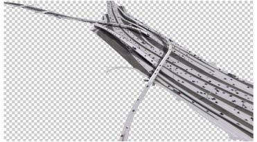
3D Visualization of the 14.4 Mile Multi-lane, Multi-level DFW Connector Corridor in North Texas
|
|
|
- Russell Bond
- 5 years ago
- Views:
Transcription
1 3D Visualization of the 14.4 Mile Multi-lane, Multi-level DFW Connector Corridor in North Texas Jeff Christiansen Managing Director of Visual Science & Technology
2 Real or Not?
3 Why is 3D visualization needed?
4 Why is 3D visualization needed? Stakeholder awareness

5 Some of the 200 miles of roadway visualized in North Texas
6 Typical Starting Point
7 Typical Starting Point Very detailed schematics with every layer imaginable turned on, such that the general public cannot engage in an educated discussion. The visualization allows a discussion to occur efficiently and in a public forum.

8 Look familiar?

9
10

11

12

13

14

15

16

17
18
19

20
21
22

23
24 Real or Not?
25 60% Project Deliverable Prior to signature landmark/building/geographical structures being added to the 3D model, a roadway design review is completed of the entire corridor, regardless of size. We are typically the first to try and tie all the 2D elements together in a 3D manner an eye opener for everyone involved. Bridge alignments are usually the problematic areas, with ROW constraints being a very close second. Aesthetic treatments are becoming more important.

26

27

28

29

30

31

32

33

34

35

36
37 Real or Not?
38 DVD Presentation
39 DFW Connector Specifics Number of animated lanes of traffic
40 DFW Connector Specifics Number of animated lanes of traffic 174
41 DFW Connector Specifics Number of animated lanes of traffic 174 Number of animated vehicles in the scene
42 DFW Connector Specifics Number of animated lanes of traffic 174 Number of animated vehicles in the scene 7,451
43 DFW Connector Specifics Number of animated lanes of traffic 174 Number of animated vehicles in the scene 7,451 Number of parked vehicles
44 DFW Connector Specifics Number of animated lanes of traffic 174 Number of animated vehicles in the scene 7,451 Number of parked vehicles 19,996
45 DFW Connector Specifics Number of animated lanes of traffic 174 Number of animated vehicles in the scene 7,451 Number of parked vehicles 19,996 Number of placed trees
46 DFW Connector Specifics Number of animated lanes of traffic 174 Number of animated vehicles in the scene 7,451 Number of parked vehicles 19,996 Number of placed trees 143,681 (6 predominant species)
47 DFW Connector Specifics 51,324 polygons

48 DFW Connector Specifics 51,324 polygons

49 DFW Connector Specifics 51,324 polygons

50 DFW Connector Specifics 210,971 Polygons

51 DFW Connector Specifics 210,971 Polygons
52 DFW Connector Specifics 210,971 Polygons
53 DFW Connector Specifics Total Vehicle Polygons =? Total Tree Polygons =?
54 DFW Connector Specifics Total Vehicle Polygons =? 601,135,600 Total Tree Polygons =?
55 DFW Connector Specifics Total Vehicle Polygons =? 601,135,600 Total Tree Polygons =? 14,451,542,000
56 3D Visualization frames a second / 1800 frames a minute think digital flipbook Each digital frame is rendered separately Each *.jpg can take 5 hours to render
57 DFW Connector Specifics A total of 25,200 frames were rendered for the final deliverable A standard definition frame is 720 x 405 pixels, while a high definition frame is 1,920 x 1,080 pixels.
58 DFW Connector Specifics A total of 25,200 frames were rendered for the final deliverable A standard definition frame is 720 x 405 pixels, while a high definition frame is 1,920 x 1,080 pixels. Slowest Computers = 5 hours to render a single frame 126,000 hours of rendering time (14.4 years)
59 DFW Connector Specifics A total of 25,200 frames were rendered for the final deliverable A standard definition frame is 720 x 405 pixels, while a high definition frame is 1,920 x 1,080 pixels. Slowest Computers = 5 hours to render a single frame 126,000 hours of rendering time (14.4 years) and Fastest Computers = 0.2 hours to render a single frame 5,040 hours of rendering time (0.57 years)
60 DFW Connector Specifics A total of 25,200 frames were rendered for the final deliverable A standard definition frame is 720 x 405 pixels, while a high definition frame is 1920 x 1080 pixels. Slowest Computers = 5 hours to render a single frame 126,000 hours of rendering time (14.4 years) and Fastest Computers = 0.2 hours to render a single frame 5,040 hours of rendering time (0.57 years) A total of 335,000 frames were rendered throughout the project.
61 DFW Connector Specifics Rendering in multiple layers due to complexity
62 DFW Connector Specifics
63 DFW Connector Specifics
64 DFW Connector Specifics
65 DFW Connector Specifics
66 DFW Connector Specifics
67 DFW Connector Specifics

68 DFW Connector Specifics
69 DFW Connector Specifics

70 DFW Connector Specifics

71 DFW Connector Specifics
72 DFW Connector Specifics

73 DFW Connector Specifics
74 DFW Connector Specifics Finished at the 11 th hour!...?

75 DFW Connector Specifics
76 DFW Connector Specifics

77 DFW Connector Specifics

78 DFW Connector Specifics
79
80
81


82
83 How do we do it?
84 How do we do it? With a 120 Computer / 280 Core Renderfarm!

85 6 TB s of Total Storage Capacity ~ DFW Connector needs 258 GB s of space ~
86 Real or Not?
87 Real or Not?
88 Real or Not?


89 Jeff Christiansen Managing Director of Visual Science & Technology 1201 North Bowser Rd. Richardson, TX Direct Mobile Fax
NORTH HOUSTON HIGHWAY IMPROVEMENT PROJECT (NHHIP): SEGMENT 3
: SEGMENT 3") NORTH HOUSTON HIGHWAY IMPROVEMENT PROJECT (NHHIP): SEGMENT 3 Varuna A. Singh August 17, 2018 NHHIP OVERVIEW Project divided into three segments: Segment 1: I-45: from Beltway 8 to I-610 (9 mi) 45 Segment
NORTH HOUSTON HIGHWAY IMPROVEMENT PROJECT (NHHIP): SEGMENT 3 Varuna A. Singh August 17, 2018 NHHIP OVERVIEW Project divided into three segments: Segment 1: I-45: from Beltway 8 to I-610 (9 mi) 45 Segment
THE SOUTHERN GATEWAY MANAGED LANES PROJECT. Public Meetings Summer 2015 June 23, June 25, July 7, July 9
 THE SOUTHERN GATEWAY MANAGED LANES PROJECT Public Meetings Summer 2015 June 23, June 25, July 7, July 9 History & Background Began in 2001 as a Major Investment Study (MIS), Schematic, and Environmental
From Integrated Corridor Management To Integrated Regional Mobility
 From Integrated Corridor Management To Integrated Regional Mobility Agenda Regional Mobility Dallas ICM Operational Needs Expansion and Enhancements Transit Improvements MPO s Leadership Future Direction
SAFETY ON THE IH 35 EXPANSION PROJECTS. Andy Petter, P.E. - Waco District
 SAFETY ON THE IH 35 EXPANSION PROJECTS Andy Petter, P.E. - Waco District Presentation IH 35 Expansion through the Waco District Safety Requirements on the Projects IH 35 Safety Summit Meetings Crash Data
MARTA BOARD OF DIRECTORS OCTOBER 4, 2018
 MARTA BOARD OF DIRECTORS OCTOBER 4, 2018 TODAY S AGENDA o Key driver of the program o Recommended plan o Project summaries o Next steps 2 KEY DRIVER: PUBLIC INPUT o Atlanta City Design o Atlanta s Transportation
Mountain Corridor Incident Management Program
 Mountain Corridor Incident Management Program Colorado Department of Transportation Background The I- Incident Management study was initiated in response to CDOT s I- MIS. The resulting program was the
SysAdmins Unleashed!
 SysAdmins Unleashed! Jon Geibel Director of Systems Ron Johnson Technology Manager Walt Disney Animation Studios 1 Founded, October 1923 First animated feature, Snow White and the Seven Dwarfs, 1937 Frozen
Central Corridor. - Central Corridor. Management Committee, Light Rail Transit. Rail-Volution - Weaving Transit into Existing Communities
 - Central Corridor Rail-Volution - Weaving Transit into Existing Communities Management Committee, October 31, 2009 June Improving 11, 2008 mobility Easing congestion Strengthening our communities Twin
8/8/2018 Council Approval Presentation. 8/14/2018 MOVEBR Infrastructure Enhancement and Traffic Mitigation Plan 1
 8/8/2018 Council Approval Presentation 8/14/2018 MOVEBR Infrastructure Enhancement and Traffic Mitigation Plan 1 Speaker Panel Jamie Setze Executive Director, Capital Regional Planning Commission Stephen
Memorandum CITY OF DALLAS
 Memorandum DATE March 22, 2013 CITY OF DALLAS TO SUBJECT Members of the Transportation and Environment Committee: Linda L. Koop (Chair), Sheffie Kadane (Vice Chair), Sandy Greyson, Delia Jasso, Vonciel
How-To Guide for Online Training
 How-To Guide for Online Training Where to Go to Class CASAS Online Self-Paced Courses are delivered using The online self-paced courses developed by CASAS are made possible through the course management
GRID. Geospatial Roadway Inventory Database. Michael Chamberlain, TxDOT. TPP Planning Conference Houston, TX
 GRID Geospatial Roadway Inventory Database Michael Chamberlain, TxDOT TPP Planning Conference - 2016 Houston, TX Topics 1 2 3 4 5 6 7 8 History (pre GRID) 3-6 GIS Resources 7-8 The Project 9-11 Assets
Creating Dallas-Fort Worth s Transportation System: Celebrating Partnerships and Milestones
 Creating Dallas-Fort Worth s Transportation System: Celebrating Partnerships and Milestones Presentation to the Texas Transportation Commission August 27, 2014 Presenters Mike Cantrell Commissioner, Dallas
Council of State Governments. Takoma Langley Transit Center Purple Line Project Briefing. October 28, 2013
 Council of State Governments Takoma Langley Transit Center Purple Line Project Briefing October 28, 2013 Takoma Langley Transit Center Purpose and Need Provide a safe, attractive and efficient facility
The Piedmont Corridor
 Richard E. Mullinax, PE, PTOE, CPM 27 March 2018 Piedmont Corridor Part of Federal Southeast Corridor 1992 Federal Railroad Administration designated Southeast High Speed Rail Corridor Important Freight
Welcome to the 2009 General Assembly
 Welcome to the 2009 General Assembly Development Excellence : Illustrated Issues Facing the Region Transportation Air Quality Water Supply Environment Mission Statement: Center of Development Excellence
Project Summary. Feb. 2014
 Project Summary Feb. 2014 2 Cooperative Transportation Systems Pooled Fund Study Overview Program to support the development and deployment of Cooperative Transportation Systems Applications Goals To facilitate
VTU QUESTION PAPER SOLUTION UNIT -1 INTRODUCTION
 VTU QUESTION PAPER SOLUTION UNIT -1 INTRODUCTION 1. Briefly explain any two applications of computer graphics. (June 2012) 4M Ans: Applications of computer graphics are: Display Of Information Design Simulation
Executive Summary. City of Goodyear. Prepared for: Prepared by: November, 2008 Copyright 2008, Kimley-Horn and Associates, Inc.
 Goodyear Intelligent Transportation Systems Strategic Plan Executive Summary Prepared for: City of Goodyear Prepared by: 191376000 Copyright 2008, Kimley-Horn and Associates, Inc. I. INTRODUCTION The City
NORTH SIDE IMPACT ANALYSIS
 NORTH SIDE IMPACT ANALYSIS INDOT INTERSTATE PROJECTSS Heavy investment in a fifty-year-old central Indiana interstate system is in process, and unless redirected, will incrementally embed the system s
3D Design Overview.
 3D Design Overview vern.danforth@dot.state.fl.us Typical Plans Set 2D Plans 2D Design Plans History: Why create 2D Plans? FDOT Contract requirements Engineer s sign and seal paper for accountability Provide
Large Scale Data Visualization. CSC 7443: Scientific Information Visualization
 Large Scale Data Visualization Large Datasets Large datasets: D >> 10 M D D: Hundreds of gigabytes to terabytes and even petabytes M D : 1 to 4 GB of RAM Examples: Single large data set Time-varying data
Automated Road Segment Creation Process
 David A. Noyce, PhD, PE Director and Chair Traffic Operations and Safety Laboratory Civil and Environmental Engineering Department Kelvin R. Santiago, MS, PE Assistant Researcher Traffic Operations and
Representing the Real World
 Representing the Real World The theory of representing the real world in a GIS using digital data The nature of digital data and binary notation The discrete object view of the world Entities, data objects,
Mobile Mapping Solutions for Ohio s Integrated Transportation Network. Brian Foster, CP
 Mobile Mapping Solutions for Ohio s Integrated Transportation Network Brian Foster, CP About Woolpert Established in 1911 Over 600 Professionals 25 Offices $12,000,000 invested in new technology in last
Engaging Maryland toward CAV advancements Christine Nizer, Administrator
 Engaging Maryland toward CAV advancements Christine Nizer, Administrator Maryland Department of Transportation Motor Vehicle Administration Maryland CAV activities Overall goal: Maryland is open for business
ITS Wisconsin Transportation Conference October 23, 2018
 ITS Wisconsin Transportation Conference October 23, 2018 1 2 3 FACILITY HIGHLIGHTS Skidpad VDA Main Campus Handling Courses North Campus 7.5 Mile Oval 4 NORTH CAMPUS HIGHLIGHTS Emissions Laboratory Impact
Traveler Information System
 Traveler Information System Regional Safety Advisory Committee January 27, 2017 Marian Thompson, P.E. Transportation System Operations Supervisor 511DFW.org 511DFW Regional in DFW Multimodal 2 511DFW.org
1.0 PURPOSE AND NEED
 1.0 PURPOSE AND NEED This chapter documents the need for transit improvements in the Northwest Corridor and the purposes that the proposed project is intended to serve. An overview of the study corridor
Introduction to Computer Graphics
 Introduction to 1.1 What is computer graphics? it would be difficult to overstate the importance of computer and communication technologies in our lives. Activities as wide-ranging as film making, publishing,
Road Intersections Near Level Crossings: Intersection Awareness in Illinois. Brian Vercruysse Illinois Commerce Commission
 Road Intersections Near Level Crossings: Intersection Awareness in Illinois Brian Vercruysse Illinois Commerce Commission Illinois Freight & Passenger Rail Systems Metra Commuter Illinois Rail Crossing
190 + DALLAS NORTH TOLLWAY DALLAS, TEXAS
 190 + DALLAS, TEXAS FRISCO LEWISVILLE 35 SOUTHLAKE COPPELL GRAPEVINE 121 DFW AIRPORT 360 BELTLINE ROAD 161 635 114 IRVING GRAND PRAIRIE 121 30 CARROLLTON 12 THE OFFICES OF BUSH & TOLLWAY HIGHLAND PARK
Coordinated Highways Action Response Team
 Coordinated Highways Action Response Team PANEL 3: EVENT RESPONSE TOOLS YOU CAN USE AT YOUR AGENCY Richard R. Dye CHART Systems Administrator Maryland State Highway Administration I-95 CORRIDOR COALITION
DIGITAL COMPASS-RD DIGITAL COMPASS REFERENCE DESIGN KIT USER' S GUIDE. 1. Kit Contents. 2. Introduction. 3. Quick-Start Guide. 4. General Description
 DIGITAL COMPASS REFERENCE DESIGN KIT USER' S GUIDE 1. Kit Contents The Digital Compass Reference Design Kit contains the following items: C8051F350 Digital Compass Reference Design Board Silicon Laboratories
Virginia Connected Corridor
 Virginia Connected Corridor NATMEC 2016 Mike Mollenhauer Director, Center for Technology Implementation Virginia Tech Transportation Institute 5/4/2016 Virginia Connected Corridor In 2014, VDOT and VTTI
Texas Clear Lanes. Congestion Relief Initiative
 Texas Clear Lanes Congestion Relief Initiative March 2016 Governor Greg Abbott s Charge In September 2015, Governor Greg Abbott challenged the Texas Transportation Commission (Commission) and the (TxDOT)
Austin and San Antonio
 Chapter of the Association of Energy Engineers January 2015 Volume 10, Issue 1 Inside this issue: January Speaker 2 January Presentation/Tour 2 Happy New Year Austin - San Antonio Chapter members. A Note
Tolling Innovations and State Interoperability. Agenda
 Tolling Innovations and State Interoperability 2006 Summer TexITE Meeting Technical Program Fred Philipson, Assistant Director June 23, 2006 Agenda The PPP Question Operations More Electronic Toll Collection
Bentley OpenBridge Workshop 2017 FLUG Spring Training Event
 Bentley OpenBridge Workshop 2017 FLUG Spring Training Event 435 - Using Open Bridge Modeler and Lumenr RT Bentley Systems, Incorporated 685 Stockton Drive Exton, PA 19341 www.bentley.com Practice Workbook
STATE STREET CORRIDOR
 CITY OF WEST LAFAYETTE AND PURDUE UNIVERSITY STATE STREET CORRIDOR March 11, 2015 1 March 11, 2015 2 STATE STREET CORRIDOR AGENDA STATE STREET CORRIDOR 1. Project Fundamentals Project History Project Goals
Doug Couto Texas A&M Transportation Technology Conference 2017 College Station, Texas May 4, 2017
 Cyber Concerns of Local Government and What Does It Mean to Transportation Doug Couto Texas A&M Transportation Technology Conference 2017 College Station, Texas May 4, 2017 Transportation and Infrastructure
C Line Rapid Bus 90% Design
 C Line Rapid Bus 90% Design Karyssa Jackson, Community Outreach Coordinator Shawn Walding, Senior Engineer Metro Transit TAAC August 2, 2017 1 Today s Discussion Informational Feedback from February Project
SIMULATION AND ANALYSIS OF ARTERIAL TRAFFIC OPERATIONS ALONG THE US 61 CORRIDOR IN BURLINGTON, IOWA FINAL REPORT
 SIMULATION AND ANALYSIS OF ARTERIAL TRAFFIC OPERATIONS ALONG THE US 61 CORRIDOR IN BURLINGTON, IOWA FINAL REPORT Principal Investigator Tom Maze Principal Contributor Ali Kamyab Sponsored by the Engineering
Section 7 - Introducing Roadway Modeling
 Introducing Roadway Modeling Section 7 - Introducing Roadway Modeling Section Goals: Understand the Principles of InRoads Roadway Modeling Understand how to load Typical Section Libraries Understand how
Artlantis 2.1. Accelerating performance
 Artlantis 2.1 Accelerating performance The complexity of geometries, the increasing number of objects, and the quality of textures are constant challenges for developers aiming to accelerate the computing
Knowledge Base Article. Integrating ISONAS Access Control System with TagMaster LR-series RFID Readers
 Knowledge Base Article Integrating ISONAS Access Control System with TagMaster LR-series RFID Readers Copyright 2009-2013 ISONAS Security Systems All rights reserved Table of Contents 1: INTRODUCTION...
Raster GIS applications
 Raster GIS applications Columns Rows Image: cell value = amount of reflection from surface DEM: cell value = elevation (also slope/aspect/hillshade/curvature) Thematic layer: cell value = category or measured
BLUE RIBBON Facilities
 BLUE RIBBON 2015 Facilities FACILITY PRIORITIES Police Administration Addition $4,484,864 Relocation of Fire Station 3 $4,829,683 (Does not include land purchase) City Hall Basement/Conference/Training/Emergency
Crafting Your Innovative Network Infrastructure
 Crafting Your Innovative Network Infrastructure www.ipromedia.us Crafting Your Innovative Network Infrastructure Think about the software you use on your company desktop computer on a day to day basis.
Cedar Rapids ITS Deployment Project
 Cedar Rapids ITS Deployment Project Concept of Operations July 29, 2011 Table of Contents Section 1 Introduction Purpose Goal of ITS Deployments Section 2 Needs Assessment General Background Stakeholders
Overview September 7, 2017
 Overview September 7, 2017 Purpose The purpose of this presentation is to provide an overview of the changes to the required deliverables and workflow for developing plans and models for Illinois DOT projects
Indoor. Heritage Preservation CAD versus Cloud. inside. Applanix and CSIRO. Grows with LiDAR. Vol. 2 Issue 4 ABOVE & BEYOND. ipad & Tablet Ready!
 inside Indoor Mapping Applanix and CSIRO SMALL BUSINESS Grows with LiDAR Heritage Preservation CAD versus Cloud Vol. 2 Issue 4 ABOVE & BEYOND ipad & Tablet Ready! RE-MODELING THE MIXMASTER From Mobile
FOREST PARK GARDENS 9550 FOREST LN, DALLAS, TX 75243
 PROPERTY DETAILS BUILDING DETAILS Property Size: 82,077 SF LBJ Corridor, NE Dallas, North Dallas, Richardson Submarket Located in Building 3 24-Hour Programmable Access to All DIRECTIONS (Map) Buildings
Chapter 1: Introducing Roadway Modeling
 Introducing Roadway Modeling Chapter 1: Introducing Roadway Modeling Chapter Overview The chapter addresses the following topics: How Roadway Modeling Works in InRoads Opening and Exploring Typical Section
City Spotlight- City of Santa Clarita ITS Efforts. Andrew Yi, P.E., P.T.O.E City Traffic Engineer
 City Spotlight- City of Santa Clarita ITS Efforts Andrew Yi, P.E., P.T.O.E City Traffic Engineer About Santa Clarita Santa Clarita Downtown LA Located 30 miles northwest of Downtown LA Geographically isolated
Re: Developing Requirements for Mobile LiDAR Data (#1015)
") TM Tech Notes Certainty 3D April 10, 2012 To: General Release From: Ted Knaak Certainty 3D, Inc. Re: Developing Requirements for Mobile LiDAR Data (#1015) Introduction Recent discussions within the industry
TM Tech Notes Certainty 3D April 10, 2012 To: General Release From: Ted Knaak Certainty 3D, Inc. Re: Developing Requirements for Mobile LiDAR Data (#1015) Introduction Recent discussions within the industry
MESO & HYBRID MODELING IN
 MESO & HYBRID MODELING IN www.ptvgroup.com JONGSUN WON, P.E. www.ptvgroup.com I Slide 1 SOMETHING NEW WITH PTV NORTH AMERICA Portland, OR Arlington, VA www.ptvgroup.com I Slide 2 MULTIRESOLUTION MODELING
INTRODUCTION. What You Need to Read. What this LANbook Covers
 Qwest DSLSM LANbook INTRODUCTION What You Need to Read If you are self-installing Qwest DSL on a local area network in your home or business, start with Chapter 1: Welcome to the Qwest DSL LANbook on page
Aerial and Mobile LiDAR Data Fusion
 Creating Value Delivering Solutions Aerial and Mobile LiDAR Data Fusion Dr. Srini Dharmapuri, CP, PMP What You Will Learn About LiDAR Fusion Mobile and Aerial LiDAR Technology Components & Parameters Project
West Seattle and Ballard Link Extensions. Downtown Open House and Neighborhood Forum September 11, 2018
 West Seattle and Ballard Link Extensions Downtown Open House and Neighborhood Forum September 11, 2018 Agenda Why we re here today Alternatives development overview What we heard in Level 1 Level 2 alternatives
TxDOT TMS PERFORMANCE MEASURES ITS TEXAS Texas Department of Transportation
 TxDOT TMS PERFORMANCE MEASURES ITS TEXAS 2017 Texas Department of Transportation Traffic Management Systems November 2017 TRF-TM Update 1 2 Implementation of TMS Performance Metrics TMS Performance Metrics
Economic Crash Analysis Tool. Release Notes
 Release Notes August 2017 Release: 1. Project Information Worksheet: a. Update: Removed the design exception report option b. Enhancement: The first question has been expanded to provide better clarity
How much data can a BluRay hold?
 COMPUTER HARDWARE ICS2O MR. EMMELL HOW MUCH SPACE ON YOUR USB? How much RAM in your phone? How much data can a BluRay hold? 1 THAT WHOLE B/KB/MB/GB/TB THING THAT WHOLE B/KB/MB/GB/TB THING So how many Bytes
Wireless Support for Incident Response Information Management. ScenPro, Inc. Mark Swenholt 4/15/03
 Wireless Support for Incident Response Information Management ScenPro, Inc. Mark Swenholt 4/15/03 Incident Response Information Management Needs Responding Units Command Center Military Joint Forces Com
Computer Hardware. ICS2O Mr. Emmell
 Computer Hardware ICS2O Mr. Emmell How much space on your USB? How much RAM in your phone? How much data can a BluRay hold? That whole B/KB/MB/GB/TB thing That whole B/KB/MB/GB/TB thing So how many Bytes
Chief Executive Officer
 Chief Executive Officer Role Overview Reporting to: Package: Location: Jeremy Coller and the Trustees of the Foundation Six-figures (depending on experience) 116 Park Street, London, W1K 6AF Main Purpose
Performance and User Experience...2. Exceptional Performance Best Practices...2. Testing the xamwebgrid...3. Performance Results...
 Performance in the Infragistics xamwebgrid for Microsoft Silverlight An Infragistics Whitepaper Published September 1st, 2009 Contents Performance and User Experience...2 Exceptional Performance Best Practices...2
Future Studios Research Lab
 GPU TECHNOLOGY WORKSHOP SOUTH EAST ASIA 2014 Future Studios Research Lab The Boy and His Robot Film Case Study Prof SEAH Hock Soon Director Multi-plAtform Game Innovation Centre (MAGIC) Nanyang Technological
6111 WEST PLANO PARKWAY PLANO, TEXAS 75093
 6111 WEST WAY, TEXAS 75093 We partner in creating life-enhancing communities. BILLINGSLEY COMPANY 1722 ROUTH STREET SUITE 1313, TEXAS 75201 BILLINGSLEYCO.COM BILLINGSLEY COMPANY 2013. ALL RIGHTS RESERVED.
National Operations Center of Excellence
 Triennial Review National Operations Center of Excellence Thomas E. Kern NOCoE Managing Director Shailen Bhatt Chair, NOCoE Board of Directors 1 National Operations Center of Excellence Origins of NOCoE
City of Ithaca - Request for Traffic Calming Investigation
 City of Ithaca - Request for Traffic Calming Investigation If you would like to have the City Engineering Department consider your request for traffic calming, you will need to fill out the following sections
SmartCAM Install Guide. Page 1/14
 Page 1/14 Document version: 2017.02.09 Table of Contents INSTALL THE HARDWARE... 3 1. MOUNTING... 4 2. BRACKET DETAILS AND SIZES... 4 CABLE LAYOUTS... 5 SOFTWARE REQUIREMENTS... 7 ACCESSING THE CAMERA...
Tutorial 1: Finding and Displaying Spatial Data Using ArcGIS
 Tutorial 1: Finding and Displaying Spatial Data Using ArcGIS This tutorial will introduce you to the following: Websites where you may browse to find geospatial information Identifying spatial data, usable
STATE OF ALASKA RFP NUMBER 2516H009 AMENDMENT NUMBER ONE (1)
") STATE OF ALASKA RFP NUMBER 2516H009 AMENDMENT NUMBER ONE (1) AMENDMENT ISSUING OFFICE: Department of Transportation & Public Facilities Statewide Contracting & Procurement P.O. Box 112500 (3132 Channel
STATE OF ALASKA RFP NUMBER 2516H009 AMENDMENT NUMBER ONE (1) AMENDMENT ISSUING OFFICE: Department of Transportation & Public Facilities Statewide Contracting & Procurement P.O. Box 112500 (3132 Channel
Fire Scene 6. Tip Sheet
 Fire Scene 6 Tip Sheet Fire Scene 6 All rights reserved. No parts of this work may be reproduced in any form or by any means - graphic, electronic, or mechanical, including photocopying, recording, taping,
A New Approach To Robust Non-Intrusive Traffic Detection at Intersections!
 A New Approach To Robust Non-Intrusive Traffic Detection at Intersections! Chad Stelzig Algorithm Engineering, ISS! cstelzig@imagesensing.com! May 22 nd, 2013! Todayʼs Discussion Points! Background and
System Firmware Update Instructions for Pioneer In-Dash Navigation AV Receivers and DVD Receivers
 System Firmware Update Instructions for Pioneer In-Dash Navigation AV Receivers and DVD Receivers (AVH-X8850BT) This firmware update (version 1.07 for AVH) applies only to the following models of Pioneer
Design Visualization for Transportation Projects
 Design Visualization for Transportation Projects Ting Wei, PE, PTOE, AICP Paul Jarboe Presented at 99 th Annual Purdue University Road School March 6, 2013 Presentation Outline Types of Visualization Benefits
Identity Guidelines for MWSIP
 Identity Guidelines for MWSIP Identity Guidelines for Mahaweli Water Security Investment Program (MWSIP) C O N T E N T S Need for basic identity guidelines... 1 Expression of Program identity... 3 MWSIP
PROJECT TIMELINE. Next steps. Plan. Start of Service
 PROJECT TIMELINE 2018 2019 2020 2021 2022 2023 WE ARE HERE Plan Develop Build Develop design options for termini, station locations, and transit operations Conduct environmental research Assess funding
Rowland s Motion Graphics Video Process
 Rowland s Motion Graphics Video Process You know it s essential to tell your story as clearly as possible. Getting it right isn t as easy as it sounds. There s always one more product spec or customer
andretti brown creative designer
 andretti brown creative designer about I m a graphic designer with experience designing engaging and user-friendly interfaces (UI) and experiences (UX) along with other marketing graphics for large brands
A. INTRODUCTION B. PRINCIPAL CONCLUSIONS AND IMPACTS C. METHODOLOGY
 Chapter 15: Safety and Security A. INTRODUCTION This chapter discusses safety and security as they relate to the Proposed Project and summarizes how potential safety and security issues are identified
OUR LIFESTYLE RULES. Accept the. Success. Build. Partnerships Work Honestly. Work hard. Think smart
 OUR LIFESTYLE RULES Accept the Build Success Partnerships Work Honestly Work hard Think smart EXECUTIVE SUMMARY We live and breathe internet marketing We do SEO differently. In this proposal you ll notice
Transportation & Mobility
 Transportation & Mobility October 11, 2017 October 11, 2017 Community Dialogue Series Session 3: Transportation & Mobility YOU ARE NOT STUCK IN TRAFFIC. YOU ARE TRAFFIC. October 11, 2017 Community Dialogue
Raster GIS applications Columns
 Raster GIS applications Columns Rows Image: cell value = amount of reflection from surface Thematic layer: cell value = category or measured value - In both cases, there is only one value per cell (in
Adding Mobile App Payments at PacifiCorp
 Adding Mobile App Payments at PacifiCorp Industry Overview Rob Gilpin Changing Customer Expectations Then Fair value for fair price Responsive service Quality and reliability Courtesy and empathy Ease
A NORTH AMERICAN ROAD SAFETY PROFESSIONAL (RSP) CERTIFICATION
 CERTIFICATION") A NORTH AMERICAN ROAD SAFETY PROFESSIONAL (RSP) CERTIFICATION Paul Lorton, P.E. State Safety Engineer Bureau Chief, Safety Programs and Engineering Illinois Department of Transportation Slide 1 Outline
A NORTH AMERICAN ROAD SAFETY PROFESSIONAL (RSP) CERTIFICATION Paul Lorton, P.E. State Safety Engineer Bureau Chief, Safety Programs and Engineering Illinois Department of Transportation Slide 1 Outline
Chapter Eight: Contents
 Volume Three Modules 01 March 2002 i Chapter Eight: Contents (Output Visualizer 04 March 2002 LA-UR-00-1725 TRANSIMS 3.0) 1. INTRODUCTION...1 1.1 OVERVIEW... 1 1.2 REQUIREMENTS... 1 2. USING THE OUTPUT
ARLINGTON COUNTY, VIRGINIA
 ARLINGTON COUNTY, VIRGINIA County Board Agenda Item Meeting of October 15, 2016 DATE: October 11, 2016 SUBJECT: Request to ratify advertisement of public hearings by the Planning Commission and the County
I-95 Corridor Coalition. Multi-State VMT-Based Road-User Fee Initiative. Mark F. Muriello
 I-95 Corridor Coalition Multi-State VMT-Based Road-User Fee Initiative Mark F. Muriello Assistant Director Tunnels, Bridges and Terminals The Port Authority of NY & NJ Co-Chair Policy & Strategic Planning
Virginia Department of Transportation Hampton Roads Bridge-Tunnel Action Plan Implementing the Independent Review Panel Recommendations
 Virginia Department of Transportation Hampton Roads Bridge-Tunnel Action Plan Implementing the Independent Review Panel Recommendations Initial Panel Charge August 2009 To review existing policies and
Integrated Diagramming Tool Easy Street Draw
 Integrated Diagramming Tool Easy Street Draw CRASH User Guide - 1 Version Control Date Version Author(s) Section(s) Update(s) 8/24/2011 1 S Kirkpatrick, J Castillo, H Campbell, D Williams, M McCormick,
VTA s BART Silicon Valley Phase II Extension Project San Jose Downtown Association
 VTA s BART Silicon Valley Phase II Extension Project San Jose Downtown Association August 24, 2017 THANK YOU! San Jose Downtown Association for inviting us & San Jose First United Methodist Church for
3DVIA COMPOSER TECHNICAL TIPS
 3DVIA COMPOSER TECHNICAL TIPS 3DMOJO.COM A dedicated 3DVIA Composer Website for additional resources (i.e. Forums, Podcasts, etc.) HARDWARE SETTINGS FOR COMPOSER V6R2011 There are a couple of new settings,
SimTenero Particle Physics
 SimTenero Particle Physics Getting Started The heart of the particle system is the Emitter. This represents the point in space where particles will be created and contains all of the parameters that define
Continual Innovation Through Diverse Funding Sources. Paul Comfort, Esq. CEO, Maryland Transit Administration
 Continual Innovation Through Diverse Funding Sources Paul Comfort, Esq. CEO, Maryland Transit Administration Problem Statement and Solution Issue: Funding continues to dry up Declining Federal Formula
Character Modeling IAT 343 Lab 6. Lanz Singbeil
 Character Modeling IAT 343 Lab 6 Modeling Using Reference Sketches Start by creating a character sketch in a T-Pose (arms outstretched) Separate the sketch into 2 images with the same pixel height. Make
What s New in Desktop 10.1
 What s New in Desktop 10.1 Damian Spangrud Esri Redlands Trip Down Memory Lane ArcGIS A Complete System for Geographic Information Cloud Web Online Mobile Enterprise Desktop Sharing Information sharing