GeoSmartCity. open geo-data for innovative services and user applications towards Smart Cities
|
|
|
- Herbert Dean
- 5 years ago
- Views:
Transcription
1 GeoSmartCity open geo-data for innovative services and user applications towards Smart Cities CIP ICT-PSP Project n Start date , duration 36 months 1


 useful")

2 Open geo-data for innovative services and user applications towards Smart Cities GeoSmartCity implements a platform to share and public geographical open data coming from different sources, such as Public Administrations, Multi-utilities, Companies and Crowd-sourcing. The platform includes specialized web services to integrate public geographical data with other geo-refenced data (public or private) useful for the smart management of urban infrastructures and public services in the context of the Smart City initiative and the Digital Agenda for Europe. Partnership COMUNE DI GENOVA 2


 data")
3 Objectives Support Cities to open their data to professionals and citizens Establish a cross-platform, re-usable, able to publish open- (GI) data, in an urban context, but with a European dimension Provision of tools and facilities to integrate GI data/info with open data Framework and services to integrate proprietary/restricted data with open (GI) data of the City 3
4 Objectives vs Exploitation Open infrastructure to build new business model for PAs and SMEs PPP (Public Private Partnerships): collaborative management of Open(GI) data Integration of restricted data in a secure way 4
 Underground (6 pilot")
5 Objectives vs Exploitation Open infrastructure extandable to different SmartCity contexts Two application scenarios: Green Energy (5 pilot cases) Underground (6 pilot cases) 5
6 Harmonised environment to integrate different operational protocols and standards, based on existing infrastructures Re-use of specialized services based on open standards Integration of new base/specialized services Ingestion and data integration engine composed by: Harmonised data storage (based on GI standard, open data format) a set of ingestion and data relation services: Ingestion toolkit of GI data (open/restricted) ICT Objectives Ingestion toolkit of not-gi data (open/restricted) Refine and reconcile toolkit to link and interconnect data Crowd-sourcing base services based on location services 6
7 Outcomes 1. GI Open Data Repository and Target Data Models Open and proprietary datasets including geo-spatial information in an interoperable infrastructure based on open standards. 2. GeoSmartCity Hub A cross-platform, re-usable and open hub able to publish open geographic information and to provide specialised services based on open standards services. 3. Innovative Services Services platform to View, analyze, extract data from the GeoSmartCity OpenData Hub; Universal Discovery Services; BI and Geoprocessing service platform; Ingestion and data integration engine. 7
8 Outcomes 4. Green Energy Scenario Operative and re-usable pilot cases to facilitate diffusion and management of renewable energy within cities. 5. Underground Scenario Operative and re-usable pilot cases to support integrated management of underground utilities infrastructures 6. GeoSmartCity Training Framework Designed in order to make available existing knowledge and transfer the outcomes of the project towards the target groups of users. The Training Framework complements and support dissemination and exploitation, fostering Capacity Building 8
9 Road Map MAR 2014 Launch of the project first phase the analyses for system architecture data content MAR OCT 2014 Analysis Phase 2014 JUN 2014 Initiation of: Scenarios Model Design and Data Requirements for GSC client and hub AUG 2014 Initiation of Data Harmonisation OCT 2014 NOV 2014 Initiation of Scenarios Data Services Design Technical and functional requirements JUN 2014 FEB 2016 Initial Operating Capacity Phase DEC 2014 Initiation of Specialized services specification 2015 APR 2015 Initiation of clients development FEB 2015 Initiation of Specialized services Design JUN 2015 SEP2015 GSC Hub Integration FEB MAY 2016 AUG 2015 Data Harmonistion Report End user application deployment Scenarios Data Services Report AUG 2015 AUG 2016 Validation Phase JAN PA Validation and Tests Initiation of exploitation and sustainability FEB AUG 2016 Advanced Operating Capacity Phase FEB 2016 GSC HUB pre-release SEP 2016 OCT 2016 PA Analyses and Lessons Learnt PA OPERATIONAL AUG 2016 AUG 2016 FEB 2017 GSC HUB Final Operation 2017 FEB 2017 PA OPERATIONAL FINAL version GSC Toolkit Market and business plan 9


10 City Pilots and Scenarios Turku Flanders Region South Moravian Region Comarca of Pamplona Ruda Slaska (Katowice area) Reggio nell Emilia Girona Genova Oeiras Oeiras Maroussi UNDERGROUND GREEN ENERGY 10
11 GEOSMARTCITY SCENARIOS 11
12 PROJECT PHASES Use cases Users Data Hub Services Clients Operational Pilots ANALYSIS Use case analysis and description Requirements analysis and description DESIGN Technical specifications IMPLEMENTATION Real Deployment GeoSmartCity Workshop, Katowice, 26th October

13 GREEN ENERGY SCENARIO 13
14 Commonalities In the case of Green Energy scenario the fil rouge is represented by the Covenant of Mayor (CoM) CoM may cover all use cases and requirements expressed by each pilot on energy performance of buildings (municipal, residential, ) transportation 14


15 15
16 Few (big) numbers with focus on buildings 16
 source: http://ec.")

17 Europe Energy Flow (MTOE) source: 17
 In 2040 it will rise to 28 trillion kwh source: http://www.eia.")
18 In 2020, the European consumption of energy will be 25 trillion kwh (25,000,000,000,000) In 2040 it will rise to 28 trillion kwh source: 18

19 In terms of energy consumption, buildings represent around 40% source: (and others) 19


20 In EU, the gross floor space could be concentrated in a land area equivalent to that of Belgium (30,528 km2). source: 20


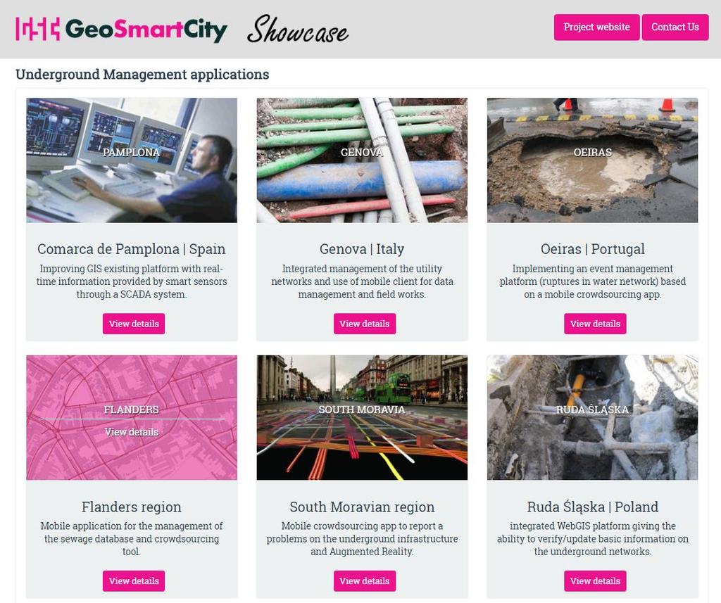
21 European households are responsible for 68% of the total final energy use in buildings, for: - heating (70%) - cooling - hot water - cooking - appliances The most used fuel is gas. source: 21

22 PILOTS GREEN ENERGY 22
23 5 pilot cities involved in this scenario - Reggio Emilia (Italy) - Maroussi (Greece) - Oeiras (Portugal) - Turku (Finland) - Girona (Spain) 13 Use Cases collected 61 requirements (functional, non-functional, generic) 23

24 Data will mainly regard: - Buildings (municipal, residential, ) - Transport (focus on bike) Buildings and transport represent GHG emission sources. All five pilot cities are indeed signatories of the Covenant of Mayors and need to: - monitor GHG emission sources - provide information to stakeholders 24

25 Use cases Reggio Emilia (Italy) Publication of energy performance and consumption of municipal buildings Publication of energy performance of other buildings General objectives Integrate geodata and energy data for strategic purposes Provide integrated open geodata Main requirements Estimate energy performance and CO2 emissions Energy maps and reports, interoperable access to data 25
26 Use cases Maroussi (Greece) Data collection via field survey and crowdsourcing Energy map creation Data publication General objectives Enable citizens and SMEs to make valuable comments and enhance their energy consumption behavior Main requirements Mobile app for editing buildings properties Searching capabilities for buildings Provide open geodata through the hub 26
27 Oeiras (Portugal) Use cases Urban sustainable planning tool Zero-balance calculation Calculation of energy performance of buildings General objectives Monitor energy consumption in public buildings Achieve a balance between various urban areas Main requirements Calculate solar potential and electric balance Reports, statistics 27
28 Turku (Finland) Use cases Selecting green route Green driving Green parking General objectives Shift from private to public transportation in commuter traffic Acquire real-life information that can be utilized in city planning and decision making Main requirements Bike routing, bus timetables, paths for commuters Estimation of fuel consumption, collect stats 28
29 Girona (Spain) Use cases I want to ride my bicycle, I want to ride it where I like Find healthy bike route General objectives Encourage alternative/light transportation Involve city users and stakeholders in data integration Main requirements Provide updates to OpenStreetMap Estimate pollution, calculate bike routing 29

30 Underground Scenario 30 30

 Environmental impact infrastructure Safety")
31 Underground Context Different infrastructure under the same area Unconnected information for the management of assets and systems (damages during maintenance activities) Environmental impact infrastructure Safety and security 31
 The citizen involvement (crowdsourcing mobile")
32 UNDERGROUND SCENARIO Status 6 pilot sites in EU 12 Use cases 61 User/System Requirements Commonalities The improvement of the efficiency of the underground network management (mainly in terms of integration of resources from different actors) The citizen involvement (crowdsourcing mobile apps) 32
33 PILOTS UNDERGROUND 33

34 Use cases: Consulting real-time data of the water supply and sanitation systems in a GIS viewer. Check smart sensor values or incidents in networks General Objectives: They want to improve the water and sewage GIS existing platform: Integrating real-time information provided by smart sensors through a SCADA system (a computer system for gathering and analyzing real time data) Consult a map with values from sensors or incidents from SCADA Main requirements: Pamplona (Spain) The SCADA system should be linked to the GIS through standardized protocols An interface should enable the user to communicate with the SCADA system to consult the real-time data The platform should enable the user to generate thematic maps (geoprocessing) 34
 Include INSPIRE compliant data in the city underground data management workflow (Harmonisation of gas, water and sewer datasets) Use of")
35 Genova (Italy) Use cases: Underground Cadastre Excavation procedure Field works Underground networks and environmental hazards General Objectives: Integrate different underground information layers from different actors (mainly Municipality and Multi-utilities) Include INSPIRE compliant data in the city underground data management workflow (Harmonisation of gas, water and sewer datasets) Use of mobile client for data management Use of advanced visualization techniques such as Augmented Reality Use of a high precision positioning (GNSS) device integrated with mobile client for field works Intersection between Underground Network and Environmental Hazard information 35

36 Use cases: Underground Event Management General Objectives: Main requirements: Oeiras (Portugal) As in the case of the Oeiras Pilot in the Green Energy scenario, the Municipality wants to implement an event management platform. This platform will take shape in a mobile crowdsourcing app for characterization and location of ruptures in water network. The System shall serve as a Metadata and Open Data provider through Web Services (WMS, WCS,...). An authenticated user must approve the crowdsourcing inputs to appear on the map. The web client should ensure different authentication levels depending on user roles. Open data: All information must be available to be used by applications from other stakeholders. 36

37 Flanders Region (Belgium) Use cases: Mobile application for the management of the sewage database Crowd-sourcing tool General Objectives: Focus on the conformance of the Flanders sewer network data to INSPIRE specifications Manage sewage network from a mobile/web client application Integrate in the system a crowdsourcing component so the sewage database can be consulted by the public in order to report possible anomalies or remarks. Main requirements: The application must give the opportunity to professionals to enter data, upload different files and to propose changes to geodata. The updates (by the users) are live but will only be implemented in the sewage database after validation. 37

38 South Moravian Region (CZ) Use cases: Mobile application General Objectives: Focus the provision or volunteered geographic information (VGI) trough a mobile app to report a problems on the public underground infrastructure. Use of mobile clients by municipalities and companies technicians (equipped with innovative visualization features such as Augmented Reality) to support the management and update of existing data on the field. Main requirements: Take a picture, determine local position, user comment and send it to appropriate service. Read data from dedicated WFS and display them in AR environment. 38

39 Ruda Śląska (Poland) Use cases: An integrated WebGIS platform giving the ability to verify/update basic information on the underground networks and to share the data in order to clarify the ownership issues. General Objectives: Similar to the Genova case, this pilot also focuses on the integration and harmonization of the underground network data coming from the municipality and the Utility companies. Data and specialized services will be integrated in existing GIS platform supporting an integrated approach on the management and maintenance of the networks. Main requirements: Mobile and web clients Authenticated access to information and permission roles 39
40 The GeoSmartCity Hub 40
41 The challenge of European Data Infrastructures INSPIRE PSI Projects Projects Country Country Country Region Region Region Municipality Municipality Municipality 41
42 The challenge of European Data Infrastructures INSPIRE PSI Projects Projects Country Country Country Region Region Region Municipality Municipality Municipality 42
43 Increasing amount of work The challenge of European Data Infrastructures INSPIRE PSI Projects Projects Country Country Country Region Region Region Municipality Municipality Municipality 43
44 Increasing amount of work Increasing amount of resources The challenge of European Data Infrastructures INSPIRE PSI Projects Projects Country Country Country Region Region Region Municipality Municipality Municipality 44


 Country Region Region")
45 Increasing amount of work Increasing amount of resources The challenge of European Data Infrastructures INSPIRE PSI Projects Country CS-W, WMS, WFS, INSPIRE data models Country Projects Linked Data, RDF, CSV(!) Country Region Region Region Municipality Municipality Municipality 45
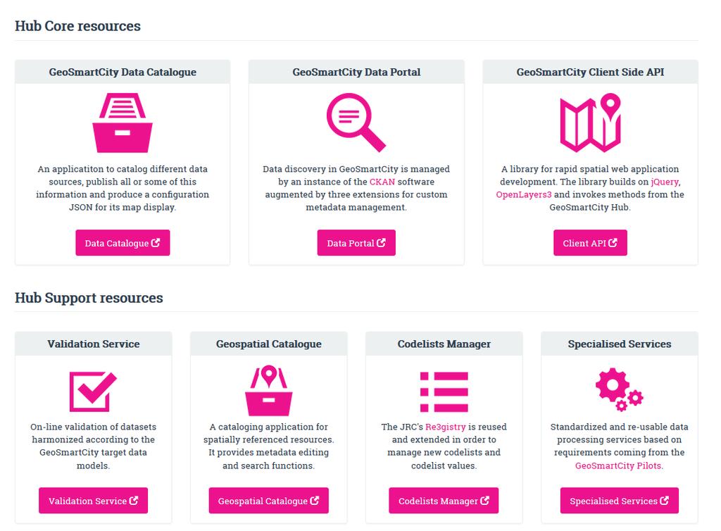
46 The Hub concept GeoSmartCity Hub is a software and hardware platform to catalogue, store, and make data available through web APIs. The server software components expose interfaces for integrating, visualizing, analyzing and processing spatial and non-spatial data sources, allowing users to upload or connect their data sources, configure map visualizations and publish data through a web based user interface. 46
47 Components in «the Hub» The pieces that make up the puzzle 47
48 Components The open data hub is based on CKAN and other open source solutions, connected to View and Download Services provided GeoServer and enhanced by specialized pilot-driven geoprocessing services. 48
49 49
50 50
51 Components 51
52 Manage data sources 52
53 Create/edit data sources 53
54 Manage data sets 54
55 Create/edit data set 55
56 Edit field aliases 56
57 Manage layer 57
58 Create/edit/publish layers 58
59 Components 59
")
60 Components (Data Portal) 60

61 The importance of being harmonized 61
62 The importance of being harmonized Generic workflow to transform datasets according to selected target schema requirements Import target/source schemas Import data Set mapping rules Export transformed data Validate transformed dataset 62
63 Components 63

64 JavaScript (a professional platform) Gsc.js: spatial «Lego» for rapid application development 64
65 Components (Validation Service) 65
66 Components (Validation Service) Extended from eenvplus project 66
67 Components (Geospatial Catalogue) 67

68 A cataloging application for spatially referenced resources. It provides metadata editing and search functions for all the Pilots 68

69 Components (Codelist Registry) 69
70 The importance of being Registered 70
71 Components (Specialized Services) 71
72 Underground domain Sense Operate Analyze Optimize Integrate SCADA data streaming SCADA configuration and programming Analysis Model and Predict Business models Geo Crowd Sensing Network monitoring Reporting Act External data sources Assets management GIS management Field Works 72
73 Underground specialized services / 1 Geo crowd-sensing client Geo crowd-sensing mobile client Geo crowd-sensing platform management Field work verification and correction Creation and sharing of personalized maps Field work orientation through augmentedreality 73
74 Underground specialized services / 2 Analysis of interaction between hazards and underground networks Tracing of sewage network Use of GIS and SCADA information GIS access to Sensor data streaming services 74


75 Green Energy domain Editing Deriving Routing Presenting Bdgs properties EPB Multilingual Geocoding Dashboard Bulk uploads (new bdgs) CO2 CO2 emitted Report OSM alignement Solar potential Drive to park CO2 monitored 75
76 Green Energy specialized services / 1 Buildings "on-site" data quality check Estimation of Energy Performance of buildings Buildings CO2 emissions estimation Heat consumption dashboard Green Energy report Upload of "future "buildings datasets Solar potential calculation Zero-balance layer 76
77 Green Energy specialized services / 2 Multi-lingual Address Geocoding Green preferences and routing Next departure time Drive to park 77
78 See more in the next presentations The GSC extended data models and the data harmonisation methodology - The Pilot in Ruda Śląska - The GeoSmartCity Training Framework Smart cities in Poland Adam Iwaniak Wroclaw University of Environmental and Life Sciences - Robert Olszewski Warsaw University of Technology - Paweł Sikora - Silesian University of Technology 78
79 GeoSmartCity Network The final outcome of GeoSmartCity is a long-term sustainable open network of stakeholders. All the interested stakeholders are very welcome to join the GeoSmartCity Community. Adhesion to the GeoSmartCity Network You will receive an inviation 79
GeoSmartCity open geo data for innovative services and user applications towards Smart Cities
 GeoSmartCity open geo data for innovative services and user applications towards Smart Cities CIP ICT PSP Project n. 621150 Start date 01 03 2014, duration 36 months 1 Open geo data for innovative services
GeoSmartCity open geo data for innovative services and user applications towards Smart Cities
 GeoSmartCity open geo data for innovative services and user applications towards Smart Cities CIP ICT PSP Project n. 621150 Start date 01 03 2014, duration 36 months 1 Objectives of the Association Geographical
GeoSmartCity Workshop Katowice October 26 th 2016
 1 GeoSmartCity Workshop Katowice October 26 th 2016 The GSC extended data models and the data harmonisation methodology Fabio Vinci, Giacomo Martirano, Stefania Morrone f.vinci@epsilon-italia.it, g.martirano@epsilon-italia.it,
Training Framework LINKVIT
 Geographical Infomation Systems International Group Training Framework LINKVIT G. Saio GISIG g.saio@gisig.it 1 www.linkvit.eu Project aims 2 LINKVIT deals with Digital Competence as defined in the Key
Exploitation towards Thematic Communities, Training Framework and stakeholders involvement
 Exploitation towards Thematic Communities, Training Framework and stakeholders involvement Giorgio Saio GISIG eenvplus Workshop INSPIRE Conference, Florence (IT), 24 June 2013 Exploitation prospects eenvplus
CREATING SMART TRANSPORT SERVICES BY FACILITATING THE RE-USE OF OPEN GIS DATA
 OPEN TRANSPORT NET TOMAS MILDORF 16 JUNE 2014 INSPIRE CONFERENCE 2014, AALBORG, DENMARK CREATING SMART TRANSPORT SERVICES BY FACILITATING THE RE-USE OF OPEN GIS DATA 2 1 OTN AT A GLANCE Full title OpenTransportNet
INSPIRE & Environment Data in the EU
 INSPIRE & Environment Data in the EU Andrea Perego Research Data infrastructures for Environmental related Societal Challenges Workshop @ pre-rda P6 Workshops, Paris 22 September 2015 INSPIRE in a nutshell
European Location Framework (ELF) acting as a facilitator implementing INSPIRE
 acting as a facilitator implementing INSPIRE") www.eurogeographics.org European Location Framework (ELF) acting as a facilitator implementing INSPIRE Saulius Urbanas, Mick Cory (EuroGeographics) 29 October 2016 Copyright 2013 EuroGeographics EuroGeographics
www.eurogeographics.org European Location Framework (ELF) acting as a facilitator implementing INSPIRE Saulius Urbanas, Mick Cory (EuroGeographics) 29 October 2016 Copyright 2013 EuroGeographics EuroGeographics
HUMBOLDT Application Scenario: Protected Areas
 CC by Erlend Schei Copyright by Kecko Copyright by Michael Bezzina CC by Gunnar Ries Copyright by Michael Bezzina Copyright by Michael Bezzina Copyright by Michael Bezzina CC by fs999 CC by Jordan Nielsen
THE ENVIRONMENTAL OBSERVATION WEB AND ITS SERVICE APPLICATIONS WITHIN THE FUTURE INTERNET Project introduction and technical foundations (I)
") ENVIROfying the Future Internet THE ENVIRONMENTAL OBSERVATION WEB AND ITS SERVICE APPLICATIONS WITHIN THE FUTURE INTERNET Project introduction and technical foundations (I) INSPIRE Conference Firenze,
ENVIROfying the Future Internet THE ENVIRONMENTAL OBSERVATION WEB AND ITS SERVICE APPLICATIONS WITHIN THE FUTURE INTERNET Project introduction and technical foundations (I) INSPIRE Conference Firenze,
Enhancing resilience of communities and territories through smart technologies. A SunShine perspective
 All truths are easy to understand once they are discovered; the point is to discover them. Enhancing resilience of communities and territories through smart technologies. A SunShine perspective Dr. Eng.
INSPIRE overview and possible applications for IED and E-PRTR e- Reporting Alexander Kotsev
 INSPIRE overview and possible applications for IED and E-PRTR e- Reporting Alexander Kotsev www.jrc.ec.europa.eu Serving society Stimulating innovation Supporting legislation The European data puzzle 24
Building the Future. New ICT Enables Smart Cities. Yannis Liapis Oct 25 th,
 Building the Future New ICT Enables Smart Cities Yannis Liapis Oct 25 th, 2017 1 Why Do We Need Smart City? Rapid population growth, urbanization acceleration Major issues Global population growth will
The enabling role of geospatial information in the European energy policies
 The European Commission s science and knowledge service Joint Research Centre The enabling role of geospatial information in the European energy policies Francesco Pignatelli Kehl (DE), 5 September 2017
Web apps for INSPIRE: the ELISE Energy pilot example
 Web apps for INSPIRE: the ELISE Energy pilot example 6 September 2017 Authors: Daniele Francioli Giacomo Martirano Maria Teresa Borzacchiello Francesco Pignatelli Outline Overview of the ELISE Energy Pilot
Strategic Transport Research and Innovation Agenda - STRIA
 Strategic Transport Research and Innovation Agenda - STRIA Brussels, 15 September 2016 Cristina Marolda DG Mobility & Transport European Commission Mobility & Transport Why do we need a new transport R&I
Evolution of INSPIRE interoperability solutions for e-government
 Evolution of INSPIRE interoperability solutions for e-government INSPIRE Implementation State-of-Play 26/05/2015 Robin S. Smith www.jrc.ec.europa.eu Serving society Stimulating innovation Supporting legislation
ELF- joining Europe together
 ELF- joining Europe together An open standard based multinational web mapping project, building on INSPIRE Presentation to: ISO/TC211 Standards in Action Workshop By: Date: Jari Reini 10 th June 2015 19
ELFI: A European Location Framework
 1 ELFI: A European Location Framework 1. Our Ambition Project ELFI will foster the wider use of geo-information and enable the creation of innovative valueadded services. 2. Our Objectives We aim to create
The Future of Solid State Lighting in Europe
 PLUS Conference "LED Lighting Strategies for Urban Spaces", 20/6/2012 The Future of Solid State Lighting in Europe Michael Ziegler European Commission DG Information Society and Media [-> DG CONNECT -
Making Open Data work for Europe
 Making Open Data work for Europe Daniele Rizzi European Commission DG Communications Networks, Content and Technology daniele.rizzi@ec.europa.eu Nikolaos Loutas PwC EU Services nikolaos.loutas@be.pwc.com
Semantic Interoperability of Basic Data in the Italian Public Sector Giorgia Lodi
 Semantic Interoperability of Basic Data in the Italian Public Sector Giorgia Lodi SEMIC conference 2013 21 June 2013 Dublin (AgID) Created last year, AgID is a public body that merged three different existing
Compass INSPIRE Services. Compass INSPIRE Services. White Paper Compass Informatics Limited Block 8, Blackrock Business
 Compass INSPIRE Services White Paper 2010 Compass INSPIRE Services Compass Informatics Limited Block 8, Blackrock Business Park, Carysfort Avenue, Blackrock, County Dublin, Ireland Contact Us: +353 1 2104580
Jan Bojko Czech Center for Science and Society
 Jan Bojko Czech Center for Science and Society Tomas Mildorf New technologies for the information society University of west bohemia in pilsen, Czech republic Karel Charvat Help Service Remote Sensing,
INSPIRE status report
 INSPIRE Team INSPIRE Status report 29/10/2010 Page 1 of 7 INSPIRE status report Table of contents 1 INTRODUCTION... 1 2 INSPIRE STATUS... 2 2.1 BACKGROUND AND RATIONAL... 2 2.2 STAKEHOLDER PARTICIPATION...
GENeric European Sustainable Information Space for Environment.
 GENeric European Sustainable Information Space for Environment http://www.genesis-fp7.eu/ Outline Introduction The GENESIS FP7 project The GENESIS solution s architecture GENESIS experience with INSPIRE
Interoperability and transparency The European context
 JOINING UP GOVERNMENTS EUROPEAN COMMISSION Interoperability and transparency The European context ITAPA 2011, Bratislava Francisco García Morán Director General for Informatics Background 2 3 Every European
Intelligent Urban Mobility Management System of Thessaloniki A common effort of the city s stakeholders
 Intelligent Urban Mobility Management System of Thessaloniki A common effort of the city s stakeholders Evangelos Mitsakis, CERTH-HIT September 10, 2012 Project data Funding 50% European Economic Area
INSPIRE and Open Data Recent Developments and Best Practices
 INSPIRE and Open Data Recent Developments and Best Practices These documents are only complete, when used in connection with the verbal paper; any isolated use may lead to misunderstandings. Michael Müller
DG CONNECT (Unit H5) Update on Data Centre Activities
 Update on Data Centre Activities") DG CONNECT (Unit H5) Update on Data Centre Activities Svetoslav Mihaylov Scientific/Technical Project Officer Smart Cities and Sustainability Directorate-General Communications Networks, Content and Technology
DG CONNECT (Unit H5) Update on Data Centre Activities Svetoslav Mihaylov Scientific/Technical Project Officer Smart Cities and Sustainability Directorate-General Communications Networks, Content and Technology
Toward Horizon 2020: INSPIRE, PSI and other EU policies on data sharing and standardization
 Toward Horizon 2020: INSPIRE, PSI and other EU policies on data sharing and standardization www.jrc.ec.europa.eu Serving society Stimulating innovation Supporting legislation The Mission of the Joint Research
geobrowser3d.com The Power of 3D GIS Tools in your Browser
 geobrowser3d.com 1 The Power of 3D GIS Tools in your Browser Overview Introduction Modules Success Stories Build your own What is GeoBrowser3D Interactive 3D visualization system Modular platform OGC compliant
Construction sector / ICT / Linked Data
 Construction sector / ICT / Linked Data Key pillars for data integration in smart buildings and cities 10/12/2015 Bruno Fiès CSTB / Information Technologies Department The Scientific & Technical Center
DT-ICT : Big data solutions for energy
 DT-ICT-11-2019: Big data solutions for energy info day Stefano Bertolo, DG CONNECT Mario Dionisio, DG ENER Scientific Programme Officers Who we are DG CONNECT, Unit G1 Data Policy and Innovation DG ENERGY,
GATE: Big Data for Smart Society Dessislava Petrova-Antonova Sofia University St. Kliment Ohridski Faculty of Mathematics and Informatics
 GATE: Big Data for Smart Society Dessislava Petrova-Antonova Sofia University St. Kliment Ohridski Faculty of Mathematics and Informatics Johann Wolfgang von Goethe Big Data provides the pipes, and AI
The European Commission s science and knowledge service. Joint Research Centre
 The European Commission s science and knowledge service Joint Research Centre GeoDCAT-AP The story so far Andrea Perego, Antonio Rotundo, Lieven Raes GeoDCAT-AP Webinar 6 June 2018 What is GeoDCAT-AP Geospatial
Introduction to INSPIRE. Network Services
 Introduction to INSPIRE. Network Services European Commission Joint Research Centre Institute for Environment and Sustainability Digital Earth and Reference Data Unit www.jrc.ec.europa.eu Serving society
Digital Platforms for 'Interoperable and smart homes and grids'
 25 October 2017, Brussels Digital Platforms for 'Interoperable and smart homes and grids' Focus Area "Digitising and Transforming European Industry and Services by Svet Mihaylov DG CONNECT WP 2018-2020
INSPIRE relevant policy developments in the EU's digital economy initiatives
 INSPIRE relevant policy developments in the EU's digital economy initiatives Interoperability Solutions and common Frameworks for European public Administrations, businesses and citizens as a means of
Integrating the UK Location Information Infrastructure and data.gov.uk
 Integrating the UK Location Information Infrastructure and data.gov.uk Rod Kedge - UK Location Programme 1 July 20011 This presentation The issue: How to derive the benefits of INSPIRE Background UKLII
European Address Forum Workshop INSPIRE Conference. Krakow, 22th June 2010
 Workshop INSPIRE Conference Krakow, 22th June 2010 Workshop Agenda Demonstration of Gazetteer Olaf Ostensen Practical Use of Addresses Stefan Sandmann EURADIN results Ivano Gauna María Cabello Demonstration
B2T Presentation and selection of projects. May, 2017
 B2T Presentation and selection of projects May, 2017 Key questions : When local authorities become smart - Smart city? Smart in the city? - Business model? - What exists today? vs city of the future FOR
WORLD TELECOMMUNICATION STANDARDIZATION ASSEMBLY Hammamet, 25 October 3 November 2016
 I n t e r n a t i o n a l T e l e c o m m u n i c a t i o n U n i o n ITU-T TELECOMMUNICATION STANDARDIZATION SECTOR OF ITU WORLD TELECOMMUNICATION STANDARDIZATION ASSEMBLY Hammamet, 25 October 3 November
INSPIRE in a nutshell, and overview of the European Union Location Framework
 INSPIRE in a nutshell, and overview of the European Union Location Framework Francesco Pignatelli European Commission, DG JRC 10 th European Congress and Exhibition on Intelligent Transport Systems and
Module 2: Rise of Urbanization & Digital Technologies
 Digital Cities Summit Oct 3-4, 2016 Module 2: Rise of Urbanization & Digital Technologies Day 1 Hong Kong a very densely populated city 7.3 million population and 1,110 km 2 land area Land composition:
Big Data Value cppp Big Data Value Association Big Data Value ecosystem
 Big Data Value cppp Big Data Value Association Big Data Value ecosystem Laure Le Bars, SAP, BDVA President and BDVe lead Nuria de Lama, ATOS, BDVA Deputy Secretary General, BDVe co-lead Ana García Robles,
Open Smart City Open Social Innovation Infrastructure. Cezary Mazurek, Maciej Stroinski Poznan Supercomputing and Networking Center
 Open Smart City Open Social Innovation Infrastructure Cezary Mazurek, Maciej Stroinski Poznan Supercomputing and Networking Center 25 years of PSNC Poznań Supercomputing and Networking Center (PSNC), established
SMARTATL. A Smart City Overview and Roadmap. Evanta CIO Executive Summit 1
 SMARTATL A Smart City Overview and Roadmap Evanta CIO Executive Summit 1 Southeast USA Overview Evanta CIO Executive Summit 2 Metro Atlanta Overview Evanta CIO Executive Summit 3 Permits, New Units under
Enterprise Geographic Information Servers. Dr David Maguire Director of Products Kevin Daugherty ESRI
 Enterprise Geographic Information Servers Dr David Maguire Director of Products Kevin Daugherty ESRI Outline Introduction Enterprise GIS vs. Spatially-enabled IS Architectures for building Enterprise GIS
Endesa s mass-scale metering roll-out
 endesa dirección acceso de clientes y medida 10 10 12 Endesa s mass-scale metering roll-out Dr. Robert Denda Smart Metering Project Coordinator Endesa s Smart Metering System 2011 2010 2009-2008 2018 2012
ICTPSP Call Theme 2 ICT for energy efficiency and sustainability in urban areas. Dr. Manuel SANCHEZ JIMENEZ
 ICTPSP Call 2008 Theme 2 ICT for energy efficiency and sustainability in urban areas Dr. Manuel SANCHEZ JIMENEZ European Commission DG INFSO Unit H4 ICT for Sustainable Growth manuel.sanchez-jimenez@ec.europa.eu
Proposition to participate in the International non-for-profit Industry Association: Energy Efficient Buildings
 Proposition to participate in the International non-for-profit Industry Association: Energy Efficient Buildings Working towards the launch of an EU Joint Technology Initiative on Energy Efficient Buildings
This document is a preview generated by EVS
 TECHNICAL REPORT RAPPORT TECHNIQUE TECHNISCHER BERICHT CEN/TR 15449-5 April 2015 ICS 07.040; 35.240.70 English Version Geographic information - Spatial data infrastructures - Part 5: Validation and testing
SLIPO. Scalable Linking and Integration of Big POI data. Giorgos Giannopoulos IMIS/Athena RC
 SLIPO Scalable Linking and Integration of Big POI data I n f o r m a ti o n a n d N e t w o r ki n g D a y s o n H o ri z o n 2 0 2 0 B i g Da ta Public-Priva te Partnership To p i c : I C T 14 B i g D
What is coming in. ArcGIS Server 10. Ismael Chivite ArcGIS Server Product Manager James Cardona Technical Marketing
 What is coming in ArcGIS Server 10 Ismael Chivite ArcGIS Server Product Manager James Cardona Technical Marketing ArcGIS Server is a complete server based GIS Delivering GIS with powerful services and
Sviluppi e priorità europee nel settore delle smart grids. M. de Nigris
 Sviluppi e priorità europee nel settore delle smart grids M. de Nigris DRIVERS FOR AN ENERGY (R)EVOLUTION IN EUROPE INCREASING ENERGY BILL EUROPEAN ENERGY BILL FOR IMPORT: 1 b /DAY VOLATILITY OF ENERGY
Italy - Information Day: 2012 FP7 Space WP and 5th Call. Peter Breger Space Research and Development Unit
 Italy - Information Day: 2012 FP7 Space WP and 5th Call Peter Breger Space Research and Development Unit Content Overview General features Activity 9.1 Space based applications and GMES Activity 9.2 Strengthening
Data as a Key Enabler For Future Mobility Opportunities for the Region and Roles Of Governments
 Data as a Key Enabler For Future Mobility Opportunities for the Region and Roles Of Governments Dr Stephane Dreher Transport Data and Statistics Advisor United Nations Development Programme Ministry of
Networking for Sustainability & Green Digital Charter
 Networking for Sustainability & Green Digital Charter Nikolaos Kontinakis, EUROCITIES Project coordinator nikolaos.kontinakis@eurocities.eu Sustainability is in our hands global networking 14 May 2014,
SAFER the GIGAS Effect
 SAFER the GIGAS Effect How INSPIRE, GMES and GEOSS are influencing EC projects Arnaud Cauchy 23/06/2010 Agenda GIGAS Project Summary SAFER Project Summary SAFER Original Approach GIGAS Influences SAFER
EC (DG SANTE) The ehealth DSI , Solution Provider
 The ehealth DSI , Solution Provider") EC (DG SANTE) The ehealth DSI 2017-04-05, Solution Provider Materials prepared by the ehdsi Solution Provider Topics tackled 1. CEF ehealth DSI (ehdsi) 2. Use Cases: Patient Summary and eprescription 3.
EC (DG SANTE) The ehealth DSI 2017-04-05, Solution Provider Materials prepared by the ehdsi Solution Provider Topics tackled 1. CEF ehealth DSI (ehdsi) 2. Use Cases: Patient Summary and eprescription 3.
Webservice-energy.org GEO Community Portal & Spatial Data Infrastructure for Energy
 Webservice-energy.org GEO Community Portal & Spatial Data Infrastructure for Energy Lionel Menard / Oct. 23 2017 Centre Observation, Impacts, Energy Research activities: Use of Earth observation data (Models,
Summary. Strategy at EU Level: Digital Agenda for Europe (DAE) What; Why; How ehealth and Digital Agenda. What s next. Key actions
 What; Why; How ehealth and Digital Agenda. What s next. Key actions") Summary Strategy at EU Level: Digital Agenda for Europe (DAE) What; Why; How ehealth and Digital Agenda Key actions What s next What DAE - EC Communication, adopted in May 2010 Flagship Initiative of EU
Summary Strategy at EU Level: Digital Agenda for Europe (DAE) What; Why; How ehealth and Digital Agenda Key actions What s next What DAE - EC Communication, adopted in May 2010 Flagship Initiative of EU
How to Create a European INSPIRE Compliant Data Specification. Anja Hopfstock, BKG (Germany) Morten Borrebæk, SK (Norway)
 Morten Borrebæk, SK (Norway)") How to Create a European INSPIRE Compliant Data Specification Anja Hopfstock, BKG (Germany) Morten Borrebæk, SK (Norway) ESDIN Key Goals Further the ambition of the European Commission to create a European
How to Create a European INSPIRE Compliant Data Specification Anja Hopfstock, BKG (Germany) Morten Borrebæk, SK (Norway) ESDIN Key Goals Further the ambition of the European Commission to create a European
Optimizing Field Operations. Jeff Shaner
 Optimizing Field Operations Jeff Shaner Field GIS Taking GIS Beyond the Office Collecting Data Reporting Observations Managing Work Connecting the Field with the Enterprise Workforce for ArcGIS Field workforce
PROJECT FINAL REPORT. Tel: Fax:
 PROJECT FINAL REPORT Grant Agreement number: 262023 Project acronym: EURO-BIOIMAGING Project title: Euro- BioImaging - Research infrastructure for imaging technologies in biological and biomedical sciences
Paper ID TP0972. ICT Infrastructure-based cooperative and connected systems for intelligent European road transport
 12 th ITS European Congress, Strasbourg, France, 19-22 June 2017 Paper ID TP0972 ICT Infrastructure-based cooperative and connected systems for intelligent European road transport Meng Lu 1*, Robbin Blokpoel
TOOP Introducing The Once-Only Principle project
 TOOP Introducing The Once-Only Principle project Digital Transport and Logistics Forum 5 th Plenary Meeting Robert Krimmer / 26 April 2017 / Brussels 1 Aim Explore and demonstrate the once-only principle
Hybrid Communication. CODECS Workshop / May 19, 2017 Karsten Roscher, Fraunhofer ESK Enrique Onieva, Deusto
 Hybrid Communication CODECS Workshop / May 19, 2017 Karsten Roscher, Fraunhofer ESK Enrique Onieva, Deusto Contents Project Overview Hybrid Communication Concepts Services Enabled by Hybrid Communication
Call for Participation in AIP-6
 Call for Participation in AIP-6 GEOSS Architecture Implementation Pilot (AIP) Issue Date of CFP: 9 February 2013 Due Date for CFP Responses: 15 March 2013 Introduction GEOSS Architecture Implementation
DELIVERABLE. D3.9 TransformingTransport Open Data Portal
 DELIVERABLE D3.9 TransformingTransport Open Data Portal Project Acronym TT Project Title Transforming Transport Grant Agreement number 731932 Call and topic identifier ICT-15-2016 Funding Scheme Innovation
SEIS. (Shared Environmental Information System) From concept to information services
 From concept to information services") SEIS (Shared Environmental Information System) From concept to information services Stefan Jensen EEA supported by Sheila Cryan and Jon Maidens GSDI 11, Rotterdam 19.6.2009 What is SEIS is about... Sharing
SEIS (Shared Environmental Information System) From concept to information services Stefan Jensen EEA supported by Sheila Cryan and Jon Maidens GSDI 11, Rotterdam 19.6.2009 What is SEIS is about... Sharing
Energy Management Smart to Smarter
 Energy Management Smart to Smarter Ian Lee Solution Director 23 rd September 2015 We are focused on energy management. We make energy safe, reliable, efficient, productive and green to manage, control
GRID MODERNIZATION INITIATIVE PEER REVIEW
 GRID MODERNIZATION INITIATIVE PEER REVIEW GMLC 1.3.5 DER Siting and Optimization tool for JOHN GROSH & GONÇALO CARDOSO April 18-20, 2017 Sheraton Pentagon City Arlington, VA Planning and Design Tools 4/4/17
SPACE for SDGs a Global Partnership
 SPACE for SDGs a Global Partnership for the Coordination of the Development, Operation and Utilization of Space related Infrastructure, Data, Information and Services in support of the 2030 Development
European Transport Policy: ITS in action ITS Action Plan Directive 2010/40/EU
 European Transport Policy: ITS in action ITS Action Plan Directive 2010/40/EU Hermann Meyer, CEO ERTICO IMPACTS, Barcelona, 31 March 2011 This presentation is mainly based on charts which were already
A SMART PORT CITY IN THE INTERNET OF EVERYTHING (IOE) ERA VERNON THAVER, CTO, CISCO SYSTEMS SOUTH AFRICA
 ERA VERNON THAVER, CTO, CISCO SYSTEMS SOUTH AFRICA") A SMART PORT CITY IN THE INTERNET OF EVERYTHING (IOE) ERA VERNON THAVER, CTO, CISCO SYSTEMS SOUTH AFRICA Who is Cisco? Convergence of Mobile, Social, Cloud, and Data Is Driving Digital Disruption Digital
A SMART PORT CITY IN THE INTERNET OF EVERYTHING (IOE) ERA VERNON THAVER, CTO, CISCO SYSTEMS SOUTH AFRICA Who is Cisco? Convergence of Mobile, Social, Cloud, and Data Is Driving Digital Disruption Digital
The EU's take on ICT for Sustainability in the context of Smart cities
 The EU's take on ICT for Sustainability in the context of Smart cities Svetoslav Mihaylov Smart Cities and Sustainability Directorate-General Communications Networks, Content and Technology European Commission
GeoDCAT-AP Representing geographic metadata by using the "DCAT application profile for data portals in Europe"
 GeoDCAT-AP Representing geographic metadata by using the "DCAT application profile for data portals in Europe" Andrea Perego, Vlado Cetl, Anders Friis-Christensen, Michael Lutz, Lorena Hernandez Joint
e-sens Nordic & Baltic Area Meeting Stockholm April 23rd 2013
 e-sens Nordic & Baltic Area Meeting Stockholm April 23rd 2013 Objectives of the afternoon parallel tracks sessions 2 Meeting objectives High level: Identification of shared interests with emphasis on those
Experience of EurekaBuild: How to use the EUREKA programme to support the implementation of the Strategic Research Agenda
 EUREKA UMBRELLA PROJECT: Technologies for a Sustainable and Competitive Construction Sector Experience of EurekaBuild: How to use the EUREKA programme to support the implementation of the Strategic Research
Annual Report for the Utility Savings Initiative
 Report to the North Carolina General Assembly Annual Report for the Utility Savings Initiative July 1, 2016 June 30, 2017 NORTH CAROLINA DEPARTMENT OF ENVIRONMENTAL QUALITY http://portal.ncdenr.org Page
EU Technology Platform SmartGrids WG2 Network Operations
 EU Technology Platform SmartGrids WG2 Network Operations Tahir Kapetanovic Director Electricity, E-Control Member of the SmartGrids AC Chairman of the WG2 tahir.kapetanovic@e-control.at Overview SmartGrids
A Case Study about IFEZ(Song-do) Smart-City. Ryan LEE
 Smart-City. Ryan LEE") A Case Study about IFEZ(Song-do) Smart-City Ryan LEE Career History Incheon U-City Corporation Incheon, Korea - Director, IFEZ Smart-City Integrated Operation Center * Managing IFEZ Smart City Integrated
A Case Study about IFEZ(Song-do) Smart-City Ryan LEE Career History Incheon U-City Corporation Incheon, Korea - Director, IFEZ Smart-City Integrated Operation Center * Managing IFEZ Smart City Integrated
2017 SOCIÉTÉ GÉNÉRALE SRI CONFERENCE 07/11/17
 2017 SOCIÉTÉ GÉNÉRALE SRI CONFERENCE 07/11/17 DISCLAIMER SOCIÉTÉ GÉNÉRALE NOVEMBER 7, 2017 SRI CONFERENCE This document was prepared by Klépierre solely for use of 2017 Société Générale SRI Conference.
FP7-INFRASTRUCTURES Grant Agreement no Scoping Study for a pan-european Geological Data Infrastructure D 4.4
 FP7-INFRASTRUCTURES-2012-1 Grant Agreement no. 312845 Scoping Study for a pan-european Geological Data Infrastructure D 4.4 Report on recommendations for implementation of the EGDI Deliverable number D4.4
IoT as a Basic Ingredient of Smart Cities
 IoT as a Basic Ingredient of Smart Cities Cities as Platforms Thessaloniki, 13 November 2015 Nikos ISARIS, European Commission FIRE at a glance Supporting research and innovation on new network and service
Use case 1 INSPIRE harmonization of existing Energy Performance Certificate datasets Phase 1
 The European Commission s science and knowledge service Joint Research Centre Use case 1 INSPIRE harmonization of existing Energy Performance Certificate datasets Phase 1 Giacomo Martirano (external consultant)
Market monitoring and web frequentation note No. 1 (month 10)
") EURO-TOPTEN PLUS Extension and strengthening of the European Topten Inititiatives and of the market for innovative and efficient products Market monitoring and web frequentation note No. 1 (month 10) Deliverable
EURO-TOPTEN PLUS Extension and strengthening of the European Topten Inititiatives and of the market for innovative and efficient products Market monitoring and web frequentation note No. 1 (month 10) Deliverable
Fixed and wireless broadband mapping in Belgium
 Belgian Institute for Postal Services and Telecommunications Fixed and wireless broadband mapping in Belgium Broadband mapping Conference in Warsaw, Poland, 11-12 April, 2016 BIPT Agenda Objectives Roadmap
Innovative use of big data - Investing in the Danish smart city sector
 Innovative use of big data - Investing in the Danish smart city sector The liveable city, Glasgow November 10, 2016 Practical Examples of Danish Smart City and IOT Deployments Jeanette Carlsson, CEO newmedia2.0
An Overview of Smart Sustainable Cities and the Role of Information and Communication Technologies (ICTs)
") An Overview of Smart Sustainable Cities and the Role of Information and Communication Technologies (ICTs) Sekhar KONDEPUDI Ph.D. Vice Chair FG-SSC & Coordinator Working Group 1 ICT role and roadmap for
An Overview of Smart Sustainable Cities and the Role of Information and Communication Technologies (ICTs) Sekhar KONDEPUDI Ph.D. Vice Chair FG-SSC & Coordinator Working Group 1 ICT role and roadmap for
Rui Reis, Maria José Vale, Marcelo Ribeiro, Bruno Meneses Geospatial World Forum 2016, May 2016, Rotterdam
 LC change detection and planning indicators Rui Reis, Maria José Vale, Marcelo Ribeiro, Bruno Meneses Summary 1. 2. 3. 4. 5. 6. 7. 8. Introduction Pilot overview Data description Inspire data harmonization
DIGITIZING INDUSTRY, ICT STANDARDS TO
 DIGITIZING INDUSTRY, ICT STANDARDS TO DELIVER ON DIGITAL SINGLE MARKET OBJECTIVES ETSI When Standards Support Policy 14 November 2016 Emilio Davila Gonzalez Unit Start ups & Innovation, EC DG Connect 72%
Cisco Smart+Connected Communities
 Brochure Cisco Smart+Connected Communities Helping Cities on Their Digital Journey Cities worldwide are becoming digital or are evaluating strategies for doing so in order to make use of the unprecedented
ehaction Joint Action to Support the ehealth Network
 Stakeholder Engagement - Consultation (22 August 2017) ehaction Joint Action to Support the ehealth Network 3 rd Joint Action to Support the ehealth Network Open Consultation 1 Participants of the 3 rd
Bringing Singapore to life in 3D
 Bringing Singapore to life in 3D Dr Victor Khoo, Deputy Director Singapore Land Authority Bringing Singapore to life in 3D ESRI Singapore UC 2016 Dr. Victor Khoo Singapore Land Authority SLA 2016 RESTRICTED
KIC Added-value Manufacturing: Exploiting synergies and complementarities with EU policies and programmes
 KIC Added-value Manufacturing: Exploiting synergies and complementarities with EU policies and programmes EIT Infoday Brussels, 18 February 2016 Heidi Moens, DG GROW Neophytos Neophytou, DG RTD Francesca
esignature Infrastructure Marketing Model
 www.peppol.eu esignature Infrastructure Marketing Model esignature Long Demo Objectives of PEPPOL esignature The overall objective of PEPPOL esignature is to provide cross European interoperability of
National Data Sharing and Accessibility Policy-2012 (NDSAP-2012)
") National Data Sharing and Accessibility Policy-2012 (NDSAP-2012) Department of Science & Technology Ministry of science & Technology Government of India Government of India Ministry of Science & Technology
National Data Sharing and Accessibility Policy-2012 (NDSAP-2012) Department of Science & Technology Ministry of science & Technology Government of India Government of India Ministry of Science & Technology