South Mountain Freeway Interchange Selection
|
|
|
- Warren Alexander
- 5 years ago
- Views:
Transcription
1 slide 1 South Mountain Freeway Interchange Selection Public Private Partnership (P3)

2 Today s Agenda Project Overview Interchange Selection Pavement Selection Lawsuit Update Design and Construction Q&A
3 Loop 202 South Mountain Freeway 22 new miles 4.5 miles (I-10) 40 bridges 13 interchanges 1 double roundabout 2 half diverging diamond 11 miles noise walls 6 miles shared-use path 5 multi-use crossings 1 system interchange 1 pedestrian bridge
4 Interchange Selection

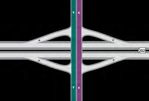


5 Interchanges
6 Location Design Concept Report Proposal Alternative Technical Concept Development Phase Broadway Rd Diamond - Fwy Over Diamond Fwy Under Diamond - Fwy Over Southern Diamond Fwy Over Diamond Fwy Under Diamond- Fwy Over Dobbins Rd Diamond Fwy Over Diamond Fwy Under Diamond Fwy Over 51 st Ave Spur/Estrella Diamond Fwy Over Diamond Fwy Over Roundabout Fwy Over - Moved to Estrella Dr. 17 th Avenue Diamond Fwy Over Diamond - Fwy Over DDI Fwy Over Desert Foothills Pkwy Diamond - Fwy Over Diamond Fwy Under DDI Fwy Under


7 I-10/SR202L System Interchange Pursuit Phase Alternative Technical Concept
8 I-10/SR202L System Interchange Pursuit Layout same as DCR ATC - NW departs on its own Better Driver Expectation- Right hand exits Similar - US60/I-10 System TI Lesser ROW Footprint


9 Broadway Rd Interchange Pursuit Phase Development Phase

10 Broadway Rd Interchange Fwy Under to Fwy Over City of Phoenix SHROG (2-96 Sewer Line) Protection Earthwork Eliminate Access Rds to Lower Buckeye Replace with Temp Ramps ADOT Directive Change

11 Southern Avenue Interchange Pursuit Phase Development Phase
12 Southern Avenue Interchange Freeway Under to Freeway Over Better Access to Country Gardens School Lesser Utility Impact

13 Dobbins Rd Interchange Pursuit Phase Development Phase
 Other future development considerations Utility Sleeves for future Historical site /")
14 Dobbins Rd Interchange Fwy under to Fwy Over SRPI/BOR land acquisition process Improved access to future hospital (NW quadrant) Other future development considerations Utility Sleeves for future Historical site / Goat Barn

15 Estrella Drive Interchange GRIC WELL Pursuit Phase Alternative Technical Concept
16 Estrella Drive Interchange Pursuit diamond 51 st Ave Spur at DCR location Alternative Technical Concept double round about Location shift to Estrella Avoidance of GRIC Well properties

17 17 th Avenue Interchange Pursuit Phase Alternative Technical Concept
18 17 th Avenue Interchange Pursuit Diamond Alternative Technical Concept Convert to ½-DDI Land acquisition residential housing development Connection to existing rdwy Signalization closely matches existing condition


19 Desert Foothills Parkway Interchange POST OFFICE Pursuit Phase Alternative Technical Phase
 Highest elevation on the")
20 Desert Foothills Interchange Crossroad Over Freeway slightly depressed Diamond to ½-DDI ROW avoidance (Post Office) Highest elevation on the project

21 Pavement Section
22 Subgrade Soils Lower Quality Higher Quality Higher Quality Develop based upon soil conditions Native vs. Borrow Earthwork flow constraints Where is the fill coming from? Farm Fields South Mountain Park area

23 Mainline-Ramp I-10 Mainline (Match Existing - Prescribed) 1 AR-ACFC 15 PCCP SR 202 Mainline AC ACFC ½ Depth AC - Varies 8-9 Depth AB Varies 13 ½ 14 ½ SR 202 Ramps AC AR-ACFC ½ Depth AC Varies 4-6 Depth AB Varies 8-12 Depth
24 Cross Roads Cross Roads PCCP 8-11 ½ Depth AC 2 ½ Depth Acceleration/Deceleration Truck Traffic High Volumes
25 Lawsuit 9 th Circuit Court Decision December 8, 2017 NTP 3 Timing February 7, 2018

26 Design / Construction Update Status
27 PROGRESS

28 Final Design Status Over 500 design submittals 7,500 plan sheets 125 RFC packages Final design schedule Pecos: All RFC ed I-10: All RFC ed Salt River: All RFC ed Center: RFC Summer 2018
29 60 BLASTS TO DATE
30 RECEIVED NOTICE TO PROCEED 3


31 8-MILES OF PIPE TO DATE
32 3.6 M CY OF DIRT MOVED TO DATE


33 I-10/SR202L System TI September 2016 February 2018


34 I-10/SR202L System TI September 2016 February 2018


35 Broadway Rd Interchange September 2016 February 2018


36 Salt River Bridge September 2016 February 2018


37 Salt River Bridge September 2016 February 2018


38 Southern Avenue Traffic Interchange September 2016 February 2018


39 Dobbins Rd Interchange September 2016 February 2018


40 Elliot Rd Interchange September 2016 February 2018


41 Estrella Drive Interchange September 2016 February 2018


42 17 th Avenue Interchange September 2016 February 2018


43 Desert Foothills Parkway September 2016 February 2018


44 24 th Street Traffic Interchange September 2016 February 2018


45 40 th Street Traffic Interchange September 2016 February 2018

46 INFORMATION Hotline: SMF-L202 ( ) Español: Website: Add COUNT DOWN CLOCK -----

47 QUESTIONS
10 CORPORATE CENTER SOUTH 51ST STREET, PHOENIX, AZ
 RENOVATIONS COMPLETE 2018 FOR LEASE 10 CORPORATE CENTER 10201-10235 SOUTH 51ST STREET, PHOENIX, AZ Building Size Bldg A 10201 S 51st St + 48,510 RSF 2-story Bldg B 10235 S 51st St + 25,282 RSF 1-story
THE SOUTHERN GATEWAY MANAGED LANES PROJECT. Public Meetings Summer 2015 June 23, June 25, July 7, July 9
 THE SOUTHERN GATEWAY MANAGED LANES PROJECT Public Meetings Summer 2015 June 23, June 25, July 7, July 9 History & Background Began in 2001 as a Major Investment Study (MIS), Schematic, and Environmental
Perimeter Parkview Corporate Center
 FOR LEASE Perimeter Parkview Corporate Center 8355 E Hartford Dr, Scottsdale 203RD A 103 3,559 Spec suite SUN VALLEY with PKWY large open-office area $25.00 SF BELL RD YUMA RD OLIVE AVE NORTHERN AVE INDIAN
NEWLY RENOVATED 1144 E. MCDOWELL RD., PHOENIX, AZ 85006
 MEDICAL E. MCDOWELL RD., PHOENIX, AZ 85006 BUILDING FEATURES NEWLY RENOVATED E. McDowell Rd. > Property Description RENOVATIONS COMPLETE! BUILDING SIZE: ±29,088 SF AVAILABILITY: BASEMENT/LAB: ±3,000 RSF
Perimeter Parkview Corporate Center
 FOR LEASE Perimeter Parkview Corporate Center 8355 E Hartford Dr, Scottsdale 203RD A 103 4,247 Former SUN ASU VALLEY Lecture PKWY space $25.00 FS BELL RD YUMA RD OLIVE AVE NORTHERN AVE INDIAN SCHOOL RD
10 CORPORATE CENTER SOUTH 51ST STREET, PHOENIX, AZ
 FOR LEASE SUITES FROM 1,161-5,349 SF 10 CORPORATE CENTER 10201-10235 SOUTH 51ST STREET, PHOENIX, AZ Building Size Bldg A 10201 S 51st St + 48,510 RSF 2-story Bldg B 10235 S 51st St + 25,282 RSF 1-story
NEWLY RENOVATED FOR SALE 1144 E. MCDOWELL RD., PHOENIX, AZ 85006
 MEDICAL E. MCDOWELL RD., PHOENIX, AZ 85006 BUILDING FEATURES FOR SALE NEWLY RENOVATED E. McDowell Rd. > Property Description RENOVATIONS COMPLETE! BUILDING SIZE: ±29,088 SF AVAILABILITY: BASEMENT LEVEL
STUDY REPORT #1 ADDENDUM
 STUDY REPORT #1 ADDENDUM 1.0 PURPOSE OF ADDENDUM This document is an addendum to Study Report #1: Sub-System Planning Alternatives. The purpose of this addendum is to bridge the gap between the initial
Dakota County Transportation CIP Process Requests from cities/townships
 City of Apple Valley Letter: e-mail w/traffic Engineer City of Apple Valley Engineer coordinating CIP Project County Traffic Staff is in the process of assessing Requests directly with Dakota County Traffic
PE Exam Review - Surveying Demonstration Problem Solutions
 PE Exam Review - Surveying Demonstration Problem Solutions I. Demonstration Problem Solutions... 1. Circular Curves Part A.... Circular Curves Part B... 9 3. Vertical Curves Part A... 18 4. Vertical Curves
NEWLY RENOVATED FOR LEASE 1144 E. MCDOWELL RD., PHOENIX, AZ 85006
 MEDICAL E. MCDOWELL RD., PHOENIX, AZ 85006 BUILDING FEATURES FOR LEASE NEWLY RENOVATED E. McDowell Rd. > Property Description RENOVATIONS COMPLETE! BUILDING SIZE: ±29,088 SF AVAILABILITY: BASEMENT/LAB:
Gaston County GIS. Interactive Mapping Website
 Gaston County GIS Interactive Mapping Website The Gaston County GIS mapping website optimizes the available window viewing area and has interactive tools, collapsible menus and movable windows. This map
Planning Partners Meeting
 January 10, 2011 Planning Partners Meeting All Rights Reserved, 2010 Find us at: Agenda Introductions & Project Update Project Outreach Update Buildout Socioeconomic Data (SED) Initial Buildout Modeling
2011 Congestion Management Program Update
 PPLC Meeting 06/13/11 Agenda Item 4A Handout 2011 Congestion Management Program Update Presentation to PPLC June 13, 2011 Slide 1 2011 CMP Update Status Update Schedules, Issues, approach approved January
SWLRT Community Advisory Committee Meeting. June 27, 2013
 SWLRT Community Advisory Committee Meeting June 27, 2013 Today s Topics Welcome and Introductions Hennepin County Works Update: TSAAP Open House Summary Mind-Mixer Demonstration Focus Group Outreach Technical
Environmental Impact Questionnaire
 Community Development Department 11 English Street Petaluma, CA 94952 Phone: 707-778-4301 Email: cdd@ci.petaluma.ca.us Web: www.cityofpetaluma.net/cdd Building Geographic Information Systems Housing Neighborhood
North Metro Corridor Draft Environmental Impact Statement (DEIS) Public Hearings. December 9 & 10, 2009
 Public Hearings. December 9 & 10, 2009") North Metro Corridor Draft Environmental Impact Statement (DEIS) Public Hearings December 9 & 10, 2009 1 Welcome & Introductions 2 3 What Are We Doing Here Tonight? Public Hearing for RTD North Metro Corridor
North Metro Corridor Draft Environmental Impact Statement (DEIS) Public Hearings December 9 & 10, 2009 1 Welcome & Introductions 2 3 What Are We Doing Here Tonight? Public Hearing for RTD North Metro Corridor
Northwest Needs Improvements Survey
 PW5 NW 107th Ave One thousand feet N of NW 122nd St Okeechobee Rd Widen bridge over Miami Canal PW6 NW 82nd Ave NW 8th St NW 12th St Construct new 4-lane road PW7 NW 87 Ave NW 36th St NW 58th St Add 2-lanes
APPENDIX E TRANSPORTATION
 APPENDIX E TRANSPORTATION 2011 PATRON SURVEYS VISSIM MODEL CALIBRATION AND VALIDATION Environmental and Planning Consultants 440 Park Avenue South 7th Floor New York, NY 10016 tel: 212 696-0670 fax:
Feasibility Study Downtown Moorhead Railroad Grade Separation Moorhead, Minnesota July 2008
 Feasibility Study Downtown Moorhead Railroad Grade Separation Moorhead, Minnesota July 2008 INTRODUCTION The City of Moorhead (City), along with the Fargo-Moorhead Metropolitan Council of Governments (FM
Study Area and Location District PSA Ward ANC Phase Description G Planned Connecticut Avenue Northbound at Military Road Northwest
 Speed Limit and Safety Nexus Studies for Automated Enforcement Locations in the District of Columbia Connecticut Avenue at Military Road NW Study Area and Location District PSA Ward ANC Phase Description
Kansas Division. January 31, 2018
 Division January 31, 6111 SW 29 th, Suite 100 Topeka, 66614 (785) 273-2600 (785) 273-2620 (fax) www.fhwa.dot.gov/ksdiv/index.htm Catherine M. Patrick, P.E. State Transportation Engineer Department of Transportation
FOR SALE BANK OWNED OFFICE CENTRAL LAKELAND HISTORIC DISTRICT
 Jack Strollo, Broker 500 S. Florida Avenue, Suite 420 Lakeland, Florida 33801 O. 863.683.3425 x103 C. 863.640.8238 jstrollo@resbroadway.com FOR SALE BANK OWNED OFFICE CENTRAL LAKELAND HISTORIC DISTRICT
Traffic Impact Study for the TAVA Homes Project at 1584 East Santa Clara Avenue in the City of Santa Ana
 Traffic Impact Study for the TAVA Homes Project at 1584 East Santa Clara Avenue in the City of Santa Ana March 2011 Prepared for: URS Corporation 2020 E. First Street, Suite #400 Santa Ana, CA 92705 Tel:
Ohio River Tunnel Update. July 11, 2017
 Ohio River Tunnel Update July 11, 2017 Agenda Introductions Getting to Know You Project Overview Ohio River Tunnel Projects Project Schedule Cost Estimate Keeping Each Other Informed Feedback Getting to
INVESTMENT SALE. Industrial Warehouse E 49th Dr Commerce City, CO CONTACT: TOM MYERS JAKE COOK
 INVESTMENT SALE Industrial Warehouse 64516471 E 49th Dr Commerce City, CO 80022 CONTACT: TOM MYERS EXECUTIVE VICE PRESIDENT 303.512.1187 tmyers@uniqueprop.com JAKE COOK BROKER ASSOCIATE 303.512.1165 jcook@uniqueprop.com
Ministry of Transportation and Infrastructure jurisdiction (337 km) Federal Parks Canada jurisdiction (103 km)
 Federal Parks Canada jurisdiction (103 km)") nfrastructure jurisdiction (337 km) HGHWAY 1 KAMLOOPS TO ALBERTA FOUR-LANNG PROGRAM Welcome Thank you for attending this community engagement on the Trans- Canada Highway 1 West Project, part of the Highway
nfrastructure jurisdiction (337 km) HGHWAY 1 KAMLOOPS TO ALBERTA FOUR-LANNG PROGRAM Welcome Thank you for attending this community engagement on the Trans- Canada Highway 1 West Project, part of the Highway
1150 N 44 th St - PHOENIX, AZ
 1150 N 44 th St - PHOENIX, AZ OFFERING MEMORANDUM DEVELOPMENT OPPORTUNITY Flexible Zoning R-3 C-2 HR Approved Multifamily Plans + 16 ac Parcel 44 th St. Opportunity PHOENIX The Property is a 16 + acre
Municipal Service Park 3 December Consolidation of City services to one centralized complex
 Municipal Service Park 3 December 2010 Consolidation of City services to one centralized complex Overview: Operational Challenges and Opportunities South East Connector impacts Opportunities: The South
Hennepin Avenue Downtown
 Hennepin Avenue Downtown Construction Kick-off Meeting Stakeholders, Owners, Managers January 14 & 17, 2019 Agenda Summary Background Principles Scope, Schedule, Budget Construction Utilities Roadway What
October 2001 (June 2002 revision) Greenpoint Tittabawassee River Dioxin Study Area Phase I Sampling Study Report
 Greenpoint Tittabawassee River Dioxin Study Area Phase I Sampling Study Report") October 2001 (June 2002 revision) Greenpoint Tittabawassee River Dioxin Study Area Phase I Sampling Study Report Summary Soil samples collected as part of a wetland mitigation project identified elevated
October 2001 (June 2002 revision) Greenpoint Tittabawassee River Dioxin Study Area Phase I Sampling Study Report Summary Soil samples collected as part of a wetland mitigation project identified elevated
OFFERING MEMORANDUM MEDICAL NNN LEASED INVESTMENT S 40th Street, Units 119 and 120 Phoenix, AZ FOR SALE
 FOR SALE MEDICAL NNN LEASED INVESTMENT 16515 S 40th Street, Units 119 and 120 Phoenix, AZ COLLIERS INTERNATIONAL 2390 E Camelback Rd Ste 100 Phoenix, AZ 85016 602 222 5000 www.colliers.com/greaterphoenix
PROPERTY PROFILE GRC COMPLEX. South Fir Street - Medford
 GRC COMPLEX South Fir Street - Medford Naumes, Inc. P.O. Box 996 2 Barnett Road Medford, OR 97501 Phone 541.772.6268 Fax 541.772.2135 NO AGENCY, REPRESENTATION OR COMMISSION This Property Profile is being
F O R S A L E 2 Acre Outparcel Four Lane Exposure Gateway Corridor to Downtown 0 Kathleen Road, Lakeland, Florida 33801
 0 Kathleen Road, Lakeland, Florida 33801 Property: This is a 2 acre out parcel. Site is level and serviced by a master water retention system. Adjacent to the south is the newly built Storeright Self Storage
AGENDA ITEM # 1. CITY COUNCIL COMMUNICATION FORM
 AGENDA ITEM # 1. CITY COUNCIL COMMUNICATION FORM FROM: Joel Rae, Director of Public Safety (ext. 113) THROUGH: Deb Hinsvark, Interim City Manager (ext. 228) DATE: December 18, 2012 RE: Police and Fire
HONORS PRECALCULUS Prove the following identities- x x= x x 1.) ( ) 2 2.) 4.) tan x 1 cos x 6.)
 ( ) 2 2.) 4.) tan x 1 cos x 6.)") HONORS PRECALCULUS Prove the following identities- 1.) ( ) cosx sinx = 1 sinxcosx.) cos x tan x+ sec x= 1 sinx 3.) 1 + 1 = csc x 1 cos x 1+ cos x 4.) sec x + 1 sin x = tan x 1 cos x 5.) cot cos cos cot
HONORS PRECALCULUS Prove the following identities- 1.) ( ) cosx sinx = 1 sinxcosx.) cos x tan x+ sec x= 1 sinx 3.) 1 + 1 = csc x 1 cos x 1+ cos x 4.) sec x + 1 sin x = tan x 1 cos x 5.) cot cos cos cot
Dallas City Council August 2, Jody Puckett, Assistant City Manager (I) City Manager s Office
 City Manager s Office") Trinity Parkway Alternative 3C Dallas City Council August 2, 2017 Jody Puckett, Assistant City Manager (I) City Manager s Office Presentation Overview Provide background on Trinity Parkway Alternative
Trinity Parkway Alternative 3C Dallas City Council August 2, 2017 Jody Puckett, Assistant City Manager (I) City Manager s Office Presentation Overview Provide background on Trinity Parkway Alternative
FOR LEASE GATEWAY BUSINESS PARK INDUSTRIAL FLEX SPACE 3525 E POST RD, LAS VEGAS, NV
 FOR LEASE $ ST 0.70 AR /S TIN F N G R NN AT E! INDUSTRIAL FLEX SPACE 3525 E POST RD, LAS VEGAS, NV - 89120 ZONED: M-D, COUNTY APN: 161-31-410-031 CONSTRUCTION: 2001 GLA: 54,157 PARKING: 2.86 CAM: $0.16/SF±
Appendix E-1. Hydrology Analysis
 Appendix E-1 Hydrology Analysis July 2016 HYDROLOGY ANALYSIS For Tentative Tract 20049 City of Chino Hills County of San Bernardino Prepared For: 450 Newport Center Drive, Suite 300 Newport Beach, CA 92660
Memorandum CITY OF DALLAS
 Memorandum DATE February 22, 2019 CITY OF DALLAS TO Honorable Mayor and Members of the City Council SUBJECT February 27, 2019 City Council Agenda Item #19 On Wednesday, February 27, 2019 you will be presented
Study Area and Location District PSA Ward ANC Phase Description A Proposed 6100 Block Georgia Avenue Northwest Southbound
 Speed Limit and Safety Nexus Studies for Automated Enforcement Locations in the District of Columbia 6100 Block Georgia Avenue NW Study Area and Location District PSA Ward ANC Phase Description 4 402 4
L-1. Free Metro Ride. Free Metro Ride. Light Rail. Light Rail. 16th Street Mall / Free Mall Ride. Skyline Park. Site.
 Skyline Park Free Metro Ride Light Rail Light Rail Site Free Metro Ride 16th Street Mall / Free Mall Ride Convention Center Vicinity Map PROJECT NO. 17501.00.000 L-1 D-TD, UO-1 D-C, UO-1 California Street
Study Area and Location District PSA Ward ANC Phase Description C Existing 3500 Block Massachusetts Avenue Northwest Eastbound
 Speed Limit and Safety Nexus Studies for Automated Enforcement Locations in the District of Columbia 35 Block Massachusetts Avenue NW Study Area and Location District PSA Ward ANC Phase Description 2 24
vision42
 vision42 www.vision42.org vision4 auto-free light rail 2 boulevard for 42nd Street Roxanne Warren, AIA, Chair George Haikalis, ASCE, Co-Chair Institute for Rational Urban Mobility,Inc. www.vision42.org
Speed Limit and Safety Nexus Studies for Automated Enforcement Locations in the District of Columbia DC Miles South of Pennsylvania Avenue SE
 Speed Limit and Safety Nexus Studies for Automated Enforcement Locations in the District of Columbia DC 295.4 Miles South of Pennsylvania Avenue SE Study Area and Location District PSA Ward ANC Phase Description
EASTSIDE CITY OF BELLEVUE/ PRIVATE PRIVATE PRIVATE MULTI-PRIVATE MULTI-PRIVATE
 SITE COMPARISON CHART CITY Bellevue County Kirkland Kirkland Redmond ADDRESS 555 116th Ave. Lane 118th Ave. 14955 90th St. ACREAGE 5.6 10.7 7.5 5.5 7.2 to 11.6 ACRES ZONING COMMERCIAL LIGHT INDUSTRIAL
GRC COMPLEX F O R S A L E. CONTACT: Robert Boggess. 65,723± sq ft Cold Storage. 21,600± sq ft Freezer Storage. 29,149± sq ft Dry Storage
 GRC COMPLEX 535 S. Fir Street Medford, Oregon F O R S A L E CONTACT: Robert Boggess PHONE: (541) 608-1732 FAX: (541) 772-2135 EMAIL: rboggess@naumes.com 65,723± sq ft Cold Storage 21,600± sq ft Freezer
Traffic Impact Analysis
 LA PALMA VILLAGE INITIAL STUDY CITY OF ANAHEIM Appendices Appendix I Traffic Impact Analysis September 2015 LA PALMA VILLAGE INITIAL STUDY CITY OF ANAHEIM Appendices This page intentionally left blank.
Corridor Management Committee. December 17, 2014
 Corridor Management Committee December 17, 2014 1 Today s Topics Technical Issues/Issue Resolution Process Environmental Consultant Contract Update Advisory Committees Community Advisory Committee Business
NORTH HOUSTON HIGHWAY IMPROVEMENT PROJECT (NHHIP): SEGMENT 3
: SEGMENT 3") NORTH HOUSTON HIGHWAY IMPROVEMENT PROJECT (NHHIP): SEGMENT 3 Varuna A. Singh August 17, 2018 NHHIP OVERVIEW Project divided into three segments: Segment 1: I-45: from Beltway 8 to I-610 (9 mi) 45 Segment
NORTH HOUSTON HIGHWAY IMPROVEMENT PROJECT (NHHIP): SEGMENT 3 Varuna A. Singh August 17, 2018 NHHIP OVERVIEW Project divided into three segments: Segment 1: I-45: from Beltway 8 to I-610 (9 mi) 45 Segment
I-4 DISTRIBUTION WAREHOUSE
 The Perfect I-4 Location To Serve The Central Florida Market 4343 North Frontage Road, Lakeland, Florida Interior 112,000 DAILY I-4 TRAFFIC (2017) TAMPA SITE LAKELAND ORLANDO PROPERTY HIGHLIGHTS 22,130
US 101 HOV PROJECT Status Report SBCAG BOARD MEETING JANUARY 21, 2016
 1 US 101 HOV PROJECT Status Report SBCAG BOARD MEETING JANUARY 21, 2016 Today s Presentation Outline 2 US 101 Widening Strategy 4 Phases Status of Phase IV: South Coast 101 HOV Project (Tony Harris) Phase
Westbard Concept Framework Plan Presentation. Workshop Wrap up November 18, November 18 Concept Framework Plan
 November 18 Concept Framework Plan Westbard Concept Framework Plan Presentation Workshop Wrap up November 18, 2014 November 18 Concept Framework Plan Workshop Re cap Day 1: visioning session: characteristics
SUITES IMMEDIATELY AVAILABLE
 S IMMEDIATELY AVAILABLE RELIANCE LOOP 101 COMMERCE CENTER LOCATED NORTH OF THE NEC OF LOOP 101 AND OLIVE AVENUE, PEORIA, AZ SPEC S IMMEDIATELY AVAILABLE PROPERTY HIGHLIGHTS:» Award Winning Property» Professionally
(TSZ) 4: 5: 6: 7: : 9: 10: 11: (2030 AM
 4: 5: 6: 7: : 9: 10: 11: (2030 AM") APPENDIX A: Maps Figure 1: Corridor Improvement Map Figure 2: Project Location Map Figure 3: FEMA Floodplain and USGS Quadrangle Maps Figure 4: Tree Removal Maps Figure 5: Mobile Source Air Toxics (MSAT)
APPENDIX A: Maps Figure 1: Corridor Improvement Map Figure 2: Project Location Map Figure 3: FEMA Floodplain and USGS Quadrangle Maps Figure 4: Tree Removal Maps Figure 5: Mobile Source Air Toxics (MSAT)
SALE LEASE CALL CENTER
 SALE LEASE CALL CENTER 3500 Reynolds Road, Lakeland, FL 33803 PROPERTY HIGHLIGHTS 53,151 SF AVAILABLE CONFIGURED FOR BACK UP GENERATOR FIBER OPTIC CONNECTED WIRED FOR CALL CENTER 300 CUBICLES ON-SITE AMPLE
CLAYTON COUNTY TRANSIT INITIATIVE. Technical Advisory Committee/ Stakeholder Advisory Committee Webinar August 29, 2017
 CLAYTON COUNTY TRANSIT INITIATIVE Technical Advisory Committee/ Stakeholder Advisory Committee Webinar August 29, 2017 AGENDA Welcome! Introduction of Speakers Webinar Housekeeping Project Overview & Status
ARLINGTON COUNTY, VIRGINIA
 ARLINGTON COUNTY, VIRGINIA County Board Agenda Item Meeting of December 12, 2015 DATE: December 1, 2015 SUBJECT: SP-84-U-15-1 USE PERMIT ASSOCIATED WITH A SITE PLAN for a telecommunications facility; located
Downtown to NAIT LRT Concept Plan Attachment 4 Public Involvement Summary
 north, lrt, light, transit, rail, track, line, closure, close, road, interuption, partial, lane, construction, bulletin, NAIT, line, motorist, pedestrian, map, metro, line,downtown to NAIT LRT Concept
// Atlanta BeltLine Quarterly Briefing
 // Atlanta BeltLine Quarterly Briefing Second Quarter // May 15, 2014 5/20/2014 Atlanta BeltLine // 2014 Page 1 // Agenda Welcome Atlanta BeltLine, Inc. Update Parks, Trails, Transit Art on the Atlanta
Record of Public Comment on Central Corridor SDEIS
 Executive Summary Page 1 Executive Summary Project Background The Ramsey County Regional Rail Authority (RCRRA) initiated the Central Corridor scoping process in 2001 and conducted the Alternatives Analysis
APPENDIX E. Expenditures by Department
 APPENDIX E Expenditures by Department 199 AIRPORT 2019 AP.19.01 New T-Hangar Hangar Loan 100% 650,000 650,000 AP.19.02 Taxiway Reconfiguration and TWY D Sales Tax (Existing) 10% 300,000 Construction Federal
Corridor Management Committee. January 14, 2016
 Corridor Management Committee January 14, 2016 1 Today s Topics 2 Regional METRO System Overview 2016 Project Overview: Key Activities and Milestones Municipal Consent Schedule Design Resolution Schedule
APPENDIX F. Expenditures by Year
 APPENDIX F Expenditures by Year 209 2019 AP.19.01 New T-Hangar Hangar Loan 100% 650,000 AP.19.02 Taxiway Reconfiguration and TWY D Sales Tax (Existing) 10% 300,000 Construction Federal 90% 2,700,000 3,000,000
1-2 Acre Business Park Lots
 1-2 Acre Business Park Lots : Class A Park Distribution / Light Industrial / Office / Flex POLK PKWY. / EXIT 4 Lakeland, florida OFFERS ENCOURAGED Exit 4 Polk Parkway Banks, Theatres, Restaurants & Shops
Bellevue s Traffic Adaptive Signals
 What we ll cover Bellevue s Traffic Adaptive Signals SCATS Phase 1 Implementation SCATS Operations Responsiveness New Features Some Initial Results 2011 Program and Beyond Final Thoughts ITE Quad Mtg April
Dallas Streetcar Central Link Locally Preferred Alternative Selection
 Dallas Streetcar Central Link Locally Preferred Alternative Selection Mobility Solutions, Infrastructure & Sustainability Committee August 28, 2017 Tanya Brooks, Assistant Director Mobility and Street
KANSAS MAP CHANGES KANSAS DEPARTMENT OF TRANSPORTATION ROUTE COUNTY PROJECT WORK TYPE I 635 WYANDOTTE K GR&SU
 KANSAS MAP CHANGES KANSAS DEPARTMENT O TRANSPORTATION I 635 WYANDOTTE K 4890-01 GR&SU 12/23/2004 502101031 Re-CONSTRUCTION O I-635 ROM K-32 (KANSAS AVE.), NORTH TO JUST NORTH O US-24 (STATE AVE.). INCLUDES
Inland Real Estate Commercial Brokerage, Inc Butterfield Road, Oak Brook, IL CALL FOR OFFERS
 CALL FOR OFFERS ACQUIRE SIGNIFICANTLY BELOW APPRAISED VALUE Offering Brochure For further information contact: Paul Montes Sr. Vice President 630-954-4446 montes@inlandgroup.com Eric Spiess Sr. Vice President
Dallas Horseshoe ATM Design. Mike Holt, PE, PTOE Senior ITS/Traffic Engineering Manager
 Dallas Horseshoe ATM Design Mike Holt, PE, PTOE Senior ITS/Traffic Engineering Manager Project Background $798 million Design-Build project south of Downtown Dallas Reconstruction of I-30/I-35E interchange
Overview September 7, 2017
 Overview September 7, 2017 Purpose The purpose of this presentation is to provide an overview of the changes to the required deliverables and workflow for developing plans and models for Illinois DOT projects
Metrobus 30s Line Enhancements
 Customer Service, Operations and Safety Committee Action Item III-C February 14, 2008 Metrobus 30s Line Enhancements Washington Metropolitan Area Transportation Authority Board Action/Information Summary
Franklin D. Roosevelt Four Freedoms Park by Louis Kahn, Constructed 2012
 PUBLIC REALM Franklin D. Roosevelt Four Freedoms Park by Louis Kahn, Constructed 2012 PUBLIC REALM INSPIRATION Louis Kahn s design for the Four Freedoms Park is a powerful triangular form stretching into
CLASS A MANUFACTURING FACILITY
 4151 South Pipkin Road, Lakeland, Florida Tampa Lakeland Orlando 863-682-6147 David@hauger-bunch.com PROPERTY HIGHLIGHTS LEEDS Certified, 27,600 SF Manufacturing Facility & Office Tiltwall Concrete Built
ENHANCED PARKWAY STUDY: PHASE 3 REFINED MLT INTERSECTION ANALYSIS
 ENHANCED PARKWAY STUDY: PHASE 3 REFINED MLT INTERSECTION ANALYSIS Final Report Prepared for Maricopa County Department of Transportation Prepared by TABLE OF CONTENTS Page EXECUTIVE SUMMARY ES-1 STUDY
67.1 GROSS ACRES FINAL MAP FULLY MITIGATED SOUTH COUNTY COMMERCE CENTER SAN DIEGO, CALIFORNIA POTENTIAL 950,000 SQUARE FOOT INDUSTRIAL DEVELOPMENT
 67.1 GROSS ACRES FINAL MAP FULLY MITIGATED SOUTH COUNTY COMMERCE CENTER SAN DIEGO, CALIFORNIA POTENTIAL 950,000 SQUARE FOOT DEVELOPMENT UNIT 1 UNIT 4 UNIT 2 UNIT 3 OTAY MESA RD ENRICO FERMI DR PROPERTY
Why is Indiana using P3s?
 Why is Indiana using P3s? Project acceleration and job creation P3s allow for projects to be accelerated into earlier years when compared to traditional delivery. This results in jobs being created sooner.
The Bow River Professional Center
 The Bow River Professional Center A prime opportunity for your professional or medical needs. Managed and Leased by Bow River Management Ltd. About our Building 4411 16 th Avenue NW Maximum traffic exposure
Executive Summary. City of Goodyear. Prepared for: Prepared by: November, 2008 Copyright 2008, Kimley-Horn and Associates, Inc.
 Goodyear Intelligent Transportation Systems Strategic Plan Executive Summary Prepared for: City of Goodyear Prepared by: 191376000 Copyright 2008, Kimley-Horn and Associates, Inc. I. INTRODUCTION The City
DAVE MUDGE, SIOR // DRE#:
 4140 & 4160 TEMESCAL CANYON ROAD, CORONA, CA THOMAS P. PIERIK, SIOR 951.276.3610 // DRE#: 009820257 TPIERIK@LEERIVERSIDE.COM DAVE MUDGE, SIOR 951.276.3611 // DRE#: 01070762 DMUDGE@LEERIVERSIDE.COM ANDREW
David Brandenburger CA RE License # Matt Heacox CA RE License #
 Divisible to 1,200 SF PROJECT HIGHLIGHTS 1,000 feet to California State University, Sacramento, campus Direct connection to Folsom Blvd, 65th Street Gold Line Light Rail Station and Sac State via Ramona
Cornerstone of downtown; Gateway to the state
 Paving the information highway Building public trust through reliable communications Brian Manthey Communications Officer Marquette Interchange Team Wisconsin Department of Transportation September 12,
8a: Road Projects Time Horizon 1: (Funded TIP) Page 81
 Page 81") 8a: Road Projects Time Horizon 1: 2016-2020 (Funded TIP) Page 81 2040 Metropolitan Transportation Plan Highway OR Non-Highway TIP Route/Facility Name Description From Cross Street To Amount Programmed
8a: Road Projects Time Horizon 1: 2016-2020 (Funded TIP) Page 81 2040 Metropolitan Transportation Plan Highway OR Non-Highway TIP Route/Facility Name Description From Cross Street To Amount Programmed
Bentley OpenRoads Workshop 2017 FLUG Fall Training Event
 Bentley OpenRoads Workshop 2017 FLUG Fall Training Event F-1E - QuickStart using OpenRoads ConceptStation Bentley Systems, Incorporated 685 Stockton Drive Exton, PA 19341 www.bentley.com Practice Workbook
HARRISON STREET SUBSTATION UPGRADE AND MODERNIZATION. Presentation to ANC 3E April 13, 2017
 HARRISON STREET SUBSTATION UPGRADE AND MODERNIZATION Presentation to ANC 3E April 13, 2017 1 PURPOSE AND NEED We are committed to providing reliable electric service to our customers. As part of this commitment,
Sundar Rajan, PMP
 Sundar Rajan, PMP Agenda: Overview of the tools and Apps marketplace in the Project Management Context Look at couple of tools in Project Portfolio Management and Application Lifecycle Management The new
TMC of the Future. Matt Lee Associate Vice President
 TMC of the Future Matt Lee Associate Vice President Overview Traffic Operations Centers Transportation Management Centers TMCs are transforming to be more proactive in addressing recurring as well as non-recurring
Revisions to the Right-of-Way Management Ordinance for Wireless Providers Implementing SB1004
 Revisions to the Right-of-Way Management Ordinance for Wireless Providers Implementing SB1004 Economic Development & Housing Committee August 21, 2017 Don Knight, Senior Assistant City Attorney Rick Galceran,
Lakeland, Florida Entitled 44 Acre Site: Retail / Multi-Family
 Lakeland, Florida Entitled 44 Acre Site: Retail / Multi-Family Internal street, utilities storm retention system in place hauger Property information Outparcels, Major Retail, and Multi-Family entitled
WELCOME! Mayor Harry Williams
 WELCOME! Mayor Harry Williams City Facts 2000 5 sq. Miles 2018 55+ sq. miles 2000 Population 2,116 2018 Population 5,967 (estimate US Census) Port of Charleston & Port of Savannah Port of Savannah and
Pueblo City-County Addressing Standards May 2010
 Pueblo City-County Addressing Standards May 2010 I. Definitions & Descriptions There can be up to four address types in the various databases within the County. They include situs, building, establishment
Deployment of ITS Projects in Pasadena A Local Agency Perspective
 Deployment of ITS Projects in Pasadena A Local Agency Perspective ITS California Annual Meeting October 2, 2013 Norman Baculinao, PE Pasadena and the Region Source: Census Transportation Planning Package,
MARTA BOARD OF DIRECTORS OCTOBER 4, 2018
 MARTA BOARD OF DIRECTORS OCTOBER 4, 2018 TODAY S AGENDA o Key driver of the program o Recommended plan o Project summaries o Next steps 2 KEY DRIVER: PUBLIC INPUT o Atlanta City Design o Atlanta s Transportation
Speed Limit and Safety Nexus Studies for Automated Enforcement Locations in the District of Columbia Inside Southern part of 3rd Street Tunnel
 Speed Limit and Safety Nexus Studies for Automated Enforcement Locations in the District of Columbia Inside Southern part of 3rd Street Tunnel Study Area and Location District PSA Ward ANC Phase Description
ROARING BROOK COMMUNITY INFORMATIONAL MEETING TACONIC STATE PARKWAY (TSP) AT PUDDING STREET INTERCHANGE
 AT PUDDING STREET INTERCHANGE") ROARING BROOK COMMUNITY INFORMATIONAL MEETING TACONIC STATE PARKWAY (TSP) AT PUDDING STREET INTERCHANGE Town of Putnam Valley, Putnam County February 7, 2018 1 2 MEETING AGENDA Introductions (5 minutes)
ROARING BROOK COMMUNITY INFORMATIONAL MEETING TACONIC STATE PARKWAY (TSP) AT PUDDING STREET INTERCHANGE Town of Putnam Valley, Putnam County February 7, 2018 1 2 MEETING AGENDA Introductions (5 minutes)
SR 2108-A12 Forbes Avenue Betterment and SR 2108-A13 Forbes Avenue Corridor Improvements. August 31, 2016
 SR 2108-A12 Forbes Avenue Betterment and SR 2108-A13 Forbes Avenue Corridor Improvements August 31, 2016 Agenda Welcome Ralph Horgan, CMU Overview of Projects Dan Cessna, PENNDOT Forbes Corridor Overview
STRATHCONA AREA TRANSMISSION UPGRADE PROJECT
 STRATHCONA AREA TRANSMISSION UPGRADE PROJECT September 2017 ProjeCt InFormation You are receiving this information because you are a landowner, resident, business owner, or occupant of property near a
1.1. Driving Around Euclid. Goals. Launch 1.1
 1.1 Driving Around Euclid Goals Review the coordinate system Explore distances on a coordinate grid In this problem, students review the concept of the coordinate grid and are introduced to the idea of
33 Smart Corridor. NW 33 Innovation Corridor Council of Governments. May 11, 2017
 33 Smart Corridor NW 33 Innovation Corridor Council of Governments May 11, 2017 Presentation Overview Geographical Extent Collaborative Efforts Broadband Connectivity Ohio Smart Mobility Initiative Automotive