Welcome. to Pre-bid meeting. Karnataka State Spatial Data Infrastructure (KSSDI) Project, KSCST, Bangalore.
|
|
|
- Chloe Lawson
- 6 years ago
- Views:
Transcription
1 Welcome to Pre-bid meeting Karnataka State Spatial Data Infrastructure (KSSDI) Project, KSCST, Bangalore.
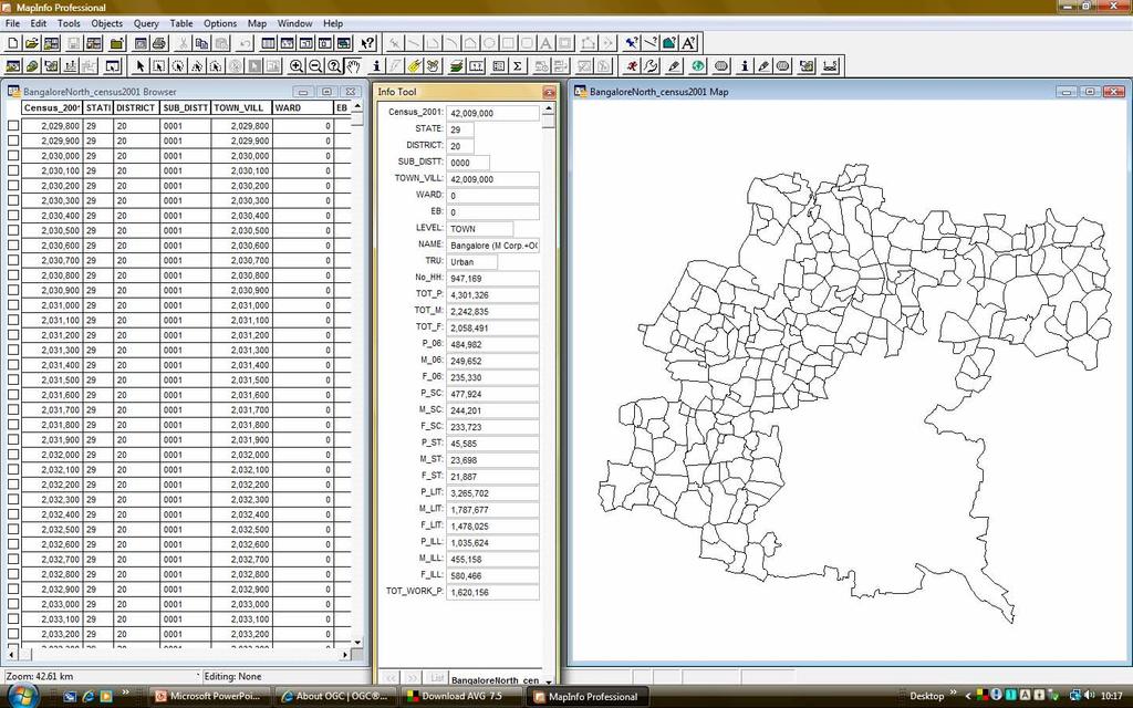
2 DEVELOPMENT OF KARNATAKA STATE SPATIAL DATA INFRASTRUCTURE (KSSDI) PROJECT Objective: To develop a web based Geo Portal to acquire, process, store, distribute and improve the utilization of geo spatial data. Data clearing house which would be a gateway of spatial data being generated by various agencies in the State.
3 Concept of SDI: Spatial Data Infrastructure (SDI) is the technology, policies, standards, human resources, and related activities necessary to acquire, process, distribute, use, maintain, and preserve spatial data.
4 About Karnataka NRDMS Initiated : Funding : DST - GOI and GOK. Implementing Agency : KSCST Objectives: R & D program to develop and demonstrate methods, techniques and tools for operationalising the concept of Decentralized (Local level ) Planning using GIS. To provide analysed information for district level planning using geospatial database. To develop local specific applications using GIS tools. To create awareness among end-users about the utility of GIS technologies by conducting regular training programs and workshops.
5 DATA FROM TOPOSHEETS NRDMS METHODOLOGY STATISTICAL TABLES AERIAL / SATELLITE DATA THEMATIC MAPS THEMATIC MAPS PROCESSING TO COMPUTER COMPATIBLE FORMATS DISTRICT DATABASE PROCESSING CHARTS/ DIAGRAMS DECISION SUPPORT SYSTEM DECISION CENSUS INPUT TO REPORTS MODELS OTHER SECONDARY SOURCES GENERATED / ANALYSED MAPS LIMITED PRIMARY SURVEYS COLLECTION PREPROCESSING STORAGE ANALYSIS USER-ORIENTED RETRIEVALS APPLICATION MODELLING INPUTS PROCESSING STAGES OUTPUTS AGENCIES NRDMS USERS
6 Spatial Data - Natural Resources (1:50,000 scale) - Administration Revenue division Taluks Hoblies Revenue Village boundary Settlement Gram Panchayaths Taluk Panchayaths Constituencies Zilla Panchayaths Constituencies MLA MP Constituencies
7
8 Spatial Data - Natural Resources (1:50,000 scale) Watershed Drainage Tanks River basin Geology Mineral Resources Land use/land cover Soil Land Capability and Productivity maps Forest Slope Geo hydrology with OBW, Rain Gauzing stations-data Hydro geomorphology Road Network
9 Non spatial Database 2001 Census Data (part I and part II) Samanya Mahiti data 21 sectors -357 fields (Infrastructure & Developmental activities-habitation wise) Part of the data will be integrated. Line department data
10 Our Strengths Exhaustive database Semi automated solution for line departments using geodatabase. Skilled man power Geo spatial data - Ideal tool for decision making Good rapport with State Government.
11 Components of State Geo-portal Hardware (Servers, Nodes etc.) Software (OGC compliant software product) WMS,WFS,CSW Customization of database Using UML & GML. Portal development (Interface, applications, development etc.) Infrastructure (UPS and air-conditioning) (Overall maintenance for 2 years)
12 Software (OGC compliant software product) The Open Geospatial Consortium (OGC) The Open Geospatial Consortium (OGC) is an international industry consortium of companies, government agencies and universities participating in a consensus process to develop publicly available interface specifications. OpenGIS Specifications support interoperable solutions that "geo-enable" the Web, wireless and location-based services, and mainstream IT. The specifications empower technology developers to make complex spatial information and services accessible and useful with all kinds of applications.
13 GetFeatureInfo returns information about particular features shown on a map. (GetFeatureInfo interface gives users a way to obtain attribute information about geographic features displayed in a map) A Web Map Service (WMS) 1.1.0/1.3.0 Produces maps of georeferenced data i.e., visual representation. This specification defines three WMS operations: GetCapabilities returns service-level metadata, which is a description of the service's information content and acceptable request parameters; GetMap returns a map image whose geospatial and dimensional parameters are well-defined; (The GetCapabilities and GetMap interfaces specification give users on the web an interoperable way to combine and view map images from different sources)
14 The OGC Web Feature Service (WFS) Implementation Specification allows a client to retrieve and update geospatial data encoded in Geography Markup Language (GML) from multiple WFS. Via these interfaces, a Web user or service can combine, use and manage geodata -- the feature information behind a map image -- from different sources. WFS operations Create a new feature instance Delete Update Lock Get or query features based on spatial and non-spatial constraints
15 OGC CS-W (2.0.1 or higher) Catalogue services support the ability to publish and search collections of descriptive information (metadata) for data, services, and related information objects. The OGC Catalog Service for Web specifies the interfaces, bindings, and a framework for defining application profiles required to publish and access digital catalogues for geospatial data and services. The ISO metadata application profile explains how catalogue services based on the profile are organized and implemented for the discovery and management of geospatial data and service metadata which are compliant with the ISO19115 and standards.
16 Customization of database Unified Modelling Language (UML) The RWO catalogue to be used for developing conceptual data model bringing out the objects and the associations in the formalism confirming to the specifications of ISO (Geographic Information - Rules for Application Schema). OGC Geography Markup Language (GML) Implementation Specification describes an encoding specification for geodata in XML that enables the storage, transport, processing, and transformation of geographic information. (2.1.2 or higher)
17 Ten PC s for collating, updating, validation and verification of district data sets. Data Storage Box - 1 Hardware Servers Geo-portal Server-1 Application Server - 2 Database Server - 1 Backup database server - 1 Security Server 1 Firewall Security issues
18 Portal development Operating System (Linux/Windows) Interface Security issues RDBMS? Payment gateway Applications? (infrastructure, watershed etc.) Maintenance 2 years (on site/call basis)
19 Infrastructure UPS 30 KVA (with backup) Air-conditioning Local Area Network
20 The stages of the system development shall include Requirement analysis System design and architecture Prototype development Refinement of prototype and development of final version. Unit level testing of individual models. Integration testing User acceptance testing (UAT)
21 Scope of Work 1. Requirement analysis 2. Real world object catalogue 3. Conceptual Data Model 4. Centralized database 5. Publishing metadata of data providers other than KSCST 6. Creation of Geo-portal 7. Customization of available software 8. Testing of the Geo-portal/ database/ services 9. User acceptance testing 10. Final deployment of the complete system
22 The developer will evolve a software test plan in consultation with the Council and assist them in conducting user acceptance test.
23 The deliverables include Detailed SRS Design documents Source code with annotations wherever applicable Unit level test script Test cases for UAT and test report User manual Software executables with all the related library files
24

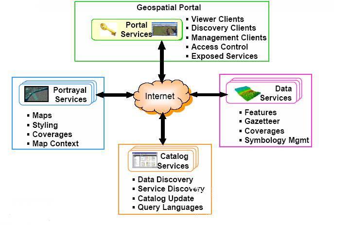
25 Proposed KSSDI Architecture
26 Stakeholders: Users Data Providers System Administrator
27 Users Must be able to login, create/change passwords, and browse relevant parts of the portal. Should be able to discover information using key words Users should be able access data objects/features They should be able to check the status of ongoing queries created by them. They should be able to create new queries, and modify the rules of predefined queries before it has started. They should be able to define new query formats. They should be able to browse a Data catalogue They should be able to directly develop applications on the system. They should be able to close the queries.
28 Data Providers They should be able to put metadata for users, browse the list of requests made by the users. The data of data providers shall be OGC compatible. They should be able to provide catalogue services. They should be able to restrict the end users for specified Information. They should be able to check the status of the user requests.
29 System Administrator The Sys Ad sets up profiles for end users and data providers. They should have control over data access by users. They should be able to add new data products to the existing Catalogue. They should be able to remove data products from the Catalogue. They should be able to restrict user accessing classified information.
30 Technical Presentation ( ) Sl. No. Name of the Company Time 1 Rolta India Ltd Navayuga Spatial Technologies Pvt. Ltd., AVINEON Pvt. Ltd Infotech Enterprises. Ltd., Pixel Softek Pvt. Ltd Tata Consultancy Services SMEC International Pvt. Ltd PCI GEOMATICS India Pvt.Ltd RMSI Pvt. Ltd NIIT GIS Ltd. (ESRI India)
GEO-SPATIAL METADATA SERVICES ISRO S INITIATIVE
 GEO-SPATIAL METADATA SERVICES ISRO S INITIATIVE Pushpalata B Shah, Navita J Thakkar Space Applications Centre (ISRO) Ahmedabad 380 015 - pushpa@sac.isro.gov.in Commission IV, Working Group IV/5 KEYWORDS:
Need Assessment Report KSSDI Geo Portal, System Requirement Specification
 Need Assessment Report KSSDI Geo Portal, System Requirement Specification Project Investigators H Hemanth Kumar, S N Sondur and U T Vijay 2009 Turn Key Solution Provider: Navayuga Spatial Technologies
Introduction to INSPIRE. Network Services
 Introduction to INSPIRE. Network Services European Commission Joint Research Centre Institute for Environment and Sustainability Digital Earth and Reference Data Unit www.jrc.ec.europa.eu Serving society
INSPIRE: The ESRI Vision. Tina Hahn, GIS Consultant, ESRI(UK) Miguel Paredes, GIS Consultant, ESRI(UK)
 Miguel Paredes, GIS Consultant, ESRI(UK)") INSPIRE: The ESRI Vision Tina Hahn, GIS Consultant, ESRI(UK) Miguel Paredes, GIS Consultant, ESRI(UK) Overview Who are we? Introduction to ESRI Inc. and ESRI(UK) Presenters ArcGIS The ESRI Solution to
INSPIRE: The ESRI Vision Tina Hahn, GIS Consultant, ESRI(UK) Miguel Paredes, GIS Consultant, ESRI(UK) Overview Who are we? Introduction to ESRI Inc. and ESRI(UK) Presenters ArcGIS The ESRI Solution to
Tutorial International Standards. Web Map Server (WMS) & Web Feature Server (WFS) Overview
 & Web Feature Server (WFS) Overview") ISO/TC 211 17 th Plenary & Associated Meetings Berlin, Germany, DIN Institute / 2003-10-31 Advisory Group on Outreach Tutorial International Standards Web Map Server (WMS) & Web Feature Server (WFS) Overview
ISO/TC 211 17 th Plenary & Associated Meetings Berlin, Germany, DIN Institute / 2003-10-31 Advisory Group on Outreach Tutorial International Standards Web Map Server (WMS) & Web Feature Server (WFS) Overview
Consolidation Team INSPIRE Annex I data specifications testing Call for Participation
 INSPIRE Infrastructure for Spatial Information in Europe Technical documents Consolidation Team INSPIRE Annex I data specifications testing Call for Participation Title INSPIRE Annex I data specifications
The AAA Model as Contribution to the Standardisation of the Geoinformation Systems in Germany
 The AAA Model as Contribution to the Standardisation of the Geoinformation Systems in Germany Markus SEIFERT, Germany Key words: ISO, CEN, OGC, AdV, Spatial Data Infrastructure SUMMARY Germany is a classic
Service Oriented Architecture For GIS Applications
 The 12 th International Conference of International Association for Computer Methods and Advances in Geomechanics (IACMAG) 1-6 October, 2008 Goa, India Service Oriented Architecture For GIS Applications
The cadastral data and standards based on XML in Poland
 The cadastral data and standards based on XML in Poland Jarosław Bydłosz, Piotr Parzych AGH University of Science and Technology Cracow, Poland 1 XML XML Extensible Markup Language Extensible Markup Language
Leveraging OGC Services in ArcGIS Server. Satish Sankaran, Esri Yingqi Tang, Esri
 Leveraging OGC Services in ArcGIS Server Satish Sankaran, Esri Yingqi Tang, Esri GIS Creating and Managing Geo Information Products - Proprietary - Open Specifications - Standards Dissemination of Geo
International Organization for Standardization Technical Committee 211 (ISO/TC211)
") Esri Support for Geospatial Standards: Open Geospatial Consortium (OGC) International Organization for Standardization Technical Committee 211 (ISO/TC211) An Esri White Paper April 2015 Copyright 2015
Esri Support for Geospatial Standards: Open Geospatial Consortium (OGC) International Organization for Standardization Technical Committee 211 (ISO/TC211) An Esri White Paper April 2015 Copyright 2015
INSPIRE overview and possible applications for IED and E-PRTR e- Reporting Alexander Kotsev
 INSPIRE overview and possible applications for IED and E-PRTR e- Reporting Alexander Kotsev www.jrc.ec.europa.eu Serving society Stimulating innovation Supporting legislation The European data puzzle 24
Esri Support for Geospatial Standards
 APRIL 2017 ArcGIS Is Open and Interoperable Esri Support for Geospatial Standards Copyright 2017 Esri All rights reserved. Printed in the United States of America. The information contained in this document
ADVANCED GEOGRAPHIC INFORMATION SYSTEMS Vol. II - Geospatial Interoperability : The OGC Perspective Open Geospatial Consortium, Inc.
 GEOSPATIAL INTEROPERABILITY: THE OGC PERSPECTIVE Open Open Geospatial Consortium, Wayland, MA, USA Keywords: geographic information systems, geospatial services, interoperability, interface specification,
Metadata for Data Discovery: The NERC Data Catalogue Service. Steve Donegan
 Metadata for Data Discovery: The NERC Data Catalogue Service Steve Donegan Introduction NERC, Science and Data Centres NERC Discovery Metadata The Data Catalogue Service NERC Data Services Case study:
EarthLookCZ as Czech way to GMES
 EarthLookCZ as Czech way to GMES Karel Charvat 1 and Petr Horak 1 1 WirelessInfo, Czech Republic, charvat@wirelessinfo.cz Abstract Global Monitoring for Environment and Security is one of 4 ranges of solutions
Title: Author(s)/Organisation(s): Working Group: References: Quality Assurance: A5.2-D3 [3.7] Information Grounding Service Component Specification
![Title: Author(s)/Organisation(s): Working Group: References: Quality Assurance: A5.2-D3 [3.7] Information Grounding Service Component Specification](/thumbs/80/81830659.jpg "Title: Author(s)/Organisation(s): Working Group: References: Quality Assurance: A5.2-D3 [3.7] Information Grounding Service Component Specification") Title: A5.2-D3 [3.7] Information Grounding Service Component Specification Author(s)/Organisation(s): Ana Belén Antón/ETRA Working Group: Architecture Team/WP05 References: A1.8-D5 User Involvement Document,
Title: A5.2-D3 [3.7] Information Grounding Service Component Specification Author(s)/Organisation(s): Ana Belén Antón/ETRA Working Group: Architecture Team/WP05 References: A1.8-D5 User Involvement Document,
SEXTANT 1. Purpose of the Application
 SEXTANT 1. Purpose of the Application Sextant has been used in the domains of Earth Observation and Environment by presenting its browsing and visualization capabilities using a number of link geospatial
Singapore. Mr Soh Kheng Peng. Singapore Land Authority
 Country Report 2006 (Based on the PCGIAP-Data Integration Template 2006) Singapore Country/state: Name of contact person: Affiliation, Organization: Function, Position: Address: Email address: Tel, Fax
This document is a preview generated by EVS
 TECHNICAL REPORT RAPPORT TECHNIQUE TECHNISCHER BERICHT CEN/TR 15449-5 April 2015 ICS 07.040; 35.240.70 English Version Geographic information - Spatial data infrastructures - Part 5: Validation and testing
METAINFORMATION INFRASTRUCTURE FOR GEOSPATIAL INFORMATION
 2010/2 PAGES 1 7 RECEIVED 15. 6. 2009 ACCEPTED 2. 3. 2010 T. KLIMENT METAINFORMATION INFRASTRUCTURE FOR GEOSPATIAL INFORMATION ABSTRACT Tomáš KLIMENT email: tomas.kliment@stuba.sk Research field: Spatial
A Framework of Information Technology for Water Resources Management
 A Framework of Information Technology for Water Resources Management P.S.V.S. Sridhar T. N. Jowhar Wadia Institute of Himalyan Geology, Anant Bhaskar Garg U. Kedareswarudu ABSTRACT The use of the information
Geospatial Intelligence Interoperability Through Standards Gordon C.Ferrari Chief, Content Standards and Interoperability Division
 Geospatial Intelligence Interoperability Through Standards Gordon C.Ferrari Chief, Content Standards and Interoperability Division 15 May 2002 NIMA Vision and Mission Statements National Imagery and Mapping
Compass INSPIRE Services. Compass INSPIRE Services. White Paper Compass Informatics Limited Block 8, Blackrock Business
 Compass INSPIRE Services White Paper 2010 Compass INSPIRE Services Compass Informatics Limited Block 8, Blackrock Business Park, Carysfort Avenue, Blackrock, County Dublin, Ireland Contact Us: +353 1 2104580
Leveraging OGC Services in ArcGIS Server. Satish Sankaran Yingqi Tang
 Leveraging OGC Services in ArcGIS Server Satish Sankaran ssankaran@esri.com Yingqi Tang ytang@esri.com Agenda Interoperability Enablers OGC and esri OGC Web Services ArcGIS and OGC Web Services - @ version
Setting up the Ihlet Social Cadastre
 Setting up the Ihlet Social Cadastre Ihlet KHT Dr. Attila Molnár, GI consultant Bela Jarolics Rome, Italy TOPICS Goal of the project Architecture Database Solution Standards, communication Metadata Security
The French Geoportal : linking discovery and view network services. INSPIRE Conference Krakow
 The French Geoportal : linking discovery and view network services ( BRGM ) D.Richard (IGN) F. Robida Context of the French Geoportal The governance mechanism Transversal organisation based on the Ministry
Esri Support for Geospatial Standards: OGC and ISO/TC211. An Esri White Paper May 2015
 Esri Support for Geospatial Standards: OGC and ISO/TC211 An Esri White Paper May 2015 Copyright 2015 Esri All rights reserved. Printed in the United States of America. The information contained in this
Regarding the quality attributes, the architecture of the system must be:
 The SDSS System Overview This chapter gives an overview of the software architecture of the RiskChanges SDSS system. One of the objectives within the project is the development of a SDSS system for probabilistic
FDO Data Access Technology at a Glance
 Autodesk Geospatial FDO Data Access Technology at a Glance Work seamlessly with your geospatial data whatever the format 1 The Challenge The growing need for openness and interoperability between traditional
INSPIRE status report
 INSPIRE Team INSPIRE Status report 29/10/2010 Page 1 of 7 INSPIRE status report Table of contents 1 INTRODUCTION... 1 2 INSPIRE STATUS... 2 2.1 BACKGROUND AND RATIONAL... 2 2.2 STAKEHOLDER PARTICIPATION...
SERVO - ACES Abstract
 1 of 6 12/27/2004 2:33 PM 2 of 6 12/27/2004 2:33 PM Implementing GIS Grid Services for the International Solid Earth Research Virtual Observatory Galip Aydin (1), Marlon Pierce (1), Geoffrey Fox (1), Mehmet
Description. Speaker Patrizia Monteduro (International Consultant, FAO) TRAINING GEONETWORK OPENSOURCE Islamabad, Pakistan, Jan 29-31, 2014
 TRAINING GEONETWORK OPENSOURCE Islamabad, Pakistan, Jan 29-31, 2014") BUILDING PROVINCIAL CAPACITY IN PAKISTAN FOR CROP ESTIMATION, FORECASTING, AND REPORTING BASED ON THE INTEGRATED USE OF REMOTELY SENSED DATA (GCP/PAK/125/USA) Description Speaker Patrizia Monteduro (International
BUILDING PROVINCIAL CAPACITY IN PAKISTAN FOR CROP ESTIMATION, FORECASTING, AND REPORTING BASED ON THE INTEGRATED USE OF REMOTELY SENSED DATA (GCP/PAK/125/USA) Description Speaker Patrizia Monteduro (International
Lecture note on the history and principles of geo-webservices
 A SHORT INTRODUCTION TO GEO-WEBSERVICES Lecture note on the history and principles of geo-webservices Barend Köbben Version 1.0 February 24, 2010 Contents 1 From monolithic to distributed GIS architectures
National Geospatial Data Repository Centralised or Distributed?
 National Geospatial Data Repository Centralised or Distributed? Dr. Aniruddha Roy Vice President Navayuga New Delhi, INDIA Presentation Overview NGDR - Prespective NGDR - Stakeholders Boundary Consistency
Jeffery S. Horsburgh. Utah Water Research Laboratory Utah State University
 Advancing a Services Oriented Architecture for Sharing Hydrologic Data Jeffery S. Horsburgh Utah Water Research Laboratory Utah State University D.G. Tarboton, D.R. Maidment, I. Zaslavsky, D.P. Ames, J.L.
Architecture Subgroup Report GEO4DOC 4.1(2) - REV 2.0 UPDATED - POST EO SUMMIT II 13 May 2004
 - REV 2.0 UPDATED - POST EO SUMMIT II 13 May 2004") Ad Hoc Group on Earth Observations (GEO) Report of the Subgroup on Architecture - (Report 2) The following Report of the GEO Subgroup on Architecture is composed of seven sections that collectively satisfy
Ad Hoc Group on Earth Observations (GEO) Report of the Subgroup on Architecture - (Report 2) The following Report of the GEO Subgroup on Architecture is composed of seven sections that collectively satisfy
PortalU, a Tool to Support the Implementation of the Shared Environmental Information System (SEIS) in Germany
 in Germany") European conference of the Czech Presidency of the Council of the EU TOWARDS eenvironment Opportunities of SEIS and SISE: Integrating Environmental Knowledge in Europe http:/www.e-envi2009.org/proceedings/
European conference of the Czech Presidency of the Council of the EU TOWARDS eenvironment Opportunities of SEIS and SISE: Integrating Environmental Knowledge in Europe http:/www.e-envi2009.org/proceedings/
Reducing Consumer Uncertainty
 Spatial Analytics Reducing Consumer Uncertainty Towards an Ontology for Geospatial User-centric Metadata Introduction Cooperative Research Centre for Spatial Information (CRCSI) in Australia Communicate
ERDAS APOLLO Managing and Serving Geospatial Information
 ERDAS APOLLO Managing and Serving Geospatial Information ERDAS APOLLO Do you have large volumes of geospatial information, regularly updated data stores, and a distributed user base? Do you need a single,
A5.2-D3 [3.5] Workflow Design and Construction Service Component Specification. Eva Klien (FHG), Christine Giger (ETHZ), Dániel Kristóf (FOMI)
![A5.2-D3 [3.5] Workflow Design and Construction Service Component Specification. Eva Klien (FHG), Christine Giger (ETHZ), Dániel Kristóf (FOMI)](/thumbs/90/102649368.jpg "A5.2-D3 [3.5] Workflow Design and Construction Service Component Specification. Eva Klien (FHG), Christine Giger (ETHZ), Dániel Kristóf (FOMI)") Title: A5.2-D3 [3.0] A Lightweight Introduction to the HUMBOLDT Framework V3.0 Author(s)/Organisation(s): Daniel Fitzner (FhG), Thorsten Reitz (FhG) Working Group: Architecture Team / WP5 References: A5.2-D3
Title: A5.2-D3 [3.0] A Lightweight Introduction to the HUMBOLDT Framework V3.0 Author(s)/Organisation(s): Daniel Fitzner (FhG), Thorsten Reitz (FhG) Working Group: Architecture Team / WP5 References: A5.2-D3
Marine and Coastal Data Services in the Cloud. Richard Rombouts - Snowflake Software Ltd. & Keiran Millard SeaZone Solutions Ltd.
 Marine and Coastal Data Services in the Cloud Richard Rombouts - Snowflake Software Ltd. & Keiran Millard SeaZone Solutions Ltd. Marine Geospatial Data Inspired Marine Data? SeaZone HydroSpatial Global
The GIGAS Methodology
 The GIGAS Methodology Pier Giorgio Marchetti European Space Agency Earth Observation Programme Ground Segment Department pier.giorgio.marchetti@esa.int GIGAS Objectives GIGAS has the goal to promote the
A service oriented approach for geographical data sharing
 I3E 2005 Conference October 28-30, 2005" A service oriented approach for geographical data sharing Authors L. Vaccari 1, A. Ivanyuckovich 2, and M. Marchese 2 1 Autonomous Province of Trento, Trento, Italy
Using ESRI data in Autodesk ISD Products
 GI13-3 Using ESRI data in Autodesk ISD Products 1.5 hr. Class 02-Dec-03 3:30pm - 5:00pm Session Description: We will focus on using data in a variety of ESRI formats within the Autodesk GIS product line,
Extension of INSPIRE Download Services TG for Observation Data
 Extension of INSPIRE Download Services TG for Observation Data Simon Jirka (52 North) 14 th June 2014, MIG Workshop on WCS-based INSPIRE Download Services Agenda Motivation Sensor Web Proposed Update for
An Open Source Software approach to Spatial Data Infraestructures.
 Second Part INSPIRE and SDI: heterogeneous GI accessing solution An Open Source Software approach to Spatial Data Infraestructures. Study of different scenarios Second Part: INDEX I. Intro: SDI: Beginings,
The Value of Metadata
 The Value of Metadata Why is metadata important to your agency / organization? Metadata has tremendous value to Individuals within your organization, as well as to individuals outside of your organization
RESOURCE ATLAS OVER THE WEB: PRELIMINARY RESULTS
 DISSEMINATION OF THE UAE SOLAR RESOURCE ATLAS OVER THE WEB: PRELIMINARY RESULTS and Research Center for Renewable Energy Mapping and Assessment Masdar Institute of Science and Technology, Abu Dhabi, United
1 Introduction. 2 National Data Exchange Layer
 Spatial Services in the egovernment: Delivering WFS and WMS Queries through the Data Exchange Layer of the Finnish National Architecture for Digital Services Pekka Latvala, Lassi Lehto Finnish Geospatial
DATA SHARING AND DISCOVERY WITH ARCGIS SERVER GEOPORTAL EXTENSION. Clive Reece, Ph.D. ESRI Geoportal/SDI Solutions Team
 DATA SHARING AND DISCOVERY WITH ARCGIS SERVER GEOPORTAL EXTENSION Clive Reece, Ph.D. ESRI Geoportal/SDI Solutions Team Geoportal Extension for ArcGIS Server Context within an Enterprise Spatial Data Infrastructure
Spatial Data on the Web
 Spatial Data on the Web Tools and guidance for data providers The European Commission s science and knowledge service W3C Data on the Web Best Practices 35 W3C/OGC Spatial Data on the Web Best Practices
PRODUCT BROCHURE ERDAS APOLLO MANAGING AND SERVING GEOSPATIAL INFORMATION
 PRODUCT BROCHURE ERDAS APOLLO MANAGING AND SERVING GEOSPATIAL INFORMATION ERDAS APOLLO Do you have large volumes of geospatial information, regularly updated data stores, and a distributed user base? Do
XML and Inter-Operability in Distributed GIS
 XML and Inter-Operability in Distributed GIS KIM Do-Hyun and KIM Min-Soo, Republic of Korea Key words: GML(Geography Markup Language), Interoperability, GIS. SUMMARY Web GIS (Geographic Information Systems)
Challenges that can be overcome with the aid of ESA GIM Click to edit Master text styles
 Click to edit Agenda Master By: Egyptian Survey Authority Geographic Information Management System Kholoud Saad Salama Egypt (ESA GIM) 1 About Egyptian Survey Authority Third ESA GIM level Business Requirements
DanubeGIS User Manual Document number: Version: 1 Date: 11-Nov-2016
 DanubeGIS User Manual Document number: Version: 1 Date: 11-Nov-2016 Imprint Published by: ICPDR International Commission for the Protection of the Danube River ICPDR 2016 Contact ICPDR Secretariat Vienna
The What, Why, Who and How of Where: Building a Portal for Geospatial Data. Alan Darnell Director, Scholars Portal
 The What, Why, Who and How of Where: Building a Portal for Geospatial Data Alan Darnell Director, Scholars Portal What? Scholars GeoPortal Beta release Fall 2011 Production release March 2012 OLITA Award
Cranfield University School of Applied Sciences. MSc Geographical Information Management Academic Year: 2006/2007. Michael Owonibi
 School of Applied Sciences MSc Geographical Information Management Academic Year: 2006/2007 Michael Owonibi The Development of a Prototype Soils Archive Information System to Publish World Soil Data and
OGC Simple Features (for SQL and XML/GML)
") Daniel Wirz, Department of Geography - GIS Division, University of Zurich mailto:wirz@geo.unizh.ch January 2004 What,...? Introduction Develop publicly available geoprocessing specifications. Open interfaces
Daniel Wirz, Department of Geography - GIS Division, University of Zurich mailto:wirz@geo.unizh.ch January 2004 What,...? Introduction Develop publicly available geoprocessing specifications. Open interfaces
Leveraging metadata standards in ArcGIS to support Interoperability. Aleta Vienneau and Marten Hogeweg
 Leveraging metadata standards in ArcGIS to support Interoperability Aleta Vienneau and Marten Hogeweg Leveraging metadata standards in ArcGIS to support Interoperability Overview of metadata standards
Relation between Geospatial information projects related to GBIF
 Relation between Geospatial information projects related to GBIF Synthesys 3.6-Synthesys 3.7-GBIF.DE- BioGeomancer The most up to date work can always be found at: http://www.biogeografia.com/synthesys
Achieving Interoperability Using Open Standards
 FedGIS Conference February 24 25, 2016 Washington, DC Achieving Interoperability Using Open Standards Satish Sankaran Marten Hogeweg Agenda Understanding Interoperability What, Why and How? ArcGIS Platform
MARINE SDI FOR HYDROGRAPHIC HOW HYDROGRAPHIC SURVEYS CAN BENEFIT FROM IMPLEMENTATION OF MARINE SPATIAL DATA INFRASTRUCTURES
 MARINE SDI FOR HYDROGRAPHIC HOW HYDROGRAPHIC SURVEYS CAN BENEFIT FROM IMPLEMENTATION OF MARINE SPATIAL DATA INFRASTRUCTURES MAIN IMAGE: HafenCity: Produced by the Hamburg Port Authority using CARIS BASE
Interoperability with ArcGIS
 Interoperability with ArcGIS Satish Sankaran Marten Hogeweg Agenda Understanding Interoperability What, Why and How? ArcGIS Platform An Open Platform Supporting Interoperability Examples from the real
Achieving Interoperability using the ArcGIS Platform. Satish Sankaran Roberto Lucchi
 Achieving Interoperability using the ArcGIS Platform Satish Sankaran Roberto Lucchi Thank you Please fill out the session survey in your mobile app Select [Achieving Interoperability using the ArcGIS Platform]
Creating Transparency, Openness and Trust: Modern Approach to Redistricting
 Creating Transparency, Openness and Trust: Modern Approach to Redistricting Richard Leadbeater, Esri Jerry Howe, Utah Legislature Larry Boden, Esri NCSL Legislative Summit Sunday, Aug. 6 11:15 am-12:15
ESRI & Interoperability. David Danko ISO TC 211 Metadata Project Leader OGC Metadata WG Chair ESRI Senior Consultant GIS Standards
 ESRI & Interoperability David Danko ISO TC 211 Metadata Project Leader OGC Metadata WG Chair ESRI Senior Consultant GIS Standards ddanko@esri.com GIS has always required Interoperability Social Factors
The European Commission s science and knowledge service. Joint Research Centre
 The European Commission s science and knowledge service Joint Research Centre GeoDCAT-AP The story so far Andrea Perego, Antonio Rotundo, Lieven Raes GeoDCAT-AP Webinar 6 June 2018 What is GeoDCAT-AP Geospatial
OGC Collaborative Platform Undercover
 OGC Collaborative Platform Undercover AGU Fall Meeting 2012 Dec 7, 2012 Greg Buehler; David Arctur; Luis E. Bermudez Open Geospatial Consortium 475 volunteer organizations 4307 Users 60 Standards 2 OGC
User Manual. For Geographical Information System. Last Updated: 1-July-2013 Document No. : - 1 Document version: - 1
 User Manual For Geographical Information System Client: Department of Mines and GIS Government of Karnataka Last Updated: 1-July-2013 Document No. : - 1 Document version: - 1 (Geographical Information
GEOSPATIAL ERDAS APOLLO. Your Geospatial Business System for Managing and Serving Information
 GEOSPATIAL ERDAS APOLLO Your Geospatial Business System for Managing and Serving Information ERDAS APOLLO Do you have large volumes of data, a geographicallydistributed user base and rapidly changing
European Location Framework (ELF) acting as a facilitator implementing INSPIRE
 acting as a facilitator implementing INSPIRE") www.eurogeographics.org European Location Framework (ELF) acting as a facilitator implementing INSPIRE Saulius Urbanas, Mick Cory (EuroGeographics) 29 October 2016 Copyright 2013 EuroGeographics EuroGeographics
www.eurogeographics.org European Location Framework (ELF) acting as a facilitator implementing INSPIRE Saulius Urbanas, Mick Cory (EuroGeographics) 29 October 2016 Copyright 2013 EuroGeographics EuroGeographics
Introduction to SDIs (Spatial Data Infrastructure)
") www.grid.unep.ch Regional training workshop on geographical information system for energy planning Introduction to SDIs (Spatial Data Infrastructure) Dakar, 12 August 2014 Gregory Giuliani Andrea de Bono,
www.grid.unep.ch Regional training workshop on geographical information system for energy planning Introduction to SDIs (Spatial Data Infrastructure) Dakar, 12 August 2014 Gregory Giuliani Andrea de Bono,
Leveraging metadata standards in ArcGIS to support Interoperability. David Danko and Aleta Vienneau
 Leveraging metadata standards in ArcGIS to support Interoperability David Danko and Aleta Vienneau Leveraging Metadata Standards in ArcGIS for Interoperability Why metadata and metadata standards? Overview
ASTROWEB ASTROINFORMATICS PROJECT AND COMPARISON OF THE WEB-GIS PROTOCOL STANDARDS
 Proceedings of the IX Bulgarian-Serbian Astronomical Conference: Astroinformatics (IX BSACA) Sofia, Bulgaria, July 2-4, 2014, Editors: M. K. Tsvetkov, M. S. Dimitrijević, O. Kounchev, D. Jevremović and
Guidelines for the encoding of spatial data
 INSPIRE Infrastructure for Spatial Information in Europe Guidelines for the encoding of spatial data Title Status Creator Date 2012-06-15 Subject Publisher Type Description Contributor Format Source Rights
A5.2-D3 [3.5] Workflow Design and Construction Service Component Specification
![A5.2-D3 [3.5] Workflow Design and Construction Service Component Specification](/thumbs/88/114572244.jpg "A5.2-D3 [3.5] Workflow Design and Construction Service Component Specification") Title: A5.2-D3 [3.5] Workflow Design and Construction Service Component Specification Author(s)/Organisation(s): Daniel Fitzner (FHG), Moses Gone (FHG) Working Group: Architecture Team / WP5 References:
Title: A5.2-D3 [3.5] Workflow Design and Construction Service Component Specification Author(s)/Organisation(s): Daniel Fitzner (FHG), Moses Gone (FHG) Working Group: Architecture Team / WP5 References:
Oracle. Oracle Spatial 11g Essentials. 1z Version: Demo. [ Total Questions: 10] Web:
![Oracle. Oracle Spatial 11g Essentials. 1z Version: Demo. [ Total Questions: 10] Web:](/thumbs/90/101573895.jpg "Oracle. Oracle Spatial 11g Essentials. 1z Version: Demo. [ Total Questions: 10] Web:") Oracle 1z0-595 Oracle Spatial 11g Essentials Version: Demo [ Total Questions: 10] Web: www.myexamcollection.com Email: support@myexamcollection.com IMPORTANT NOTICE Feedback We have developed quality product
Oracle 1z0-595 Oracle Spatial 11g Essentials Version: Demo [ Total Questions: 10] Web: www.myexamcollection.com Email: support@myexamcollection.com IMPORTANT NOTICE Feedback We have developed quality product
Interactive Web Mapping: Overview
 Interactive Web Mapping: Overview Overview of how geospatial data is formatted requested supplied consumed by/for web technologies 2 Definitions Analysis exploring and modeling geospatial phenomena Mapping
INSPIRE & Environment Data in the EU
 INSPIRE & Environment Data in the EU Andrea Perego Research Data infrastructures for Environmental related Societal Challenges Workshop @ pre-rda P6 Workshops, Paris 22 September 2015 INSPIRE in a nutshell
Understanding and Using Metadata in ArcGIS. Adam Martin Marten Hogeweg Aleta Vienneau
 Understanding and Using Metadata in ArcGIS Adam Martin Marten Hogeweg Aleta Vienneau Adam Martin National Government Account Management R&D Open Data Marten Hogeweg National Government Professional Services
International Journal of Spatial Data Infrastructures Research, 2015, Vol.10,
 Assessing existing in-situ capacities in EU Member States: an analysis of the Copernicus regulation approach for Hydrography and Transport Network datasets Massimiliano Rossi 1, Gunter Zeug 2, Tony Blagoev
National Data Sharing and Accessibility Policy-2012 (NDSAP-2012)
") National Data Sharing and Accessibility Policy-2012 (NDSAP-2012) Department of Science & Technology Ministry of science & Technology Government of India Government of India Ministry of Science & Technology
National Data Sharing and Accessibility Policy-2012 (NDSAP-2012) Department of Science & Technology Ministry of science & Technology Government of India Government of India Ministry of Science & Technology
FGDC Standards Program. Presented by Julie Binder Maitra To ISO Standards in Action Workshop November 16, 2013
 FGDC Standards Program Presented by Julie Binder Maitra To ISO Standards in Action Workshop November 16, 2013 1 Topics Policies guiding FGDC standards program FGDC Participation in Non-Federal Standards
The Scottish Spatial Data Infrastructure (SSDI)
") The Scottish Spatial Data Infrastructure (SSDI) INSPIRE Conference Istanbul Monday 25 th June 2012 15:55 Geoportals and registries II Tim Duffy BGS Edinburgh (trd@bgs.ac.uk) Shona Nicol Alex Ramage NERC
The Scottish Spatial Data Infrastructure (SSDI) INSPIRE Conference Istanbul Monday 25 th June 2012 15:55 Geoportals and registries II Tim Duffy BGS Edinburgh (trd@bgs.ac.uk) Shona Nicol Alex Ramage NERC
Web Services for Geospatial Mobile AR
 Web Services for Geospatial Mobile AR Introduction Christine Perey PEREY Research & Consulting cperey@perey.com Many popular mobile applications already use the smartphone s built-in sensors and receivers
INSPIRE & Linked Data: Bridging the Gap Part II: Tools for linked INSPIRE data
 Making the Web an Exploratory Place for Geospatial Knowledge INSPIRE & Linked Data: Bridging the Gap Part II: Tools for linked INSPIRE data Michalis Alexakis Spiros Athanasiou Nikos Georgomanolis Giorgos
Encyclopedia of Information Science and Technology
 Encyclopedia of Information Science and Technology Second Edition Mehdi Khosrow-Pour Information Resources Management Association, USA Volume IV G-Internet INFORMATION SCIENCE REFERENCE Hershey New York
Initial Operating Capability & The INSPIRE Community Geoportal
 INSPIRE Conference, Rotterdam, 15 19 June 2009 1 Infrastructure for Spatial Information in the European Community Initial Operating Capability & The INSPIRE Community Geoportal EC INSPIRE GEOPORTAL TEAM
Country Report : Bhutan. Organization: Disaster Management Division, Ministry of Home and Cultural Affairs. Minister. Secretary
 I. Name: Karma Doma Tshering Country Report : Bhutan II. III. IV. Organization: Disaster Management Division, Ministry of Home and Cultural Affairs Professional Status: Sr. Program Officer Organization
GeoDCAT-AP Representing geographic metadata by using the "DCAT application profile for data portals in Europe"
 GeoDCAT-AP Representing geographic metadata by using the "DCAT application profile for data portals in Europe" Andrea Perego, Vlado Cetl, Anders Friis-Christensen, Michael Lutz, Lorena Hernandez Joint
Presented by Kit Na Goh
 Developing A Geo-Spatial Search Tool Using A Relational Database Implementation of the FGDC CSDGM Model Presented by Kit Na Goh Introduction Executive Order 12906 was issued on April 13, 1994 with the
Metadata of geographic information
 Metadata of geographic information Kai Koistinen Management of environmental data and information 4.10.2017 Topics Metadata of geographic information What is metadata? Metadata standards and recommendations
Implementation of Web Geoservices by National Cartographic Center *
 UNITED NATIONS E/CONF.100/IP.13 ECONOMIC AND SOCIAL COUNCIL Eighteenth United Nations Regional Cartographic Conference for Asia and the Pacific Bangkok, 26-29 October 2009 Item 7(b) of the provisional
Open Geospatial Consortium (OGC) and Web Services (WMS, WFS)
 and Web Services (WMS, WFS)") Open Geospatial Consortium (OGC) and Web Services (WMS, WFS) Responsible persons: Regula Stopper (Overall) Ionut Iosifescu Enescu (Content) Samuel Wiesmann (Revision) Olaf Schnabel (Revision) Content
Open Geospatial Consortium (OGC) and Web Services (WMS, WFS) Responsible persons: Regula Stopper (Overall) Ionut Iosifescu Enescu (Content) Samuel Wiesmann (Revision) Olaf Schnabel (Revision) Content
IHO S-100 Framework. The Essence. WP / Task: Date: Author: hansc/dga Version: 0.6. Document name: IHO S-100 Framework-The Essence
 WP / Task: 4.4.1. Date: 2015-09-25 Author: hansc/dga Version: 0.6 Document name: IHO S-100 Framework-The Essence IHO S-100 Framework Version 0.6 The Essence Document information More recent versions of
New Mexico s RGIS Program: State Geospatial Data Clearinghouse
 New Mexico s RGIS Program: State Geospatial Data Clearinghouse Laura Gleasner Su Zhang November 10, 2016 New Mexico RGIS: The State Digital Geospatial Data Clearinghouse The Resource Geographic Information
ESRI-Supported Open Geospatial Consortium, Inc., and ISO/TC 211 Standards
 ESRI-Supported Open Geospatial Consortium, Inc., and ISO/TC 211 Standards An ESRI White Paper June 2008 ESRI 380 New York St., Redlands, CA 92373-8100 USA TEL 909-793-2853 FAX 909-793-5953 E-MAIL info@esri.com
How to become an INSPIRE node and fully exploit the investments made?
 How to become an INSPIRE node and fully exploit the investments made? Solution patterns for consumers: end users & developers (2/2) Roberto Lucchi 22 June 2010, Krakow 1 Geoportal extension Enabling discovery
Publishing WWII aerial photographs in geographical and library information systems
 Elisabeth Verhelst *, Liesbeth Missel *, Bas Vanmeulebrouk **, Frans. I. Rip *** Publishing WWII aerial photographs in geographical and library information systems Keywords: WWII; aerial photography; geo