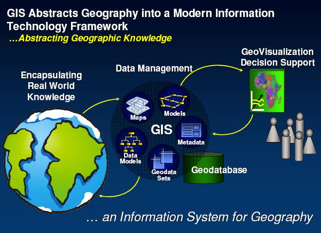
Introduction to SDIs (Spatial Data Infrastructure)
|
|
|
- Sandra McDaniel
- 6 years ago
- Views:
Transcription
1 Regional training workshop on geographical information system for energy planning Introduction to SDIs (Spatial Data Infrastructure) Dakar, 12 August 2014 Gregory Giuliani Andrea de Bono, Bruno Chatenoux Université de Genève UNEP/GRID-Geneva
2 Introduction to SDIs (Spatial Data Infrastructure

3 The Earth is a complex system of systems multidimensional highly interdependent changing (on all spatial and temporal scales)


4 INFORM OBSERVE SHARE

5 One dataset for many users Many datasets for one user


6 Climatologists, Hydrologists, Geologists, Biologists, Ecologists,...


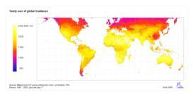
7 Digital Elevation Model Temperatures Precipitations Land Cover Soils
8

9 Data are the fuel for scientific analysis and decision-making
10 Spatial information affects 60-80% of all decisions

11 What is the real situation?

12 Finding environmental data is difficult.
13 There are a lot of environmental data repositories. However, they are heterogeneous, disconnected, hidden to users, and accessing them is often difficult. The are stored in electronic silos of data and are not used efficiently.

14 Operated in isolation...

15 Talking about Landsat... In spite of the great need for that information, the vast majority of those images have never fired a single neuron in a single human brain. Instead, they are stored in electronic silos of data Al Gore (1998)
16 Turning raw data into understandable information Al Gore (1998)

17 Data are expensive to produce More than 50% of time lost in searching data and information while preparing environmental reports. Craglia et al. (2010)


18 Many islands of data of different formats and quality. GLC2000 CORINE GLOBCOVER
19


 data")


20 Geospatial data are difficult to integrate missing documentation (metadata) data fragmentation data replication incompatibilities (formats, models,...) data policies

21 How to connect distributed & heterogenous data sources?
22 Spatial Data Infrastructure

23 An SDI can be seen as enabling environment that supports an easy access to and utilization of geospatial data. SDIs are more than just data repositories. They allow to discover, visualize, evaluate, and access geospatial data and information. This is an environment where users can interact continuously with data. The objective is to bring data as close as possible of the users and answer to their needs.

24 SDIs are aiming to maximize the reuse of data. They can be compared as a road, allowing the movement of data. It is important to keep in mind that SDIs are all about: reuse: data, capabilities, skills, investments,... sharing: data, knowledge,... learning from others: collaboration and co-operation The objective is to facilitate the work of every user Working smarter and not harder


25 Unlock the power of data, information, and services Data can be a shared resource Through an SDI, data can be seen as a shared resource that can be exchanged with other domains and communities. They are like pieces of a puzzle who will fit together and can be useful to different categories of users.


26
27 VISION
28 VISION Support end-users Facilitate discovery and access of existing data Create and make available new data sets Contribute to data sharing initiatives like GEOSS


29 Observing Systems Space-based System Air-based System Cryosphere-based System Land-based System Ocean-based System SS Disasters Climate Water Health Energy Weather Ecosystems Agriculture Biodiversity Societal Benefit Areas


30 Renewable Energy initiative
31 VISION SKILLS FUNDS
 how to share their data and metadata using SDI and OGC")
32 SKILLS GIS training We have taught to more than three hundred participants (in different countries) how to share their data and metadata using SDI and OGC standards.

33 SKILLS Bringing GEOSS services into practice
34 INFRASTRUCT. VISION SKILLS FUNDS

35 INFRASTRUCT. Interoperability We need to make resources coming from different platforms interoperable like to pieces of puzzle who can fit together. Interoperability is the ability of two or more systems or components to exchange information and to use the information that has been exchanged. Interoperability facilitate the integration of data.


36 INFRASTRUCT. Interoperability Metadata Shared best practices Copyright Authorization Standards To facilitate interoperability, several factors come into play. But the most important is the STANDARD. Business models Networks Standards are reference documents defining specifications and providing technical features to ensure interoperability between different components. Agreements Incentives to cooperate Infrastructure Policy framework
 is the leading organization for")
37 INFRASTRUCT. Metadata Copyright Standards Business models Networks Authorization Agreements Incentives to cooperate Policy framework The Open Geospatial Consortium (OGC) is the leading organization for geospatial standards. The provide more than thirty (30) standards for data discovery, visualization, access and Infrastructure processing.
38 rocessing Metadata Data NFRASTRUCT. Web Mapping Service (WMS) HTTP protocol for publishing a collection of layers as a map (PNG, JPEG) Metadata Web Feature Service (WFS) HTTP protocol for publishing feature collections that may be queried and updated by clients (features published as GML, ) Web Coverage Service (WCS) HTTP protocol for publishing coverages (multi-band raster data) that can be accessed by clients (GeoTiff, HDF) Catalog Services for the Web (CS-W) Defines several web interfaces for data discovery Web Processing Service (WPS) Defines an interface to share geoprocessing algorithms

39 metadata data Source: The story of data on the environment
40 DATA INFRA. VISION SKILLS FUNDS


41 Data are essential for two things: Scientific analysis Decision making. Without data and therefore no information, it is difficult to make good sound decisions.


42 DATA INFRA. VISION SKILLS FUNDS
43 SDIs can be thought as social networks of people and organizations supported by data and technology Technology is cheap, data is expensive, but social relations are invaluable Craglia et al. (2009) collaboration, cooperation, social relations


44 Tangibles Technology Framework Analysis 20% technical Tools Methods Systems Intangibles Behaviors Resistance Commitment Accountability Buy-in Self-interests Communication Education Lunch Meeting, ISE, February 3rd % relational People Process Culture

45 Capacity Building Awareness raising

46 Africa Open Data La «donnée ouverte» s'inscrit dans une tendance qui considère l'information publique comme un bien commun dont la diffusion est d'intérêt public et général.

47 DRC Open Data
48 Without sharing environmental data: doing science can be difficult, taking sound decisions can be problematic, and envisioning a sustainable development can be complicated.
49 Publicly funded data are a public good, produced in the public interest and thus should be freely available to the maximum extent possible.
50 Sharing and documenting data is part of the elementary scientific approach. Enhance scientific accountability and credibility.
51 Make your data discoverable Promote GEOSS & OGC
52 Spending more time in doing science... and less in searching data!
53 Merci
SEXTANT 1. Purpose of the Application
 SEXTANT 1. Purpose of the Application Sextant has been used in the domains of Earth Observation and Environment by presenting its browsing and visualization capabilities using a number of link geospatial
Enabling Efficient Discovery of and Access to Spatial Data Services. CHARVAT, Karel, et al. Abstract
 Article Enabling Efficient Discovery of and Access to Spatial Data Services CHARVAT, Karel, et al. Abstract Spatial data represent valuable information and a basis for decision making processes in society.
INSPIRE: The ESRI Vision. Tina Hahn, GIS Consultant, ESRI(UK) Miguel Paredes, GIS Consultant, ESRI(UK)
 Miguel Paredes, GIS Consultant, ESRI(UK)") INSPIRE: The ESRI Vision Tina Hahn, GIS Consultant, ESRI(UK) Miguel Paredes, GIS Consultant, ESRI(UK) Overview Who are we? Introduction to ESRI Inc. and ESRI(UK) Presenters ArcGIS The ESRI Solution to
INSPIRE: The ESRI Vision Tina Hahn, GIS Consultant, ESRI(UK) Miguel Paredes, GIS Consultant, ESRI(UK) Overview Who are we? Introduction to ESRI Inc. and ESRI(UK) Presenters ArcGIS The ESRI Solution to
C3S Data Portal: Setting the scene
 C3S Data Portal: Setting the scene Baudouin Raoult Baudouin.raoult@ecmwf.int Funded by the European Union Implemented by Evaluation & QC function from European commission e.g.,fp7 Space call Selected set
Introduction to INSPIRE. Network Services
 Introduction to INSPIRE. Network Services European Commission Joint Research Centre Institute for Environment and Sustainability Digital Earth and Reference Data Unit www.jrc.ec.europa.eu Serving society
RESOURCE ATLAS OVER THE WEB: PRELIMINARY RESULTS
 DISSEMINATION OF THE UAE SOLAR RESOURCE ATLAS OVER THE WEB: PRELIMINARY RESULTS and Research Center for Renewable Energy Mapping and Assessment Masdar Institute of Science and Technology, Abu Dhabi, United
SDI SOLUTIONS FOR INSPIRE: TECHNOLOGIES SUPPORTING A FRAMEWORK OF COOPERATION
 SDI SOLUTIONS FOR INSPIRE: TECHNOLOGIES SUPPORTING A FRAMEWORK OF COOPERATION Roberto Lucchi 1, Marten Hogeweg 1, Guenther Pichler 2 1 Esri, Redlands, CA, USA 2 Esri Kranzberg, Germany 1 Vision INSPIRE
Webservice-energy.org GEO Community Portal & Spatial Data Infrastructure for Energy
 Webservice-energy.org GEO Community Portal & Spatial Data Infrastructure for Energy Lionel Menard / Oct. 23 2017 Centre Observation, Impacts, Energy Research activities: Use of Earth observation data (Models,
A Study of Mountain Environment Monitoring Based Sensor Web in Wireless Sensor Networks
 , pp.96-100 http://dx.doi.org/10.14257/astl.2014.60.24 A Study of Mountain Environment Monitoring Based Sensor Web in Wireless Sensor Networks Yeon-Jun An 1, Do-Hyeun Kim 2 1,2 Dept. of Computing Engineering
Working with Scientific Data in ArcGIS Platform
 Working with Scientific Data in ArcGIS Platform Sudhir Raj Shrestha sshrestha@esri.com Hong Xu hxu@esri.com Esri User Conference, San Diego, CA. July 11, 2017 What we will cover today Scientific Multidimensional
Next GEOSS der neue europäische GEOSS Hub
 DLR.de Folie 1 27.10.2016, Oberpfaffenhofen Next GEOSS der neue europäische GEOSS Hub J. Meyer-Arnek, A. Müller, G. Schreier DLR.de Folie 2 NextGEOSS-Konsortium Kick-Off: 16-18 JAN 2017 Project duration:
Python: Working with Multidimensional Scientific Data. Nawajish Noman Deng Ding
 Python: Working with Multidimensional Scientific Data Nawajish Noman Deng Ding Outline Scientific Multidimensional Data Ingest and Data Management Analysis and Visualization Extending Analytical Capabilities
Web Map Servers. Mark de Blois. Septembre 2016
 Web Map Servers Mark de Blois Septembre 2016 Learning Objectives After this lecture you will be able to understand web map servers as used in Web-GIS applications Introduction A Web Map Server is a computer
GEOSPATIAL ERDAS APOLLO. Your Geospatial Business System for Managing and Serving Information
 GEOSPATIAL ERDAS APOLLO Your Geospatial Business System for Managing and Serving Information ERDAS APOLLO Do you have large volumes of data, a geographicallydistributed user base and rapidly changing
EXTRA Examples of OGC standards in support of health applications
 EXTRA Examples of OGC standards in support of health applications Some prior / existing initiatives using OGC Standards EU INSPIRE (health and safety working group) GEOSS AIP, EO2Heaven project: EO2HEAVEN
ADVANCED GEOGRAPHIC INFORMATION SYSTEMS Vol. II - Geospatial Interoperability : The OGC Perspective Open Geospatial Consortium, Inc.
 GEOSPATIAL INTEROPERABILITY: THE OGC PERSPECTIVE Open Open Geospatial Consortium, Wayland, MA, USA Keywords: geographic information systems, geospatial services, interoperability, interface specification,
INSPIRE & Environment Data in the EU
 INSPIRE & Environment Data in the EU Andrea Perego Research Data infrastructures for Environmental related Societal Challenges Workshop @ pre-rda P6 Workshops, Paris 22 September 2015 INSPIRE in a nutshell
Scientific and Multidimensional Raster Support in ArcGIS
 Scientific and Multidimensional Raster Support in ArcGIS Sudhir Raj Shrestha sshrestha@esri.com Brief breakdown Scientific Multidimensional data Ingesting Scientific MultiDim Data in ArcGIS Ingesting and
Leveraging OGC Services in ArcGIS Server. Satish Sankaran, Esri Yingqi Tang, Esri
 Leveraging OGC Services in ArcGIS Server Satish Sankaran, Esri Yingqi Tang, Esri GIS Creating and Managing Geo Information Products - Proprietary - Open Specifications - Standards Dissemination of Geo
Basic Principles of MedWIS - WISE interoperability
 Co-ordination committee seminar of the national focal points Basic Principles of MedWIS - WISE interoperability Eduardo García ADASA Sistemas Nice - France Agenda WISE vs MedWIS WISE WISE DS WISE vs WISE
4 th Working Group on Geospatial Information
 4 th Working Group on Geospatial Information Session 5: Contributing to the Work of the Custodian Agencies United Nations Headquarters December 6-8, 2017 Argyro Kavvada, NASA - BAH & EO4SDG Exec. Sec.
Jeffery S. Horsburgh. Utah Water Research Laboratory Utah State University
 Advancing a Services Oriented Architecture for Sharing Hydrologic Data Jeffery S. Horsburgh Utah Water Research Laboratory Utah State University D.G. Tarboton, D.R. Maidment, I. Zaslavsky, D.P. Ames, J.L.
ArcGIS 9.2 Works as a Complete System
 ArcGIS 9.2 Works as a Complete System A New Way to Manage and Disseminate Geographic Knowledge Author/Serve/Use Maps Data Models Globes Metadata Use Desktop Explorer Web Map Viewer Mobile Open APIs Enterprise
INSPIRE overview and possible applications for IED and E-PRTR e- Reporting Alexander Kotsev
 INSPIRE overview and possible applications for IED and E-PRTR e- Reporting Alexander Kotsev www.jrc.ec.europa.eu Serving society Stimulating innovation Supporting legislation The European data puzzle 24
Achieving Interoperability using the ArcGIS Platform. Satish Sankaran Roberto Lucchi
 Achieving Interoperability using the ArcGIS Platform Satish Sankaran Roberto Lucchi Thank you Please fill out the session survey in your mobile app Select [Achieving Interoperability using the ArcGIS Platform]
Standards, standardisation & INSPIRE Status, issues, opportunities
 Standards, standardisation & INSPIRE Status, issues, opportunities INSPIRE Coordination Team 6 th MIG meeting, 13-14 June 2017 Joint Research Centre The European Commission's science and knowledge service
Growing Variety and Volume of Remote Sensing and In Situ Data
 The Potential Role of the World Data Centers in the Global Earth Observing System of Systems and the International Polar Year: CIESIN Experience to Date Dr. Robert S. Chen Director and Senior Research
Oracle Spatial Users Conference
 April 27, 2006 Tampa Convention Center Tampa, Florida, USA Stephen Smith GIS Solutions Manager Large Image Archive Management Solutions Using Oracle 10g Spatial & IONIC RedSpider Image Archive Outline
The GeoPortal Cookbook Tutorial
 The GeoPortal Cookbook Tutorial Wim Hugo SAEON/ SAEOS SCOPE OF DISCUSSION Background and Additional Resources Context and Concepts The Main Components of a GeoPortal Architecture Implementation Options
Windsor Essex Environmental Metadata System (WEEMS)
") Windsor Essex Environmental Metadata System (WEEMS) Utilizing Open Source Geospatial Metadata Technologies For Making g Research Based Data Available for Collaboration Grgicak-Mannion, A 1., Ciborowski,
Windsor Essex Environmental Metadata System (WEEMS) Utilizing Open Source Geospatial Metadata Technologies For Making g Research Based Data Available for Collaboration Grgicak-Mannion, A 1., Ciborowski,
Providing Interoperability Using the Open GeoServices REST Specification
 2013 Esri International User Conference July 8 12, 2013 San Diego, California Technical Workshop Providing Interoperability Using the Open GeoServices REST Specification Satish Sankaran Kevin Sigwart What
An Open Source Software approach to Spatial Data Infraestructures.
 Second Part INSPIRE and SDI: heterogeneous GI accessing solution An Open Source Software approach to Spatial Data Infraestructures. Study of different scenarios Second Part: INDEX I. Intro: SDI: Beginings,
Earth Observation Imperative
 Gregory W. Withee United States Geological Survey (USGS) United States Group on Earth Observation (USGEO) update NRC Board on Research Data and Information January 29, 2009 1 Earth Observation Imperative
Earth observation in implementing Sendai Framework for Disaster Risk Reduction: UN-SPIDER Efforts
 UN-SPIDER Conference, Beijing, 14-16 September 2015 Earth observation in implementing Sendai Framework for Disaster Risk Reduction: 2015-2030 UN-SPIDER Efforts Shirish Ravan Head, UN-SPIDER Beijing Office
The Common Framework for Earth Observation Data. US Group on Earth Observations Data Management Working Group
 The Common Framework for Earth Observation Data US Group on Earth Observations Data Management Working Group Agenda USGEO and BEDI background Concise summary of recommended CFEOD standards today Full document
UAE National Space Policy Agenda Item 11; LSC April By: Space Policy and Regulations Directory
 UAE National Space Policy Agenda Item 11; LSC 2017 06 April 2017 By: Space Policy and Regulations Directory 1 Federal Decree Law No.1 of 2014 establishes the UAE Space Agency UAE Space Agency Objectives
Leveraging OGC Standards on ArcGIS Server
 Leveraging OGC Standards on ArcGIS Server Satish Sankaran Interoperability and Standards Team James Michel III ESRI Intel Team ArcGIS Server Complete Interoperable Server-Based GIS Desktop Explorer Web
Deliverable D3.12. Contract number: OJEU 2010/S Deliverable: D3.12 Author: Igor Antolovic Date: Version: Final
 Deliverable D3.12 Final and public version of the implemented web site with full functionality that hosts all relevant information on the Climate Atlas of the Carpathian Region, including a public download
Welcome. to Pre-bid meeting. Karnataka State Spatial Data Infrastructure (KSSDI) Project, KSCST, Bangalore.
 Project, KSCST, Bangalore.") Welcome to Pre-bid meeting Karnataka State Spatial Data Infrastructure (KSSDI) Project, KSCST, Bangalore. DEVELOPMENT OF KARNATAKA STATE SPATIAL DATA INFRASTRUCTURE (KSSDI) PROJECT Objective: To develop
Welcome to Pre-bid meeting Karnataka State Spatial Data Infrastructure (KSSDI) Project, KSCST, Bangalore. DEVELOPMENT OF KARNATAKA STATE SPATIAL DATA INFRASTRUCTURE (KSSDI) PROJECT Objective: To develop
Lecture note on the history and principles of geo-webservices
 A SHORT INTRODUCTION TO GEO-WEBSERVICES Lecture note on the history and principles of geo-webservices Barend Köbben Version 1.0 February 24, 2010 Contents 1 From monolithic to distributed GIS architectures
The European Commission s science and knowledge service. Joint Research Centre
 The European Commission s science and knowledge service Joint Research Centre GeoDCAT-AP The story so far Andrea Perego, Antonio Rotundo, Lieven Raes GeoDCAT-AP Webinar 6 June 2018 What is GeoDCAT-AP Geospatial
GEO Update and Priorities for 2014
 GEO Update and Priorities for 2014 Osamu Ochiai GEO Secretariat 37 th CEOS WGCV Plenary Frascati, 17-20 Feb 2014 GEO Secretariat Ministerial Summit, Geneva Jan 17 th 2014 Highest number of participants
Smart Islands, Intelligent Nations. Carlyle Roberts, Bahamas Telecommunications Company August 1 st, 2016
 Smart Islands, Intelligent Nations Carlyle Roberts, Bahamas Telecommunications Company August 1 st, 2016 Technology: Constantly Evolving Evolutionary Path Technology: Creating a new world Evolutionary
Outline. The Collaborative Research Platform for Data Curation and Repositories: CKAN For ANGIS Data Portal. Open Access & Open Data.
 Outline The Collaborative Research Platform for Data Curation and Repositories: CKAN For ANGIS Data Portal Open Access & Open Data ANGIS data portal New developed features Future works Hsiung-Ming Liao,
The Logical Data Store
 Tenth ECMWF Workshop on Meteorological Operational Systems 14-18 November 2005, Reading The Logical Data Store Bruce Wright, John Ward & Malcolm Field Crown copyright 2005 Page 1 Contents The presentation
The Science and Technology Roadmap to Support the Implementation of the Sendai Framework for Disaster Risk Reduction
 29 February 2016 The Science and Technology Roadmap to Support the Implementation of the Sendai Framework for Disaster Risk Reduction 2015-2030 The Sendai Framework for Disaster Risk Reduction 2015-2030
EarthLookCZ as Czech way to GMES
 EarthLookCZ as Czech way to GMES Karel Charvat 1 and Petr Horak 1 1 WirelessInfo, Czech Republic, charvat@wirelessinfo.cz Abstract Global Monitoring for Environment and Security is one of 4 ranges of solutions
Achieving Interoperability Using Open Standards
 FedGIS Conference February 24 25, 2016 Washington, DC Achieving Interoperability Using Open Standards Satish Sankaran Marten Hogeweg Agenda Understanding Interoperability What, Why and How? ArcGIS Platform
MY DEWETRA IPAFLOODS REPORT
 Grant Contract N. ECHO/SUB/2014/692292 Programme for Prevention, Preparedness and Response to Floods in the Western Balkans and Turkey IPA FLOODS Capacity Building Activities 2016 MY DEWETRA IPAFLOODS
Metadata for Data Discovery: The NERC Data Catalogue Service. Steve Donegan
 Metadata for Data Discovery: The NERC Data Catalogue Service Steve Donegan Introduction NERC, Science and Data Centres NERC Discovery Metadata The Data Catalogue Service NERC Data Services Case study:
SDI and the Key Elements
 SDI and the Key Elements Roger Longhorn Information Policy Advisor, The Coastal & Marine Union (EUCC) Senior Information Policy Analyst & Principal SDI Expert, Compass Informatics Ltd (Ireland) (www.compass.ie)
Setting up the Ihlet Social Cadastre
 Setting up the Ihlet Social Cadastre Ihlet KHT Dr. Attila Molnár, GI consultant Bela Jarolics Rome, Italy TOPICS Goal of the project Architecture Database Solution Standards, communication Metadata Security
Bruce Wright, John Ward, Malcolm Field, Met Office, United Kingdom
 The Met Office s Logical Store Bruce Wright, John Ward, Malcolm Field, Met Office, United Kingdom Background are the lifeblood of the Met Office. However, over time, the organic, un-governed growth of
Tutorial International Standards. Web Map Server (WMS) & Web Feature Server (WFS) Overview
 & Web Feature Server (WFS) Overview") ISO/TC 211 17 th Plenary & Associated Meetings Berlin, Germany, DIN Institute / 2003-10-31 Advisory Group on Outreach Tutorial International Standards Web Map Server (WMS) & Web Feature Server (WFS) Overview
ISO/TC 211 17 th Plenary & Associated Meetings Berlin, Germany, DIN Institute / 2003-10-31 Advisory Group on Outreach Tutorial International Standards Web Map Server (WMS) & Web Feature Server (WFS) Overview
Extending SOA Infrastructure for Semantic Interoperability
 Extending SOA Infrastructure for Semantic Interoperability Wen Zhu wzhu@alionscience.com ITEA System of Systems Conference 26 Jan 2006 www.alionscience.com/semantic Agenda Background Semantic Mediation
United Nations Spatial Data Infrastructure (UNSDI)
") United Nations Spatial Data Infrastructure (UNSDI) & UN Geographic Information Working Group (UNGIWG) T. Suha ÜLGEN Senior Advisor on Spatial Data Infrastructure Office of the Assistant Secretary-General
United Nations Spatial Data Infrastructure (UNSDI) & UN Geographic Information Working Group (UNGIWG) T. Suha ÜLGEN Senior Advisor on Spatial Data Infrastructure Office of the Assistant Secretary-General
How to become an INSPIRE node and fully exploit the investments made?
 How to become an INSPIRE node and fully exploit the investments made? Solution patterns for consumers: end users & developers (2/2) Roberto Lucchi 22 June 2010, Krakow 1 Geoportal extension Enabling discovery
THE ENVIRONMENTAL OBSERVATION WEB AND ITS SERVICE APPLICATIONS WITHIN THE FUTURE INTERNET Project introduction and technical foundations (I)
") ENVIROfying the Future Internet THE ENVIRONMENTAL OBSERVATION WEB AND ITS SERVICE APPLICATIONS WITHIN THE FUTURE INTERNET Project introduction and technical foundations (I) INSPIRE Conference Firenze,
ENVIROfying the Future Internet THE ENVIRONMENTAL OBSERVATION WEB AND ITS SERVICE APPLICATIONS WITHIN THE FUTURE INTERNET Project introduction and technical foundations (I) INSPIRE Conference Firenze,
Call for Participation in AIP-6
 Call for Participation in AIP-6 GEOSS Architecture Implementation Pilot (AIP) Issue Date of CFP: 9 February 2013 Due Date for CFP Responses: 15 March 2013 Introduction GEOSS Architecture Implementation
Training Workshop Developing Rich Web mapping Applications Tunis, May 2016
 Training Workshop Developing Rich Web mapping Applications Tunis, 10 12 May 2016 1 Introduction With the advance of web mapping services and web technology, creating and publishing high-performing, modern-looking
SII Law Organization Coordination activities Examples of good practices Education Technical matters Success stories Challenges
 SII Law Organization Coordination activities Examples of good practices Education Technical matters Success stories Challenges INSPIRE transposed by the legal act on Spatial Information Infrastructure
INSPIRE in a nutshell, and overview of the European Union Location Framework
 INSPIRE in a nutshell, and overview of the European Union Location Framework Francesco Pignatelli European Commission, DG JRC 10 th European Congress and Exhibition on Intelligent Transport Systems and
TerrainOnDemand ArcGIS
 TM TerrainOnDemand ArcGIS Connect to Intermap Technologies NEXTMap data within: ArcGIS Desktop 9.3.1 and Above AGDQS0312 TerrainOnDemand ArcGIS 2 TerrainOnDemand ArcGIS Table of Contents 1. Introduction...1
Building Resilience to Disasters for Sustainable Development: Visakhapatnam Declaration and Plan of Action
 Building Resilience to Disasters for Sustainable Development: Visakhapatnam Declaration and Plan of Action Adopted at the Third World Congress on Disaster Management Visakhapatnam, Andhra Pradesh, India
Leveraging OGC Services in ArcGIS Server. Satish Sankaran Yingqi Tang
 Leveraging OGC Services in ArcGIS Server Satish Sankaran ssankaran@esri.com Yingqi Tang ytang@esri.com Agenda Interoperability Enablers OGC and esri OGC Web Services ArcGIS and OGC Web Services - @ version
Extend GIS. The Reach. Of Your GIS. Chris Cappelli Nathan Bennett
 Extend The Reach GIS Of Your GIS Chris Cappelli Nathan Bennett Where do your co-workers, managers, customers, and citizens go when they want to find or make a map? GIS is a practical system for problem
Long-term preservation for INSPIRE: a metadata framework and geo-portal implementation
 Long-term preservation for INSPIRE: a metadata framework and geo-portal implementation INSPIRE 2010, KRAKOW Dr. Arif Shaon, Dr. Andrew Woolf (e-science, Science and Technology Facilities Council, UK) 3
GeoDCAT-AP Representing geographic metadata by using the "DCAT application profile for data portals in Europe"
 GeoDCAT-AP Representing geographic metadata by using the "DCAT application profile for data portals in Europe" Andrea Perego, Vlado Cetl, Anders Friis-Christensen, Michael Lutz, Lorena Hernandez Joint
E-Agricultural Services and Business
 E-Agricultural Services and Business The Sustainable Web Portal for Observation Data Naiyana Sahavechaphan, Jedsada Phengsuwan, Nattapon Harnsamut Sornthep Vannarat, Asanee Kawtrakul Large-scale Simulation
European Space Policy
 European Space Policy Eleni Paliouras, ESA EuroGeographics General Assembly 3 October 2017 Vienna, Austria ESA UNCLASSIFIED - For Official Use ESA facts and figures Intergovernmental agency of 22 Member
UPU UNIVERSAL POSTAL UNION. CA C 4 SDPG AHG DRM Doc 3. Original: English COUNCIL OF ADMINISTRATION. Committee 4 Development Cooperation
 UPU UNIVERSAL POSTAL UNION CA C 4 SDPG AHG DRM 2014.1-Doc 3 Original: English COUNCIL OF ADMINISTRATION Committee 4 Development Cooperation Sustainable Development Project Group Ad hoc group on Disaster
UAE Space Policy Efforts Towards Long Term Sustainability of Space Activities Agenda Item 4; COPUOS June 2017 By: Space Policy and
 UAE Space Policy Efforts Towards Long Term Sustainability of Space Activities Agenda Item 4; COPUOS 2017 07-16 June 2017 By: Space Policy and Regulations Directory 1 The UAE will build the first city on
Earth Observation, Climate and Space for Smarter Government
 Earth Observation, Climate and Space for Smarter Government Beth Greenaway, Head of Earth Observation 30 March 2015 http://www.bis.gov.uk/ukspaceagency Overview UK Space Agency EO Importance and priorities
Striving for efficiency
 Ron Dekker Director CESSDA Striving for efficiency Realise the social data part of EOSC How to Get the Maximum from Research Data Prerequisites and Outcomes University of Tartu, 29 May 2018 Trends 1.Growing
 Plone development in UNEP Country Environmental Profiles Gerard.Cunningham@unep.org Capacity Building and Partnerships Section Division of Early Warning and Assessment United Nations Environment Programme
ARCHITECTURE OF SPATIAL DATA INFRASTRUCTURE (SDI) (DRAFT)
 (DRAFT)") ARCHITECTURE OF SPATIAL DATA INFRASTRUCTURE (SDI) (DRAFT) Author: Carlo Cipolloni September 20, 2018 Version 1.0 A SDI platform to support the SEIS in the ENP South region Introduction Based on the Contribution
ARCHITECTURE OF SPATIAL DATA INFRASTRUCTURE (SDI) (DRAFT) Author: Carlo Cipolloni September 20, 2018 Version 1.0 A SDI platform to support the SEIS in the ENP South region Introduction Based on the Contribution
DATA SHARING AND DISCOVERY WITH ARCGIS SERVER GEOPORTAL EXTENSION. Clive Reece, Ph.D. ESRI Geoportal/SDI Solutions Team
 DATA SHARING AND DISCOVERY WITH ARCGIS SERVER GEOPORTAL EXTENSION Clive Reece, Ph.D. ESRI Geoportal/SDI Solutions Team Geoportal Extension for ArcGIS Server Context within an Enterprise Spatial Data Infrastructure
GEOSS Data Management Principles: Importance and Implementation
 GEOSS Data Management Principles: Importance and Implementation Alex de Sherbinin / Associate Director / CIESIN, Columbia University Gregory Giuliani / Lecturer / University of Geneva Joan Maso / Researcher
Global Soil Data Task - part of Earth Data Sets (IN-02-C2) Vincent van Engelen - ISRIC Task Point of Contact
 Vincent van Engelen - ISRIC Task Point of Contact") - part of Earth Data Sets (IN-02-C2) Vincent van Engelen - ISRIC Task Point of Contact What is GEO / GEOSS? The Group on Earth Observations (GEO) is coordinating efforts to build a Global Earth Observation
- part of Earth Data Sets (IN-02-C2) Vincent van Engelen - ISRIC Task Point of Contact What is GEO / GEOSS? The Group on Earth Observations (GEO) is coordinating efforts to build a Global Earth Observation
Background Note on Possible arrangements for a Technology Facilitation Mechanism and other science, technology and innovation issues
 Background Note on Possible arrangements for a Technology Facilitation Mechanism and other science, technology and innovation issues Introduction This background note outlines, in a non-exhaustive manner,
Interoperability and gvsig
 CEN/TC 287 Madrid, 25-02-2009 Interoperability and gvsig Gabriel Carrión Rico Francisco José Peñarrubia Jorge Piera Llodrá Carlos Sánchez Periñán Director of gvsig project. Conselleria D' Infraestructures
The Hyogo Framework for Action: an instrument to reduce the impact of disasters
 1 22 February 2007 The Hyogo Framework for Action: an instrument to reduce the impact of disasters Dialogue on Private-Public Partnerships in Disaster Risk Reduction Global Facility for Disaster Reduction
Development and Implementation of International and Regional Flash Flood Guidance (FFG) and Early Warning Systems. Project Brief
 and Early Warning Systems. Project Brief") Development and Implementation of International and Regional Flash Flood Guidance (FFG) and Early Warning Systems Project Brief 1 SUMMARY The purpose of this project is the development and implementation
Development and Implementation of International and Regional Flash Flood Guidance (FFG) and Early Warning Systems Project Brief 1 SUMMARY The purpose of this project is the development and implementation
Compass INSPIRE Services. Compass INSPIRE Services. White Paper Compass Informatics Limited Block 8, Blackrock Business
 Compass INSPIRE Services White Paper 2010 Compass INSPIRE Services Compass Informatics Limited Block 8, Blackrock Business Park, Carysfort Avenue, Blackrock, County Dublin, Ireland Contact Us: +353 1 2104580
Global Earth Observation System of Systems. GEO Secretariat Geneva, Switzerland
 Global Earth Observation System of Systems GEO Secretariat Geneva, Switzerland Group on Earth Observations Intergovernmental Organization with 81 Members and 58 Participating Organizations (including WMO)
Financing resilience at the subnational 22 JUNE 2014 STANDING COMMITTEE ON FINANCE FORUM, MONTEGO BAY, JAMAICA
 Financing resilience at the subnational level in South Africa 22 JUNE 2014 STANDING COMMITTEE ON FINANCE FORUM, MONTEGO BAY, JAMAICA My key takeaways from 21 June 2014 1. Improve access to finance through
Thinking cities. Khalil Laaboudi. Smart & Sustainable Cities. Global Marketing
 Thinking cities Khalil Laaboudi Smart & Sustainable Cities Global Marketing Thinking Cities -- Agenda I. Ericsson in the World and in Hong Kong II. III. IV. Networked Society and other global trends New
A/AC.105/C.1/2013/CRP.6
 14 February 2013 English only Committee on the Peaceful Uses of Outer Space Scientific and Technical Subcommittee Fiftieth session Vienna, 11-12 February 2013 Item 8 of the provisional agenda * Space-system-based
New Mexico s RGIS Program: State Geospatial Data Clearinghouse
 New Mexico s RGIS Program: State Geospatial Data Clearinghouse Laura Gleasner Su Zhang November 10, 2016 New Mexico RGIS: The State Digital Geospatial Data Clearinghouse The Resource Geographic Information
CREATING SMART TRANSPORT SERVICES BY FACILITATING THE RE-USE OF OPEN GIS DATA
 OPEN TRANSPORT NET TOMAS MILDORF 16 JUNE 2014 INSPIRE CONFERENCE 2014, AALBORG, DENMARK CREATING SMART TRANSPORT SERVICES BY FACILITATING THE RE-USE OF OPEN GIS DATA 2 1 OTN AT A GLANCE Full title OpenTransportNet
PortalU, a Tool to Support the Implementation of the Shared Environmental Information System (SEIS) in Germany
 in Germany") European conference of the Czech Presidency of the Council of the EU TOWARDS eenvironment Opportunities of SEIS and SISE: Integrating Environmental Knowledge in Europe http:/www.e-envi2009.org/proceedings/
European conference of the Czech Presidency of the Council of the EU TOWARDS eenvironment Opportunities of SEIS and SISE: Integrating Environmental Knowledge in Europe http:/www.e-envi2009.org/proceedings/
Interoperability Between GRDC's Data Holding And The GEOSS Infrastructure
 City University of New York (CUNY) CUNY Academic Works International Conference on Hydroinformatics 8-1-2014 Interoperability Between GRDC's Data Holding And The GEOSS Infrastructure Volker Andres Henning
Grid-enabled Spatial Data Infrastructure serving GEOSS, INSPIRE, and UNSDI. GIULIANI, Gregory, et al. Abstract
 Report Grid-enabled Spatial Data Infrastructure serving GEOSS, INSPIRE, and UNSDI GIULIANI, Gregory, et al. Abstract The aim of this document is to present the grid-enabled SDI developed in the context
Relation between Geospatial information projects related to GBIF
 Relation between Geospatial information projects related to GBIF Synthesys 3.6-Synthesys 3.7-GBIF.DE- BioGeomancer The most up to date work can always be found at: http://www.biogeografia.com/synthesys
Public Private Partnership based on the NSDI of Spain: Regulation and examples from the National Geographic Institute. Título. Sebastián Mas-Mayoral
 1 Public Private Partnership based on the NSDI of Spain: Regulation and examples from the National Geographic Institute. Título Sebastián Mas-Mayoral 2 PPP in Spain Public private partnership is usually
Implementing a Data Quality Strategy to simplify access to data
 IN43D-07 AGU Fall Meeting 2016 Implementing a Quality Strategy to simplify access to data Kelsey Druken, Claire Trenham, Ben Evans, Clare Richards, Jingbo Wang, & Lesley Wyborn National Computational Infrastructure,
SAFER the GIGAS Effect
 SAFER the GIGAS Effect How INSPIRE, GMES and GEOSS are influencing EC projects Arnaud Cauchy 23/06/2010 Agenda GIGAS Project Summary SAFER Project Summary SAFER Original Approach GIGAS Influences SAFER
The NextGEOSS Project
 NextGEOSS GEOSS Interoperability workshop 28 August 2017 The NextGEOSS Project Marie-Francoise Voidrot, Bart De Lathouwer Open Geospatial Consortium Europe Nuno Catarino DEIMOS Head of Data Systems NextGEOSS
An Interoperable GIS solution for the public administration (extended abstract)
") An Interoperable GIS solution for the public administration (extended abstract) Artur Rocha, João Correia Lopes, Luís Bártolo, Rui Chilro INESC-Porto, Rua Dr. Roberto Frias, N o 378 4200-465 PORTO, Portugal,
An Interoperable GIS solution for the public administration (extended abstract) Artur Rocha, João Correia Lopes, Luís Bártolo, Rui Chilro INESC-Porto, Rua Dr. Roberto Frias, N o 378 4200-465 PORTO, Portugal,
Development of a Protected Areas Database for Jamaica
 Progress Report Technical and Financial Development of a Protected Areas Database for Jamaica Grants for Digital Data Protected Areas Thematic Network Prepared by: Projects Planning & Monitoring Branch