Putting Your Data on the Map
|
|
|
- Kristopher Bell
- 6 years ago
- Views:
Transcription
1 Putting Your Data on the Map Cyndy Chandler WHOI Marine Chemistry Department Woods Hole Data Mongers / Ocean Informatics Meeting 4 April WHOI
2 Finding the OI in WHOI What is Ocean Informatics? The work of Ocean Informatics is represented at the union of oceanography, information science and social science domains. Participants range from data and information managers to scientific researchers and educators. for more information see Karen Baker s work at SIO
3 my recent & current OI projects... US JGOFS DMO US Joint Global Ocean Flux Study OCB DMO Ocean Carbon & Biogeochemistry BCO-DMO Biological and Chemical Oceanography


4 U.S. JGOFS legacy data is available online or in data reports published on CD and DVD-ROM online access is via http or OpenDAP access to data system subset, list, plot or download all data

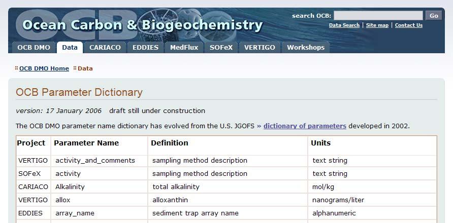
5 Ocean Carbon & Biogeochemistry project is still active; acquiring data database is available online online access is via http subset, list, plot or download data
6 Biological & Chemical Oceanography project was funded in Fall 2006 by NSF Peter Wiebe and Bob Groman (Biology) Dave Glover and Cyndy Chandler (MCG) data team: Dicky Allison (Biology), Nancy Copley (Biology), Dave DuBois (G&G), Terry McKee (PO)


7 Biological & Chemical Oceanography no data available yet intend to provide data management support for projects funded by NSF OCE Biology and Chemistry Divisions data access will be provided from
8
9 Data Access data are loaded into an object-oriented relational database, QC d and metadata records created access via http and OpenDAP Live Access Server interface for some controlled vocabulary for column names

10 U.S. JGOFS Data System Web interface
 select range (rows) view metadata")
11 Data Listing select dataset select variable (columns) select range (rows) view metadata
12 Live Access Server Interface configurable Web server data and metadata interface provides access to geo-referenced scientific data presents distributed data sets as a unified virtual data base (DODS/OpenDAP) uses Ferret as the default visualization application visualize data with on-the-fly graphics request custom subsets of variables in a variety of file formats access background reference material (metadata) compare variables from distributed sources
13 LAS enables a data server to unify access to multiple types of data in a single interface create thematic data collections from distributed data sources offer derived products on the fly offer variety of visualization styles customized for the data
14 U.S. JGOFS LAS Interface interface to data and metadata data sub-selection (selections, projections) multi-variable support gridded vs. in-situ data differencing multiple views (property-property, depth horizon, cruise tracks, overplots) multiple products (ps, gif, text, NetCDF)


15 LAS v6 select dataset and variables

16 select dataset select variable set constraints select view (XYZT) select output type selections: lat/lon time depth range LAS constraints

17 LAS select dataset select variable set constraints output output

18 Comparison Overlay Plot
 at 10 meters")
19 chlorophyll (May) shaded Nitrate (April) at 10 meters contours
20 Controlled Vocabularies
21 Data Access ~ next steps system design changes to improve interoperability with other data systems MapServer (UMN) interface OpenGIS specifications metadata standard FGDC, ISO 19115, EML

22 U.S. JGOFS MapServer interface being developed today by Charlton Purvis (Second Creek Consulting)

23 U.S. JGOFS MapServer interface
24 MapServer software University of Minnesota (UMN) OpenSource software for rendering geographic image maps from data create maps to aid in data discovery cross-platform (Linux, Windows, Mac OS X, Solaris) Open Geospatial Consortium (OGC) OpenGIS specifications: WMS (client/server), non-transactional WFS (client/server), WMC, WCS, Filter Encoding, SLD, GML, SOS
U.S. GEOTRACES PACIFIC TRANSECT DATA MANAGEMENT
 U.S. GEOTRACES PACIFIC TRANSECT DATA MANAGEMENT Cyndy Chandler BCO-DMO WHOI US GEOTRACES Pacific Zonal Transect Planning Workshop Woods Hole, MA USA 26 April 2013 1 of 31 TOPICS 1. What is BCO-DMO? 2.
DATA ACCESS TUTORIAL 2013 OCB PI Summer Workshop
 http://bco-dmo.org DATA ACCESS TUTORIAL 2013 OCB PI Summer Workshop Data access: TEXT-BASED SEARCH scenario 1: You have a general idea of what you are looking for. Go to: http://bco-dmo.org The DATABASE
Geospatial Access and Data Display Adds Value to Data Management at the Biological and Chemical Oceanographic Data Management Office
 Geospatial Access and Data Display Adds Value to Data Management at the Biological and Chemical Oceanographic Data Management Office M. Dickson Allison 1 and Charlton Galvarino 2 1 Woods Hole Oceanographic
Introduction to Data Management for Ocean Science Research
 Introduction to Data Management for Ocean Science Research Cyndy Chandler Biological and Chemical Oceanography Data Management Office 12 November 2009 Ocean Acidification Short Course Woods Hole, MA USA
Interoperability ~ An Introduction
 Interoperability ~ An Introduction Cyndy Chandler Biological and Chemical Oceanography Data Management Office (BCO-DMO) Woods Hole Oceanographic Institution 26 July 2008 MMI OOS Interoperability Planning
NSF Proposals and the Two Page Data Management Plan. 14 January 2011 Cyndy Chandler
 1 NSF Proposals and the Two Page Data Management Plan 14 January 2011 Cyndy Chandler 1 of 20 2 The Two Page Plan all NSF proposals (after January 17, 2011) must include a supplementary document of no more
An Open Source Software approach to Spatial Data Infraestructures.
 Second Part INSPIRE and SDI: heterogeneous GI accessing solution An Open Source Software approach to Spatial Data Infraestructures. Study of different scenarios Second Part: INDEX I. Intro: SDI: Beginings,
The Common Framework for Earth Observation Data. US Group on Earth Observations Data Management Working Group
 The Common Framework for Earth Observation Data US Group on Earth Observations Data Management Working Group Agenda USGEO and BEDI background Concise summary of recommended CFEOD standards today Full document
Online intercomparison of models and observations using OGC and community standards
 Online intercomparison of models and observations using OGC and community standards Alastair Gemmell * Jon Blower Keith Haines Adit Santokhee Reading e-science e Centre, Environmental Systems Science Centre,
Web Services for Geospatial Mobile AR
 Web Services for Geospatial Mobile AR Introduction Christine Perey PEREY Research & Consulting cperey@perey.com Many popular mobile applications already use the smartphone s built-in sensors and receivers
Adoption of Data Citation Outcomes by BCO-DMO
 Adoption of Data Citation Outcomes by BCO-DMO Cynthia Chandler, Adam Shepherd, David Bassendine Biological and Chemical Oceanography Data Management Office Woods Hole Oceanographic Institution and Blue
Current JGOFS DMTT activities, and data management requirements for future marine biogeochemical projects - insights for modelers
 1 Current JGOFS DMTT activities, and data management requirements for future marine biogeochemical projects - insights for modelers Margarita Conkright Ocean Climate Laboratory National Oceanographic Data
Achieving Interoperability using the ArcGIS Platform. Satish Sankaran Roberto Lucchi
 Achieving Interoperability using the ArcGIS Platform Satish Sankaran Roberto Lucchi Thank you Please fill out the session survey in your mobile app Select [Achieving Interoperability using the ArcGIS Platform]
Data discovery and access via the SeaDataNet CDI system
 Data discovery and access via the SeaDataNet CDI system Central dataproducts and data services on distributed data. Peter Thijsse MARIS CLIPC IS-ENES workshop, KNMI, November 2014 Outline 1. Introduction
Setting up the Ihlet Social Cadastre
 Setting up the Ihlet Social Cadastre Ihlet KHT Dr. Attila Molnár, GI consultant Bela Jarolics Rome, Italy TOPICS Goal of the project Architecture Database Solution Standards, communication Metadata Security
Interoperability in Science Data: Stories from the Trenches
 Interoperability in Science Data: Stories from the Trenches Karen Stocks University of California San Diego Open Data for Open Science Data Interoperability Microsoft escience Workshop 2012 Interoperability
Rolling Deck to Repository: Opportunities for US-EU Collaboration
 Rolling Deck to Repository: Opportunities for US-EU Collaboration Stephen Miller Scripps Institution of Oceanography La Jolla, California USA http://gdc.ucsd.edu Co-authors: Helen Glaves British Geological
Using the Network Common Data Form for storage of atmospheric data
 Using the Network Common Data Form for storage of atmospheric data Maarten Plieger Royal Netherlands Meteorological Institute The NetCDF4 data format (Network Common Data Form) is used within the ADAGUC
European Marine Data Exchange
 European Marine Data Exchange By Dick M.A. Schaap MARIS (NL) EU SeaDataNet Technical Coordinator EU EMODnet Ingestion Coordinator Noordzeedagen 2018 - October 2018 Acquisition of ocean and marine data
Leveraging metadata standards in ArcGIS to support Interoperability. Aleta Vienneau and Marten Hogeweg
 Leveraging metadata standards in ArcGIS to support Interoperability Aleta Vienneau and Marten Hogeweg Leveraging metadata standards in ArcGIS to support Interoperability Overview of metadata standards
Leveraging OGC Services in ArcGIS Server. Satish Sankaran, Esri Yingqi Tang, Esri
 Leveraging OGC Services in ArcGIS Server Satish Sankaran, Esri Yingqi Tang, Esri GIS Creating and Managing Geo Information Products - Proprietary - Open Specifications - Standards Dissemination of Geo
ADVANCED GEOGRAPHIC INFORMATION SYSTEMS Vol. II - Geospatial Interoperability : The OGC Perspective Open Geospatial Consortium, Inc.
 GEOSPATIAL INTEROPERABILITY: THE OGC PERSPECTIVE Open Open Geospatial Consortium, Wayland, MA, USA Keywords: geographic information systems, geospatial services, interoperability, interface specification,
Metadata for Data Discovery: The NERC Data Catalogue Service. Steve Donegan
 Metadata for Data Discovery: The NERC Data Catalogue Service Steve Donegan Introduction NERC, Science and Data Centres NERC Discovery Metadata The Data Catalogue Service NERC Data Services Case study:
EarthLookCZ as Czech way to GMES
 EarthLookCZ as Czech way to GMES Karel Charvat 1 and Petr Horak 1 1 WirelessInfo, Czech Republic, charvat@wirelessinfo.cz Abstract Global Monitoring for Environment and Security is one of 4 ranges of solutions
Developing a Free and Open Source Software based Spatial Data Infrastructure. Jeroen Ticheler
 Developing a Free and Open Source Software based Spatial Data Infrastructure Jeroen Ticheler 1 License This work is licensed under the Creative Commons Attribution-NonCommercial-ShareAlike 2.5 License.
IDL DISCOVER WHAT S IN YOUR DATA
 IDL DISCOVER WHAT S IN YOUR DATA IDL Discover What s In Your Data. A key foundation of scientific discovery is complex numerical data. If making discoveries is a fundamental part of your work, you need
EMODnet Bathymetry. By Dick M.A. Schaap Coordinator. 20 th April 2016, EGU 2016, Vienna - Austria
 EMODnet Bathymetry By Dick M.A. Schaap Coordinator 20 th April 2016, EGU 2016, Vienna - Austria EMODNet Bathymetry Ongoing in 3 consecutive projects since 2009 with expanding consortium (at present >30
Desarrollo de una herramienta de visualización de datos oceanográficos: Modelos y Observaciones
 Desarrollo de una herramienta de visualización de datos oceanográficos: Modelos y Observaciones J. Fernandez, J. Lopez, I. Carlos, F. Jerez, F. Hermosilla, M. Espino SIMO, LIM-UPC, CIIRC FIELD_AC 7 th
Ontology and Application for Reusable Search Interface Design
 Ontology and Application for Reusable Search Interface Design Plans for Advanced Semantic Technologies Final Project Eric Rozell, Tetherless World Constellation Outline Project Overview Paper Contents
Leveraging metadata standards in ArcGIS to support Interoperability. David Danko and Aleta Vienneau
 Leveraging metadata standards in ArcGIS to support Interoperability David Danko and Aleta Vienneau Leveraging Metadata Standards in ArcGIS for Interoperability Why metadata and metadata standards? Overview
Introduction to INSPIRE. Network Services
 Introduction to INSPIRE. Network Services European Commission Joint Research Centre Institute for Environment and Sustainability Digital Earth and Reference Data Unit www.jrc.ec.europa.eu Serving society
New Datasets, Functionality and Future Development. Ashwanth Srinivasan, (FSU) Steve Hankin (NOAA/PMEL) Major contributors: Jon Callahan (Mazama(
 Steve Hankin (NOAA/PMEL) Major contributors: Jon Callahan (Mazama(") HYCOM Data Service New Datasets, Functionality and Future Development Ashwanth Srinivasan, (FSU) Steve Hankin (NOAA/PMEL) Major contributors: Jon Callahan (Mazama( Consulting) Roland Schweitzer (Weathertop
HYCOM Data Service New Datasets, Functionality and Future Development Ashwanth Srinivasan, (FSU) Steve Hankin (NOAA/PMEL) Major contributors: Jon Callahan (Mazama( Consulting) Roland Schweitzer (Weathertop
Catalog-driven, Reproducible Workflows for Ocean Science
 Catalog-driven, Reproducible Workflows for Ocean Science Rich Signell, USGS, Woods Hole, MA, USA Filipe Fernandes, Centro Universidade Monte Serrat, Santos, Brazil. 2015 Boston Light Swim, Aug 15, 7:00am
Uniform Resource Locator Wide Area Network World Climate Research Programme Coupled Model Intercomparison
 Glossary API Application Programming Interface AR5 IPCC Assessment Report 4 ASCII American Standard Code for Information Interchange BUFR Binary Universal Form for the Representation of meteorological
Serving Large-Scale Coverages - How to Tame an Elephant
 Serving Large-Scale s - How to Tame an Elephant OGC Workshop 2 INSPIRE Conference Edinburgh, 29-jun-2011 Peter Baumann Jacobs University rasdaman GmbH OGC WCS.SWG chair OGC spec editor Sensor & Image Data
The GeoPortal Cookbook Tutorial
 The GeoPortal Cookbook Tutorial Wim Hugo SAEON/ SAEOS SCOPE OF DISCUSSION Background and Additional Resources Context and Concepts The Main Components of a GeoPortal Architecture Implementation Options
Consolidation Team INSPIRE Annex I data specifications testing Call for Participation
 INSPIRE Infrastructure for Spatial Information in Europe Technical documents Consolidation Team INSPIRE Annex I data specifications testing Call for Participation Title INSPIRE Annex I data specifications
INSPIRE: The ESRI Vision. Tina Hahn, GIS Consultant, ESRI(UK) Miguel Paredes, GIS Consultant, ESRI(UK)
 Miguel Paredes, GIS Consultant, ESRI(UK)") INSPIRE: The ESRI Vision Tina Hahn, GIS Consultant, ESRI(UK) Miguel Paredes, GIS Consultant, ESRI(UK) Overview Who are we? Introduction to ESRI Inc. and ESRI(UK) Presenters ArcGIS The ESRI Solution to
INSPIRE: The ESRI Vision Tina Hahn, GIS Consultant, ESRI(UK) Miguel Paredes, GIS Consultant, ESRI(UK) Overview Who are we? Introduction to ESRI Inc. and ESRI(UK) Presenters ArcGIS The ESRI Solution to
Deliverable D3.12. Contract number: OJEU 2010/S Deliverable: D3.12 Author: Igor Antolovic Date: Version: Final
 Deliverable D3.12 Final and public version of the implemented web site with full functionality that hosts all relevant information on the Climate Atlas of the Carpathian Region, including a public download
SERVO - ACES Abstract
 1 of 6 12/27/2004 2:33 PM 2 of 6 12/27/2004 2:33 PM Implementing GIS Grid Services for the International Solid Earth Research Virtual Observatory Galip Aydin (1), Marlon Pierce (1), Geoffrey Fox (1), Mehmet
The Integrated Data Viewer A Tool for Scientific Analysis and Visualization
 The Integrated Data Viewer A Tool for Scientific Analysis and Visualization Don Murray Unidata Program Center Overview What is the Integrated Data Viewer (IDV)? IDV features Web enabled features Client/Server
FDO Data Access Technology at a Glance
 Autodesk Geospatial FDO Data Access Technology at a Glance Work seamlessly with your geospatial data whatever the format 1 The Challenge The growing need for openness and interoperability between traditional
Oracle Spatial Users Conference
 April 2006 April 27, 2006 Tampa Convention Center Tampa, Florida, USA April 2006 Michael Smith Physical Scientist Remote Sensing/GIS Center of Expertise Army Corps of Engineers Engineer Research & Development
Relation between Geospatial information projects related to GBIF
 Relation between Geospatial information projects related to GBIF Synthesys 3.6-Synthesys 3.7-GBIF.DE- BioGeomancer The most up to date work can always be found at: http://www.biogeografia.com/synthesys
Leveraging OGC Standards on ArcGIS Server
 Leveraging OGC Standards on ArcGIS Server Satish Sankaran Interoperability and Standards Team James Michel III ESRI Intel Team ArcGIS Server Complete Interoperable Server-Based GIS Desktop Explorer Web
ASTROWEB ASTROINFORMATICS PROJECT AND COMPARISON OF THE WEB-GIS PROTOCOL STANDARDS
 Proceedings of the IX Bulgarian-Serbian Astronomical Conference: Astroinformatics (IX BSACA) Sofia, Bulgaria, July 2-4, 2014, Editors: M. K. Tsvetkov, M. S. Dimitrijević, O. Kounchev, D. Jevremović and
Beyond Rasters: Introducing The New OGC Web Coverage Service 2.0
 Beyond Rasters: Introducing The New OGC Web Coverage Service 2.0 Peter Baumann Jacobs University Bremen rasdaman GmbH Jacobs University Bremen International, multi-cultural,300+ students, 0 nations, 75%
Integrated Map Tool. Overview, Current Status, and Things to Come
 Integrated Map Tool Overview, Current Status, and Things to Come Integrated Mapping and Analysis Tool (IMAT) map widget Integrated Mapping Tool IMAT Reusable components for portrayal, query, analysis,
Development of an information service system based on GOOGLE graphical interfaces. Instruction for the use of the MOON-VOS portal Interface
 Development of an information service system based on GOOGLE graphical interfaces Instruction for the use of the MOON-VOS portal Interface Giuseppe M.R. Manzella ENEA Operational Oceanography, p.o. box
Towards a pan-european infrastructure for marine and ocean data management + Importance of standards
 Towards a pan-european infrastructure for marine and ocean data management + Importance of standards By Dick M.A. Schaap MARIS Technical Coordinator SeaDataNet & ODIP Coordinator EMODnet Bathymetry Münster
ERDAS APOLLO Managing and Serving Geospatial Information
 ERDAS APOLLO Managing and Serving Geospatial Information ERDAS APOLLO Do you have large volumes of geospatial information, regularly updated data stores, and a distributed user base? Do you need a single,
Welcome. to Pre-bid meeting. Karnataka State Spatial Data Infrastructure (KSSDI) Project, KSCST, Bangalore.
 Project, KSCST, Bangalore.") Welcome to Pre-bid meeting Karnataka State Spatial Data Infrastructure (KSSDI) Project, KSCST, Bangalore. DEVELOPMENT OF KARNATAKA STATE SPATIAL DATA INFRASTRUCTURE (KSSDI) PROJECT Objective: To develop
Welcome to Pre-bid meeting Karnataka State Spatial Data Infrastructure (KSSDI) Project, KSCST, Bangalore. DEVELOPMENT OF KARNATAKA STATE SPATIAL DATA INFRASTRUCTURE (KSSDI) PROJECT Objective: To develop
HYCOM Data Service and Web Outreach
 HYCOM Data Service and Web Outreach A. Srinivasan 1, S. Hankin, P. Cornillon, and E. P. Chassignet 1 Center for Ocean-Atmospheric Prediction Studies, Florida State University phone: (850) 644-7462 fax:
CMSP Discovery Vocabularies Workshop. A Joint WHOI/USGS/NOAA Workshop
 CMSP Discovery Vocabularies Workshop A Joint WHOI/USGS/NOAA Workshop Agenda Wed. Dec. 1 12:00 Opening Lunch 1:00 Introductions and Review of Meeting: Andy Maffei, WHOI 1:30 Overview of the National Ocean
OceanBrowser: on-line visualization of gridded ocean data and in situ observations
 OceanBrowser: on-line visualization of gridded ocean data and in situ observations Alexander Barth¹, Sylvain Watelet¹, Charles Troupin², Aida Alvera Azcarate¹, Giorgio Santinelli³, Gerrit Hendriksen³,
What is ODV? ver h.p://odv.awi.de/ Currently 46,300 registered users, ~20 new users every day!!
 OCN 623 How to use ODV ver. 4.7.4 h.p://odv.awi.de/ Currently 46,300 registered users, ~20 new users every day!! Jan 21, 2016 What is ODV? Ocean Data View (ODV) is a so1ware package for the interac8ve
Open Geospatial Consortium (OGC) and Web Services (WMS, WFS)
 and Web Services (WMS, WFS)") Open Geospatial Consortium (OGC) and Web Services (WMS, WFS) Responsible persons: Regula Stopper (Overall) Ionut Iosifescu Enescu (Content) Samuel Wiesmann (Revision) Olaf Schnabel (Revision) Content
Open Geospatial Consortium (OGC) and Web Services (WMS, WFS) Responsible persons: Regula Stopper (Overall) Ionut Iosifescu Enescu (Content) Samuel Wiesmann (Revision) Olaf Schnabel (Revision) Content
International Organization for Standardization Technical Committee 211 (ISO/TC211)
") Esri Support for Geospatial Standards: Open Geospatial Consortium (OGC) International Organization for Standardization Technical Committee 211 (ISO/TC211) An Esri White Paper April 2015 Copyright 2015
Esri Support for Geospatial Standards: Open Geospatial Consortium (OGC) International Organization for Standardization Technical Committee 211 (ISO/TC211) An Esri White Paper April 2015 Copyright 2015
Esri Support for Geospatial Standards
 APRIL 2017 ArcGIS Is Open and Interoperable Esri Support for Geospatial Standards Copyright 2017 Esri All rights reserved. Printed in the United States of America. The information contained in this document
Setting Up and Deploying Geospatial Data Shares Using the QGIS Server Application
 Setting Up and Deploying Geospatial Data Shares Using the QGIS Server Application Donald L. Schrupp Wildlife Ecologist Colorado Division of Wildlife (retired) Quantum GIS (QGIS) Applications QGIS is not
Towards a pan-european infrastructure for marine and ocean data management + Importance of standards
 Towards a pan-european infrastructure for marine and ocean data management + Importance of standards By Dick M.A. Schaap Technical Coordinator SeaDataNet & Coordinator EMODnet Bathymetry Hydrography Day,
Tutorial International Standards. Web Map Server (WMS) & Web Feature Server (WFS) Overview
 & Web Feature Server (WFS) Overview") ISO/TC 211 17 th Plenary & Associated Meetings Berlin, Germany, DIN Institute / 2003-10-31 Advisory Group on Outreach Tutorial International Standards Web Map Server (WMS) & Web Feature Server (WFS) Overview
ISO/TC 211 17 th Plenary & Associated Meetings Berlin, Germany, DIN Institute / 2003-10-31 Advisory Group on Outreach Tutorial International Standards Web Map Server (WMS) & Web Feature Server (WFS) Overview
SCSODC: Integrating Ocean Data for Visualization Sharing and Application
 IOP Conference Series: Earth and Environmental Science OPEN ACCESS SCSODC: Integrating Ocean Data for Visualization Sharing and Application To cite this article: C Xu et al 2014 IOP Conf. Ser.: Earth Environ.
Data Management Components for a Research Data Archive
 Data Management Components for a Research Data Archive Steven Worley and Bob Dattore Scientific Computing Division Computational and Information Systems Laboratory National Center for Atmospheric Research
OGC Collaborative Platform Undercover
 OGC Collaborative Platform Undercover AGU Fall Meeting 2012 Dec 7, 2012 Greg Buehler; David Arctur; Luis E. Bermudez Open Geospatial Consortium 475 volunteer organizations 4307 Users 60 Standards 2 OGC
Standards, GML and AIXM. Dr. David Burggraf Vice President Galdos Systems Inc
 Standards, and AIXM Dr. David Burggraf Vice President Galdos Systems Inc Copyright Galdos Systems Inc. May 6, 2010 Geography Markup Language: What is it? A modeling language for geographic features A set
RESOURCE ATLAS OVER THE WEB: PRELIMINARY RESULTS
 DISSEMINATION OF THE UAE SOLAR RESOURCE ATLAS OVER THE WEB: PRELIMINARY RESULTS and Research Center for Renewable Energy Mapping and Assessment Masdar Institute of Science and Technology, Abu Dhabi, United
OGC Compliance Infrastructure
 OGC Compliance Infrastructure INSPIRE workshop on validation and conformity Ispra, Italy May 16, 2014 Luis Bermudez, Sebastian Goerke 10 Years providing compliance 300+ Copyright 2014 Open Geospatial Consortium
Service Oriented Architecture For GIS Applications
 The 12 th International Conference of International Association for Computer Methods and Advances in Geomechanics (IACMAG) 1-6 October, 2008 Goa, India Service Oriented Architecture For GIS Applications
Webservice-energy.org GEO Community Portal & Spatial Data Infrastructure for Energy
 Webservice-energy.org GEO Community Portal & Spatial Data Infrastructure for Energy Lionel Menard / Oct. 23 2017 Centre Observation, Impacts, Energy Research activities: Use of Earth observation data (Models,
Introduction to SDIs (Spatial Data Infrastructure)
") www.grid.unep.ch Regional training workshop on geographical information system for energy planning Introduction to SDIs (Spatial Data Infrastructure) Dakar, 12 August 2014 Gregory Giuliani Andrea de Bono,
www.grid.unep.ch Regional training workshop on geographical information system for energy planning Introduction to SDIs (Spatial Data Infrastructure) Dakar, 12 August 2014 Gregory Giuliani Andrea de Bono,
Scientific and Multidimensional Raster Support in ArcGIS
 Scientific and Multidimensional Raster Support in ArcGIS Sudhir Raj Shrestha sshrestha@esri.com Brief breakdown Scientific Multidimensional data Ingesting Scientific MultiDim Data in ArcGIS Ingesting and
Programming with the Semantic Web. Adam Shepherd C. Chandler, R. Arko, D. Fils, D. Kinkade, M. Jones
 Programming with the Semantic Web Adam Shepherd C. Chandler, R. Arko, D. Fils, D. Kinkade, M. Jones Oceanographic Cruise: Linking to Authoritative Source http://seft.com.tr/web/wp-content/uploads/2015/02/rsv66_01.png
Observations and Measurements
 Observations and Measurements issues and upgrades Simon Cox CSIRO Exploration & Mining http://www.em.csiro.au Goal of Observations and Measurements Information model for Sensor Web Enablement consistent
SeaDataNet, Pan-European infrastructure for marine and ocean data management + EMODNET
 SeaDataNet, Pan-European infrastructure for marine and ocean data management + EMODNET By Dick M.A. Schaap Technical Coordinator SeaDataNet & Coordinator EMODNet Bathymetry San Francisco USA, 13 December
The Many Facets of THREDDS Thematic Real-time Environmental Distributed Data Services
 The Many Facets of THREDDS Thematic Real-time Environmental Distributed Data Services For March 2007 Unidata Policy Committee Meeting Ben Domenico 1 Motivation From the Unidata 2003 proposal: utilizing
Oceanography and Ocean Data Assimilation Geospatial Data Grids
 Oceanography and Ocean Data Assimilation Geospatial Data Grids Keith Haines Environmental Systems Science Centre (ESSC), Reading University Reading e-science Centre www.resc.reading.ac.uk New technology
Technical documentation. SIOS Data Management Plan
 Technical documentation SIOS Data Management Plan SIOS Data Management Plan Page: 2/10 SIOS Data Management Plan Page: 3/10 Versions Version Date Comment Responsible 0.3 2017 04 19 Minor modifications
ArcGIS 9.2 Works as a Complete System
 ArcGIS 9.2 Works as a Complete System A New Way to Manage and Disseminate Geographic Knowledge Author/Serve/Use Maps Data Models Globes Metadata Use Desktop Explorer Web Map Viewer Mobile Open APIs Enterprise
BIG DATA CHALLENGES A NOAA PERSPECTIVE
 BIG DATA CHALLENGES A NOAA PERSPECTIVE Dr. Edward J. Kearns NASA Examiner, Science and Space Branch, OMB/EOP and Chief (acting), Remote Sensing and Applications Division National Climatic Data Center National
DMAC Report to the GCOOS BOD. GCOOS Board of Directors Meeting Biloxi, MS February 2008
 DMAC Report to the GCOOS BOD GCOOS Board of Directors Meeting Biloxi, MS 26-27 February 2008 GCOOS DMAC Membership 2008 Steve Anderson - Horizon Marine! Brenda Babin - LUMCON! Steve Beaudet - SAIC! Julie
Observation trends: Expectations from European Comission regarding data exchange and interoperability
 Observation trends: Expectations from European Comission regarding data exchange and interoperability Marcin Wichorowski (IO PAN), Sławomir Sagan (IO PAN), Declan Dunne (UCC MaREI), John Barton (UCC-TYNDALL)
US NODC Archival Management Practices and the OAIS Reference Model Donald W. Collins
 US NODC Archival Management Practices and the OAIS Reference Model Donald W. Collins National Oceanographic Data Center SSMC3 4 TH Floor, 1315 East West Hwy, Silver Spring MD 20910 Donald.Collins@noaa.gov
NOTICE. This document is only one section of a larger document. All sections together collectively form the NNEW Documentation.
 NOTICE This document is only one section of a larger document. All sections together collectively form the NNEW Documentation. Please be advised that: This section may need to be interpreted in the context
INSPIRE Conference 2018 (18 21 September, Antwerp)
") INSPIRE Conference 2018 (18 21 September, Antwerp) Introduction The Marine Strategy Framework Directive (MSFD) of the European Commission defines some obligations for the implementation of strategies for
INSPIRE Conference 2018 (18 21 September, Antwerp) Introduction The Marine Strategy Framework Directive (MSFD) of the European Commission defines some obligations for the implementation of strategies for
Semantically enhancing SensorML with controlled vocabularies in the marine domain
 Semantically enhancing SensorML with controlled vocabularies in the marine domain KOKKINAKI ALEXANDRA, BUCK JUSTIN, DARROCH LOUISE, JIRKA SIMON AND THE MARINE PROFILES FOR OGC SENSOR WEB ENABLEMENT STANDARDS
GENeric European Sustainable Information Space for Environment.
 GENeric European Sustainable Information Space for Environment http://www.genesis-fp7.eu/ Outline Introduction The GENESIS FP7 project The GENESIS solution s architecture GENESIS experience with INSPIRE
ESRI & Interoperability. David Danko ISO TC 211 Metadata Project Leader OGC Metadata WG Chair ESRI Senior Consultant GIS Standards
 ESRI & Interoperability David Danko ISO TC 211 Metadata Project Leader OGC Metadata WG Chair ESRI Senior Consultant GIS Standards ddanko@esri.com GIS has always required Interoperability Social Factors
Jeffery S. Horsburgh. Utah Water Research Laboratory Utah State University
 Advancing a Services Oriented Architecture for Sharing Hydrologic Data Jeffery S. Horsburgh Utah Water Research Laboratory Utah State University D.G. Tarboton, D.R. Maidment, I. Zaslavsky, D.P. Ames, J.L.
Reducing Consumer Uncertainty
 Spatial Analytics Reducing Consumer Uncertainty Towards an Ontology for Geospatial User-centric Metadata Introduction Cooperative Research Centre for Spatial Information (CRCSI) in Australia Communicate
Lecture note on the history and principles of geo-webservices
 A SHORT INTRODUCTION TO GEO-WEBSERVICES Lecture note on the history and principles of geo-webservices Barend Köbben Version 1.0 February 24, 2010 Contents 1 From monolithic to distributed GIS architectures
Ocean, Atmosphere & Climate Model Assessment for Everyone
 Ocean, Atmosphere & Climate Model Assessment for Everyone Rich Signell USGS Woods Hole, MA Unidata 2014 DeSouza Award Presentation Boulder, CO : Sep 15, 2014 2 US Integrated Ocean Observing System (IOOS
ISA Action 1.17: A Reusable INSPIRE Reference Platform (ARE3NA)
") ISA Action 1.17: A Reusable INSPIRE Reference Platform (ARE3NA) Expert contract supporting the Study on RDF and PIDs for INSPIRE Deliverable D.EC.3.2 RDF in INSPIRE Open issues, tools, and implications
ISA Action 1.17: A Reusable INSPIRE Reference Platform (ARE3NA) Expert contract supporting the Study on RDF and PIDs for INSPIRE Deliverable D.EC.3.2 RDF in INSPIRE Open issues, tools, and implications
Python: Working with Multidimensional Scientific Data. Nawajish Noman Deng Ding
 Python: Working with Multidimensional Scientific Data Nawajish Noman Deng Ding Outline Scientific Multidimensional Data Ingest and Data Management Analysis and Visualization Extending Analytical Capabilities
J1.6 MONITORING AND ANALYZING THE GLOBAL OCEAN OBSERVING SYSTEM WITH THE OBSERVING SYSTEM MONITORING CENTER
 J1.6 MONITORING AND ANALYZING THE GLOBAL OCEAN OBSERVING SYSTEM WITH THE OBSERVING SYSTEM MONITORING CENTER Kevin M. O'Brien 1*,S. Hankin 2, R. Schweitzer 3, K. Kern 4, M. Little 4,T. Habermann 5, N. Auerbach
GISCI GEOSPATIAL CORE TECHNICAL KNOWLEDGE EXAM CANDIDATE MANUAL AUGUST 2017
 GISCI GEOSPATIAL CORE TECHNICAL KNOWLEDGE EXAM CANDIDATE MANUAL AUGUST 2017 This document provides information about the GISCI Geospatial Core Technical Knowledge Exam, now a requirement for GISCI GISP
INSPIRE overview and possible applications for IED and E-PRTR e- Reporting Alexander Kotsev
 INSPIRE overview and possible applications for IED and E-PRTR e- Reporting Alexander Kotsev www.jrc.ec.europa.eu Serving society Stimulating innovation Supporting legislation The European data puzzle 24
Abstract. Introduction. OGC Web Coverage Service 2.0
 786 Introducing WCS 2.0, EO-WCS, and Open Source Implementations (MapServer, rasdaman, and EOxServer) Enabling the Online Data Access to Heterogeneous Multi-dimensional Satellite Data Christian SCHILLER,
GeoDCAT-AP Representing geographic metadata by using the "DCAT application profile for data portals in Europe"
 GeoDCAT-AP Representing geographic metadata by using the "DCAT application profile for data portals in Europe" Andrea Perego, Vlado Cetl, Anders Friis-Christensen, Michael Lutz, Lorena Hernandez Joint
West Coast Observation Project. West Coast Observing System Project Brief
 West Coast Observation Project Click to edit Master text styles Second level Third level Fourth level» Fifth level West Coast Observing System Project Brief Prepared by NCDDC August 2007 1 Outline West