May 2013 Oracle Spatial and Graph User Conference
|
|
|
- Rodger Dixon
- 5 years ago
- Views:
Transcription

1 May 2013 Oracle Spatial and Graph User Conference

2 May 22, 2013 Ronald Reagan Building and International Trade Center Washington, DC USA
3 Paul Calhoun & Vince Smith GIS Systems Analyst City Of Virginia Beach GeoMedia Product Line Executive Intergraph
4 Land Information Management Parcel and Address Management using GeoMedia & Oracle Workspace Manager
5 Program Agenda Virginia Beach RACS Virginia Beach Background Parcel and Address Management Processes GeoMedia Transaction Management using Oracle Workspace Manager System Metrics & Benefits
6 Revenue and Collection System OVERVIEW Centrally managed, authoritative database Incorporates multiple city business units Supports GIS, Real Estate Assessors Office, Commissioner of Revenue, Treasurers Office CHALLENGES / OPPORTUNITIES Need to integrate disparate data sets GIS Tax-Maps, Appraisals and Revenue Collection. Most records do not contain lat/long coordinates Maintain multiple data versions and history SOLUTIONS Oracle Database Enterprise Edition Spatial Option Workspace Manager feature of Oracle Database Intergraph GeoMedia Professional, Parcel Manager, and Transaction Manager RESULTS Organization now better understands activities in context of location Standardized all addresses and coordinates in a consistent format and datum Improved precision thereby making system more useful to the public and business Users can query as-built, proposed and historical versions of the data

 Water 59 sq.")


7 Virginia Beach Background 440,000 Population 3 Million Tourists per year Land 248 sq. miles (642 km 2 ) Water 59 sq. miles (153 km 2 ) Beaches* 35 miles (*Atlantic Ocean and Chesapeake Bay) Ave. Elevation 12 above sea level (4 meters)
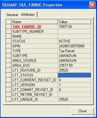
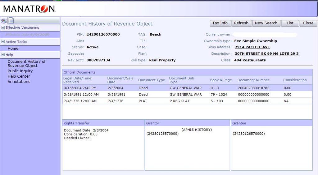
8 TaxMap Database 150,000 Parcels 200,000 Point Addresses Parcel Transactions per year 3 Member Team GeoMedia Parcel Manager GTM With Oracle Database 10g Release 2 Oracle Spatial (SDO_GEOMETRY) format Custom API to Synchronize with Manatron GRM

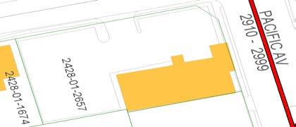
9 Parcel Management


10 Address Update Process
11 Background Our primary goal was to have a single process that we could manage, create and retire, tax parcels. Our secondary goal was to develop a system that could manage address information in relationship to parcels, being able to track the address of a particular parcel. We contracted Manatron with Intergraph as a sub, who developed and Implemented the TaxMap database. We went live in July 2007, and been using the software ever since to manage both parcels and addresses.

12 Results and Benefits The current system is very successful because it reduced the number of Synchronization issues from 1500 parcels to zero. It enables a single point of entry for GPIN and address information, which can be easily distributed through the enterprise. The GIS2GRM interface saves the City time and money, because it reduces the time it takes to create and populate new land records. Populates GPIN, Address, Source Document, Lot and Legal Description. Reduces Data Entry errors.
13 Central model Current Model Updated with API in realtime Contains Parcels and Addresses in the same model Coordinated with GRM touch the records one time Supports future growth since it is a relational model with unique ID and relates.
14

15 TaxMap Model
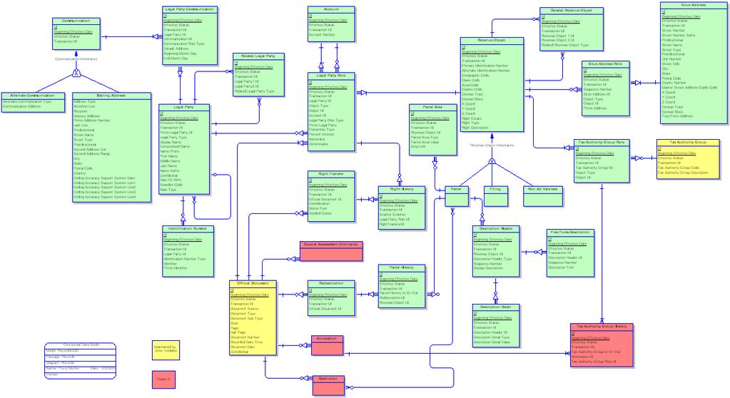
16 GRM Model


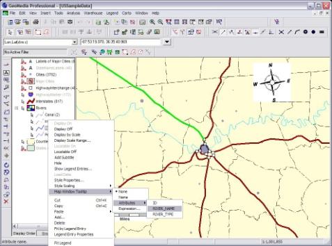
17 What is GeoMedia? A highly productive environment for capturing and editing geospatial data Allows users to analyze geospatial data from various sources in a single integrated view Effectively uses enterprise-oriented, industry standard database management systems, such as Oracle, or use open interfaces for data exchange, such as OGC s WMS and WFS interfaces Allows customer to incorporate geospatial data to effectively run their daily operations and make critical business decisions

18 What is GeoMedia Parcel? Maintain parcel boundaries for easements, property or cadaster Optimized COGO entry of survey plans and plats Perform parcel splits or joins Produce cadaster maps for tax assessments


19 What is GeoMedia Transaction Manager? Allows multiple users to simultaneously access and edit the same feature data in an enterprise environment Gives users confidence that all edits to feature data are maintained without having to put processes in place restricting users to perform edits sequentially Manage the lifecycle of your data as features transition from one state to another ensuring the integrity of the data at all points in time Query and visualize your geospatial data at various points in time


20 Benefits of Workspace Manager + GeoMedia Optimistic and pessimistic locking for enterprise environments with 100 s of users there s no worries with what is being edited, by whom or when Row level locking every geospatial entity or asset can be managed effectively Conflict view visually inspect and resolve edits History of all data changes perform complex, ad-hoc analysis across different versions of the data


21 Benefits of OWM + GeoMedia Workspace hierarchy allows large organizations to perform quality control and assurance at multiple levels Valid time & effective dating include past and future representations of the data as part of the analysis (temporal query) or visually display (temporal filter) GeoMedia users can manage geospatial assets, using the full power of GeoMedia technology with the added benefits of Workspace Manager in Oracle Database
22 Q&A
23 What is GeoMedia? Data Access Live access to extensive number of data warehouses and formats Oracle Data Server CAD Data Server ArcView Data Server dgn dxf shp KML Data Server GeoMedia GML Data Server WFS Data Server WMS Data Server WCS Data Server gml


24 What is GeoMedia? Placement & Editing Capture feature data using GeoMedia s extensive set of placement commands Point, line and area placement Point to point digitizing Placement by circle and arc Oriented to related features Maintain coincidence Break at intersections Vector & Raster snaps Precise location and size using precision key-in or construction aids such as: Delta X, Delta Y Perpendicular To Distance and Direction Perform Undo and Redo


25 What is GeoMedia? Visualization High fidelity visualization of features and queries within the GeoMedia environment to exact style or symbology specifications. Styles can be named, stored and shared within the enterprise Point, line and area styles & patterns Complex and custom gap-dash sequencing Endcap and mid-line join control Translucency Attribute-based symbology


26 What is GeoMedia? Query and Analysis Analyze data and perform complex what-if analysis using GeoMedia s query and pipe technology Buffer zone Analytical Merge, Aggregation Spatial Difference, Spatial Intersection, Spatial Query Functional attributes and expressions Union, Join Expressions & Functional Attributes Geocoding


27 What is GeoMedia? Layout, Print & Plot GeoMedia s Layout Window provides the environment for map composition and printing Define map content Generate and compose legend and margin information Use Batch Plotting for bulk plotting jobs and map books Build reference grids and cartographic grids Import and export layout templates for standardized printed products

28 Workspace Manager feature of Oracle Database Only DBMS with transaction management built-in using revision sets Enables project collaboration

29 Workspace Manager Architecture GeoMedia Transaction Manager
30 What is GeoMedia? GeoMedia is an open extensible geospatial environment for: Natively accessing and displaying in a single view, various data sources and formats Capturing and editing geospatial data using an extensive set of placement and editing commands Visualizing features and queries to exact style or symbology specifications Analyzing data and performing complex, ad-hoc, what-if analysis Performing map composition and printing Exporting data to the most common or standard formats


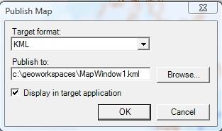
31 What is GeoMedia? Export and Publishing dgn GeoMedia GeoMedia Publishing Services dxf tif kml shp Google Earth
May 2012 Oracle Spatial User Conference
 1 May 2012 Oracle Spatial User Conference May 23, 2012 Ronald Reagan Building and International Trade Center Washington, DC USA Andrew Howles & Jo Shannon IS Principal Architect General Manager, Operations
Marushka Server. Product Specification
 Introductory Information Product Marushka Server represents a new generation of tools (devices) for publication and use of GIS data in the Internet and intranet. It is built on component technology in.net
Oracle Spatial Pure Web Editing for Telco Outside Plant Engineering Planning. Eamon Walsh espatial Solutions
 Spatial SIG Oracle Spatial Pure Web Editing for Telco Outside Plant Engineering Planning Eamon Walsh espatial Solutions Speaker Eamon Walsh, CTO espatial Solutions. over 20 years experience in the IT industry,
GEOMEDIA SMART CLIENT 2015 PRODUCT FEATURES AND COMPARISONS
 GEOMEDIA SMART CLIENT 2015 PRODUCT FEATURES AND COMPARISONS GeoMedia Smart Client enables the entire organization to access and utilize rich geospatial data in their business processes. It delivers an
MapInfo Professional Evolution!
 MapInfo Professional Evolution! A long history of improvement This presentation covers what is new in all of the MapInfo Pro releases since v9.0! MapInfo Pro Release History A feature release every year
ArcGIS 9.2 Works as a Complete System
 ArcGIS 9.2 Works as a Complete System A New Way to Manage and Disseminate Geographic Knowledge Author/Serve/Use Maps Data Models Globes Metadata Use Desktop Explorer Web Map Viewer Mobile Open APIs Enterprise
GEOMEDIA SMART CLIENT 2016
 PRODUCT DESCRIPTION GEOMEDIA SMART CLIENT 2016 PRODUCT FEATURES AND COMPARISONS GeoMedia Smart Client enables the entire organization to access and utilize rich geospatial data in their business processes.
San José Implementing GIS the Spatial Way. Addressing compliance, security, scalability, interoperability and open standards for business needs
 San José Implementing GIS the Spatial Way Addressing compliance, security, scalability, interoperability and open standards for business needs Overview Key Strategy & Requirements Building on Previous
Copyright 2012, Oracle and/or its affiliates. All rights reserved.
 1 Real Life Applications of Location Analytics Dan Geringer, Senior Software Development Manager, Oracle Jayant Sharma, Director Prod Mgmt, Oracle 2 The following is intended to outline our general product
Mike Horsfall Technical Manager GeoSpatial Sales
 An Introduction to Bentley Utilities Designer Mike Horsfall Technical Manager GeoSpatial Sales What is Bentley Utilities Designer? Bentley Utilities Designer is: A multi-utilities desktop GIS Built on
Introduction to Geodatabase and Spatial Management in ArcGIS. Craig Gillgrass Esri
 Introduction to Geodatabase and Spatial Management in ArcGIS Craig Gillgrass Esri Session Path The Geodatabase - What is it? - Why use it? - What types are there? - What can I do with it? Query Layers
Establishing a Geospatial EnvironmentChapter1:
 Chapter 1 Establishing a Geospatial EnvironmentChapter1: The lessons in this chapter describe working with the SDF format, and feature sources such as raster and ODBC points. Feature sources can be both
THE GEOMEDIA ARCHITECTURE ADVANTAGE
 THE GEOMEDIA ARCHITECTURE ADVANTAGE White Paper April 04, 2014 Contents 1. Introduction... 3 2. GeoMedia Overview... 3 3. The GeoMedia Architecture Advantage... 3 3.1 GeoMedia Data Servers... 4 3.2 Geographic
Accessing Data Where it Lives
 Accessing Data Where it Lives Session 3A Steve Carr TSI Tyson Haverkort Safe Software Session Description We ll discuss many types of data that can be used in MapInfo Professional such as: Business Data
Digging Into Autodesk Map 3D 2007 Level 1 Training Rick Ellis Michael Carris Russell Martin
 Digging Into Autodesk Map 3D 2007 Level 1 Training Rick Ellis Michael Carris Russell Martin PO Box 344 Canby Oregon 97013 www.cadapult-software.com training@cadapult-software.com (503) 829-8929 Table of
May 22, 2013 Ronald Reagan Building and International Trade Center Washington, DC USA
 May 22, 2013 Ronald Reagan Building and International Trade Center Washington, DC USA Scott Gooding Spatial Database Architect CSX Rail: Implementation of Oracle s Spatial Routing, Geocoding, LRS and NDM
Feature Enhancements by Release
 Autodesk Map Feature Enhancements by Release This document highlights the feature enhancements that have occurred with each release of Autodesk Map software from Release 4 (2000i) through the current 2004
CONCOCTING A GIS. Designing a Geodatabase Optimized for Data Maintenance and Map Production
 CONCOCTING A GIS Designing a Geodatabase Optimized for Data Maintenance and Map Production Jim Isbell Engineering Tech. II Kern County Assessor s Office KERN COUNTY STATISTICS Size of Kern County 8,162
GIS Fundamentals: Supplementary Lessons with ArcGIS Pro
 Station Analysis (parts 1 & 2) What You ll Learn: - Practice various skills using ArcMap. - Combining parcels, land use, impervious surface, and elevation data to calculate suitabilities for various uses
May 2012 Oracle Spatial User Conference
 1 May 2012 Oracle Spatial User Conference May 23, 2012 Ronald Reagan Building and International Trade Center Washington, DC USA Siva Ravada Director of Development Oracle Spatial Steve MacCabe Product
Oracle Hyperion Financial Management Instructor-led Live Online Training Program
 1. Introduction to Financial Management About Oracle's Enterprise Performance Management Suite Financial Management Solution Financial Consolidation, Reporting, Analysis and Product Components Financial
BROWSER. LuciadRIA DATA SHEET
 BROWSER LuciadRIA DATA SHEET V2017 V2017.0 DATA SHEET LuciadRIA is the answer to today s demands for powerful, lightweight applications in the browser. Driven by today s most advanced web technologies,
Municipal Parcel Mapping Workshop
 Municipal Parcel Mapping Workshop Presented to: Ontario Municipalities Presented by: Dave Gariepy, Director of Platform Content Dave Horwood, Land Information Systems Architect Sarah Sibbett, Senior Parcel
Providing Interoperability Using the Open GeoServices REST Specification
 2013 Esri International User Conference July 8 12, 2013 San Diego, California Technical Workshop Providing Interoperability Using the Open GeoServices REST Specification Satish Sankaran Kevin Sigwart What
PlaceMap. Accommodation. Slide 1
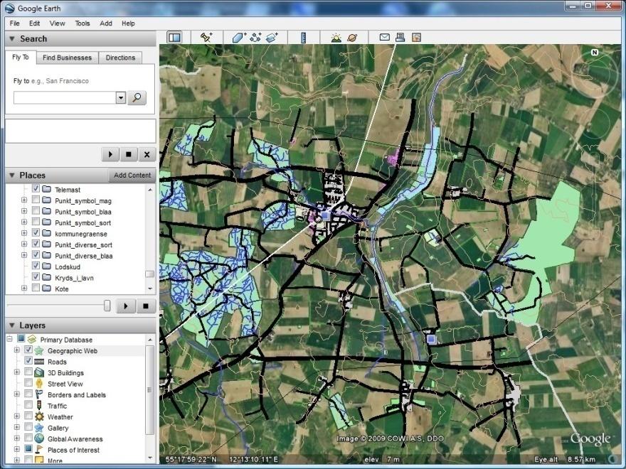
 PlaceMap for Accommodation Slide 1 PlaceMap Using the power of Google Earth to store and display all of your spatial data in a much more dynamic way Google Earth is a free software program that lets you
May 21, 2014 Walter E. Washington Convention Center Washington, DC USA. Copyright 2014, Oracle and/or its affiliates. All rights reserved.
 May 21, 2014 Walter E. Washington Convention Center Washington, DC USA 1 Innovation in Spatial Data Processing Hans Viehmann Product Manager EMEA The following is intended to outline our general product
May 21, 2014 Walter E. Washington Convention Center Washington, DC USA. Copyright 2014, Oracle and/or its affiliates. All rights reserved.
 May 21, 2014 Walter E. Washington Convention Center Washington, DC USA 1 How to Build a Better GIS Application Siva Ravada Senior Director of Development Spatial and Graph & MapViewer Oracle Program Agenda
Schema transformations in mass data harmonization process. Yohann Ly 8/9 Octobre 2013 Marne la Vallée
 Schema transformations in mass data harmonization process Yohann Ly 8/9 Octobre 2013 Marne la Vallée Mass data harmonization process Problematic : Multiple data providers Multiple storage format Multiple
GISCI GEOSPATIAL CORE TECHNICAL KNOWLEDGE EXAM CANDIDATE MANUAL AUGUST 2017
 GISCI GEOSPATIAL CORE TECHNICAL KNOWLEDGE EXAM CANDIDATE MANUAL AUGUST 2017 This document provides information about the GISCI Geospatial Core Technical Knowledge Exam, now a requirement for GISCI GISP
May 22, 2013 Ronald Reagan Building and International Trade Center Washington, DC USA
 May 22, 2013 Ronald Reagan Building and International Trade Center Washington, DC USA 1 To 9. D 1. 2. 3. Performance, Performance, Performance What You Need To Know About Exadata Daniel Geringer Senior
Working with Scientific Data in ArcGIS Platform
 Working with Scientific Data in ArcGIS Platform Sudhir Raj Shrestha sshrestha@esri.com Hong Xu hxu@esri.com Esri User Conference, San Diego, CA. July 11, 2017 What we will cover today Scientific Multidimensional
Extend GIS. The Reach. Of Your GIS. Chris Cappelli Nathan Bennett
 Extend The Reach GIS Of Your GIS Chris Cappelli Nathan Bennett Where do your co-workers, managers, customers, and citizens go when they want to find or make a map? GIS is a practical system for problem
Advanced Standard Basic Notes
 9.3 Functionality Matrix Data Management Scalable Geodatabase Access Full Geodatabase Support Create Geodatabases Load Spatial Data into Geodatabases Manage Geodatabases One-Way Replication Two-Way Replication
GEOSPATIAL ERDAS APOLLO. Your Geospatial Business System for Managing and Serving Information
 GEOSPATIAL ERDAS APOLLO Your Geospatial Business System for Managing and Serving Information ERDAS APOLLO Do you have large volumes of data, a geographicallydistributed user base and rapidly changing
GASWorkS Product Description
 GASWorkS v10 Description: 1 GASWorkS Product Description GASWorkS has continued to evolve since our first quite simple but effective version of the software was released in 1991. Our latest release sports
Leveraging OGC Standards on ArcGIS Server
 Leveraging OGC Standards on ArcGIS Server Satish Sankaran Interoperability and Standards Team James Michel III ESRI Intel Team ArcGIS Server Complete Interoperable Server-Based GIS Desktop Explorer Web
Oracle Spatial Technologies: An Update. Xavier Lopez Director, Spatial Technologies Oracle Corporation
 Oracle Spatial Technologies: An Update Xavier Lopez Director, Spatial Technologies Oracle Corporation Overview Oracle Approach to Market Specialist v. Generalist Solutions New Developments: Oracle Database
Using ESRI data in Autodesk ISD Products
 GI13-3 Using ESRI data in Autodesk ISD Products 1.5 hr. Class 02-Dec-03 3:30pm - 5:00pm Session Description: We will focus on using data in a variety of ESRI formats within the Autodesk GIS product line,
May 2012 Oracle Spatial User Conference
 1 May 2012 Oracle Spatial User Conference May 23, 2012 Ronald Reagan Building and International Trade Center Washington, DC USA Daniel Geringer Senior Software Development Manager Oracle s Spatial Technologies
Kane County GIS-Technologies Management Solutions. DGN to SDE and Back Again
 Kane County Management Solutions nicoskithomas@co.kane.il.us 1 In the Beginning DGN Kane County, Illinois Supervisor of Assessments Bears Win Superbowl XX Intergraph IGDS Software Graphic Workstations
Features and Benefits
 AutoCAD Map 3D 2010 Features and Benefits AutoCAD Map 3D software is a leading engineering solution for creating and managing spatial data. Using open-source Feature Data Object (FDO) technology, AutoCAD
Basic MicroStation Training Outline
 12:30 DAY 1 Equipment Review Workstation, monitor, keyboard File server, Plot server, STATE server Drive Assignments Shortcut Menu General overview of commands Explorer Managing Folders & Files MicroStation
Review of Cartographic Data Types and Data Models
 Review of Cartographic Data Types and Data Models GIS Data Models Raster Versus Vector in GIS Analysis Fundamental element used to represent spatial features: Raster: pixel or grid cell. Vector: x,y coordinate
ArcGIS 10.1 for Desktop Artie Robinson
 ArcGIS 10.1 for Desktop Artie Robinson ArcGIS A Complete System for Geographic Information Cloud Web Online Mobile Enterprise Desktop Name Change Name Prior to 10.1 ArcGIS Desktop ArcInfo ArcEditor ArcView
Hyperion Interactive Reporting Reports & Dashboards Essentials
 Oracle University Contact Us: +27 (0)11 319-4111 Hyperion Interactive Reporting 11.1.1 Reports & Dashboards Essentials Duration: 5 Days What you will learn The first part of this course focuses on two
To Current And Beyond: Highlights of Virginia Beach s 10.2 Upgrade And ArcGIS Online Implementation From A Systems Analyst Perspective
 To Current And Beyond: Highlights of Virginia Beach s 10.2 Upgrade And ArcGIS Online Implementation From A Systems Analyst Perspective Dave Arnold, Systems Analyst Sridhar Katragadda, Systems Analyst Objective
Overview of ArcGIS Online Applications. Champaign County
 Overview of ArcGIS Online Applications Champaign County Champaign County GIS Consortium Updated: April 2017 Table of Contents ArcGIS Online Application Overview... 3 Map Interface Symbology and Terminology...
Vector-Based GIS Data Processing. Chapter 6
 Vector-Based GIS Data Processing Chapter 6 Vector Data Model Feature Classes points lines polygons Layers limited to one class of data Figure p. 186 Vector Data Model Shapefiles ArcView non-topological
Georeferencing. Georeferencing: = linking a layer or dataset with spatial coordinates. Registration: = lining up layers with each other
 Georeferencing How do we make sure all our data layers line up? Georeferencing: = linking a layer or dataset with spatial coordinates Registration: = lining up layers with each other Rectification: The
City of La Crosse Online Mapping Website Help Document
 City of La Crosse Online Mapping Website Help Document This document was created to assist in using the new City of La Crosse online mapping sites. When the website is first opened, a map showing the City
Using Autodesk Map Capabilities in Autodesk Civil 3D
 11/30/2005-1:00 pm - 2:30 pm Room:Swan 2 (Swan) Walt Disney World Swan and Dolphin Resort Orlando, Florida Using Autodesk Map Capabilities in Autodesk Civil 3D Neil Brooker - Autodesk CV33-3 This class
Using the Geodatabase
 Using the Geodatabase February 13, 2002 Presented by: John Stroud, ESRI GeoDatabase Geodatabase comes in two flavors Personal mdb format ArcSDE rdbms format ArcGIS is a suite of three products ArcView,
Network Assessor Overview HECO Integrated Grid Symposium - November 16, 2017
 Network Assessor Overview HECO Integrated Grid Symposium - November 16, 2017 1 About Kevala Delivers data and actionable intelligence for planning and operations, not control. Provides services to all
Managing Image Data on the ArcGIS Platform Options and Recommended Approaches
 Managing Image Data on the ArcGIS Platform Options and Recommended Approaches Peter Becker Petroleum requirements for imagery and raster Traditional solutions and issues Overview of ArcGIS imaging capabilities
Frequently Asked Questions for GeoMedia 3D Customers
 Frequently Asked Questions for GeoMedia 3D Customers Version 2, January 4, 2011 1. Q: What is Intergraph GeoMedia 3D? A: Intergraph s GeoMedia 3D provides 3D enablement for the GeoMedia desktop. However,
Leveraging Oracle Spatial
 Leveraging Oracle Spatial At Queensland Department Of Main Roads 000 000 David Jerrard GIS Developer Overview Scene Setting Queensland Department of Main Roads (MR) It s a big place! Oracle within MR ARMIS
Mississippi DOT's Approach to an Enterprise Wide Linear Referencing System
 Mississippi DOT's Approach to an Enterprise Wide Linear Referencing System Michael Cresap, Mississippi Department of Transportation Bruce Aquila, Intergraph Corporation Concurrent Session 3.4, State LRS
What s New in Desktop 10.1
 What s New in Desktop 10.1 Damian Spangrud Esri Redlands Trip Down Memory Lane ArcGIS A Complete System for Geographic Information Cloud Web Online Mobile Enterprise Desktop Sharing Information sharing
May 2012 Oracle Spatial User Conference
 1 May 2012 Oracle Spatial User Conference May 23, 2012 Ronald Reagan Building and International Trade Center Washington, DC USA Michele Sacchi Bridge Consulting Program Manager Geomarketing Analysis A
Image Services for Elevation Data
 Image Services for Elevation Data Peter Becker Need for Elevation Using Image Services for Elevation Data sources Creating Elevation Service Requirement: GIS and Imagery, Integrated and Accessible Field
1Z0-526
 1Z0-526 Passing Score: 800 Time Limit: 4 min Exam A QUESTION 1 ABC's Database administrator has divided its region table into several tables so that the west region is in one table and all the other regions
Using Databases for 3D Data Management From Point Cloud to City Model
 Using Databases for 3D Data Management From Point Cloud to City Model Hans Viehmann 1 1 ORACLE Corporation, Server Technologies Division, Hamburg, Germany, hans.viehmann@oracle.com Abstract With the cost
Montana Department of Transportation (MDT) Location/Linear Referencing System (LLRS) Design Process
 Location/Linear Referencing System (LLRS) Design Process") Montana Department of Transportation (MDT) Location/Linear Referencing System (LLRS) Design Process Marlin Sander, MDT and Bill Schuman, GeoDecisions Session Outline Current MDT s transportation inventory
Montana Department of Transportation (MDT) Location/Linear Referencing System (LLRS) Design Process Marlin Sander, MDT and Bill Schuman, GeoDecisions Session Outline Current MDT s transportation inventory
Scientific and Multidimensional Raster Support in ArcGIS
 Scientific and Multidimensional Raster Support in ArcGIS Sudhir Raj Shrestha sshrestha@esri.com Brief breakdown Scientific Multidimensional data Ingesting Scientific MultiDim Data in ArcGIS Ingesting and
_ LUCIADRIA V PRODUCT DATA SHEET _ LUCIADRIA PRODUCT DATA SHEET
 _ LUCIADRIA PRODUCT DATA SHEET V2016 LuciadRIA offers browser-based geospatial situational awareness with the fluidity and speed of a desktop application. The software components of LuciadRIA have been
What s New in ArcGIS Server 10
 What s New in ArcGIS Server 10 Derek Law ArcGIS Server Product Management What s s new in ArcGIS Server 10? Agenda Highlights: Enhanced Web mapping More powerful server-based analysis Geo-collaboration
Oracle 10g GeoSpatial Technologies. Eve Kleiman Asia/Pacific Spatial Product Manager Oracle Corporation
 Oracle 10g GeoSpatial Technologies Eve Kleiman Asia/Pacific Spatial Product Manager Oracle Corporation Eve.Kleiman@oracle.com Agenda Market and Technology Trends Oracle GeoSpatial Technology Stack What
Topics in this section How to use this book Understanding DWG objects and GIS features Other learning resources Complete list of animations
 What are GIS Skills? Many engineers are familiar with the powerful set of editing tools provided by AutoCAD, but have little experience with GIS applications and little time to learn them. If you have
PUBLIC WORKS. 1oo. DiEital Fee Schedules. Effective January 1, 2008
 PUBLIC WORKS Geographic Information Systems DiEital Fee Schedules Effective January 1, 2008 Date Advertised 12103/07 In (Publication) Daily Business Journal Public Hearing Date Approved as to form: David
Assimilating GIS-Based Voter Districting Processes in Maricopa County, Arizona
 Assimilating GIS-Based Voter Districting Processes in Maricopa County, Arizona Tim Johnson Geographic Information Systems Manager Maricopa County Recorder/Elections Department Abstract Accurate district
Digging Into Autodesk Map 3D 2005 Level 1 Training Rick Ellis Michael Carris Russell Martin
 Digging Into Autodesk Map 3D 2005 Level 1 Training Rick Ellis Michael Carris Russell Martin PO Box 344 Canby Oregon 97013 www.cadapult-software.com training@cadapult-software.com (503) 829-8929 Copyright
Training courses. Course Overview Details Audience Duration. Applying GIS
 Training courses (Last update: December 2017) Remarks: As part of a course a certificate is issued for each attendee. All software used during the courses is Open Source Software. Contact: allspatial Geospatial
How Iowa DOT is using its Linear Referencing System. Eric Abrams Spatial Coordinator Iowa DOT Gis.iowadot.gov
 How Iowa DOT is using its Linear Referencing System Eric Abrams Spatial Coordinator Iowa DOT Gis.iowadot.gov Eric.abrams@dot.iowa.gov Linear Referencing System A set of procedures and methods for specifying
AutoCAD Map 3D and ESRI ArcSDE
 AUTOCAD MAP 3D 2009 WHITE PAPER AutoCAD Map 3D and ESRI ArcSDE Many organizations, such as utilities, telecommunication providers, and government agencies, depend on geospatial data that is stored in a
REDI 5.0 User Manual
 REDI 5.0 User Manual OBJECTIVE: REDI (Regional Economic Development Information System) provides a quick, convenient and easy way of accessing the City of San Diego Business Incentive Zones (BIZ) information.
Esri Production Mapping An Introduction
 Esri International User Conference San Diego, California Technical Workshops July 25, 2012 Esri Production Mapping An Introduction Lana Tylka Amber Bethell Workshop Overview Part I - Industry challenges
Setting Up and Deploying Geospatial Data Shares Using the QGIS Server Application
 Setting Up and Deploying Geospatial Data Shares Using the QGIS Server Application Donald L. Schrupp Wildlife Ecologist Colorado Division of Wildlife (retired) Quantum GIS (QGIS) Applications QGIS is not
OPEN SOURCE SOLUTIONS FOR SURVEYORS
 2 nd Sabah International Surveyors Congress 11 th 12 th March 2014 OPEN SOURCE SOLUTIONS FOR SURVEYORS Presented By : Sr Alexander Chong Director, Jurukur Antarabangsa The Benefits Of Closed Proprietary
The City of Huntsville, Texas GIS Mapping System
 The City of Huntsville, Texas GIS Mapping System Author: Huntsville, Texas GIS Division GIS DATA & MAP DISCLAIMER: The City of Huntsville, Texas shall not be held liable for improper or incorrect use of
Hyperion Financial Management Course Content:35-40hours
 Hyperion Financial Management Course Content:35-40hours Course Outline Introduction to Financial Management About Enterprise Performance Management Financial Management Solution Financial Consolidation,
Working with Feature Layers. Russell Brennan Gary MacDougall
 Working with Feature Layers Russell Brennan Gary MacDougall Working with Feature Layers Session will focus on feature access and editing Highlight new features added over the last few releases Agenda Introduction
What s New in ecognition 9.0. Christian Weise
 What s New in ecognition 9.0 Christian Weise Presenting ecognition 9 Release Date: March 2014 Who s eligible? All user with a valid ecognition maintenance contract Presenting ecognition 9 ecognition version
Location Intelligence Geographic Information Systems. MapInfo Pro evolution Latest release adds to a long line of enhanced capabilities
 Location Intelligence Geographic Information Systems MapInfo Pro evolution Latest release adds to a long line of enhanced capabilities Step up to our latest GIS. As the need for spatial analytics grows,
Organizing Design Data
 Organizing Design Data Module Overview This module explains how to use the data in different files for reference purposes. Module Prerequisites Knowledge of MicroStation s interface Some knowledge about
IT Infrastructure for BIM and GIS 3D Data, Semantics, and Workflows
 IT Infrastructure for BIM and GIS 3D Data, Semantics, and Workflows Hans Viehmann Product Manager EMEA ORACLE Corporation November 23, 2017 @SpatialHannes Safe Harbor Statement The following is intended
2011 Bentley Systems, Incorporated. Bentley Descartes V8i Advancing Information Modeling For Intelligent Infrastructure
 Bentley Descartes V8i Advancing Information Modeling For Intelligent Infrastructure Agenda Why would you need Bentley Descartes? What is Bentley Descartes? Advanced Point Cloud Workflows Advanced Terrain
Manitowoc County, WI Advanced Access GIS Viewer User Documentation
 Manitowoc County, WI Advanced Access GIS Viewer User Documentation Introduction Extensive time was put into developing this website both from a display, and from a printing and scaling perspective. This
GIS Data Collection. This chapter reviews the main methods of GIS data capture and transfer and introduces key practical management issues.
 9 GIS Data Collection OVERVIEW This chapter reviews the main methods of GIS data capture and transfer and introduces key practical management issues. It distinguishes between primary (direct measurement)
ArcMap - EXPLORING THE DATABASE Part I. SPATIAL DATA FORMATS Part II
 Week 5 ArcMap - EXPLORING THE DATABASE Part I SPATIAL DATA FORMATS Part II topics of the week Exploring the Database More on the Table of Contents Exploration tools Identify, Find, Measure, Map tips, Hyperlink,
MapInfo Pro. Version 17 Overview
 MapInfo Pro tm Version 17 Overview 1 Disclaimers & Notes Most of what you ll see is a Work in Progress There will be some bugs and incomplete functionality Some things being shown are not yet available
The Oracle Enterprise Geodatabase (EGDB) Charlie Crocker Farallon Geographics, Inc.
 Charlie Crocker Farallon Geographics, Inc.") The Oracle Enterprise Geodatabase (EGDB) Charlie Crocker Farallon Geographics, Inc. www.fargeo.com Norcal URISA Chapter Meeting 2/9/2005 Todays Goals Enterprise geodatabase defined Roles Oracle can play
The Oracle Enterprise Geodatabase (EGDB) Charlie Crocker Farallon Geographics, Inc. www.fargeo.com Norcal URISA Chapter Meeting 2/9/2005 Todays Goals Enterprise geodatabase defined Roles Oracle can play
GEOSPATIAL ENGINEERING COMPETENCIES. Geographic Information Science
 GEOSPATIAL ENGINEERING COMPETENCIES Geographic Information Science The character and structure of spatial information, its methods of capture, organisation, classification, qualification, analysis, management,
Autodesk Utility Design and Your GIS
 UT4523-P Autodesk Utility Design and Your GIS Prashant Srivastav Quality Assurance Lead, Utilities Co Speakers: Jeff Saunders, Carsten Hess The Power Track Utility Design Power Track at a glance... and
DEVELOPING A NEW GEOGRAPHICAL OBJECT DATABASE. EXPERIENCES FROM IDEA TO DELIVERING DATASETS TOP10NL
 DEVELOPING A NEW GEOGRAPHICAL OBJECT DATABASE. EXPERIENCES FROM IDEA TO DELIVERING DATASETS TOP10NL NICO J. BAKKER Topografische Dienst Kadaster Bendienplein 5 7815 SM Emmen, The Netherlands nbakker@tdkadaster.nl
Coastal Adaptation to Sea Level Rise Tool (COAST)
") Built on the Global Mapper SDK Coastal Adaptation to Sea Level Rise Tool (COAST) Tutorial v3.0 4/8/2015 Table of Contents Introduction... 3 COAST Scenario Data Requirements... 3 Setting Up a COAST Scenario...
Built on the Global Mapper SDK Coastal Adaptation to Sea Level Rise Tool (COAST) Tutorial v3.0 4/8/2015 Table of Contents Introduction... 3 COAST Scenario Data Requirements... 3 Setting Up a COAST Scenario...
Croatian Motorways Road Database Management System
 Croatian Motorways Road Database Management System Marko Turković FOSS4G-Europe 2014 Presentation overview About us System introduction System component architecture Kosmo Desktop WebGIS portal Future
GE1LC7 - Getting to Know Bentley Descartes for Advanced Image Viewing, Editing and Processing
 GE1LC7 - Getting to Know Bentley Descartes for Advanced Image Viewing, Editing and Processing Inga Morozoff Introduction: Raster data is everywhere - whether you do CAD design, mapping or GIS analysis,
Announcements. Data Sources a list of data files and their sources, an example of what I am looking for:
 Data Announcements Data Sources a list of data files and their sources, an example of what I am looking for: Source Map of Bangor MEGIS NG911 road file for Bangor MEGIS Tax maps for Bangor City Hall, may
Carlson GIS for Surveyors
 Professional Land Surveyors of Ohio 2016 Annual Conference -- Dayton Ohio Carlson GIS for Surveyors Presented by Who Is That CAD Girl? Jennifer DiBona is a long time CAD consultant and trainer doing business
CityMap SDK: Assembling Web Services into a Batch Geocoding Application
 CityMap SDK: Assembling Web Services into a Batch Geocoding Application Avencia Incorporated James Querry City of Philadelphia Objectives 1. Why web services? 2. Which services were useful? 3. How can