Aerosol retrieval using polarimetric observations: THEORY and PRACTICE. What users should expect from polarization?
|
|
|
- Gerard Summers
- 5 years ago
- Views:
Transcription


1 Aerosol retrieval using polarimetric observations: THEORY and PRACTICE What users should expect from polarization? GRASP O. Dubovik1, P. Litvinov1, D. Tanré1, T. Lapyonok1, A. Fedorenko1, A. Lopatin1, F. Ducos1, M. Spetsberger2, A. Coman2, W. Planer2, C. Federspiel2 1- University of Lille 1, CNRS, France 2 - Catalysts GmbH, High Performance Computing, Linz, Austria Sensitivity of polarization to aerosol; Advantages and possible challenges; GRASP algorithm; PARASOL retrievals reality, potential ICAP working group meeting, 5-8 November, 2013, Tsukuba, Japan
 POLARIZATION: N P l=3: (0.49, 0.67, 0.865 mm) AERONET New generation of Cimel multi-spectral polarimeters VIEWS: N Q = ~ 30: (2 0 Q 150 0 ) INTENSITY + POLARIZATION: N l =8: (0.34, 0.38, 0.")
2 POLDER Available measurements of polarization: GLOBAL: every 2 days SPATIAL RESOLUTION: 5.3km 6.2km VIEWS: N Q = 16: (80 0 Q ) INTENSITY: N t l=6: (0.44, 0.49, 0.56, 0.67, 0.865, 1.02 mm) POLARIZATION: N P l=3: (0.49, 0.67, mm) AERONET New generation of Cimel multi-spectral polarimeters VIEWS: N Q = ~ 30: (2 0 Q ) INTENSITY + POLARIZATION: N l =8: (0.34, 0.38, 0.44, 0.50, 0.67, 0.87, 1.02, 1.64 mm) lidar Multi-spectral backscattering and depolarization profiles VIEWS: N Q = 1: (Q = ) INTENSITY backscattering profiles : N t l= ~ 3: (0.355, 0.532, mm) DEPOLARIZATION profiles : N P l=1: (0.532 mm)
3 SINDLE SCATTERING What polarization may add? OPTIMISTIC view P 11 - characterizes intensity, P 12, P 22, P 33, P 34, P 44 - characterize state of polarization add sensitivity to all aerosol properties (size, shape, absorption, refraction) MULTIPLE SCATTERING 1.Polarization of land surface is very weak, spectrally neutral and quite homogeneous; add sensitivity to aerosol over bright land surfaces 2. Molecular scattering strongly polarizes scatted light and it vertically very stable; add sensitivity to aerosol vertical distribution (in passive observations)
4 Accounting for polarization in radiation transmitted through the atmospheric Total: I Q;l = m 0 exp m 0 exp m 1 m 0 m 1 L 1 ; L 2 - rotation matrices 0 L 2 P Q;l L 1 I 0 mult. scat. I = I Q U V - Stokes vector F(Q;l) = F 11 F F 12 F F 33 F F 34 F 44 phase matrix!!! 1 0 I 0 = 0 0 I Q;l ~ 0 F 11 Q;l mult. scat. P Q;l ~ - F 12 Q;l /F 11 Q;l mult. scat. - Intensity -Linear Polarization
5 Phase Function Degree of Linear Plarization (-F 12 /F 11 ) Sensitivity of to particle size Log-normal monomodal dv(r)/dlnr : s v = 0.5, m = 0.44 mm, n = 1.4, k = SPHERES Rv = 0.1 Rv = 0.12 Rv = 0.14 Rv = 0.2 Rv = 0.4 Rv = 0.6 Rv = 1.0 Rv = 2.0 Rv = SPHERES Rv = 0.1 Rv = 0.12 Rv = 0.14 Rv = 0.2 Rv = 0.4 Rv = 0.6 Rv = 1.0 Rv = 2.0 Rv = Scattering Angle ( degrees) Scattering Angle ( degrees)
6 Spheres Sensitivity to real part of refractive index for fine mode aerosol Log-normal monomodal dv(r)/dlnr : s v = 0.5, m = 0.44 mm, k = 0.005

/dlnr : s v = 0.5, m = 0.")
7 Spheres Sensitivity to to real part of refractive index for coarse mode aerosol Log-normal monomodal dv(r)/dlnr : s v = 0.5, m = 0.44 mm, k = 0.005

8 Real aerosol Modeled spherical: Randomly oriented spheroids : AERONET model
9 Degree of Linear Plarization (-F 12 /F 11 ) Degree of Linear Plarization (-F 12 /F 11 ) Sensitivity of Linear Polarization to particle size Log-normal monomodal dv(r)/dlnr : s v = 0.5, m = 0.44 mm, n = 1.4, k = SPHERES Rv = 0.1 Rv = 0.12 Rv = 0.14 Rv = 0.2 Rv = 0.4 Rv = 0.6 Rv = 1.0 Rv = 2.0 Rv = SPHEROIDS Rv = 0.1 Rv = 0.12 Rv = 0.14 Rv = 0.2 Rv = 0.4 Rv = 0.6 Rv = 1.0 Rv = 2.0 Rv = Scattering Angle ( degrees) Scattering Angle ( degrees)
/dlnr : s v = 0.5, m = 0.")
10 Sensitivity of Linear Polarization of fine mode aerosol to real part of refractive index Log-normal monomodal dv(r)/dlnr : s v = 0.5, m = 0.44 mm, k = 0.005

11 Sensitivity of polarization to particle shape Coarse aerosol
12 What polarization may add? SINDLE SCATTERING P 12 - important for passive observation of polarization add sensitivity to - particle shape and - size distribution and real ref. index of small and large spherical particles COMPLICATIONS: particles can be inhomogeneous, and have very complex shape MULTIPLE SCATTERING 1.Polarization of land surface is very weak, spectrally neutral and quite homogeneous; add sensitivity to aerosol over bright land surfaces COMPLICATIONS: accurate modeling of surface polarization is complicated 2. Molecular scattering strongly polarizes scatted light and it vertically very stable; REALISTIC view add sensitivity to aerosol vertical distribution (in passive observations) COMPLICATIONS: accurate assumption of aerosol vertical properties is complicated
13 independent POLDER/PARASOL measurements : GLOBAL: every 2 days SPATIAL RESOLUTION: 5.3km 6.2km VIEWS: N Q = 16: (80 0 Q ) INTENSITY: N t l=6: (0.44, 0.49, 0.56, 0.67, 0.865, 1.02 mm) POLARIZATION: N P l=3: (0.49, 0.67, mm) SINGLE OBSERVATION: a lot!!! as much as AERONET N t l N P l N Q = (6+3) 16= 144


14 Present aerosol retrieval from PARASOL: Over Ocean (Herman et al., 2005): - Uses look-up tables - Fits both intensity and polarizations at 0.67 and 0.87 mm -Retrieves: AOT of fine and coarse mode, size information, nonsphericity, some height information. -Issues: does not always provide consistency with other channels Over Land (Deuzé et al., 2001): - Uses look-up tables - Fits only polarizations at 0.67 and 0.87 mm using look-up tables - Retrieves: AOT of fine mode only, some size information - Issues: quite limited
 polarimeter data did not result")

15 QUESTION: Why the PARASOL ( ) polarimeter data did not result in а great aerosol product until now? ALGORITM is not adequate???

16

17 GRASP objectives: Accurate, Versetile and Fast Inversion scheme: - search in continues space of solution; - optimization as Multi-term LSM; - simultaneous multi-pixel retrieval; GRASP Forward model: - applicable to diverse remote sensing observations; - accurate modeling using direct on-line computations; Software implementation: - advanced highly parralized CPU and GPU programinng; - public, open source aerosol retrieval code;


; n(l) and k(l) -")
 - spherical")

18 Smoke Desert Dust AERONET retrievals are driven by 31 variables : PARASOL: + surface BRDF+ aerosol height Particle Size Distribution: 0.05 mm R (22 bins) 15 mm dv/lnr - size distribution (22 values); n(l) and k(l) - ref. index (4 +4 values) C spher (%) - spherical fraction (1 value) Complex Refractive Index at l = 0.44; 0.67; 0.87; 1.02 mm Maritime


, 0 (l h),")


19 Forward Model Vector of retrieved parameters : a aer - aerosol properties GRASP Vertical distribution shape a aer a surf - surface properties a surf Aerosol single scattering Surface reflectance (l h), 0 (l h), P(l,Q h) BRDF BPDF Multiple scattering effects All calculations are on line!!! Radiative Transfer: F(l,Q ) Simulated observations:
20 Statistically Optimized Minimization Multi-Term LSM Dubovik and King 2000, Dubovik 2004, Dubovik et a Measurements: A priori restrictions consistency Indicator l, i f i f i x i weighting f i a f i x (N total - N x ) ˆ i i Lagrange multipliers 0 2 Radiances (ground/plane/space); - Pol. radiances (ground/plane/space); - (l) (e.g. AERONET); - b (l h lidar backscattering; Restrictions on derivatives of: - size distr. Variability; AERONET - n spectral variability; - k spectral variability; -their covariances (should depend on l and Q) -lognormal error distributions - BRDF and BPDF spectral variability; - C(h) vertical variability; Lidar Surface


 x X")
21 Time-Variability Constraints The concept of multi-pixel retrieval POLDER/PARASOL ( t 3 ; x ; y ) t ( t 2 ; x ; y ) z X ( t 1 ; x ; y ) x X X-Variability Constraints


22 GRASP: Generalized Retrieval of Aerosol and Surface Properties AERONET POLDER lidar AERONET laboratory MISR??? GRASP single scattering Surface BRDF, BPDF shape

23 Tests over dark surface («Blind» Test) Kokhanovsky, et al, The intercomparison of major satellite aerosol retrieval., Atmos. Meas. Tech., 3, , ICAP working group meeting, 5-8 November, 2013, Tsukuba, Japan
24 retrieved AOT retrieved AOT POLDER: LOA-2(Dubovik) algorithm (BRDF) nm 443nm 490nm 565nm 675nm 870nm 1020nm LOA nm 443nm 490nm 565nm 675nm 870nm 1020nm LOA reference AOT reference AOT Case 1 Case 2

25 retrieved AOT MSPI (JPL): I+Q Lambertian unknown surface nm 558nm 672nm 866nm MISR Case reference AOT
26 Conclusion from the numerical retrieval tests: Positive: GRASP provides rather accurate aerosol retrievals; Negative: GRASP is essentially slower than traditional aerosol algorithms; (originally ~ 10 sec per pixel) ICAP working group meeting, 5-8 November, 2013, Tsukuba, Japan
27 GRASP is too slow? Acceleration using GPU Overall Timing Trends Now: ~ 0.1 sec per pixel, it is not over CATALYSTS GMBH, LABORATOIRE D'OPTIQUE ATMOSPHÉRIQUE

28 GRASP Open Source Code distributed via web 28


29 Aerosol Retrieval LEGO? Game principles: - basic blocs are solid, easy to use, replaceable, can be connected in different combinations; - final construction is reliable. Benefits: - variety of applications; - different designs are possible; - testing of alternative basic blocks ; - testing various connections Results are better!!! Progress is faster!!!


30 GRASP Nephelometer Sun-photometer Diverse applications of GRASP Lidar AERONET PARASOL INVERSION INVERSION INVERSION Instrument design Instrument design Instrument design Aerosol (l h), 0 (l h),p(l,q h All modules are fully consistent!!! vertical profiles vertical profiles radiative transfer calculations
31 GRASP applications: GRASP Real Data: - PARASOL over land and ocean (CNES, ESA); - polar polarimeter - MERIS over land (ESA); - polar radiometer - AERONET+ lidar ( FP-7 Europe) - ground-based - airborne nephelometer (UMBC) - airborne Numerical test with perfect observations: - 3MI / EPS-SG ; - polar polarimeter - Sentinel 4 (GOCI real data ESA); - geostationary radiometer - MERIS, AATSR (ESA); - polar radiometer - MISR; - polar radiometer - GICOM project (JAXA); - polar bi-viewing polarimeter - CHINA GLORY + 3MI project - polar polarimeter
32 Comparison of PARASOL with AERONET Beiging Kanpur Banizoumbou Mongu In cooperation with ESA - CCI Banizoumbou: January, February, 2008 Surface: Grassland. Aerosol: Coarse mode is dominated. Mongu: August, September, 2008 Surface: Savanna. Aerosol: Fine mode is dominated. Beijing: April, December, 2008 Surface: Urban. Aerosol: Mixture of Fine and Coarse Kanpur: October-December, 2008 Surface: Urban. Aerosol: Mixture of Fine and Coarse The IGBP (International Geosphere Biosphere Program) land type specification was used
.")


33 Regional maps (1800 x 1800 km). Banizoumbou, AOD 670 nm Strong spatial and temporal variation of AOD


34 Regional maps (1800 x 1800 km). Banizoumbou, SSA 670 nm Essential temporal variation of SSA
. 21.02.2008 23.02.2008 Frascati March 12, 2013")
35 Daily variation of AOD and SSA at 670 nm. Banizoumbou (Jan., Febr. 2008) Frascati March 12, 2013
36 AOD. POLDER/AERONET
37 Angstrom Exponent. POLDER/AERONET Frascati March 12, 2013

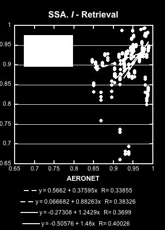
38 SSA. POLDER/AERONET
39 Importance of Polarization? Synthetic measurements simulation We simulated 2 months of PARASOL measurements Aerosol and surface properties and aerosol concentration are taken from the retrieval of PARASOL measurements over Banizoumbou in January, February ICAP working group meeting, 5-8 November, 2013, Tsukuba, Japan
40 Inversion of synthetic measurements Intensity + Polarization (I, Q, U) ICAP working group meeting, 5-8 November, 2013, Tsukuba, Japan
41 41


42 42
43 Inversion of synthetic measurements Intensity only (I) ICAP working group meeting, 5-8 November, 2013, Tsukuba, Japan


44 44


45 45
46 Inversion of synthetic measurements Polarization only (Q, U) ICAP working group meeting, 5-8 November, 2013, Tsukuba, Japan


47 47
48 48
49 Inversion of REAL PARASOL measurements Different Scenarios: I+Q+U; I; Q+U ICAP working group meeting, 5-8 November, 2013, Tsukuba, Japan


50 I,Q,U retrieval vs I-retrieval and Q,U-retrieval: AOD (Mongu. August, September 2008)


51 I,Q,U retrieval vs I-retrieval and Q,U-retrieval: SSA (Banizoumbou)


52 I,Q,U retrieval vs I-retrieval and Q,U-retrieval


53 I,Q,U retrieval vs I-retrieval and Q,U-retrieval: total reflectance fits ICAP working group meeting, 5-8 November, 2013, Tsukuba, Japan
54 Conclusion from the tests: Polarization is a great addition to multi-angular intensity observations ICAP working group meeting, 5-8 November, 2013, Tsukuba, Japan
55 Differences in Radiances (%) Differences in Radiances (%) PARASOL observations under correction by CNES now Spectral changes in radiances Banizoumbou Mongu Changes in Radiances Banizoumbou, February, 2008 Changes in Radiances Banizoumbou, February, Scattering Angle 175 Scattering Angle Scattering Angle 115 Scattering Angle Wav elenght (mm) Wav elenght (mm)
56 Radiances (I( Q)/I 0 ) Radiances (I( Q)/I 0 ) Radiances (I( Q)/I 0 ) Radiances (I( Q)/I 0 ) Radiances (I( Q)/I 0 ) Radiances (I( Q)/I 0 ) Changes in radiances PARASOL Spectral Radiances Banizoumbou, February, 2008 PARASOL Spectral Radiances Banizoumbou, February, 2008 PARASOL Spectral Radiances Banizoumbou, February, ORIGINAL 440 NEW ORIGINAL 670 NEW ORIGINAL 1020 NEW Scattering angle (degree) PARASOL Spectral Radiances Banizoumbou, February, Scattering angle (degree) Fit of new radiances PARASOL Spectral Radiances Banizoumbou, February, Scattering angle (degree) PARASOL Spectral Radiances Banizoumbou, February, FIT 440 MES NEW FIT 670 MES NEW FIT 1020 MES NEW Scattering angle (degree) Scattering angle (degree) Scattering angle (degree)
57 0.44), PARASOL 0.44), PARASOL Changes in retrieved AOD (440) - DUST Banizoumbou (original) Banizoumbou ( new ) PARASOL v ersus AERONET (original) Banizoumbou, January - February, 2008 PARASOL v ersus AERONET (new ) Banizoumbou, January - February, y = x R= y = x R= ), AERONET 0.44), AERONET
58 0.44), PARASOL 0.44), PARASOL Changes in retrieved AOD (440) (high loading) Mongu ( original ) Mongu ( new ) PARASOL versus AERONET (original) Mongu, August - September, 2008 PARASOL versus AERONET (original) Mongu, August - September, y = x R= y = x R= ), AERONET 0.44), AERONET
59 0 (0.44), PARASOL 0 (0.44), PARASOL Changes in retrieved SSA (440) BIOMAS BURNING (high loading) Mongu (original) Mongu ( new ) PARASOL v ersus AERONET (original) Mongu, August - September, 2008 (0.44) > PARASOL v ersus AERONET (original) Mongu, August - September, 2008 (0.44) > y = x R= y = x R= (0.44), AERONET (0.44), AERONET
60 PARASOL (GRASP algorithm) 0 (l), PARASOL Changes in retrieved SSA (4wl) (high loading) 4 sites ( original ) Mongu + Banizoumbou ( new ) SSA (Ross-Li+Maignan model) PARASOL v ersus AERONET (new ) M ongu, August - September, 2008 Banizoumbou, January - February, 2008 (0.44) > Mongu Banizoumbou nm 670 nm 865 nm 1020 nm AERONET y = x R= (l), AERONET 0 y = x R= y = x R= y = x R= y = x R=
61 GRASP retrieval. Regional maps (1800 x 1800 km). Europe, SALB 670 and 865 nm Big contrast between 670 and 865 nm because of vegetation!!!

62 GRASP retrieval. Regional maps (1800 x 1800 km). Europe, AOD and SSA 670 nm Strong spatial variation of AOD and SSA

63 GRASP retrieval. Regional maps (1800 x 1800 km). Beijing, SSA 670 nm Strong spatial and temporal variation of SSA


64 GRASP retrieval. Regional maps (1800 x 1800 km). Mongu, SSA 670 nm NASA Global Fire Maps (detected by MODIS) Small SSA correspond to biomass burning!

65 Dubovik et al., AMT, 2011 GRASP Status: Software is our passion GRASP Core Algorithm is developed and performs well: - uses very elaborated aerosol and RT models; - inversion is based on rigorous statistical optimization; - performs well in numerical test (Dubovik et al. 2011, Kokhanovsky et al. 2010); - has a lot of flexibility - GRASP is under acceleration on GPU; - Cloud retrieval is to be integrated into GRASP; Promises: - Operational PARASOL aerosol product (SSA, etc.) in 2014; - Open Source GRASP code is to be available to a wide community; - Using GRASP for other sensors has some potential ICAP working group meeting, 5-8 November, 2013, Tsukuba, Japan
GRASP Algorithm: Retrieval of the detailed properties of atmospheric aerosol from PARASOL and other sensors
 GRASP Algorithm: Retrieval of the detailed properties of atmospheric aerosol from PARASOL and other sensors Oleg Dubovik (University of Lille-1, CNRS, France) GRASP team: P. Litvinov 1,T. Lapyonok 1, F.
SEOM s Sentinel-3/OLCI project CAWA: advanced GRASP aerosol retrieval
 SEOM s Sentinel-3/OLC project CAWA: advanced GRASP aerosol retrieval Oleg Dubovik1, Pavel Litvinov1, Xin Huang1, Michael Aspetsberger2, David Fuertes3, Carsten Brockmann4, And Jürgen Fischer5. 1- University
Aerosol Remote Sensing from PARASOL and the A-Train
 Aerosol Remote Sensing from PARASOL and the A-Train J.-F. Léon, D. Tanré, J.-L. Deuzé, M. Herman, P. Goloub, P. Lallart Laboratoire d Optique Atmosphérique, France A. Lifermann Centre National d Etudes
Algorithm development for aerosol retrieval and its validation based on combined use of polarization and radiance measurements
 Algorithm development for aerosol retrieval and its validation based on combined use of polarization and radiance measurements I. Sano, and CI team CIs : S. Mukai, M. Nakata, B. Holben, O. Dubovik, A.
Polarimetric remote sensing of atmospheric aerosols: POLDER and beyond
 Polarimetric remote sensing of atmospheric aerosols: POLDER and beyond Otto Hasekamp 1, Arjen Stap 1,2, Antonio di Noia 1, Jeroen Rietjens, Martijn Smit, Frans Snik 4, Pavel Litvinov 3, Arjan van Beelen
OMAERO README File. Overview. B. Veihelmann, J.P. Veefkind, KNMI. Last update: November 23, 2007
 OMAERO README File B. Veihelmann, J.P. Veefkind, KNMI Last update: November 23, 2007 Overview The OMAERO Level 2 data product contains aerosol characteristics such as aerosol optical thickness (AOT), aerosol
Aerosol Optical Depth Retrieval from Satellite Data in China. Professor Dr. Yong Xue
 Aerosol Optical Depth Retrieval from Satellite Data in China Professor Dr. Yong Xue Research Report Outline Multi-scale quantitative retrieval of Aerosol optical depth (AOD) over land Spatial resolution:
MERIS US Workshop. Vicarious Calibration Methods and Results. Steven Delwart
 MERIS US Workshop Vicarious Calibration Methods and Results Steven Delwart Presentation Overview Recent results 1. CNES methods Deserts, Sun Glint, Rayleigh Scattering 2. Inter-sensor Uyuni 3. MOBY-AAOT
Global and Regional Retrieval of Aerosol from MODIS
 Global and Regional Retrieval of Aerosol from MODIS Why study aerosols? CLIMATE VISIBILITY Presented to UMBC/NESDIS June 4, 24 Robert Levy, Lorraine Remer, Yoram Kaufman, Allen Chu, Russ Dickerson modis-atmos.gsfc.nasa.gov
Retrieval of Aerosol and Cloud Properties using the ATSR Dual and Single View algorithms
 Retrieval of Aerosol and Cloud Properties using the ATSR Dual and Single View algorithms Gerrit de Leeuw 1,2, Larisa Sogacheva 1, Pekka Kolmonen 1, Giulia Saponaro 1, Timo H. Virtanen 1, Edith Rodriguez
UV Remote Sensing of Volcanic Ash
 UV Remote Sensing of Volcanic Ash Kai Yang University of Maryland College Park WMO Inter-comparison of Satellite-based Volcanic Ash Retrieval Algorithms Workshop June 26 July 2, 2015, Madison, Wisconsin
Improved MODIS Aerosol Retrieval using Modified VIS/MIR Surface Albedo Ratio Over Urban Scenes
 Improved MODIS Aerosol Retrieval using Modified VIS/MIR Surface Albedo Ratio Over Urban Scenes Min Min Oo, Matthias Jerg, Yonghua Wu Barry Gross, Fred Moshary, Sam Ahmed Optical Remote Sensing Lab City
Evaluation of Satellite Ocean Color Data Using SIMBADA Radiometers
 Evaluation of Satellite Ocean Color Data Using SIMBADA Radiometers Robert Frouin Scripps Institution of Oceanography, la Jolla, California OCR-VC Workshop, 21 October 2010, Ispra, Italy The SIMBADA Project
Understanding The MODIS Aerosol Products
 Understanding The MODIS Aerosol Products Rich Kleidman Science Systems and Applications Rob Levy Science Systems and Applications Lorraine Remer NASA Goddard Space Flight Center Chistina Chu NASA Goddard
Using LiDAR for Classification and
 Using LiDAR for Classification and Recognition of Particulate Matter in the Atmosphere M. Elbakary, K. Iftekharuddin, and K. AFRIFA ECE Dept., Old Dominion University, Norfolk, VA Outline Goals of the
Aerosol profiling by combination of lidar and lunar/star-photometry
 Aerosol profiling by combination of lidar and lunar/star-photometry Lucas Alados Arboledas (Task 11.2), UGR CNR, CNRS, UGR, UNIVLEEDS ACTRIS-2 1 st WP3 Workshop Athens, Greece November 10-12, 2015 Task
GRASP/GARRLiC. Inversion methods for atmospheric profiling of advanced aerosol proper=es
 GRASP/GARRLiC Inversion methods for atmospheric profiling of advanced aerosol proper=es Aerosol remote sensing Active Passive Surface Aerosol Layer 1 Aerosol scattering Layer N Lidar Surface reflection
Data Mining Support for Aerosol Retrieval and Analysis:
 Data Mining Support for Aerosol Retrieval and Analysis: Our Approach and Preliminary Results Zoran Obradovic 1 joint work with Amy Braverman 2, Bo Han 1, Zhanqing Li 3, Yong Li 1, Kang Peng 1, Yilian Qin
Multi-sensors vicarious calibration activities at CNES
 Multi-sensors vicarious calibration activities at CNES Patrice Henry, Bertrand Fougnie June 11, 2013 CNES background in image quality monitoring of operational Earth observation systems Since the launch
Prototyping GOES-R Albedo Algorithm Based on MODIS Data Tao He a, Shunlin Liang a, Dongdong Wang a
 Prototyping GOES-R Albedo Algorithm Based on MODIS Data Tao He a, Shunlin Liang a, Dongdong Wang a a. Department of Geography, University of Maryland, College Park, USA Hongyi Wu b b. University of Electronic
Challenges with atmospheric corrections over Land
 Challenges with atmospheric corrections over Land Eric Vermote NASA GSFC Code 619 Eric.f.vermote@nasa.gov. A Land Climate Data Record Multi instrument/multi sensor Science Quality Data Records used to
IOCCG Calibration Workshop 30 October 2004, Fremantle, Australia. In-Flight Calibration of Satellite Ocean-Color Sensors
 IOCCG Calibration Workshop 30 October 2004, Fremantle, Australia In-Flight Calibration of Satellite Ocean-Color Sensors Purpose The purpose of the workshop was to review the calibration of ocean-color
Accuracy assessments of aerosol optical properties retrieved from. AERONET Sun and sky-radiance measurements.
 Accuracy assessments of aerosol optical properties retrieved from AERONET Sun and sky-radiance measurements. O. Dubovik (1,2), A. Smirnov (1,2), B. N. Holben (1), M. D. King (3), Y. J. Kaufman (4), T.
Retrievals of Profiles of Fine and Coarse Aerosols Using Lidar and Radiometric Space Measurements
 IEEE TRANSACTIONS ON GEOSCIENCE AND REMOTE SENSING, VOL. 41, NO. 8, AUGUST 2003 1743 Retrievals of Profiles of Fine and Coarse Aerosols Using Lidar and Radiometric Space Measurements Yoram J. Kaufman,
Calibration Techniques for NASA s Remote Sensing Ocean Color Sensors
 Calibration Techniques for NASA s Remote Sensing Ocean Color Sensors Gerhard Meister, Gene Eplee, Bryan Franz, Sean Bailey, Chuck McClain NASA Code 614.2 Ocean Biology Processing Group October 21st, 2010
Improvements to the SHDOM Radiative Transfer Modeling Package
 Improvements to the SHDOM Radiative Transfer Modeling Package K. F. Evans University of Colorado Boulder, Colorado W. J. Wiscombe National Aeronautics and Space Administration Goddard Space Flight Center
Motivation. Aerosol Retrieval Over Urban Areas with High Resolution Hyperspectral Sensors
 Motivation Aerosol etrieval Over Urban Areas with High esolution Hyperspectral Sensors Barry Gross (CCNY) Oluwatosin Ogunwuyi (Ugrad CCNY) Brian Cairns (NASA-GISS) Istvan Laszlo (NOAA-NESDIS) Aerosols
Retrieving aerosol microphysical properties. by Lidar-Radiometer Inversion Code (LIRIC) for different aerosol types
 for different aerosol types") PUBLICATIONS Journal of Geophysical Research: Atmospheres RESEARCH ARTICLE Key Points: Microphysical properties are retrieved with LIRIC from lidar and Sun photometer Uncertainties of LIRIC algorithm are
PUBLICATIONS Journal of Geophysical Research: Atmospheres RESEARCH ARTICLE Key Points: Microphysical properties are retrieved with LIRIC from lidar and Sun photometer Uncertainties of LIRIC algorithm are
SWIR/VIS Reflectance Ratio Over Korea for Aerosol Retrieval
 Korean Journal of Remote Sensing, Vol.23, No.1, 2007, pp.1~5 SWIR/VIS Reflectance Ratio Over Korea for Aerosol Retrieval Kwon Ho Lee*, Zhangqing Li*, Young Joon Kim** *Earth System Science Interdisciplinary
Aerosol remote sensing over land: A comparison of satellite retrievals using different algorithms and instruments
 Atmospheric Research 85 (2007) 372 394 www.elsevier.com/locate/atmos Aerosol remote sensing over land: A comparison of satellite retrievals using different algorithms and instruments A.A. Kokhanovsky a,,
LIDORT family of Radiative Transfer Models Applications to the TEMPO Project
 LIDORT family of Radiative Transfer Models Applications to the TEMPO Project Robert Spurr, RT Solutions Inc. 9 Channing Street, Cambridge, Mass. First TEMPO Science Team Meeting Harvard-Smithsonian CfA,
Class 11 Introduction to Surface BRDF and Atmospheric Scattering. Class 12/13 - Measurements of Surface BRDF and Atmospheric Scattering
 University of Maryland Baltimore County - UMBC Phys650 - Special Topics in Experimental Atmospheric Physics (Spring 2009) J. V. Martins and M. H. Tabacniks http://userpages.umbc.edu/~martins/phys650/ Class
Hyperspectral Remote Sensing
 Hyperspectral Remote Sensing Multi-spectral: Several comparatively wide spectral bands Hyperspectral: Many (could be hundreds) very narrow spectral bands GEOG 4110/5100 30 AVIRIS: Airborne Visible/Infrared
PUBLICATIONS. Journal of Geophysical Research: Atmospheres
 PUBLICATIONS Journal of Geophysical Research: Atmospheres RESEARCH ARTICLE This article is a companion to Xu et al. [215] doi:1.12/215jd23113. Key Points: Synthetic simulation of AERONET multispectral
Effect of Satellite Formation Architectures and Imaging Modes on Albedo Estimation of major Biomes
 Effect of Satellite Formation Architectures and Imaging Modes on Albedo Estimation of major Biomes Sreeja Nag 1,2, Charles Gatebe 3, David Miller 1,4, Olivier de Weck 1 1 Massachusetts Institute of Technology,
MODIS Collection 6 MAIAC Algorithm
 MODIS Collection 6 MAIAC Algorithm Alexei Lyapustin 1, Yujie Wang 2, Sergey Korkin 3, Dong Huang 4 1 Laboratory for Atmospheres, NASA Goddard Space Flight Center, Greenbelt, Maryland, USA 2 University
Vertical profiles of aerosol optical properties and the solar heating rate estimated by combining sky radiometer and lidar measurements
 Atmos. Meas. Tech., 9,, www.atmos-meas-tech.net/9/// doi:.9/amt-9-- Authors). CC Attribution. License. Vertical profiles of aerosol optical properties and the solar heating rate estimated by combining
POLDER-3 / PARASOL Land Surface Level 3 Albedo & NDVI Products
 Date Issued :08.09.2010 Issue : I2.00 POLDER-3 / PARASOL Land Surface Level 3 Albedo & NDVI Products Data Format and User Manual Issue 2.00 8 th September 2010 Author: R. Lacaze (HYGEOS) Change Record
A Generic Approach For Inversion And Validation Of Surface Reflectance and Aerosol Over Land: Application To Landsat 8 And Sentinel 2
 A Generic Approach For Inversion And Validation Of Surface Reflectance and Aerosol Over Land: Application To Landsat 8 And Sentinel 2 Eric Vermote NASA Goddard Space Flight Center, Code 619, Greenbelt,
GEOG 4110/5100 Advanced Remote Sensing Lecture 2
 GEOG 4110/5100 Advanced Remote Sensing Lecture 2 Data Quality Radiometric Distortion Radiometric Error Correction Relevant reading: Richards, sections 2.1 2.8; 2.10.1 2.10.3 Data Quality/Resolution Spatial
Interactive comment on Quantification and mitigation of the impact of scene inhomogeneity on Sentinel-4 UVN UV-VIS retrievals by S. Noël et al.
 Atmos. Meas. Tech. Discuss., 5, C751 C762, 2012 www.atmos-meas-tech-discuss.net/5/c751/2012/ Author(s) 2012. This work is distributed under the Creative Commons Attribute 3.0 License. Atmospheric Measurement
Exploring Techniques for Improving Retrievals of Bio-optical Properties of Coastal Waters
 DISTRIBUTION STATEMENT A. Approved for public release; distribution is unlimited. Exploring Techniques for Improving Retrievals of Bio-optical Properties of Coastal Waters Samir Ahmed Department of Electrical
Breakout session: Active Remote Sensing for Ocean Colour
 Breakout session: Active Remote Sensing for Ocean Colour Jamet, C. Laboratoire d Océanologie et de Géosciences, Wimereux, France Churnside, J. NOAA, Boulder, USA Hostetler, C. NASA, Langley, USA Passive
Optical Theory Basics - 2 Atmospheric corrections and parameter retrieval
 Optical Theory Basics - 2 Atmospheric corrections and parameter retrieval Jose Moreno 3 September 2007, Lecture D1Lb2 OPTICAL THEORY-FUNDAMENTALS (2) Radiation laws: definitions and nomenclature Sources
High resolution aerosol optical thickness retrieval over the Pearl River Delta region with improved aerosol modelling
 Science in China Series D: Earth Sciences 2009 SCIENCE IN CHINA PRESS Springer www.scichina.com earth.scichina.com www.springerlink.com High resolution aerosol optical thickness retrieval over the Pearl
Preprocessed Input Data. Description MODIS
 Preprocessed Input Data Description MODIS The Moderate Resolution Imaging Spectroradiometer (MODIS) Surface Reflectance products provide an estimate of the surface spectral reflectance as it would be measured
Sentinel-2 Calibration and Validation : from the Instrument to Level 2 Products
 Sentinel-2 Calibration and Validation : from the Instrument to Level 2 Products Vincent Lonjou a, Thierry Tremas a, Sophie Lachérade a, Cécile Dechoz a, Florie Languille a, Aimé Meygret a, Olivier Hagolle
TEMPO & GOES-R synergy update and! GEO-TASO aerosol retrieval!
 TEMPO & GOES-R synergy update and! GEO-TASO aerosol retrieval! Jun Wang! Xiaoguang Xu, Shouguo Ding, Weizhen Hou! University of Nebraska-Lincoln!! Robert Spurr! RT solutions!! Xiong Liu, Kelly Chance!
Curt Mobley from my summer course lecture
 This is a placeholder for the web book section on polarization Polari zation Curt Mobley from my summer course lecture from Ken Voss PhD Dissertation Fun with Polarization (1) Using polarization
Interactive comment on Quantification and mitigation of the impact of scene inhomogeneity on Sentinel-4 UVN UV-VIS retrievals by S. Noël et al.
 Atmos. Meas. Tech. Discuss., www.atmos-meas-tech-discuss.net/5/c741/2012/ Author(s) 2012. This work is distributed under the Creative Commons Attribute 3.0 License. Atmospheric Measurement Techniques Discussions
Interactive comment on Quantification and mitigation of the impact of scene inhomogeneity on Sentinel-4 UVN UV-VIS retrievals by S. Noël et al.
 Atmos. Meas. Tech. Discuss., 5, C741 C750, 2012 www.atmos-meas-tech-discuss.net/5/c741/2012/ Author(s) 2012. This work is distributed under the Creative Commons Attribute 3.0 License. Atmospheric Measurement
Aerosol retrieval algorithm for the characterization of local aerosol using MODIS L1B data
 IOP Conference Series: Earth and Environmental Science OPEN ACCESS Aerosol retrieval algorithm for the characterization of local aerosol using MODIS L1B data To cite this article: A M Wahab and M L R Sarker
PICSCAR Status Radiometric Calibration Workshop for European Missions
 PICSCAR-PPT-022-MAG PUTTING KNOWLEDGE ON THE MAP PICSCAR Status Radiometric Calibration Workshop for European Missions Béatrice Berthelot (Magellium) Patrice Henry (CNES) 1 Characterisation of PICS PICS
Analysis of the In-Water and Sky Radiance Distribution Data Acquired During the Radyo Project
 DISTRIBUTION STATEMENT A. Approved for public release; distribution is unlimited. Analysis of the In-Water and Sky Radiance Distribution Data Acquired During the Radyo Project Kenneth J. Voss Physics Department,
Estimating land surface albedo from polar orbiting and geostationary satellites
 Estimating land surface albedo from polar orbiting and geostationary satellites Dongdong Wang Shunlin Liang Tao He Yuan Zhou Department of Geographical Sciences University of Maryland, College Park Nov
Polar Multi-Sensor Aerosol Product: ATBD
 Polar Multi-Sensor Aerosol Product: ATBD Doc.No. : EUM/TSS/SPE/14/739904 Issue : v3b e-signed Date : 30 November 2015 WBS : EUMETSAT Eumetsat-Allee 1, D-64295 Darmstadt, Germany Tel: +49 6151 807-7 Fax:
Kohei Arai 1 Graduate School of Science and Engineering Saga University Saga City, Japan
 Monte Carlo Ray Tracing Simulation of Polarization Characteristics of Sea Water Which Contains Spherical and Non-Spherical Particles of Suspended Solid and Phytoplankton Kohei Arai 1 Graduate School of
Application of the SCAPE-M atmospheric correction algorithm to the processing of MERIS data over continental water bodies
 Application of the SCAPE-M atmospheric correction algorithm to the processing of MERIS data over continental water bodies L. Guanter 1, J. A. Domínguez 2, L. Conde 2, A. Ruiz-Verdú 2, V. Estellés 3, R.
Lecture 1a Overview of Radiometry
 Lecture 1a Overview of Radiometry Curtis Mobley Vice President for Science Senior Scientist Sequoia Scientific, Inc. Bellevue, Washington 98005 USA curtis.mobley@sequoiasci.com IOCCG Course Villefranche-sur-Mer,
Direct radiative forcing of aerosol
 Direct radiative forcing of aerosol 1) Model simulation: A. Rinke, K. Dethloff, M. Fortmann 2) Thermal IR forcing - FTIR: J. Notholt, C. Rathke, (C. Ritter) 3) Challenges for remote sensing retrieval:
Retrieval of optical and microphysical properties of ocean constituents using polarimetric remote sensing
 Retrieval of optical and microphysical properties of ocean constituents using polarimetric remote sensing Presented by: Amir Ibrahim Optical Remote Sensing Laboratory, The City College of the City University
Creating a global aerosol data time series from two MODISs, Suomi-NPP VIIRS and beyond: Applying the MODIS Dark Target algorithm
 Creating a global aerosol data time series from two MODISs, Suomi-NPP VIIRS and beyond: Applying the MODIS Dark Target algorithm Robert C. Levy (NASA-GSFC) robert.c.levy@nasa.gov And the Dark-target aerosol
NASA e-deep Blue aerosol update: MODIS Collection 6 and VIIRS
 NASA e-deep Blue aerosol update: MODIS Collection 6 and VIIRS Andrew M. Sayer, N. Christina Hsu (PI), Corey Bettenhausen, Nick Carletta, Jaehwa Lee, Colin Seftor, Jeremy Warner Past team members: Ritesh
End-to-End Simulation of Sentinel-2 Data with Emphasis on Atmospheric Correction Methods
 End-to-End Simulation of Sentinel-2 Data with Emphasis on Atmospheric Correction Methods Luis Guanter 1, Karl Segl 2, Hermann Kaufmann 2 (1) Institute for Space Sciences, Freie Universität Berlin, Germany
CALIBRATION OF VEGETATION CAMERAS ON-BOARD SPOT4
 CALIBRATION OF VEGETATION CAMERAS ON-BOARD SPOT4 Patrice Henry, Aimé Meygret CNES (Centre National d'etudes Spatiales) 18 avenue Edouard Belin - 31401 TOULOUSE CEDEX 4 - FRANCE Tel: 33 (0)5 61 27 47 12,
The Spherical Harmonics Discrete Ordinate Method for Atmospheric Radiative Transfer
 The Spherical Harmonics Discrete Ordinate Method for Atmospheric Radiative Transfer K. Franklin Evans Program in Atmospheric and Oceanic Sciences University of Colorado, Boulder Computational Methods in
Infrared Scene Simulation for Chemical Standoff Detection System Evaluation
 Infrared Scene Simulation for Chemical Standoff Detection System Evaluation Peter Mantica, Chris Lietzke, Jer Zimmermann ITT Industries, Advanced Engineering and Sciences Division Fort Wayne, Indiana Fran
Suitability of the parametric model RPV to assess canopy structure and heterogeneity from multi-angular CHRIS-PROBA data
 Suitability of the parametric model RPV to assess canopy structure and heterogeneity from multi-angular CHRIS-PROBA data B. Koetz a*, J.-L. Widlowski b, F. Morsdorf a,, J. Verrelst c, M. Schaepman c and
2017 Summer Course on Optical Oceanography and Ocean Color Remote Sensing. Introduction to Remote Sensing
 2017 Summer Course on Optical Oceanography and Ocean Color Remote Sensing Introduction to Remote Sensing Curtis Mobley Delivered at the Darling Marine Center, University of Maine July 2017 Copyright 2017
Verification of MSI Low Radiance Calibration Over Coastal Waters, Using AERONET-OC Network
 Verification of MSI Low Radiance Calibration Over Coastal Waters, Using AERONET-OC Network Yves Govaerts and Marta Luffarelli Rayference Radiometric Calibration Workshop for European Missions ESRIN, 30-31
Lecture 7. Spectral Unmixing. Summary. Mixtures in Remote Sensing
 Lecture 7 Spectral Unmixing Summary This lecture will introduce you to the concepts of linear spectral mixing. This methods is sometimes also called: Spectral Mixture Analysis (SMA: Wessman et al 1997)
The MODIS Aerosol Algorithm, Products, and Validation
 APRIL 2005 REMER ET AL. 947 The MODIS Aerosol Algorithm, Products, and Validation L. A. REMER,* Y. J. KAUFMAN,* D. TANRÉ, S. MATTOO,*,& D. A. CHU, #, ** J. V. MARTINS,*, R.-R. LI, #,## C. ICHOKU,*,& R.
POLDER/Parasol Level-2 Product. Data Format and User Manual
 POLDER/Parasol Level-2 Product Data Format and User Manual Ed. 2, rev 1, December 13, 2016 Prepared by F.-M. Bréon (CEA/LSCE) With help from the CNES Parasol team and the ICARE team POLDER level-2 Standard
Lab 9. Julia Janicki. Introduction
 Lab 9 Julia Janicki Introduction My goal for this project is to map a general land cover in the area of Alexandria in Egypt using supervised classification, specifically the Maximum Likelihood and Support
Quantifying the Dynamic Ocean Surface Using Underwater Radiometric Measurement
 DISTRIBUTION STATEMENT A. Approved for public release; distribution is unlimited. Quantifying the Dynamic Ocean Surface Using Underwater Radiometric Measurement Lian Shen Department of Mechanical Engineering
Vicarious Radiometric Calibration of MOMS at La Crau Test Site and Intercalibration with SPOT
 Vicarious Radiometric Calibration of MOMS at La Crau Test Site and Intercalibration with SPOT M. Schroeder, R. Müller, P. Reinartz German Aerospace Center, DLR Institute of Optoelectronics, Optical Remote
MATISSE : version 1.4 and future developments
 MATISSE : version 1.4 and future developments Advanced Earth Modeling for Imaging and the Simulation of the Scenes and their Environment Page 1 Pierre Simoneau, Karine Caillault, Sandrine Fauqueux, Thierry
MULTI-TEMPORAL SAR DATA FILTERING FOR LAND APPLICATIONS. I i is the estimate of the local mean backscattering
 MULTI-TEMPORAL SAR DATA FILTERING FOR LAND APPLICATIONS Urs Wegmüller (1), Maurizio Santoro (1), and Charles Werner (1) (1) Gamma Remote Sensing AG, Worbstrasse 225, CH-3073 Gümligen, Switzerland http://www.gamma-rs.ch,
Radiative transfer code SHARM-3D for radiance simulations over a non-lambertian nonhomogeneous surface: intercomparison study
 Radiative transfer code SHARM-3D for radiance simulations over a non-lambertian nonhomogeneous surface: intercomparison study Alexei Lyapustin Results of an extensive validation study of the new radiative
Quality assessment of RS data. Remote Sensing (GRS-20306)
") Quality assessment of RS data Remote Sensing (GRS-20306) Quality assessment General definition for quality assessment (Wikipedia) includes evaluation, grading and measurement process to assess design,
Quality assessment of RS data Remote Sensing (GRS-20306) Quality assessment General definition for quality assessment (Wikipedia) includes evaluation, grading and measurement process to assess design,
Uncertainties in the Products of Ocean-Colour Remote Sensing
 Chapter 3 Uncertainties in the Products of Ocean-Colour Remote Sensing Emmanuel Boss and Stephane Maritorena Data products retrieved from the inversion of in situ or remotely sensed oceancolour data are
The 4A/OP model: from NIR to TIR, new developments for time computing gain and validation results within the frame of international space missions
 ITSC-21, Darmstadt, Germany, November 29th-December 5th, 2017 session 2a Radiative Transfer The 4A/OP model: from NIR to TIR, new developments for time computing gain and validation results within the
Analysis of the In-Water and Sky Radiance Distribution Data Acquired During the Radyo Project
 DISTRIBUTION STATEMENT A. Approved for public release; distribution is unlimited. Analysis of the In-Water and Sky Radiance Distribution Data Acquired During the Radyo Project Kenneth J. Voss Physics Department,
GODDARD SPACE FLIGHT CENTER. Future of cal/val. K. Thome NASA/GSFC
 GODDARD SPACE FLIGHT CENTER Future of cal/val K. Thome NASA/GSFC Key issues for cal/val Importance of cal/val continues to increase as models improve and budget pressures go up Better cal/val approaches
JAXA Himawari Monitor Aerosol Products. JAXA Earth Observation Research Center (EORC) September 2018
 September 2018") JAXA Himawari Monitor Aerosol Products JAXA Earth Observation Research Center (EORC) September 2018 1 2 JAXA Himawari Monitor JAXA has been developing Himawari-8 products using the retrieval algorithms
JAXA Himawari Monitor Aerosol Products JAXA Earth Observation Research Center (EORC) September 2018 1 2 JAXA Himawari Monitor JAXA has been developing Himawari-8 products using the retrieval algorithms
Fourteenth ARM Science Team Meeting Proceedings, Albuquerque, New Mexico, March 22-26, 2004
 Analysis of BRDF and Albedo Properties of Pure and Mixed Surface Types From Terra MISR Using Landsat High-Resolution Land Cover and Angular Unmixing Technique K.Khlopenkov and A.P. Trishchenko, Canada
Recent Progress of BaoTou Comprehensive Cal&Val Site. Prof. Chuan-rong Li. Academy of Opto-Electronics(AOE), Chinese Academy of Sciences
, Chinese Academy of Sciences") LANDNET WG meeting #4 CEOS/WGCV-41 Plenary Recent Progress of BaoTou Comprehensive Cal&Val Site Prof. Chuan-rong Li Academy of Opto-Electronics(AOE), Chinese Academy of Sciences National Remote Sensing
LANDNET WG meeting #4 CEOS/WGCV-41 Plenary Recent Progress of BaoTou Comprehensive Cal&Val Site Prof. Chuan-rong Li Academy of Opto-Electronics(AOE), Chinese Academy of Sciences National Remote Sensing
An ATBD for the ENVISAT radiometer MERIS
 An ATBD for the ENVISAT radiometer MERIS Determination of aerosol optical thickness over land surfaces, using Bremen osol Retrieval (BAER) and its applications to atmospheric correction over lands W VON
Dennis L. Hlavka* and Stephen P. Palm Science Systems and Applications, Inc NASA/Goddard Space Flight Center, Greenbelt, Maryland
 P1.13 COLUMN OPTICAL DEPTH RETRIEVAL USING SURFACE REFLECTIVITY FROM GLAS Dennis L. Hlavka* and Stephen P. Palm Science Systems and Applications, Inc NASA/Goddard Space Flight Center, Greenbelt, Maryland
JAXA Himawari Monitor Aerosol Products. JAXA Earth Observation Research Center (EORC) August 2018
 August 2018") JAXA Himawari Monitor Aerosol Products JAXA Earth Observation Research Center (EORC) August 2018 1 JAXA Himawari Monitor JAXA has been developing Himawari 8 products using the retrieval algorithms based
JAXA Himawari Monitor Aerosol Products JAXA Earth Observation Research Center (EORC) August 2018 1 JAXA Himawari Monitor JAXA has been developing Himawari 8 products using the retrieval algorithms based
2017 Summer Course on Optical Oceanography and Ocean Color Remote Sensing. Apparent Optical Properties and the BRDF
 2017 Summer Course on Optical Oceanography and Ocean Color Remote Sensing Curtis Mobley Apparent Optical Properties and the BRDF Delivered at the Darling Marine Center, University of Maine July 2017 Copyright
arxiv: v1 [astro-ph.ep] 7 Jan 2019
![arxiv: v1 [astro-ph.ep] 7 Jan 2019](/thumbs/93/112632370.jpg "arxiv: v1 [astro-ph.ep] 7 Jan 2019") PRT polarized radiative transfer model intercomparison project three-dimensional test s (phase B) Claudia Emde a, asileios Barlakas b, Céline Cornet c, Frank Evans d, Zhen Wang e, Laurent C.-Labonotte
PRT polarized radiative transfer model intercomparison project three-dimensional test s (phase B) Claudia Emde a, asileios Barlakas b, Céline Cornet c, Frank Evans d, Zhen Wang e, Laurent C.-Labonotte
Sensitivity Analysis and Validation of Refractive Index Estimation Method with Ground Based Atmospheric Polarized Radiance Measurement Data
 Sensitivity Analysis and Validation of Refractive Index Estimation Method with Ground Based Atmospheric Polarized Radiance Measurement Data Kohei Arai Graduate School of Science and Engineering Saga University
Polar Multi-Sensor Aerosol Product: User Guide
 Polar Multi-Sensor Aerosol Product: User Guide Doc.No. : EUM/TSS/MAN/14/742654 Issue : V2 e-signed Date : 8 January 2016 WBS : EUMETSAT Eumetsat-Allee 1, D-64295 Darmstadt, Germany Tel: +49 6151 807-7
Current results on mobile system prototype development for Aerosol Cal/Val ac8vi8es
 Current results on mobile system prototype development for Aerosol Cal/Val ac8vi8es ESA/IDEAS Project / WP 3440-1/3/5 Philippe Goloub, Luc Blarel, Gael Dubois, Ioana Popovici, Thierry Podvin, Benjamin
Digital Earth Routine on Tegra K1
 Digital Earth Routine on Tegra K1 Aerosol Optical Depth Retrieval Performance Comparison and Energy Efficiency Energy matters! Ecological A topic that affects us all Economical Reasons Practical Curiosity
RECENT ADVANCES IN THE SCIENCE OF RTTOV. Marco Matricardi ECMWF Reading, UK
 RECENT ADVANCES IN THE SCIENCE OF RTTOV Marco Matricardi ECMWF Reading, UK RTTOV is the NWP SAF fast radiative transfer model and is developed jointly by ECMWF, the Met Office and Météo France. In this
KORUS-AQ campaign results as a validation. Presenter: Ara Cho (NIER) NIER, NASA, GEMS Algorithm science team, KARI
 NIER, NASA, GEMS Algorithm science team, KARI") KORUS-AQ campaign results as a validation Presenter: Ara Cho (NIER) NIER, NASA, GEMS Algorithm science team, KARI CONTENTS Introduction Surface Remote Sensing observation Evaluation of GEMS with KORUS-AQ
KORUS-AQ campaign results as a validation Presenter: Ara Cho (NIER) NIER, NASA, GEMS Algorithm science team, KARI CONTENTS Introduction Surface Remote Sensing observation Evaluation of GEMS with KORUS-AQ
ERAD Proceedings of ERAD (2002): c Copernicus GmbH 2002
: c Copernicus GmbH 2002") Proceedings of ERAD (22): 179 183 c Copernicus GmbH 22 ERAD 22 An enhanced algorithm for the retrieval of liquid water cloud properties from simultaneous radar and lidar measurements. Part II: Validation
Proceedings of ERAD (22): 179 183 c Copernicus GmbH 22 ERAD 22 An enhanced algorithm for the retrieval of liquid water cloud properties from simultaneous radar and lidar measurements. Part II: Validation
ICOL Improve Contrast between Ocean & Land
 - MEIS Level-1C eport D6 Issue: 1 ev.: 1 Page: 1 Project Title: Document Title: ICOL The MEIS Level-1C Version: 1.1 Author(s): Affiliation(s):. Santer, F. Zagolski ULCO, Université du Littoral Côte d Opale,