KORUS-AQ campaign results as a validation. Presenter: Ara Cho (NIER) NIER, NASA, GEMS Algorithm science team, KARI
|
|
|
- Sylvia Hall
- 5 years ago
- Views:
Transcription


")

1 KORUS-AQ campaign results as a validation Presenter: Ara Cho (NIER) NIER, NASA, GEMS Algorithm science team, KARI


2 CONTENTS Introduction Surface Remote Sensing observation Evaluation of GEMS with KORUS-AQ Development of Geo-TASO Algorithm Credit : Geoeye 2
3 INTRODUCTION 3


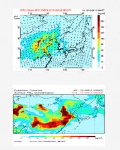
4 Introduction Korea is located in a region of rapid change with strong air quality gradients both in time and space. Started surface observation and forecasting air quality Asian NO 2 emissions from based on activity data (Ohara et al., 2007)

")
 will be launched in")
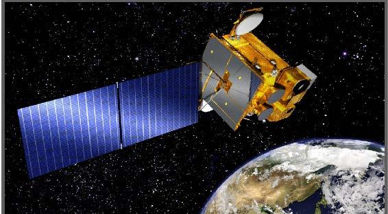
5 Introduction There are temporal and spatial limitations of the data to investigate climate change and air pollution (surface monitoring, LEO, ) Geostationary Environmental Monitoring Spectrometer(GEMS) will be launched in dense in urban area GEMS 5

6 Goal of KORUS-AQ campaign KORUS-AQ (Korean and U.S.) to implement an integrated observing system for improving understanding of Air Quality Airborne sampling - connecting ground-based and satellite observations - Short term Ground monitoring - The primary method for monitoring exposure. - limited coverage. KORUS-AQ Goals Improve capability for satellite remote sensing of air quality Better understanding of the factors controlling air quality Test and improve model simulation of air quality Satellites - broad coverage, continuity - it needs reliable information on n ear-surface exposure. Modeling - Air quality forecasting and warning service - it needs reliable information such as emission inventory [Courtesy of James Crawford and Joon-young Ahn] 6


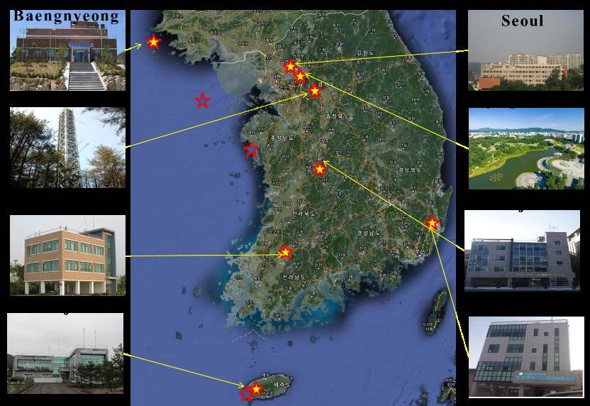
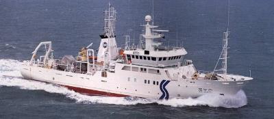


7 Observation platform NASA DC-8 LaRC King Air Hanseo King Air Geostationary Ocean Color Imager (GOCI) GOCI, OMI, MODIS, CALIPSO, IASI, etc Korean and US Air Quality Model Forecasts Surface Remote sensing: (Lidar, Aeronet, Pandora) RV Onnuri RV Kissng 7


 38 AERONET and SONET sites within")

8 Observation platform Surface remote sensing observation AERONET : Aerosol optical properties (AOD, SSA, FMF, AE, refractive index, etc.) Pandora : Total column trace gases (O3 and NO2) 38 AERONET and SONET sites within GOCI domain AQ_2016.html Korea AERONET & Pandora sites [Courtesy, Jhoon Kim] 8
 4 bands in IR (4 km) Aerosol products (Yonsei) AOD (4km) Mijin Kim et al.")
 8 bands in VIS-NIR (0.5 km) 4 bands in VIS-NIR (0.5/1.0 km) 12 bands in IR (2 km) Aerosol products (Yonsei) AOD, FMF, AE (6 km) Myungje Choi et al.")
9 Geostationary satellites aerosol observation MI/COMS (NMSC/KMA, Korea) 15-min interval for East Asia 3-hour interval for Full Disk (day and night) 1 bands in VIS (1 km) 4 bands in IR (4 km) Aerosol products (Yonsei) AOD (4km) Mijin Kim et al. (2014, 2016) GOCI/COMS (KOSC/KIOST, Korea) 1-hour interval for East Asia (total 8 times in daytime) AHI/Himawari-8 (JMA, Japan) 10-min interval for Full Disk (day and night) 8 bands in VIS-NIR (0.5 km) 4 bands in VIS-NIR (0.5/1.0 km) 12 bands in IR (2 km) Aerosol products (Yonsei) AOD, FMF, AE (6 km) Myungje Choi et al. (2016) Aerosol products (Yonsei) AOD, FMF, AE (6 km) Hyunkwang Lim et al. (2016) 9 [Courtesy, Jhoon Kim]
10 SURFACE REMOTE SENSING IN KORUS-AQ 10
 AOD (550 nm) AE (440-870 nm) AERONET AOD at Seoul")
.")

11 Observation result of Remote sensing Time series of AOD and AE during KORUS-AQ AOD (550 nm) AOD (550 nm) AE ( nm) AERONET AOD at Seoul (megacity region) and Gosan (coastal region) have lower values compare to other recent years (2011 to 2015). AERONET AOD in the latter part of the campaign shows higher values than in the former part and fine particles are usually observed over the Korea peninsula during KORUS-AQ campaign. 11 [Courtesy, Jhoon Kim]

 SSA (440nm) 12")
12 Observation result of Remote sensing Time series of AE and SSA during KORUS-AQ AE ( nm) SSA (440nm) 12 [Courtesy, Jhoon Kim]

 MI 4K 0400UTC GOCI 6K 0430UTC")

 MODIS DB")
 More")


13 Observation result of Remote sensing MODIS DT (0.2 ) MODIS DB (0.2 ) VIIRS EDR (0.2 ) MI 4K 0400UTC GOCI 6K 0430UTC AHI 6K 0400UTC MI 4K All meas. GOCI 6K All meas. AHI 6K All meas. High AOD over Western part of Korea MODIS DT (10K) MODIS DB (10K) MI 4K 0400UTC GOCI 6K 0430UTC AHI 6K 0400UTC MI 4K All meas. GOCI 6K All meas. AHI 6K All meas. VIIRS EDR (6K) More frequent GEO measurement times higher in No. of collocated data 13 [Courtesy, Jhoon Kim] Similar accuracy with LEO
 [Courtesy, Jhoon")
![Kim] Pandora Ozone and NO2 measurements have low and](/docs-images/86/94423887/images/14-3.jpg "high variability, respectively Olympic Park at urban")
14 Observation result of Remote sensing Pandora column amounts (Olympic Park time series) [Courtesy, Jhoon Kim] Pandora Ozone and NO2 measurements have low and high variability, respectively Olympic Park at urban area 14
![Observation result of Remote sensing Validation of Pandora O 3, NO 2 using OMI [Courtesy, Jhoon Kim] Seoul R = 0.97 Busan R = 0.98 GIST R = 0.](/docs-images/86/94423887/images/15-5.jpg "98 Temporal collocation: Averaging Pandora NO2 within ±30 minute from OMI overpass time Spatial collocation: Selecting OMI pixels within 30 km from each Pandora site For O 3, which has smaller")
15 Observation result of Remote sensing Validation of Pandora O 3, NO 2 using OMI [Courtesy, Jhoon Kim] Seoul R = 0.97 Busan R = 0.98 GIST R = 0.98 Temporal collocation: Averaging Pandora NO2 within ±30 minute from OMI overpass time Spatial collocation: Selecting OMI pixels within 30 km from each Pandora site For O 3, which has smaller spatial and temporal variability than NO 2, it was found that Pandora total VCD has high correlation with OMI (R>0.9). Pandora NO 2 has lower correlation with OMI data than O 3 because OMI has coarse spatial resolution and restricted observation time to measure NO 2 which has large 15 spatial and temporal variability.
16 Evaluation of GEMS Algorithm with KORUS-AQ 16
17 To help protect your privacy, PowerPoint has blocked automatic download of this picture. Method Airborne profile data collection and analysis - Airborne and CMAQ profiles during KORUS-AQ Airborne data is more detail! HCHO NO 2 SO 2 - Retrieval Column data using interpolation and integration 17

18 Evaluation result NO2 Algorithm Evaluation 1. Comparison with OMI satellite OMI Level 2 NO Lat: -5 ~ 45, Lon: 75 ~145 GEMS vs OMI 2. Airborne, , 12:00~15:00 LST DC-8 Spiral and track 18
, 12:00~15:00 LST SCD 2005, Lat: -5 ~ 45, Lon: 75 ~145 GEMS SCD vs OMI SCD GEMS VCD vs OMI VCD VCD - Slant Column Density(SCD) is similar with OMI, Vertical Column Density(VCD) has lower")
19 Evaluation result HCHO Algorithm Evaluation 1. Comparison with OMI satellite OMI Level 2 HCHO SCD VCD 2. Airborne, (KORUS-AQ), 12:00~15:00 LST SCD 2005, Lat: -5 ~ 45, Lon: 75 ~145 GEMS SCD vs OMI SCD GEMS VCD vs OMI VCD VCD - Slant Column Density(SCD) is similar with OMI, Vertical Column Density(VCD) has lower level of significance than SCD be required retrieve Air Mass Factor precisely 19
20 DEVELOPMENT OF GEO-TASO ALGORITHM 20

21 Introduction of Geo-TASO Geo-TASO (Geostationary Trace gas and Aerosol Sensor Optimization) - Payload for aircraft to test algorithms performance of GEMS Retrieval of trace gas from Earth radiation intensity with UV-Vis hyper-spectrometer < Nowlan et al. > System Parameter Dispersion Value UV: 0.14 nm/pix; Vis: 0.28 nm/pix Spectral Passband UV: nm; Vis: nm Spectral Sampling Spatial images/sampling (at 32 kft AGL) Cross-track swath (at 32 kft AGL) samples/fwhm 40 by 80m IFOVs; 8 by 50m sampling 8 km < Leitch et al. > 21
22 Introduction of Geo-TASO To improve GEMS Level2 Algorithms, GeoTASO and Sunphotometer are utilized as a test-bed * GeoTASO : the Airborne payload in KORUS-AQ campaign, * Sunphotometer : an aerosol ground observation Special feature of GeoTASO - Higher spatial resolution - Observations are not guaranteed to see temporal change at specific points. Development of airborne algorithm is needed. 22
23 Geo-TASO Algorithm Wavelength Cal/Val Algorithm Develop wavelength cal/val algorithm for Geo-TASO with addition of Ozone and ring effect Sensitivity to UV area and cloud is reduced compared with previous algorithm Before After Reference Measurement Reference Measurement Correlaiton: RMSE: Correlation: RMSE: [Courtesy, Myoung-hwan Ahn]
 REFERENCE SPECTRA")
 Residual is fitted as 1e-03 order 24 24 [Courtesy,")
24 Geo-TASO Algorithm Ozone Algorithm GTASO reference (Clear sky) LEAST SQUA RES FITTING DOAS Fitting result ( nm) REFERENCE SPECTRA (SAO) + TEMPERATURE DEPENDENCE + Used Xsec (O 3 243K, O 3 293K ring, SO 2, NO 2 ) Residual is fitted as 1e-03 order [Courtesy, Jae-hwan Kim]

). Fitting window: 432 ~ 450 nm Cross section: NO 2 _294K (Vandaele et al.")
25 Geo-TASO Algorithm NO2 Algorithm NO 2 SCD (May, 17,2016) Spectrum (GEO-TASO) Reference spectrum FWHM: 0.91 nm QDOAS spectral fitting software (developed at the Royal Belgian institute for Space Aeronomy (BIRA-IASB)). Fitting window: 432 ~ 450 nm Cross section: NO 2 _294K (Vandaele et al., 1998), ozone_273k (Bogumil et al., 2000), ring (Chance and Spurr 1997) 25 [Courtesy, Hyunkee Hong]
 NO 2 AMF (May, 17, 2016) Courtesy of Jhoon Kim and Myeong Jae Choi MODIS surface reflectance (May, 17, 2016) B200 SZA, VZA, RAA, Height")
26 Geo-TASO Algorithm NO 2 AMF calculation GOCI AOD (May, 17, 2016) The aerosol vertical distribution is based on a Gaussian distribution function (GDF) and Aerosol peak height is assumed as 1 km. [Courtesy, Hyunkee Hong] MODIS SSA (May, 17, 2016) NO 2 AMF (May, 17, 2016) Courtesy of Jhoon Kim and Myeong Jae Choi MODIS surface reflectance (May, 17, 2016) B200 SZA, VZA, RAA, Height 26

27 Geo-TASO Algorithm Tropospheric NO 2 VCD retrieval NO 2 SCD <May, 17, 2016> Tropospheric NO 2 VCD & in-situ NO 2 VMR at the same time AMF Max: molecules cm -2 Sungnam(14:36) 27 [Courtesy, Hyunkee Hong]
28 Summary During KORUS-AQ, it is used for observation such as ground-based remote sensing, airborne, satellite, and modeling. The result of surface remote sensing is matched well with last 5 years. In GEMS evaluation, the results of Ozone compared with DC-8 or OMI were significant, but we found that formaldehyde requires AMF improvement. To understand GEO-TASO observation result, we develop GEO-TASO algorithm and it is undergoing improvement. We will evaluate GEMS algorithm more with KORUS-AQ results so that GEMS will offer products with significant quality. 28
29 THANK YOU FOR YOUR ATTENTION! 29
 0 n j= 1 S j ( λ) c j due to Rayleigh & Mie scattering Calculated from Polynomial models Credit: H. L.")
30 Retrieval Algorithm Differential Optical Absorption Spectroscopy (DOAS) The beer-lambert law j I( λ) = I ( λ)exp( S ( λ) c o n j= 1 j ) Optical thickness (density) I( λ) τ ln( ) = I ( λ) 0 n j= 1 S j ( λ) c j due to Rayleigh & Mie scattering Calculated from Polynomial models Credit: H. L. Lee Slant columns (SCD) calculated from a fitting method / 43
 = VCD From Satellite The AMF i are also often called Scat tering Weights The AMF expresses the sensitivity of the measurement, and depends on a variety of parameters such as: wavelength geometry")
31 Retrieval Algorithm VCD SCD The AMF is defined as the ratio of the measured slant column to th e vertical column in the atmosph ere: AMF G = 1 cos( θ ) + 1 cos( ϕ) AMF SCD( λ, Θ,...) = VCD From Satellite The AMF i are also often called Scat tering Weights The AMF expresses the sensitivity of the measurement, and depends on a variety of parameters such as: wavelength geometry vertical distribution of the species clouds aerosol loading surface albedo Calculate AMF with RTM Credit: / 43
Status of GEMS. GEMS Science Team
 Image Credit, NASA LaRC Status of GEMS GEMS Science Team NIER, Yonsei Univ, Ewha WU, GIST, GWNU, KARI, KPNU, PKNU, PNU, SNU, UNIST; BIRA, CAS, Chiba U, ESA, Harvard Smithonian CfA, Houston U., JAXA, NASA,
TEMPO & GOES-R synergy update and! GEO-TASO aerosol retrieval!
 TEMPO & GOES-R synergy update and! GEO-TASO aerosol retrieval! Jun Wang! Xiaoguang Xu, Shouguo Ding, Weizhen Hou! University of Nebraska-Lincoln!! Robert Spurr! RT solutions!! Xiong Liu, Kelly Chance!
Global and Regional Retrieval of Aerosol from MODIS
 Global and Regional Retrieval of Aerosol from MODIS Why study aerosols? CLIMATE VISIBILITY Presented to UMBC/NESDIS June 4, 24 Robert Levy, Lorraine Remer, Yoram Kaufman, Allen Chu, Russ Dickerson modis-atmos.gsfc.nasa.gov
GeoTASO Project Summary and Relevance. Jim Leitch Ball Aerospace
 GeoTASO Project Summary and Relevance Jim Leitch Ball Aerospace jleitch@ball.com 303-939-5280 4/23/2013 Sensor Concept Overview Airborne nadir-viewing wide-swath imaging spectrometer Two channel spectrometer
UV Remote Sensing of Volcanic Ash
 UV Remote Sensing of Volcanic Ash Kai Yang University of Maryland College Park WMO Inter-comparison of Satellite-based Volcanic Ash Retrieval Algorithms Workshop June 26 July 2, 2015, Madison, Wisconsin
SWIR/VIS Reflectance Ratio Over Korea for Aerosol Retrieval
 Korean Journal of Remote Sensing, Vol.23, No.1, 2007, pp.1~5 SWIR/VIS Reflectance Ratio Over Korea for Aerosol Retrieval Kwon Ho Lee*, Zhangqing Li*, Young Joon Kim** *Earth System Science Interdisciplinary
Interactive comment on Quantification and mitigation of the impact of scene inhomogeneity on Sentinel-4 UVN UV-VIS retrievals by S. Noël et al.
 Atmos. Meas. Tech. Discuss., www.atmos-meas-tech-discuss.net/5/c741/2012/ Author(s) 2012. This work is distributed under the Creative Commons Attribute 3.0 License. Atmospheric Measurement Techniques Discussions
Interactive comment on Quantification and mitigation of the impact of scene inhomogeneity on Sentinel-4 UVN UV-VIS retrievals by S. Noël et al.
 Atmos. Meas. Tech. Discuss., 5, C741 C750, 2012 www.atmos-meas-tech-discuss.net/5/c741/2012/ Author(s) 2012. This work is distributed under the Creative Commons Attribute 3.0 License. Atmospheric Measurement
JAXA Himawari Monitor Aerosol Products. JAXA Earth Observation Research Center (EORC) September 2018
 September 2018") JAXA Himawari Monitor Aerosol Products JAXA Earth Observation Research Center (EORC) September 2018 1 2 JAXA Himawari Monitor JAXA has been developing Himawari-8 products using the retrieval algorithms
JAXA Himawari Monitor Aerosol Products JAXA Earth Observation Research Center (EORC) September 2018 1 2 JAXA Himawari Monitor JAXA has been developing Himawari-8 products using the retrieval algorithms
Overview and Status of GEMS
 Overview and Status of GEMS Jhoon Kim, GEMS Team Yonsei University Changwoo Ahn Jay Al-Saadi P.K. Bhartia Kevin Bowman Greg Carmichael Kelly Chance Yunsoo Choi Ron Cohen Russ Dickerson David Edwards Annmarie
LIDORT family of Radiative Transfer Models Applications to the TEMPO Project
 LIDORT family of Radiative Transfer Models Applications to the TEMPO Project Robert Spurr, RT Solutions Inc. 9 Channing Street, Cambridge, Mass. First TEMPO Science Team Meeting Harvard-Smithsonian CfA,
NASA e-deep Blue aerosol update: MODIS Collection 6 and VIIRS
 NASA e-deep Blue aerosol update: MODIS Collection 6 and VIIRS Andrew M. Sayer, N. Christina Hsu (PI), Corey Bettenhausen, Nick Carletta, Jaehwa Lee, Colin Seftor, Jeremy Warner Past team members: Ritesh
Preliminary validation of Himawari-8/AHI navigation and calibration
 Preliminary validation of Himawari-8/AHI navigation and calibration Arata Okuyama 1, Akiyoshi Andou 1, Kenji Date 1, Nobutaka Mori 1, Hidehiko Murata 1, Tasuku Tabata 1, Masaya Takahashi 1, Ryoko Yoshino
JAXA Himawari Monitor Aerosol Products. JAXA Earth Observation Research Center (EORC) August 2018
 August 2018") JAXA Himawari Monitor Aerosol Products JAXA Earth Observation Research Center (EORC) August 2018 1 JAXA Himawari Monitor JAXA has been developing Himawari 8 products using the retrieval algorithms based
JAXA Himawari Monitor Aerosol Products JAXA Earth Observation Research Center (EORC) August 2018 1 JAXA Himawari Monitor JAXA has been developing Himawari 8 products using the retrieval algorithms based
Prototyping GOES-R Albedo Algorithm Based on MODIS Data Tao He a, Shunlin Liang a, Dongdong Wang a
 Prototyping GOES-R Albedo Algorithm Based on MODIS Data Tao He a, Shunlin Liang a, Dongdong Wang a a. Department of Geography, University of Maryland, College Park, USA Hongyi Wu b b. University of Electronic
Comparison of Full-resolution S-NPP CrIS Radiance with Radiative Transfer Model
 Comparison of Full-resolution S-NPP CrIS Radiance with Radiative Transfer Model Xu Liu NASA Langley Research Center W. Wu, S. Kizer, H. Li, D. K. Zhou, and A. M. Larar Acknowledgements Yong Han NOAA STAR
Atmospheric correction of hyperspectral ocean color sensors: application to HICO
 Atmospheric correction of hyperspectral ocean color sensors: application to HICO Amir Ibrahim NASA GSFC / USRA Bryan Franz, Zia Ahmad, Kirk knobelspiesse (NASA GSFC), and Bo-Cai Gao (NRL) Remote sensing
Algorithm development for aerosol retrieval and its validation based on combined use of polarization and radiance measurements
 Algorithm development for aerosol retrieval and its validation based on combined use of polarization and radiance measurements I. Sano, and CI team CIs : S. Mukai, M. Nakata, B. Holben, O. Dubovik, A.
GEOG 4110/5100 Advanced Remote Sensing Lecture 2
 GEOG 4110/5100 Advanced Remote Sensing Lecture 2 Data Quality Radiometric Distortion Radiometric Error Correction Relevant reading: Richards, sections 2.1 2.8; 2.10.1 2.10.3 Data Quality/Resolution Spatial
GRASP Algorithm: Retrieval of the detailed properties of atmospheric aerosol from PARASOL and other sensors
 GRASP Algorithm: Retrieval of the detailed properties of atmospheric aerosol from PARASOL and other sensors Oleg Dubovik (University of Lille-1, CNRS, France) GRASP team: P. Litvinov 1,T. Lapyonok 1, F.
Menghua Wang NOAA/NESDIS/STAR Camp Springs, MD 20746, USA
 Ocean EDR Product Calibration and Validation Plan Progress Report: VIIRS Ocean Color Algorithm Evaluations and Data Processing and Analyses Define a VIIRS Proxy Data Stream Define the required in situ
OMAERO README File. Overview. B. Veihelmann, J.P. Veefkind, KNMI. Last update: November 23, 2007
 OMAERO README File B. Veihelmann, J.P. Veefkind, KNMI Last update: November 23, 2007 Overview The OMAERO Level 2 data product contains aerosol characteristics such as aerosol optical thickness (AOT), aerosol
Improved MODIS Aerosol Retrieval using Modified VIS/MIR Surface Albedo Ratio Over Urban Scenes
 Improved MODIS Aerosol Retrieval using Modified VIS/MIR Surface Albedo Ratio Over Urban Scenes Min Min Oo, Matthias Jerg, Yonghua Wu Barry Gross, Fred Moshary, Sam Ahmed Optical Remote Sensing Lab City
Towards a Portal to Atmospheric and Marine Information Resources (PAMIR)
") Towards a Portal to Atmospheric and Marine Information Resources (PAMIR) Anne De Rudder, Jean-Christopher Lambert Belgian Institute for Space Aeronomy (IASB-BIRA) Serge Scory, Myriam Nemry Royal Belgian
Towards a Portal to Atmospheric and Marine Information Resources (PAMIR) Anne De Rudder, Jean-Christopher Lambert Belgian Institute for Space Aeronomy (IASB-BIRA) Serge Scory, Myriam Nemry Royal Belgian
Retrieval of Aerosol and Cloud Properties using the ATSR Dual and Single View algorithms
 Retrieval of Aerosol and Cloud Properties using the ATSR Dual and Single View algorithms Gerrit de Leeuw 1,2, Larisa Sogacheva 1, Pekka Kolmonen 1, Giulia Saponaro 1, Timo H. Virtanen 1, Edith Rodriguez
Digital Earth Routine on Tegra K1
 Digital Earth Routine on Tegra K1 Aerosol Optical Depth Retrieval Performance Comparison and Energy Efficiency Energy matters! Ecological A topic that affects us all Economical Reasons Practical Curiosity
Direct radiative forcing of aerosol
 Direct radiative forcing of aerosol 1) Model simulation: A. Rinke, K. Dethloff, M. Fortmann 2) Thermal IR forcing - FTIR: J. Notholt, C. Rathke, (C. Ritter) 3) Challenges for remote sensing retrieval:
An Innovative Satellite SO 2 and HCHO Retrieval Algorithm based on Principal Component Analysis: Contribution to the Sentinel-5P Mission
 An Innovative Satellite SO 2 and HCHO Retrieval Algorithm based on Principal Component Analysis: Contribution to the Sentinel-5P Mission Nickolay Krotkov 1, Can Li 1, 2, Joanna Joiner 1, Vitali Fioletov
Satellite Infrared Radiance Validation Studies using a Multi-Sensor/Model Data Fusion Approach
 Satellite Infrared Radiance Validation Studies using a Multi-Sensor/Model Data Fusion Approach Aqua A. Larar a, W. Smith b, D. Zhou a, X. Liu a, and S. Mango c a NASA Langley Research Center, Hampton,
The ACC meeting location is on the campus of Yonsei University in Room B110 of The Lounge, Building 130 (Underground). See attached map, p.6.
. See attached map, p.6.") Dear all, Please see below the final agenda of the CEOS-ACC-12 meeting. As communicated earlier (see also http://ceos.org/meetings/ac-vc-12) the meeting will take place in Seoul, Korea, October 13-14,
Dear all, Please see below the final agenda of the CEOS-ACC-12 meeting. As communicated earlier (see also http://ceos.org/meetings/ac-vc-12) the meeting will take place in Seoul, Korea, October 13-14,
Aerosol Remote Sensing from PARASOL and the A-Train
 Aerosol Remote Sensing from PARASOL and the A-Train J.-F. Léon, D. Tanré, J.-L. Deuzé, M. Herman, P. Goloub, P. Lallart Laboratoire d Optique Atmosphérique, France A. Lifermann Centre National d Etudes
Infrared Scene Simulation for Chemical Standoff Detection System Evaluation
 Infrared Scene Simulation for Chemical Standoff Detection System Evaluation Peter Mantica, Chris Lietzke, Jer Zimmermann ITT Industries, Advanced Engineering and Sciences Division Fort Wayne, Indiana Fran
GOME-2 surface LER product
 REFERENCE: ISSUE: DATE: PAGES: 2.2 2 May 2017 20 PRODUCT USER MANUAL GOME-2 surface LER product Product Identifier Product Name O3M-89.1 O3M-90 Surface LER from GOME-2 / MetOp-A Surface LER from GOME-2
Using LiDAR for Classification and
 Using LiDAR for Classification and Recognition of Particulate Matter in the Atmosphere M. Elbakary, K. Iftekharuddin, and K. AFRIFA ECE Dept., Old Dominion University, Norfolk, VA Outline Goals of the
Physical Modeling for Processing Geosynchronous Imaging Fourier Transform Spectrometer (GIFTS) Indian Ocean METOC Imager (IOMI) Hyperspectral Data
 Indian Ocean METOC Imager (IOMI) Hyperspectral Data") University of Wisconsin - Madison (UW) University of Hawaii (UH) Texas A& M (TAMU) University of Colorado at Boulder (CU) University of Alabama in Huntsville (UAH) MURI Physical Modeling for Processing
University of Wisconsin - Madison (UW) University of Hawaii (UH) Texas A& M (TAMU) University of Colorado at Boulder (CU) University of Alabama in Huntsville (UAH) MURI Physical Modeling for Processing
Aerosol retrieval algorithm for the characterization of local aerosol using MODIS L1B data
 IOP Conference Series: Earth and Environmental Science OPEN ACCESS Aerosol retrieval algorithm for the characterization of local aerosol using MODIS L1B data To cite this article: A M Wahab and M L R Sarker
Monitoring of IR Clear-sky Radiances over Oceans for SST (MICROS) for Himawari-8 AHI
 for Himawari-8 AHI") NOAA Cooperative Research Program (CoRP), 11 th Annual Science Symposium 16-17 September 2015, UMD, College Park, USA Monitoring of IR Clear-sky Radiances over Oceans for SST (MICROS) for Himawari-8 AHI
NOAA Cooperative Research Program (CoRP), 11 th Annual Science Symposium 16-17 September 2015, UMD, College Park, USA Monitoring of IR Clear-sky Radiances over Oceans for SST (MICROS) for Himawari-8 AHI
Lecture 13.1: Airborne Lidar Systems
 Lecture 13.1: Airborne Lidar Systems 1. Introduction v The main advantages of airborne lidar systems are that they expand the geographical range of studies beyond those possible by surface-based fixed
The 4A/OP model: from NIR to TIR, new developments for time computing gain and validation results within the frame of international space missions
 ITSC-21, Darmstadt, Germany, November 29th-December 5th, 2017 session 2a Radiative Transfer The 4A/OP model: from NIR to TIR, new developments for time computing gain and validation results within the
MTG-FCI: ATBD for Outgoing Longwave Radiation Product
 MTG-FCI: ATBD for Outgoing Longwave Radiation Product Doc.No. Issue : : EUM/MTG/DOC/10/0527 v2 EUMETSAT Eumetsat-Allee 1, D-64295 Darmstadt, Germany Tel: +49 6151 807-7 Fax: +49 6151 807 555 Date : 14
The NIR- and SWIR-based On-orbit Vicarious Calibrations for VIIRS
 The NIR- and SWIR-based On-orbit Vicarious Calibrations for VIIRS Menghua Wang NOAA/NESDIS/STAR E/RA3, Room 3228, 5830 University Research Ct. College Park, MD 20746, USA Menghua.Wang@noaa.gov Workshop
Aerosol Optical Depth Retrieval from Satellite Data in China. Professor Dr. Yong Xue
 Aerosol Optical Depth Retrieval from Satellite Data in China Professor Dr. Yong Xue Research Report Outline Multi-scale quantitative retrieval of Aerosol optical depth (AOD) over land Spatial resolution:
WinDOAS 2.1 Software User Manual
 WinDOAS 2.1 Software User Manual Caroline FAYT Michel VAN ROOZENDAEL BIRA-IASB WinDOAS 2.1 Software User Manual WinDOAS is distributed without any restrictions. In case of publications making use of WinDOAS,
Data Mining Support for Aerosol Retrieval and Analysis:
 Data Mining Support for Aerosol Retrieval and Analysis: Our Approach and Preliminary Results Zoran Obradovic 1 joint work with Amy Braverman 2, Bo Han 1, Zhanqing Li 3, Yong Li 1, Kang Peng 1, Yilian Qin
Radiance Based VIIRS LST Product Validation
 2017 CICS Science Conference Radiance Based VIIRS LST Product Validation Heshun Wang 1,2, Yunyue Yu 2, Yuling Liu 1,2, Peng Yu 1,2 1. Cooperative Institute for Climate and Satellites, University of Maryland
ATMOSPHERIC CORRECTION ITERATIVE METHOD FOR HIGH RESOLUTION AEROSPACE IMAGING SPECTROMETERS
 ATMOSPHERIC CORRECTION ITERATIVE METHOD FOR HIGH RESOLUTION AEROSPACE IMAGING SPECTROMETERS Alessandro Barducci, Donatella Guzzi, Paolo Marcoionni, Ivan Pippi * CNR IFAC Via Madonna del Piano 10, 50019
Land surface temperature products validation for
 FRM4STS International Workshop, National Physical Laboratory, Teddington, UK Land surface temperature products validation for GOES-R and JPSS missions: status and challenge Yuhan Rao 1,2, Yunyue (Bob)
Seawater reflectance in the near-ir
 Seawater reflectance in the near-ir Maéva DORON David DOXARAN Simon BELANGER Marcel BABIN Laboratoire d'océanographie de Villefranche Seawater Reflectance in the Near-IR Doron, Doxaran, Bélanger & Babin
Estimating land surface albedo from polar orbiting and geostationary satellites
 Estimating land surface albedo from polar orbiting and geostationary satellites Dongdong Wang Shunlin Liang Tao He Yuan Zhou Department of Geographical Sciences University of Maryland, College Park Nov
(Towards) A metadata model for atmospheric data resources
 A metadata model for atmospheric data resources") (Towards) A metadata model for atmospheric data resources Anne De Rudder and Jean-Christopher Lambert Belgian Institute for Space Aeronomy (IASB-BIRA), Brussels The context EU FP7 Ground-based atmospheric
(Towards) A metadata model for atmospheric data resources Anne De Rudder and Jean-Christopher Lambert Belgian Institute for Space Aeronomy (IASB-BIRA), Brussels The context EU FP7 Ground-based atmospheric
LIDAR an Introduction and Overview
 LIDAR an Introduction and Overview Rooster Rock State Park & Crown Point. Oregon DOGAMI Lidar Project Presented by Keith Marcoe GEOG581, Fall 2007. Portland State University. Light Detection And Ranging
GOME NO 2 data product HDF data file user manual
 GOME NO 2 data product HDF data file user manual Folkert Boersma and Henk Eskes 23 April 2002 Contents Content of the no2trackyyyymmdd.hdf files 3 The use of the averaging kernel 6 IDL sample code to read
Improvements to Ozone Mapping Profiler Suite (OMPS) Sensor Data Record (SDR)
 Sensor Data Record (SDR)") Improvements to Ozone Mapping Profiler Suite (OMPS) Sensor Data Record (SDR) *C. Pan 1, F. Weng 2, T. Beck 2 and S. Ding 3 * 1 ESSIC, University of Maryland, College Park, MD 20740; 2 NOAA NESDIS/STAR,
Improvements to Ozone Mapping Profiler Suite (OMPS) Sensor Data Record (SDR) *C. Pan 1, F. Weng 2, T. Beck 2 and S. Ding 3 * 1 ESSIC, University of Maryland, College Park, MD 20740; 2 NOAA NESDIS/STAR,
Laser Beacon Tracking for High-Accuracy Attitude Determination
 Laser Beacon Tracking for High-Accuracy Attitude Determination Tam Nguyen Massachusetts Institute of Technology 29 th AIAA/USU Conference on Small Satellites SSC15-VIII-2 08/12/2015 Outline Motivation
Spectral imagers for nanosatellites
 VTT TECHNICAL RESEARCH CENTRE OF FINLAND LTD Spectral imagers for nanosatellites Finnish Satellite Workshop 2018 Antti Näsilä VTT Microspectrometers Fabry-Perot (FPI) technology for miniaturizing optical
Kohei Arai 1 1Graduate School of Science and Engineering Saga University Saga City, Japan. Kenta Azuma 2 2 Cannon Electronics Inc.
 Method for Surface Reflectance Estimation with MODIS by Means of Bi-Section between MODIS and Estimated Radiance as well as Atmospheric Correction with Skyradiometer Kohei Arai 1 1Graduate School of Science
Defining Remote Sensing
 Defining Remote Sensing Remote Sensing is a technology for sampling electromagnetic radiation to acquire and interpret non-immediate geospatial data from which to extract information about features, objects,
Class 11 Introduction to Surface BRDF and Atmospheric Scattering. Class 12/13 - Measurements of Surface BRDF and Atmospheric Scattering
 University of Maryland Baltimore County - UMBC Phys650 - Special Topics in Experimental Atmospheric Physics (Spring 2009) J. V. Martins and M. H. Tabacniks http://userpages.umbc.edu/~martins/phys650/ Class
Revision History. Applicable Documents
 Revision History Version Date Revision History Remarks 1.0 2011.11-1.1 2013.1 Update of the processing algorithm of CAI Level 3 NDVI, which yields the NDVI product Ver. 01.00. The major updates of this
Lecture 03. Fundamentals of Lidar Remote Sensing (1)
") Lecture 03. Fundamentals of Lidar Remote Sensing (1) q Introduction q History from searchlight to modern lidar q Various modern lidars q Determination of Altitude and Range q Summary and Questions 1 Introduction:
Lecture 03. Fundamentals of Lidar Remote Sensing (1) q Introduction q History from searchlight to modern lidar q Various modern lidars q Determination of Altitude and Range q Summary and Questions 1 Introduction:
Aerosol retrieval using polarimetric observations: THEORY and PRACTICE. What users should expect from polarization?
 Aerosol retrieval using polarimetric observations: THEORY and PRACTICE What users should expect from polarization? GRASP O. Dubovik1, P. Litvinov1, D. Tanré1, T. Lapyonok1, A. Fedorenko1, A. Lopatin1,
High resolution aerosol optical thickness retrieval over the Pearl River Delta region with improved aerosol modelling
 Science in China Series D: Earth Sciences 2009 SCIENCE IN CHINA PRESS Springer www.scichina.com earth.scichina.com www.springerlink.com High resolution aerosol optical thickness retrieval over the Pearl
Motivation. Aerosol Retrieval Over Urban Areas with High Resolution Hyperspectral Sensors
 Motivation Aerosol etrieval Over Urban Areas with High esolution Hyperspectral Sensors Barry Gross (CCNY) Oluwatosin Ogunwuyi (Ugrad CCNY) Brian Cairns (NASA-GISS) Istvan Laszlo (NOAA-NESDIS) Aerosols
Chapter 24. Geometric optics. Assignment No. 11, due April 27th before class: Problems 24.4, 24.11, 24.13, 24.15, 24.24
 Chapter 24 Geometric optics Assignment No. 11, due April 27th before class: Problems 24.4, 24.11, 24.13, 24.15, 24.24 A Brief History of Light 1000 AD It was proposed that light consisted of tiny particles
Modeling of the ageing effects on Meteosat First Generation Visible Band
 on on Meteosat First Generation Visible Band Ilse Decoster, N. Clerbaux, J. Cornelis, P.-J. Baeck, E. Baudrez, S. Dewitte, A. Ipe, S. Nevens, K. J. Priestley, A. Velazquez Royal Meteorological Institute
OCEANSAT-2 OCEAN COLOUR MONITOR (OCM-2)
") OCEANSAT-2 OCEAN COLOUR MONITOR (OCM-2) Update of post launch vicarious, lunar calibrations & current status Presented by Prakash Chauhan Space Applications Centre Indian Space Research Organistaion Ahmedabad-
OCEANSAT-2 OCEAN COLOUR MONITOR (OCM-2) Update of post launch vicarious, lunar calibrations & current status Presented by Prakash Chauhan Space Applications Centre Indian Space Research Organistaion Ahmedabad-
VIIRS Radiance Cluster Analysis under CrIS Field of Views
 VIIRS Radiance Cluster Analysis under CrIS Field of Views Likun Wang, Yong Chen, Denis Tremblay, Yong Han ESSIC/Univ. of Maryland, College Park, MD; wlikun@umd.edu Acknowledgment CrIS SDR Team 2016 CICS
1.Rayleigh and Mie scattering. 2.Phase functions. 4.Single and multiple scattering
 5 November 2014 Outline 1.Rayleigh and Mie scattering 2.Phase functions 3.Extinction 4.Single and multiple scattering Luca Lelli luca@iup.physik.uni-bremen.de Room U2080 Phone 0421.218.62097 Scattering
Exploring Techniques for Improving Retrievals of Bio-optical Properties of Coastal Waters
 DISTRIBUTION STATEMENT A. Approved for public release; distribution is unlimited. Exploring Techniques for Improving Retrievals of Bio-optical Properties of Coastal Waters Samir Ahmed Department of Electrical
RECENT ADVANCES IN THE SCIENCE OF RTTOV. Marco Matricardi ECMWF Reading, UK
 RECENT ADVANCES IN THE SCIENCE OF RTTOV Marco Matricardi ECMWF Reading, UK RTTOV is the NWP SAF fast radiative transfer model and is developed jointly by ECMWF, the Met Office and Météo France. In this
User Interface: Simple Model of Atmospheric Radiative Transfer of Sunshine
 User Interface: Simple Model of Atmospheric Radiative Transfer of Sunshine April 2003 WINDOWS Version Introduction This document provides instructions for installing and running the User Interface for
[Sakthivel *, 5(11): November 2018] ISSN DOI /zenodo Impact Factor
![[Sakthivel *, 5(11): November 2018] ISSN DOI /zenodo Impact Factor](/thumbs/91/105145249.jpg "[Sakthivel *, 5(11): November 2018] ISSN DOI /zenodo Impact Factor") GLOBAL JOURNAL OF ENGINEERING SCIENCE AND RESEARCHES ATMOSPHERIC CORRECTION OF VISIBLE CHANNEL OF SATELLITE IMAGE FROM INSAT-3D IMAGER USING SECOND SIMULATION OF THE SATELLITE SIGNAL IN THE SOLAR SPECTRUM
GLOBAL JOURNAL OF ENGINEERING SCIENCE AND RESEARCHES ATMOSPHERIC CORRECTION OF VISIBLE CHANNEL OF SATELLITE IMAGE FROM INSAT-3D IMAGER USING SECOND SIMULATION OF THE SATELLITE SIGNAL IN THE SOLAR SPECTRUM
Bayesian aerosol retrieval algorithm for MODIS AOD retrieval over land
 https://doi.org/10.5194/amt-11-1529-2018 Author(s) 2018. This work is distributed under the Creative Commons Attribution 4.0 License. Bayesian aerosol retrieval algorithm for MODIS AOD retrieval over land
Airborne LiDAR Data Acquisition for Forestry Applications. Mischa Hey WSI (Corvallis, OR)
") Airborne LiDAR Data Acquisition for Forestry Applications Mischa Hey WSI (Corvallis, OR) WSI Services Corvallis, OR Airborne Mapping: Light Detection and Ranging (LiDAR) Thermal Infrared Imagery 4-Band
Airborne LiDAR Data Acquisition for Forestry Applications Mischa Hey WSI (Corvallis, OR) WSI Services Corvallis, OR Airborne Mapping: Light Detection and Ranging (LiDAR) Thermal Infrared Imagery 4-Band
Shortwave infrared measurements of the TROPOMI instrument on the Sentinel 5 Precursor mission
 Shortwave infrared measurements of the TROPOMI instrument on the Sentinel 5 Precursor mission Jochen Landgraf 1, Joost aan de Brugh 1, Haili Hu 1,Tobias Borsdorff 1, Remco Scheepmaker 1, Andre Butz 2,
Polar Multi-Sensor Aerosol Product: ATBD
 Polar Multi-Sensor Aerosol Product: ATBD Doc.No. : EUM/TSS/SPE/14/739904 Issue : v3b e-signed Date : 30 November 2015 WBS : EUMETSAT Eumetsat-Allee 1, D-64295 Darmstadt, Germany Tel: +49 6151 807-7 Fax:
A Survey of Modelling and Rendering of the Earth s Atmosphere
 Spring Conference on Computer Graphics 00 A Survey of Modelling and Rendering of the Earth s Atmosphere Jaroslav Sloup Department of Computer Science and Engineering Czech Technical University in Prague
Atmospheric Chemistry and Physics
 Author(s) 27. This work is licensed under a Creative Commons License. Atmospheric Chemistry and Physics Comparison of box-air-mass-factors and radiances for Multiple-Axis Differential Optical Absorption
Hyperspectral Remote Sensing
 Hyperspectral Remote Sensing Multi-spectral: Several comparatively wide spectral bands Hyperspectral: Many (could be hundreds) very narrow spectral bands GEOG 4110/5100 30 AVIRIS: Airborne Visible/Infrared
Micro-Pulse Lidar Network (MPLNET): 10 Years of Trying to Imitate AERONET
: 10 Years of Trying to Imitate AERONET") Micro-Pulse Lidar Network (MPLNET): 10 Years of Trying to Imitate AERONET Principal Investigator: Judd Welton, NASA GSFC Code 613.1 Instrumentation & Network Management: Sebastian Stewart, SSAI GSFC Code
Micro-Pulse Lidar Network (MPLNET): 10 Years of Trying to Imitate AERONET Principal Investigator: Judd Welton, NASA GSFC Code 613.1 Instrumentation & Network Management: Sebastian Stewart, SSAI GSFC Code
TOA RADIANCE SIMULATOR FOR THE NEW HYPERSPECTRAL MISSIONS: STORE (SIMULATOR OF TOA RADIANCE)
") TOA RADIANCE SIMULATOR FOR THE NEW HYPERSPECTRAL MISSIONS: STORE (SIMULATOR OF TOA RADIANCE) Malvina Silvestri Istituto Nazionale di Geofisica e Vulcanologia In the frame of the Italian Space Agency (ASI)
TOA RADIANCE SIMULATOR FOR THE NEW HYPERSPECTRAL MISSIONS: STORE (SIMULATOR OF TOA RADIANCE) Malvina Silvestri Istituto Nazionale di Geofisica e Vulcanologia In the frame of the Italian Space Agency (ASI)
Motion tracking and cloud height assignment methods for Himawari-8 AMV
 Motion tracking and cloud height assignment methods for Himawari-8 AMV Kazuki Shimoji Japan Meteorological Agency / Meteorological Satellite Center 3-235, Nakakiyoto, Kiyose, Tokyo, Japan Abstract Japanese
Aeolus L2A optical properties products and assimilation in air quality models
 Aeolus L2A optical properties products and assimilation in air quality models Thomas Flament, Angela Benedetti, P. Martinet, E. Martins, L. El Amraoui, A. Dabas, P. Flamant Toulouse, 28 March 2017 Aladin,
OMI Algorithm Theoretical Basis Document. Volume II
 OMI Algorithm Theoretical Basis Document Volume II OMI Ozone Products Edited by Pawan K Bhartia NASA Goddard Space Flight Center Greenbelt, Maryland, USA ATBD-OMI-02, Version 2.0, August 2002 2 ATBD-OMI-02
Linking sun-induced fluorescence and photosynthesis in a forest ecosystem
 Linking sun-induced fluorescence and photosynthesis in a forest ecosystem COST ES1309 Tagliabue G, Panigada C, Dechant B, Celesti M, Cogliati S, Colombo R, Julitta T, Meroni M, Schickling A, Schuettemeyer
Interactive comment on Quantification and mitigation of the impact of scene inhomogeneity on Sentinel-4 UVN UV-VIS retrievals by S. Noël et al.
 Atmos. Meas. Tech. Discuss., 5, C751 C762, 2012 www.atmos-meas-tech-discuss.net/5/c751/2012/ Author(s) 2012. This work is distributed under the Creative Commons Attribute 3.0 License. Atmospheric Measurement
Evaluation of Satellite Ocean Color Data Using SIMBADA Radiometers
 Evaluation of Satellite Ocean Color Data Using SIMBADA Radiometers Robert Frouin Scripps Institution of Oceanography, la Jolla, California OCR-VC Workshop, 21 October 2010, Ispra, Italy The SIMBADA Project
Improved Global Ocean Color using POLYMER Algorithm
 Improved Global Ocean Color using POLYMER Algorithm François Steinmetz 1 Didier Ramon 1 Pierre-Yves Deschamps 1 Jacques Stum 2 1 Hygeos 2 CLS June 29, 2010 ESA Living Planet Symposium, Bergen, Norway c
Retrieval of crop characteristics from high resolution airborne scanner data
 Retrieval of crop characteristics from high resolution airborne scanner data K. Richter 1, F. Vuolo 2, G. D Urso 1, G. Fernandez 3 1 DIIAT, Facoltà di Agraria, Università degli studi di Napoli Federico
Calibration Techniques for NASA s Remote Sensing Ocean Color Sensors
 Calibration Techniques for NASA s Remote Sensing Ocean Color Sensors Gerhard Meister, Gene Eplee, Bryan Franz, Sean Bailey, Chuck McClain NASA Code 614.2 Ocean Biology Processing Group October 21st, 2010
Navigation for Future Space Exploration Missions Based on Imaging LiDAR Technologies. Alexandre Pollini Amsterdam,
 Navigation for Future Space Exploration Missions Based on Imaging LiDAR Technologies Alexandre Pollini Amsterdam, 12.11.2013 Presentation outline The needs: missions scenario Current benchmark in space
DELIVERABLE 2 SPECIALIZED NOVEL SOFTWARE FOR THE ACQUISITION AND ANALYSIS OF 6 DIFFERENT LIDAR SIGNALS IN REAL TIME
 DELIVERABLE 2 SPECIALIZED NOVEL SOFTWARE FOR THE ACQUISITION AND ANALYSIS OF 6 DIFFERENT LIDAR SIGNALS IN REAL TIME Project Title : Development of a 6-wavelength LIDAR system for the retrieval of the microphysical
GOME-2 surface LER product
 REFERENCE: ISSUE: DATE: PAGES: 1.6 13 November 2014 37 ALGORITHM THEORETICAL BASIS DOCUMENT GOME-2 surface LER product Product Identifier Product Name O3M-89 O3M-90 Surface LER from GOME-2 / MetOp-A Surface
7.1 Advanced Himawari Imager (AHI) Design and Operational Flexibility Dr. Paul C. Griffith
 Design and Operational Flexibility Dr. Paul C. Griffith") 7.1 Advanced Himawari Imager (AHI) Design and Operational Flexibility Dr. Paul C. Griffith 12th Annual Symposium on New Generation Operational Environmental Satellite Systems This document is not export
7.1 Advanced Himawari Imager (AHI) Design and Operational Flexibility Dr. Paul C. Griffith 12th Annual Symposium on New Generation Operational Environmental Satellite Systems This document is not export
Towards a robust model of planetary thermal profiles
 Towards a robust model of planetary thermal profiles RT Equation: General Solution: RT Equation: General Solution: Extinction coefficient Emission coefficient How would you express the Source function
Improvements to the SHDOM Radiative Transfer Modeling Package
 Improvements to the SHDOM Radiative Transfer Modeling Package K. F. Evans University of Colorado Boulder, Colorado W. J. Wiscombe National Aeronautics and Space Administration Goddard Space Flight Center
GEOG 4110/5100 Advanced Remote Sensing Lecture 4
 GEOG 4110/5100 Advanced Remote Sensing Lecture 4 Geometric Distortion Relevant Reading: Richards, Sections 2.11-2.17 Review What factors influence radiometric distortion? What is striping in an image?
Verification of MSI Low Radiance Calibration Over Coastal Waters, Using AERONET-OC Network
 Verification of MSI Low Radiance Calibration Over Coastal Waters, Using AERONET-OC Network Yves Govaerts and Marta Luffarelli Rayference Radiometric Calibration Workshop for European Missions ESRIN, 30-31
CALIPSO Version 3 Data Products: Additions and Improvements
 CALIPSO Version 3 Data Products: Additions and Improvements Dave Winker and the CALIPSO team CALIPSO/CloudSat Science Team Meeting 28-31 July, Madison, WI 1 Version 3 Status Version 3 algorithms now used
Application of the SCAPE-M atmospheric correction algorithm to the processing of MERIS data over continental water bodies
 Application of the SCAPE-M atmospheric correction algorithm to the processing of MERIS data over continental water bodies L. Guanter 1, J. A. Domínguez 2, L. Conde 2, A. Ruiz-Verdú 2, V. Estellés 3, R.