The Use of Sonardyne SPRINT INS, Syrinx DVL & 6G Acoustics to Enable Dynamic Laser Mapping and Metrology
|
|
|
- Louisa Rose
- 5 years ago
- Views:
Transcription

1 The Use of Sonardyne SPRINT INS, Syrinx DVL & 6G Acoustics to Enable Dynamic Laser Mapping and Metrology Simon Waterfield Survey Support Group Manager, Sonardyne International Ltd.
2 Agenda Key enablers in going dynamic what s needed for positioning? How it works what do you need to do? Metrology verification trial Fort William with DOF Subsea, 2G Robotics and Seatronics Track record highlights; MBARI dynamic metrology / dynamic fauna & flora mapping UTEC / McDermott commercial metrology trial NOAA U-576 dynamic archaeology mapping ADUS DeepOcean dynamic structure asset mapping

3 Sonardyne provides the key enabler Underwater laser systems generate sub centrimetric 3D models for use in high resolution subsea mapping and spool piece metrology. Traditionally scanners had to be installed statically in fixed locations on the seabed leading to prolonged subsea operations. Sonardyne's tight integration of in-house raw DVL (Syrinx), LBL acoustics (6G) and INS (SPRINT) now offers the centimetric positioning enabling dynamic laser mapping from a single supplier.


4 Only Sonardyne manufacturers all the required technology + OR Top of the range SPRINT INS with timing and synchronisation at the micro-second level. SPRINT provides timestamp to the laser system. Syrinx DVL providing individual beam level velocity data for robust centimetric accuracy. INS compensation of the Syrinx DVL transducers and integration of associated angular rate information negates the mm/sec error that exists from standalone DVL s. Sub centimetric 6G acoustic ranges with rich, low level quality metrics that can be used online and in post processing Janus extremely powerful forwards backwards post processing optimised for laser mapping

5 How it works what do you need to do?
6 Verifying the methodology Compared to conventional LBL acoustics and gyros truth Carried out in collaboration with DOF Subsea, 2G Robotics and Seatronics Utilised facilities at The Underwater Centre, Fort William, Scotland Expectation was to achieve dynamic laser metrology results within typical metrology tolerances of the truth


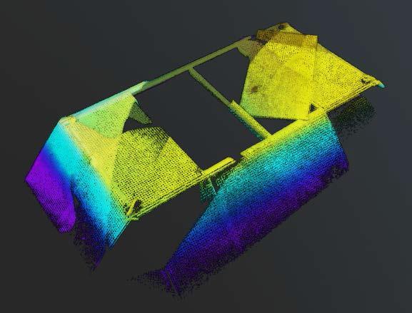
7 Worksite


8 Seabed deployment

9 Seabed deployment West structure, Target 01 Compatt position: E N Heading (T) East structure, Target 02 Compatt position: E N Heading (T) Hub 14 Hub 1 Hub 13 Structure north Depth loop pads Hub 2 Compatt 6206 (Structure CRP) Hub 12 Depth loop pads Structure north Hub 3 Compatt 6205 (Structure CRP) Hub 11 Hub 4


10 Point cloud images pseudo structures Point cloud from single run 2 runs overlaid on top of each other
11 Point cloud fly through pseudo structures


12 Point cloud images existing structure at TUC

13 Results vertical hubs Vertical Hub 3 to 13 (big hub) Laser Avg SD Connect LBL Delta Horizontal Distance Vertical Distance Bearing Hub 3 Pitch Hub 3 Roll Hub 13 Pitch Hub 13 Roll Vertical Hub 2 to 12 (small hub) Laser Avg SD Connect LBL Delta Horizontal Distance Vertical Distance Bearing Hub 2 Pitch Hub 2 Roll Hub 12 Pitch Hub 12 Roll Laser results are an average of both inferred and direct metrology results from 2 runs (in same direction)

14 Results horizontal hubs Horizontal Hub 1 to 11 Laser Avg SD Connect LBL Delta Horizontal Distance Vertical Distance Bearing Hub 1 Heading Hub 1 Pitch Hub 11 Heading Hub 11 Pitch Horizontal Hub 4 to 14 Laser Avg SD Connect LBL Delta Horizontal Distance Vertical Distance Bearing Hub 4 Heading Hub 4 Pitch Hub 14 Heading Hub 14 Pitch Laser results are an average of inferred metrology results from 2 runs (in same direction)
15 Results summary Measurement Absolute Avg Horizontal Distance Vertical Separation Pitch 0.16 Roll 0.39 Heading 0.15 Measurement Avg Horizontal Distance Vertical Separation Pitch Roll 0.03 Heading 0.07 Operational circumstances limited the time available We weren t able to complete the full program Results are only from two usable runs in same direction normal procedure is four runs, two in each direction Structures were passed in opposite sides of the laser scan normal procedure is to have hubs in centre of scan Results based on dimensional control of mounting bracket normal procedure Higher numbers for vertical separation and roll likely caused by residual misalignment artefact between INS and laser Despite the extreme conditions and not being able to carry out our full program, results are within metrology tolerance of the truth

16 Track record highlights who is using it


17 Track record - MBARI


18 Track record UTEC / McDermott


19 Track record - NOAA U-576 Mapping


20 Track record ADUS DeepOcean

21 Track record ADUS DeepOcean

 affecting operation is minimal can fly closer.")

22 Conclusions SPRINT for dynamic laser scanning Benefits of going dynamic Ultra fast for wide area hi-res mapping, inspection and metrology. Less than 2 hour of seabed time for metrology is possible. Contactless and without the requirement for previous dimensional control. Turbidity (visibility) affecting operation is minimal can fly closer. Trusted QC from comparison with 6G acoustic ranges. Challenges Complex INS / DVL / acoustic system and algorithms to achieve centimetric positioning. This is solved with Sonardyne s unique ability to merge and postprocess all sensors at the raw data level. Sonardyne understands how to optimally operate all of it. + + = SUCCESS
23 Thank you! Visit us on Stand 44 Simon Waterfield Survey Support Group Manager, Sonardyne International Ltd.
Improved Operational Efficiency with Laser Scanning Scott Gray, Operations Manager, Seatronics Ltd.
 Improved Operational Efficiency with Laser Scanning Scott Gray, Operations Manager, Seatronics Ltd. Overview ULS Underwater Laser Systems Trade-offs with Sonar and laser System Operation Results Preview
Improved Operational Efficiency Through 3D Laser Scanning Techniques. Presented by Grace Chia, Sales Engineer, Seatronics
 Improved Operational Efficiency Through 3D Laser Scanning Techniques Presented by Grace Chia, Sales Engineer, Seatronics About Us SEATRONICS The Marine Technology Specialists; Market leaders in provision
INS aided subsurface positioning for ROV surveys
 INS aided subsurface positioning for ROV surveys M. van de Munt, Allseas Engineering B.V., The Netherlands R van der Velden, Allseas Engineering B.V., The Netherlands K. Epke, Allseas Engineering B.V.,
TAKING LIDAR SUBSEA. Adam Lowry, Nov 2016
 TAKING LIDAR SUBSEA Adam Lowry, Nov 2016 3D AT DEPTH Based in the technology hub of Boulder, Colorado, 3D at Depth is dedicated to the development of underwater laser measurement sensors and software Patented
Deepwater Spoolpiece Metrology and INS
 Deepwater Spoolpiece Metrology and INS ir. Wilbert Brink AVANS Hogeschool - 16 June 2009 Introduction What is a deepwater spoolpiece metrology? What is the classical way of doing a metrology? How can we
Using Close Range Photogrammetry to meet Offshore Platform Construction and Installation Requirements
 Using Close Range Photogrammetry to meet Offshore Platform Construction and Installation Requirements Simon Manser, BP Exploration for Hydro14 Clair Phase II Project - Clair Ridge UKCS West of Shetland
10 Years of Implied Metrology. Stewart Cannon 4D Nav
 10 Years of Implied Metrology Stewart Cannon 4D Nav Green Canyon Area of Gulf of Mexico 150 miles south of New Orleans First oil 2007 Oil and Gas exported via Caesar and Cleopatra pipeline systems Two
New underwater contactless metrology and inspection approach using photogrammetric integrated system
 New underwater contactless metrology and inspection approach using photogrammetric integrated system The leading Edge of Value-Based Subsea Inspection, SUT, Aberdeen, 1 st November 2017 1 ORUS 3D SYSTEM
DYNAMIC POSITIONING CONFERENCE September 16-17, Sensors
 DYNAMIC POSITIONING CONFERENCE September 16-17, 2003 Sensors An Integrated acoustic positioning and inertial navigation system Jan Erik Faugstadmo, Hans Petter Jacobsen Kongsberg Simrad, Norway Revisions
PRODUCT BROCHURE SCANNING SOLUTIONS PORTABLE LASER SCANNING WITH THE LEICA ABSOLUTE TRACKER
 PRODUCT BROCHURE SCANNING SOLUTIONS PORTABLE LASER SCANNING WITH THE LEICA ABSOLUTE TRACKER INTRODUCTION THE RIGHT SOLUTION FOR EVERY SCANNING APPLICATION Hexagon Manufacturing Intelligence s portable
Delph. Seabed Mapping Software Suite FEATURES ABOUT DELPH SOFTWARE SUITE BENEFITS APPLICATIONS
 Delph Seabed Mapping Software Suite Delph Seismic, Delph Sonar and Delph Mag are complete software packages with dedicated acquisition, processing and interpretation components. They operate with any sidescan
Product Guide. Outstanding Performance in Underwater Technology
 Product Guide Outstanding Performance in Underwater Technology Our local representatives and resellers Introduction to Tritech Tritech International Limited [Tritech], A Moog Inc. Company, is a high-technology
Boresight alignment method for mobile laser scanning systems
 Boresight alignment method for mobile laser scanning systems P. Rieger, N. Studnicka, M. Pfennigbauer RIEGL Laser Measurement Systems GmbH A-3580 Horn, Austria Contents A new principle of boresight alignment
Alignment of Centimeter Scale Bathymetry using Six Degrees of Freedom
 Alignment of Centimeter Scale Bathymetry using Six Degrees of Freedom Ethan Slattery, University of California Santa Cruz Mentors: David Caress Summer 2018 Keywords: point-clouds, iterative closest point,
Transducer and LBL calibration - Integrated functions in HiPAP systems
 Transducer and LBL calibration - Integrated functions in HiPAP systems Dynamic Positioning Conference, Houston, September 17-18 2002 arranged by 1 Calibration of transducer alignment and of LBL array This
Three-Dimensional Laser Scanner. Field Evaluation Specifications
 Stanford University June 27, 2004 Stanford Linear Accelerator Center P.O. Box 20450 Stanford, California 94309, USA Three-Dimensional Laser Scanner Field Evaluation Specifications Metrology Department
Compatt 5 Transponder
 SONARDYNE NAVIG VIGATION SYSTEMS Compatt 5 Transponder The world s most capable acoustic navigation transponder Designed for 1 Compatt 5 Compatt, the Computing and telemetry transponder, has been the market-leader
PCMM System Specifications Leica Absolute Tracker and Leica T-Products
 www.leica-geosystems.com/metrology PCMM System Specifications Leica Absolute Tracker and Leica T-Products Leica Absolute Tracker accuracy The measurement uncertainty of a coordinate U xyz is defined as
PCMM System Specifications Leica Absolute Tracker and Leica T-Products
 www.leica-geosystems.com/metrology PCMM System Specifications Leica Absolute Tracker and Leica T-Products Leica Absolute Tracker accuracy Feature Benefit The measurement uncertainty of a coordinate U xyz
Who we are Swathe Services offers: Equipment Sales Equipment Rental Experience Hydrographic Surveyors Turn-key survey support
 Swathe Services our results speak for themselves Who we are Swathe Services offers: Equipment Sales Equipment Rental Experience Hydrographic Surveyors Turn-key survey support Dissertation Title High Resolution
US foundry Bradken implements optical measuring technology
 Application Note US foundry Bradken implements optical measuring technology Location / country: Tacoma / Washington, USA GOM systems: ATOS Triple Scan, TRITOP GOM software: ATOS Professional Sector: Power
Leica Absolute Trackers
 PRODUCT BROCHURE Leica Absolute Trackers Probing Solutions Leica Absolute Tracker AT402 and B-Probe ENTRY-LEVEL ULTRA-PORTABLE Probing System The Leica B-Probe is a handheld and battery-powered point probing
Introducing. GeoSLAM. The experts in go anywhere 3D mobile mapping technology. The Company. The Technology. The Applications. Strategic Partnerships
 Introducing GeoSLAM The experts in go anywhere 3D mobile mapping technology The Company The Technology The Applications Strategic Partnerships The Company Multipurpose Presentation Template 2 About Us
Simplicity is the new black: The BLK360 story
 Simplicity is the new black: The BLK360 story Vanda KADLECIKOVA Leica Geosystems Heerbrugg, Switzerland E-mail: vanda.kadlecikova@leica-geosystems.com Abstract Meet the game changer. The new Leica BLK360
1.1.1 Orientation Coordinate Systems
 1.1.1 Orientation 1.1.1.1 Coordinate Systems The velocity measurement is a vector in the direction of the transducer beam, which we refer to as beam coordinates. Beam coordinates can be converted to a
600M SPECTRE FIBEROPTIC ROV SYSTEM
 Science Class ROV 600M SPECTRE FIBEROPTIC ROV SYSTEM General Specifications Dimensions: 60.0 L x 35.0 W x 33.0 H Weight: 795 pounds Payload: 30-75 pounds Tilt Assembly: 270 Pan - 90 Tilt Forward Thrust:
Performance Evaluation of Optech's ALTM 3100: Study on Geo-Referencing Accuracy
 Performance Evaluation of Optech's ALTM 3100: Study on Geo-Referencing Accuracy R. Valerie Ussyshkin, Brent Smith, Artur Fidera, Optech Incorporated BIOGRAPHIES Dr. R. Valerie Ussyshkin obtained a Ph.D.
Patch Test & Stability Check Report
 Patch Test & Stability Check Report Storebælt, 2009 SB Cable Project CT Offshore Final Report November, 2009 SB Cable Project November 2009 8-10 Teglbaekvej DK-8361 Hasselager Aarhus, Denmark Tel: +45
Quality Control with 4D Nav s QCView Software. Rig Move QA/QC Operations Using QCView. Case Study 1: Drillship Rig Move
 Quality Control with 4D Nav s QCView Software 4D Nav has introduced a software package designed to provide advanced QC capabilities for offshore operations. This paper describes some of the capabilities
NAVIPAC 4 INTRODUCTION AND WORKFLOW
 NAVIPAC 4 INTRODUCTION AND WORKFLOW Contents 1 Introduction to NaviPac... 3 2 Program Environment... 4 3 Hardware environment... 7 4 Workflow example... 8 4.1 Workflow: Creating a configuration... 9 4.1.1
Motion estimation of unmanned marine vehicles Massimo Caccia
 Motion estimation of unmanned marine vehicles Massimo Caccia Consiglio Nazionale delle Ricerche Istituto di Studi sui Sistemi Intelligenti per l Automazione Via Amendola 122 D/O, 70126, Bari, Italy massimo.caccia@ge.issia.cnr.it
Automating Data Alignment from Multiple Collects Author: David Janssen Optech Incorporated,Senior Technical Engineer
 Automating Data Alignment from Multiple Collects Author: David Janssen Optech Incorporated,Senior Technical Engineer Stand in Presenter: David Collison Optech Incorporated, Regional Sales Manager Introduction
Joining 4.0: Smart Manufacturing Joining Sub Platform 7 th General Assembly. Dr Simon McCaldin 16 th Sept 2017
 Joining 4.0: Smart Manufacturing Joining Sub Platform 7 th General Assembly Dr Simon McCaldin 16 th Sept 2017 i4.0: Digital Manufacturing Put simply Industry 4.0 represents the coming fourth industrial
NAVIPAC/NAVISCAN WITH EDGETECH 6205
 NAVIPAC/NAVISCAN WITH EDGETECH 6205 Last update: 19/11/2015 Version: 1.0 Contents 1 Scope of the document... 3 2 NaviScan Configuration... 3 2.1 Configuring the instruments from EdgeTech... 3 2.1.1 Configuring
1.0 SIDESCAN SONAR SYSTEMS
 1.0 SIDESCAN SONAR SYSTEMS 1.1 - Geoacoustics 160D Dual Frequency Sidescan Sonar System (1000m rated) inclusive of :- 1 x Geoacoustics SS941 Transceiver 1 x Geoacoustics 159D Towfish (100/410Khz) 1 x Deck
APPLANIX PRODUCTS AND SOLUTIONS FOR MOBILE MAPPING AND POSITIONING CAPTURE EVERYTHING. POSPac MMS HYDRO 08 November 2008
 APPLANIX CAPTURE EVERYTHING POSPac MMS HYDRO 08 November 2008 Accurate Post Processed Position & Orientation For Modern Port Survey Operations. Increasing use of sonar & laser survey equipment with sub-centimetre
Proceedings of Western Dredging Association and Texas A&M University Center for Dredging Studies' "Dredging Summit and Expo 2015"
 Proceedings of Western Dredging Association and Texas A&M University Center for Dredging Studies' DYNAMIC UNDERWATER 3D SURVEY AND MONITORING DURING RECENT PLATFORM DREDGING OPERATION: REDUCING RISK AND
Introduction to Inertial Navigation and Kalman filtering
 Introduction to Inertial Navigation and Kalman filtering INS Tutorial, Norwegian Space Centre 2008.06.09 Kenneth Gade, FFI Outline Notation Inertial navigation Aided inertial navigation system (AINS) Implementing
SLiP. Source Line Processing
 SLiP Source Line Processing What is SLiP SLiP (Source Line Processing) is Windows based software for computing source positions. SLiP has been specifically written for OBC type seismic surveys. It deals
UNDERWATER ACOUSTIC MODEMS PRODUCT INFORMATION GUIDE
 UNDERWATER ACOUSTIC MODEMS PRODUCT INFORMATION GUIDE EvoLogics Underwater Acoustic Modems EvoLogics underwater acoustic modems provide full-duplex digital communication using EvoLogics' patented S2C (Sweep-
Evaluating the Performance of a Vehicle Pose Measurement System
 Evaluating the Performance of a Vehicle Pose Measurement System Harry Scott Sandor Szabo National Institute of Standards and Technology Abstract A method is presented for evaluating the performance of
METHODS FOR PERFORMANCE EVALUATION OF SINGLE AXIS POSITIONING SYSTEMS: POINT REPEATABILITY
 METHODS FOR PERFORMANCE EVALUATION OF SINGLE AXIS POSITIONING SYSTEMS: POINT REPEATABILITY Nathan Brown 1 and Ronnie Fesperman 2 1 ALIO Industries. Wheat Ridge, CO, USA 2 National Institute of Standards
UndErwatEr acoustic modems. product information GUidE
 UndErwatEr acoustic modems product information GUidE evologics s2c R - series underwater acoustic modems EvoLogics S2CR - series underwater acoustic modems provide full-duplex digital communication using
NEW. Very high-speed profile measurement for industrial in line applications. 2D/3D profile sensor SENSORS & SYSTEMS
 SENSORS & SYSTEMS SENSORS & SYSTEMS By far the better solution PRINCIPLE NEW 28 Very high-speed profile measurement for industrial in line applications. High accuracy and very high frame frequency thanks
Insertion Device Alignment for the Diamond Light Source
 Insertion Device Alignment for the Diamond Light Source A. Mariani Diamond Light Source, Chilton, Didcot, Oxon. OX11 0DE, UK This paper covers the survey and alignment techniques selected for the build
SHALLOW SOUNDING BATHYMETRIC USING MULTIBEAM ECHOSOUNDER AND TOPOGRAPHIC LASER SCANNER
 SHALLOW SOUNDING BATHYMETRIC USING MULTIBEAM ECHOSOUNDER AND TOPOGRAPHIC LASER SCANNER BY : NURSUGI, TRI PATMASARI & KHAFID GEOSPASIAL INFORMATION AGENCY AMSTERDAM, 11-14 NOVEMBER 2014 Indonesia coastline
GI-Eye II GPS/Inertial System For Target Geo-Location and Image Geo-Referencing
 GI-Eye II GPS/Inertial System For Target Geo-Location and Image Geo-Referencing David Boid, Alison Brown, Ph. D., Mark Nylund, Dan Sullivan NAVSYS Corporation 14960 Woodcarver Road, Colorado Springs, CO
OFERTA O120410PA CURRENT DATE 10/04//2012 VALID UNTIL 10/05/2012 SUMMIT XL
 OFERTA O120410PA CURRENT DATE 10/04//2012 VALID UNTIL 10/05/2012 SUMMIT XL CLIENT CLIENT: Gaitech REPRESENTANT: Andrew Pether MAIL: andyroojp@hotmail.com PRODUCT Introduction The SUMMIT XL has skid-steering
MONITORING OF THE SUBMERGED STRUCTURES OF DAMS
 MONITORING OF THE SUBMERGED STRUCTURES OF DAMS E Isomäki 1 and K Hänninen 2 1. ELY Centre for Häme, Hämeenlinna, Finland 2. VRT Finland, Jyväskylä, Finland PUBLISHED IN ICOLD SYMPOSIUM 2016, SOUTH AFRICA
Laser profile sensor, laser scanner 2D/3D for beads and grooves
 Laser profile sensor, laser scanner 2D/3D for beads and grooves Industrial laser profile sensor, 2D/3D laser scanner for fast CMOS profile measurement and laser line for beads and grooves, dimension, position
SP25M The world s most compact and versatile scanning probe system
 SP25M The world s most compact and versatile scanning probe system 1 Issue 10 technology SP25M - the world s most compact and versatile scanning probe system SP25M brings exciting new benefits SP25M encompasses
Ocean High Technology Institute, Inc. Tadahiko Katsura Japan Hydrographic Association
 Technical Aspects of Marine Scientific Research for Continental Shelf Outer Limits: Advanced Method of Multi-beam Data Processing to Obtain Detailed and Precise Bathymetry Yasutaka Yokoi Ocean High Technology
William E. Dietrich Professor 313 McCone Phone Fax (fax)
") February 13, 2007. Contact information William E. Dietrich Professor 313 McCone Phone 510-642-2633 Fax 510-643-9980 (fax) bill@eps.berkeley.edu Project location: Northwest of the Golden Gate Bridge, San
February 13, 2007. Contact information William E. Dietrich Professor 313 McCone Phone 510-642-2633 Fax 510-643-9980 (fax) bill@eps.berkeley.edu Project location: Northwest of the Golden Gate Bridge, San
Abstract. Introduction
 The efficient calculation of the Cartesian geometry of non-cartesian structures J.M. Freeman and D.G. Ford Engineering Control and Metrology Research Group, The School of Engineering, University of Huddersfield.
COLLABORATION is KEY
 AN AERIAL ADVANTAGE COLLABORATION is KEY LIVING AND WORKING IN A WORLD OF FAST TECHNOLOGICAL ADVANCEMENT, COLLABORATION OF SKILLS IS BECOMING MORE COMMONPLACE. DTM Technologies Ltd and Seahawk AP have
W D-0049/004 EN
 September 21, 2011 Contact Ground Survey Report, Lidar Accuracy Report, & Project Report New Madrid Seismic Zone Northeast of Memphis, Tennessee Contract Number: W91278-09D-0049/004 EN Project: C-10-026
Feature Based Navigation for a Platform Inspection AUV
 Feature Based Navigation for a latform Inspection AUV ehar Tangirala* Chris Debrunner Walter Feldman Alan Fettinger Locheed Martin 00 E.7 th treet Riviera Beach, FL 33404 (56) 47-4336 *sehar.tangirala@lmco.com
ORBIS MODERN ROLLING-ELEMENT BEARING ANALYSIS SOFTWARE
 ORBIS MODERN ROLLING-ELEMENT BEARING ANALYSIS SOFTWARE OVERVIEW Introduction ORBIS is a computer program to solve the nonlinear elastic behavior of rollingelement ball bearings. The model considers each
Rigorous Scan Data Adjustment for kinematic LIDAR systems
 Rigorous Scan Data Adjustment for kinematic LIDAR systems Paul Swatschina Riegl Laser Measurement Systems ELMF Amsterdam, The Netherlands 13 November 2013 www.riegl.com Contents why kinematic scan data
Implementation of underwater precise navigation system for a remotely operated mine disposal vehicle
 International Journal of Ocean System Engineering 1(2) (211) 12-19 DOI 1.74/IJOSE.211.1.2.12 International Journal of Ocean System Engineering Implementation of underwater precise navigation system for
InteLAS Family of Mobile LiDAR Systems
 InteLAS Family of Mobile LiDAR Systems September 2015 What we do ilinks Geosolutions LLC Hydrographic surveying and seabed modeling Topographic surveying and mobile mapping Systems engineering and integration
Navigational Aids 1 st Semester/2007/TF 7:30 PM -9:00 PM
 Glossary of Navigation Terms accelerometer. A device that senses inertial reaction to measure linear or angular acceleration. In its simplest form, it consists of a case-mounted spring and mass arrangement
DEVICE CONFIGURATION INSTRUCTIONS. WinFrog Device Group:
 WinFrog Device Group: Device Name/Model: Device Manufacturer: Device Data String(s) Output to WinFrog: WinFrog Data String(s) Output to Device: WinFrog Data Item(s) and their RAW record: ROV Olympian T2
TerraMatch. Introduction
 TerraMatch Introduction Error sources Interior in LRF Why TerraMatch? Errors in laser distance measurement Scanning mirror errors Exterior in trajectories Errors in position (GPS) Errors in orientation
Example of Monitoring Requirement
 CEGE Department 3DIMPact of Civil, Environmental & Geomatic Engineering (CEGE) 3D Imaging, Metrology, Photogrammetry Applied Coordinate Technologies (3DIMPact) Optical non-contact railway track measurement
UNIT IV - Laser and advances in Metrology 2 MARKS
 UNIT IV - Laser and advances in Metrology 2 MARKS 81. What is interferometer? Interferometer is optical instruments used for measuring flatness and determining the lengths of slip gauges by direct reference
REMOTE SENSING LiDAR & PHOTOGRAMMETRY 19 May 2017
 REMOTE SENSING LiDAR & PHOTOGRAMMETRY 19 May 2017 SERVICES Visual Inspections Digital Terrain Models Aerial Imagery Volume Computations Thermal Inspections Photo maps Aerial Video Training & Consultancy
Camera Drones Lecture 2 Control and Sensors
 Camera Drones Lecture 2 Control and Sensors Ass.Prof. Friedrich Fraundorfer WS 2017 1 Outline Quadrotor control principles Sensors 2 Quadrotor control - Hovering Hovering means quadrotor needs to hold
Gregory Walsh, Ph.D. San Ramon, CA January 25, 2011
 Leica ScanStation:: Calibration and QA Gregory Walsh, Ph.D. San Ramon, CA January 25, 2011 1. Summary Leica Geosystems, in creating the Leica Scanstation family of products, has designed and conducted
Polygon scanner based ultra-short pulse laser processing in roll-to-roll manufacturing
 Polygon scanner based ultra-short pulse laser processing in roll-to-roll manufacturing Development of high speed ultra-short pulse laser ablation process integrated into a roll-to-roll machine Name Surname,
DATA SHEET DEA GLOBAL SILVER 09.XX XX.10
 DATA SHEET DEA GLOBAL SILVER 09.XX.08-12.XX.10 Classic Performance Advantage Temperature Compensation Optional CLIMA CLIMA CLIMA Performance Environment Standard: 18 22 C Option CLIMA: 16 26 C Standard:
( 83P UDP/IP Ethernet Datagram,.83P File Format )
") IMAGENEX TECHNOLOGY CORP. DeltaT - 83P PROFILE POINT OUTPUT ( 83P UDP/IP Ethernet Datagram,.83P File Format ) For each ping, the following bytes are output during the 83P UDP datagram. If recording to
IMAGENEX TECHNOLOGY CORP. DeltaT - 83P PROFILE POINT OUTPUT ( 83P UDP/IP Ethernet Datagram,.83P File Format ) For each ping, the following bytes are output during the 83P UDP datagram. If recording to
IMPROVEMENT OF AIRCRAFT MECHANICAL DAMAGE INSPECTION WITH ADVANCED 3D IMAGING TECHNOLOGIES
 IMPROVEMENT OF AIRCRAFT MECHANICAL DAMAGE INSPECTION WITH ADVANCED 3D IMAGING TECHNOLOGIES MARK MAIZONNASSE 60TH A4A NDT FORUM SEPTEMBER 2017, FORT LAUDERDALE, FL, USA BRIDGING PHYSICAL AND DIGITAL WORLDS
The Joys of Smoothing
 The Joys of Smoothing Are B. Willumsen and Øyvind Hegrenæs Kongsberg Maritime Strandpromenaden 5 9 Horten, Norway Abstract-Navigation post-processing or smoothing is the process of optimizing all navigation
Selection and Integration of Sensors Alex Spitzer 11/23/14
 Selection and Integration of Sensors Alex Spitzer aes368@cornell.edu 11/23/14 Sensors Perception of the outside world Cameras, DVL, Sonar, Pressure Accelerometers, Gyroscopes, Magnetometers Position vs
Data, Data, Everywhere. We are now in the Big Data Era.
 Data, Data, Everywhere. We are now in the Big Data Era. CONTENTS Background Big Data What is Generating our Big Data Physical Management of Big Data Optimisation in Data Processing Techniques for Handling
BLAZE 600M HIGH-ACCURACY BLUE LIGHT MEASUREMENT SYSTEM PRODUCT BROCHURE
 BLAZE 600M HIGH-ACCURACY BLUE LIGHT MEASUREMENT SYSTEM PRODUCT BROCHURE BLAZING SPEED, DAZZLING PERFORMANCE The BLAZE 600M portable blue light measurement system from Hexagon Manufacturing Intelligence
Exterior Orientation Parameters
 Exterior Orientation Parameters PERS 12/2001 pp 1321-1332 Karsten Jacobsen, Institute for Photogrammetry and GeoInformation, University of Hannover, Germany The georeference of any photogrammetric product
AICON MoveInspect XR8
 AICON MoveInspect XR8 PORTABLE. ROBUST. ACCURATE. PRODUCT BROCHURE THE NEW BENCHMARK FOR INSPECTION, TRACKING AND POSITIONING Today, every company has to meet the challenge to develop products within shorter
(Subsea) Keith Vickery Zupt LLC
 Keith Vickery Zupt LLC") (Subsea) Keith Vickery Zupt LLC kv@zupt.com Offshore subsea infrastructure surveys (pipeline inspection, well, XT, and manifold inspections) are required to ensure compliance with both internal operator,
(Subsea) Keith Vickery Zupt LLC kv@zupt.com Offshore subsea infrastructure surveys (pipeline inspection, well, XT, and manifold inspections) are required to ensure compliance with both internal operator,
3D Hydrographic Mapping for Real-Time Underwater Assessment Blair Cunningham, President of Technology Lakeland, Florida
 3D Hydrographic Mapping for Real-Time Underwater Assessment Blair Cunningham, President of Technology Lakeland, Florida Marine Products Solution Experts Salt Lake City, UT Lakeland, FL Edinburgh, UK Portland,
3D CAD Systems: 3D Scanners, Reverse Engineering & Inspection Presenter
 3D CAD Systems: 3D Scanners, Reverse Engineering & Inspection Presenter Chris Duchaine Application Engineer Agenda Why 3D Scan? Artec 3D Technology Inspection Reverse Engineering Q&A Why 3D Scanning? 3D
BEFORE YOU BUY: SEVEN CRITICAL QUESTIONS TO ASK ABOUT LASER SCANNERS. Robert Gardiner
 BEFORE YOU BUY: SEVEN CRITICAL QUESTIONS TO ASK ABOUT LASER SCANNERS Robert Gardiner Table of Contents Introduction... 3 Horizontal and Vertical Angular Accuracies... 4 Movement Tracking... 6 Range Limitations...
PRODUCT BROCHURE TIGO SF. 3D coordinate measuring machine for the shop floor
 PRODUCT BROCHURE TIGO SF 3D coordinate measuring machine for the shop floor 2 TIGO SF Coordinate measuring machine for the shop floor ONE FLOW WITH TIGO SF In production you are aiming at a constant flow
Optically jointed probing systems for large volume coordinate metrology. Stephen Kyle
 Optically jointed probing systems for large volume coordinate metrology Stephen Kyle Concepts presentation "Walk around" probing is here but does it do enough? Leica T-System, API Intelliprobe, Metris
Enabling Rapid Multitenant Data Centre (MTDC) Connections
 Connections") Enabling Rapid Multitenant Data Centre (MTDC) Connections At Corning, we understand the challenges associated with outsourced facilities, whether you re an MTDC/ cloud provider or an enterprise client.
Enabling Rapid Multitenant Data Centre (MTDC) Connections At Corning, we understand the challenges associated with outsourced facilities, whether you re an MTDC/ cloud provider or an enterprise client.
S-650 Coupling Alignment System
 S-650 Coupling A new generation of 5-axis, real-time coupling alignment systems. Geometric Alignment Laser Systems The Best Choice in Coupling Alignment is Easy to See 1 Largest target cell size on the
LEICA ABSOLUTE TRACKER AT960
 PRODUCT BROCHURE Absolute portability. Absolute speed. Absolute accuracy. ABSOLUTE PORTABILITY QUALITY AND PRODUCTIVITY ON THE MOVE The Leica Absolute Tracker AT960 from Hexagon Metrology is the first
Video inspection systems
 Video inspection systems See the Quality Over70 Years Of Manufacturing scherr-tumico Precision Instruments MADE IN U.S.A. INDEX Index video InSPEcTIOn SySTEmS 8700 SERIES... 3-4 9100 SERIES... 5-6 9700
Integration between NaviPac and CDL MiniPOS
 Integration between NaviPac and CDL MiniPOS The program The program is named NPCDLAiding.exe and found at \eiva\navipac\bin. It has to be started manually as part of the NaviPac online system, and we recommend
WinH-ADCP User s Guide
 WinH-ADCP User s Guide P/N 95B-6000-00 (January 2005) RD Instruments Acoustic Doppler Solutions Table of Contents 1 Introduction... 1 1.1 System Requirements...1 1.2 Software Installation...2 1.3 Conventions
3D profiler for contactless probe card inspection. Rob Marcelis
 3D profiler for contactless probe card inspection Rob Marcelis 1 Content Introduction Objectives Challenges Basics DOE Results Data transformation Advantages/disadvantages Summary conclusions Follow up
Introduction to Inertial Navigation (INS tutorial short)
") Introduction to Inertial Navigation (INS tutorial short) Note 1: This is a short (20 pages) tutorial. An extended (57 pages) tutorial that also includes Kalman filtering is available at http://www.navlab.net/publications/introduction_to
Introduction to Inertial Navigation (INS tutorial short) Note 1: This is a short (20 pages) tutorial. An extended (57 pages) tutorial that also includes Kalman filtering is available at http://www.navlab.net/publications/introduction_to
Range Sensing Based Autonomous Canal Following Using a Simulated Multi-copter. Ali Ahmad
 Range Sensing Based Autonomous Canal Following Using a Simulated Multi-copter Ali Ahmad MS Student of Electrical Engineering Laboratory for Cyber Physical Networks and Systems LUMS School of Science &
Localization Refinement for Indoor Modeling System Using Lasers and Images
 Localization Refinement for Indoor Modeling System Using Lasers and Images Overview Matthew Carlberg (carlberg@eecsberkeleyedu) Avideh Zakhor (avz@eecsberkeleyedu) Video and Image Processing Laboratory
Dedicated Software Algorithms for 3D Clouds of Points
 Dedicated Software Algorithms for 3D Clouds of Points Introduction AQSENSE develops and commercializes 3D image acquisition and processing technologies that allow high speed in-line 100% production inspection,
New Approach in Non- Contact 3D Free Form Scanning
 New Approach in Non- Contact 3D Free Form Scanning Contents Abstract Industry Trends The solution A smart laser scanning system Implementation of the laser scanning probe in parts inspection Conclusion
Teledyne PDS. Multibeam Calibration. Version January Teledyne RESON B.V. Stuttgartstraat AS Rotterdam The Netherlands
 Multibeam Calibration Teledyne PDS Version 2.0.4 January 2017 Teledyne RESON B.V. Stuttgartstraat 42-44 3047 AS Rotterdam The Netherlands Tel.: +31 (0)10 245 15 00 www.teledyne-reson.com Teledyne RESON
Polymer Micro-Optics for Today s Compact Photonic Devices
 Polymer Micro-Optics for Today s Compact Photonic Devices Lynn Dobosz - North America Sales & Business Development for the Opto-Electronic Systems business unit of the Optical Systems division of Jenoptik
5 member consortium o University of Strathclyde o Wideblue o National Nuclear Laboratory o Sellafield Ltd o Inspectahire
 Summan, Rahul and Mathur, Neha and Dobie, Gordon and West, Graeme and Marshall, Stephen and Mineo, Carmelo and MacLeod, Charles Norman and Pierce, Stephen and Kerr, William (2016) Mosaicing for automated