What's New in ecognition 9
|
|
|
- Alexina Manning
- 5 years ago
- Views:
Transcription

1 Christian Weise Product Manager APRIL 2016 What's New in ecognition 9
2 Introduction

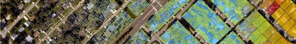
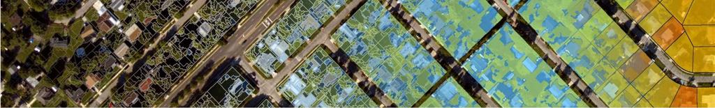
3 Background ecognition Suite Advanced analysis software and development environment available for geospatial applications Enables users to create feature extraction or change detections solutions to transform geospatial data into geoinformation Tree Map Impervious Map Land Cover Map Elevation Data Image Data Real World


4 Overview ecognition Suite offers three different components which can be used stand-alone or in combination to cover even the most challenging fully automatic and semi-automated production workflows ecognition Developer: development & analysis environment for applications ecognition Architect: front-end for applications created in Developer ecognition Architect ecognition Developer ecognition Architect ecognition Developer ecognition Server: processing environment ecognition Server ecognition Architect ecognition Server

5 Use Cases EXTRACT INFORMATION UPDATE INFORMATION
6 Unique Features


7 Geospatial Data Fusion Fuse and use a variety of geospatial data, such as images, point clouds and GIS vectors Use the full information potential of your data

 into computer understandable code")
8 Dynamic Analysis Input Raster Controlled with RuleSet Segmentation Classification GIS Analytics Abstraction Result Raster Vector Combines analysis steps Segmentation, Classification, Object Manipulation, and GIS Analytics dynamically Vector Point cloud Point cloud Report Unique approach to translate your mind model (why you see something in the data) into computer understandable code (ecognition Solution [Rule Set])
9 Highlights in Version 9.2


10 ecognition 9.2 Highlights Extended Multi-Core processing capabilities for faster project completion Advanced Data Support to reduce time taken in converting and loading data Extended Multi-Core processing capabilities
11 Extended Multi-Core processing capabilities Further multi-core enhancements in ecognition 9.2 allow users to utilize up to 8 CPU cores with selected functions that typically require longer processing times: Multi-Core powered Multiresolution Segmentation Multi-Core powered Template Matching Multi-Core powered Feature Calculations seconds The new multi-core capabilities maximize the power of computing hardware, reduce processing bottlenecks and allow users to complete projects in up to a third cores of the time taken with prior versions megapixel core 4 cores


12 Advanced Data Support Reduced time taken in converting and loading data - ecognition 9.2 includes a new driver for a faster import of JPEG2000 files and now supports the usage of MrSID image data. Furthermore a new point cloud driver allows the usages of compressed point clouds in the LASzip format. Direct access to latest image and point cloud compression technology Offers faster turnaround times for projects using the newest set of earth observation sensors JP2 SID LAZ
13 Highlights in Version 9.1


14 ecognition 9.1 Highlights Performance improvements, significantly reducing processing time Better utilization of GIS-Data in image analysis workflows Improved mapping capabilities for robust and accurate classification results Packaging and installation of customized ecognition applications Enhanced mobile mapping support for Trimble MX2 systems Application Packaging
 General trend in CPU development has moved from dual-core to")

15 Performance Improvement Feature: Multi-core support in Multiresolution Segmentation Background: Multiresolution Segmentation is the first and most successful object creation technique in the remote sensing market & the most timeconsuming process of an typical ecognition analysis (~45% of the overall processing time) General trend in CPU development has moved from dual-core to quador hex-core chips - parallel programming techniques can benefit from multiple cores directly Benefits: Performance improvements of up to 50% during object creation freeing time to focus on the interpretation of results and decision making Reduced overall processing time allowing users to faster produce results Utilize the power of current desktop systems by using up to 4 CPU cores
16 Performance Improvement Performance Increase [%] 50% 45% 40% 35% 30% 25% 20% 15% 10% 5% 0% 47% 48% 44% 47% 35% 34% 34% 34% (15k x 15k) (20k x 20k) (25k x 25k) (30k x 30k) Scene Size [pxl] Performance increase with 2 cpu cores Performance increase with 4 cpu cores
17 Better Utilization of GIS-Data Feature: New integrated GIS-techniques to inspect and analyze vector data, this includes: Buffering Conversions Distance calculations Benefits: Supports the dynamic combination of image and GIS analysis capabilities on a high level of automation which help reducing project turnaround times Further bridging the gap between GIS and Remote Sensing
 Samples represent the class examples and can be stored in GIS layers to save time if users want to")
 Benefits: Extend and transfer sample statistics for classifications make a reselection of sample areas superfluous and allowing users to faster produce results Combine sample statistics from")
18 Improved Mapping Capabilities Feature: Load, save and use sample statistics Background: Supervised learning algorithms analyzes spectral signatures obtained from sample areas and produces an classification model, which will be used for mapping ( convert pixel data into thematic information) Samples represent the class examples and can be stored in GIS layers to save time if users want to re-do or to modify the selection Problem is that new sample locations have to be selected for every new data set, because (beside atmospheric and spectral effects) they could not covered by the new scene(s) Benefits: Extend and transfer sample statistics for classifications make a reselection of sample areas superfluous and allowing users to faster produce results Combine sample statistics from different scenes offers the creation of transferable classification models which produce robust and accurate results

19 Other new features included Features: 1. Packaging and installation of customized ecognition applications 2. Enhanced mobile mapping support for Trimble MX2 systems Benefits: 1. Allows an easier roll out and commercialization of ecognition-based applications 2. Allow creation of mapping solution based on Trimble MX2 systems


20 Other new features included License Borrowing Customer Feedback Program
21 Highlights in Version 9.0
22 ecognition 9.0 Highlights Native Vector Handling Extend OBIA with GIS operations Template Matching Extend OBIA with computer vision based Object Detection Point Cloud Viewer Increase the productivity of creating Rule Sets JPEG2000 Support Integrate JPEG2000 images in OBIA Workflows Trusted Storage Flexible License Management Point Cloud Viewer JPEG 2000 Native Vector Handling and more Trusted Storage Template Matching
23 Native Vector Handling Efficient GIS data management inside ecognition, this includes Functions to visualize and inspect GIS vector data Common used GIS operations Algorithms to update and export GIS vectors This improved integration of GIS techniques into Remote Sensing workflows is further bridging the gap between the two domains


24 Native Vector Handling Visualize and inspect GIS vector layer (1) No Rasterization No Pixel Snapping

 Edit")

25 Native Vector Handling Visualize and inspect GIS vector layer (2) Edit Vector Layer Mixing dialog Vector related Features
26 Native Vector Handling Manipulate Vector Data (1) Combine GIS vector layers Input Union Subtract Intersect Difference Simplify/Smooth GIS vector layers Input Simplified Smoothed


27 Native Vector Handling Manipulate Vector Data (2) Orthogonalize GIS data layers i.e. Reshape Building Objects Integrate GIS data layers i.e. Combine Input/Result Layers Create GIS data layers i.e. Convert OBIA-Results into Vector Layers Update GIS data layers + i.e. Write Results back in Databases FileGDB +


28 Template Matching Extends the existing ecognition classification methods with computer vision based object detection, this includes GUI to collect Samples GUI to create and evaluate Templates Algorithm to execute Template Matching Provides additional value remote sensing experts by improving classification results and extending ecognition to new fields of use

")
29 Template Matching Template Matching Algorithm algorithm to execute matching procedure If standard deviation of the template image compared to the source image is small enough, template matching may be used Templates are most often used to identify printed characters, numbers, and other small objects (i.e. Trees)
 Functions to define and select")
 and generate")
30 Template Matching Template Editor (Template Generation) Functions to define and select Samples Functions to create Template(s) Functions to test Template(s) and generate additional Samples

31 Point Cloud Viewer Visualize Point Clouds for an easier and better data and result assessment Functions to render points by classification, intensity, RGB values Functions to define class colors This can significantly increase the productivity of creating rule sets as well as improving the classification quality


32 Trusted Storage License handling based on files is replaced with Trusted Storage Secure environment for license management Online license activation and re-hosting VM support Provides a Flexible ecognition License Management License Entitlement ID Activation Return


33 Summary View PCs CV based Object Detection Check PCs 3 rd Party Tools 3 rd Party Tools 3 rd Party Tools JPEG2000 Conversion Inspect Analyze Map Fusion Interpretation GIS Vectors Classified Points Statistics Generalize Results Combine Results Create Maps
34 Ordering, Availability, and Resources
35 Ordering, Availability, and Resources ecognition Suite 9.2 Release Date: 13 April 2016 Who s eligible? All users with a valid maintenance contract as of April 13 th, 2016 The software is available in the Customer Download Area: Get the Free Trial and learn more about Trimble ecognition on Visit the ecognition Community (more than users) to ask questions, follow discussions, download guided tours, and give feedback on
36 Contact Sales for Inquiry Find a Reseller Save up to 75% with EDU Discounts
What s New in ecognition 9.0. Christian Weise
 What s New in ecognition 9.0 Christian Weise Presenting ecognition 9 Release Date: March 2014 Who s eligible? All user with a valid ecognition maintenance contract Presenting ecognition 9 ecognition version
What s New in ecognition 9.0
 What s New in ecognition 9.0 Dr. Waldemar Krebs tranforming data into GIS ready information Trends in Earth Observation Increasing need for detailed, up-to-date information as a basis for planning and
RELEASE NOTES. Trimble ecognition Suite. Version July
 RELEASE NOTES Trimble ecognition Suite Version 9.2.1 July.2016 www.ecognition.com 1 Trimble Documentation ecognition 9.2 Release Notes Imprint and Version Document Version 9.2.1 Copyright 2016 Trimble
Trimble. ecognition. Release Notes
 Trimble ecognition Release Notes Trimble Documentation: ecognition 9.0 Release Notes Imprint and Version Document Version 9.0 Copyright 2014 Trimble Germany GmbH. All rights reserved. This document may
Image Analysis With the Definiens Software Suite
 Image Analysis With the Definiens Software Suite Definiens Enterprise Image Intelligence Andreas Kühnen, Senior Sales Manager Malte Sohlbach, Systems Engineering Manager August 2009 Definiens AG 1986 Prof.
DIGITAL IMAGE ANALYSIS. Image Classification: Object-based Classification
 DIGITAL IMAGE ANALYSIS Image Classification: Object-based Classification Image classification Quantitative analysis used to automate the identification of features Spectral pattern recognition Unsupervised
ERDAS IMAGINE THE WORLD S MOST WIDELY-USED REMOTE SENSING SOFTWARE PACKAGE
 PRODUCT BROCHURE ERDAS IMAGINE THE WORLD S MOST WIDELY-USED REMOTE SENSING SOFTWARE PACKAGE 1 ERDAS IMAGINE The world s most widely-used remote sensing software package 2 ERDAS IMAGINE The world s most
Object-Based Classification & ecognition. Zutao Ouyang 11/17/2015
 Object-Based Classification & ecognition Zutao Ouyang 11/17/2015 What is Object-Based Classification The object based image analysis approach delineates segments of homogeneous image areas (i.e., objects)
ENVI. Get the Information You Need from Imagery.
 Visual Information Solutions ENVI. Get the Information You Need from Imagery. ENVI is the premier software solution to quickly, easily, and accurately extract information from geospatial imagery. Easy
ArcGIS Pro: Image Segmentation, Classification, and Machine Learning. Jeff Liedtke and Han Hu
 ArcGIS Pro: Image Segmentation, Classification, and Machine Learning Jeff Liedtke and Han Hu Overview of Image Classification in ArcGIS Pro Overview of the classification workflow Classification tools
Submerged Aquatic Vegetation Mapping using Object-Based Image Analysis with Lidar and RGB Imagery
 Submerged Aquatic Vegetation Mapping using Object-Based Image Analysis with Lidar and RGB Imagery Victoria Price Version 1, April 16 2015 Submerged Aquatic Vegetation Mapping using Object-Based Image Analysis
ERDAS IMAGINE THE WORLD S MOST WIDELY-USED REMOTE SENSING SOFTWARE PACKAGE
 PRODUCT BROCHURE ERDAS IMAGINE THE WORLD S MOST WIDELY-USED REMOTE SENSING SOFTWARE PACKAGE 1 ERDAS IMAGINE The world s most widely-used remote sensing software package 2 ERDAS IMAGINE The Theworld s world
The Feature Analyst Extension for ERDAS IMAGINE
 The Feature Analyst Extension for ERDAS IMAGINE Automated Feature Extraction Software for GIS Database Maintenance We put the information in GIS SM A Visual Learning Systems, Inc. White Paper September
Hands on Exercise Using ecognition Developer
 1 Hands on Exercise Using ecognition Developer 2 Hands on Exercise Using ecognition Developer Hands on Exercise Using ecognition Developer Go the Windows Start menu and Click Start > All Programs> ecognition
Object Based Image Analysis: Introduction to ecognition
 Object Based Image Analysis: Introduction to ecognition ecognition Developer 9.0 Description: We will be using ecognition and a simple image to introduce students to the concepts of Object Based Image
Image Services for Elevation Data
 Image Services for Elevation Data Peter Becker Need for Elevation Using Image Services for Elevation Data sources Creating Elevation Service Requirement: GIS and Imagery, Integrated and Accessible Field
APPLICATION OF SOFTMAX REGRESSION AND ITS VALIDATION FOR SPECTRAL-BASED LAND COVER MAPPING
 APPLICATION OF SOFTMAX REGRESSION AND ITS VALIDATION FOR SPECTRAL-BASED LAND COVER MAPPING J. Wolfe a, X. Jin a, T. Bahr b, N. Holzer b, * a Harris Corporation, Broomfield, Colorado, U.S.A. (jwolfe05,
COMPONENTS. The web interface includes user administration tools, which allow companies to efficiently distribute data to internal or external users.
 COMPONENTS LASERDATA LIS is a software suite for LiDAR data (TLS / MLS / ALS) management and analysis. The software is built on top of a GIS and supports both point and raster data. The following software
Managing Image Data on the ArcGIS Platform Options and Recommended Approaches
 Managing Image Data on the ArcGIS Platform Options and Recommended Approaches Peter Becker Petroleum requirements for imagery and raster Traditional solutions and issues Overview of ArcGIS imaging capabilities
ENVI THE PREMIER SOFTWARE FOR EXTRACTING INFORMATION FROM GEOSPATIAL DATA
 ENVI THE PREMIER SOFTWARE FOR EXTRACTING INFORMATION FROM GEOSPATIAL DATA HarrisGeospatial.com BENEFITS Use one solution to work with all your data types Access a complete suite of analysis tools Customize
IMAGINE Objective. The Future of Feature Extraction, Update & Change Mapping
 IMAGINE ive The Future of Feature Extraction, Update & Change Mapping IMAGINE ive provides object based multi-scale image classification and feature extraction capabilities to reliably build and maintain
3D in the Browser with WebGL. Chris Andrews 3D Product Manager Javier Gutierrez 3D Product Engineer
 3D in the Browser with WebGL Chris Andrews 3D Product Manager Javier Gutierrez 3D Product Engineer Just sayin This is not a programming class Goal is to help you learn about a technology area that impacts
Trimble Business Center Software, v3.30
 Trimble Business Center Software, v3.30 We are pleased to announce a new version of the Trimble Business Center software, version 3.30. This new version includes over 30 new features and enhancements increasing
GE1LC7 - Getting to Know Bentley Descartes for Advanced Image Viewing, Editing and Processing
 GE1LC7 - Getting to Know Bentley Descartes for Advanced Image Viewing, Editing and Processing Inga Morozoff Introduction: Raster data is everywhere - whether you do CAD design, mapping or GIS analysis,
Trimble. ecognition. Release Notes
 Trimble ecognition Release Notes Trimble Documentation: ecognition 8.9 Release Notes Imprint and Version Document Version 8.9 Copyright 2013 Trimble Germany GmbH. All rights reserved. This document may
Getting Started With LP360
 Getting Started With LP360 12/22/2015 1 Contents What is LP360?... 3 System Requirements... 3 Installing LP360... 4 How to Enable the LP360 Extension... 4 How to Display the LP360 Toolbar... 4 How to Import
Feature Extraction from Imagery & Lidar. Kurt Schwoppe, Esri Mark Romero, Esri Gregory Bacon, Fairfax County
 Feature Extraction from & Lidar Kurt Schwoppe, Esri Mark Romero, Esri Gregory Bacon, Fairfax County Today s Speakers Image Processing Experts and Good Colleagues Kurt Schwoppe Industry Lead Esri Mark Romero
LiForest Software White paper. TRGS, 3070 M St., Merced, 93610, Phone , LiForest
 0 LiForest LiForest is a platform to manipulate large LiDAR point clouds and extract useful information specifically for forest applications. It integrates a variety of advanced LiDAR processing algorithms
Developing Imagery Apps Using the ArcGIS API for JavaScript and WebApp Builder. Naila Khan, Chayanika Khatua
 Developing Imagery Apps Using the ArcGIS API for JavaScript and WebApp Builder Naila Khan, Chayanika Khatua What are we talking about today Custom applications Map Viewer Web AppBuilder ArcGIS API for
IMAGERY FOR ARCGIS. Manage and Understand Your Imagery. Credit: Image courtesy of DigitalGlobe
 IMAGERY FOR ARCGIS Manage and Understand Your Imagery Credit: Image courtesy of DigitalGlobe 2 ARCGIS IS AN IMAGERY PLATFORM Empowering you to make informed decisions from imagery and remotely sensed data
An Introduction to Using Lidar with ArcGIS and 3D Analyst
 FedGIS Conference February 24 25, 2016 Washington, DC An Introduction to Using Lidar with ArcGIS and 3D Analyst Jim Michel Outline Lidar Intro Lidar Management Las files Laz, zlas, conversion tools Las
TERRA VISTA CONTENT CREATION
 CONTENT CREATION TERRA VISTA MAP. ROUTE. GENERATE Terra Vista is a terrain generation software that converts imagery, elevation, vectors, and other GIS data into optimized 3D simulation-ready virtual environments.
What s New in ArcGIS Server 10
 What s New in ArcGIS Server 10 Derek Law ArcGIS Server Product Management What s s new in ArcGIS Server 10? Agenda Highlights: Enhanced Web mapping More powerful server-based analysis Geo-collaboration
TERRA VISTA CONTENT CREATION MAP. ROUTE. GENERATE
 CONTENT CREATION MAP. ROUTE. GENERATE Terra Vista is a terrain generation software that converts imagery, elevation, vectors, and other geospatial data into optimized 3D simulation-ready virtual environments.
PhotoScan. Fully automated professional photogrammetric kit
 PhotoScan Fully automated professional photogrammetric kit Agisoft PhotoScan is a stand-alone photogrammetric software solution for automatic generation of dense point clouds, textured polygonal models,
SAP HANA Spatial Location-based business platform
 SAP HANA Spatial Location-based business platform Thomas Hammer, HANA Spatial Development April 19, 2018 SAP HANA Architecture Application development All Devices SAP, ISV and Custom Applications SAP HANA
Figure 1: Workflow of object-based classification
 Technical Specifications Object Analyst Object Analyst is an add-on package for Geomatica that provides tools for segmentation, classification, and feature extraction. Object Analyst includes an all-in-one
Introducing ArcScan for ArcGIS
 Introducing ArcScan for ArcGIS An ESRI White Paper August 2003 ESRI 380 New York St., Redlands, CA 92373-8100, USA TEL 909-793-2853 FAX 909-793-5953 E-MAIL info@esri.com WEB www.esri.com Copyright 2003
MrSID Plug-in for 3D Analyst
 LizardTech MrSID Plug-in for 3D Analyst User Manual Copyrights Copyright 2009 2010 LizardTech. All rights reserved. Information in this document is subject to change without notice. The software described
GEOBIA for ArcGIS (presentation) Jacek Urbanski
 Jacek Urbanski") GEOBIA for ArcGIS (presentation) Jacek Urbanski INTEGRATION OF GEOBIA WITH GIS FOR SEMI-AUTOMATIC LAND COVER MAPPING FROM LANDSAT 8 IMAGERY Presented at 5th GEOBIA conference 21 24 May in Thessaloniki.
GEOBIA for ArcGIS (presentation) Jacek Urbanski INTEGRATION OF GEOBIA WITH GIS FOR SEMI-AUTOMATIC LAND COVER MAPPING FROM LANDSAT 8 IMAGERY Presented at 5th GEOBIA conference 21 24 May in Thessaloniki.
Using Imagery for Intelligence Analysis
 2013 Esri International User Conference July 8 12, 2013 San Diego, California Technical Workshop Using Imagery for Intelligence Analysis Renee Bernstein Natalie Campos Esri UC2013. Technical Workshop.
Definiens. Professional 5. Reference Book. Definiens AG.
 Definiens Professional 5 Reference Book Definiens AG www.definiens.com 1 Algorithms Reference Imprint and Version Document Version 5.0.6.1 Copyright 2006 Definiens AG. All rights reserved. This document
PRODUCT BROCHURE IMAGESTATION HIGH VOLUME PHOTOGRAMMETRY AND PRODUCTION MAPPING
 PRODUCT BROCHURE IMAGESTATION HIGH VOLUME PHOTOGRAMMETRY AND PRODUCTION MAPPING UNPARALLELED PROCESSING, ACCURATE RESULTS FOR CAD AND GIS-BASED WORKFLOWS The ImageStation software suite enables digital
Bentley Descartes and what s new in Descartes V8i (SELECTseries 3) What is Bentley Descartes? 2011 Bentley Systems, Incorporated
 What is Bentley Descartes? 2011 Bentley Systems, Incorporated") Bentley Descartes and what s new in Descartes V8i (SELECTseries 3) Tom Stogdill Bentley Systems, Inc. What is Bentley Descartes? Image Processing Raster Geo-Referencing Advanced raster transformation (warping,
Bentley Descartes and what s new in Descartes V8i (SELECTseries 3) Tom Stogdill Bentley Systems, Inc. What is Bentley Descartes? Image Processing Raster Geo-Referencing Advanced raster transformation (warping,
Unsupervised and Self-taught Learning for Remote Sensing Image Analysis
 Unsupervised and Self-taught Learning for Remote Sensing Image Analysis Ribana Roscher Institute of Geodesy and Geoinformation, Remote Sensing Group, University of Bonn 1 The Changing Earth https://earthengine.google.com/timelapse/
SENTINEL-2 PROCESSING IN SNAP
 SENTINEL-2 PROCESSING IN SNAP EXERCISE 1 (exploring S2 data) Data: Sentinel-2A Level 1C: S2A_MSIL1C_20170316T094021_N0204_R036_T33SVB_20170316T094506.SAFE 1. Open file 1.1. File / Open Product 1.2. Browse
Data: a collection of numbers or facts that require further processing before they are meaningful
 Digital Image Classification Data vs. Information Data: a collection of numbers or facts that require further processing before they are meaningful Information: Derived knowledge from raw data. Something
By Colin Childs, ESRI Education Services. Catalog
 s resolve many traditional raster management issues By Colin Childs, ESRI Education Services Source images ArcGIS 10 introduces Catalog Mosaicked images Sources, mosaic methods, and functions are used
EXERCISE 2: GETTING STARTED WITH FUSION
 Document Updated: May, 2010 Fusion v2.8 Introduction In this exercise, you ll be using the fully-prepared example data to explore the basics of FUSION. Prerequisites Successful completion of Exercise 1
This is the general guide for landuse mapping using mid-resolution remote sensing data
 This is the general guide for landuse mapping using mid-resolution remote sensing data February 11 2015 This document has been prepared for Training workshop on REDD+ Research Project in Peninsular Malaysia
Exelis Visual Information Solutions Capability Overview Presented to NetHope October 8, Brian Farr Academic & NGO Program Manager
 Exelis Visual Information Solutions Capability Overview Presented to NetHope October 8, 2013 Brian Farr Academic & NGO Program Manager Agenda Overview of ENVI Platform ENVI+IDL ENVI EX ENVI LiDAR Integration
Drone2Map for ArcGIS: Bring Drone Imagery into ArcGIS
 Drone2Map for ArcGIS: Bring Drone Imagery into ArcGIS Mike Sweeney 1 Drone2Map for ArcGIS Turn Drones into Enterprise Productivity Tools ArcGIS Drone2Map for ArcGIS Create 2D and 3D products from raw drone
In addition, the image registration and geocoding functionality is also available as a separate GEO package.
 GAMMA Software information: GAMMA Software supports the entire processing from SAR raw data to products such as digital elevation models, displacement maps and landuse maps. The software is grouped into
Raster Classification with ArcGIS Desktop. Rebecca Richman Andy Shoemaker
 Raster Classification with ArcGIS Desktop Rebecca Richman Andy Shoemaker Raster Classification What is it? - Classifying imagery into different land use/ land cover classes based on the pixel values of
Product Bulletin WORKING WITH POINT CLOUDS IN TRIMBLE BUSINESS CENTER
 Product Bulletin GEOSPATIAL NOVEMBER 2017 WORKING WITH POINT CLOUDS IN TRIMBLE BUSINESS CENTER This bulletin explains the differences between working with s in Trimble Business Center and Trimble RealWorks
Benefits of CORDA platform features
 Benefits of CORDA platform features Functionalities, main tools and the benefits of using CORDA platform Copernicus service providers (land monitoring and emergency services) require reference data for
COMBINING HIGH SPATIAL RESOLUTION OPTICAL AND LIDAR DATA FOR OBJECT-BASED IMAGE CLASSIFICATION
 COMBINING HIGH SPATIAL RESOLUTION OPTICAL AND LIDAR DATA FOR OBJECT-BASED IMAGE CLASSIFICATION Ruonan Li 1, Tianyi Zhang 1, Ruozheng Geng 1, Leiguang Wang 2, * 1 School of Forestry, Southwest Forestry
About the Land Image Analyst project Land Image Analyst was developed by GDA Corp for the USDA Forest Service Chesapeake Bay Program as a land cover
 About the Land Image Analyst project Land Image Analyst was developed by GDA Corp for the USDA Forest Service Chesapeake Bay Program as a land cover recognition tool to aid communities in developing land
TrueOrtho with 3D Feature Extraction
 TrueOrtho with 3D Feature Extraction PCI Geomatics has entered into a partnership with IAVO to distribute its 3D Feature Extraction (3DFE) software. This software package compliments the TrueOrtho workflow
UTILIZACIÓN DE DATOS LIDAR Y SU INTEGRACIÓN CON SISTEMAS DE INFORMACIÓN GEOGRÁFICA
 UTILIZACIÓN DE DATOS LIDAR Y SU INTEGRACIÓN CON SISTEMAS DE INFORMACIÓN GEOGRÁFICA Aurelio Castro Cesar Piovanetti Geographic Mapping Technologies Corp. (GMT) Consultores en GIS info@gmtgis.com Geographic
Using Databases for 3D Data Management From Point Cloud to City Model
 Using Databases for 3D Data Management From Point Cloud to City Model Hans Viehmann 1 1 ORACLE Corporation, Server Technologies Division, Hamburg, Germany, hans.viehmann@oracle.com Abstract With the cost
Operation of machine vision system
 ROBOT VISION Introduction The process of extracting, characterizing and interpreting information from images. Potential application in many industrial operation. Selection from a bin or conveyer, parts
Digging Into Autodesk Map 3D 2007 Level 1 Training Rick Ellis Michael Carris Russell Martin
 Digging Into Autodesk Map 3D 2007 Level 1 Training Rick Ellis Michael Carris Russell Martin PO Box 344 Canby Oregon 97013 www.cadapult-software.com training@cadapult-software.com (503) 829-8929 Table of
Hands on practices on products and applications.
 Hands on practices on products and applications. Karol Paradowski Senior Specialist Institute of Geodesy and Cartography Modzelewskiego 27 Street 02-679 Warsaw Poland karol.paradowski@igik.edu.pl www.igik.edu.pl
Questions and Answers for Customers
 Autodesk InfraWorks 360 Questions and Answers for Customers www.sistemacad.com General Information 2 1.1 Are any changes being made to how Autodesk InfraWorks is packaged in 2015? 2 1.2 I have been using
ArcGIS Pro Editing. Jennifer Cadkin & Phil Sanchez
 ArcGIS Pro Editing Jennifer Cadkin & Phil Sanchez ArcGIS Pro Editing Overview Provides tools that allow you to maintain, update, and create new data - Modifying geometry, drawing new features - Entering
An Approach To Classify The Object From The Satellite Image Using Image Analysis Tool
 IJIRST International Journal for Innovative Research in Science & Technology Volume 1 Issue 4 September 2014 ISSN(online) : 2349-6010 An Approach To Classify The Object From The Satellite Image Using Image
Glacier Mapping and Monitoring
 Glacier Mapping and Monitoring Exercises Tobias Bolch Universität Zürich TU Dresden tobias.bolch@geo.uzh.ch Exercise 1: Visualizing multi-spectral images with Erdas Imagine 2011 a) View raster data: Open
LASERDATA LIS build your own bundle! LIS Pro 3D LIS 3.0 NEW! BETA AVAILABLE! LIS Road Modeller. LIS Orientation. LIS Geology.
 LIS 3.0...build your own bundle! NEW! LIS Geology LIS Terrain Analysis LIS Forestry LIS Orientation BETA AVAILABLE! LIS Road Modeller LIS Editor LIS City Modeller colors visualization I / O tools arithmetic
Overview of the Trimble TX5 Laser Scanner
 Overview of the Trimble TX5 Laser Scanner Trimble TX5 Revolutionary and versatile scanning solution Compact / Lightweight Efficient Economical Ease of Use Small and Compact Smallest and most compact 3D
Image Management and Dissemination. Peter Becker
 Image Management and Dissemination Peter Becker OUTLINE Requirements Intro to Mosaic Datasets Workflows & Demo Dynamic Mosaicking, On-the-fly processing Properties Differentiator Raster Catalog, ISDef,
Visual Information Solutions. E3De. The interactive software environment for extracting 3D information from LiDAR data.
 Visual Information Solutions E3De. The interactive software environment for extracting 3D information from LiDAR data. Photorealistic Visualizations. 3D Feature Extraction. Versatile Geospatial Products.
Avigilon Control Center Player User Guide. Version 5.10
 Avigilon Control Center Player User Guide Version 5.10 2006-2016, Avigilon Corporation. All rights reserved. AVIGILON, the AVIGILON logo, AVIGILON CONTROL CENTER, ACC and HDSM, are trademarks of Avigilon
New! Analysis Ready Data Tools Add-on package for image preprocessing for multi-temporal analysis. Example of satellite imagery time series of Canada
 Highlights New! Analysis Ready Data Tools Add-on package for image preprocessing for multi-temporal analysis Rigorous scientific preprocessing Example of satellite imagery time series of Canada A new industry
NVIDIA DRIVER CONFIGURATION INSTRUCTIONS
 NVIDIA DRIVER CONFIGURATION INSTRUCTIONS 16.00 2016 Contents Certified Graphics Configurations... 3 Installing the Driver... 5 Installing the NVIDIA Graphics Driver... 5 3D Vision Stereo LCD Display Configuration...
Lab 5: Image Analysis with ArcGIS 10 Unsupervised Classification
 Lab 5: Image Analysis with ArcGIS 10 Unsupervised Classification Peter E. Price TerraView 2010 Peter E. Price All rights reserved Revised 03/2011 Revised for Geob 373 by BK Feb 28, 2017. V3 The information
GEO 6895: Airborne laser scanning - workflow, applications, value. Christian Hoffmann
 GEO 6895: Airborne laser scanning - workflow, applications, value. Christian Hoffmann Agenda Why LiDAR? The value of an end-to-end workflow The Trimble AX-Series Data processing & modelling Information
Crop Counting and Metrics Tutorial
 Crop Counting and Metrics Tutorial The ENVI Crop Science platform contains remote sensing analytic tools for precision agriculture and agronomy. In this tutorial you will go through a typical workflow
Oracle Spatial Technologies: An Update. Xavier Lopez Director, Spatial Technologies Oracle Corporation
 Oracle Spatial Technologies: An Update Xavier Lopez Director, Spatial Technologies Oracle Corporation Overview Oracle Approach to Market Specialist v. Generalist Solutions New Developments: Oracle Database
Managing Lidar and Photogrammetric Point Clouds. Lindsay Weitz Cody Benkelman
 and Photogrammetric Point Clouds Lindsay Weitz Cody Benkelman Presentation Context What is lidar, and how does it work? Not this presentation! What can you do with lidar in ArcGIS? What does Esri recommend
Outline of Presentation. Introduction to Overwatch Geospatial Software Feature Analyst and LIDAR Analyst Software
 Outline of Presentation Automated Feature Extraction from Terrestrial and Airborne LIDAR Presented By: Stuart Blundell Overwatch Geospatial - VLS Ops Co-Author: David W. Opitz Overwatch Geospatial - VLS
Trimble VISION Positions from Pictures
 Trimble VISION Positions from Pictures This session will cover What Is Trimble VISION? Trimble VISION Portfolio What Do you Need? How Does It Work & How Accurate Is It? Applications Resources Trimble VISION
Getting Started with Spatial Analyst. Steve Kopp Elizabeth Graham
 Getting Started with Spatial Analyst Steve Kopp Elizabeth Graham Spatial Analyst Overview Over 100 geoprocessing tools plus raster functions Raster and vector analysis Construct workflows with ModelBuilder,
Surveying like never before
 CAD functionalities GCP Mapping and Aerial Image Processing Software for Land Surveying Specialists Surveying like never before www.3dsurvey.si Modri Planet d.o.o., Distributors: info@3dsurvey.si +386
Imagery and Raster Data in ArcGIS. Abhilash and Abhijit
 Imagery and Raster Data in ArcGIS Abhilash and Abhijit Agenda Imagery in ArcGIS Mosaic datasets Raster processing ArcGIS is a Comprehensive Imagery System Integrating All Types, Sources, and Sensor Models
Aardobservatie en Data-analyse Image processing
 Aardobservatie en Data-analyse Image processing 1 Image processing: Processing of digital images aiming at: - image correction (geometry, dropped lines, etc) - image calibration: DN into radiance or into
ENVI ANALYTICS ANSWERS YOU CAN TRUST
 ENVI ANALYTICS ANSWERS YOU CAN TRUST HarrisGeospatial.com Since its launch in 1991, ENVI has enabled users to leverage remotely sensed data to better understand our complex world. Over the years, Harris
Feature Enhancements by Release
 Autodesk Map Feature Enhancements by Release This document highlights the feature enhancements that have occurred with each release of Autodesk Map software from Release 4 (2000i) through the current 2004
CREATING CUSTOMIZED SPATIAL MODELS WITH POINT CLOUDS USING SPATIAL MODELER OPERATORS TO PROCESS POINT CLOUDS IN IMAGINE 2014
 CREATING CUSTOMIZED SPATIAL MODELS WITH POINT CLOUDS USING SPATIAL MODELER OPERATORS TO PROCESS POINT CLOUDS IN IMAGINE 2014 White Paper December 22, 2016 Contents 1. Introduction... 3 2. ERDAS IMAGINE
Managing Imagery And Raster Data Using Mosaic Dataset. Peter Becker & Cody Benkelman
 Managing Imagery And Raster Data Using Mosaic Dataset Peter Becker & Cody Benkelman ArcGIS is a Comprehensive Imagery Platform Imagery is integral to the ArcGIS Platform System of Engagement System of
CogniSight, image recognition engine
 CogniSight, image recognition engine Making sense of video and images Generating insights, meta data and decision Applications 2 Inspect, Sort Identify, Track Detect, Count Search, Tag Match, Compare Find,
Best Practices for Managing Processed Ortho Imagery
 Best Practices for Managing Processed Ortho Imagery Cody Benkelman DRAFT slides (June 2017) Characteristics of Processed Ortho Imagery Typically 8 bit (sometimes 16) Typically 3 spectral bands (sometimes
SoftNAS Cloud Performance Evaluation on Microsoft Azure
 SoftNAS Cloud Performance Evaluation on Microsoft Azure November 30, 2016 Contents SoftNAS Cloud Overview... 3 Introduction... 3 Executive Summary... 4 Key Findings for Azure:... 5 Test Methodology...
ADVANCING CANCER TREATMENT
 3 ADVANCING CANCER TREATMENT SUPPORTING CLINICS WORLDWIDE RaySearch is advancing cancer treatment through pioneering software. We believe software has un limited potential, and that it is now the driving
Questions and Answers
 Autodesk AutoCAD Raster Design 2011 Questions and Answers AutoCAD Raster Design 2011 Questions and Answers Make the most of rasterized scanned drawings, maps, aerial photos, satellite imagery, and digital
CODEVINTEC. Caris Hydrographic Survey. CARIS HIPS and SIPS CARIS Onboard. Bathy DataBASE 4.4. Bathy DataBASE Server 4.3. BASE Editor 4.
 45 27 39.384 N 9 07 30.145 E Caris Hydrographic Survey Photo: João Ventura da Cruz CARIS HIPS and SIPS 10.4 page 2 CARIS Onboard page 4 Bathy DataBASE 4.4 page 6 Bathy DataBASE Server 4.3 page 7 BASE Editor
Remote Sensing Introduction to the course
 Remote Sensing Introduction to the course Remote Sensing (Prof. L. Biagi) Exploitation of remotely assessed data for information retrieval Data: Digital images of the Earth, obtained by sensors recording
Table of Contents. Note to Self-Paced Users of the Day 2 Seminar Handbook. Notices 1. Quick Reference 2. Seminar Outline 14
 Table of Contents Note to Self-Paced Users of the Day 2 Seminar Handbook i Notices 1 Quick Reference 2 Seminar Outline 14 Program and Vector Data Overview 17 A Toolbox for Creating Earthwork Models 17
May 2013 Oracle Spatial and Graph User Conference
 May 2013 Oracle Spatial and Graph User Conference May 22, 2013 Ronald Reagan Building and International Trade Center Washington, DC USA Paul Calhoun & Vince Smith GIS Systems Analyst City Of Virginia Beach
Qlik Sense Desktop. Data, Discovery, Collaboration in minutes. Qlik Sense Desktop. Qlik Associative Model. Get Started for Free
 Qlik Sense Desktop Data, Discovery, Collaboration in minutes With Qlik Sense Desktop making business decisions becomes faster, easier, and more collaborative than ever. Qlik Sense Desktop puts rapid analytics