Radar and SAFNWC data APIs in SHMI
|
|
|
- Clifford Horn
- 5 years ago
- Views:
Transcription

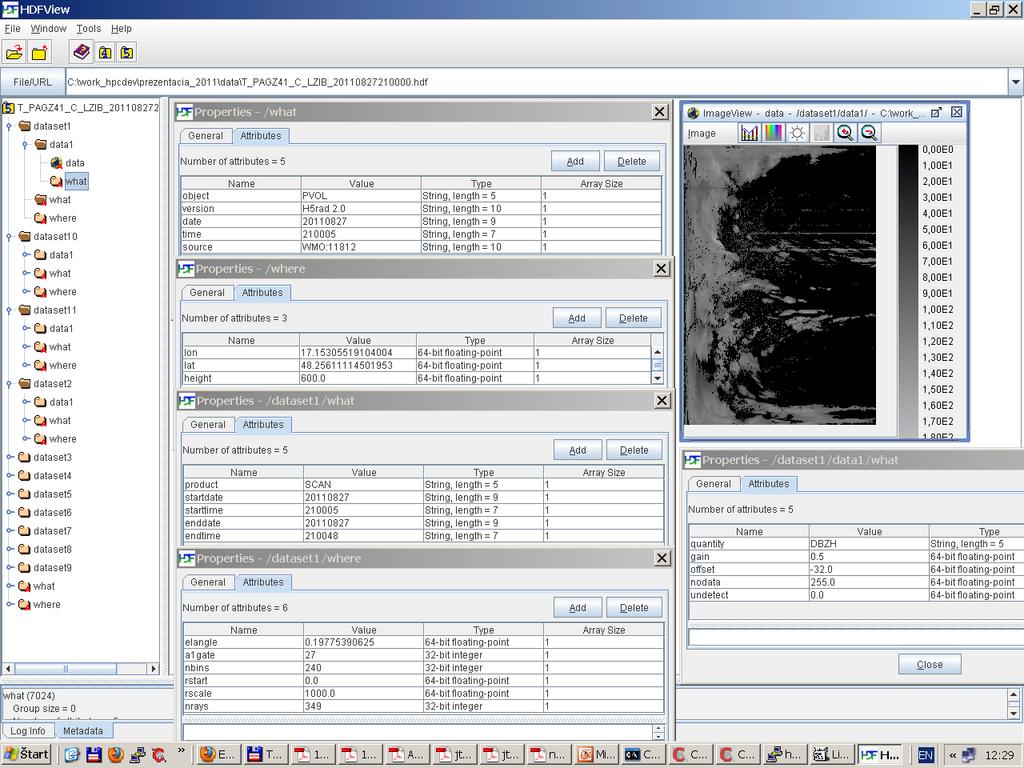
1 Radar and SAFNWC data APIs in SHMI Ladislav Méri Ľuboslav Okon SHMI, Bratislava, Slovakia 6 7 February, 2012 (API = Application Programming Interface)
2 Why radar volumes and SAFNWC? Goals: Improve the quantitative precipitation estimation Improve the precipitation nowcasting Our solution: Transition from 2D to 3D Quality index based precipitation analysis Actual input data: text files with a 2D composite of some standard radar product (CAPPI 2km, BASE, ) New input data: volume data from several radars in ODIM_H5 format (OPERA Data Information Model for HDF5) and SAFNWC products (mainly in HDF5) Advantages: flexibility (selection of required radars, interpolation and compositing) product generation (CAPPI, CMAX, BASE, ECHOTOP, VIL, ) quality control (quality indexes, data check and filtering)
3 ODIM H5
4 Module my_hdf5 /*this module uses the hdf5 api functions (H5Fopen, H5Gopen, H5Dread, )*/ int read_double_attribute( hid_t Where, char *Name, double *Value ); int read_float_attribute( hid_t Where, char *Name, float *Value ); int read_int_attribute( hid_t Where, char *Name, int *Value ); int read_string_attribute( hid_t Where, char *Name, char *Value ); char *read_2d_char_data( hid_t Where, char *Name, int *DataSize ); unsigned short *read_2d_ushort_data( hid_t Where, char *Name, int *DataSize ); Example: /*open the file*/ Hid_t FileID, GrID; FileID = H5Fopen("/opera/ /cz/T_PAGZ50_C_OKPR_ hdf", H5F_ACC_RDONLY, H5P_DEFAULT ); if ( FileID < 0 ) { return -1; } /*open the /where group*/ GrID = H5Gopen( FileID, /where, H5P_DEFAULT ); if ( GrID < 0 ) { return -1; } /*read some parameters*/ Double Lat, Lon; int err; err = read_double_attribute( GrID, "lat", &Lat ); err = read_double_attribute( GrID, "lon", &Lon ); printf( Radar Lat: %f, Lon %f\n, Lat, Lon);
5 Radar volume data structure Volume 1 Volume 2 Volume N Scan 1 Scan 2 Scan M Moment 1 Moment 2 Moment K
6 Module radar moment typedef struct radar_moment { char Quantity[32]; /* moment name (TH, DBZH, VRAD, ) */ int RayNumber; /* number of rays */ int BinNumber; /* number of bins */ double Gain; /* bin_value = Gain*BScope[i][j] + Offset */ double Offset; unsigned char NoData; /* value for never radiated area */ unsigned char Undetect; /* radiated, but nothing detected */ unsigned char *BScope; /* array of the meassured data in b-scope mode */ } RADAR_MOMENT; int radar_moment_init( RADAR_MOMENT *Mom, char *Quantity, int RayNumber, int BinNumber, double Gain, double Offset, unsigned char NoData, unsigned char Undetect ); int radar_moment_deinit( RADAR_MOMENT *Mom ); int radar_moment_set_bin_char( RADAR_MOMENT *Mom, int RayI, int BinI, unsigned char BinVal ); int radar_moment_set_bin_doub( RADAR_MOMENT *Mom, int RayI, int BinI, double BinVal ); int radar_moment_get_bin_doub( RADAR_MOMENT *Mom, int RayI, int BinI, double *BinVal ); int radar_moment_copy( RADAR_MOMENT *MomIn, RADAR_MOMENT *MomOut );
7 Module radar scan typedef struct radar_scan { char StartDate[9]; /* starting YYYYMMDD */ char StartTime[7]; /* starting hhmmss */ char EndDate[9]; /* ending YYYYMMDD */ char EndTime[7]; /* ending hhmmss */ double ElAngle; /* antenna elevation angle (degrees) above the horizon */ double RStart; /* the range (km) of the start of the first range bin */ double RScale; /* the distance in meters between two successive range bins */ int NRays; /* number of azimuth gates (rays) in the scan */ int NBins; /* number of range bins in each ray */ int A1Gate; /* index of the first azimuth gate radiated in the scan (1-NRays)*/ int MomentNumber; /* number of moments */ RADAR_MOMENT *Moments; /* list of moments in the scan */ } RADAR_SCAN; int radar_scan_init( RADAR_SCAN *Scan, char *StartDate, char *StartTime, char *EndDate, char *EndTime, double ElAngle, double RStart, double RScale, int NRays, int NBins, int A1Gate ); int radar_scan_add_moment( RADAR_SCAN *Scan, RADAR_MOMENT *Mom ); int radar_scan_rayindex2azi( RADAR_SCAN *Scan, int index, double *Azi ); int radar_scan_azi2rayindexpair( RADAR_SCAN *Scan, double Azi, int *IndexPair ); int radar_scan_get_bin_value_by_moment_index( RADAR_SCAN *Scan, int MomentI, int RayI, int BinI, double *BinVal ); int radar_scan_get_bin_value_by_moment_quantity( RADAR_SCAN *Scan, char *Qua, int RayI, int BinI, double *BinVal );
8 Module radar volume typedef struct radar_volume { char Date[9]; /* Nominal Year, Month, and Day of the data (YYYYMMDD) */ char Time[7]; /* Nominal Hour, Minute, and Second, in UTC of the data (hhmmss) */ char Source[128]; /* Radar site indetifier */ double Lat; /* Latitude position of the radar antenna (degrees) */ double Lon; /* Longitude position of the radar antenna (degrees) */ double Height; /* Height of the centre of the antenna in meters above sea level */ double Beamwidth; /* The radar s half-power beamwidth (degrees) */ int ScanNumber; /* Number of elevation scans */ RADAR_SCAN *Scans; /* List of scans in the volume */ } RADAR_VOLUME; int radar_volume_add_scan( RADAR_VOLUME *Vol, RADAR_SCAN *Scan ); int radar_volume_add_moment( RADAR_VOLUME *Vol, RADAR_MOMENT *Mom, int ScanIndex ); int radar_volume_azi2rayindexpair( RADAR_VOLUME *Vol, int ScanIndex, double Azi, int *IndexPair ); int radar_volume_binindex2range( RADAR_VOLUME *Vol, int ScanIndex, int BinIndex, double *Range ); int radar_volume_scanindex2elev( RADAR_VOLUME *Vol, int i, double *Val ); int radar_volume_elev2scanindexes( RADAR_VOLUME *Vol, double ElAngle, int *IndexNum, int *IndexList ); int radar_volume_get_bin_value_by_moment_index( RADAR_VOLUME *Vol, int ScanI, int MomI, int RayI, int BinI, double *BinVal ); int radar_volume_get_bin_value_by_moment_quantity( RADAR_VOLUME *Vol, int ScanI, char *Qua, int RayI, int BinI, double *BinVal );
9 Reading radar volume from an ODIM_H5 file module_myhdf5 + module_radar_volume = module_radar_volume_io: int radar_moment_read_by_index_from_odimh5( RADAR_MOMENT *Mom, char *FileName, int ScanIndex, int MomentIndex ); int radar_scan_read_by_index_from_odimh5( RADAR_SCAN *Scan, char *FileName, int ScanIndex ); int radar_volume_read_from_odimh5( RADAR_VOLUME *Vol, char *FileName ); example: RADAR_VOLUME Vol; int err; err = radar_volume_read_from_odimh5( &Vol, "/opera/ /cz/t_pagz50_c_okpr_ hdf" ); if ( err!= 0 ) { return -1; } printf( radar latitude: %f, radar longitude: %f \n", Vol1Lon, Vol1Lat); int scani = 1, momi = 1, rayi = 183, bini = 135; double d; err = radar_volume_get_bin_value_by_moment_index( &Vol, scani, momi, rayi, bini, &d ); printf( The bin %d in scan %d, moment %d, ray %d has a value of %f\n, bini, scani, momi, rayi, d);

10 SAFNWC hdf5
11 Module map array typedef struct map_array { int nx; /*number of points in x direction*/ int ny; /*number of points in y direction*/ int nz; /*number of points in z direction*/ int IsInit; double *Data; /*poi to the data array*/ } MAP_ARRAY; int map_array_init( MAP_ARRAY *MA, int nx, int ny, int nz, double IniVal ); int map_array_deinit( MAP_ARRAY *MA ); int map_array_get_value( MAP_ARRAY *MA, int x, int y, int z, double *Val ); int map_array_set_value( MAP_ARRAY *MA, int x, int y, int z, double Val );
12 Module geos map typedef struct geos_map { int Nx; /*number of columns (pixels in x direction)*/ int Ny; /*number of lines (pixels in y direction)*/ double SubLon; /*sub-satellite longitude in degrees*/ double coff; /*column offset*/ double cfac; /*column scale factor (c = coff + x*cfac*(2^-16)), c(1-nx)*/ double loff; /*line offset*/ double lfac; /*line scale factor (l = lf + y*lfac*(2^-16)), l(1-ny)*/ double cfac2; /*cfac*(2^-16)*/ double lfac2; /*lfac*(2^-16)*/ MAP_ARRAY Map; /*map array*/ } GEOS_MAP; int geos_map_init( GEOS_MAP *GMap, int Nx, int Ny, double SubLon, double coff, double cfac, double loff, double lfac, double IniVal ); int geos_map_deinit( GEOS_MAP *GMap ); int geos_map_lonlat2xy( GEOS_MAP *GMap, double lon, double lat, int *x, int *y ); int geos_map_xy2lonlat( GEOS_MAP *GMap, int x, int y, double *lon, double *lat ); int geos_map_set_value_by_index( GEOS_MAP *GMap, int x, int y, double Val ); int geos_map_get_value_by_index( GEOS_MAP *GMap, int x, int y, double *Val ); int geos_map_set_value_by_coord( GEOS_MAP *GMap, double lon, double lat, double Val ); int geos_map_get_value_by_coord( GEOS_MAP *GMap, double lon, double lat, double *Val );
13 Reading SAFNWC products module_my_hdf5 + module_geos_map = module_geos_map_io: int geos_map_read_from_safnwch5( GEOS_MAP *GMap, char *H5FileName, char *ProductName, int ByteSize ); Example: GEOS_MAP CTMap; int err; err = geos_map_read_from_safnwch5( &CTMap, "SAFNWC_MSG2_CT _slovakia h5", "CT", 1 ); printf("ct read: %d\n", err); double d; int x = 100, y = 100; err = geos_map_get_value_by_index(&ctmap, x, y, &d ); printf( The Cloud Type value in column %d and line %d is %f\n, x, y, d); err = geos_map_get_value_by_coord(&ctmap, , 48255, &d ); printf( The Cloud Type value in point (Lon = , Lat = 48255) is %f\n, d);
14 Radar bin coordinates typedef struct radar_bin_coord { int ScanNumber; int RayNumber; int BinNumber; float *LonTable; float *LatTable; float *HeiTable; RADAR_VOLUME *Rad; } RADAR_BIN_COORD; int radar_bin_coord_init( RADAR_BIN_COORD *RbcTable, RADAR_VOLUME *Vol ); int radar_bin_coord_compute_from_eq_earth( RADAR_BIN_COORD *RbcTable, RADAR_VOLUME *Vol ); int radar_bin_coord_compute_from_beam_prop_model( RADAR_BIN_COORD *RbcTable, RADAR_VOLUME *Vol, LAMBERT_MAP *n_grad ); int radar_bin_coord_get_closest_bin_indexes( RADAR_BIN_COORD *RbcTable, double Plon, double Plat, double Phei, INT_LIST *ScanIndexList, INT_LIST *RayIndexList, INT_LIST *BinIndexList );
15 Radar Quality Check Quality Index (value from 00 to 10, 1=good quality, 0=bad quality) computing for every bin: int single_radar_qi_set_laplace_for_volume( RADAR_VOLUME *Vol, char *MomName, char *QIName, double MinTH, double MaxTH ); int single_radar_qi_set_rlan_for_volume( RADAR_VOLUME *Vol, char *MomName, char *QIName, double StartTH, double AmpTH, int MaxWidth ); int single_radar_qi_set_atten_for_volume( RADAR_VOLUME *Vol, char *MomName, char *QIName, double a, double b, double MaxF, char *QIFilt1Name, double QIFilt1Thr, char *QIFilt2Name, double QIFilt2Thr ); int single_radar_qi_set_safnwc_for_volume( RADAR_VOLUME *Vol, char *MomName, RADAR_BIN_COORD *RadBinCo, GEOS_MAP *CTMap, GEOS_MAP *CTHMap, GEOS_MAP *PCMap, char *QIName );


16 Radar Quality Check - Example Radar Maly Javornik reflectivity filtered QI RLAN Laplace SAFNWC All
17 Module inca_proj_map typedef struct inca_proj_map { double x0; /*x for SW corner from subroutine KEKO (see file inca_projf)*/ double y0; /*y for SW corner from subroutine KEKO (see file inca_projf)*/ double z0; /*height for the lowest level in [m] ASL*/ double dx; /*step in x direction (x = x0 + (i-1)*dx -> for i = 1,,nx)*/ double dy; /*step in y direction (y = y0 + (j-1)*dy -> for j = 1,,ny)*/ double dz; /*step in vertical dir in [m]*/ int nx; /*point number in x direction*/ int ny; /*point number in y direction*/ int nz; /*nuber of verical levels*/ MAP_ARRAY Map; /*map array*/ } INCA_PROJ_MAP; int inca_proj_map_init( INCA_PROJ_MAP *IPMap, double x0, double y0, double z0, double dx, double dy, double dz, int nx, int ny, int nz, double IniVal ); int inca_proj_map_lonlatheight2xyz( INCA_PROJ_MAP *IPMap, double Lon, double Lat, double Hei, int *x, int *y, int *z ); int inca_proj_map_xyz2lonlatheight( INCA_PROJ_MAP *IPMap, int x, int y, int z, double *Lon, double *Lat, double *Hei ); int inca_proj_map_set_value_by_index( INCA_PROJ_MAP *IPMap, int x, int y, int z, double Val ); int inca_proj_map_get_value_by_coord( INCA_PROJ_MAP *IPMap, double Lon, double Lat, double Hei, double *Val );
18 Example with radar volume /*read the radar volume from a hdf5 file*/ RADAR_VOLUME Vol; int err; err = radar_volume_read_from_odimh5( &Vol, "/opera/ /cz/t_pagz50_c_okpr_ hdf" ); /*set some quality indexes*/ err = single_radar_qi_set_rlan_for_volume( &Vol1, "DBZH", "QI_RLAN", 40, 80, 80 ); err = single_radar_qi_set_laplace_for_volume( &Vol1, "DBZH", "QI_LAPL", 500, 1500 ); err = single_radar_qi_set_atten_for_volume( &Vol1, "DBZH", "QI_ATTEN", 2000, 16, 30, "QI_RLAN", 05, "QI_LAPL", 05 ); /*init and set the radar bin coordinate table*/ RADAR_BIN_COORD RadBinCo; err = radar_bin_coord_init( &RadBinCo, &Vol1 ); err = radar_bin_coord_compute_from_eq_earth( &RadBinCo, &Vol1 ); /*init the output INCA maps*/ INCA_PROJ_MAP DbzhMap, QiMap; err = inca_proj_map_init( &DbzhMap, 6000, 4000, 10000, 10, 10, 10000, 501, 301, 9, 955 ); err = inca_proj_map_init( &QiMap, 6000, 4000, 10000, 10, 10, 10000, 501, 301, 9, 00 ); /*put the radar volume in to the maps*/ err = opera2inca_vol2map3d( &Vol1, &RadBinCo, , "DBZH", &DbzhMap, &QiMap ); /*read some data from the map*/ int x = 100, y = 120, z = 2; err = inca_proj_map_get_value_by_index( &DbzhMap, x, y, z, &d ); printf( DBZH value in point %d %d %d is %f\n, x, y, z, d);

19 3D radar map example
20 Future plans Implement other quality indexes for radar measurement (beam blockage, ) Compute quality indexes of rainfall estimation from the radar data (height of the level used for estimate the rainfall, accuracy of Marshall-Palmer parameters, possible bright band, uncertainties in the phase of the rainfall (snow, liquid, hail, mixed)) Compute quality indexes also for rain gauges data Combine all the measurements (rain gauge, radar, SAFNWC, HSAF, ) to get the best estimation of the rainfall rate Thank You! ladislavmeri@shmusk, luboslavokon@shmusk
Definition of Basic Polar Data Product
 Definition of Basic Polar Data Product OPERA project 1d3: working document WD 02 03 Iwan Holleman and Gianmario Galli Date: September 22, 2003 1 1 Introduction During the OPERA project an additional deliverable
Rack a program for anomaly detection, product generation, and compositing
 Rack a program for anomaly detection, product generation, and compositing Markus Peura Finnish Meteorological Institute, Helsinki, Finland (first.last@fmi.fi) (Dated: May 30, 2012 ) 1 Introduction Rack
SPOT VGT.
 SPOT VGT http://www.spot-vegetation.com/ SPOT VGT General Information Resolution: 1km Projection: Unprojected, Plate Carree Geodetic system: WGS 1984 Geographic Extent Latitude: 75 o N to 56 o S Longitude:
GLOBAL PRECIPITATION MEASUREMENT PRECIPITATION PROCESSING SYSTEM. File Specification AMSUBBASE. Preliminary Version
 GLOBAL PRECIPITATION MEASUREMENT PRECIPITATION PROCESSING SYSTEM File Specification AMSUBBASE Preliminary Version October 12, 2015 0.1 AMSUBBASE - AMSUB base AMSUBBASE contains brightness temperature from
MDV FORMAT Interface Control Document (ICD)
") Overview MDV FORMAT Interface Control Document (ICD) Mike Dixon Research Applications Laboratory (RAL) National Center for Atmospheric Research (NCAR) Boulder, Colorado, USA Overview MDV history The Meteorological
Overview MDV FORMAT Interface Control Document (ICD) Mike Dixon Research Applications Laboratory (RAL) National Center for Atmospheric Research (NCAR) Boulder, Colorado, USA Overview MDV history The Meteorological
GOME NO 2 data product HDF data file user manual
 GOME NO 2 data product HDF data file user manual Folkert Boersma and Henk Eskes 23 April 2002 Contents Content of the no2trackyyyymmdd.hdf files 3 The use of the averaging kernel 6 IDL sample code to read
Revision History. Applicable Documents
 Revision History Version Date Revision History Remarks 1.0 2011.11-1.1 2013.1 Update of the processing algorithm of CAI Level 3 NDVI, which yields the NDVI product Ver. 01.00. The major updates of this
Assimilated SCIAMACHY NO 2 fields HDF data file user manual
 Assimilated SCIAMACHY NO 2 fields HDF data file user manual Folkert Boersma and Henk Eskes 6 February 2004 1 Contents Content of the no2trackyyyymmdd.hdf files 3 The use of the averaging kernel 6 IDL sample
Beginner s Guide to VIIRS Imagery Data. Curtis Seaman CIRA/Colorado State University 10/29/2013
 Beginner s Guide to VIIRS Imagery Data Curtis Seaman CIRA/Colorado State University 10/29/2013 1 VIIRS Intro VIIRS: Visible Infrared Imaging Radiometer Suite 5 High resolution Imagery channels (I-bands)
MODIS Atmosphere: MOD35_L2: Format & Content
 Page 1 of 9 File Format Basics MOD35_L2 product files are stored in Hierarchical Data Format (HDF). HDF is a multi-object file format for sharing scientific data in multi-platform distributed environments.
Level 2C RAIN-PROFILE Product Process Description and Interface Control Document Algorithm version 0.0
 CloudSat Project A NASA Earth System Science Pathfinder Mission Level 2C RAIN-PROFILE Product Process Description and Interface Control Document Algorithm version 0.0 Date: 20 June 2011 Address questions
OPERA BUFR guidelines
 OPERA BUFR guidelines Bernard Urban Meteo France (DSO/CMR) September 25, 2008 1 Introduction BUFR is a very flexible way of transmitting and archiving meteorological information. This flexibility, added
Level 2 Radar-Lidar GEOPROF Product VERSION 1.0 Process Description and Interface Control Document
 Recommendation JPL Document No. D-xxxx CloudSat Project A NASA Earth System Science Pathfinder Mission Level 2 Radar-Lidar GEOPROF Product VERSION 1.0 Process Description and Interface Control Document
Distributed rainfall runoff model: 1K DHM event. Demonstration and Project
 CE74.55 Modeling of Water Resources Systems February 26 th and 27 th, 2011 Distributed rainfall runoff model: 1K DHM event Demonstration and Project Yasuto TACHIKAWA Dept. of Civil and Earth Resources
Files Used in this Tutorial
 Generate Point Clouds and DSM Tutorial This tutorial shows how to generate point clouds and a digital surface model (DSM) from IKONOS satellite stereo imagery. You will view the resulting point clouds
EROS Metadata specifications. March 07, ImageSat International, N.V. Version 3
 Page 1 out of 23 EROS Metadata specifications March 07, 2010 ImageSat International, N.V. Version 3 Page 2 out of 23 Changes from Version 1, October 19, 2006 # Date Change (1) Jan 30, 2008 Addition of
Hierarchical Data Format 5:
 Hierarchical Data Format 5: Giusy Muscianisi g.muscianisi@cineca.it SuperComputing Applications and Innovation Department May 17th, 2013 Outline What is HDF5? Overview to HDF5 Data Model and File Structure
Compact VIIRS SDR Product Format User Guide
 Compact VIIRS SDR Product Format User Guide Doc.No. : EUM/TSS/DOC/13/708025 Issue : v1c Date : 21 August 2014 WBS : EUMETSAT Eumetsat-Allee 1, D-64295 Darmstadt, Germany Tel: +49 6151 807-7 Fax: +49 6151
AATSR LEVEL 2 DETAILED PROCESSING MODEL & PARAMETER DATA LIST
 AATSR Expert Support Laboratory Page 1 of 141 AATSR LEVEL 2 DETAILED PROCESSING MODEL & PARAMETER DATA LIST SCIENCE AND TECHNOLOGY FACILITIES COUNCIL RUTHERFORD APPLETON LABORATORY Chilton, Didcot Oxfordshire
SGLI Level-2 data Mati Kahru
 SGLI Level-2 data Mati Kahru 2018 1 Working with SGLI Level-2 data Contents Working with SGLI Level-2 data... 1 1 Introduction... 1 2 Evaluating SGLI Level-2 data... 1 3 Finding match-ups in SGLI Level-2
XYZ Exporter Page 1. XYZ Exporter
 XYZ Exporter Page 1 XYZ Exporter XYZ Exporter Page 2 1. Introduction This program was created to takeover from NaviScan Convert. It has the capability to export to various formats, where you have the possibility
Application of ray-tracing through the high resolution numerical weather model HIRLAM for the analysis of European VLBI data
 Application of ray-tracing through the high resolution numerical weather model HIRLAM for the analysis of European VLBI data Susana Garcia-Espada(1,2) Rüdiger Haas(2) Francisco Colomer(1) (1) Instituto
Sentinel-1 Toolbox. Offset Tracking Tutorial Issued August Jun Lu Luis Veci
 Sentinel-1 Toolbox Offset Tracking Tutorial Issued August 2016 Jun Lu Luis Veci Copyright 2016 Array Systems Computing Inc. http://www.array.ca/ http://step.esa.int Offset Tracking Tutorial The goal of
grib_api.h File Reference
 grib_api.h File Reference Copyright 2005-2013 ECMWF. More... Defines #define GRIB_API_VERSION (GRIB_API_MAJOR_VERSION*10000+G RIB_API_MINOR_VERSION*100+GRIB_API_REVISION_VERSI ON) #define GRIB_SECTION_PRODUCT
The Study and Implementation of Extraction HY-1B Level 1B Product Image Data Based on HDF Format Shibin Liu a, Wei Liu ab, Hailong Peng c
 The Study and Implementation of Extraction HY-1B Level 1B Product Image Data Based on HDF Format Shibin Liu a, Wei Liu ab, Hailong Peng c a Center for Earth Observation and Digital Earth, Chinese Academy
NAME alloc_l1 allocate memory for level-1 record. SYNOPSIS int alloc_l1 (int npix, l1str *l1rec); ARGUMENTS number of pixels level-1 data record
; ARGUMENTS number of pixels level-1 data record") alloc_l1(3) aps_seawifs API Reference alloc_l1(3) alloc_l1 allocate memory for level-1 record int alloc_l1 (int npix, l1str *l1rec); npix l1rec number of pixels level-1 data record allocates 1 level-1b
alloc_l1(3) aps_seawifs API Reference alloc_l1(3) alloc_l1 allocate memory for level-1 record int alloc_l1 (int npix, l1str *l1rec); npix l1rec number of pixels level-1 data record allocates 1 level-1b
NIES GOSAT TANSO-CAI Level 3 Data Product Format Description
 NIESOSATPO00633 NIES OSAT TANSOCAI Level 3 Data Product Format Description Version 3.00 National Institute for Environmental Studies OSAT Project November 30, 206 Revision history Version Revised on Page
NIES GOSAT TANSO-CAI Level 3 Data Product Format Description
 NIESOSATPO00633 NIES OSAT TANSOCAI Level 3 Data Product Format Description Version 2.00 National Institute for Environmental Studies OSAT Project Office September 28, 202 Revision history Version Revised
Community radar data analysis in Python wradlib: an open source weather radar library. Maik Heistermann and Kai Muehlbauer
 Community radar data analysis in Python wradlib: an open source weather radar library Maik Heistermann and Kai Muehlbauer Potsdam and Bonn Last update: May 2015 In brief wradlib is a Python package started
A MapReduce Technique to Mosaic Continental-Scale Weather Radar Data in Real-time
 IEEE JOURNAL OF SELECT TOPICS IN APPLIED EARTH OBSERVATIONS AND REMOTE SENSING 1 A MapReduce Technique to Mosaic Continental-Scale Weather Radar Data in Real-time Valliappa Lakshmanan 1,2, Timothy W. Humphrey
Graphics Overview ECE2893. Lecture 19. ECE2893 Graphics Overview Spring / 15
 Graphics Overview ECE2893 Lecture 19 ECE2893 Graphics Overview Spring 2011 1 / 15 Graphical Displays 1 Virtually all modern computers use a full color Graphical Display device. 2 It displays images, text,
First TOPSAR image and interferometry results with TerraSAR-X
 First TOPSAR image and interferometry results with TerraSAR-X A. Meta, P. Prats, U. Steinbrecher, R. Scheiber, J. Mittermayer DLR Folie 1 A. Meta - 29.11.2007 Introduction Outline TOPSAR acquisition mode
Worksheet 4 Basic Input functions and Mathematical Operators
 Name: Student ID: Date: Worksheet 4 Basic Input functions and Mathematical Operators Objectives After completing this worksheet, you should be able to Use an input function in C Declare variables with
Geographic Information Systems (GIS) Spatial Analyst [10] Dr. Mohammad N. Almasri. [10] Spring 2018 GIS Dr. Mohammad N. Almasri Spatial Analyst
![Geographic Information Systems (GIS) Spatial Analyst [10] Dr. Mohammad N. Almasri. [10] Spring 2018 GIS Dr. Mohammad N. Almasri Spatial Analyst](/thumbs/80/81171101.jpg "Geographic Information Systems (GIS) Spatial Analyst [10] Dr. Mohammad N. Almasri. [10] Spring 2018 GIS Dr. Mohammad N. Almasri Spatial Analyst") Geographic Information Systems (GIS) Spatial Analyst [10] Dr. Mohammad N. Almasri 1 Preface POINTS, LINES, and POLYGONS are good at representing geographic objects with distinct shapes They are less good
Geographic Information Systems (GIS) Spatial Analyst [10] Dr. Mohammad N. Almasri 1 Preface POINTS, LINES, and POLYGONS are good at representing geographic objects with distinct shapes They are less good
STSM Report: Algorithm operationalisation in BALTRAD: upgrade and back processing
 STSM Report: Algorithm operationalisation in BALTRAD: upgrade and back processing Liesbeth Verlinden 9-13 January 2017 Abstract This report gives an overview of my STSM at the Swedish Meteorological and
EUMETNET OPERA PROGRAMME. Subproject 1e/1. Definition of Software Library Content
 EUMETNET OPERA PROGRAMME Subproject 1e/1 Marcelino Manso OPERA/WD/6/2002 Final document September 2003 OPERA/WD/6/2002 2 1.- Introduction Within Work Area 1, Production of Radar Data, the objective of
L7 Raster Algorithms
 L7 Raster Algorithms NGEN6(TEK23) Algorithms in Geographical Information Systems by: Abdulghani Hasan, updated Nov 216 by Per-Ola Olsson Background Store and analyze the geographic information: Raster
GSMaP Product Format. Version 2.0
 GSMaP Product Format Version 2.0 January 17 th, 2017 Japan Aerospace Exploration Agency Revision history revision date section content, reason Version 1.0 Sept. 2 nd 2014 ALL New Version 2.0 Jan. 17 th
Study of the Effects of Target Geometry on Synthetic Aperture Radar Images using Simulation Studies
 Study of the Effects of Target Geometry on Synthetic Aperture Radar Images using Simulation Studies K. Tummala a,*, A. K. Jha a, S. Kumar b a Geoinformatics Dept., Indian Institute of Remote Sensing, Dehradun,
Overview Trajectory Details
 Overview The new trajectory code tracks three dimensional variables, with an XZY ordering, from a specified starting point along a lagrangian trajectory. Along any trajectory there may be up to 100 defined
Generate Glacier Velocity Maps with the Sentinel-1 Toolbox
 Making remote-sensing data accessible since 1991 Generate Glacier Velocity Maps with the Sentinel-1 Toolbox Adapted from the European Space Agency s STEP community platform In this document you will find:
IMS4 AMS 111 II M. Automatic Mobile Weather Station for military usage AMS 111 II M
 IMS4 Automatic Mobile Weather Station for military usage FEATURES: Military class equipment Military design optional Aviation weather observation Climatological observation Synoptic observation Radiation
CCPLOT(1) BSD General Commands Manual CCPLOT(1)
 BSD General Commands Manual CCPLOT(1)") NAME ccplot CloudSat and CALIPSO data plotting tool SYNOPSIS ccplot [ a ratio] [ c cmapfile] [ d dpi] [ m band] [ o outfile] [ p projection[:projoptions]] [ r radius] [ v] [ x extent] [ y extent] [ z options]
NAME ccplot CloudSat and CALIPSO data plotting tool SYNOPSIS ccplot [ a ratio] [ c cmapfile] [ d dpi] [ m band] [ o outfile] [ p projection[:projoptions]] [ r radius] [ v] [ x extent] [ y extent] [ z options]
L1AVNE (Visible and Near Infrared), L1ATIE (Thermal Infrared)
, L1ATIE (Thermal Infrared)") 2.0 LEVEL 1A DATA 2.1 Introduction OCTS Level 1A products are classified into three products following with data acquisition and processing method; GAC(Global Area Coverage), LAC (Local Area Coverage),
2.0 LEVEL 1A DATA 2.1 Introduction OCTS Level 1A products are classified into three products following with data acquisition and processing method; GAC(Global Area Coverage), LAC (Local Area Coverage),
High Performance Radar Signal Processsing
 High Performance Radar Signal Processsing First Semester Report Fall 2012 by Justin Haze Prepared to partially fulfill the requirements for ECE401 Department of Electrical and Computer Engineering Colorado
SDK User Guide. DFS file system, PFS file system
 SDK User Guide DFS file system, PFS file system MIKE 2017 DHI headquarters Agern Allé 5 DK-2970 Hørsholm Denmark +45 4516 9200 Telephone +45 4516 9333 Support +45 4516 9292 Telefax mike@dhigroup.com www.mikepoweredbydhi.com
Preprocessed Input Data. Description MODIS
 Preprocessed Input Data Description MODIS The Moderate Resolution Imaging Spectroradiometer (MODIS) Surface Reflectance products provide an estimate of the surface spectral reflectance as it would be measured
Data Mining Storm Attributes
 Data Mining Storm Attributes VA L L I A P PA L A K S H M A N A N N AT I O N A L S E V E R E S T O R M S L A B O R AT O R Y / U N I V E R S I T Y O F O K L A H O M A L A K S H M A N @ O U. E D U AT C I
ROTCTL(1) Rotator Control Program ROTCTL(1)
 Rotator Control Program ROTCTL(1)") NAME rotctl control antenna rotators SYNOPSIS rotctl [OPTION]... [COMMAND]... DESCRIPTION Control antenna rotators. rotctl accepts commands from the command line as well as in interactive mode if none
NAME rotctl control antenna rotators SYNOPSIS rotctl [OPTION]... [COMMAND]... DESCRIPTION Control antenna rotators. rotctl accepts commands from the command line as well as in interactive mode if none
InSAR Operational and Processing Steps for DEM Generation
 InSAR Operational and Processing Steps for DEM Generation By F. I. Okeke Department of Geoinformatics and Surveying, University of Nigeria, Enugu Campus Tel: 2-80-5627286 Email:francisokeke@yahoo.com Promoting
Principles of the Global Positioning System Lecture 15" Propagation Medium: Neutral atmosphere" Basic atmospheric structure"
 12.540 Principles of the Global Positioning System Lecture 15" Prof. Thomas Herring" Room 54-820A; 253-5941" tah@mit.edu" http://geoweb.mit.edu/~tah/12.540 " Propagation Medium: Neutral atmosphere" Summary"
14.9: Real-time Merging of Multisource Data
 14.9: Real-time Merging of Multisource Data V Lakshmanan National Severe Storms Laboratory & University of Oklahoma Abstract We describe an extension of the virtual volume concept to multiple sensors.
Ice Cover and Sea and Lake Ice Concentration with GOES-R ABI
 GOES-R AWG Cryosphere Team Ice Cover and Sea and Lake Ice Concentration with GOES-R ABI Presented by Yinghui Liu 1 Team Members: Yinghui Liu 1, Jeffrey R Key 2, and Xuanji Wang 1 1 UW-Madison CIMSS 2 NOAA/NESDIS/STAR
Scene Modeling from Motion-Free Radar Sensing
 Scene Modeling from Motion-Free Radar Sensing Alex Foessel Robotics Institute Carnegie Mellon University Ph.D. Thesis Proposal May 13, 1999 Motivation - 2 - Presentation I. Research on Radar for Robots
Chapters 1 9: Overview
 Chapters 1 9: Overview Chapter 1: Introduction Chapters 2 4: Data acquisition Chapters 5 9: Data manipulation Chapter 5: Vertical imagery Chapter 6: Image coordinate measurements and refinements Chapters
Metview FLEXTRA Tutorial. Meteorological Visualisation Section Operations Department ECMWF
 Meteorological Visualisation Section Operations Department ECMWF 05/03/2015 This tutorial was tested with Metview version 4.3.0 and will not work for previous versions. Copyright 2015 European Centre for
Geographic Information Systems. using QGIS
 Geographic Information Systems using QGIS 1 - INTRODUCTION Generalities A GIS (Geographic Information System) consists of: -Computer hardware -Computer software - Digital Data Generalities GIS softwares
RADAN 7 Release Notes
 RADAN 7 Release Notes Release 7.4.16.12090 Please see RADAN7-SystemRequirements.pdf if you are considering upgrading to RADAN 7 from earlier versions of RADAN or if you want to review the system requirements.
Recognition and Measurement of Small Defects in ICT Testing
 19 th World Conference on Non-Destructive Testing 2016 Recognition and Measurement of Small Defects in ICT Testing Guo ZHIMIN, Ni PEIJUN, Zhang WEIGUO, Qi ZICHENG Inner Mongolia Metallic Materials Research
AMSR IDL (read_amsr_day_v5.pro): .pro. : PRO example (means this script starts here and it s name is example.pro)
: .pro. : PRO example (means this script starts here and it s name is example.pro)") IDL 2007/1/17~18, C202 - REMSS (free, ) http//wwwremsscom AMSR IDL (read_amsr_day_v5pro) HomePage -> AMSR -> Download Data (via ftpssmicom/amsre) -> FTP server -> support/idl/read_amsr_day_v5pro AMSR HomePage
IDL 2007/1/17~18, C202 - REMSS (free, ) http//wwwremsscom AMSR IDL (read_amsr_day_v5pro) HomePage -> AMSR -> Download Data (via ftpssmicom/amsre) -> FTP server -> support/idl/read_amsr_day_v5pro AMSR HomePage
2 Assembling a consistent time series of sea ice data
 Detection of Change in the Arctic Mati Kahru 2012 1 Detection of Change in Arctic Sea-Ice Contents Detection of Change in the Arctic, Ice... 1 1 Introduction... 1 2 Assembling a consistent time series
GEOG 4110/5100 Advanced Remote Sensing Lecture 4
 GEOG 4110/5100 Advanced Remote Sensing Lecture 4 Geometric Distortion Relevant Reading: Richards, Sections 2.11-2.17 Geometric Distortion Geometric Distortion: Errors in image geometry, (location, dimensions,
COMS W3101 Programming Language: C++ (Fall 2015) Ramana Isukapalli
 Ramana Isukapalli") COMS W3101 Programming Language: C++ (Fall 2015) ramana@cs.columbia.edu Lecture-2 Overview of C continued C character arrays Functions Structures Pointers C++ string class C++ Design, difference with C
COMS W3101 Programming Language: C++ (Fall 2015) ramana@cs.columbia.edu Lecture-2 Overview of C continued C character arrays Functions Structures Pointers C++ string class C++ Design, difference with C
Tilt program user guide
 Tilt program user guide Purpose Tilt program calculates tilt of ionosphere at the specific observation point and time. One of the main features of this program is that it can calculate real time tilt of
PSK Propagation Reporter DLL Documentation 2013-Mar-10 Philip Gladstone
 PSK Propagation Reporter DLL Documentation 2013-Mar-10 Philip Gladstone This describes the PSK Propagation Reporter API that is available on Windows and which is provided by
Tropical Rainfall Measuring Mission (TRMM) Precipitation Radar Algorithm. Instruction Manual For Version 7
 Precipitation Radar Algorithm. Instruction Manual For Version 7") Tropical Rainfall Measuring Mission (TRMM) Precipitation Radar Algorithm Instruction Manual For Version 7 TRMM Precipitation Radar Team Japan Aerospace Exploration Agency (JAXA) National Aeronautics and
Tropical Rainfall Measuring Mission (TRMM) Precipitation Radar Algorithm Instruction Manual For Version 7 TRMM Precipitation Radar Team Japan Aerospace Exploration Agency (JAXA) National Aeronautics and
Practice problems Set 2
 Practice problems Set 2 1) Write a program to obtain transpose of a 4 x 4 matrix. The transpose of matrix is obtained by exchanging the elements of each row with the elements of the corresponding column.
CS267 Homework 1: Fast Matrix Multiply
 CS267 Homework 1: Fast Matrix Multiply S Woo X, Simon Scott April 18, 2012 1 Introduction The VEGAS HPC uses three shared memory data buffers, one between each of the data processing threads. There is
Po P loara2g r r 2G ird Ver Ve sio si n 2.0 o By David Hoese
 Polar2Grid Version 2.0 By David Hoese Outline What is Polar2Grid? History and Rewriting Features and Examples As a Tool and Library Future Plans What is Polar2Grid? What is Polar2Grid? - Point A to Point
User's Guide to NASDA's SAR products. Earth Observation research center NAtional Space Development Agency of Japan. March 10 '93 HE
 User's Guide to NASDA's SAR products Earth Observation research center NAtional Space Development Agency of Japan March 10 '93 HE-930014 Revision - 0 Revision - 1 Feb. 16, 1998 1 Title: User's Guide to
SWOT LAKE PRODUCT. Claire POTTIER(CNES) and P. Callahan (JPL) SWOT ADT project team J.F. Cretaux, T. Pavelsky SWOT ST Hydro leads
 and P. Callahan (JPL) SWOT ADT project team J.F. Cretaux, T. Pavelsky SWOT ST Hydro leads") SWOT LAKE PRODUCT Claire POTTIER(CNES) and P. Callahan (JPL) SWOT ADT project team J.F. Cretaux, T. Pavelsky SWOT ST Hydro leads Lake, Climate and Remote Sensing Workshop Toulouse June 1&2 2017 High Rate
SWOT LAKE PRODUCT Claire POTTIER(CNES) and P. Callahan (JPL) SWOT ADT project team J.F. Cretaux, T. Pavelsky SWOT ST Hydro leads Lake, Climate and Remote Sensing Workshop Toulouse June 1&2 2017 High Rate
Format specification for the SMET Weather Station Meteorological Data Format version 1.1
 Format specification for the SMET Weather Station Meteorological Data Format version 1.1 Mathias Bavay November 28, 2017 Abstract The goal of this data format is to ease the exchange of meteorological
Saving an Alignment on the Smart Aligner Tool
 Saving an Alignment on the Smart Aligner Tool NOTE: It is assumed that the user is already familiar with how the Smart Aligner System (Smart Aligner Tool, Universal Mounting Bracket and App) operates and
Use of n-vector for Radar Applications
 Use of n-vector for Radar Applications Nina Ødegaard, Kenneth Gade Norwegian Defence Research Establishment Kjeller, NORWAY email: Nina.Odegaard@ffi.no Kenneth.Gade@ffi.no Abstract: This paper aims to
psatellite Documentation For Version 1.3
 Documentation For Version 1.3 A. Fischer, June 2002 2 Content Introduction 3 Installation 4 Basic Program Operation 5 - Main Window Features 5 Menu Selections 7 - Options Menu Selections 7 - Track Menu
This document is available at SiRFstarll System. Development Kit. SiRFgps User's Guide. Preliminary
 This document is available at HTTP://WWW.FALCOM.DE/ SiRFstarll System Development Kit SiRFgps User's Guide Preliminary Version 1.00, 09/02/2005 Index of contents 0 DOCUMENT OVERVIEW...3 1 SIRFGPS GPS LIBRARY...4
Online Trajectory Module in COSMO - A short user guide
 Online Trajectory Module in COSMO - A short user guide Document version: 1.0 (as of June 2014) Annette K. Miltenberger, Stephan Pfahl, Anne Roches, Heini Wernli IAC and C2SM, ETH Zurich Contact: stephan.pfahl@env.ethz.ch
Using the GOES-16 GLM
 Using the GOES-16 GLM First and Foremost: Find it here! https://github.com/deeplycloudy/glmtools The hard stuff first! Gridding Data GLM pixel grid: -Geostationary Projection (rads) Gridding Data GLM pixel
CFU RASTER FORMAT SPECIFICATION
 Name: "MyNav CFU format" Version: 1 MyNav compatibility: v6.3.0.0 and above Date of publishing: November 18 th, 2010 Introduction CFU RASTER FORMAT SPECIFICATION The MyNav raster format is compatible with
FICE-100 Ice Radar FOIL-200 Oil Radar
 FICE-100 Ice Radar FOIL-200 Oil Radar OPERATORS MANUAL Furuno Finland Oy www.furuno.fi TABLE OF CONTENTS FOREWORD 4 FICE-100 5 SYSTEM CONFIGURATION 6 1. GRAPHICAL USER INTERFACE (GUI) 7 1.1 Operating mode
Joint Astronomy Centre James Clerk Maxwell Telescope
 Joint Astronomy Centre James Clerk Maxwell Telescope PTCS TCS/UN/004 Nick Rees, Russell Kackley 4 August 2003 Description of the JAC Telescope Control System serial line interface Contents 1 Introduction
Simulation of Brightness Temperatures for the Microwave Radiometer (MWR) on the Aquarius/SAC-D Mission. Salman S. Khan M.S. Defense 8 th July, 2009
 on the Aquarius/SAC-D Mission. Salman S. Khan M.S. Defense 8 th July, 2009") Simulation of Brightness Temperatures for the Microwave Radiometer (MWR) on the Aquarius/SAC-D Mission Salman S. Khan M.S. Defense 8 th July, 2009 Outline Thesis Objective Aquarius Salinity Measurements
Simulation of Brightness Temperatures for the Microwave Radiometer (MWR) on the Aquarius/SAC-D Mission Salman S. Khan M.S. Defense 8 th July, 2009 Outline Thesis Objective Aquarius Salinity Measurements
SurvX 3.0 Software User Manual
 SurvX 3.0 Software User Manual (Android version) Content Chapter 1 Software Introduction...4 Chapter 2 SurvX installation and uninstallation... 4 2.1 SurvX Installation... 4 2.2 SurvX uninstallation...
ERAD Optical flow in radar images. Proceedings of ERAD (2004): c Copernicus GmbH 2004
: c Copernicus GmbH 2004") Proceedings of ERAD (2004): 454 458 c Copernicus GmbH 2004 ERAD 2004 Optical flow in radar images M. Peura and H. Hohti Finnish Meteorological Institute, P.O. Box 503, FIN-00101 Helsinki, Finland Abstract.
Proceedings of ERAD (2004): 454 458 c Copernicus GmbH 2004 ERAD 2004 Optical flow in radar images M. Peura and H. Hohti Finnish Meteorological Institute, P.O. Box 503, FIN-00101 Helsinki, Finland Abstract.
Package biorad. December 14, 2018
 Package biorad December 14, 2018 Title Biological Analysis and Visualization of Weather Radar Data Version 0.4.0 Etract, visualize and summarize aerial movements of birds and insects from weather radar
HYSPLIT model description and operational set up for benchmark case study
 HYSPLIT model description and operational set up for benchmark case study Barbara Stunder and Roland Draxler NOAA Air Resources Laboratory Silver Spring, MD, USA Workshop on Ash Dispersal Forecast and
TROPPO A Tropospheric Propagation Simulator
 TROPPO A Tropospheric Propagation Simulator Dr Carlo Kopp, MIEEE, MAIAA, PEng Clayton School of IT, Monash University CSSE Technical Report 161/2004 Reference Sources and Bibliography 1. Ippolito L.J.
Geometric Accuracy Evaluation, DEM Generation and Validation for SPOT-5 Level 1B Stereo Scene
 Geometric Accuracy Evaluation, DEM Generation and Validation for SPOT-5 Level 1B Stereo Scene Buyuksalih, G.*, Oruc, M.*, Topan, H.*,.*, Jacobsen, K.** * Karaelmas University Zonguldak, Turkey **University
Variables Data types Variable I/O. C introduction. Variables. Variables 1 / 14
 C introduction Variables Variables 1 / 14 Contents Variables Data types Variable I/O Variables 2 / 14 Usage Declaration: t y p e i d e n t i f i e r ; Assignment: i d e n t i f i e r = v a l u e ; Definition
RASTER ANALYSIS GIS Analysis Fall 2013
 RASTER ANALYSIS GIS Analysis Fall 2013 Raster Data The Basics Raster Data Format Matrix of cells (pixels) organized into rows and columns (grid); each cell contains a value representing information. What
Level 1 B CPR Process Description and Interface Control Document
 CloudSat Project A NASA Earth System Science Pathfinder Mission Level 1 B CPR Process Description and Interface Control Document Product Version: P_R05 Document Revision: 0 Date: 14 September 2017 Prior
FedGeoDay Interactive Visualization of Satellite (and Other) Data Online Using Cesium. October 13, 2016
 Data Online Using Cesium. October 13, 2016") FedGeoDay 2016 Interactive Visualization of Satellite (and Other) Data Online Using Cesium October 13, 2016 Matthew Lammers (matthew.r.lammers@nasa.gov) Web Analyst/Developer NASA Goddard Space Flight
FedGeoDay 2016 Interactive Visualization of Satellite (and Other) Data Online Using Cesium October 13, 2016 Matthew Lammers (matthew.r.lammers@nasa.gov) Web Analyst/Developer NASA Goddard Space Flight
Data Structures Unit 02
 Data Structures Unit 02 Bucharest University of Economic Studies Memory classes, Bit structures and operators, User data types Memory classes Define specific types of variables in order to differentiate
usrdef 1dsur spec: specifies the setup of boundary forcing for water column applications (1-D mode)
") Chapter 17 Surface forcing and nesting This chapter discusses the setup of the surface forcing needed for the application of surface boundary conditions and the procedures for defining nesting. The following
Chapter 17 Surface forcing and nesting This chapter discusses the setup of the surface forcing needed for the application of surface boundary conditions and the procedures for defining nesting. The following
A Fast Review of C Essentials Part I
 A Fast Review of C Essentials Part I Structural Programming by Z. Cihan TAYSI Outline Program development C Essentials Functions Variables & constants Names Formatting Comments Preprocessor Data types
Procedures, Parameters, Values and Variables. Steven R. Bagley
 Procedures, Parameters, Values and Variables Steven R. Bagley Recap A Program is a sequence of statements (instructions) Statements executed one-by-one in order Unless it is changed by the programmer e.g.
ROTCTLD(8) Rotator Control Daemon ROTCTLD(8)
 Rotator Control Daemon ROTCTLD(8)") NAME rotctld Hamlib TCP rotator control daemon SYNOPSIS rotctld [OPTION]... DESCRIPTION The rotctld program is an NEW Hamlib rotator control daemon ready for testing that handles client requests via TCP
NAME rotctld Hamlib TCP rotator control daemon SYNOPSIS rotctld [OPTION]... DESCRIPTION The rotctld program is an NEW Hamlib rotator control daemon ready for testing that handles client requests via TCP
Using the ARPS WSR-88D Data Remapper
 Using the ARPS WSR-88D Data Remapper Keith Brewster Center for Analysis and Prediction of Storms University of Oklahoma Norman, OK 73019 kbrewster@ou.edu Revised: 9 August 2004 1 ARPS version 5.1.2 1.
COSC 6374 Parallel Computation. Scientific Data Libraries. Edgar Gabriel Fall Motivation
 COSC 6374 Parallel Computation Scientific Data Libraries Edgar Gabriel Fall 2013 Motivation MPI I/O is good It knows about data types (=> data conversion) It can optimize various access patterns in applications
Chapter 1: Overview. Photogrammetry: Introduction & Applications Photogrammetric tools:
 Chapter 1: Overview Photogrammetry: Introduction & Applications Photogrammetric tools: Rotation matrices Photogrammetric point positioning Photogrammetric bundle adjustment This chapter will cover the