Oracle. Spatial Summit Using Map Views in Oracle Business Intelligence Analy7cs. Albert Godfrind SpaCal SoluCons Architect
|
|
|
- Benjamin Clifford Sparks
- 5 years ago
- Views:
Transcription
1 Oracle Spatial Summit 2015 Using Map Views in Oracle Business Intelligence Analy7cs Albert Godfrind SpaCal SoluCons Architect Oracle Hans Viehmann Product Manager, EMEA Oracle
2 The Spa7al & Graph SIG User Group The SIG promotes interaccon and communicacon that can drive the market for spacal technology and data Members connect and exchange knowledge via online communices and at annual conferences and events Meet us here at the Summit Morning Recep7on Tuesday and Wednesday 7:45 to 8:30 a.m. Registra7on Area Social Hours Tuesday and Wednesday 6 to 7 p.m. Registra7on Area Join us online LinkedIn (search for LinkedIn Oracle Spatial ) Google+ (search for Google+ Oracle Spatial ) IOUG SIG (sign up for free membership through OTN Spatial Communities (search for Oracle Spatial and Graph Community ) Contact the Board at oraclespatialsig@gmail.com
3 Program Agenda Why Maps? Using Map Views in OBIEE Oracle s Core SpaCal Technologies SpaCal Data Linking BI items and spacal data 3
4 Why Maps? 4


5 BI and Maps: A Natural Fit Maps are a natural choice for represencng spacally- related data Help understand many phenomena's and their relaconships Map courtesy Wikipedia (John Snow,)
6 Map courtesy Wikipedia (Charles Joseph Minard)

7 InnovaCve InformaCon RepresentaCon Map courtesy Wikipedia (Charles Joseph Minard)

8 More InteresCng Maps 36 Maps That Explain The En1re World Maps Show many values Highlight spacal proximity Highlight spacal correlacons hcp:// that- explain- the- world
9 Why BI and Maps? Because business data is spacally- related 80 % of data is spa1ally- related Because business transaccons typically involve: A product or service A consumer and/or a provider A Cme A locacon Because maps help understand the locacon aspects Where are most of my sales? Compare with compectors. Relate with my stores.
10 Using OBIEE Map Views 10

11 OBIEE s Mapping Capability The Map View The ability to add colorful and interaccve maps to any dashboard. Standard feature of OBIEE. Uses Oracle MapViewer Render results of OBIEE analysis as interaccve, drillable color coded maps Inherits all OBIEE funcconality; drilling, navigacon, master- detail A map view is just like any other view No coding or technical know- how required! OBIEE Common Enterprise InformaCon Model LocaCon Dimension Facts Dimension Dimension Dimension Dimension


12 CreaCng a Map is easy as 1, 2, 3 1 Define your result as usual 2 Add a map view over that result 3 Customize the map

13 How does it work? Results from BI queries shown as tables, charts and also as maps Map automaccally updated when results change Results driven by map clicks

 Layers The")


14 Architectural Concepts Background Map The map on which the results are drawn Can be produced from spacal tables in an Oracle database Can come from an external service (Google, elocacon, WMS, ) Layers The graphical results drawn on the background map Shapes and locacons come from an Oracle database Country boundaries, regions, etc Graphical representacon driven by BI results Sales, revenue, etc Background Map Layer BI result
15 Drawing a Map: Flow of OperaCon BI Result Background Map Draw Map Draw Layer BI Dashboard Oracle database SpaCal Tables Layer
16 PreparaCon Steps: Some Assembly Required! Get the spacal data for your project IdenCfy the data you need Decide on the background map to use Free data, commercial data Load, convert, merge, generate, link! Prepare the maps for your project Styles, themes, maps, Cle layers or use exiscng external maps! Import into OBIEE Link with BI data! Add map views to dashboards Customize to fit your needs OBIEE Administrator Some GIS knowledge may be needed OBIEE Administrator Dashboard designer


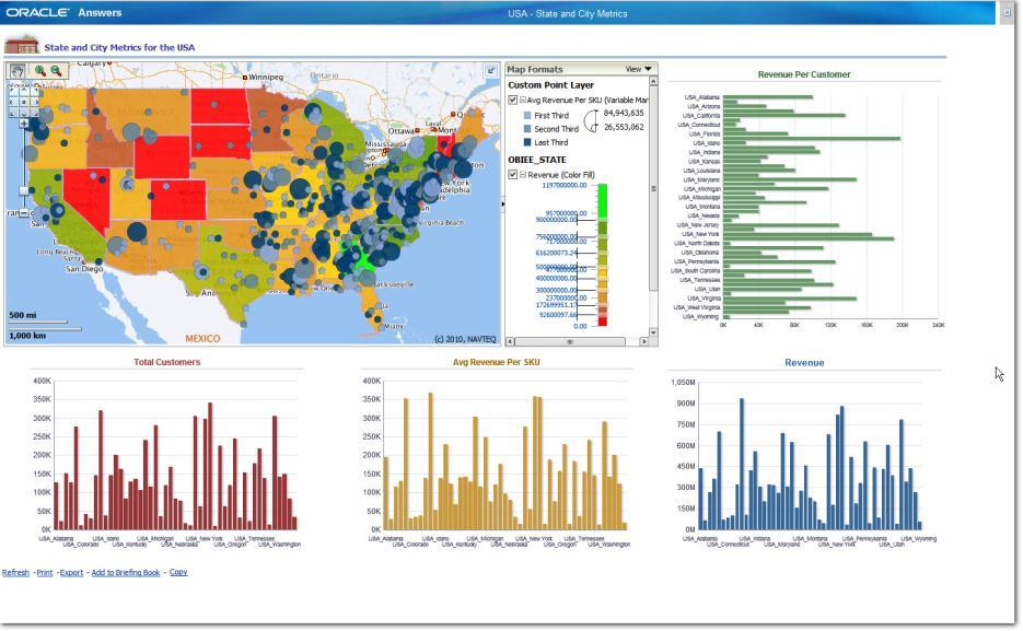
17 Many Ways to Render the Results Color Fill Bar Chart Pie Chart Images Markers Bubble
18 Show MulCple Results on a Map A map can show mulcple facts User can turn facts on or off Demo
19
20 Oracle s Core SpaCal Technologies 20
21 What is SpaCal Data? Business data that contains or describes locacon Geographic features (roads, rivers, parks, etc.) Assets (cell tower, fire hydrant, electrical transformer, etc.) Sales data (sales territory, customer registracon, etc.) Street and postal address (customers, stores, factory, etc.) Anything connected to a physical locacon Almost every database contains some form of business data that can be leveraged using spacal technologies LocaCon is a universal key
22 Data Geocode Analyze Display Manage commercial and customer geospacal data Convert addresses into coordinates Find Proximity, LocaCon, Containment Add Maps & Reports to your ApplicaCon
, geometry SDO_GEOMETRY")
23 SpaCal Tables Just like regular tables Contain a column of type SDO_GEOMETRY to store the geometric shape of the objects CREATE TABLE map_countries ( id NUMBER PRIMARY KEY, name VARCHAR2(30), geometry SDO_GEOMETRY );

 2427, 1003, 1, 2465, 1003, 1, 2511, 1003, 1 ),")

24 SpaCal Data Contains a list of X and Y coordinates for points that describe the shape SQL> SELECT geometry FROM map_countries WHERE name = 'France'; SDO_GEOMETRY( Coordinate system of the 2007, 4326, NULL, shape (here Longitude/ SDO_ELEM_INFO_ARRAY(1, 1003, 1, 2209, 1003, 1, LaCtude) 2427, 1003, 1, 2465, 1003, 1, 2511, 1003, 1 ), SDO_ORDINATE_ARRAY( , , , , , , , , , , , ) ) Coordinates of points that describe the shape

25 Geocoding Generates lactude/longitude (points) from addresses InternaConal addressing standardizacon Formaced and unformaced addresses Tolerance parameters support fuzzy matching SQL and XML APIs Record- level and batch processes Data provided by leading data vendors One Oracle Drive, Nashua NH, 03062


26 SpaCal Analysis Find all compectors within 2 miles of Northport Branch SELECT c.holding_company, c.location FROM competitor c, bank b WHERE b.site_id = 1604 AND SDO_WITHIN_DISTANCE( c.location, b.location, 'distance=2 unit=mile ) = 'TRUE' Map data NAVTEQ
 area FROM us_states s, us_parks p WHERE SDO_ANYINTERACT (s.geom, p.geom) = 'TRUE' AND p.")
27 SpaCal Analysis a more complex example What percentage of Yellowstone is in each state? WITH p AS ( SELECT s.state, sdo_geom.sdo_area ( sdo_geom.sdo_intersection ( s.geom, p.geom, 0.5), 0.5, 'unit=sq_km') area FROM us_states s, us_parks p WHERE SDO_ANYINTERACT (s.geom, p.geom) = 'TRUE' AND p.name = 'Yellowstone NP' ) SELECT state, area, RATIO_TO_REPORT(area) OVER () * 100 AS pct FROM p ORDER BY pct DESC; STATE AREA PCT Wyoming Montana Idaho
 3D")
28 Oracle Locator Included in Oracle Database All EdiCons Support for all 2D geometry types Points, lines, polygons All SpaCal Searches Measurements: distance, area, length UClity, tuning and validacon Full Coordinate Systems support SpaCal processing funccons Oracle SpaCal A cost opcon of Oracle Database Enterprise EdiCon Includes all Locator features + Vector Performance Accelerator (VPA) 3D structures Geocoding Linear Referencing Network Data Model and RouCng engine Raster (imagery and grids) Specialized 3D types (LIDAR, TINS) Web Services (WFS, )


29 Oracle MapViewer Included with all licenses of Oracle Fusion Middleware Embedded with OBIEE Standards- based J2EE and Java Server Faces component XML/HTTP, Java/AJAX Publish spacal data to the web Map and feature cache provides smooth scroll (pan, zoom) Rich Java, XML, JavaScript APIs provide client side interaccvity Centrally managed map definicons, symbology, and styling rules
30 MapViewer Architecture Client (browser) OBIEE Background Maps ApplicaCon JavaScript Map API OBIEE Layers XML/HTTP ApplicaCon Server Tile Cache Tile Cache Server Map Rendering Engine Data Server JDBC Database SpaCal Tables Map DefiniCons Mapbuilder
31 SpaCal Data 31
32 What SpaCal Data do you need? Background Data (OBIEE Background Map) This is used to build maps on which the business data is displayed Roads, rivers, forests, buildings, etc Could also be from satellite or aerial photos. Not always required Provides context for the business data Can come from external providers (Google, ) Business Data (OBIEE Layers) This is the data you need in order to show the results of your BI queries For example: country boundaries, states, provinces, postal code areas, etc.
33 Sources for SpaCal Data Here (Navteq): Oracle Delivery Format (ODF) Plug and play Supplied as transportable tablespaces Two releases a year Ready for use for geocoding, roucng and mapping 200 GB for a full European cover Full street- level details Points of Interest (businesses, public buildings, etc) Data also available from TomTom, GfK and other geospacal data providers (mapping agencies, etc)

34 BI- specific Data AdministraCve boundaries Four levels: countries and three subdivisions For example: France régions, départements, communes Clear hierarchical structure Oracle dumps Postal code boundaries Generalized and non- generalized Postal code centroids Available in ESRI shape files Similar offers also available from GfK and TomTom
 May need to manually fix the names of the spacal regions to match")
35 Using Standard AdministraCve Regions Example: analyzing sales per provinces and province subdivisions Can use standard boundaries (possibly from the free world- sample dataset) But scll need to relate the region codes used in BI with those in the spacal data Can match on names But watch spelling differences (accents, dashes) May need to manually fix the names of the spacal regions to match the BI data Map courtesy of hcp://strangemaps.wordpress.com/


36 Using CombinaCons of Standard AdministraCve Regions Example: the sales regions used by the customer are formed by combining various standard admin regions. Must have a clear definicon of how the customer defines those regions! Construct the customer- specific regions by spacally merging the standard regions. Use spacal processing funccons provided by Oracle SpaCal. Union, interseccon, buffer,

37 Using Other AdministraCve Areas School districts, wards, precincts, vocng districts StaCsCcal units French IRIS codes, US Census Blocks Not available from the usual suppliers GfK has many of those
38 Loading the SpaCal Data Some data provided in Oracle formats Transportable tablespaces, dumps Some provided in GIS files ESRI shapefile is a common format Load using Mapbuilder Other GIS formats If possible, ask for a shapefile copy If not, need more tools Open Source (GDAL) FME (Safe Sovware)
 They are idencfied by their addresses For mapping, they must")
 data set One Oracle Drive, Nashua NH,")
39 LocaCng Individual Business Events Business Events are individual customer locacons (or crime locacons, or network failures, ) They are idencfied by their addresses For mapping, they must be idencfied spacally (using geographical coordinates) This is a process called Geo- coding Requires Oracle SpaCal Requires a geocoding (addresses) data set One Oracle Drive, Nashua NH, 03062


 Could also")
40 Background Maps Provides visual context for business informacon Can be generated from local detailed spacal data Can be provided by external mapping services (Oracle elocacon, Google Maps, ) Could also be imagery


41 Linking Layers and BI data Select the layer to edit Click the edit bucon
42 Select the key column for the spacal theme Use the sampling to verify that the keys match Select the key column for the BI data model
43 Linking Layers and BI data Ideally, match on codes if possible For example ISO country codes 2- lecers (FR) vs 3- lecers (FRA) codes US State codes, French départements, Rarely available for other admin areas Rarely used outside naconal stacsccal offices US FIPS codes, EU NUTS codes Mostly match on names But watch spelling differences (case, accents, dashes) Watch language ( Germany vs Deutschland vs Allemagne ) Will need to manually fix the names of the spacal regions to match the BI data
44 Try it out! Download and install a virtual machine Ready for use. Includes OBIEE and Oracle Database with a full sample applicacon environment. Revisit regularly for new and updated versions Online test drive - shared Shared environment don t change anything hcp://slc02ojw.oracle.com:7780/analyccs/ Online test drive - dedicated Own environment, provided by our partner Vlamis in Amazon AWS Limited to 5 hours hcp:// registracon


45 SampleApp "Explained"


46 Try it out!
47 Upcoming sessions on Maps in Oracle BI Oracle BI and Geo- Spa7al Big Data Tony Heljula, PeakIndicators, UK Geomarke7ng Analysis: for Italy's Leading Supermarket Chain, Unicoop Firenze Michele Sacchi, Bridge ConsulCng, Italy Loca7on Intelligence for Italian and UK Jus7ce and Public Sector Nicola Sandoli, IConsulCng, Italy Available Workshop materials on OTN Create Custom, InteracCve Map VisualizaCons Using Oracle Business Intelligence IntegraCon Frameworks including VirtualBox image and step- by- step guide


48 Learn more from our Channel


49 Resources: Oracle Technology Network blogs.oracle.com " oraclespacal " oracle_maps_blog


50 More Resources

51 CerCficaCon Individual Cer7fica7on, Partner Specializa7on CredenCals for individuals with SpaCal implementacon expercse OPN SpecializaCon differencates partner organizacons delivering SpaCal services Study materials, exam informacon, program guidelines are available at spa7alandgraph/learnmore/spa7al- partners html - Talk to Oracle team this week

52 Q & A
53 53

54
1 Copyright 2011, Oracle and/or its affiliates. All rights reserved.
 1 Copyright 2011, Oracle and/or its affiliates. All rights reserved. ORACLE PRODUCT LOGO S15402 Google Maps, ESRI, Traffic, ipad: Bring it all Together With Oracle Spatial LJ Qian Jayant Sharma Sr. Mgr.,
Map Visualization in Analytic Applications LJ Qian, Director of Software Development David Lapp, Product Manager Oracle
 Map Visualization in Analytic Applications LJ Qian, Director of Software Development David Lapp, Product Manager Oracle Copyright 2015, Oracle and/or its affiliates. All rights reserved. Safe Harbor Statement
Visualizing Data Using Maps in OBI 11g
 Copyright 2010, Vlamis Software Solutions, Inc. Visualizing Data Using Maps in OBI 11g Collaborate 2011 Tim Vlamis Vlamis Software Solutions 816-781-2880 http://www.vlamis.com Copyright 2010, Vlamis Software
May 22, 2013 Ronald Reagan Building and International Trade Center Washington, DC USA
 May 22, 2013 Ronald Reagan Building and International Trade Center Washington, DC USA 1 Introduction to MapViewer & Tools for Your Business Apps and Mobile Devices Albert Godfrind Oracle Spatial Architect
Oracle Spatial Summit 2015 Best Practices for Developing Geospatial Apps for the Cloud
 Oracle Spatial Summit 2015 Best Practices for Developing Geospatial Apps for the Cloud Nick Salem, Distinguished Engineer Neustar Neustar ElementOne OVERVIEW Comprehensive cloud based GIS analytics platform
Copyright 2012, Oracle and/or its affiliates. All rights reserved.
 1 Oracle Spatial and Graph: Technologies 101 Xavier Lopez, Senior Director Product Management, Oracle Server Technologies 2 Program Agenda Introducing Oracle Spatial and Graph Advanced Features New Features
An Oracle White Paper September Oracle Fusion Middleware MapViewer
 An Oracle White Paper September 2014 Oracle Fusion Middleware MapViewer Introduction... 2 Usage Scenarios... 3 Reporting... 3 Proximity Search... 4 Analysis... 5 Brief Feature Overview... 8 Developing
An Overview of FMW MapViewer
 An Overview of FMW MapViewer Agenda What is MapViewer Select Features Getting Started Additional Resources 2 Copyright 2013, Oracle and/or its affiliates. All rights reserved. Oracle
Copyright 2013, Oracle and/or its affiliates. All rights reserved.
 1 What s New in Location Analytics Jayant Sharma Director, Product Mgmt The following is intended to outline our general product direction. It is intended for information purposes only, and may not be
May 2012 Oracle Spatial User Conference
 1 May 2012 Oracle Spatial User Conference May 23, 2012 Ronald Reagan Building and International Trade Center Washington, DC USA Michele Sacchi Bridge Consulting Program Manager Geomarketing Analysis A
An Oracle White Paper January Oracle Fusion Middleware MapViewer 10g ( )
") An Oracle White Paper January 2009 Oracle Fusion Middleware MapViewer 10g (10.1.3.3) Oracle Fusion Middleware MapViewer Disclaimer The following is intended to outline our general product direction. It
An Oracle White Paper January 2009 Oracle Fusion Middleware MapViewer 10g (10.1.3.3) Oracle Fusion Middleware MapViewer Disclaimer The following is intended to outline our general product direction. It
An Oracle White Paper July Oracle Fusion Middleware MapViewer 12c
 An Oracle White Paper July 2016 Oracle Fusion Middleware MapViewer 12c Oracle Fusion Middleware MapViewer 12c Introduction... 2 Usage Scenarios... 3 Reporting... 3 Proximity Search... 3 Analysis... 5 Feature
Copyright 2012, Oracle and/or its affiliates. All rights reserved.
 1 Real Life Applications of Location Analytics Dan Geringer, Senior Software Development Manager, Oracle Jayant Sharma, Director Prod Mgmt, Oracle 2 The following is intended to outline our general product
DOAG CONFERENCE Data Warehouse & Business Intelligence. November 22, 2012 NürnbergConvention Center Ost Nürnberg
 November 2012 DOAG CONFERENCE Data Warehouse & Business Intelligence November 22, 2012 NürnbergConvention Center Ost Nürnberg Michele Sacchi Bridge Consulting Program Manager Geomarketing Analysis A developed
Best Practices, Tips and Tricks With Oracle Spatial and Graph Daniel Geringer, Spatial Solutions Specialist Oracle Corporation
 Best Practices, Tips and Tricks With Oracle Spatial and Graph Daniel Geringer, Spatial Solutions Specialist Oracle Corporation Spatial Vector Acceleration Oracle Confidential Internal/Restricted/Highly
May 21, 2014 Walter E. Washington Convention Center Washington, DC USA. Copyright 2014, Oracle and/or its affiliates. All rights reserved.
 May 21, 2014 Walter E. Washington Convention Center Washington, DC USA 1 Innovation in Spatial Data Processing Hans Viehmann Product Manager EMEA The following is intended to outline our general product
May 22, 2013 Ronald Reagan Building and International Trade Center Washington, DC USA
 May 22, 2013 Ronald Reagan Building and International Trade Center Washington, DC USA 1 Building Applications with Oracle MapViewer LJ Qian (lj.qian@oracle.com) Director, Software Development The following
IT Infrastructure for BIM and GIS 3D Data, Semantics, and Workflows
 IT Infrastructure for BIM and GIS 3D Data, Semantics, and Workflows Hans Viehmann Product Manager EMEA ORACLE Corporation November 23, 2017 @SpatialHannes Safe Harbor Statement The following is intended
Welkom bij de themasessie Oracle Spatial 11g
 Welkom bij de themasessie Oracle Spatial 11g OGh SIM Commissie Agenda 19:00-19:05 Welkom 19:05-19:35 Managing ALL your Information in 11g (Han Wammes) 19:35-20:15 Oracle Spatial 11g
Oracle Spatial Technologies: An Update. Xavier Lopez Director, Spatial Technologies Oracle Corporation
 Oracle Spatial Technologies: An Update Xavier Lopez Director, Spatial Technologies Oracle Corporation Overview Oracle Approach to Market Specialist v. Generalist Solutions New Developments: Oracle Database
Leverage custom geographical polygons in SAS Visual Analytics
 ABSTRACT Paper SAS1732-2018 Leverage custom geographical polygons in SAS Visual Analytics Falko Schulz, SAS Institute Inc., Brisbane, Australia Discover how you can explore geographical maps using your
Best Practices for Designing Effective Map Services
 2013 Esri International User Conference July 8 12, 2013 San Diego, California Technical Workshop Best Practices for Designing Effective Map Services Ty Fitzpatrick Tanu Hoque What s in this session Map
Verarbeitung von Vektor- und Rasterdaten auf der Hadoop Plattform DOAG Spatial and Geodata Day 2016
 Verarbeitung von Vektor- und Rasterdaten auf der Hadoop Plattform DOAG Spatial and Geodata Day 2016 Hans Viehmann Product Manager EMEA ORACLE Corporation 12. Mai 2016 Safe Harbor Statement The following
An Introduction to Oracle s Location Technologies ORACLE WHITE PAPER MARCH 2017
 An Introduction to Oracle s Location Technologies ORACLE WHITE PAPER MARCH 2017 Disclaimer The following is intended to outline our general product direction. It is intended for information purposes only,
ORACLE FUSION MIDDLEWARE MAPVIEWER
 ORACLE FUSION MIDDLEWARE MAPVIEWER 10.1.3.3 MAPVIEWER KEY FEATURES Component of Fusion Middleware Integration with Oracle Spatial, Oracle Locator Support for two-dimensional vector geometries stored in
BEST PRACTICES FOR DEVELOPING GEOSPATIAL BIG DATA APPS FOR THE CLOUD. Nick Salem - Distinguished Engineer David Tatar - Principal Software Engineer
 BEST PRACTICES FOR DEVELOPING GEOSPATIAL BIG DATA APPS FOR THE CLOUD Nick Salem - Distinguished Engineer David Tatar - Principal Software Engineer SPEAKER BIO NICK SALEM 18 Oracle Certified Professional
Best Practices for Designing Effective Map Services
 FedGIS Conference February 24 25, 2016 Washington, DC Best Practices for Designing Effective Map Services James Tedrick, Esri Matt Sokol, MD Dept. of Information Technology Web Mapping & Service Types
Oracle Spatial Summit 2015 Effectively Integrate Geospatial Technologies from GIS to Oracle Spatial in Real Estate Sector
 Effectively Integrate Geospatial Technologies from GIS to in Real Estate Sector Francisco Javier Rojas Duran, IT Project Manager Professional DASOFT DASOFT RUV (Housing Registry Authority) - SACP OVERVIEW
Real-Time & Big Data GIS: Leveraging the spatiotemporal big data store
 Real-Time & Big Data GIS: Leveraging the spatiotemporal big data store Suzanne Foss Product Manager, Esri sfoss@esri.com Ricardo Trujillo Real-Time & Big Data GIS Developer, Esri rtrujillo@esri.com @rtrujill007
May 21, 2014 Walter E. Washington Convention Center Washington, DC USA. Copyright 2014, Oracle and/or its affiliates. All rights reserved.
 May 21, 2014 Walter E. Washington Convention Center Washington, DC USA 1 How to Build a Better GIS Application Siva Ravada Senior Director of Development Spatial and Graph & MapViewer Oracle Program Agenda
Oracle 10g GeoSpatial Technologies. Eve Kleiman Asia/Pacific Spatial Product Manager Oracle Corporation
 Oracle 10g GeoSpatial Technologies Eve Kleiman Asia/Pacific Spatial Product Manager Oracle Corporation Eve.Kleiman@oracle.com Agenda Market and Technology Trends Oracle GeoSpatial Technology Stack What
What s New in ArcGIS Server 10
 What s New in ArcGIS Server 10 Derek Law ArcGIS Server Product Management What s s new in ArcGIS Server 10? Agenda Highlights: Enhanced Web mapping More powerful server-based analysis Geo-collaboration
Technology Platform. Spectrum. Version 10.0 SP1. Spectrum Spatial Getting Started Guide
 Spectrum Version 10.0 SP1 Technology Platform Table of Contents 1 - What Is Location Intelligence? 2 - What is Spectrum Spatial? Spectrum Spatial Concepts 5 3 - Modules and Stages Location Intelligence
Introduction to JavaScript. Evan Caldwell & James Tedrick
 Introduction to JavaScript Evan Caldwell & James Tedrick Agenda Getting Started - Meet the Esri API for JavaScript! - Meet Dojo! - Tools of the trade My First App JS API fundamentals How JS apps work Where
Developing Loca.on- enabled Enterprise Applica.ons
 Developing Loca.on- enabled Enterprise Applica.ons On- premise, cloud, or mobile September 28 October 2, 2014 San Francisco Jayant Sharma, Liujian Qian Director Spa.al Product Development September 29,
Spatial data and QGIS
 Spatial data and QGIS Xue Jingbo IT Center 2017.08.07 A GIS consists of: Spatial Data. Computer Hardware. Computer Software. Longitude Latitude Disease Date 26.870436-31.909519 Mumps 13/12/2008 26.868682-31.909259
Lily: A Geo-Enhanced Library for Location Intelligence
 Lily: A Geo-Enhanced Library for Location Intelligence 15th International Conference on Data Warehousing and Knowledge Discovery (DaWaK'13) August 26, 2013 Matteo Golfarelli Stefano Rizzi Marco Mantovani
Introduction to Autodesk MapGuide EnterpriseChapter1:
 Chapter 1 Introduction to Autodesk MapGuide EnterpriseChapter1: In this chapter, you review the high-level key components that comprise Autodesk MapGuide Enterprise. The Autodesk MapGuide Studio, an integral
Introduction to GeoServer
 Tutorial ID: This tutorial has been developed by BVIEER as part of the IGET web portal intended to provide easy access to geospatial education. This tutorial is released under the Creative Commons license.
Oracle Spatial 11g Specialization Sam Sharp, Senior Director
 ORACLE PRODUCT OGO Oracle Spatial 11g Specialization Sam Sharp, Senior Director 1 Copyright 2014, Oracle and/or its affiliates. All rights reserved. Agenda Specialization Benefits & Resources Oracle Spatial
Using ArcGIS for Server. Javier Abadía, Esri España Peter McDaid, Esri UK
 Using ArcGIS for Server Javier Abadía, Esri España Peter McDaid, Esri UK 1. Intro 2. ArcGIS for Server = Geospatial Apps Server 3. Map Services Publishing Flow Apps 4. Spatial Functionality Services Publishing
ArcGIS Enterprise: An Introduction. Philip Heede
 Enterprise: An Introduction Philip Heede Online Enterprise Hosted by Esri (SaaS) - Upgraded automatically (by Esri) - Esri controls SLA Core Web GIS functionality (Apps, visualization, smart mapping, analysis
Deploying Spatial Applications in Oracle Public Cloud
 Deploying Spatial Applications in Oracle Public Cloud David Lapp, Product Manager Oracle Spatial and Graph Oracle Spatial Summit at BIWA 2017 Safe Harbor Statement The following is intended to outline
ORACLE SPATIAL DATABASE WITH MAPVIEWER AND MAP BUILDER FOR DESGINING SPATIAL APPLICATION OF THAPAR UNIVERSITY
 ORACLE SPATIAL DATABASE WITH MAPVIEWER AND MAP BUILDER FOR DESGINING SPATIAL APPLICATION OF THAPAR UNIVERSITY Thesis submitted in partial fulfillment of the requirements for the award of degree of Master
ESRI Technology Update. Joe Holubar Larry Young
 ESRI Technology Update Joe Holubar Larry Young Continued Improvement Improving Quality and Extending and Refining Functionality First Half of 2009: Minor Update Release (ArcGIS 9.3.1) ArcGIS Explorer Fall
Geodatabases. Dr. Zhang SPRING 2016 GISC /03/2016
 Geodatabases Dr. Zhang SPRING 2016 GISC 1401 10/03/2016 Using and making maps Navigating GIS maps Map design Working with spatial data Spatial data infrastructure Interactive maps Map Animations Map layouts
How to create geojson out of an image for using it as map layer in Oracle Data Visualization
 How to create geojson out of an image for using it as map layer in Oracle Data Visualization In this document we will discuss about how to convert an image to a geojson file format. Many a time BI users
Developers Road Map to ArcGIS Desktop and ArcGIS Engine
 Developers Road Map to ArcGIS Desktop and ArcGIS Engine Core ArcObjects Desktop Team ESRI Developer Summit 2008 1 Agenda Dev Summit ArcGIS Developer Opportunities Desktop 9.3 SDK Engine 9.3 SDK Explorer
Introduction to Geodatabase and Spatial Management in ArcGIS. Craig Gillgrass Esri
 Introduction to Geodatabase and Spatial Management in ArcGIS Craig Gillgrass Esri Session Path The Geodatabase - What is it? - Why use it? - What types are there? - What can I do with it? Query Layers
Class #2. Data Models: maps as models of reality, geographical and attribute measurement & vector and raster (and other) data structures
 data structures") Class #2 Data Models: maps as models of reality, geographical and attribute measurement & vector and raster (and other) data structures Role of a Data Model Levels of Data Model Abstraction GIS as Digital
Class #2 Data Models: maps as models of reality, geographical and attribute measurement & vector and raster (and other) data structures Role of a Data Model Levels of Data Model Abstraction GIS as Digital
Key Terms. Attribute join Target table Join table Spatial join
 Key Terms Attribute join Target table Join table Spatial join Lect 10A Building Geodatabase Create a new file geodatabase Map x,y data Convert shape files to geodatabase feature classes Spatial Data Formats
Designing and Using Cached Map Services
 Esri International User Conference San Diego, California Technical Workshops July 2012 Designing and Using Cached Map Services Sterling Quinn Eric Rodenberg What we will cover Session Topics - Map cache
Viewer Features. DataBC Mashup Framework (DMF)
") Viewer Features DataBC Mashup Framework (DMF) Copyright 2014 Ministry of Labour, Citizens' Services and Open Government All Rights Reserved. Printed in Canada The information contained in this document
Viewer Features DataBC Mashup Framework (DMF) Copyright 2014 Ministry of Labour, Citizens' Services and Open Government All Rights Reserved. Printed in Canada The information contained in this document
Android Team Awareness Kit (ATAK) and ArcGIS
 and ArcGIS") Android Team Awareness Kit (ATAK) and ArcGIS Darron Pustam Product Manager, Esri Craig Cleveland Product Engineer, Esri Verne LaClair Product Manager, PAR Agenda Connecting Intel and Operations in Real
Android Team Awareness Kit (ATAK) and ArcGIS Darron Pustam Product Manager, Esri Craig Cleveland Product Engineer, Esri Verne LaClair Product Manager, PAR Agenda Connecting Intel and Operations in Real
Working with Feature Layers. Russell Brennan Gary MacDougall
 Working with Feature Layers Russell Brennan Gary MacDougall Working with Feature Layers Session will focus on feature access and editing Highlight new features added over the last few releases Agenda Introduction
Introduction to Autodesk MapGuide EnterpriseChapter1:
 Chapter 1 Introduction to Autodesk MapGuide EnterpriseChapter1: In this chapter, you review the high-level key components that make up Autodesk MapGuide Enterprise. The Autodesk MapGuide Studio, an integral
Rich Web UI made simple Building Data Dashboards without Code
 Rich Web UI made simple Building Data Dashboards without Code Dana Singleterry http://blogs.oracle.com/dana Product Manager Oracle JDeveloper and Oracle ADF 2 Copyright 2012, Oracle and/or its affiliates.
US Census Bureau Geographic Support System Initiative Partnership Program
 OVERVIEW Centrally managed, authoritative database (MAF/TIGER) Centrally managed Partnership Program SDE geodatabase Supports all censuses and surveys CHALLENGES / OPPORTUNITIES Need for centralized repository
Real-Time & Big Data GIS: Best Practices. Suzanne Foss Josh Joyner
 Real-Time & Big Data GIS: Best Practices Suzanne Foss Josh Joyner ArcGIS Enterprise With Real-time Capabilities Desktop Apps APIs visualization ingestion dissemination & actuation analytics storage Agenda:
Setup Guide for Op Tracker
 Setup Guide for Op Tracker Contents 1 Welcome to Op Tracker... 2 2 Data Overview... 3 2.1 Block Boundary Feature Layer... 3 2.2 Block Tracking Feature Layer... 3 2.3 Ancillary Data Feature Layer... 3 2.4
Development of Java Plug-In for Geoserver to Read GeoRaster Data. 1. Baskar Dhanapal CoreLogic Global Services Private Limited, Bangalore
 Development of Java Plug-In for Geoserver to Read GeoRaster Data 1. Baskar Dhanapal CoreLogic Global Services Private Limited, Bangalore 2. Bruce Thelen CoreLogic Spatial Solutions, Austin, USA 3. Perumal
How to Create a Tile Package
 United States Department of Agriculture Digital Mobile Sketch Mapping (DMSM) How to Create a Tile Package (TPK) Forest Service Introduction A tile package (.tpk) allows you to use a set of packaged tiles
Overview of SAS/GIS Software
 3 CHAPTER 1 Overview of SAS/GIS Software Introduction to Geographic Information Systems 3 Features of SAS Software 4 Data in SAS/GIS Applications 5 Spatial Data 5 Spatial Data Layers 6 Spatial Data Coverages
What s New in TerraExplorer Suite 5.0
 What s New in TerraExplorer Suite 5.0 The new release of the TerraExplorer Suite marks major improvements in the capabilities for working with GIS layers. A new streaming mechanism allows connection to
GIS Basics for Urban Studies
 GIS Basics for Urban Studies Date: March 21, 2018 Contacts: Mehdi Aminipouri, Graduate Peer GIS Faciliator, SFU Library (maminipo@sfu.ca) Keshav Mukunda, GIS & Map Librarian Librarian for Geography (kmukunda@sfu.ca)
ArcGIS Online: Managing Data. Jeremy Bartley Sentha Sivabalan
 ArcGIS Online: Managing Data Jeremy Bartley (jbartley@esri.com) Sentha Sivabalan (ssivabalan@esri.com) Agenda Creating and managing content like Apps, Maps, Scenes and Layers in ArcGIS Today s Topics:
BROWSER. LuciadRIA DATA SHEET
 BROWSER LuciadRIA DATA SHEET V2017 V2017.0 DATA SHEET LuciadRIA is the answer to today s demands for powerful, lightweight applications in the browser. Driven by today s most advanced web technologies,
Lidar Working with LAS Datasets
 2013 Esri International User Conference July 8 12, 2013 San Diego, California Technical Workshop Lidar Working with LAS Datasets Raghav Vemula (3D Team) Esri UC2013. Technical Workshop. Agenda Las Dataset
Georeferencing. Georeferencing: = linking a layer or dataset with spatial coordinates. Registration: = lining up layers with each other
 Georeferencing How do we make sure all our data layers line up? Georeferencing: = linking a layer or dataset with spatial coordinates Registration: = lining up layers with each other Rectification: The
May 2012 Oracle Spatial User Conference
 1 May 2012 Oracle Spatial User Conference May 23, 2012 Ronald Reagan Building and International Trade Center Washington, DC USA Siva Ravada Director of Development Oracle Spatial Steve MacCabe Product
May 22, 2013 Ronald Reagan Building and International Trade Center Washington, DC USA
 May 22, 2013 Ronald Reagan Building and International Trade Center Washington, DC USA 1 To 9. D 1. 2. 3. Leveraging Advanced Oracle Spatial and Graph Features Daniel Geringer Senior Software Development
Publishing Statistical Data and Geospatial Data as Linked Data Creating a Semantic Data Platform
 Publishing Statistical Data and Geospatial Data as Linked Data Creating a Semantic Data Platform Hans Viehmann Product Manager EMEA ORACLE Corporation January 22, 2017 @SpatialHannes Safe Harbor Statement
3D in the ArcGIS Platform. Chris Andrews
 3D in the ArcGIS Platform Chris Andrews Geospatial 3D is already all around us 3D is expanding the GIS community s opportunity to provide value 3D City & Infrastructure Models Generated 3D features Photogrammetrc
Oracle Fusion Middleware MapViewer Primer. An Oracle White Paper April 2012
 Oracle Fusion Middleware MapViewer Primer An Oracle White Paper April 2012 Oracle Fusion Middleware MapViewer Primer Introduction... 3 What Is MapViewer... 3 What is Oracle Maps... 4 Setting up your MapViewer
Geographical Information Systems Institute. Center for Geographic Analysis, Harvard University. LAB EXERCISE 1: Basic Mapping in ArcMap
 Harvard University Introduction to ArcMap Geographical Information Systems Institute Center for Geographic Analysis, Harvard University LAB EXERCISE 1: Basic Mapping in ArcMap Individual files (lab instructions,
U.S. Census Bureau Spatial Data Storage and Topology in the Redesigned MAF/TIGER System Jennifer DeVore and Danielle Lessard March 10, 2005
 US Census Bureau Spatial Data Storage and Topology in the Redesigned MAF/TIGER System Jennifer DeVore and Danielle Lessard March 10, 2005 What is TIGER? Topologically Integrated Geocoding and Referencing
Technology Platform. Spectrum. Version 11.0 SP1. Spectrum Spatial Getting Started Guide
 Spectrum Version 11.0 SP1 Technology Platform Table of Contents 1 - What Is Location Intelligence? 2 - What is Spectrum Spatial? Spectrum Spatial Concepts 5 3 - Modules and Stages Location Intelligence
Raster Serving with ArcGIS
 Raster Serving with ArcGIS Agenda Introduction to server technology Workflow considerations ESRI raster serving technology ArcGIS Server Basic (ArcSDE) ArcGIS Server Standard/Advanced Web Services ArcGIS
LSGI 521: Principles of GIS. Lecture 5: Spatial Data Management in GIS. Dr. Bo Wu
 Lecture 5: Spatial Data Management in GIS Dr. Bo Wu lsbowu@polyu.edu.hk Department of Land Surveying & Geo-Informatics The Hong Kong Polytechnic University Contents 1. Learning outcomes 2. From files to
STORE LOCATOR USER GUIDE Extension version: 1.0 Magento Compatibility: CE 2.0
 support@magestore.com sales@magestore.com Phone: +1-606-657-0768 STORE LOCATOR USER GUIDE Extension version: 1.0 Magento Compatibility: CE 2.0 Table of Contents 1. INTRODUCTION 3 Outstanding Features...3
NoSQL Databases. Vincent Leroy
 NoSQL Databases Vincent Leroy 1 Database Large-scale data processing First 2 classes: Hadoop, Spark Perform some computacon/transformacon over a full dataset Process all data SelecCve query Access a specific
Getting Started with ArcGIS Runtime. Jeff Shaner David Cardella
 Getting Started with ArcGIS Runtime Jeff Shaner David Cardella Agenda ArcGIS Runtime SDK Overview WPF SDK Java SDK ios, Android, Win Phone SDKs Road Ahead Making ArcGIS available from any device anywhere
MAKING THE BUSINESS CASE MOVING ORACLE FORMS TO THE WEB
 MAKING THE BUSINESS CASE MOVING ORACLE FORMS TO THE WEB About Us Agenda Strategic Direction of Oracle Forms Applications Migration Options Migrating to 10g and 11g Migrating to J2EE and ADF Migrating to
Desktop. ArcGIS Server. ArcGIS
 Getting Started with ArcGIS Server Nakul Bhatia and David Crosby ESRI Charlotte 1 Agenda g Overview of ArcGIS Server 9.3.1 Working with GIS Services Using g Web GIS Service Clients ArcGIS Online Map Caching
Developing Qt Apps with the Runtime SDK
 Developing Qt Apps with the Runtime SDK Thomas Dunn and Michael Tims Esri UC 2014 Technical Workshop Agenda Getting Started Creating the Map Geocoding and Routing Geoprocessing Message Processing Work
ArcGIS Hub: Open data best practices. Graham Hudgins, esri product engineer
 ArcGIS Hub: Open data best practices Graham Hudgins, esri product engineer Agenda Overview of open data in the ArcGIS Hub Example sites - Hubs Around the World Storymap Making a good site map Preparing
Basic Queries Exercise - Haiti
 Basic Queries Exercise - Haiti Written by Barbara Parmenter, revised by Carolyn Talmadge on September 18, 2016 SETTING UP... 1 WHERE ARE THE HOSPITALS THAT ARE STILL OPERATING? (SELECT BY ATTRIBUTE )...
Land Information Management and its (3D) Database Foundation
 Database Foundation") Land Information Management and its (3D) Database Foundation Han Wammes, Oracle Netherlands November 18 th, 2011 1 Copyright 2011, Oracle and/or its affiliates. All rights Safe Harbor Statement The following
Land Information Management and its (3D) Database Foundation Han Wammes, Oracle Netherlands November 18 th, 2011 1 Copyright 2011, Oracle and/or its affiliates. All rights Safe Harbor Statement The following
Copyright 2010, Oracle. All rights reserved.
 Agenda Interactive Dashboards Master-Detail Linking New Prompt Controls Pivot Table Interactions Enhanced Dashboard Builder Analysis Editor Overview Working with the analysis editor step by step Praxisteil
SAGIS Property Map Viewer Instruction Manual Instructions for using the SAGIS Property Map Viewer. Published December 21, 2018.
 SAGIS Property Map Viewer Instruction Manual www.sagis.org/map Instructions for using the SAGIS Property Map Viewer. Published December 21, 2018. 1 Instructional Videos Click on a link to watch a video
Release Notes. Spectrum Spatial Analyst Version 7.0. Contents:
 Location Intelligence Spectrum Spatial Analyst Version 7.0 This document contains information about Pitney Bowes Spectrum Spatial Analyst Release 7.0. Contents: What s new in Spectrum Spatial Analyst?
PeopleSoft Pivot Grids A through Z!
 PeopleSoft Pivot Grids A through Z! Session ID: 101480 Prepared by: Millie Babicz, SpearMC Consulting @SpearMC Agenda About Us Pivot Grid Overview Pivot Grid Wizard Use of Pivot Grid in Work Centers 2
Manitowoc County, WI Advanced Access GIS Viewer User Documentation
 Manitowoc County, WI Advanced Access GIS Viewer User Documentation Introduction Extensive time was put into developing this website both from a display, and from a printing and scaling perspective. This
Map Library ArcView Version 1 02/20/03 Page 1 of 12. ArcView GIS
 Map Library ArcView Version 1 02/20/03 Page 1 of 12 1. Introduction 1 ArcView GIS ArcView is the most popular desktop GIS analysis and map presentation software package.. With ArcView GIS you can create
Getting Started with ArcGIS for Server. Charmel Menzel and Ken Gorton
 Getting Started with ArcGIS for Server Charmel Menzel and Ken Gorton Agenda What is ArcGIS for Server? Types of Web services Publishing resources onto the Web Clients to ArcGIS for Server Editions and
Vision-e 19 Gloria Lane Fairfield, NJ
 Version.0 Section Page 1.0 Manage User Licenses 3 1.1 Geocoding Your Records 4 1.2 Enabling Custom Objects 5 1.3 Create a Map 5 1.4 Import Report 6 1.5 Edit a Map 6 1.6 Clone a Map 7 1.7 Delete a Map 7
Using ESRI data in Autodesk ISD Products
 GI13-3 Using ESRI data in Autodesk ISD Products 1.5 hr. Class 02-Dec-03 3:30pm - 5:00pm Session Description: We will focus on using data in a variety of ESRI formats within the Autodesk GIS product line,
High Performance Raster Database Manipulation and Data Processing with Oracle Spatial and Graph
 High Performance Raster Database Manipulation and Data Processing with Oracle Spatial and Graph Qingyun (Jeffrey) Xie Senior Manager of Software Development Oracle Corporation Safe Harbor Statement The
What is coming in. ArcGIS Server 10. Ismael Chivite ArcGIS Server Product Manager James Cardona Technical Marketing
 What is coming in ArcGIS Server 10 Ismael Chivite ArcGIS Server Product Manager James Cardona Technical Marketing ArcGIS Server is a complete server based GIS Delivering GIS with powerful services and
Leveraging OGC Services in ArcGIS Server. Satish Sankaran, Esri Yingqi Tang, Esri
 Leveraging OGC Services in ArcGIS Server Satish Sankaran, Esri Yingqi Tang, Esri GIS Creating and Managing Geo Information Products - Proprietary - Open Specifications - Standards Dissemination of Geo