ISPRS Hannover Workshop 2013, May 2013, Hannover, Germany
|
|
|
- Gabriel Milton Sanders
- 5 years ago
- Views:
Transcription

1 New light-weight stereosopic spectrometric airborne imaging technology for highresolution environmental remote sensing Case studies in water quality mapping E. Honkavaara, T. Hakala, K. Nurminen, L. Markelin, Finnish Geodetic Institute J. Kirjasniemi, P. Ruokokoski, Lentokuva Vallas Oy A. Lindfors, Luode Consulting Oy J. Mäkynen, H. Saari, VTT Technical Research Center Finland ISPRS Hannover Workshop 2013, May 2013,


2 Content Introduction New imaging technology Empirical investigation Conclusions In co-operation Lentokuva Vallas Oy, Luode Consulting Oy, VTT Technical Research Center Finland Acknowledgement: This work was carried out partially in the MMEA research program coordinated by Cleen Ltd. with funding from the Finnish Funding Agency for Technology and Innovation, Tekes 2
3 Introduction New light-weight Fabry-Perot interferometer based camera technology Data cubes with adjustable spectral properties in a rectangular image format Weigh 600 g -> suitable for light Unmanned Airborne Vehicles (UAVs) and light Manned Airborne Vehicles (MAVs) Objective: To investigate and develop processing and use of the FPI imaging technology in environmental remote sensing and monitoring applications 3D-geometry, object reflectance signatures Measurement and processing in all weather conditions Previous studies in precision agriculture using 2011 and 2012 prototypes Case studies in water quality mapping Objective is to develop a fast and cost-efficient method to provide highresolution data from complex environments where the use of traditional sampling methods is limited, such as lakes, rivers and harbour areas Assessment of its potential in measurement and monitoring of various water quality parameters algae blooms, turbidity, organic carbon, total phosphorus concentrations, chlorophyll-a 3
4 FPI spectral camera technology 4
 Custom optics, CMOS detector Image size: 1024 x 648 pixels (2xbinned), Pixel 11 μm C=10.9 mm, F-number < 3.")
5 Fabry-Perot interferometer based tuneable spectral imager, 2012 prototype Hyperspectral imagtery in frame format Spectral data cube by changing the width of Fabry-Perot air gap Developed by VTT Technical Research Finland (Heikki Saari et al.) Custom optics, CMOS detector Image size: 1024 x 648 pixels (2xbinned), Pixel 11 μm C=10.9 mm, F-number < 3.0 Application based filter selection between nm , , , , nm Spectral resolution FWHM ISPRS Hannover Workshop 2013, May 2013, 5


6 UAV operation UAV Autopilot IMU GPS Payload Spectral imager High spatial resolution imager GPS Irradiance sensors Ground control station Mission design and control Insitu reference measurements: irradiance, reflectance targets, In typical flight data cubes with spectral layers Georeferencing data Irradiance data Insitu data 6
7 Processing of FPI image data Desired output product: water leaving spectral reflectance mosaic Rigorous FPI spectral data cube generation is the basis for further processes Geometric processing with standard photogrammetric methods: orientations, DSMs New processing is developed for radiometric model calculation using frame format images Output products: DSMs, spectrometric point clouds, spectrometric image mosaics, spectrometric stereoscopic data 7


8 Spectral data cube generation Sensor radiometric and spectral calibration in laboratory using an integrating sphere and monochromator by VTT Spectral smile correction Layer matching Geometric transformation by using feature based matching to a single reference layer. Affine or projective transformation. Strategy: Reference layer for each spctral region, apriori matching in layer order Quality statistics: Standard deviations of model parameters, magnitudes of parameters, residuals G R NIR 8


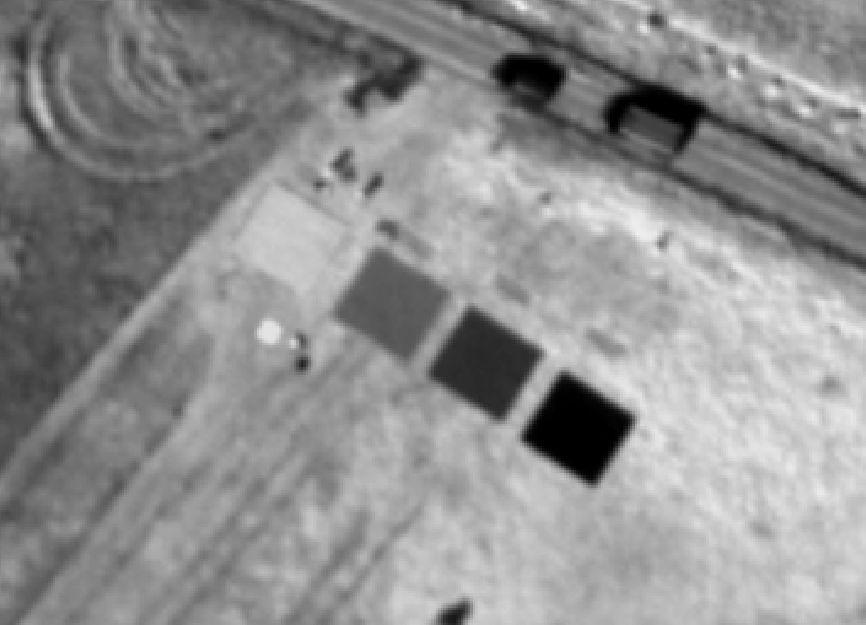
9 A new method for reflectance image generation of frame images Data Overlapping spectral rectangle format data cubes Tasks Eliminate radiometric disturbances caused by sensor instability and illumination/atmosphere BRDF compensation Reflectance calibration Approach Radiometric model parameters using radiometric block adustment with a network of radiometric tie points Optional insitu irradiance measurements Reflectance images using reflectance targets Light source Observer C G E i r D A A B φ r North F φ i O 9


10 Output products: DSMs, hyperspectral image mosaics, hyperspectral point clouds Honkavaara, E., et. al. 2012b. Hyperspectral reflectance signatures and point clouds for precision agriculture by light weight UAV imaging system, ISPRS Ann. Photogramm. Remote Sens. Spatial Inf. Sci., I-7, , doi: /isprsannals-i , 2012.

11 Empirical study Campaigns by UAV and MAV in lake Petäjärvi, Sjökulla Shallow lake in agricultural area extending to an area of 2 km by 2 km 11


12 UAV Campaign, Helicopter UAV, 4 kg payload, autopilot Flight parameters according to legistlation in Finland: Flying height 150 m, GSD 15 cm; Visual control by UAV pilot FPI spectral camera Filters nm, nm and nm, spectral bands Continuos interval mode Weather: Fluctuating cloudiness Insitu data Water quality measurements by Luode Consulting Oy Spectral reference targets and measurements by FGI 12


13 MAV campaign using single-engine aircraft, By Lentokuva Vallas Oy, OH-CNU, Cessna 172 Reims Rocket Block Height: 440 m over terrain, Speed 39 m/s, 2 km x 4 km = 8 km 2, 10 lines, 200 m Flight line spacing Overlaps: 63%, 56% GSD: 45 cm 14 ms integration times, image interval > 2 s, Filter nm, 20 channels Weather: Cloudy, rainy Insitu data Sjökulla test site Ground reflectance reference data with Avantes hand held spectrometer Water quality measurements by Luode Oy Lentokuva Vallas Oy Lentokuva Vallas Oy 13

14 UAV and MAV campaigns at Sjökulla/Petäjärvi in 2012 UAV MAV 14
15 Results 15

16 Signal-to-noise ratio MAV 45 cm UAV 15 cm 16

17 Georeferencing using national open topographic orthophotos and DSMs Geoferencing a block with a threelayer image, apply the orientations to layer matched datacubes Ground reference: national open digital surface models and orthophotos, 90 GCPs GPS data was not used Orientations for images containing only water by interpolation from adjacent images Bae Systems Socet Set environment Automatic tie point measurement Self-calibrating bundle block adjustment σ0 = 0.5 m RMS at GCPs: X: 0.69 m, Y: 0.70 m, Z: 0.18 m The National Land Survey of Finland, Colour orthophoto and Elevation model 10 m, 01/2013, ata_licence_version1_


18 Reflectance images of MAV data Extensive illumination variations during the flight, water shower in the middle of the flight Radiometric block adjustment Relative shift correction or relative multiplicative correction Reflectance transformation using empirical line method Coefficient of variation in radiometric tie points without corrections, with corrections Potential shadowing by the floor hole was uncorrected No correction Relative multiplicative 18

19 Vegetation and soil reflectance Insitu measurement: rain seriously descreased reflectance The FPI reflectance followed quite well the reference reflectance 19


20 Lake reflectance from MAV data G R NIR Reflectance in 3 m x 3 m image window Reflectance is influenced by algae blooms and turbidity Further analysis is in operation 20


21 MAV and UAV spectral data cube mosaics MAV mosaic, GSD 1 m , rainy weather UAV mosaic, GSD 20 cm , sunny weather 21
22 Conclusions Preliminary results of the FPI spectral camera in water quality mapping application were presented. Data analysis will continue. Very promising technology High spatial resolution, stereoscopic, spectrometric image data FPI camera is operational from dynamic, light-weight, UAV platforms, suitable also for operation from MAV platform Can be operated in difficult illumination conditions: under clouds, rain Well suited for time-critical and monitoring applications, such as water quality, agriculture, mining environments, disasters UAV operation best suited for areas <25 ha (depending on legistlation), MAV for larger areas Radiometric processing technology for images collected in diverse weather conditions is needed, radiometric aspects need to be carefully considered Ongoing studies at FGI Improving radiometric and geometric processing Procedure for SI-traceable UAV reflectance measurements Analysis in forests, agriculture, water environment, mining environment 22
23 Thank you! 23
Sensors and applications for drone based remote sensing
 Sensors and applications for drone based remote sensing Dr. Ilkka Pölönen Dr. Eija Honkavaara, NLS Dr. Heikki Saari, VTT Dr. Sakari Tuominen, Mr. Jere Kaivosoja, Luke Laboratory Joint research with Finnish
This is an electronic reprint of the original article. This reprint may differ from the original in pagination and typographic detail.
 This is an electronic reprint of the original article. This reprint may differ from the original in pagination and typographic detail. Author(s): Hakala, Teemu; Honkavaara, Eija; Saari, Heikki; Mäkynen,
This is an electronic reprint of the original article. This reprint may differ from the original in pagination and typographic detail.
 This is an electronic reprint of the original article. This reprint may differ from the original in pagination and typographic detail. Author(s): Honkavaara, Eija; Saari, Heikki; Kaivosoja, Jere; Pölönen,
This is an electronic reprint of the original article. This reprint may differ from the original in pagination and typographic detail.
 This is an electronic reprint of the original article. This reprint may differ from the original in pagination and typographic detail. Author(s): Honkavaara, E.; Hakala, T.; Markelin, L.; Jaakkola, A.;
ASSESSMENT OF VARIOUS REMOTE SENSING TECHNOLOGIES IN BIOMASS AND NITROGEN CONTENT ESTIMATION USING AN AGRICULTURAL TEST FIELD
 ASSESSMENT OF VARIOUS REMOTE SENSING TECHNOLOGIES IN BIOMASS AND NITROGEN CONTENT ESTIMATION USING AN AGRICULTURAL TEST FIELD R. Näsi a *, N. Viljanen a, J. Kaivosoja b, T. Hakala a, M. Pandžić a L. Markelin
TopoDrone Photogrammetric Mapping Reliable, Accurate, Safe
 TopoDrone Photogrammetric Mapping Reliable, Accurate, Safe A complete solution for accurate airborne data capture and photogrammetric mapping using an unmanned aerial vehicle COST EFFICIENT SOLUTION TO
METHODOLOGY FOR DIRECT REFLECTANCE MEASUREMENT FROM A DRONE: SYSTEM DESCRIPTION, RADIOMETRIC CALIBRATION AND LATEST RESULTS
 METHODOLOGY FOR DIRECT REFLECTANCE MEASUREMENT FROM A DRONE: SYSTEM DESCRIPTION, RADIOMETRIC CALIBRATION AND LATEST RESULTS L. Markelin 1, *, J. Suomalainen 1, T. Hakala 1, R.A. Oliveira 1, N. Viljanen
VARIABILITY OF REMOTE SENSING SPECTRAL INDICES IN BOREAL LAKE BASINS
 VARIABILITY OF REMOTE SENSING SPECTRAL INDICES IN BOREAL LAKE BASINS Taina Hakala 1, Ilkka Pölönen 1, Eija Honkavaara 2, Roope Näsi 2, Teemu Hakala 2, Antti Lindfors 3 1 Faculty of Information Technology,
Commission III, WG III/4
 OPTIMIZING RADIOMETRIC PROCESSING AND FEATURE EXTRACTION OF DRONE BASED HYPERSPECTRAL FRAME FORMAT IMAGERY FOR ESTIMATION OF YIELD QUANTITY AND QUALITY OF A GRASS SWARD R. Näsi 1, N. Viljanen 1, R. Oliveira
ON GEOMETRIC PROCESSING OF MULTI-TEMPORAL IMAGE DATA COLLECTED BY LIGHT UAV SYSTEMS
 ON GEOMETRIC PROCESSING OF MULTI-TEMPORAL IMAGE DATA COLLECTED BY LIGHT UAV SYSTEMS T. Rosnell a, *, E. Honkavaara a, K. Nurminen a a Finnish Geodetic Institute, Geodeetinrinne 2, 02940 Masala, Finland
Using Hyperspectral Frame Images from Unmanned Airborne Vehicle for Detailed Measurement of Boreal Forest 3D Structure
 IOP Conference Series: Earth and Environmental Science PAPER OPEN ACCESS Using Hyperspectral Frame Images from Unmanned Airborne Vehicle for Detailed Measurement of Boreal Forest 3D Structure Recent citations
Photogrammetric Performance of an Ultra Light Weight Swinglet UAV
 Photogrammetric Performance of an Ultra Light Weight Swinglet UAV J. Vallet, F. Panissod, C. Strecha, M. Tracol UAV-g 2011 - Unmanned Aerial Vehicle in Geomatics September 14-16, 2011ETH Zurich Summary
SimActive and PhaseOne Workflow case study. By François Riendeau and Dr. Yuri Raizman Revision 1.0
 SimActive and PhaseOne Workflow case study By François Riendeau and Dr. Yuri Raizman Revision 1.0 Contents 1. Introduction... 2 1.1. Simactive... 2 1.2. PhaseOne Industrial... 2 2. Testing Procedure...
Overview of the Trimble TX5 Laser Scanner
 Overview of the Trimble TX5 Laser Scanner Trimble TX5 Revolutionary and versatile scanning solution Compact / Lightweight Efficient Economical Ease of Use Small and Compact Smallest and most compact 3D
EnsoMOSAIC. Kopterit metsäninventointidatan keruualustoina
 EnsoMOSAIC Kopterit metsäninventointidatan keruualustoina 20.4.2017 Company introduction MosaicMill founded in 2009 EnsoMOSAIC technology since 1994 Main businesses EnsoMOSAIC forestry solutions EnsoMOSAIC
BUNDLE BLOCK ADJUSTMENT WITH HIGH RESOLUTION ULTRACAMD IMAGES
 BUNDLE BLOCK ADJUSTMENT WITH HIGH RESOLUTION ULTRACAMD IMAGES I. Baz*, G. Buyuksalih*, K. Jacobsen** * BIMTAS, Tophanelioglu Cad. ISKI Hizmet Binasi No:62 K.3-4 34460 Altunizade-Istanbul, Turkey gb@bimtas.com.tr
Airborne Hyperspectral Imaging Using the CASI1500
 Airborne Hyperspectral Imaging Using the CASI1500 AGRISAR/EAGLE 2006, ITRES Research CASI 1500 overview A class leading VNIR sensor with extremely sharp optics. 380 to 1050nm range 288 spectral bands ~1500
2. POINT CLOUD DATA PROCESSING
 Point Cloud Generation from suas-mounted iphone Imagery: Performance Analysis A. D. Ladai, J. Miller Towill, Inc., 2300 Clayton Road, Suite 1200, Concord, CA 94520-2176, USA - (andras.ladai, jeffrey.miller)@towill.com
Introduction Photogrammetry Photos light Gramma drawing Metron measure Basic Definition The art and science of obtaining reliable measurements by mean
 Photogrammetry Review Neil King King and Associates Testing is an art Introduction Read the question Re-Read Read The question What is being asked Answer what is being asked Be in the know Exercise the
PROBLEMS AND LIMITATIONS OF SATELLITE IMAGE ORIENTATION FOR DETERMINATION OF HEIGHT MODELS
 PROBLEMS AND LIMITATIONS OF SATELLITE IMAGE ORIENTATION FOR DETERMINATION OF HEIGHT MODELS K. Jacobsen Institute of Photogrammetry and GeoInformation, Leibniz University Hannover, Germany jacobsen@ipi.uni-hannover.de
ENY-C2005 Geoinformation in Environmental Modeling Lecture 4b: Laser scanning
 1 ENY-C2005 Geoinformation in Environmental Modeling Lecture 4b: Laser scanning Petri Rönnholm Aalto University 2 Learning objectives To recognize applications of laser scanning To understand principles
Geometric and Reflectance Signature Characterization of Complex Canopies Using Hyperspectral Stereoscopic Images from Uav and Terrestrial Platforms
 https://helda.helsinki.fi Geometric and Reflectance Signature Characterization of Complex Canopies Using Hyperspectral Stereoscopic Images from Uav and Terrestrial Platforms Honkavaara, Eija 216 Honkavaara,
UAV-based Remote Sensing Payload Comprehensive Validation System
 36th CEOS Working Group on Calibration and Validation Plenary May 13-17, 2013 at Shanghai, China UAV-based Remote Sensing Payload Comprehensive Validation System Chuan-rong LI Project PI www.aoe.cas.cn
ifp Universität Stuttgart Performance of IGI AEROcontrol-IId GPS/Inertial System Final Report
 Universität Stuttgart Performance of IGI AEROcontrol-IId GPS/Inertial System Final Report Institute for Photogrammetry (ifp) University of Stuttgart ifp Geschwister-Scholl-Str. 24 D M. Cramer: Final report
Accuracy Assessment of POS AVX 210 integrated with the Phase One ixu150
 White Paper 3/17/2016 Accuracy Assessment of POS AVX 210 integrated with the Phase One ixu150 Omer Mian, Joe Hutton, Greg Lipa, James Lutes, Damir Gumerov, Srdjan Sobol Applanix, William Chan - GeoPixel
P h a s e O n e i X U - RS A c c u r a c y A n a l y s i s. T h e f o r e f r o n t o f a e r i a l p h o t o g r a p h y
 P h a s e O n e i X U - RS1 0 0 0 A c c u r a c y A n a l y s i s T h e f o r e f r o n t o f a e r i a l p h o t o g r a p h y 1 Phase One Industrial Aerial Survey Products ixu-rs1000, ixu1000 series
AN INTEGRATED SENSOR ORIENTATION SYSTEM FOR AIRBORNE PHOTOGRAMMETRIC APPLICATIONS
 AN INTEGRATED SENSOR ORIENTATION SYSTEM FOR AIRBORNE PHOTOGRAMMETRIC APPLICATIONS M. J. Smith a, *, N. Kokkas a, D.W.G. Park b a Faculty of Engineering, The University of Nottingham, Innovation Park, Triumph
LIDAR MAPPING FACT SHEET
 1. LIDAR THEORY What is lidar? Lidar is an acronym for light detection and ranging. In the mapping industry, this term is used to describe an airborne laser profiling system that produces location and
A COMPARISON OF STANDARD FIXED-WING VS MULTIROTOR DRONE PHOTOGRAMMETRY SURVEYS
 A COMPARISON OF STANDARD FIXED-WING VS MULTIROTOR DRONE PHOTOGRAMMETRY SURVEYS Dr Steve Harwin, UAV Operations, Tas KEY QUESTIONS What detail, scale and accuracy are needed? For change analysis the data
AISASYSTEMS PRODUCE MORE WITH LESS
 AISASYSTEMS PRODUCE MORE WITH LESS AISASYSTEMS SPECIM s AISA systems are state-of-the-art airborne hyperspectral imaging solutions covering the VNIR, NIR, SWIR and LWIR spectral ranges. The sensors unbeatable
trimble unmanned aircraft systems
 trimble unmanned aircraft systems FOR SURVEYING and MAPPING TRIMBLE UAS AERIAL IMAGING solution: INDUSTRY-LEADING UAS MAPPING SOLUTIONS FOR ALL YOUR APPLICATION NEEDS Trimble prides itself on being a leader
GEOMETRY AND INFORMATION CONTENTS OF LARGE SIZE DIGITAL FRAME CAMERAS
 GEOMETRY AND INFORMATION CONTENTS OF LARGE SIZE DIGITAL FRAME CAMERAS Karsten Jacobsen Institute of Photogrammetry and Geoinformation Leibniz University Hannover jacobsen@ipi.uni-hannover.de KEY WORDS:
Accuracy Assessment of an ebee UAS Survey
 Accuracy Assessment of an ebee UAS Survey McCain McMurray, Remote Sensing Specialist mmcmurray@newfields.com July 2014 Accuracy Assessment of an ebee UAS Survey McCain McMurray Abstract The ebee unmanned
Spectral imagers for nanosatellites
 VTT TECHNICAL RESEARCH CENTRE OF FINLAND LTD Spectral imagers for nanosatellites Finnish Satellite Workshop 2018 Antti Näsilä VTT Microspectrometers Fabry-Perot (FPI) technology for miniaturizing optical
UAV Hyperspectral system for remote sensing application
 UAV Hyperspectral system for remote sensing application The system consists airborne imaging spectrophotometer placed on a frame suitable for use aircraft, a UAV helicopter and all components needed for
APPLICATION AND ACCURACY EVALUATION OF LEICA ADS40 FOR LARGE SCALE MAPPING
 APPLICATION AND ACCURACY EVALUATION OF LEICA ADS40 FOR LARGE SCALE MAPPING WenYuan Hu a, GengYin Yang b, Hui Yuan c,* a, b ShanXi Provincial Survey and Mapping Bureau, China - sxgcchy@public.ty.sx.cn c
PERFORMANCE OF LARGE-FORMAT DIGITAL CAMERAS
 PERFORMANCE OF LARGE-FORMAT DIGITAL CAMERAS K. Jacobsen Institute of Photogrammetry and GeoInformation, Leibniz University Hannover, Germany jacobsen@ipi.uni-hannover.de Inter-commission WG III/I KEY WORDS:
Drones for research - Observing the world in 3D from a LiDAR-UAV
 Drones for research - Observing the world in 3D from a LiDAR-UAV Program lunch seminar: Lammert Kooistra: The Unmanned Aerial Remote Sensing Facility goes 3D: Unmanned Aerial Laser Scanning Sander Mücher:
UAV s in Surveying: Integration/processes/deliverables A-Z. 3Dsurvey.si
 UAV s in Surveying: Integration/processes/deliverables A-Z Info@eGPS.net TODAY S PROGRAM Introduction to photogrammetry and 3Dsurvey Theoretical facts about the technology and basics of 3dsurvey Introduction
TRIMBLE BUSINESS CENTER PHOTOGRAMMETRY MODULE
 TRIMBLE BUSINESS CENTER PHOTOGRAMMETRY MODULE WHITE PAPER TRIMBLE GEOSPATIAL DIVISION WESTMINSTER, COLORADO, USA July 2013 ABSTRACT The newly released Trimble Business Center Photogrammetry Module is compatible
Geometric Accuracy Evaluation, DEM Generation and Validation for SPOT-5 Level 1B Stereo Scene
 Geometric Accuracy Evaluation, DEM Generation and Validation for SPOT-5 Level 1B Stereo Scene Buyuksalih, G.*, Oruc, M.*, Topan, H.*,.*, Jacobsen, K.** * Karaelmas University Zonguldak, Turkey **University
DMC GEOMETRIC PERFORMANCE ANALYSIS
 DMC GEOMETRIC PERFORMANCE ANALYSIS R.Alamús a, W.Kornus a, I.Riesinger b a Cartographic Institute of Catalonia (ICC), Barcelona, Spain - (ramon.alamus; wolfgang.kornus)@icc.cat b Chair for Photogrammetry
PROCESSING OF DRONE-BORNE HYPERSPECTRAL DATA FOR GEOLOGICAL APPLICATIONS. Sandra Jakob, Robert Zimmermann, Richard Gloaguen
 PROCESSING OF DRONE-BORNE HYPERSPECTRAL DATA FOR GEOLOGICAL APPLICATIONS Sandra Jakob, Robert Zimmermann, Richard Gloaguen Helmholtz-Zentrum Dresden-Rossendorf Helmholtz Institute Freiberg for Resource
ixu-rs1900 Aerial Solutions
 Aerial Solutions Seeing the Large Picture Medium Format Evolves Aerial Camera Phase One 190MP Aerial Camera series is the latest Phase One innovation to offer large format metric camera functionality.
PHOTOGRAMMETRIC PERFORMANCE OF AN ULTRA LIGHT WEIGHT SWINGLET UAV
 International Archives of the Photogrammetry, Remote Sensing and Spatial Information Sciences, Vol.??, ISPRS ICWG I/V UAV-g (unmanned aerial vehicle in geomatics) conference, Zurich, Switzerland. 2011
Comeback of Digital Image Matching
 Photogrammetric Week '09 Dieter Fritsch (Ed.) Wichmann Verlag, Heidelberg, 2009 Haala 289 Comeback of Digital Image Matching NORBERT HAALA, Stuttgart ABSTRACT Despite the fact that tools for automatic
Assessing the Performance of Different Direct-Georeferencing with Large Format Digital Cameras
 Assessing the Performance of Different Direct-Georeferencing with Large Format Digital Cameras Civil and Environment Engineering Department, Mu ta University, Mu ta, Al-Karak, Jordan, 61710. E.mail: khaldoun_q@hotamil.com
ON FUNDAMENTAL EVALUATION USING UAV IMAGERY AND 3D MODELING SOFTWARE
 ON FUNDAMENTAL EVALUATION USING UAV IMAGERY AND 3D MODELING SOFTWARE K. Nakano a, d *, H. Suzuki b, T. Tamino c, H. Chikatsu d a Geospatial laboratory, Product Planning Department, AERO ASAHI CORPORATION,
Testing Hyperspectral Remote Sensing Monitoring Techniques for Geological CO 2 Storage at Natural Seeps
 Testing Hyperspectral Remote Sensing Monitoring Techniques for Geological CO 2 Storage at Natural Seeps Luke Bateson Clare Fleming Jonathan Pearce British Geological Survey In what ways can EO help with
EVOLUTION OF POINT CLOUD
 Figure 1: Left and right images of a stereo pair and the disparity map (right) showing the differences of each pixel in the right and left image. (source: https://stackoverflow.com/questions/17607312/difference-between-disparity-map-and-disparity-image-in-stereo-matching)
Exterior Orientation Parameters
 Exterior Orientation Parameters PERS 12/2001 pp 1321-1332 Karsten Jacobsen, Institute for Photogrammetry and GeoInformation, University of Hannover, Germany The georeference of any photogrammetric product
Using UAV-based photogrammetry and hyperspectral imaging for mapping bark beetle damage at tree-level
 https://helda.helsinki.fi Using UAV-based photogrammetry and hyperspectral imaging for mapping bark beetle damage at tree-level Näsi, Roope 2015 Näsi, R, Honkavaara, E, Lyytikäinen-Saarenmaa, P M E, Blomqvist,
Tree height measurements and tree growth estimation in a mire environment using digital surface models
 Tree height measurements and tree growth estimation in a mire environment using digital surface models E. Baltsavias 1, A. Gruen 1, M. Küchler 2, P.Thee 2, L.T. Waser 2, L. Zhang 1 1 Institute of Geodesy
Calibration of IRS-1C PAN-camera
 Calibration of IRS-1C PAN-camera Karsten Jacobsen Institute for Photogrammetry and Engineering Surveys University of Hannover Germany Tel 0049 511 762 2485 Fax -2483 Email karsten@ipi.uni-hannover.de 1.
a Geo-Odyssey of UAS LiDAR Mapping Henno Morkel UAS Segment Specialist DroneCon 17 May 2018
 a Geo-Odyssey of UAS LiDAR Mapping Henno Morkel UAS Segment Specialist DroneCon 17 May 2018 Abbreviations UAS Unmanned Aerial Systems LiDAR Light Detection and Ranging UAV Unmanned Aerial Vehicle RTK Real-time
PHOTOGRAMMETRIC PERFORMANCE OF AN ULTRA LIGHT WEIGHT SWINGLET UAV
 International Archives of the Photogrammetry, Remote Sensing and Spatial Information Sciences, Vol.??, ISPRS ICWG I/V UAV-g (unmanned aerial vehicle in geomatics) conference, Zurich, Switzerland. 2011
Optical Theory Basics - 2 Atmospheric corrections and parameter retrieval
 Optical Theory Basics - 2 Atmospheric corrections and parameter retrieval Jose Moreno 3 September 2007, Lecture D1Lb2 OPTICAL THEORY-FUNDAMENTALS (2) Radiation laws: definitions and nomenclature Sources
INTEGRATION OF MOBILE LASER SCANNING DATA WITH UAV IMAGERY FOR VERY HIGH RESOLUTION 3D CITY MODELING
 INTEGRATION OF MOBILE LASER SCANNING DATA WITH UAV IMAGERY FOR VERY HIGH RESOLUTION 3D CITY MODELING Xianfeng Huang 1,2 Armin Gruen 1, Rongjun Qin 1 Tangwu Du 1, Wei Fang 1 1 Singapore-ETH Center, Future
GEOMETRIC AND MAPPING POTENTIAL OF WORLDVIEW-1 IMAGES
 GEOMETRIC AND MAPPING POTENTIAL OF WORLDVIEW-1 IMAGES G. Buyuksalih*, I. Baz*, S. Bayburt*, K. Jacobsen**, M. Alkan *** * BIMTAS, Tophanelioglu Cad. ISKI Hizmet Binasi No:62 K.3-4 34460 Altunizade-Istanbul,
STARTING WITH DRONES. Data Collection and Remote Sensing with UAVs, etc. Dr. Bill Hazelton LS
 STARTING WITH DRONES Data Collection and Remote Sensing with UAVs, etc. Dr. Bill Hazelton LS What this Talk is About UAV-based data acquisition: What you need to get involved Processes in getting spatial
MODEL DEFORMATION ACCURACY OF DIGITAL FRAME CAMERAS
 MODEL DEFORMATION ACCURACY OF DIGITAL FRAME CAMERAS V. Spreckels a, A. Schlienkamp a, K. Jacobsen b a Deutsche Steinkohle AG (DSK), Dept. Geoinformation/Engineering Survey BG G, Shamrockring 1, D-44623
Transformation of the Hyperspectral Line Scanner into a Strip Imaging System
 Transformation of the Hyperspectral Line Scanner into a Strip Imaging System S. Semanjski Faculty of Transport and Traffic Sciences, University of Zagreb, Croatia, silvio.semanjski@gmail.com D. Gajski
Geometry of Aerial photogrammetry. Panu Srestasathiern, PhD. Researcher Geo-Informatics and Space Technology Development Agency (Public Organization)
") Geometry of Aerial photogrammetry Panu Srestasathiern, PhD. Researcher Geo-Informatics and Space Technology Development Agency (Public Organization) Image formation - Recap The geometry of imaging system
Geometry of Aerial photogrammetry Panu Srestasathiern, PhD. Researcher Geo-Informatics and Space Technology Development Agency (Public Organization) Image formation - Recap The geometry of imaging system
Technical Considerations and Best Practices in Imagery and LiDAR Project Procurement
 Technical Considerations and Best Practices in Imagery and LiDAR Project Procurement Presented to the 2014 WV GIS Conference By Brad Arshat, CP, EIT Date: June 4, 2014 Project Accuracy A critical decision
TRAINING MATERIAL HOW TO OPTIMIZE ACCURACY WITH CORRELATOR3D
 TRAINING MATERIAL WITH CORRELATOR3D Page2 Contents 1. UNDERSTANDING INPUT DATA REQUIREMENTS... 4 1.1 What is Aerial Triangulation?... 4 1.2 Recommended Flight Configuration... 4 1.3 Data Requirements for
MAPPS 2013 Winter Conference 2013 Cornerstone Mapping, Inc. 1
 MAPPS 2013 Winter Conference 2013 Cornerstone Mapping, Inc. 1 What is Thermal Imaging? Infrared radiation is perceived as heat Heat is a qualitative measure of temperature Heat is the transfer of energy
Feel4U TerrEye. Tactical decision-support solutions for land management (for a better and cost-efficiency & environmental friendly land stewardship)
") Feel4U TerrEye Tactical decision-support solutions for land management (for a better and cost-efficiency & environmental friendly land stewardship) Guillaume Janssens Agro-Environment Consultant info@terreye.com
Feel4U TerrEye Tactical decision-support solutions for land management (for a better and cost-efficiency & environmental friendly land stewardship) Guillaume Janssens Agro-Environment Consultant info@terreye.com
THE USE OF AIRBORNE HYPERSPECTRAL REFLECTANCE DATA TO CHARACTERIZE FOREST SPECIES DISTRIBUTION PATTERNS
 THE USE OF AIRBORNE HYPERSPECTRAL REFLECTANCE DATA TO CHARACTERIZE FOREST SPECIES DISTRIBUTION PATTERNS Weihs, P., Huber K. Institute of Meteorology, Department of Water, Atmosphere and Environment, BOKU
DENSE 3D POINT CLOUD GENERATION FROM UAV IMAGES FROM IMAGE MATCHING AND GLOBAL OPTIMAZATION
 DENSE 3D POINT CLOUD GENERATION FROM UAV IMAGES FROM IMAGE MATCHING AND GLOBAL OPTIMAZATION S. Rhee a, T. Kim b * a 3DLabs Co. Ltd., 100 Inharo, Namgu, Incheon, Korea ahmkun@3dlabs.co.kr b Dept. of Geoinformatic
GEOMETRY AND RADIATION QUALITY EVALUATION OF GF-1 AND GF-2 SATELLITE IMAGERY. Yong Xie
 Prepared by CNSA Agenda Item: WG.3 GEOMETRY AND RADIATION QUALITY EVALUATION OF GF-1 AND GF-2 SATELLITE IMAGERY Yong Xie Institute of Remote Sensing and Digital Earth, Chinese Academy of Science GF-1 and
ITRES Data Processing Report
 HEMMERA ENVIROCHEM INC. BIOFILM COMMUNITY AT ROBERTS BANK ANALYSES TO SUPPORT HYPERSPECTRAL MAPPING Appendix 2 ITRES Data Processing Report 307071-00790 : Rev 5 : 30 March 2015 Appendices This Page Left
2-4 April 2019 Taets Art and Event Park, Amsterdam CLICK TO KNOW MORE
 Co-Host Host 2-4 April 2019 Taets Art and Event Park, Amsterdam CLICK TO KNOW MORE Presentation Outline review modern survey methodologies available to support railway requirements measuring everything
Lukas Paluchowski HySpex by Norsk Elektro Optikk AS
 HySpex Mjolnir the first scientific grade hyperspectral camera for UAV remote sensing Lukas Paluchowski HySpex by Norsk Elektro Optikk AS hyspex@neo.no lukas@neo.no 1 Geology: Rock scanning Courtesy of
Leica Geosystems UAS Airborne Sensors. MAPPS Summer Conference July 2014 Alistair Stuart
 Leica Geosystems UAS Airborne Sensors MAPPS Summer Conference July 2014 Alistair Stuart 1 Sensors for UAS! Promise of UAS is to expand aerial data acquisition capabilities for traditional and non-traditional
A NEW COMPACT HYPERSPECTRAL IMAGING SYSTEM (COSI) FOR UAS
 FOR UAS") A NEW COMPACT HYPERSPECTRAL IMAGING SYSTEM (COSI) FOR UAS A. SIMA, P. Baeck, S. Livens, J. Blommaert, S. Delalieux, B. Delauré - Flemish Institute for Technological Research VITO NV, Belgium M. BOONEN
A NEW COMPACT HYPERSPECTRAL IMAGING SYSTEM (COSI) FOR UAS A. SIMA, P. Baeck, S. Livens, J. Blommaert, S. Delalieux, B. Delauré - Flemish Institute for Technological Research VITO NV, Belgium M. BOONEN
CHRIS Proba Workshop 2005 II
 CHRIS Proba Workshop 25 Analyses of hyperspectral and directional data for agricultural monitoring using the canopy reflectance model SLC Progress in the Upper Rhine Valley and Baasdorf test-sites Dr.
THE INTERIOR AND EXTERIOR CALIBRATION FOR ULTRACAM D
 THE INTERIOR AND EXTERIOR CALIBRATION FOR ULTRACAM D K. S. Qtaishat, M. J. Smith, D. W. G. Park Civil and Environment Engineering Department, Mu ta, University, Mu ta, Karak, Jordan, 61710 khaldoun_q@hotamil.com
University of Technology Building & Construction Department / Remote Sensing & GIS lecture
 5. Corrections 5.1 Introduction 5.2 Radiometric Correction 5.3 Geometric corrections 5.3.1 Systematic distortions 5.3.2 Nonsystematic distortions 5.4 Image Rectification 5.5 Ground Control Points (GCPs)
Multisensoral UAV-Based Reference Measurements for Forestry Applications
 Multisensoral UAV-Based Reference Measurements for Forestry Applications Research Manager D.Sc. Anttoni Jaakkola Centre of Excellence in Laser Scanning Research 2 Outline UAV applications Reference level
Case Study for Long- Range Beyond Visual Line of Sight Project. March 15, 2018 RMEL Transmission and Planning Conference
 Case Study for Long- Range Beyond Visual Line of Sight Project March 15, 2018 RMEL Transmission and Planning Conference 2014 HDR Architecture, 2016 2014 HDR, Inc., all all rights reserved. Helicopters
TELEDYNE GEOSPATIAL SOLUTIONS
 GEOSPATIAL SOLUTIONS THE CONTENTS TELEDYNE GEOSPATIAL SOLUTIONS Capability Overview... 4 Hosted Payloads... 6 Payload Operations as a Service... 8 TCloud Data Management... 10 Imagery Sales... 12 About
EVALUATION OF ZY-3 FOR DSM AND ORTHO IMAGE GENERATION
 EVALUATION OF FOR DSM AND ORTHO IMAGE GENERATION Pablo d Angelo German Aerospace Center (DLR), Remote Sensing Technology Institute D-82234 Wessling, Germany email: Pablo.Angelo@dlr.de KEY WORDS:, Satellite,
Calibration and validation of digital airborne cameras
 Institut für Photogrammetrie ifp Calibration and validation of digital airborne cameras Michael Cramer Universität Stuttgart Institut für Photogrammetrie (ifp) Geschwister-Scholl-Str. 24D D-70174 Stuttgart
Attività cal/val missione FLEX e possibili sinergie con PRISMA
 Attività cal/val missione FLEX e possibili sinergie con PRISMA Colombo R. 1, Miglietta F. 2, Cogliati S. 1 1 Department of Earth and Environmental Sciences, University Milano-Bicocca, Milano, Italy 2 CNR-IBIMET,
ADS40 Calibration & Verification Process. Udo Tempelmann*, Ludger Hinsken**, Utz Recke*
 ADS40 Calibration & Verification Process Udo Tempelmann*, Ludger Hinsken**, Utz Recke* *Leica Geosystems GIS & Mapping GmbH, Switzerland **Ludger Hinsken, Author of ORIMA, Konstanz, Germany Keywords: ADS40,
ENMAP RADIOMETRIC INFLIGHT CALIBRATION
 ENMAP RADIOMETRIC INFLIGHT CALIBRATION Harald Krawczyk 1, Birgit Gerasch 1, Thomas Walzel 1, Tobias Storch 1, Rupert Müller 1, Bernhard Sang 2, Christian Chlebek 3 1 Earth Observation Center (EOC), German
GPS SUPPORTED AERIAL TRIANGULATION USING UNTARGETED GROUND CONTROL
 GPS SUPPORTED AERIAL TRIANGULATION USING UNTARGETED GROUND CONTROL Mirjam Bilker, Eija Honkavaara, Juha Jaakkola Finnish Geodetic Institute Geodeetinrinne 2 FIN-02430 Masala Finland Mirjam.Bilker@fgi.fi,
Integrating the Generations, FIG Working Week 2008,Stockholm, Sweden June 2008
 H. Murat Yilmaz, Aksaray University,Turkey Omer Mutluoglu, Selçuk University, Turkey Murat Yakar, Selçuk University,Turkey Cutting and filling volume calculation are important issues in many engineering
Sasanka Madawalagama Geoinformatics Center Asian Institute of Technology Thailand
 Sasanka Madawalagama Geoinformatics Center Asian Institute of Technology Thailand This learning material was not prepared by ADB. The views expressed in this document are the views of the author/s and
Digital Photogrammetric System. Version 5.3 USER GUIDE. Processing of UAV data
 Digital Photogrammetric System Version 5.3 USER GUIDE Table of Contents 1. Workflow of UAV data processing in the system... 3 2. Create project... 3 3. Block forming... 5 4. Interior orientation... 6 5.
Snow cover change detection with laser scanning range and brightness measurements
 Snow cover change detection with laser scanning range and brightness measurements Sanna Kaasalainen, Harri Kaartinen, Antero Kukko, Henri Niittymäki Department of Remote Sensing and Photogrammetry 5th
ON PROPERTIES OF AUTOMATICALLY MEASURED TIE POINT OBSERVATIONS
 ON PROPERTIES OF AUTOMATICALLY MEASURED TIE POINT OBSERVATIONS Eija Honkavaara and Juha Jaakkola Finnish Geodetic Institute Geodeetinrinne 2 FIN-243 Masala Finland Eija.Honkavaara@fgi.fi, Juha.Jaakkola@fgi.fi
Airborne LiDAR Data Acquisition for Forestry Applications. Mischa Hey WSI (Corvallis, OR)
") Airborne LiDAR Data Acquisition for Forestry Applications Mischa Hey WSI (Corvallis, OR) WSI Services Corvallis, OR Airborne Mapping: Light Detection and Ranging (LiDAR) Thermal Infrared Imagery 4-Band
Airborne LiDAR Data Acquisition for Forestry Applications Mischa Hey WSI (Corvallis, OR) WSI Services Corvallis, OR Airborne Mapping: Light Detection and Ranging (LiDAR) Thermal Infrared Imagery 4-Band
EVALUATION OF WORLDVIEW-1 STEREO SCENES AND RELATED 3D PRODUCTS
 EVALUATION OF WORLDVIEW-1 STEREO SCENES AND RELATED 3D PRODUCTS Daniela POLI, Kirsten WOLFF, Armin GRUEN Swiss Federal Institute of Technology Institute of Geodesy and Photogrammetry Wolfgang-Pauli-Strasse
A SENSOR FUSION APPROACH TO COASTAL MAPPING
 A SENSOR FUSION APPROACH TO COASTAL MAPPING Maryellen Sault, NOAA, National Ocean Service, National Geodetic Survey Christopher Parrish, NOAA, National Ocean Service, National Geodetic Survey Stephen White,
SEVENTH FRAMEWORK PROGRAMME Capacities Specific Programme Research Infrastructures
 SEVENTH FRAMEWORK PROGRAMME Capacities Specific Programme Research Infrastructures Project acronym: EUFAR Project full title: European Facility for Airborne Research in Environmental and Geo-sciences Proposal
Nøyaktighetsundersøkelse av fotogrammetrisk kartlegging med drone i et testfelt i Norge
 Nøyaktighetsundersøkelse av fotogrammetrisk kartlegging med drone i et testfelt i Norge Hossein Nahavandchi 1, Trond Arve Haakonsen 1 and Håvard Aas 2 Hossein Nahavandchi et al.: Accuracy investigations
Trimble VISION Positions from Pictures
 Trimble VISION Positions from Pictures This session will cover What Is Trimble VISION? Trimble VISION Portfolio What Do you Need? How Does It Work & How Accurate Is It? Applications Resources Trimble VISION
The use of different data sets in 3-D modelling
 The use of different data sets in 3-D modelling Ahmed M. HAMRUNI June, 2014 Presentation outlines Introduction Aims and objectives Test site and data Technology: Pictometry and UltraCamD Results and analysis
A. A. Sima a, *, P. Baeck a, D. Nuyts a, S. Delalieux a, S. Livens a, J. Blommaert a, B. Delauré a, M. Boonen b
 The International Archives of the Photogrammetry, Remote Sensing and Spatial Information Sciences, Volume XLI-B1, 2016 COMPACT HYPERSPECTRAL IMAGING SYSTEM (COSI) FOR SMALL REMOTELY PILOTED AIRCRAFT SYSTEMS