Managing and Analyzing Integrity Data with APR and Enterprise Geodatabases
|
|
|
- Lionel Tyler
- 5 years ago
- Views:
Transcription
 ROSEN Germany")
1 Managing and Analyzing Integrity Data with APR and Enterprise Geodatabases Dr. Otto Huisman, PMP Manager Products and Services (Worldwide) ROSEN Germany
2 Every integrity assessment can be represented by a Process that receives data and generates new information. Data Management ->Integration -> Analysis -> Decision ->

3 IM Processes

4 IM Processes Risk Models comply with national and international standards All Records are traceable, verifiable, complete Full visibility how an assessment was performed and what factors were considered Ability to show full history of inspections incl. NDE and repairs as a result
5 IM Processes
6 The Framework for Decision Support What s required: (Analytic) Processes in the form of best practices defined by the industry People that execute the work and apply engineering judgement as part of the decision making A Platform to define and execute Integrity-relevant processes


7 A Platform for Data Management and Analysis Analytics ETL External files


8 Integrity Data INTEGRITY DATA
9 Data Management Yes Geodatabase? No Yes Feature Class? No Spatial Data Storage? Coordinates Database Platform Database Platform Database Platform Database Platform SQL Oracle PostgreSQL SQL Oracle PostgreSQL PostgreSQL Any Open Source Relational Geometry SDE Binary ST_Geometry SDO_Geometry SDE Binary ST_Geometry PostGIS Geometry Geometry ST_Geometry SDO_Geometry ST_Geometry PostGIS Geometry ST_Geometry PostGIS Geometry OGC WKT RDMS Supported Spatial Type OGC WKT OGC WKT


10 Populating the system of record? Data integration issues: Different types of data Data sources Different technologies Tools/Technologies to aid with integration Spatial data and Relational data Validation and quality control Tracking and maintaining edits Efficiency and simplicity?

11 Title of the presentation Author Name ROSEN Group 20-Sep-2014 Slide 11

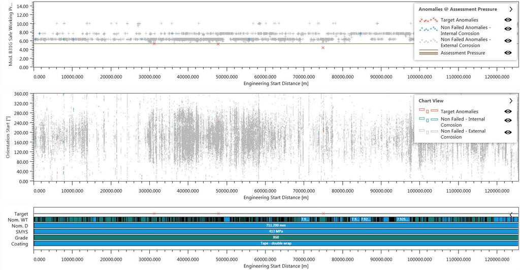
12 ILI Data alignment

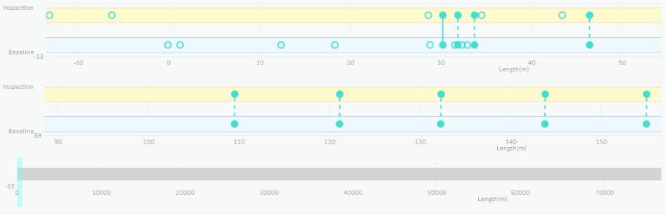

13 ILI Data alignment
14 Alignment and referencing Linear or Spatial? Re-alignment? Centerline accuracy? Maintaining changes Geocoding and interpolation of survey data? How can we be sure that the quality of the inspection data that goes into the system of record is (at least) maintained?
.")
15 Pipeline Referencing Core tables are managed by APR extension Use of calibration points to manage aligned data Time awareness provides the key to historical route management Multiple referencing systems (distance, etc). Work is ongoing

16 Data Models Legacy extensions to support APR are possible e.g. PODS Spatial flavours Decisions and data management strategy should look to the expected architectural changes around Enterprise GIS functionality Current choices are UPDM and PODS Lite, PODS v7 is still under development Regardless of the data model chosen, significant customizations are likely required to store all needed data, or links to legacy databases need to be engineered (and maintained)!

17 Title of the presentation Author Name ROSEN Group 20-Sep-2014 Slide 17
18 A Platform for Data Management and Analysis Analytics ETL External files
19 Key Take-aways Data management is a complex process, but one which has fundamental implications for the accuracy, availability and traceability of the data (and resulting calculations) throughout the enterprise Enterprise GIS are able to provide most if not all of the features required for the management of all kinds of integrity data, including time awareness and plug-and-play dashboards and apps As always there will be dynamics in the pure software market. Focus on the direct and future business needs and plan ahead!
20 Thank You! Questions and / or comments? o.huisman@rosen-group.com
PODS Lite. Technical Overview and Guide
 PODS Lite Technical Overview and Guide Introduction Since 1998, the Pipeline Open Data Standard (PODS) Association has been focused on providing a comprehensive, open, vendor-neutral, highly scalable,
Understanding ArcGIS Pipeline Referencing for Vertically Integrated Gas Companies. GeoConX 2017 September 7, 2017
 Understanding ArcGIS Pipeline Referencing for Vertically Integrated Gas Companies GeoConX 2017 September 7, 2017 The Asset Intelligence Imperative GOAL The necessity to learn ever more, in as close to
Leveraging SAP HANA and ArcGIS. Melissa Jarman Eugene Yang
 Melissa Jarman Eugene Yang Outline SAP HANA database ArcGIS Support for HANA Database access Sharing via Services Geodatabase support Demo SAP HANA In-memory database Support for both row and column store
PODS Lite version 1.1. Executive Summary
 PODS Lite version 1.1 Executive Summary Introduction Since 1998, the Pipeline Open Data Standard (PODS) Association has been focused on providing a comprehensive, open, vendor-neutral, highly scalable,
PODS Lite version 1.1. Technical Overview and Guide
 PODS Lite version 1.1 Technical Overview and Guide Introduction Since 1998, the Pipeline Open Data Standard (PODS) Association has been focused on providing a comprehensive, open, vendor-neutral, highly
Implementing PODS Next Gen (APR- Enabled) at Crestwood Midstream
 at Crestwood Midstream") Implementing PODS Next Gen (APR- Enabled) at Crestwood Midstream Petroleum GIS Conference 2018 May 10, 2018 Agenda Introduction to Crestwood Midstream Partners Asset Data Management in support of Asset
Implementing PODS Next Gen (APR- Enabled) at Crestwood Midstream Petroleum GIS Conference 2018 May 10, 2018 Agenda Introduction to Crestwood Midstream Partners Asset Data Management in support of Asset
PODS Lite. Executive Summary
 PODS Lite Executive Summary Introduction Since 1998, the Pipeline Open Data Standard (PODS) Association has been focused on providing a comprehensive, open, vendor-neutral, highly scalable, and proven
From Filing Cabinet to Integrity Management Resource Collecting Useful Data
 From Filing Cabinet to Integrity Management Resource Collecting Useful Data October 10, 2007 Scot Twining Product Manager GeoFields, Inc. EGUG 2007 1 Integrity Management - Collecting Useful Data Regardless
PODS Lite version 1.1. README List of Documents in PODS Lite Version 1.1 Package
 PODS Lite version 1.1 README List of Documents in PODS Lite Version 1.1 Package Introduction The twenty-four documents that comprise the PODS Lite version 1.1 download have been compressed into four ZIP
MEMORANDUM. From: Darlene Rouleau, Manager of Software Engineering and Sue Luczyk, Technical Support Lead. To: New Century Software Customers
 MEMORANDUM From: Darlene Rouleau, Manager of Software Engineering and Sue Luczyk, Technical Support Lead To: New Century Software Customers Date: 7 March 2016 Regarding: Support of Technology At New Century
Technology Advancements in Pipeline Data Management. Jeff Allen, Pipeline Practice Lead
 Technology Advancements in Pipeline Data Management Jeff Allen, Pipeline Practice Lead Common Patterns for Pipeline Organizations Mapping & Visualization Data Management Field Mobility Monitoring Analytics
PODS Association Update Lunchtime Webinar. January 11, 2018
 PODS Association Update Lunchtime Webinar January 11, 2018 Intro & Agenda PURPOSE: Making PODS useful and relevant Making the model process simpler, easier to use, and agile Notifying our members of what
Using ArcGIS for Server. Javier Abadía, Esri España Peter McDaid, Esri UK
 Using ArcGIS for Server Javier Abadía, Esri España Peter McDaid, Esri UK 1. Intro 2. ArcGIS for Server = Geospatial Apps Server 3. Map Services Publishing Flow Apps 4. Spatial Functionality Services Publishing
AGIC 2012 Workshop Leveraging Free RDBMS in ArcGIS
 AGIC 2012 Workshop Leveraging Free RDBMS in ArcGIS Prescott, AZ October 2012 Instructors: Bo Guo, PE, PhD Terry Li Workshop Outline Part I Introduction Why RDBMS Discussion on Obstacles for using RDBMS
Introduction to ArcSDE 8. John Calkins
 Introduction to ArcSDE 8 John Calkins Why are you here? Introduction to ArcSDE? What is a GeoDatabase? Existing SDE user? Existing ArcInfo user? Technical details on implementation? Just confused... ArcSDE
Training courses. Course Overview Details Audience Duration. Applying GIS
 Training courses (Last update: December 2017) Remarks: As part of a course a certificate is issued for each attendee. All software used during the courses is Open Source Software. Contact: allspatial Geospatial
ArcGIS for Server Michele Lundeen
 ArcGIS for Server 10.1 Michele Lundeen Summary Vision Installation and Configuration Architecture Publishing Functional Enhancements Cloud Migration and Best Practices Powerful GIS capabilities Delivered
Building an Enterprise GeoDatabase to Support a Service Oriented Architecture
 Dan Widner VDOT Dan.Widner@vdot.virginia.gov Paul Bucher Keane, Inc Paul.Bucher@vdot.virginia.gov Historical Perspective and Vision Technical Approach Historical Perspective and Vision A Bit of History
County of Los Angeles. Chief Information Office Preferred Technologies for Geographic Information Systems (GIS) Version 2 May 2015
 Version 2 May 2015") County of Los Angeles Chief Information Office Preferred Technologies for Geographic Information Systems (GIS) Version 2 May 2015 CIO Preferred Technologies for GIS This document lists the preferred Geographic
County of Los Angeles Chief Information Office Preferred Technologies for Geographic Information Systems (GIS) Version 2 May 2015 CIO Preferred Technologies for GIS This document lists the preferred Geographic
Introduction to Geodatabase and Spatial Management in ArcGIS. Craig Gillgrass Esri
 Introduction to Geodatabase and Spatial Management in ArcGIS Craig Gillgrass Esri Session Path The Geodatabase - What is it? - Why use it? - What types are there? - What can I do with it? Query Layers
Accessing and Administering your Enterprise Geodatabase through SQL and Python
 Accessing and Administering your Enterprise Geodatabase through SQL and Python Brent Pierce @brent_pierce Russell Brennan @russellbrennan hashtag: #sqlpy Assumptions Basic knowledge of SQL, Python and
Editing Versioned Geodatabases : An Introduction
 Esri International User Conference San Diego, California Technical Workshops July 24, 2012 Editing Versioned Geodatabases : An Introduction Cheryl Cleghorn Shawn Thorne Assumptions: Basic knowledge of
Intelligent Enterprise meets Science of Where. Anand Raisinghani Head Platform & Data Management SAP India 10 September, 2018
 Intelligent Enterprise meets Science of Where Anand Raisinghani Head Platform & Data Management SAP India 10 September, 2018 Value The Esri & SAP journey Customer Impact Innovation Track Record Customer
Open Source Software: What and Why?
 ESRI and Open Source A Love Story Presented by Bates Rambow Open Source Software: What and Why? What Software that has its source code published for anyone to inspect the source code. Generally released
THE CONCEPT OF. esilience MULTIDISCIPLINARY CENTER FOR EARTHQUAKE ENGINEERING RESEARCH
 THE CONCEPT OF 4 esilience 4 The Four Fundamental Properties of Resilience r r obustness esourcefulness r r edundancy apidity Enhancing resilience against multiple hazards using innovative spatial data
ArcGIS Enterprise: An Introduction. Philip Heede
 Enterprise: An Introduction Philip Heede Online Enterprise Hosted by Esri (SaaS) - Upgraded automatically (by Esri) - Esri controls SLA Core Web GIS functionality (Apps, visualization, smart mapping, analysis
Key Terms. Attribute join Target table Join table Spatial join
 Key Terms Attribute join Target table Join table Spatial join Lect 10A Building Geodatabase Create a new file geodatabase Map x,y data Convert shape files to geodatabase feature classes Spatial Data Formats
Understanding and Working with the OGC Geopackage. Keith Ryden Lance Shipman
 Understanding and Working with the OGC Geopackage Keith Ryden Lance Shipman Introduction - Introduction to Simple Features - What is the GeoPackage? - Esri Support - Looking ahead Geographic Things 3 Why
Learning What s New in ArcGIS 10.1 for Server: Administration
 Esri Mid-Atlantic User Conference December 11-12th, 2012 Baltimore, MD Learning What s New in ArcGIS 10.1 for Server: Administration Derek Law Product Manager Esri - Redlands ArcGIS for Server Delivering
The Oracle Enterprise Geodatabase (EGDB) Charlie Crocker Farallon Geographics, Inc.
 Charlie Crocker Farallon Geographics, Inc.") The Oracle Enterprise Geodatabase (EGDB) Charlie Crocker Farallon Geographics, Inc. www.fargeo.com Norcal URISA Chapter Meeting 2/9/2005 Todays Goals Enterprise geodatabase defined Roles Oracle can play
The Oracle Enterprise Geodatabase (EGDB) Charlie Crocker Farallon Geographics, Inc. www.fargeo.com Norcal URISA Chapter Meeting 2/9/2005 Todays Goals Enterprise geodatabase defined Roles Oracle can play
Working with Feature Layers. Russell Brennan Gary MacDougall
 Working with Feature Layers Russell Brennan Gary MacDougall Working with Feature Layers Session will focus on feature access and editing Highlight new features added over the last few releases Agenda Introduction
TRAINING GUIDE. Data Quality Tools for GIS and Lucity Spatial
 TRAINING GUIDE Data Quality Tools for GIS and Lucity Spatial Data Quality Tools for GIS and Lucity Spatial In this session, we ll cover the tools that can be used to ensure your GIS data is clean in regards
Administering Your Oracle Geodatabase. Amit Kesarwani Mandar Purohit
 Administering Your Oracle Geodatabase Amit Kesarwani Mandar Purohit Intended Audience Desktop Web Device You are.. - A geodatabase administrator - An accidental DBA - A deliberate DBA Portal Portal Server
Assimilating GIS-Based Voter Districting Processes in Maricopa County, Arizona
 Assimilating GIS-Based Voter Districting Processes in Maricopa County, Arizona Tim Johnson Geographic Information Systems Manager Maricopa County Recorder/Elections Department Abstract Accurate district
Using Mobile LiDAR To Efficiently Collect Roadway Asset and Condition Data. Pierre-Paul Grondin, B.Sc. Surveying
 Using Mobile LiDAR To Efficiently Collect Roadway Asset and Condition Data Pierre-Paul Grondin, B.Sc. Surveying LIDAR (Light Detection and Ranging) The prevalent method to determine distance to an object
Server AMS/PLL 2014 SP1 for ArcGIS 10.0 SP5 Update Guide
 Server AMS/PLL 2014 SP1 for ArcGIS 10.0 SP5 Update Guide By Azteca Systems Inc. COPYRIGHT INFORMATION Copyright 2014 by Azteca Systems Inc. All rights reserved. Azteca Systems Inc. 11075 S. State St.,
Marushka Server. Product Specification
 Introductory Information Product Marushka Server represents a new generation of tools (devices) for publication and use of GIS data in the Internet and intranet. It is built on component technology in.net
On-Demand Setup Guide V 1.0
 On-Demand Setup Guide V 1.0 Contents 1. What is Teranet Xchange?... 3 2. How does it work?... 3 3. Teranet Xchange enhanced security features... 5 4. How do I get started?... 6 5. Frequently Asked Questions...
May 2013 Oracle Spatial and Graph User Conference
 May 2013 Oracle Spatial and Graph User Conference May 22, 2013 Ronald Reagan Building and International Trade Center Washington, DC USA Paul Calhoun & Vince Smith GIS Systems Analyst City Of Virginia Beach
Collector for ArcGIS Preparing for and Working in a disconnected environment
 Collector for ArcGIS Preparing for and Working in a disconnected environment Peter Nasuti, Dan Moore, Nicholas Davis Topics Covered With demonstrations throughout each step 1) What is Collector? What can
Does Your Data Have Harmony. Dan Stone
 Does Your Data Have Harmony Dan Stone Agenda Introduction Configuration Patterns Implementation Approaches Your Feedback ArcGIS for Local Government Esri solutions for local government customers Series
Administering Your Oracle Geodatabase. Jim McAbee Mandar Purohit
 Administering Your Oracle Geodatabase Jim McAbee Mandar Purohit Intended Audience Desktop Web Device You are.. - A geodatabase administrator - An accidental DBA - A deliberate DBA - Not sure what DBA means
Server AMS/PLL 2014 SP1 for ArcGIS 10.1 SP1 & 10.2.x Update Guide
 Server AMS/PLL 2014 SP1 for ArcGIS 10.1 SP1 & 10.2.x Update Guide By Azteca Systems Inc. COPYRIGHT INFORMATION Copyright 2014 by Azteca Systems Inc. All rights reserved. Azteca Systems Inc. 11075 S. State
Collector for ArcGIS. Paul Barker Bert Yagrich
 Collector for ArcGIS Paul Barker Bert Yagrich Agenda What are we going to cover today? ArcGIS as a platform for data collection Device strategy and field data collection Collector for ArcGIS an overview
Server AMS/PLL 2014 SP1 for ArcGIS 10.1 SP1 & 10.2.x Install Guide
 Server AMS/PLL 2014 SP1 for ArcGIS 10.1 SP1 & 10.2.x Install Guide By Azteca Systems Inc. COPYRIGHT INFORMATION Copyright 2014 by Azteca Systems Inc. All rights reserved. Azteca Systems Inc. 11075 S. State
Integrating Spatial Data with the rest of your E&P Data
 Integrating Spatial Data with the rest of your E&P Data ESRI PUG Houston 11-March-2003 Ian Batty PPDM Association 1 PPDM Association Public Petroleum Data Model Association The PPDM Association is a non-profit
PostgreSQL/PostGIS: Introduction
 PostgreSQL/PostGIS: Introduction Introduction PostgreSQL A standards-compliant SQL-based database server with which a wide variety of client applications can communicate Server software generally, but
Get a Second Opinion: Enterprise GIS Health Checks. David Crosby Esri Southeast Regional Professional Services Charlotte, NC
 Get a Second Opinion: Enterprise GIS Health Checks David Crosby Esri Southeast Regional Professional Services Charlotte, NC E M E R A L D S A P P H I R E T H A N K Y O U T O O UR SPONSORS What is an Enterprise
Stir It Up: Achieving GIS Interoperability
 Stir It Up: Achieving GIS Interoperability City of Tacoma, Washington, USA Mike Murnane, Community & Economic Development John Shell, Public Works 2006 ESRI International User Conference - August 9, 8:30
Understanding and Using Metadata in ArcGIS. Adam Martin Marten Hogeweg Aleta Vienneau
 Understanding and Using Metadata in ArcGIS Adam Martin Marten Hogeweg Aleta Vienneau Adam Martin National Government Account Management R&D Open Data Marten Hogeweg National Government Professional Services
ArcSDE architecture and connections
 ArcSDE architecture and connections Lesson overview ArcSDE system components Application Server Connections Direct Connect Geodatabase properties ArcSDE versions What is a version ArcIMS and versions 6-2
IBM Security Guardium Analyzer
 IBM Guardium Analyzer Highlights Assess security & compliance risk associated with GDPR data Find GDPR data across onpremises and cloud databases Scan for database vulnerabilities Leverage next-generation
Regarding the quality attributes, the architecture of the system must be:
 The SDSS System Overview This chapter gives an overview of the software architecture of the RiskChanges SDSS system. One of the objectives within the project is the development of a SDSS system for probabilistic
Maps for Spatial Data Infrastructures (Service-Oriented Web Mapping)
") Maps for Spatial Data Infrastructures (Service-Oriented Web Mapping) Ionuț Iosifescu 1 Spatial Data Infrastructures?!? Image courtesy of INSPIRE 2 Image courtesy of swisstopo 3 Spatial Data Infrastructures
Maps for Spatial Data Infrastructures (Service-Oriented Web Mapping) Ionuț Iosifescu 1 Spatial Data Infrastructures?!? Image courtesy of INSPIRE 2 Image courtesy of swisstopo 3 Spatial Data Infrastructures
GEOSPATIAL ENGINEERING COMPETENCIES. Geographic Information Science
 GEOSPATIAL ENGINEERING COMPETENCIES Geographic Information Science The character and structure of spatial information, its methods of capture, organisation, classification, qualification, analysis, management,
Pre-Incident Planning ( PIP )
") Pre-Incident Planning ( PIP ) Presentation Overview 1) Web GIS Terminology Review 2) Technical Details of PIP 3) The Start of PIP 4) PIP & General Maintenance Currently 1 year old Dashboards & Python 5)
Pre-Incident Planning ( PIP ) Presentation Overview 1) Web GIS Terminology Review 2) Technical Details of PIP 3) The Start of PIP 4) PIP & General Maintenance Currently 1 year old Dashboards & Python 5)
Understanding and using Metadata across the ArcGIS Platform. Aleta Vienneau Marten Hogeweg
 Understanding and using Metadata across the ArcGIS Platform Aleta Vienneau Marten Hogeweg Understanding and using Metadata across the ArcGIS Platform Metadata fundamentals ArcGIS platform Road ahead Metadata
Tracking and defending changes in an ESRI Geodatabase
 Tracking and defending changes in an ESRI Geodatabase 2017 ESRI Petroleum User Group (PUG) Conference Jeff Wilcox Kinder Morgan Peter Veenstra - TRC Introduction and Overview Introductions Jeff Wilcox
Beyond PostGIS. New developments in Open Source Spatial Databases. Karsten Vennemann. Seattle
 New developments in Open Source Spatial Databases Karsten Vennemann Seattle Talk Overview Intro Relational Databases PostGIS JASPA INGRES Geospatial MySQL Spatial Support HatBox a user space extension
THIS SLIDE NOT PART OF PRESENTATION.
 THIS SLIDE NOT PART OF PRESENTATION. Abstract: The Ohio Department of Transportation initiated the Roadway Information Management System (RIMS) as a multiphase project to upgrade the architecture, software,
ArcGIS Runtime SDKs: Building a Routing Application. Frank Kish Konstantin Kutsner
 ArcGIS Runtime SDKs: Building a Routing Application Frank Kish Konstantin Kutsner Overview What goes into a routing application Data connected \ disconnected Demo creating mmpk API Demo code Other Resources
Design a Geodatabase. Rasu Muthurakku, Enterprise Solutions Architect / Consultant
 Rasu Muthurakku, Enterprise Solutions Architect / Consultant Agenda Overview Key Factors Design - Recommendations Key Considerations, Best Practices and Recommendations / Lessons Learned! Overview What
An Introduction to GIS for developers
 An Introduction to GIS for developers Part 4: GIS Sharing Canserina Kurnia & Tom Shippee Agenda Web GIS ArcGIS Online Cloud-based ArcGIS Server ArcGIS Server on-premises ArcGIS a complete platform discover,
Brandenburg 3D a comprehensive 3D subsurface model, conception of an infrastructure node and a web application
 Brandenburg 3D a comprehensive 3D subsurface model, conception of an infrastructure node and a web application Maik Schilling 1, Andreas Simon 1, Christoph Jahnke 1, Thomas Höding 1 1 Landesamt für Bergbau,
System Design and Tuning
 System Design and Tuning Lucity 2018 R2 Overview Lucity Specifications 2018 R2 Web Identity Server Document Server File Server Database Server Service Server Citizen Portal Mobile Server Android Devices
Dynamic Situational Awareness. Through Developer Applications
 Dynamic Situational Awareness Through Developer Applications Mission Focused Applications Building Apps to support operations Agile Simple High-Performance Defense Developers GIS Simplifies Working With
Editing In Arcgis Desktop 10 Manual READ ONLINE
 Editing In Arcgis Desktop 10 Manual READ ONLINE Feature Service Editing using ArcGIS Desktop - Feature Service Editing using ArcGIS Desktop. In this video, ArcGIS Server product manager Ismael Chivite
SkylineGlobe 6.5 s New Developments
 SkylineGlobe 6.5 s New Developments The SkylineGlobe Enterprise suite of applications was created to provide all of the necessary software tools for an organization to implement their own private, 3D virtual
Collector for ArcGIS: What s New. Chris LeSueur & James Tedrick
 Collector for ArcGIS: What s New Chris LeSueur & James Tedrick Outline Product overview Workflows Preparing data for Collector for ArcGIS What s new in Collector for ArcGIS v18.1.0 (Aurora) Advanced topics
CRIS - The New York State Cultural Resource Information System
 CRIS - The New York State Cultural Resource Information System Larry Spraker Fountains Spatial Michael Schifferli NY State Historic Preservation Office NYS SHPO Mission The NYS State Historic Preservation
Land Information Management and its (3D) Database Foundation
 Database Foundation") Land Information Management and its (3D) Database Foundation Han Wammes, Oracle Netherlands November 18 th, 2011 1 Copyright 2011, Oracle and/or its affiliates. All rights Safe Harbor Statement The following
Land Information Management and its (3D) Database Foundation Han Wammes, Oracle Netherlands November 18 th, 2011 1 Copyright 2011, Oracle and/or its affiliates. All rights Safe Harbor Statement The following
Sharing Web Layers and Services in the ArcGIS Platform. Melanie Summers and Ty Fitzpatrick
 Sharing Web Layers and Services in the Platform Melanie Summers and Ty Fitzpatrick Agenda Platform overview - Web GIS information model - Two deployment options Pro Sharing - User experience and workflows
Asset Management for CSDS and BMP Infrastructure
 Asset Management for CSDS and BMP Infrastructure Ramzi K. Bannura GISP, MBA GeoSpatial Programs Manager Bureau of Highways Anne Arundel County Maryland 2662 Riva Road; Suite 123 Annapolis, MD 21401 (410)222-4163
Advanced Parcel Editing. Amy Andis Tim Hodson
 Advanced Parcel Editing Amy Andis Tim Hodson Overview What to expect in this technical workshop Review of the Parcel Fabric Data Model Advanced Tips and tricks for Parcel entry Assessing Quality of Parcel
APPLICATIONS MANAGEMENT ASG-SMARTTEST FOR INTERACTIVE APPLICATION TESTING AND DEBUGGING
 APPLICATIONS MANAGEMENT ASG-SMARTTEST FOR INTERACTIVE APPLICATION TESTING AND DEBUGGING ASG-SMARTTEST OVERVIEW ASG-SmartTest provides language intelligence with automated testing and debugging facilities
Georeferencing. Georeferencing: = linking a layer or dataset with spatial coordinates. Registration: = lining up layers with each other
 Georeferencing How do we make sure all our data layers line up? Georeferencing: = linking a layer or dataset with spatial coordinates Registration: = lining up layers with each other Rectification: The
DOC // ARC GIS QUERY BUILDER LIST DOWNLOAD
 16 April, 2018 DOC // ARC GIS QUERY BUILDER LIST DOWNLOAD Document Filetype: PDF 505.64 KB 0 DOC // ARC GIS QUERY BUILDER LIST DOWNLOAD NET 3D 3D GIS Android Announcement ArcGIS 10 ArcGIS. Using Wildcards
Data Interoperability An Introduction
 2013 Esri International User Conference July 8 12, 2013 San Diego, California Technical Workshop Data Interoperability An Introduction Bruce Harold Esri Dale Lutz Safe Software Background Why Data Interoperability?
August Oracle - GoldenGate Statement of Direction
 August 2015 Oracle - GoldenGate Statement of Direction Disclaimer This document in any form, software or printed matter, contains proprietary information that is the exclusive property of Oracle. Your
ArcGIS Server Architecture Considerations. Andrew Sakowicz
 ArcGIS Server Architecture Considerations Andrew Sakowicz Introduction Andrew Sakowicz - Esri Professional Services - asakowicz@esri.com 2 Audience Audience - System Architects - Project Managers - Developers
FDO Data Access Technology at a Glance
 Autodesk Geospatial FDO Data Access Technology at a Glance Work seamlessly with your geospatial data whatever the format 1 The Challenge The growing need for openness and interoperability between traditional
Planning for Your Professional GIS Development: Esri Technical. Renee Schreibman Regional Training Consultant
 Planning for Your Professional GIS Development: Esri Technical Certification Renee Schreibman Regional Training Consultant Session Overview Benefits of Training Budgeting/Purchasing Training Delivery Methods
April Oracle Spatial User Conference
 April 29, 2010 Hyatt Regency Phoenix Phoenix, Arizona USA Parag Parikh Dan Kuklov CURRENT Group Kerry D. McBee Xcel Energy Unified Real-Time Network Topology Management Using Xcel Energy SmartGridCity
Standardized Data Production Strategies Across Your Enterprise
 Federal GIS Conference February 9 10, 2015 Washington, DC Standardized Data Production Strategies Across Your Enterprise Amber Bethell Sherry Fagin Authoritative content producers Knowledge Workers Executive
Building Applications with the ArcGIS Runtime SDK for WPF
 Esri International User Conference San Diego, California Technical Workshops 24 th July 2012 Building Applications with the ArcGIS Runtime SDK for WPF Euan Cameron & Paul Pilkington Agenda Introduction
Subject: Migration Information for ArcIMS, ArcSDE, and ArcGIS Server Users
 December 12, 2006 Subject: Migration Information for ArcIMS, ArcSDE, and ArcGIS Server Users Summary This document provides information about how we are migrating your licenses and maintenance for ESRI
Change Management for the ArcGIS Platform for Local Government. Ayan Mitra Seth Lewis
 Change Management for the ArcGIS Platform for Local Government Ayan Mitra Seth Lewis What is Change Management? Process used to ensure that changes to a product or system are introduced in a controlled
ENGRG 59910: Introduction to GIS
 ENGRG 59910: Introduction to GIS Lecture 05: GIS and Databases Basics Acknowledgment: Michael Piasecki Where are we now? Basic geographic concepts Introduction to GIS, coordinate system, projection, datum
ArcGIS GeoEvent Server: Real-Time GIS
 ArcGIS GeoEvent Server: Real-Time GIS Anthony Myers Local Government Solutions Engineer Kevin Armstrong Public Safety Solutions Engineer E M E R A L D S A P P H I R E T H A N K Y O U T O O UR SPONSORS
Assessing the Value of an Integrated GIS Seismic Management System
 March 8, 2005 Author: Scott McCulloch Assessing the Value of an Integrated GIS Seismic Management System TGS-NOPEC Geophysical Company Abstract TGS seismic order entry system is an enterprise-level database
Introduction to the Dimensionally Extended 9 Intersection Model (DE-9IM) in PostgreSQL/PostGIS Tutorial
 in PostgreSQL/PostGIS Tutorial") Introduction to the Dimensionally Extended 9 Intersection Model (DE-9IM) in PostgreSQL/PostGIS Tutorial Germán Carrillo gcarrillo@uni-muenster.de geotux_tuxman@linuxmail.org Objectives Following this tutorial
Introduction to the Dimensionally Extended 9 Intersection Model (DE-9IM) in PostgreSQL/PostGIS Tutorial Germán Carrillo gcarrillo@uni-muenster.de geotux_tuxman@linuxmail.org Objectives Following this tutorial
An interoperable platform. rencontres mondiales du logiciel libre - july 12th, 2007
 1 An interoperable platform rencontres mondiales du logiciel libre - july 12th, 2007 Content 2 COGIT Towards a new platform: GeOxygene COGIT experience about platforms and common GIS problems Architecture
USING WEB APPBUILDER TO TRACK TEMPORARY WATER METER DEPLOYMENTS. Olivia DeSimone, GISP GIS Analyst City of Altamonte Springs
 USING WEB APPBUILDER TO TRACK TEMPORARY WATER METER DEPLOYMENTS Olivia DeSimone, GISP GIS Analyst City of Altamonte Springs CITY OF ALTAMONTE SPRINGS Located in Seminole County (Central Florida) Seminole
May 22, 2013 Ronald Reagan Building and International Trade Center Washington, DC USA
 May 22, 2013 Ronald Reagan Building and International Trade Center Washington, DC USA Scott Gooding Spatial Database Architect CSX Rail: Implementation of Oracle s Spatial Routing, Geocoding, LRS and NDM
InCLUDE Data Exchange. Julia Harrell, GISP GIS Coordinator, NC DENR
 InCLUDE Data Exchange Julia Harrell, GISP GIS Coordinator, NC DENR Julia.harrell@ncdenr.gov InCLUDE Project Partners NC Department of Environment & Natural Resources: The State of NC s lead environmental
SOFTWARE PRODUCT. GEOINFORMATION SYSTEM «PANORAMA» (GIS Panorama) Applied tasks. Import and export data of format ArcSDE to DB Oracle
 Applied tasks. Import and export data of format ArcSDE to DB Oracle") APPROVED -AS Orig. Inv. No. Signature and date Repl. inv. No. Copy inv. No. Signature and date SOFTWARE PRODUCT GEOINFORMATION SYSTEM «PANORAMA» (GIS Panorama) Applied tasks. Import and export data of
APPROVED -AS Orig. Inv. No. Signature and date Repl. inv. No. Copy inv. No. Signature and date SOFTWARE PRODUCT GEOINFORMATION SYSTEM «PANORAMA» (GIS Panorama) Applied tasks. Import and export data of
MicroStation. FDO Reader USER S MANUAL. [Företagets adress]
![MicroStation. FDO Reader USER S MANUAL. [Företagets adress]](/thumbs/93/111326866.jpg "MicroStation. FDO Reader USER S MANUAL. [Företagets adress]") MicroStation FDO Reader USER S MANUAL [Företagets adress] MicroStation FDO Reader - User s Manual, 2018-10-27 copyright, 2018 ringduvevägen 13, 132 47 saltsjö-boo e-mail: consulting@surell.se, web: www.surell.se
MicroStation FDO Reader USER S MANUAL [Företagets adress] MicroStation FDO Reader - User s Manual, 2018-10-27 copyright, 2018 ringduvevägen 13, 132 47 saltsjö-boo e-mail: consulting@surell.se, web: www.surell.se
Spatially Enable Your DBA PUG Miles Phillips LandWorks, Inc Feb 27, 2008
 Spatially Enable Your DBA PUG 2008 Miles Phillips mphillips@landworks.com LandWorks, Inc Feb 27, 2008 Audience Experienced DBAs assigned to support ArcSDE Experienced ArcGIS users that need to understand
AutoCAD Map 3D and ESRI ArcSDE
 AUTOCAD MAP 3D 2009 WHITE PAPER AutoCAD Map 3D and ESRI ArcSDE Many organizations, such as utilities, telecommunication providers, and government agencies, depend on geospatial data that is stored in a
Lily: A Geo-Enhanced Library for Location Intelligence
 Lily: A Geo-Enhanced Library for Location Intelligence 15th International Conference on Data Warehousing and Knowledge Discovery (DaWaK'13) August 26, 2013 Matteo Golfarelli Stefano Rizzi Marco Mantovani