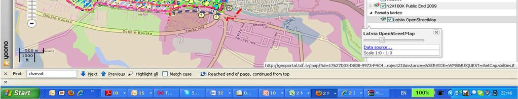
Social Validation of INSPIRE Annex III Data Structures in EU Habitats (27th of June 16:00 room Fintry) Karel Charvat Help Service Remote Sensing
|
|
|
- Grant Michael Powers
- 6 years ago
- Views:
Transcription
 Karel Charvat Help Service Remote")
1 Social Validation of INSPIRE Annex III Data Structures in EU Habitats (27th of June 16:00 room Fintry) Karel Charvat Help Service Remote Sensing
2 Content Lessons learn from user communities Why harmonize data? For whom are metadata important From INSPIRE to Habitats Architecture Reference laboratory as prove of concept Pilots testbeds
3 Lessons learn from user communities NATURAL RESOURCE MGMT ECO- TOURISM WILD SALMON MONITORING LA PALMA MARINE RESERVE NAT L POLICY HIKING TRIP PLANNER CZECH NAT L FOREST PROGRAMME SORIA NATURAL RESERVE SHEEP & GOAT HERD MANAGEMENT ECON ACTIVITY AT COASTAL BENTHIC HAB. ECONOMIC ACTIVITIES
4 Lessons learn from user communities Analysis of use cases Generalization How communities request could influence architecture design, data models and metadata requirements
5 Analysis of use cases Use case 1 Actors Task Sheep and Goat Herding Management Personnel at Madonie Park Authority This is mostly an internal but fundamental task at Madonie Park Authority the requires the availability of geospatial data inside the whole Office and for external consultants (mainly researchers) that must help internal staff in managing the areas of the park. All this people access data by their GIS software or the WEBGIS platform, through geospatial web services INSPIRE compliant. Assumptions The proprietary databases can be made INSPIRE-compliant using the HABITATS Metadata profile in order to be accessed through the Sicily Region Portal using GIS or WEBGIS software compliant to OGC web services. Description Comments People at Madonie Park Authority deal with the management of grazing areas in a sustainable way allowing shepherds to access to areas, assigned to each of them, for grazing of sheep and goats. The control of the impact of grazing on assigned areas is carried out by Park Authority Personnel and external experts. This requires also the production of new layers on the state of areas the must be in a format compliant to ISPIRE directive in order to be used in an appropriate way. Data used for this task are: - Grazing plan; - Animals position distributed over the whole period of grazing; - State of conservation of areas (this includes some information such as level of pressure caused by animals).
6 Analysis of use cases Use case Actors Task Wild Salmon Monitoring and Management Internationally Researchers, and Decision Makers The International SALSEA Group through collaboration in the FP7 SALSEA-Merge project is investigating and recording in 2 major databases, the migration and distribution of salmon in the North-East Atlantic. The Use Case is to make their extensive data open and accessible using INSPIRE principles. Based on their existing best-practice, this group is likely to impact on the proposed salmonrelated data, metadata and services that will be input to the INSPIRE TWGs. Assumptions As the SALSEA Group wish to focus all of their efforts on their scientific work until the end of the SALSEA Merge project, it will be late 2011 before they will allow their data to be made available to a HABITATS pilot. They also wish to see how the Irish National pilot gets on and reuse its learning and approach. Description Comments This group uses the widely used best-practice ICES WGNAPES database structure. WGNAPES is a permanent Group that will continue after the SALSEA-Merge project ends in ICES/WGNAPES is an Internal database composed of National databases. With some fields added for SALSEA-Merge and the Genetic database. So it is good practice and a permanent working group which should lead to very useful inputs to the 4 HABITATS INSPIRE themes. This case with SALSEA-Merge is complex, and touches on the potentially high commercial value of the genetic databases, which is the reason for the reticence of the scientists involved in opening up their information to be INSPIRE compliant. On the other hand, interfacing INSPIRE-compliant databases with commercial services might be the most effective means for them to profit from their research. These issues will be further explored when MAC is able to more actively engage with the SALSEA-Merge stakeholders, after their current project work ends.
7 Analysis of use cases Use case Actors Task Subsidies in the forest management forest owners, state and regional forest administration, EU public Every time the forest owner decides to apply for one, or more of the subsidy programmes in forestry, he needs to prepare project of the desired action. The digital datasets of the Regional Plans of Forest Development (RPFD) can be used to plan the reforestation of the target tree species in respect with their natural conditions, to manage the decision process in case of windthrow event, to build the shelter, or the new biking trail, etc. Assumptions RPFD digital forest maps: - Typological map 1: Map of forest altitudinal zones 1: Map of forest target management sets 1: Map of long-term forest protection measures 1: Map of declared functions 1: Map of function potential 1: Transportation map 1: Description In the Czech forest law, there are several means of promotion the sustainable forest management. The government provides subsidies for reforestation and plantations of native forest species, to support the wood production after natural disasters (bark beetle, windthrow events) and gentle management practices. Further there are subsidies to promote rural development and recreational function of forests (afforestation of agricultural land, building of biking trails and other tourist infrastructure, and more.) The information from the Regional Plans of Forest Development (RPFD) datasets serve as a basis the decision-making, project preparation, and finally also controls of the subsidies usage. Comments
8 Analysis of use cases data usage Regional data used regionally Global data used regionally Regional data used cross regionally Regional data used globally Global data used globally
9 Regional data used regionally There is not direct requirement for INSPIRE data models Local data models could be wider Local data models reflect regional needs and also regional decision processes If data are not shared outside of region (but in many cases it is necessary), in principle global standards are not needed Standards are needed in case of more data suppliers, to guarantee data consistence


10 Regional data used regionally
11 Global data used regionally Global data are in some content something like de facto standards In some cases it is necessary to be possible transform data into such models, which is required by regional decision processes The global model has to cover regional decision needs (GMES case for example) Question is, if this transformation will be done on fly or offline Language problem


12 Example FMI data used locally
13 Example FMI data used locally
14 Regional data used cross regionally There is already very visible problem of data harmonization, this problem is higher, in the case of cross boarder regions In many cases, like tourism we need deal not with one or more separate data theme, but with complex mixture of themes related to INSPIRE In some application cases model could be broader then INSPIRE definition Language problem

15 Tourist example
16 Regional data used globally Probably most relevant cases for INSPIRE data model The idea is to combine local data sets into one data set The regional data has to be transformed (in many cases simplified) into global model Relevant cases are tourism, transport, education, research, environment protection, risk management, strategic decision Language problem

17 Regional data used globally

18 Regional data used globally
19 Global data used globally Global data are standard or de facto standard. It is expected, that in the case of data of public sector, this data will be already in INSPIRE models It could happened, that this models has to be transformed on the base of needs of concrete application area. Transformation could be based also on Feature Encoding or SLD.


20 Global data used globally
21 Global data used globally

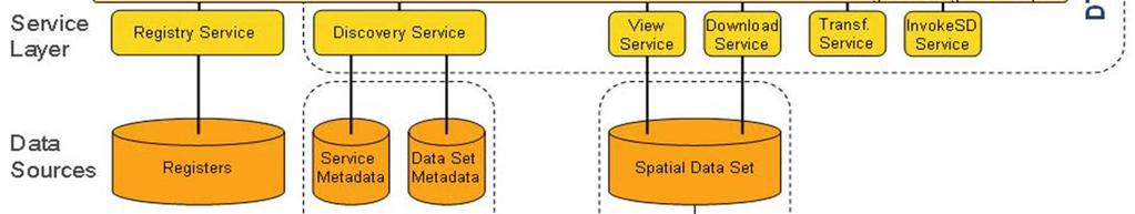
22 Sea Regions Bio-geographical regions Habitats and biotopes Species distribution D3.1 Conceptual Data Models UML Class Diagrams Feature Catalogues INSPIRE TWGs methodology used for INSPIRE data specification, international standards As simple as possible Just common elements and attributes To enable an extension of models To interconnect Habitats themes To re-use existing componets TRAGSATEC analyses of data models for selected themes used in single countries participating on Habitats project results of previous tasks of Habitats project TU Graz HSRS INSPIRE testing IMCS
23 INSPIRE Data Specifications 2.0 FMI data Harmonization Testing of specifications (based on Habitats data models and user requirements) Sea Regions Bio-geographical regions Habitats and biotopes Species distribution


 FMI")
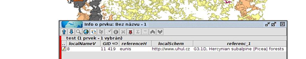
24 Source data Vegetation tiers (altitudinal vegetation zones) layer Part of PFD (Regional Plans of Forest Development) produced by FMI Spatial reference system - SJTSK (Czech national system) FMI original classification system
25 New Data Model Existing data model + referencehabitattypeid: CharacterString referencehabitattypescheme: ReferenceHabitatTypeSchemeValue localschemeuri: URI localnamevalue: CharacterString geometry: polygon referencehabitattypeid: eunis_value referencehabitattypescheme: eunis localschemeuri: link_to_fmi_classification localnamevalue: FMI_classification_value


26 Harmonization process Open SHP file and its scheme New data model Save final SHP file Reclassification FMI EUNIS
27 Taxonomy reclassification (FMI Eunis) 0 Pine G3.42,"4","Middle European [Pinus sylvestris] forests" 1 Oak G1.87,"4","Medio-European acidophilous [Quercus] forests" 2 Beech-oak G1.82,"4","Atlantic acidophilous [Fagus] - [Quercus] forests" 3 Oak-beech G1.82,"4","Atlantic acidophilous [Fagus] - [Quercus] forests" 4 Beech G1.6,"3","[Fagus] woodland" 5 Fir-beech G4.6,"3","Mixed [Abies] - [Picea] - [Fagus] woodland" 6 Spruce-beech G4.6,"3","Mixed [Abies] - [Picea] - [Fagus] woodland" 7 Beech-spruce G4.6,"3","Mixed [Abies] - [Picea] - [Fagus] woodland" 8 Spruce G3.1D,"4","Hercynian subalpine [Picea] forests" 9 Dwarp pine F2.45,"4","Hercynian [Pinus mugo] scrub"


28 Target data Source data (simplified)
29 Metadata profiles and cataloging Requirements on metadata information are growing with professionalism of users. Simply we can say, that for example tourist requirements will be done usually by theme of information and spatial or eventually time extend Requirements of specialist could lead to extension of current INSPIRE standards (done as part of Habitats work)


30 Simple metadata inside of viewer

31 Habitats multi search


32 INSPIRE versus Habitats architecture
33 What is missing from Habitats view INSPIRE architecture doesn t reflect needs of regions about data collection and updating INSPIRE architecture doesn t reflect needs of regions about metadata collection and updating In single Habitats pilot cases you don t need necessary full architecture Components of Habitats architecture could be localized on more places.
34 Example Metadata Habitats metadata management has to be divided into single components, guarantee communication using CSW standards. So metadata management system could run on different server, than single clients Metadata management system is divided from metadata edition and also from discovery services.
35 Example Metadata Catalogue system is now composed from independent components: Metadata catalogue Metadata editor client Metadata import client Metadata harvesting client Metadata valuator client Light discovery services client Full discovery services client
36 Example Metadata Currently solved problem is about metadata management, if to use metadata harvesting or provide multi search to multiple catalogue Second option could be combined with some methods of metadata caching The problems are with different usage of standards in INSPIRE and ISO, for example some GEOSS catalogues are not compatible with INSPIRE based catalogues
37 View services Current most popular technologies are based on clients technologies. It give us some advantage, but also could bring problems with browsers and some operations like coordinate transformation or printing Server part of client is necessary

38 View services

39 View services
40 Additional services required Sensor Observation Services Data uploading Data composition forming Vectorisation of data Data download Support for mobile online and offline data collection Support for iframe or portlets to be possible integrate components with Web pages


41 Usage of iframe
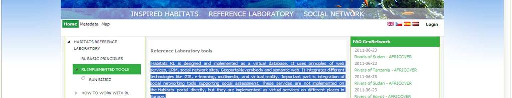
42 Reference laboratory Habitats RL is designed and implemented as a virtual database. It integrates different technologies like GIS, multimedia, and virtual reality. Important part is integration of social networking tools supporting social assessment. These services are not implemented on the Habitats portal directly, but they are implemented as virtual services on different places in Europe.

43 Reference laboratory
44 Pilot implementation Not all pilots need to implement full architecture, subset of architecture is given by pilot needs Pilot implementation are based on common generic architecture principles, but they are free to use different components and platforms, this give possibilities for good testing of interoperability Pilot applications are validate by users, but also against RL
45 Thank you for your attention Karel Charvat Help Service Remote Sensing
Introduction to INSPIRE. Network Services
 Introduction to INSPIRE. Network Services European Commission Joint Research Centre Institute for Environment and Sustainability Digital Earth and Reference Data Unit www.jrc.ec.europa.eu Serving society
GeoPortal 4 Everybody
 GeoPortal 4 Everybody Karel Charvát, Jáchym Čepický, Štěpán Kafka, Premysl Vohnout, Martin Vlk Czech Centre for Science and Society Help Service Remote Sensing DT Member What is GeoPortal GeoPortal is
INSPIRE & Environment Data in the EU
 INSPIRE & Environment Data in the EU Andrea Perego Research Data infrastructures for Environmental related Societal Challenges Workshop @ pre-rda P6 Workshops, Paris 22 September 2015 INSPIRE in a nutshell
EarthLookCZ as Czech way to GMES
 EarthLookCZ as Czech way to GMES Karel Charvat 1 and Petr Horak 1 1 WirelessInfo, Czech Republic, charvat@wirelessinfo.cz Abstract Global Monitoring for Environment and Security is one of 4 ranges of solutions
INSPIRE overview and possible applications for IED and E-PRTR e- Reporting Alexander Kotsev
 INSPIRE overview and possible applications for IED and E-PRTR e- Reporting Alexander Kotsev www.jrc.ec.europa.eu Serving society Stimulating innovation Supporting legislation The European data puzzle 24
HUMBOLDT Application Scenario: Protected Areas
 CC by Erlend Schei Copyright by Kecko Copyright by Michael Bezzina CC by Gunnar Ries Copyright by Michael Bezzina Copyright by Michael Bezzina Copyright by Michael Bezzina CC by fs999 CC by Jordan Nielsen
INSPIRE in a nutshell, and overview of the European Union Location Framework
 INSPIRE in a nutshell, and overview of the European Union Location Framework Francesco Pignatelli European Commission, DG JRC 10 th European Congress and Exhibition on Intelligent Transport Systems and
The European Commission s science and knowledge service. Joint Research Centre
 The European Commission s science and knowledge service Joint Research Centre GeoDCAT-AP The story so far Andrea Perego, Antonio Rotundo, Lieven Raes GeoDCAT-AP Webinar 6 June 2018 What is GeoDCAT-AP Geospatial
CREATING SMART TRANSPORT SERVICES BY FACILITATING THE RE-USE OF OPEN GIS DATA
 OPEN TRANSPORT NET TOMAS MILDORF 16 JUNE 2014 INSPIRE CONFERENCE 2014, AALBORG, DENMARK CREATING SMART TRANSPORT SERVICES BY FACILITATING THE RE-USE OF OPEN GIS DATA 2 1 OTN AT A GLANCE Full title OpenTransportNet
GeoDCAT-AP Representing geographic metadata by using the "DCAT application profile for data portals in Europe"
 GeoDCAT-AP Representing geographic metadata by using the "DCAT application profile for data portals in Europe" Andrea Perego, Vlado Cetl, Anders Friis-Christensen, Michael Lutz, Lorena Hernandez Joint
Enabling Efficient Discovery of and Access to Spatial Data Services. CHARVAT, Karel, et al. Abstract
 Article Enabling Efficient Discovery of and Access to Spatial Data Services CHARVAT, Karel, et al. Abstract Spatial data represent valuable information and a basis for decision making processes in society.
SEIS. (Shared Environmental Information System) From concept to information services
 From concept to information services") SEIS (Shared Environmental Information System) From concept to information services Stefan Jensen EEA supported by Sheila Cryan and Jon Maidens GSDI 11, Rotterdam 19.6.2009 What is SEIS is about... Sharing
SEIS (Shared Environmental Information System) From concept to information services Stefan Jensen EEA supported by Sheila Cryan and Jon Maidens GSDI 11, Rotterdam 19.6.2009 What is SEIS is about... Sharing
Compass INSPIRE Services. Compass INSPIRE Services. White Paper Compass Informatics Limited Block 8, Blackrock Business
 Compass INSPIRE Services White Paper 2010 Compass INSPIRE Services Compass Informatics Limited Block 8, Blackrock Business Park, Carysfort Avenue, Blackrock, County Dublin, Ireland Contact Us: +353 1 2104580
Initial Operating Capability & The INSPIRE Community Geoportal
 INSPIRE Conference, Rotterdam, 15 19 June 2009 1 Infrastructure for Spatial Information in the European Community Initial Operating Capability & The INSPIRE Community Geoportal EC INSPIRE GEOPORTAL TEAM
INSPIRE: The ESRI Vision. Tina Hahn, GIS Consultant, ESRI(UK) Miguel Paredes, GIS Consultant, ESRI(UK)
 Miguel Paredes, GIS Consultant, ESRI(UK)") INSPIRE: The ESRI Vision Tina Hahn, GIS Consultant, ESRI(UK) Miguel Paredes, GIS Consultant, ESRI(UK) Overview Who are we? Introduction to ESRI Inc. and ESRI(UK) Presenters ArcGIS The ESRI Solution to
INSPIRE: The ESRI Vision Tina Hahn, GIS Consultant, ESRI(UK) Miguel Paredes, GIS Consultant, ESRI(UK) Overview Who are we? Introduction to ESRI Inc. and ESRI(UK) Presenters ArcGIS The ESRI Solution to
Sub-national dimensions of INSPIRE
 www.eurogeographics.org CONNECTING YOU TO THE Sub-national dimensions of INSPIRE SDIs in the evolving EU society Dave Lovell, Secretary General and Executive Director 24 June 2013 Copyright 2013 EuroGeographics
SDI and the Key Elements
 SDI and the Key Elements Roger Longhorn Information Policy Advisor, The Coastal & Marine Union (EUCC) Senior Information Policy Analyst & Principal SDI Expert, Compass Informatics Ltd (Ireland) (www.compass.ie)
Marine and Coastal Data Services in the Cloud. Richard Rombouts - Snowflake Software Ltd. & Keiran Millard SeaZone Solutions Ltd.
 Marine and Coastal Data Services in the Cloud Richard Rombouts - Snowflake Software Ltd. & Keiran Millard SeaZone Solutions Ltd. Marine Geospatial Data Inspired Marine Data? SeaZone HydroSpatial Global
INSPIRE status report
 INSPIRE Team INSPIRE Status report 29/10/2010 Page 1 of 7 INSPIRE status report Table of contents 1 INTRODUCTION... 1 2 INSPIRE STATUS... 2 2.1 BACKGROUND AND RATIONAL... 2 2.2 STAKEHOLDER PARTICIPATION...
Framework specification, logical architecture, physical architecture, requirements, use cases.
 Title: A5.2-D3 3.3.1 Alignment Editor Specification Editor(s)/Organisation(s): Thorsten Reitz (Fraunhofer IGD) Contributing Authors: Thorsten Reitz (Fraunhofer IGD), Marian de Vries (TUD) References: A1.8-D4
Experience federating the metadata catalogue of IGN in the Spanish Open Data Portal
 Experience federating the metadata catalogue of IGN in the Spanish Open Data Portal Paloma Abad E. López, A.F. Rodríguez, A. Sánchez, S. Castro, S. Soriano, J.I Sánchez 1 Summary IGN Metadata Catalogue
International Oceanographic Data and Information Exchange - Ocean Data Portal (IODE ODP)
") International Oceanographic Data and Information Exchange - Ocean Data Portal (IODE ODP) Enabling science through seamless and open access to marine data Credits This presentation was developed by: Mr.
International Oceanographic Data and Information Exchange - Ocean Data Portal (IODE ODP) Enabling science through seamless and open access to marine data Credits This presentation was developed by: Mr.
PUBLICATION OF INSPIRE-BASED AGRICULTURAL LINKED DATA
 This project has received funding from the European Union s Horizon 2020 research and innovation programme under grant agreement No 732064 This project is part of BDV PPP PUBLICATION OF INSPIRE-BASED AGRICULTURAL
Metadata of geographic information
 Metadata of geographic information Kai Koistinen Management of environmental data and information 4.10.2017 Topics Metadata of geographic information What is metadata? Metadata standards and recommendations
MY DEWETRA IPAFLOODS REPORT
 Grant Contract N. ECHO/SUB/2014/692292 Programme for Prevention, Preparedness and Response to Floods in the Western Balkans and Turkey IPA FLOODS Capacity Building Activities 2016 MY DEWETRA IPAFLOODS
Toward Horizon 2020: INSPIRE, PSI and other EU policies on data sharing and standardization
 Toward Horizon 2020: INSPIRE, PSI and other EU policies on data sharing and standardization www.jrc.ec.europa.eu Serving society Stimulating innovation Supporting legislation The Mission of the Joint Research
Berlin 3 December Aarhus Convention: Key trends in the implementation of information pillar
 Berlin 3 December 2018 Aarhus Convention: Key trends in the implementation of information pillar Is this moorland in good enough condition to effectively capture rain and prevent flooding? What would the
Next GEOSS der neue europäische GEOSS Hub
 DLR.de Folie 1 27.10.2016, Oberpfaffenhofen Next GEOSS der neue europäische GEOSS Hub J. Meyer-Arnek, A. Müller, G. Schreier DLR.de Folie 2 NextGEOSS-Konsortium Kick-Off: 16-18 JAN 2017 Project duration:
Integrating the UK Location Information Infrastructure and data.gov.uk
 Integrating the UK Location Information Infrastructure and data.gov.uk Rod Kedge - UK Location Programme 1 July 20011 This presentation The issue: How to derive the benefits of INSPIRE Background UKLII
A5.2-D3 [3.5] Workflow Design and Construction Service Component Specification. Eva Klien (FHG), Christine Giger (ETHZ), Dániel Kristóf (FOMI)
![A5.2-D3 [3.5] Workflow Design and Construction Service Component Specification. Eva Klien (FHG), Christine Giger (ETHZ), Dániel Kristóf (FOMI)](/thumbs/90/102649368.jpg "A5.2-D3 [3.5] Workflow Design and Construction Service Component Specification. Eva Klien (FHG), Christine Giger (ETHZ), Dániel Kristóf (FOMI)") Title: A5.2-D3 [3.0] A Lightweight Introduction to the HUMBOLDT Framework V3.0 Author(s)/Organisation(s): Daniel Fitzner (FhG), Thorsten Reitz (FhG) Working Group: Architecture Team / WP5 References: A5.2-D3
Title: A5.2-D3 [3.0] A Lightweight Introduction to the HUMBOLDT Framework V3.0 Author(s)/Organisation(s): Daniel Fitzner (FhG), Thorsten Reitz (FhG) Working Group: Architecture Team / WP5 References: A5.2-D3
Leveraging metadata standards in ArcGIS to support Interoperability. Aleta Vienneau and Marten Hogeweg
 Leveraging metadata standards in ArcGIS to support Interoperability Aleta Vienneau and Marten Hogeweg Leveraging metadata standards in ArcGIS to support Interoperability Overview of metadata standards
Exploitation towards Thematic Communities, Training Framework and stakeholders involvement
 Exploitation towards Thematic Communities, Training Framework and stakeholders involvement Giorgio Saio GISIG eenvplus Workshop INSPIRE Conference, Florence (IT), 24 June 2013 Exploitation prospects eenvplus
Webservice-energy.org GEO Community Portal & Spatial Data Infrastructure for Energy
 Webservice-energy.org GEO Community Portal & Spatial Data Infrastructure for Energy Lionel Menard / Oct. 23 2017 Centre Observation, Impacts, Energy Research activities: Use of Earth observation data (Models,
DANUBIUS-RI, the pan-european distributed research infrastructure supporting interdisciplinary research on river-sea systems
 DANUBIUS-RI, the pan-european distributed research infrastructure supporting interdisciplinary research on river-sea systems Dr. Adrian Stanica, DANUBIUS-RI ESFRI Project Coordinator www.danubius-ri.eu
EMODnet Bathymetry. By Dick M.A. Schaap Coordinator. 20 th April 2016, EGU 2016, Vienna - Austria
 EMODnet Bathymetry By Dick M.A. Schaap Coordinator 20 th April 2016, EGU 2016, Vienna - Austria EMODNet Bathymetry Ongoing in 3 consecutive projects since 2009 with expanding consortium (at present >30
When using this architecture for accessing distributed services, however, query broker and/or caches are recommendable for performance reasons.
 Integration of semantics, data and geospatial information for LTER Abstract The long term ecological monitoring and research network (LTER) in Europe[1] provides a vast amount of data with regard to drivers
Sustainable Forest Management Toolbox
 FAO OF THE UN Sustainable Forest Management Toolbox CONCEPT NOTE Draft version 3/10/2013 1. BACKGROUND There is renewed international recognition of Sustainable Forest Management (SFM) as an important
C3S Data Portal: Setting the scene
 C3S Data Portal: Setting the scene Baudouin Raoult Baudouin.raoult@ecmwf.int Funded by the European Union Implemented by Evaluation & QC function from European commission e.g.,fp7 Space call Selected set
GENeric European Sustainable Information Space for Environment.
 GENeric European Sustainable Information Space for Environment http://www.genesis-fp7.eu/ Outline Introduction The GENESIS FP7 project The GENESIS solution s architecture GENESIS experience with INSPIRE
SEXTANT 1. Purpose of the Application
 SEXTANT 1. Purpose of the Application Sextant has been used in the domains of Earth Observation and Environment by presenting its browsing and visualization capabilities using a number of link geospatial
State Planning Organization Information Society Department
 Information Society Department - October TR. Information Society Department Information Society Strategy Duration / Pro- Post- 1 Formulating the Information Society Strategy All Public Institutions Universities
PortalU, a Tool to Support the Implementation of the Shared Environmental Information System (SEIS) in Germany
 in Germany") European conference of the Czech Presidency of the Council of the EU TOWARDS eenvironment Opportunities of SEIS and SISE: Integrating Environmental Knowledge in Europe http:/www.e-envi2009.org/proceedings/
European conference of the Czech Presidency of the Council of the EU TOWARDS eenvironment Opportunities of SEIS and SISE: Integrating Environmental Knowledge in Europe http:/www.e-envi2009.org/proceedings/
The European Soil Data Centre, the European Soil Bureau Network and INSPIRE Data Specifications for Soil
 The European Soil Data Centre, the European Soil Bureau Network and INSPIRE Data Specifications for Soil Marc Van Liedekerke, Panos Panagos, Luca Montanarella Land Management and Natural Harzards Unit
DATA MODELS FOR MACHU. Legislation CONCEPT
 DATA MODELS FOR MACHU Legislation CONCEPT 1 November 2016 Content 1. WHY USE MACHU DATA MODELS?... 3 2. FORMAT CHARACTERISTICS... 4 3. DATA MODEL DESCRIPTION OF THE LEGISLATION LAYER... 5 4 METADATA FORMATS...
How to Create a European INSPIRE Compliant Data Specification. Anja Hopfstock, BKG (Germany) Morten Borrebæk, SK (Norway)
 Morten Borrebæk, SK (Norway)") How to Create a European INSPIRE Compliant Data Specification Anja Hopfstock, BKG (Germany) Morten Borrebæk, SK (Norway) ESDIN Key Goals Further the ambition of the European Commission to create a European
How to Create a European INSPIRE Compliant Data Specification Anja Hopfstock, BKG (Germany) Morten Borrebæk, SK (Norway) ESDIN Key Goals Further the ambition of the European Commission to create a European
The Scottish Spatial Data Infrastructure (SSDI)
") The Scottish Spatial Data Infrastructure (SSDI) INSPIRE Conference Istanbul Monday 25 th June 2012 15:55 Geoportals and registries II Tim Duffy BGS Edinburgh (trd@bgs.ac.uk) Shona Nicol Alex Ramage NERC
The Scottish Spatial Data Infrastructure (SSDI) INSPIRE Conference Istanbul Monday 25 th June 2012 15:55 Geoportals and registries II Tim Duffy BGS Edinburgh (trd@bgs.ac.uk) Shona Nicol Alex Ramage NERC
/// INTEROPERABILITY BETWEEN METADATA STANDARDS: A REFERENCE IMPLEMENTATION FOR METADATA CATALOGUES
 /// Position Paper /// INTEROPERABILITY BETWEEN METADATA STANDARDS: A REFERENCE IMPLEMENTATION FOR METADATA CATALOGUES /// Keywords: Public administration, Metadata, Geographical Information, Geospatial
Global Monitoring for Environment and Security
 Global Monitoring for Environment and Security Final Report for the GMES Initial Period (2001-2003) Version 3.5 1 The GMES initiative was launched in May 1998 in Baveno and adopted by the ESA and EU Councils
FP7-INFRASTRUCTURES Grant Agreement no Scoping Study for a pan-european Geological Data Infrastructure D 4.4
 FP7-INFRASTRUCTURES-2012-1 Grant Agreement no. 312845 Scoping Study for a pan-european Geological Data Infrastructure D 4.4 Report on recommendations for implementation of the EGDI Deliverable number D4.4
Data Management Plan
 Natural Resource Sector Data Management Plan Version 1.0 June 2008 Prepared by: Natural Resource Sector Information Working Group Data Management Plan Version 1 2008/06/02 Page 1 of 10 Data Management
Standards, standardisation & INSPIRE Status, issues, opportunities
 Standards, standardisation & INSPIRE Status, issues, opportunities INSPIRE Coordination Team 6 th MIG meeting, 13-14 June 2017 Joint Research Centre The European Commission's science and knowledge service
One click away from Sustainable Consumption and Production
 SCP CLEARINGHOUSE Sustainable Consumption and Production www.start.scpclearinghouse.org One click away from Sustainable Consumption and Production Convened by Shifting to Sustainable Consumption and Production
SAFER the GIGAS Effect
 SAFER the GIGAS Effect How INSPIRE, GMES and GEOSS are influencing EC projects Arnaud Cauchy 23/06/2010 Agenda GIGAS Project Summary SAFER Project Summary SAFER Original Approach GIGAS Influences SAFER
The Plan4business Approach to Transfer Open Data into Real Estate Businesses
 The Plan4business Approach to Transfer Open Data into Real Estate Businesses Jan Ježek 1, Tomáš Mildorf 1, Karel Charvát Jr. 2, and Karel Charvát 3 1 University of West Bohemia, Pilsen, Czech Republic
Web apps for INSPIRE: the ELISE Energy pilot example
 Web apps for INSPIRE: the ELISE Energy pilot example 6 September 2017 Authors: Daniele Francioli Giacomo Martirano Maria Teresa Borzacchiello Francesco Pignatelli Outline Overview of the ELISE Energy Pilot
Integration of INSPIRE & SDMX data infrastructures for the 2021 population and housing census
 Integration of INSPIRE & SDMX data infrastructures for the 2021 population and housing census Nadezhda VLAHOVA, Fabian BACH, Ekkehard PETRI *, Vlado CETL, Hannes REUTER European Commission (*ekkehard.petri@ec.europa.eu
What is Integrated Land Management?
 What is Integrated Land Management? What is ILM? ILM is the strategic, planned way of doing business ILM is the approach ILM promotes the responsible use of public land ILM is about managing the impact
Public Notification Letter
 2000 Powell Street, Ste. 600 Emeryville, CA 94608 USA +1.510.452.8000 main +1.510.452.8001 fax Public Notification Letter To: Interested Parties From: SCS Global Services Date: 29 th of March 2016 Re:
ehealth Ministerial Conference 2013 Dublin May 2013 Irish Presidency Declaration
 ehealth Ministerial Conference 2013 Dublin 13 15 May 2013 Irish Presidency Declaration Irish Presidency Declaration Ministers of Health of the Member States of the European Union and delegates met on 13
(Geo)DCAT-AP Status, Usage, Implementation Guidelines, Extensions
DCAT-AP Status, Usage, Implementation Guidelines, Extensions") (Geo)DCAT-AP Status, Usage, Implementation Guidelines, Extensions HMA-AWG Meeting ESRIN (Room D) 20. May 2016 Uwe Voges (con terra GmbH) GeoDCAT-AP European Data Portal European Data Portal (EDP): central
(Geo)DCAT-AP Status, Usage, Implementation Guidelines, Extensions HMA-AWG Meeting ESRIN (Room D) 20. May 2016 Uwe Voges (con terra GmbH) GeoDCAT-AP European Data Portal European Data Portal (EDP): central
Towards a pan-european infrastructure for marine and ocean data management + Importance of standards
 Towards a pan-european infrastructure for marine and ocean data management + Importance of standards By Dick M.A. Schaap MARIS Technical Coordinator SeaDataNet & ODIP Coordinator EMODnet Bathymetry Münster
The NextGEOSS Project
 NextGEOSS GEOSS Interoperability workshop 28 August 2017 The NextGEOSS Project Marie-Francoise Voidrot, Bart De Lathouwer Open Geospatial Consortium Europe Nuno Catarino DEIMOS Head of Data Systems NextGEOSS
Christian Ansorge 27th April CDDA webinar 27th April Linked Approach as reporting mechanism
 Christian Ansorge 27th April 2017 CDDA webinar 27th April 2017 Linked Approach as reporting mechanism Generic Linked Approach Scope Background and motivation for reporting reusing INSPIRE Introduction
Metadata for Data Discovery: The NERC Data Catalogue Service. Steve Donegan
 Metadata for Data Discovery: The NERC Data Catalogue Service Steve Donegan Introduction NERC, Science and Data Centres NERC Discovery Metadata The Data Catalogue Service NERC Data Services Case study:
Sharing Environmental Information In Action. Chris Steenmans European Environment Agency
 Sharing Environmental Information In Action Chris Steenmans INSPIRE Conference 2012, Istanbul 26.06.2012 Sharing environmental information in action Outline What is SEIS? Implementation Content Cooperation
Workshop 4.4: Lessons Learned and Best Practices from GI-SDI Projects II
 Workshop 4.4: Lessons Learned and Best Practices from GI-SDI Projects II María Cabello EURADIN technical coordinator On behalf of the consortium mcabello@tracasa.es euradin@navarra.es Scope E-Content Plus
Web Services for Geospatial Mobile AR
 Web Services for Geospatial Mobile AR Introduction Christine Perey PEREY Research & Consulting cperey@perey.com Many popular mobile applications already use the smartphone s built-in sensors and receivers
GMES Status November 2004
 GMES Status November 2004 Peter BREGER DG RTD/H5 «Space: research activities, GMES» GMES GMES: a joint EC-ESA initiative The objective is to establish by 2008 a European capacity for global as well as
This document is a preview generated by EVS
 TECHNICAL REPORT RAPPORT TECHNIQUE TECHNISCHER BERICHT CEN/TR 15449-5 April 2015 ICS 07.040; 35.240.70 English Version Geographic information - Spatial data infrastructures - Part 5: Validation and testing
UN-GGIM: Europe core data and adaptation of INSPIRE models Dominique Laurent (IGN)
") Workshop about extensions of INSPIRE data specifications 20-21 June 2017 UN-GGIM: Europe core data and adaptation of INSPIRE models Dominique Laurent (IGN) UN-GGIM General presentation UN-GGIM(United Nations
Workshop about extensions of INSPIRE data specifications 20-21 June 2017 UN-GGIM: Europe core data and adaptation of INSPIRE models Dominique Laurent (IGN) UN-GGIM General presentation UN-GGIM(United Nations
The enabling role of geospatial information in the European energy policies
 The European Commission s science and knowledge service Joint Research Centre The enabling role of geospatial information in the European energy policies Francesco Pignatelli Kehl (DE), 5 September 2017
Striving for efficiency
 Ron Dekker Director CESSDA Striving for efficiency Realise the social data part of EOSC How to Get the Maximum from Research Data Prerequisites and Outcomes University of Tartu, 29 May 2018 Trends 1.Growing
Developing the ICSU World Data System (WDS)
") Developing the ICSU World Data System (WDS) 2009-2010 Mustapha Mokrane ICSU Secretariat Science and Information Technology Officer ICSU s Vision (A world where) universal and equitable access to high quality
Developing the ICSU World Data System (WDS) 2009-2010 Mustapha Mokrane ICSU Secretariat Science and Information Technology Officer ICSU s Vision (A world where) universal and equitable access to high quality
The IOC Project Office for IODE
 The IOC Project Office for IODE What activities do we undertake to achieve our objectives? Hosting of specialized short-term training courses and workshops in ocean data and information management, marine
Development of a Protected Areas Database for Jamaica
 Progress Report Technical and Financial Development of a Protected Areas Database for Jamaica Grants for Digital Data Protected Areas Thematic Network Prepared by: Projects Planning & Monitoring Branch
EarthCube and Cyberinfrastructure for the Earth Sciences: Lessons and Perspective from OpenTopography
 EarthCube and Cyberinfrastructure for the Earth Sciences: Lessons and Perspective from OpenTopography Christopher Crosby, San Diego Supercomputer Center J Ramon Arrowsmith, Arizona State University Chaitan
Evolution of INSPIRE interoperability solutions for e-government
 Evolution of INSPIRE interoperability solutions for e-government INSPIRE Implementation State-of-Play 26/05/2015 Robin S. Smith www.jrc.ec.europa.eu Serving society Stimulating innovation Supporting legislation
European Marine Data Exchange
 European Marine Data Exchange By Dick M.A. Schaap MARIS (NL) EU SeaDataNet Technical Coordinator EU EMODnet Ingestion Coordinator Noordzeedagen 2018 - October 2018 Acquisition of ocean and marine data
The GIGAS Methodology
 The GIGAS Methodology Pier Giorgio Marchetti European Space Agency Earth Observation Programme Ground Segment Department pier.giorgio.marchetti@esa.int GIGAS Objectives GIGAS has the goal to promote the
The New Electronic Chart Product Specification S-101: An Overview
 The New Electronic Chart Product Specification S-101: An Overview Julia Powell Marine Chart Division, Office of Coast Survey, NOAA 1315 East West Hwy, Silver Spring, MD 20715 Julia.Powell@noaa.gov 301-713-0388
Basic Principles of MedWIS - WISE interoperability
 Co-ordination committee seminar of the national focal points Basic Principles of MedWIS - WISE interoperability Eduardo García ADASA Sistemas Nice - France Agenda WISE vs MedWIS WISE WISE DS WISE vs WISE
Uniform Resource Management
 IST-Africa 2008 Conference Proceedings Paul Cunningham and Miriam Cunningham (Eds) IIMC International Information Management Corporation, 2008 ISBN: 978-1-905824-07-6 Uniform Resource Management Karel
Spatial Data on the Web
 Spatial Data on the Web Tools and guidance for data providers The European Commission s science and knowledge service W3C Data on the Web Best Practices 35 W3C/OGC Spatial Data on the Web Best Practices
Title: Author(s)/Organisation(s): Working Group: References: Quality Assurance: A5.2-D3 [3.7] Information Grounding Service Component Specification
![Title: Author(s)/Organisation(s): Working Group: References: Quality Assurance: A5.2-D3 [3.7] Information Grounding Service Component Specification](/thumbs/80/81830659.jpg "Title: Author(s)/Organisation(s): Working Group: References: Quality Assurance: A5.2-D3 [3.7] Information Grounding Service Component Specification") Title: A5.2-D3 [3.7] Information Grounding Service Component Specification Author(s)/Organisation(s): Ana Belén Antón/ETRA Working Group: Architecture Team/WP05 References: A1.8-D5 User Involvement Document,
Title: A5.2-D3 [3.7] Information Grounding Service Component Specification Author(s)/Organisation(s): Ana Belén Antón/ETRA Working Group: Architecture Team/WP05 References: A1.8-D5 User Involvement Document,
ADM Commitment to No Deforestation, No Peat and No Exploitation
 ADM Commitment to No Deforestation, No Peat and No Exploitation Policy Implementation Q3 2016 Soy Progress Report In Partnership with The Forest Trust Introduction ADM committed to Our No Deforestation,
Building Resilience to Disasters for Sustainable Development: Visakhapatnam Declaration and Plan of Action
 Building Resilience to Disasters for Sustainable Development: Visakhapatnam Declaration and Plan of Action Adopted at the Third World Congress on Disaster Management Visakhapatnam, Andhra Pradesh, India
Esri Support for Geospatial Standards
 APRIL 2017 ArcGIS Is Open and Interoperable Esri Support for Geospatial Standards Copyright 2017 Esri All rights reserved. Printed in the United States of America. The information contained in this document
Monitoring and Reporting Drafting Team Monitoring Indicators Justification Document
 INSPIRE Infrastructure for Spatial Information in Europe Monitoring and Reporting Drafting Team Monitoring Indicators Justification Document Title Draft INSPIRE Monitoring Indicators Justification Document
 http://ipafloods.mydewetra.org 1 My Dewetra IPA FLOODS FLOOD RISK Information System Support the Approximation of EU Floods Directive Compliancy with International standards (INSPIRE, OGC) and protocols
THE CYBER SECURITY ENVIRONMENT IN LITHUANIA
 Executive summary of the public audit report THE CYBER SECURITY ENVIRONMENT IN LITHUANIA 9 December 2015, No. VA-P-90-4-16 Full audit report in Lithuanian is available on the website of the National Audit
Monitoring the Environment for Climate Change: The case of GMES
 Monitoring the Environment for Climate Change: The case of GMES Presentation at 2008 IISL ECSL Symposium Legal Implications of Space Applications for Climate Change: Principles and Rules Dr. jur.gisela
Benefits of CORDA platform features
 Benefits of CORDA platform features Functionalities, main tools and the benefits of using CORDA platform Copernicus service providers (land monitoring and emergency services) require reference data for
Statistical Viewer. Coping with the Complexity
 Statistical Viewer Coping with the Complexity Overview What s DataCove and Ghosting EuroStat as a Data Resource DataCove Statistical Viewer The Way from Here to There Conclusions What We Do Data Modelling:
Towards a pan-european infrastructure for marine and ocean data management + Importance of standards
 Towards a pan-european infrastructure for marine and ocean data management + Importance of standards By Dick M.A. Schaap Technical Coordinator SeaDataNet & Coordinator EMODnet Bathymetry Hydrography Day,
Commission Action Plan on Environmental Compliance and Governance
 EUROSAI Working Group on Environmental Auditing Spring Session on Environmental Governance 26-27 April 2018, Helsinki Commission Action Plan on Environmental Compliance and Governance COMMISSION PACKAGE
International Organization for Standardization Technical Committee 211 (ISO/TC211)
") Esri Support for Geospatial Standards: Open Geospatial Consortium (OGC) International Organization for Standardization Technical Committee 211 (ISO/TC211) An Esri White Paper April 2015 Copyright 2015
Esri Support for Geospatial Standards: Open Geospatial Consortium (OGC) International Organization for Standardization Technical Committee 211 (ISO/TC211) An Esri White Paper April 2015 Copyright 2015
Leveraging metadata standards in ArcGIS to support Interoperability. David Danko and Aleta Vienneau
 Leveraging metadata standards in ArcGIS to support Interoperability David Danko and Aleta Vienneau Leveraging Metadata Standards in ArcGIS for Interoperability Why metadata and metadata standards? Overview
Spanish Water Information System ( SIA ) metadata management
 metadata management") Expert workshop on metadata management and referential datasets Spanish Water Information System ( SIA ) metadata management Eduardo García ADASA Sistemas Nice - France Agenda About SIA SIA Architecture
Expert workshop on metadata management and referential datasets Spanish Water Information System ( SIA ) metadata management Eduardo García ADASA Sistemas Nice - France Agenda About SIA SIA Architecture
Air Quality Community Experiences and Perspectives on International Interoperability Standards
 Air Quality Community Experiences and Perspectives on International Interoperability Standards Erin Robinson, Stefan Falke, Rudolf Husar, David McCabe, Frank Lindsay, Chris Lynnes, Greg Leptoukh, Beate
Landslide Damage on Chemin de Fer de la Mure near Grenoble,
 Contents 1 What is the INSPIRE directive, and why is it important?... 3 1.1 What is the aim of this document?... 4 1.2 Who will this document be useful to?... 4 2 An overview of INSPIRE specifications...