New Mexico s RGIS Program: State Geospatial Data Clearinghouse
|
|
|
- Griselda Martin
- 5 years ago
- Views:
Transcription
1 New Mexico s RGIS Program: State Geospatial Data Clearinghouse Laura Gleasner Su Zhang November 10, 2016
2 New Mexico RGIS: The State Digital Geospatial Data Clearinghouse The Resource Geographic Information System (RGIS) is New Mexico s statutorily designated (2013) State Digital Geospatial Data Clearinghouse. RGIS is the state s primary source for geospatial data and information, technologies, and services. Earth Data Analysis Center (EDAC) develops and enhances NM RGIS. The UNM Bureau of Business and Economic Research (BBER) provides Census and socioeconomic data. Numerous state and local agencies share their data and data services.
3 RGIS History 1988 New Mexico State agencies surveyed by four UNM units to assess the feasibility for developing a statewide computer mapping and geographic information system. (RGIS) 1989 House Bill 218 requested funds for establishing a GIS clearinghouse 1990 RGIS became a member of the New Mexico Geographic Information Systems Advisory Committee (GISAC 1992 RGIS clearinghouse opened and provided digital data via 4mm and 8 mm tapes 1993 Catalog of digital geographic data in New Mexico published. (cost $40.00) 1994 EDAC received FGDC Cooperative Agreement Program award to develop FGDC compliant metadata 1996 RGIS website inaugurated. Provided information on the program and metadata. Data not available yet via the website. CD-ROM set of clearinghouse data released. Cost per CD was $ RGIS Clearinghouse upgraded to a National Spatial Data Infrastructure (NSDI) compliant node. Metadata could be searched by keywords and/or geographic coordinates 1998 Version 2 of the Resource Data CD released. First metadata training workshops supported by FGDC and RGIS were held RGIS website redesigned to provide online access to digital data. Data available at no cost! 2002 Road centerline data collected by New Mexico Counties were made available 2008 RGIS website redesigned The RGIS website was redesigned to accommodate more sophisticated capabilities such as data discovery, access, and web mapping services RGIS designated State Digital Geospatial Data Clearinghouse by the NM Legislature and Governor (2013, HB493) 2015 RGIS ERDAS APOLLO released

 USGS Earthquakes FEMA")
4 NM RGIS Data Portal New and Updated Data NM RGIS Data Portal MRCoG 2016 Mosaic and County Mosaics State Imagery: Mosaics in addition to individual tiles Historic Aerial Photo Indexes Landsat Satellite Imagery 2014 County Mosaics E-911 Roads and Address Points Updated Boundaries Wildfire Boundaries, Burn Severity Livestock, Range Management CASA (Community Anchor Site Assessment: Public Safety, Schools, Hospitals ) USGS Earthquakes FEMA National Flood Hazard Layer FEMA Preliminary Maps Updated USGS NHD

 via e-mailed link, Clip-Zip-Ship (for small subsets of raster/image data) Metadata: Overview, Full Content,")
5 NM RGIS Data Portal New Functions and Tools Search RGIS Catalog: By Keywords, Type, Data Type, Spatial Filter, Availability, Date Browse RGIS Catalog: By Web Service, Vector Category, Raster Category Interactive Mapping: Show Extent, Add to Map, Zoom Options, Extent, Add Multiple Layers Mapping Tools: Identify Features, Measure Distance/Area, Display Feature Classes and Queries, Set Map Scale, Print, Show Coordinates Download Tools: OGC Web Services, Download (large files) via ed link, Clip-Zip-Ship (for small subsets of raster/image data) Metadata: Overview, Full Content, Download


6 NM RGIS: Finding Data Search RGIS Catalog Browse RGIS Catalog
7 Search RGIS Catalog Search by: Keywords [free text] Type: Data Set [default], Aggregates, Service Layers Data Type: Any Data Set [default], Imagery, Vector, Point Cloud, Documents Spatial Filter: Visible Map Area, Draw on Map, Select Feature from Map Availability: Add to Map (WMS), Downloadable (CZS) Date: Registration [default], Temporal Extent (Begin and End Dates)


8 Search Catalog: Keywords Data Results

9 Data Results Results Name/Category

10 Data Results Results Name/Category Thumbnail Items per Page

11 Select Dataset Bounding Box for Selected Data Set Click Anywhere in Panel to Select Data Set (red identifies selection)

12 Data Results: Visualization Map Extent Map Extent


13 Data Results: Visualization Add to Map
14 Data Results: Metadata, Download, Web Services View/Download Metadata
15 Data Results: Download Download Data Set ( ed link for large files)
16 Data Results: Web Services Access Web Data Services
17 Data Results: Clip/Zip/Ship Select Subset for Download (Raster only; ed link)

18 Data Results: Open With


19 Search Catalog: Spatial Filter and Data Type Click on map, release, and draw Double-click to finish box

20 Search Catalog: Spatial Filter and Data Type

21 Browse RGIS Catalog Expand Directories to find data set of interest

22 Browse Catalog: Click on Directory for data results

23 Browse Catalog: Another Example Find DOQQs under Imagery

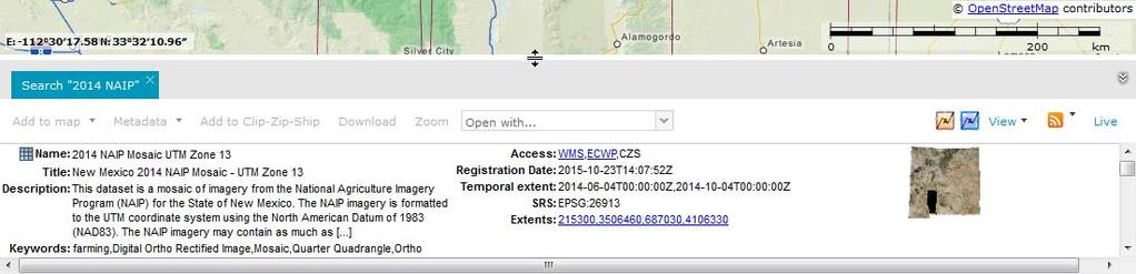
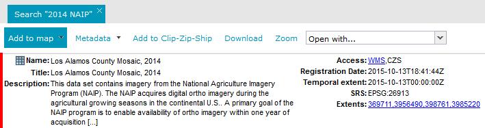
24 Web Services Imagery > Digital Orthophotography > 2014 > NAIP > Mosaic Select Data Set (also in this example, Show Extent and Add to Map)

25 Web Services Right-click on WMS link > select Copy Link Location Add WMS Service to GIS Application
 access Quick Guides at rgis.unm.")
26 NM RGIS Quick Guides and Videos Finding Data Interactive Mapping Downloading Data (includes the new Clip-Zip-Ship function) access Quick Guides at rgis.unm.edu You-Tube Videos
27 QGIS Demo


28 Laura Gleasner, Data Manager ext. 230 Su Zhang, Research Assistant
NM Resource Geographic Information System Program RGIS
 NM Resource Geographic Information System Program RGIS User Guide Access RGIS in any Web browser at http://rgis.unm.edu. Quick Search Bar Main Menu Hyper Links Icon Links Twitter Box Figure 1: RGIS Home
ERDAS APOLLO v2013. What s New. SMARTERDECISIONS
 ERDAS APOLLO v2013 What s New. SMARTERDECISIONS 1 ERDAS APOLLO v2013 ERDAS APOLLO Professional: includes all the functionality of ERDAS APOLLO Advantage. In addition, it provides server side geoprocessing
Addressing Geospatial Big Data Management and Distribution Challenges ERDAS APOLLO & ECW
 Addressing Geospatial Big Data Management and Distribution Challenges ERDAS APOLLO & ECW Nouman Ahmed GeoSystems-Me (Hexagon Geospatial / ERDAS Regional Partner) Enterprise Solutions Architect Hexagon
Presented by Kit Na Goh
 Developing A Geo-Spatial Search Tool Using A Relational Database Implementation of the FGDC CSDGM Model Presented by Kit Na Goh Introduction Executive Order 12906 was issued on April 13, 1994 with the
The What, Why, Who and How of Where: Building a Portal for Geospatial Data. Alan Darnell Director, Scholars Portal
 The What, Why, Who and How of Where: Building a Portal for Geospatial Data Alan Darnell Director, Scholars Portal What? Scholars GeoPortal Beta release Fall 2011 Production release March 2012 OLITA Award
SMARTERDECISIONS. Geospatial Portal 2013 Open Interoperable GIS/Imagery Services with ERDAS Apollo 2013 and ERDAS Imagine 2013
 Geospatial Portal 2013 Open Interoperable GIS/Imagery Services with ERDAS Apollo 2013 and ERDAS Imagine 2013 Carahsoft Intergraph Government Solutions SMARTERDECISIONS Geospatial Portal 2013 Geospatial
Managing Imagery and Raster Data using Mosaic Datasets
 Esri European User Conference October 15-17, 2012 Oslo, Norway Hosted by Esri Official Distributor Managing Imagery and Raster Data using Mosaic Datasets Peter Becker ArcGIS is a Comprehensive Imagery
How to Create Metadata in ArcGIS 10.0
 How to Create Metadata in ArcGIS 10.0 March 2012 Table of Contents Introduction... 1 Getting Started... 2 Software Requirements... 2 Configure ArcGIS Desktop to View FGDC Metadata... 2 Other Thoughts...
Appendix 1: FGDC Press Release
 Appendix 1: FGDC Press Release The United States Geological Survey Federal Geographic Data Committee (FGDC) has awarded $32,150 to the Wyoming State Historic Preservation Office to develop a metadata standard
The Value of Metadata
 The Value of Metadata Why is metadata important to your agency / organization? Metadata has tremendous value to Individuals within your organization, as well as to individuals outside of your organization
Setting Up and Deploying Geospatial Data Shares Using the QGIS Server Application
 Setting Up and Deploying Geospatial Data Shares Using the QGIS Server Application Donald L. Schrupp Wildlife Ecologist Colorado Division of Wildlife (retired) Quantum GIS (QGIS) Applications QGIS is not
THINK RESILIENCY 2.0 WITH VIZONOMY
 VIZONOMY // 01 ABOUT US The greatest advances in climate risk awareness will be those that merge, harness, and properly communicate big data sources to drive meaningful action and response. Vizonomy s
FAQ & Troubleshooting
 FAQ & Troubleshooting What is the most common issue users have when using the site? Pop-Up Blocker!!! Any link external to the viewer requires a new window to be opened in the browser. See My map or report
The Common Framework for Earth Observation Data. US Group on Earth Observations Data Management Working Group
 The Common Framework for Earth Observation Data US Group on Earth Observations Data Management Working Group Agenda USGEO and BEDI background Concise summary of recommended CFEOD standards today Full document
Development of an Interactive Web Interface for Spatial Data Warehousing
 Development of an Interactive Web Interface for Spatial Data Warehousing by Nathan K. Eaton Abstract: Finding a specific file to download is an inherent problem with many online spatial data clearinghouses.
Spatial data and QGIS
 Spatial data and QGIS Xue Jingbo IT Center 2017.08.07 A GIS consists of: Spatial Data. Computer Hardware. Computer Software. Longitude Latitude Disease Date 26.870436-31.909519 Mumps 13/12/2008 26.868682-31.909259
Metadata or "data about data" describe the content, quality, condition, and other characteristics of data. The Federal Geographic Data Committee
 Metadata or "data about data" describe the content, quality, condition, and other characteristics of data. The Federal Geographic Data Committee (http://www.fgdc.gov/) approved the Content Standard for
PRODUCT BROCHURE ERDAS APOLLO MANAGING AND SERVING GEOSPATIAL INFORMATION
 PRODUCT BROCHURE ERDAS APOLLO MANAGING AND SERVING GEOSPATIAL INFORMATION ERDAS APOLLO Do you have large volumes of geospatial information, regularly updated data stores, and a distributed user base? Do
The PICES Metadata Federation: Pacific-wide marine metadata discovery, management and delivery for FUTURE
 PICES 17th Annual Meeting Dalian, People s Republic of China October 30, 2008 The PICES Metadata Federation: Pacific-wide marine metadata discovery, management and delivery for FUTURE S. Allen Macklin
ERDAS APOLLO Managing and Serving Geospatial Information
 ERDAS APOLLO Managing and Serving Geospatial Information ERDAS APOLLO Do you have large volumes of geospatial information, regularly updated data stores, and a distributed user base? Do you need a single,
Metadata for Data Discovery: The NERC Data Catalogue Service. Steve Donegan
 Metadata for Data Discovery: The NERC Data Catalogue Service Steve Donegan Introduction NERC, Science and Data Centres NERC Discovery Metadata The Data Catalogue Service NERC Data Services Case study:
Low-Cost Orthophoto Production Using OrthoMapper Software
 Low-Cost Orthophoto Production Using OrthoMapper Software Rick Day Penn State Cooperative Extension, Geospatial Technology Program, RGIS-Chesapeake Air Photos Historical air photos are available from a
Existing Elevation Data Sets. Quality Level 2 (QL2) Lidar Data Sets. Better Land Characterization More Accurate Results!
 Lidar Data Sets. Better Land Characterization More Accurate Results!") Existing Elevation Data Sets Out of Date: Most > 40 yrs old Data range from 15 yrs old to > 70 yrs old Spatial Resolution: 33 ft (10 m) or coarser Vertical Accuracy: 3.3 ft 6.6 ft (1 2 m) or worse Quality
Existing Elevation Data Sets Out of Date: Most > 40 yrs old Data range from 15 yrs old to > 70 yrs old Spatial Resolution: 33 ft (10 m) or coarser Vertical Accuracy: 3.3 ft 6.6 ft (1 2 m) or worse Quality
IMAGERY FOR ARCGIS. Manage and Understand Your Imagery. Credit: Image courtesy of DigitalGlobe
 IMAGERY FOR ARCGIS Manage and Understand Your Imagery Credit: Image courtesy of DigitalGlobe 2 ARCGIS IS AN IMAGERY PLATFORM Empowering you to make informed decisions from imagery and remotely sensed data
SEXTANT 1. Purpose of the Application
 SEXTANT 1. Purpose of the Application Sextant has been used in the domains of Earth Observation and Environment by presenting its browsing and visualization capabilities using a number of link geospatial
Imagery and Raster Data in ArcGIS. Abhilash and Abhijit
 Imagery and Raster Data in ArcGIS Abhilash and Abhijit Agenda Imagery in ArcGIS Mosaic datasets Raster processing ArcGIS is a Comprehensive Imagery System Integrating All Types, Sources, and Sensor Models
Objectives This tutorial shows how to use the Map Flood tool to quickly generate floodplain data.
 v. 11.0 WMS 11.0 Tutorial Creating a Objectives This tutorial shows how to use the Map Flood tool to quickly generate floodplain data. Prerequisite Tutorials Introduction to WMS Required Components Scatter
Designing and Using Basemaps. Jennifer Hughey
 Designing and Using Basemaps Jennifer Hughey Agenda The ArcGIS System Basemaps are a key component of your system Cartographic design considerations Using basemap layers in ArcMap Best practices for designing
QUESTIONS & ANSWERS FOR. ORTHOPHOTO & LiDAR AOT
 QUESTIONS & ANSWERS FOR ORTHOPHOTO & LiDAR AOT Question# 1. Section 3.2 Will the imagery be clipped to the 1000m boundary? If so, what color will be used for null valued pixels? Yes, the imagery will be
CITY OF SANTA ANA. 20 Civic Center Plaza P.O. Box 1988 Santa Ana, California
 MAYOR MAYOR PRO TEM COUNCILMEMBERS CITY OF SANTA ANA 20 Civic Center Plaza P.O. Box 1988 Santa Ana, California 92702 714-647-6900 www.santa-ana.org CITY MANAGER David Cavazos CITY ATTORNEY Sonia R. Carvalho
QGIS LAB SERIES GST 101: Introduction to Geospatial Technology Lab 7: Basic Geospatial Analysis Techniques
 QGIS LAB SERIES GST 101: Introduction to Geospatial Technology Lab 7: Basic Geospatial Analysis Techniques Objective Use Basic Spatial Analysis Techniques to Solve a Problem Document Version: 2014-06-05
Homeland Security and Geographic Information Systems
 Page 1 of 5 Homeland Security and Geographic Information Systems How GIS and mapping technology can save lives and protect property in post-september 11th America Introduction Timely, accurate information,
From data source to data view: A practical guide to uploading spatial data sets into MapX
 From data source to data view: A practical guide to uploading spatial data sets into MapX Thomas Piller UNEP/GRID Geneva I Table of contents 1. Adding a new data source to MapX... 1 1.1 Method 1: upload
PortalU, a Tool to Support the Implementation of the Shared Environmental Information System (SEIS) in Germany
 in Germany") European conference of the Czech Presidency of the Council of the EU TOWARDS eenvironment Opportunities of SEIS and SISE: Integrating Environmental Knowledge in Europe http:/www.e-envi2009.org/proceedings/
European conference of the Czech Presidency of the Council of the EU TOWARDS eenvironment Opportunities of SEIS and SISE: Integrating Environmental Knowledge in Europe http:/www.e-envi2009.org/proceedings/
ArcGIS for Server Imagery Update. Cody A. Benkelman Technical Product Manager, Imagery
 ArcGIS for Server Imagery Update Cody A. Benkelman Technical Product Manager, Imagery Outline Mosaic dataset Management and dissemination of imagery - Dynamic image services, Tiled Cache Visualization
Fundisa Web Map Applications
 Fundisa Web Map Applications 2013-01-09 Prepared by SANSA Earth Observation 1 Using the SANSA Fundisa Web Map Applications The Fundisa web map applications were created to aid students in their search
Bharath Setturu Research scholar, EWRG, Center for Ecological Sciences, IISc, Bangalore & EWRG-CES IIIT-HYDERABAD
 Bharath Setturu Research scholar, EWRG, Center for Ecological Sciences, IISc, Bangalore settur@ces.iisc.ernet.in & IIIT-HYDERABAD Introduction to QGIS oquantum GIS (QGIS) is a GIS tool for managing geographical
Name * Organization/Agency Name * State * Address * State of State GIS. Jon Gottsegen. ce of Information Technology.
 The primary purpose of the GMA is to provide NSGIC members, its sponsors, and other partners with a detailed summary of geospatial initiatives, capabilities, and issues within and across state governments.
Map Direct Lite. Quick Start Guide: Map Layers 5/14/2018
 Map Direct Lite Quick Start Guide: Map Layers 5/14/2018 Contents Quick Start Guide: Map Layers... 1 Map Layers in Map Direct Lite.... 3 What is a Basemap Layer?... 4 Change the Basemap Using the Basemap
DATA SHARING AND DISCOVERY WITH ARCGIS SERVER GEOPORTAL EXTENSION. Clive Reece, Ph.D. ESRI Geoportal/SDI Solutions Team
 DATA SHARING AND DISCOVERY WITH ARCGIS SERVER GEOPORTAL EXTENSION Clive Reece, Ph.D. ESRI Geoportal/SDI Solutions Team Geoportal Extension for ArcGIS Server Context within an Enterprise Spatial Data Infrastructure
Manitowoc County, WI Advanced Access GIS Viewer User Documentation
 Manitowoc County, WI Advanced Access GIS Viewer User Documentation Introduction Extensive time was put into developing this website both from a display, and from a printing and scaling perspective. This
Overview of SAS/GIS Software
 3 CHAPTER 1 Overview of SAS/GIS Software Introduction to Geographic Information Systems 3 Features of SAS Software 4 Data in SAS/GIS Applications 5 Spatial Data 5 Spatial Data Layers 6 Spatial Data Coverages
CURSO Inspire INSPIRE. Ponente: Pablo Echamendi Lorente. MERCREDI 22/ Wednesday 22 nd W S III : M A K I N G D A T A D I S C O V E R A B L E
 CURSO Inspire MERCREDI 22/ Wednesday 22 nd Ponente: Pablo Echamendi Lorente WS 2 SCHEDULE INTRODUCTION CATALOGUES: OBJECTIVES ORGANISATION DISTRIBUTION ROLES REVISION INTRODUCTION + Information = + difficult
7. METHODOLOGY FGDC metadata
 7. METHODOLOGY To enable an Internet browsing client to search and discover information through a federated metadatabase, four elements must be in place. 1. The client must be able to communicate with
Interactive Maps Purpose: Login to the System: Interactive Maps ONTINUE AGREE
 Interactive Maps Purpose: The purpose of this application is to provide the facility to the citizen to navigate to a Property through an On-line Free Web Application in real time. The application uses
Caching Imagery Using ArcGIS
 2013 Esri International User Conference July 8 12, 2013 San Diego, California Technical Workshop Caching Imagery Using ArcGIS Hong Xu, Hua Wei Esri UC2013. Technical Workshop. Presentation Goals Publish
GeoPortal best practise
 Workshop on Geospatial Data Infrastructure for Economic Development ETT 53097 GeoPortal best practise Tomaž Petek AGENDA Why geoportal Architecture of geoportals Some examples of best practise Example
Server Usage & Third-Party Viewers
 Server Usage & Third-Party Viewers October 2016 HiPER LOOK Version 1.4.16.0 Copyright 2015 PIXIA Corp. All Rights Reserved. Table of Contents HiPER LOOK Server Introduction... 2 Google Earth... 2 Installation...2
Discovery and Access of Geospatial Resources Using GIS Portal Toolkit Marten Hogeweg Product Manager GIS Portal Toolkit
 Discovery and Access of Geospatial Resources Using GIS Portal Toolkit Marten Hogeweg Product Manager GIS Portal Toolkit Outline Elements of Spatial Data Infrastructures Current trends Position of GIS portals
MY DEWETRA IPAFLOODS REPORT
 Grant Contract N. ECHO/SUB/2014/692292 Programme for Prevention, Preparedness and Response to Floods in the Western Balkans and Turkey IPA FLOODS Capacity Building Activities 2016 MY DEWETRA IPAFLOODS
Welcome. to Pre-bid meeting. Karnataka State Spatial Data Infrastructure (KSSDI) Project, KSCST, Bangalore.
 Project, KSCST, Bangalore.") Welcome to Pre-bid meeting Karnataka State Spatial Data Infrastructure (KSSDI) Project, KSCST, Bangalore. DEVELOPMENT OF KARNATAKA STATE SPATIAL DATA INFRASTRUCTURE (KSSDI) PROJECT Objective: To develop
Welcome to Pre-bid meeting Karnataka State Spatial Data Infrastructure (KSSDI) Project, KSCST, Bangalore. DEVELOPMENT OF KARNATAKA STATE SPATIAL DATA INFRASTRUCTURE (KSSDI) PROJECT Objective: To develop
9. GIS Data Collection
 9. GIS Data Collection Geographic Information Systems and Science SECOND EDITION Paul A. Longley, Michael F. Goodchild, David J. Maguire, David W. Rhind 2005 John Wiley and Sons, Ltd Overview Introduction
NMCRIS Map Service Application Prefield Query
 NMCRIS Map Service Application Prefield Query Exercise goal: As part of prefield activities conducted in advance of field investigations, this exercise instructs users to perform spatial queries of activities
Egyptian Survey Authority Geographic Information Management System (ESA GIM)
") Egyptian Survey Authority Geographic Information Management System (ESA GIM) Sohail El ABD and Kholoud SAAD, Egypt Key words: GIS, theme, etc. SUMMARY ESA can be regarded as the backbone for supplying
Egyptian Survey Authority Geographic Information Management System (ESA GIM) Sohail El ABD and Kholoud SAAD, Egypt Key words: GIS, theme, etc. SUMMARY ESA can be regarded as the backbone for supplying
EEOS 381 -Spatial Databases and GIS Applications
 EEOS 381 -Spatial Databases and GIS Applications Lecture 2 Data Sources Data Development and Data QA/QC Guiding Principle Good quality GIS data make up the foundation of all maps and spatial analyses and
National Geospatial Data Repository Centralised or Distributed?
 National Geospatial Data Repository Centralised or Distributed? Dr. Aniruddha Roy Vice President Navayuga New Delhi, INDIA Presentation Overview NGDR - Prespective NGDR - Stakeholders Boundary Consistency
Singapore. Mr Soh Kheng Peng. Singapore Land Authority
 Country Report 2006 (Based on the PCGIAP-Data Integration Template 2006) Singapore Country/state: Name of contact person: Affiliation, Organization: Function, Position: Address: Email address: Tel, Fax
Managing Imagery And Raster Data Using Mosaic Dataset. Peter Becker & Cody Benkelman
 Managing Imagery And Raster Data Using Mosaic Dataset Peter Becker & Cody Benkelman ArcGIS is a Comprehensive Imagery Platform Imagery is integral to the ArcGIS Platform System of Engagement System of
Bharath Setturu Research scholar, EWRG, Center for Ecological Sciences, IISc, Bangalore & IIIT-HYDERABAD
 Bharath Setturu Research scholar, EWRG, Center for Ecological Sciences, IISc, Bangalore settur@ces.iisc.ernet.in & IIIT-HYDERABAD Introduction to QGIS oquantum GIS (QGIS) is a GIS tool for managing geographical
Comparison of Metadata Standards A Proposal for Hungarian Core Metadata Standard
 Comparison of Metadata Standards A Proposal for Hungarian Core Metadata Standard Enikõ Kovács Institute of Geodesy, Cartography and Remote Sensing H-1149 Budapest, Bosnyák tér 5. Eniko.kovacs@fomigate.fomi.hu
How to Create a Tile Package
 United States Department of Agriculture Digital Mobile Sketch Mapping (DMSM) How to Create a Tile Package (TPK) Forest Service Introduction A tile package (.tpk) allows you to use a set of packaged tiles
MODULE 1 BASIC LIDAR TECHNIQUES
 MODULE SCENARIO One of the first tasks a geographic information systems (GIS) department using lidar data should perform is to check the quality of the data delivered by the data provider. The department
IGIC Helping Coordinate GIS Initiatives for Indiana
 IGIC Helping Coordinate GIS Initiatives for Indiana GIS Day at Purdue University 2014 Phil Worrall, Executive Director Indiana Geographic Information Council, Inc. (IGIC) IGIC Helping Coordinate GIS Initiatives
State Research Needs in GIS
 State Research Needs in GIS Robert Fuhler GIS Section Environmental Division Arkansas State Highway and Transportation Department GIS T, Nashville Tennessee March 27, 2007 Research Needs Most Common Research
IMAGINE Objective. The Future of Feature Extraction, Update & Change Mapping
 IMAGINE ive The Future of Feature Extraction, Update & Change Mapping IMAGINE ive provides object based multi-scale image classification and feature extraction capabilities to reliably build and maintain
Multi-LCC Mississippi River Basin Gulf Hypoxia Initiative. ScienceBase and Data Basin User Guide
 Multi-LCC Mississippi River Basin Gulf Hypoxia Initiative ScienceBase and Data Basin User Guide Data delivery for the Gulf Hypoxia Initiative is carried out through the use of two websites: ScienceBase
Esri Geoportal Server
 Esri Geoportal Server Implementing a Spatial Data Infrastructure @martenhogeweg Esri Geoportal Server Extending ArcGIS to enable discovery and use of geospatial resources in heterogeneous environments
A ONE-STOP SERVICE HUB INTEGRATING ESSENTIAL WEATHER AND GEOPHYSICAL INFORMATION ON A GIS PLATFORM. Hong Kong Observatory
 A ONE-STOP SERVICE HUB INTEGRATING ESSENTIAL WEATHER AND GEOPHYSICAL INFORMATION ON A GIS PLATFORM Hong Kong Observatory Mission HONG KONG OBSERVATORY To provide people-oriented quality services in meteorology
Enterprise Geospatial Activities in the Bureau of Reclamation Mid-Pacific Region
 in the Bureau of Reclamation Mid-Pacific Region Toward an Organizational Nervous System?? Lorri Peltz-Lewis, Regional Geospatial Database Administrator and Dave Hansen, GIS Specialist What is Enterprise?
Quality Control Concepts for LiDAR
 Quality Control Concepts for LiDAR January 24, 2012 Engineering Architecture Design-Build Surveying GeoSpatial Solutions Presentation Objectives Offer realistic and constructive advice for LiDAR project
IndianaMap Release 3. Rick Hill, Paul Rohwer,, Chris Dintaman, Becky Meyer, and Denver Harper
 IndianaMap Release 3 Rick Hill, Paul Rohwer,, Chris Dintaman, Becky Meyer, and Denver Harper IndianaMap Agenda Session 1 & 2 Overview Tentative rollout schedule Old versus New Design and construction of
Mississippi Public Schools 2015
 Mississippi Public Schools 2015 Shapefile and geodatabase Tags education, administrative, schools, public, K-12 Summary To add to the state data clearinghouse the Mississippi public schools point feature.
GIS Basics for Urban Studies
 GIS Basics for Urban Studies Date: March 21, 2018 Contacts: Mehdi Aminipouri, Graduate Peer GIS Faciliator, SFU Library (maminipo@sfu.ca) Keshav Mukunda, GIS & Map Librarian Librarian for Geography (kmukunda@sfu.ca)
GeoDCAT-AP Representing geographic metadata by using the "DCAT application profile for data portals in Europe"
 GeoDCAT-AP Representing geographic metadata by using the "DCAT application profile for data portals in Europe" Andrea Perego, Vlado Cetl, Anders Friis-Christensen, Michael Lutz, Lorena Hernandez Joint
UTILIZACIÓN DE DATOS LIDAR Y SU INTEGRACIÓN CON SISTEMAS DE INFORMACIÓN GEOGRÁFICA
 UTILIZACIÓN DE DATOS LIDAR Y SU INTEGRACIÓN CON SISTEMAS DE INFORMACIÓN GEOGRÁFICA Aurelio Castro Cesar Piovanetti Geographic Mapping Technologies Corp. (GMT) Consultores en GIS info@gmtgis.com Geographic
Iowa s Statewide Road Centerline Cooperative Program. Bill Schuman, GIS Coordinator Iowa Department of Transportation
 Iowa s Statewide Road Centerline Cooperative Program Bill Schuman, GIS Coordinator Iowa Department of Transportation Session Outline Current goals of Statewide Road Centerline Project Project challenges
ArcGIS Online: Managing Data. Jeremy Bartley Sentha Sivabalan
 ArcGIS Online: Managing Data Jeremy Bartley (jbartley@esri.com) Sentha Sivabalan (ssivabalan@esri.com) Agenda Creating and managing content like Apps, Maps, Scenes and Layers in ArcGIS Today s Topics:
ERDAS Image Web Server Datasheet
 ERDAS Image Web Server Datasheet age 1 of 10 ERDAS Image Web Server Image serving protocols Multi-protocol support Expose images with different protocols. ERDAS Compressed Wavelet Protocol (ECWP) image
Name * Organization/Agency Name * State * Address * State of State GIS. Julia Fischer. Department of Information Technology.
 The primary purpose of the GMA is to provide NSGIC members, its sponsors, and other partners with a detailed summary of geospatial initiatives, capabilities, and issues within and across state governments.
Lidar Talking Points Status of lidar collection in Pennsylvania Estimated cost and timeline
 Lidar Talking Points Pennsylvania has an immediate need for new lidar (topographic) data coverage. Some uses of the data are enumerated later in this document. USGS has calculated an average return on
Advanced Map Caching. Tom Brenneman
 Advanced Map Caching g Topics Sterling Quinn Tom Brenneman Schedule Advanced topics Key caching properties C Caching g strategies g Test caches Strategic cache creation On--demand caching On Creating a
PUBLIC WORKS. 1oo. DiEital Fee Schedules. Effective January 1, 2008
 PUBLIC WORKS Geographic Information Systems DiEital Fee Schedules Effective January 1, 2008 Date Advertised 12103/07 In (Publication) Daily Business Journal Public Hearing Date Approved as to form: David
GEOMEDIA MOTION VIDEO ANALYSIS PROFESSIONAL
 GEOMEDIA MOTION VIDEO ANALYSIS PROFESSIONAL GEOMEDIA MOTION VIDEO ANALYSIS PROFESSIONAL Hexagon Geospatial s GeoMedia Motion Video Analysis Professional provides a high-productivity environment for analysis
GEOSPATIAL ERDAS APOLLO. Your Geospatial Business System for Managing and Serving Information
 GEOSPATIAL ERDAS APOLLO Your Geospatial Business System for Managing and Serving Information ERDAS APOLLO Do you have large volumes of data, a geographicallydistributed user base and rapidly changing
EarthCube and Cyberinfrastructure for the Earth Sciences: Lessons and Perspective from OpenTopography
 EarthCube and Cyberinfrastructure for the Earth Sciences: Lessons and Perspective from OpenTopography Christopher Crosby, San Diego Supercomputer Center J Ramon Arrowsmith, Arizona State University Chaitan
Leveraging metadata standards in ArcGIS to support Interoperability. David Danko and Aleta Vienneau
 Leveraging metadata standards in ArcGIS to support Interoperability David Danko and Aleta Vienneau Leveraging Metadata Standards in ArcGIS for Interoperability Why metadata and metadata standards? Overview
NEXT GENERATION WHITE PAPER GEOSPATIAL CONTENT MANAGEMENT
 NEXT GENERATION GEOSPATIAL CONTENT MANAGEMENT WHITE PAPER Progressive Technology Federal Systems 11501 Huff Court, North Bethesda, MD 20895 www.ptfs.com 1. OVERVIEW Knowvation GS TM is an enterprise geospatial
Building a National Address Database. Presented by Steve Lewis, Department of Transportation Mark Lange, Census Bureau July 13, 2017
 Building a National Address Database Presented by Steve Lewis, Department of Transportation Mark Lange, Census Bureau July 13, 2017 Topics Building the NAD FGDC Address Theme 2 Building the NAD 3 First
New Features in TNTmips 2010
 61st Release February 2010 New Features in TNTmips 2010 A tileset is a collection of small image files called tiles in a predefined file size, format, and directory structure. It is designed for efficient
Ag-Analytics Data Platform
 Ag-Analytics Data Platform Joshua D. Woodard Assistant Professor and Zaitz Faculty Fellow in Agribusiness and Finance Dyson School of Applied Economics and Management Cornell University NY State Precision
GEO-SPATIAL METADATA SERVICES ISRO S INITIATIVE
 GEO-SPATIAL METADATA SERVICES ISRO S INITIATIVE Pushpalata B Shah, Navita J Thakkar Space Applications Centre (ISRO) Ahmedabad 380 015 - pushpa@sac.isro.gov.in Commission IV, Working Group IV/5 KEYWORDS:
The US Census Geographic Support System Initiative (GSS-I): Working with Partners for Enhanced Data Management KY GIS Conference, 10/01/13
: Working with Partners for Enhanced Data Management KY GIS Conference, 10/01/13") The US Census Geographic Support System Initiative (GSS-I): Working with Partners for Enhanced Data Management KY GIS Conference, 10/01/13 Kevin Holmes, Geographer US Census Bureau: Philadelphia Regional
The US Census Geographic Support System Initiative (GSS-I): Working with Partners for Enhanced Data Management KY GIS Conference, 10/01/13 Kevin Holmes, Geographer US Census Bureau: Philadelphia Regional
Outline. The Collaborative Research Platform for Data Curation and Repositories: CKAN For ANGIS Data Portal. Open Access & Open Data.
 Outline The Collaborative Research Platform for Data Curation and Repositories: CKAN For ANGIS Data Portal Open Access & Open Data ANGIS data portal New developed features Future works Hsiung-Ming Liao,
PROJECT BRIEFINGS: Statewide 2008 Orthoimagery LiDAR Elevation Data Program MN Geospatial Information Office. Chris Cialek
 PROJECT BRIEFINGS: Statewide 2008 Orthoimagery LiDAR Elevation Data Program MN Geospatial Information Office Chris Cialek MN Land Management Information Center (LMIC) chris.cialek@state.mn.us Mid-West
Peoria County Front Desk Map Application
 Peoria County Front Desk Map Application Quick Guide, 2017 At a First Glance This guide will tell users all they need to know about the Peoria County Front Desk application which can be found on the Peoria
Introduction to SDIs (Spatial Data Infrastructure)
") www.grid.unep.ch Regional training workshop on geographical information system for energy planning Introduction to SDIs (Spatial Data Infrastructure) Dakar, 12 August 2014 Gregory Giuliani Andrea de Bono,
www.grid.unep.ch Regional training workshop on geographical information system for energy planning Introduction to SDIs (Spatial Data Infrastructure) Dakar, 12 August 2014 Gregory Giuliani Andrea de Bono,
Tutorial International Standards. Web Map Server (WMS) & Web Feature Server (WFS) Overview
 & Web Feature Server (WFS) Overview") ISO/TC 211 17 th Plenary & Associated Meetings Berlin, Germany, DIN Institute / 2003-10-31 Advisory Group on Outreach Tutorial International Standards Web Map Server (WMS) & Web Feature Server (WFS) Overview
ISO/TC 211 17 th Plenary & Associated Meetings Berlin, Germany, DIN Institute / 2003-10-31 Advisory Group on Outreach Tutorial International Standards Web Map Server (WMS) & Web Feature Server (WFS) Overview
Introduction to Geospatial Technology Lab Series. Lab: Basic Geospatial Analysis Techniques
 Introduction to Geospatial Technology Lab Series Lab: Basic Geospatial Analysis Techniques Document Version: 2012-08-24 Lab Author: Richard Smith Organization: Copyright 2003-2012 Center for Systems Security
P&D GIS Map How-To-Guide Thomas Fire / January 9, 2018 Debris Flow
 P&D GIS Map How-To-Guide The interactive GIS web-based map is available here. Once you have accessed the map, type in your address in the field on the top right corner and click on the magnifying glass