Po P ls l A S Rpro v5.0. Pr P actic i al E. E. Po P ttie i r E.Pottier (2013)
|
|
|
- Terence Miller
- 6 years ago
- Views:
Transcription

1 PolSARprov5.0 Practical E. Pottier
2 General Presentation of PolSARpro v5.0 Software


3 SOFTWARE DIRECTORY STRUCTURE PolSARpro_v5.0.tcl is the executable file that launches the POLSARPRO user interface
![DATA DIRECTORY STRUCTURE Compatible Raw Binary Data 2x2 Complex Sinclair Matrix [S2] DATADIR config.txt s11.bin, s12.bin s21.bin, s22.bin PolarCase Monostatic s12.bin == s21.bin Bistatic s12.](/docs-images/76/74249340/images/4-4.jpg "bin <> s21.bin Intensities Ixy.bin PolarType Full s11.bin, s12.bin, s21.bin, s22.bin pp1 s11.bin, s21.bin pp2 s12.bin, s22.bin pp3 s11.bin, s22.bin pp4 I11.bin, I12.bin, I22.bin pp5 I11.bin, I21.")
4 DATA DIRECTORY STRUCTURE Compatible Raw Binary Data 2x2 Complex Sinclair Matrix [S2] DATADIR config.txt s11.bin, s12.bin s21.bin, s22.bin PolarCase Monostatic s12.bin == s21.bin Bistatic s12.bin <> s21.bin Intensities Ixy.bin PolarType Full s11.bin, s12.bin, s21.bin, s22.bin pp1 s11.bin, s21.bin pp2 s12.bin, s22.bin pp3 s11.bin, s22.bin pp4 I11.bin, I12.bin, I22.bin pp5 I11.bin, I21.bin pp6 I12.bin, I22.bin pp7 I11.bin, I22.bin Nrow Ncol PolarCase Monostatic/Bistatic/Intensities PolarType Full/pp1/pp2/pp3/pp4/pp5/pp6/pp7
5 DATA DIRECTORY STRUCTURE Compatible Raw Binary Data 3x3 Complex Coherency Matrix [T3] DATADIR T3 config.txt T11.bin, T12_real.bin, T12_imag.bin, T13_real.bin, T13_imag.bin, T22.bin, T23_real.bin, T23_imag.bin, T33.bin Nrow Ncol PolarCase Monostatic/Bistatic PolarType Full


6 DATA DIRECTORY STRUCTURE Compatible Raw Binary Data 3x3 Complex Covariance Matrix [C3] DATADIR C3 config.txt C11.bin, C12_real.bin, C12_imag.bin, C13_real.bin, C13_imag.bin, C22.bin, C23_real.bin, C23_imag.bin, C33.bin Nrow Ncol PolarCase Monostatic/Bistatic PolarType Full
![DATA DIRECTORY STRUCTURE Compatible Raw Binary Data 4x4 Complex Coherency Matrix [T4] DATADIR T4 config.txt T11.bin, T12_real.bin, T12_imag.bin, T13_real.bin, T13_imag.bin, T14_real.bin, T14_imag.](/docs-images/76/74249340/images/7-4.jpg "bin, T22.bin, T23_real.bin, T23_imag.bin, T24_real.bin, T24_imag.bin, T33.bin, T34_real.bin, T34_imag.bin, T44.")
7 DATA DIRECTORY STRUCTURE Compatible Raw Binary Data 4x4 Complex Coherency Matrix [T4] DATADIR T4 config.txt T11.bin, T12_real.bin, T12_imag.bin, T13_real.bin, T13_imag.bin, T14_real.bin, T14_imag.bin, T22.bin, T23_real.bin, T23_imag.bin, T24_real.bin, T24_imag.bin, T33.bin, T34_real.bin, T34_imag.bin, T44.bin Nrow Ncol PolarCase Bistatic PolarType Full
8 DATA DIRECTORY STRUCTURE Compatible Raw Binary Data 4x4 Complex Covariance Matrix [C4] DATADIR C4 config.txt C11.bin, C12_real.bin, C12_imag.bin, C13_real.bin, C13_imag.bin, C14_real.bin, C14_imag.bin, C22.bin, C23_real.bin, C23_imag.bin, C24_real.bin, C24_imag.bin, C33.bin, C34_real.bin, C34_imag.bin, C44.bin Nrow Ncol PolarCase Bistatic PolarType Full


9 CONFIGURATION
10 PolSARpro v5.0 SOFTWARE MAIN WINDOW ENTRY SCREEN
11 PolSARpro v5.0 SOFTWARE PolSARpro v5.0 MAIN WINDOW Full Screen
12 PolSARpro v5.0 SOFTWARE

13 PolSARpro v5.0 SOFTWARE
14 PolSARpro v5.0 SOFTWARE
15 PolSARpro v5.0 SOFTWARE
16 PolSARpro v5.0 SOFTWARE
17 PolSARpro v5.0 SOFTWARE
18 PolSARpro v5.0 SOFTWARE

19 PolSARpro v5.0 SOFTWARE
20 PolSARpro v5.0 SOFTWARE

21 PolSARpro v5.0 SOFTWARE
22 PolSARpro v5.0 SOFTWARE
23 PolSARpro v5.0 SOFTWARE
24 TEST THE CONFIGURATION


25 PolSARpro v5.0 SOFTWARE Test

26 PolSARpro v5.0 SOFTWARE Config


27 PolSARpro v5.0 SOFTWARE Test
28 PolSARpro v5.0 SOFTWARE Config


29 PolSARpro v5.0 SOFTWARE Test
30 PolSARpro v5.0 SOFTWARE Config
31 PolSARpro v5.0 SOFTWARE Test
32 PolSARpro v5.0 SOFTWARE Config
33 PolSARpro v5.0 SOFTWARE Config
34 Questions?

35 ALOS : Advanced Land Observing Satellite PALSAR : Phase Array L-Band SAR
36 PolSARpro v5.0 SOFTWARE
37 PolSARpro v5.0 SOFTWARE PolSARpro Full Software Single Data Set Multi Data Sets Spaceborne Sensors: ALOS, ENVISAT RADARSAT2, TerraSar, SIR-C Airborne Sensors: AIRSAR, Convair, EMISAR ESAR, PISAR, RAMSES Version for the EO Scientific Investigator
38 PROCESSING CHAIN PolSARpro v5.0 Software performs complete end-to-end processing without the need for any other software. Data Processing Approach along a recommended and easy processing chain Provide a First Qualitative Analysis of the fully polarimetric data set processed Configuration Data Import Data Process Data Display Input Data File QuickLook Extract Raw Data [T3] Elements Speckle Filtering Box Car Gaussian Lee Refined H / A / Alpha Decomposition Parameters Eigenvectors Parameters Eigenvalues Parameters Polarimetric Segmentation H / A / alpha Segmentation Unsupervised Wishart H / A / alpha Segmentation Supervised Wishart H / A / alpha Segmentation Batch Process Speckle Filtering H / A / alpha Decomposition Unsupervised Wishart H / A / alpha Segmentation BMP 8 / 24 bits RGB


39 MAIN MENU
40 MAIN MENU Environment Import Data Display Process Data
41 PROCESSING CHAIN Configuration Data Import Data Process Data Display Input Data File QuickLook Extract Raw Data [T3] Elements Speckle Filtering Box Car Gaussian Lee Refined H / A / Alpha Decomposition Parameters Eigenvectors Parameters Eigenvalues Parameters Polarimetric Segmentation H / A / alpha Segmentation Unsupervised Wishart H / A / alpha Segmentation Supervised Wishart H / A / alpha Segmentation Batch Process Speckle Filtering H / A / alpha Decomposition Unsupervised Wishart H / A / alpha Segmentation BMP 8 / 24 bits RGB
42 PROCESSING CHAIN Configuration Data Import Data Process Data Display Input Data File QuickLook Extract Raw Data [T3] Elements Speckle Filtering Box Car Gaussian Lee Refined H / A / Alpha Decomposition Parameters Eigenvectors Parameters Eigenvalues Parameters Polarimetric Segmentation H / A / alpha Segmentation Unsupervised Wishart H / A / alpha Segmentation Supervised Wishart H / A / alpha Segmentation Batch Process Speckle Filtering H / A / alpha Decomposition Unsupervised Wishart H / A / alpha Segmentation BMP 8 / 24 bits RGB
43 ENVIRONNEMENT Environment Import Data Display Process Data
44 ENVIRONMENT Configure Data Main Directory location Input Directory: C:/ DataDirectory SAN_FRANCISCO_ALOS
45 ENVIRONMENT Configure Data Main Directory location Automatic Data Check (Null or NaN) Configuration File (ENVI) Image Display Size setting


46 ENVIRONMENT Configure Data Main Directory location Color Palette Edition & Modification
47 PROCESSING CHAIN Configuration Data Import Data Process Data Display Input Data File QuickLook Extract Raw Data [T3] Elements Speckle Filtering Box Car Gaussian Lee Refined H / A / Alpha Decomposition Parameters Eigenvectors Parameters Eigenvalues Parameters Polarimetric Segmentation H / A / alpha Segmentation Unsupervised Wishart H / A / alpha Segmentation Supervised Wishart H / A / alpha Segmentation Batch Process Speckle Filtering H / A / alpha Decomposition Unsupervised Wishart H / A / alpha Segmentation BMP 8 / 24 bits RGB
48 ENVIRONNEMENT Environment Import Data Display Process Data

49 Data IMPORT Input Data File


50 Data IMPORT Input Data File Do it Yourself: Enter SAR Leader File Check File
51 Data IMPORT Input Data File Do it Yourself: Enter SAR Leader File Read Header OK


52 Data IMPORT Input Data File


53 Data IMPORT Input Data File

54 Data IMPORT Extract Binary Data

55 Data IMPORT Extract Binary Data Do it Yourself: Multi Look : Row = 8 Col = 1 Run
56 Data IMPORT Extract Binary Data Convert ALOS Fully Polarimetric Data Files to Complex (3x3) Coherency Matrix [T3] INPUT DIR OUTPUT DIR Fully Polarimetric Data Files T3 config.txt Do it Yourself: T11.bin, T12_real.bin, T12_imag.bin, T13_real.bin, T13_imag.bin, T22.bin T23_real.bin, T23_imag.bin, T33.bin Multi Look : Row = 8 Col = 1 Run
57 Display Pauli-RGB Image Open BMP File
58 PolSARpro v5.0 SOFTWARE SRTM ASTER
59 Overlay SRTM Image - Google Download


60 Overlay SRTM Image - Google
61 Overlay SRTM Image - Google Extract


62 Overlay SRTM Image - Google Display


63 Overlay SRTM Image - Google
64 Overlay ASTER Image - Google Download
65 Overlay ASTER Image - Google


66 Overlay ASTER Image - Google Extract

67 Overlay ASTER Image - Google Display
68 Overlay ASTER Image - Google
69 PolSARpro v5.0 MAP READY SOFTWARES


![PALSAR Only valid for: [C2]](/docs-images/76/74249340/images/70-5.jpg "matrix: Dual-Pol [T3]")
70 PolSARpro v5.0 SOFTWARE MAP READY Pre-Processing Data Extract [T3] Geo-Coding Terrain Correct - UTM Proj. Post - Processing ALOS - PALSAR Only valid for: [C2] matrix: Dual-Pol [T3] matrix: Quad-Pol KML File generation


71 PolSARpro v5.0 SOFTWARE
72 PolSARpro v5.0 SOFTWARE
73 PolSARpro v5.0 SOFTWARE


74 PolSARpro v5.0 SOFTWARE


75 Display Pauli-RGB Image Open BMP File


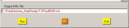
76 Create Pauli-RGB to KML Image
77 GOOGLE EARTH
78 PROCESSING CHAIN Configuration Data Import Data Process Data Display Input Data File QuickLook Extract Raw Data [T3] Elements Speckle Filtering Box Car Gaussian Lee Refined H / A / Alpha Decomposition Parameters Eigenvectors Parameters Eigenvalues Parameters Polarimetric Segmentation H / A / alpha Segmentation Unsupervised Wishart H / A / alpha Segmentation Supervised Wishart H / A / alpha Segmentation Batch Process Speckle Filtering H / A / alpha Decomposition Unsupervised Wishart H / A / alpha Segmentation BMP 8 / 24 bits RGB
79 PROCESS DATA Environment Import Data Display Process Data
80 PROCESS DATA
81 PROCESS DATA
![[T3] ELEMENTS DATADIR T3 config.](/docs-images/76/74249340/images/82-2.jpg "txt [T3x3] Elements Txy_mod.bin Txy_db.")


82 [T3] ELEMENTS DATADIR T3 config.txt [T3x3] Elements Txy_mod.bin Txy_db.bin Txy_pha.bin Txy_mod.bmp Txy_db.bmp Txy_pha.bmp Do it Yourself: Select some elements, set the parameters and view the corresponding BMP files (select BMP).
![[T3]](/docs-images/76/74249340/images/83-5.jpg "ELEMENTS")


83 [T3] ELEMENTS T11_dB T22_dB T33_dB
![[T3]](/docs-images/76/74249340/images/84-2.jpg "ELEMENTS")

84 [T3] ELEMENTS span_db T12_pha
85 PROCESSING CHAIN Configuration Data Import Data Process Data Display Input Data File QuickLook Extract Raw Data [T3] Elements Speckle Filtering Box Car Gaussian Lee Refined H / A / Alpha Decomposition Parameters Eigenvectors Parameters Eigenvalues Parameters Polarimetric Segmentation H / A / alpha Segmentation Unsupervised Wishart H / A / alpha Segmentation Supervised Wishart H / A / alpha Segmentation Batch Process Speckle Filtering H / A / alpha Decomposition Unsupervised Wishart H / A / alpha Segmentation BMP 8 / 24 bits RGB
86 PROCESS DATA


87 DECOMPOSITION PARAMETERS Do it Yourself: Select some elements, set the parameters and view the corresponding BMP files (select BMP).
88 DECOMPOSITION PARAMETERS Entropy Anisotropy Alpha
89 DECOMPOSITION PARAMETERS H (1-A) HA
90 DECOMPOSITION PARAMETERS (1 H) A (1-H) (1-A)
91 PROCESSING CHAIN Configuration Data Import Data Process Data Display Input Data File QuickLook Extract Raw Data [T3] Elements Speckle Filtering Box Car Gaussian Lee Refined H / A / Alpha Decomposition Parameters Eigenvectors Parameters Eigenvalues Parameters Polarimetric Segmentation H / A / alpha Segmentation Unsupervised Wishart H / A / alpha Segmentation Supervised Wishart H / A / alpha Segmentation Batch Process Speckle Filtering H / A / alpha Decomposition Unsupervised Wishart H / A / alpha Segmentation BMP 8 / 24 bits RGB


92 PROCESS DATA

 and view the")
93 H / A / alpha CLASSIFICATION Do it Yourself: Select some elements, set the parameters (Nwin = 1) and view the corresponding BMP files.
94 H / A / alpha CLASSIFICATION DATADIR config.txt [T3x3] Elements entropy.bin, anisotropy.bin, alpha.bin combination_ha.bin, combination_1mha.bin, combination_h1ma.bin, combination_1mh1ma.bin H_A_class.bin, H_Alpha_class.bin, A_Alpha_class.bin Do it Yourself: Select some elements, set the parameters (Nwin = 1) and view the corresponding BMP files. entropy.bmp, anisotropy.bmp, alpha.bmp combination_ha.bmp, combination_1mha.bmp, combination_h1ma.bmp, combination_1mh1ma.bmp H_A_class.bmp, H_Alpha_class.bmp, A_Alpha_class.bmp H_A_occurence.bmp, H_Alpha_ occurence.bmp, A_Alpha_ occurence.bmp, H_A_segmented.bmp, H_Alpha_ segmented.bmp, A_Alpha_ segmented.bmp HAlphaLambda_RGB.bmp, HAAlpha_RGB.bmp HACombinations_RGB.bmp


95 H / A / alpha CLASSIFICATION

 and view the")
96 H / A / alpha CLASSIFICATION Do it Yourself: Select some elements, set the parameters (Nwin = 1) and view the corresponding BMP files.
97 H / A / alpha CLASSIFICATION DATADIR config.txt [T3x3] Elements H_alpha_lambda_class1(2,3).bin, H_alpha_lambda_occurence_class1(2,3).bin, H_alpha_lambda_segmented_class1(2,3).bin, H_alpha_lambda_class.bin, Do it Yourself: Select some elements, set the parameters (Nwin = 1) and view the corresponding BMP files. H_alpha_lambda_class1(2,3).bmp, H_alpha_lambda_occurence_class1(2,3).bmp, H_alpha_lambda_segmented_class1(2,3).bmp, H_alpha_lambda_class.bmp,


98 H / A / alpha CLASSIFICATION Low λ Medium λ High λ


99 H / A / alpha CLASSIFICATION Low λ Medium λ High λ


100 H / A / alpha CLASSIFICATION

101 ENVIRONNEMENT Processing Configuration


102 Questions?
Software Tool PolSARpro v3.0
 Software Tool PolSARpro v3.0 Eric POTTIER Tuesday 4 September, Lecture D2L5-2 04/09/07 Lecture D2L5 part 2 Software Tool : PolSARpro v3.0 Eric POTTIER 1 CONTEXT The initiative development of PolSARpro
Eric Pottier, Laurent Ferro-Famil, Sophie Allain, Stéphane Méric. Irena Hajnsek, Kostas Papathanassiou, Alberto Moreira,
 PolSARpro v4.0 Software and ALOS-PALSAR Pol-SAR Data Processing Eric Pottier, Laurent Ferro-Famil, Sophie Allain, Stéphane Méric Shane Cloude, Irena Hajnsek, Kostas Papathanassiou, Alberto Moreira, Mark
TECHNICAL SPECIFICATIONS AND ARCHITECTURE DESIGN
 POLSARPRO V4.0 TECHNICAL SPECIFICATIONS AND ARCHITECTURE DESIGN 1 INTRODUCTION This document is dedicated to a basic presentation of the PolSARpro v4.0 Software technical specifications, architecture design
PolSARpro v4.03 Forest Applications
 PolSARpro v4.03 Forest Applications Laurent Ferro-Famil Lecture on polarimetric SAR Theory and applications to agriculture & vegetation Thursday 19 April, morning Pol-InSAR Tutorial Forest Application
PolSARpro v4.0 Main Window
 PolSARpro v4.0 Main Window Figure n 1 : PolSARpro v4.0 Main Window Description: The PolSARpro v4.0 Software proposes a new interface based on a full-screen main window as shown in Figure n 1. Minimizing
An Overview of the PolSARpro v3.0 Software The Educational Toolbox for Polarimetric and Interferometric Polarimetric SAR Data Processing
 An Overview of the PolSARpro v3.0 Software The Educational Toolbox for Polarimetric and Interferometric Polarimetric SAR Data Processing Eric Pottier, Laurent Ferro-Famil, Sophie Allain Shane Cloude, Irena
Do It Yourself 8. Polarization Coherence Tomography (P.C.T) Training Course
 Training Course") Do It Yourself 8 Polarization Coherence Tomography (P.C.T) Training Course 1 Objectives To provide a self taught introduction to Polarization Coherence Tomography (PCT) processing techniques to enable
Do It Yourself 8 Polarization Coherence Tomography (P.C.T) Training Course 1 Objectives To provide a self taught introduction to Polarization Coherence Tomography (PCT) processing techniques to enable
SNAP-Sentinel-1 in a Nutshell
 SNAP-Sentinel-1 in a Nutshell Dr. Andrea Minchella 1 st ESA Advanced Training Course on Remote Sensing of the Cryosphere 13 September 2016, University of Leeds, Leeds, UK What is SNAP? Credit: SNAP The
Automated feature extraction by combining polarimetric SAR and object-based image analysis for monitoring of natural resource exploitation
 DLR.de Chart 1 Automated feature extraction by combining polarimetric SAR and object-based image analysis for monitoring of natural resource exploitation Simon Plank, Alexander Mager, Elisabeth Schoepfer
SNAP-Sentinel-1 in a Nutshell
 SNAP-Sentinel-1 in a Nutshell Dr. Andrea Minchella 21-22/01/2016 ESA SNAP-Sentinel-1 Training Course Satellite Applications Catapult - Electron Building, Harwell, Oxfordshire What is SNAP? Credit: SNAP
POLSARpro v3.0: THE VERSATILE EDUCATIONAL TOOLBOX FOR POLARIMETRIC AND INTERFEROMETRIC SAR DATA PROCESSING
 POLSARpro v3.0: THE VERSATILE EDUCATIONAL TOOLBOX FOR POLARIMETRIC AND INTERFEROMETRIC SAR DATA PROCESSING Eric Pottier (1), Laurent Ferro-Famil (1), Sophie Allain (1), Shane Cloude (2), Irena Hajnsek
NEST 4C-1.1: an ESA toolbox for scientific exploitation of SAR data
 NEST 4C-1.1: an ESA toolbox for scientific exploitation of SAR data Andrea Minchella RSAC c/o European Space Agency ESRIN EO Science, Applications and New Technologies Department Exploitation & Services
Forest Retrievals. using SAR Polarimetry. (Practical Session D3P2a)
") Forest Retrievals using SAR Polarimetry (Practical Session D3P2a) Laurent FERRO-FAMIL - Eric POTTIER University of Rennes 1 Pol-InSAR Practical Forest Application PolSARpro SIM PolSARproSim is a rapid,
Forest Retrievals using SAR Polarimetry (Practical Session D3P2a) Laurent FERRO-FAMIL - Eric POTTIER University of Rennes 1 Pol-InSAR Practical Forest Application PolSARpro SIM PolSARproSim is a rapid,
SAR Polarimetry Workstation
 Technical Specifications SAR Polarimetry Workstation The SAR Polarimetry Workstation provides a complete set of tools and applications designed specifically for the processing and analysis of Polarimetric
SAR Polarimetry Workstation
 SAR Polarimetry Workstation The PCI Geomatics SAR Polarimetry Workstation provides a complete set of tools and applications designed specifically for the processing and analysis of Polarimetric SAR (POLSAR)
Processing and Analysis of ALOS/Palsar Imagery
 Processing and Analysis of ALOS/Palsar Imagery Yrjö Rauste, Anne Lönnqvist, and Heikki Ahola Kaukokartoituspäivät 6.11.2006 NewSAR Project The newest generation of space borne SAR sensors have polarimetric
Polarimetric Radar Remote Sensing
 Proceedings of ISAP2007, Niigata, Japan 1A2 Polarimetric Radar Remote Sensing Yoshio Yamaguchi Department of Information Engineering, Niigata University Ikarashi 2-8050, Niigata, 950-2181, Japan yamaguch@ie.niigata-u.ac.jp
CLASSIFICATION STRATEGIES FOR POLARIMETRIC SAR SEA ICE DATA
 CLASSIFICATION STRATEGIES FOR POLARIMETRIC SAR SEA ICE DATA Bernd Scheuchl (), Irena Hajnsek (), Ian Cumming () () Department of Electrical and Computer Engineering, University of British Columbia 56 Main
ADVANCED CONCEPTS IN POLARIMETRIC SAR IMAGE ANALYSIS A TUTORIAL REVIEW
 ADVANCED CONCEPTS IN POLARIMETRIC SAR IMAGE ANALYSIS A TUTORIAL REVIEW ABSTRACT Eric POTTIER (), Jong-Sen LEE (2), Laurent FERRO-FAMIL () () : I.E.T.R UMR CNRS 664, University of Rennes Image and Remote
NEST (Next ESA SAR Toolbox) 2C release demonstration
 2C release demonstration") NEST (Next ESA SAR Toolbox) 2C release demonstration Andrea Minchella 1 July 2009 D3l1b CONTENTS - Brief introduction to the NEST project - Basic concepts 1. How accessing data: Product readers, Open Raster
NEST (Next ESA SAR Toolbox) 2C release demonstration Andrea Minchella 1 July 2009 D3l1b CONTENTS - Brief introduction to the NEST project - Basic concepts 1. How accessing data: Product readers, Open Raster
In addition, the image registration and geocoding functionality is also available as a separate GEO package.
 GAMMA Software information: GAMMA Software supports the entire processing from SAR raw data to products such as digital elevation models, displacement maps and landuse maps. The software is grouped into
INVESTIGATING THE PERFORMANCE OF SAR POLARIMETRIC FEATURES IN LAND-COVER CLASSIFICATION
 INVESTIGATING THE PERFORMANCE OF SAR POLARIMETRIC FEATURES IN LAND-COVER CLASSIFICATION Liang Gao & Yifang Ban Division of Geoinformatics, Royal Institute of Technology (KTH) Drottning Kristinas väg 30,
Synthetic Aperture Radar (SAR) Polarimetry for Wetland Mapping & Change Detection
 Polarimetry for Wetland Mapping & Change Detection") Synthetic Aperture Radar (SAR) Polarimetry for Wetland Mapping & Change Detection Jennifer M. Corcoran, M.S. Remote Sensing & Geospatial Analysis Laboratory Natural Resource Science & Management PhD Program
Synthetic Aperture Radar (SAR) Polarimetry for Wetland Mapping & Change Detection Jennifer M. Corcoran, M.S. Remote Sensing & Geospatial Analysis Laboratory Natural Resource Science & Management PhD Program
ADVANCED CONCEPTS IN POLARIMETRY PART 2 (Polarimetric Target Classification) 1 INTRODUCTION
 1 INTRODUCTION") ADVANCED CONCEPTS IN POLARIMETRY PART 2 (Polarimetric Target Classification) Eric POTTIER (1), Jong-Sen LEE (2), Laurent FERRO-FAMIL (1) (1) I.E.T.R UMR CNRS 6164 University of Rennes1 Image and Remote
ADVANCED CONCEPTS IN POLARIMETRY PART 2 (Polarimetric Target Classification) Eric POTTIER (1), Jong-Sen LEE (2), Laurent FERRO-FAMIL (1) (1) I.E.T.R UMR CNRS 6164 University of Rennes1 Image and Remote
Assessment of Polarimetric and Spatial Features for Built-up Mapping using ALOS PALSAR Polarimetric SAR Data
 Assessment of Polarimetric and patial Features for Built-up Mapping using ALO PALAR Polarimetric AR Data hucheng YOU, China Key words: ALO PALAR, support vector machine, random forest, built-up mapping
ADVANCED CONCEPTS IN POLARIMETRY PART 2 (Polarimetric Target Classification) 1 INTRODUCTION
 1 INTRODUCTION") ADVANCED CONCEPTS IN POLARIMETRY PART 2 (Polarimetric Target Classification) Eric POTTIER (1), Jong-Sen LEE (2), Laurent FERRO-FAMIL (1) (1) I.E.T.R UMR CNRS 6164 University of Rennes1 Image and Remote
ADVANCED CONCEPTS IN POLARIMETRY PART 2 (Polarimetric Target Classification) Eric POTTIER (1), Jong-Sen LEE (2), Laurent FERRO-FAMIL (1) (1) I.E.T.R UMR CNRS 6164 University of Rennes1 Image and Remote
Unsupervised Classification of PolSAR Data Using a Scattering Similarity Measure Derived from a Geodesic Distance
 1 Unsupervised Classification of PolSAR Data Using a Scattering Similarity Measure Derived from a Geodesic Distance Debanshu Ratha Student Member, IEEE, Avik Bhattacharya, Senior Member, IEEE arxiv:1712.00427v1
CLASSIFICATION OF EARTH TERRAIN COVERS USING THE MODIFIED FOUR- COMPONENT SCATTERING POWER DECOMPOSITION,
 CLASSIFICATION OF EARTH TERRAIN COVERS USING THE MODIFIED FOUR- COMPONENT SCATTERING POWER DECOMPOSITION, Boularbah Souissi (1), Mounira Ouarzeddine (1),, Aichouche Belhadj-Aissa (1) USTHB, F.E.I, BP N
ENVI Tutorial: Basic SAR Processing and Analysis
 ENVI Tutorial: Basic SAR Processing and Analysis Table of Contents OVERVIEW OF THIS TUTORIAL...2 Background...2 SINGLE-BAND SAR PROCESSING...3 Read and Display RADARSAT CEOS Data...3 Review CEOS Header...3
SYNTHETIC aperture radar (SAR) is a remote sensing
 is a remote sensing") IEEE TRANSACTIONS ON GEOSCIENCE AND REMOTE SENSING 1 Integrating Color Features in Polarimetric SAR Image Classification Stefan Uhlmann, Student Member, IEEE, and Serkan Kiranyaz Abstract Polarimetric
IEEE TRANSACTIONS ON GEOSCIENCE AND REMOTE SENSING 1 Integrating Color Features in Polarimetric SAR Image Classification Stefan Uhlmann, Student Member, IEEE, and Serkan Kiranyaz Abstract Polarimetric
NEST: an ESA toolbox for scientific exploitation of SAR data
 NEST: an ESA toolbox for scientific exploitation of SAR data M.Engdahl (ESA-ESRIN), A. Minchella (RSAC c/o ESA), P. Marinkovic (Ppo.Labs), L. Veci (Array Systems Computing) 26/07/2012 IGARSS 2012 Munich
SARscape. Table of Contents. Preface 1. Overview 3. Basic Module 5. Focusing Module 11. Gamma and Gaussian Filtering Module 11
 Table of Contents Preface 1 Overview 3 Basic Module 5 Focusing Module 11 Gamma and Gaussian Filtering Module 11 Interferometry Module 13 ScanSAR Interferometry Module 18 Polarimetry and Polarimetric Interferometry
ENVI Classic Tutorial: Basic SAR Processing and Analysis
 ENVI Classic Tutorial: Basic SAR Processing and Analysis Basic SAR Processing and Analysis 2 Files Used in this Tutorial 2 Background 2 Single-Band SAR Processing 3 Read and Display RADARSAT CEOS Data
Interferometric processing. Rüdiger Gens
 Rüdiger Gens Why InSAR processing? extracting three-dimensional information out of a radar image pair covering the same area digital elevation model change detection 2 Processing chain 3 Processing chain
An Improved Classification Scheme with Adaptive Region Growing and Wishart Classification Algorithm for Digital Images
 An Improved Classification Scheme with Adaptive Region Growing and Wishart Classification Algorithm for Digital Images Jun Chen 1 *, Peijun Du 2, Kun Tan 1, Borjer T.H. 3 1 Jiangsu Key Laboratory of Resources
FOREST STRUCTURE ESTIMATION USING SPACE BORNE POLARIMETRIC RADAR: AN ALOS-PALSAR CASE STUDY
 FOREST STRUCTURE ESTIMATION USING SPACE BORNE POLARIMETRIC RADAR: AN ALOS-PALSAR CASE STUDY S. Cloude (1) E. Chen (2), Z. Li (2), X. Tian (2), Y. Pang (2), S. Li (2) E. Pottier (3), L. Ferro-Famil (3),
A Hybrid Entropy Decomposition and Support Vector Machine Method for Agricultural Crop Type Classification
 PIERS ONLINE, VOL. 3, NO. 5, 2007 620 A Hybrid Entropy Decomposition and Support Vector Machine Method for Agricultural Crop Type Classification Chue-Poh Tan 1, Hong-Tat Ewe 2, and Hean-Teik Chuah 1 1
Polarimetric SAR Image Classification Using Radial Basis Function Neural Network
 PIERS ONLINE, VOL. 6, NO. 5, 2010 470 Polarimetric SAR Image Classification Using Radial Basis Function Neural Network Turker Ince Izmir University of Economics, Izmir, Turkey Abstract This paper presents
Ice surface velocities using SAR
 Ice surface velocities using SAR Thomas Schellenberger, PhD ESA Cryosphere Remote Sensing Training Course 2018 UNIS Longyearbyen, Svalbard 12 th June 2018 thomas.schellenberger@geo.uio.no Outline Data
Hydrological network detection for SWOT data. S. Lobry, F. Cao, R. Fjortoft, JM Nicolas, F. Tupin
 Hydrological network detection for SWOT data S. Lobry, F. Cao, R. Fjortoft, JM Nicolas, F. Tupin IRS SPU avril 2016 SWOT mission Large water bodies detection Fine network detection Further works page 1
Exploiting the High Dimensionality of Polarimetric Interferometric Synthetic Aperture Radar Observations
 Exploiting the High Dimensionality of Polarimetric Interferometric Synthetic Aperture Radar Observations Robert Riley rriley@sandia.gov R. Derek West rdwest@sandia.gov SAND2017 11133 C This work was supported
Signal Processing Laboratory
 C.S.L Liege Science Park Avenue du Pré-Aily B-4031 ANGLEUR Belgium Tel: +32.4.382.46.00 Fax: +32.4.367.56.13 Signal Processing Laboratory Anne Orban VITO June 16, 2011 C. Barbier : the team Remote Sensing
Do It Yourself 2. Representations of polarimetric information
 Do It Yourself 2 Representations of polarimetric information The objectives of this second Do It Yourself concern the representation of the polarimetric properties of scatterers or media. 1. COLOR CODED
SAR Interferometry. Dr. Rudi Gens. Alaska SAR Facility
 SAR Interferometry Dr. Rudi Gens Alaska SAR Facility 2 Outline! Relevant terms! Geometry! What does InSAR do?! Why does InSAR work?! Processing chain " Data sets " Coregistration " Interferogram generation
Orthorectifying ALOS PALSAR. Quick Guide
 Orthorectifying ALOS PALSAR Quick Guide Copyright Notice This publication is a copyrighted work owned by: PCI Geomatics 50 West Wilmot Street Richmond Hill, Ontario Canada L4B 1M5 www.pcigeomatics.com
AN IMPROVED SAR RADIOMETRIC TERRAIN COR- RECTION METHOD AND ITS APPLICATION IN PO- LARIMETRIC SAR TERRAIN EFFECT REDUCTION
 Progress In Electromagnetics Research B, Vol. 54, 107 128, 2013 AN IMPROVED SAR RADIOMETRIC TERRAIN COR- RECTION METHOD AND ITS APPLICATION IN PO- LARIMETRIC SAR TERRAIN EFFECT REDUCTION Peng Wang 1, 2,
Preliminary Results of Polarimetric Characteristics for C-band Quad-Polarization GB-SAR Images Using H/A/a Polarimetric Decomposition Theorem
 Korean Journal of Remote Sensing, Vol.25, No.6, 2009, pp.531~546 Preliminary Results of Polarimetric Characteristics for C-band Quad-Polarization GB-SAR Images Using H/A/a Polarimetric Decomposition Theorem
A knowledge based classification method for polarimetric SAR data
 A knowledge based classification method for polarimetric AR data M. Dabboor*, V. Karathanassi Laboratory of Remote ensing, chool of Rural and urveying Engineering, National Technical University of Athens,
Study on. Development of General Radar Polarimetry Methods for Fully Polarimetric Synthetic Aperture Radar Data Utilization to Monitor the Earth
 Study on Development of General Radar Polarimetry Methods for Fully Polarimetric Synthetic Aperture Radar Data Utilization to Monitor the Earth Gulab Singh Development of General Radar Polarimetry Methods
FIRST RESULTS OF THE ALOS PALSAR VERIFICATION PROCESSOR
 FIRST RESULTS OF THE ALOS PALSAR VERIFICATION PROCESSOR P. Pasquali (1), A. Monti Guarnieri (2), D. D Aria (3), L. Costa (3), D. Small (4), M. Jehle (4) and B. Rosich (5) (1) sarmap s.a., Cascine di Barico,
CLASSIFICATION AND CHANGE DETECTION
 IMAGE ANALYSIS, CLASSIFICATION AND CHANGE DETECTION IN REMOTE SENSING With Algorithms for ENVI/IDL and Python THIRD EDITION Morton J. Canty CRC Press Taylor & Francis Group Boca Raton London NewYork CRC
Utilization of four-component scattering power decomposition method for glaciated terrain classification
 Utilization of four-component scattering power decomposition method for glaciated terrain classification Gulab Singh, Y. Yamaguchi, and S-E. Park Graduate School of Science and Technology, Niigata University,
ALOS PALSAR VERIFICATION PROCESSOR
 ALOS PALSAR VERIFICATION PROCESSOR P. Pasquali (1), A. Monti Guarnieri (2), D. D Aria (3), L. Costa (3), D. Small (4), M. Jehle (4) and B. Rosich (5) (1) sarmap s.a., Cascine di Barico, 6989 Purasca, Switzerland,
Mapping Regional Inundation with Spaceborne L-band SAR
 Making remote-sensing data accessible since 1991 Mapping Regional Inundation with Spaceborne L-band SAR Using open-source software such as QGIS and GIMP Adapted from Bruce Chapman 1, Rick Guritz 2, and
Mission Status and Data Availability: TanDEM-X
 Mission Status and Data Availability: TanDEM-X Irena Hajnsek, Thomas Busche, Alberto Moreira & TanDEM-X Team Microwaves and Radar Institute, German Aerospace Center irena.hajnsek@dlr.de 26-Jan-2009 Outline
HIERARCHICAL CLASSIFICATION OF POLARIMETRIC SAR IMAGE BASED ON STATISTICAL REGION MERGING
 HIERARCHICAL CLASSIFICATION OF POLARIMETRIC SAR IMAGE BASED ON STATISTICAL REGION MERGING F. Lang a*, J. Yang a, L. Zhao a, D. Li a a State Key Laboratory of Information Engineering in Surveying, Mapping
Polarimetric synthetic aperture radar image classification using fuzzy logic in the H=α-Wishart algorithm
 Polarimetric synthetic aperture radar image classification using fuzzy logic in the H=α-Wishart algorithm Teng Zhu Jie Yu Xiaojuan Li Jie Yang Polarimetric synthetic aperture radar image classification
Decision Fusion of Classifiers for Multifrequency PolSAR and Optical Data Classification
 Decision Fusion of Classifiers for Multifrequency PolSAR and Optical Data Classification N. Gökhan Kasapoğlu and Torbjørn Eltoft Dept. of Physics and Technology University of Tromsø Tromsø, Norway gokhan.kasapoglu@uit.no
Four-component Scattering Power Decomposition with Rotation of Coherency Matrix
 1 Four-component Scattering Power Decomposition with Rotation of Coherency Matrix Yoshio Yamaguchi, Fellow, IEEE, Akinobu Sato, Wolfgang Martin Boerner, Life Fellow, IEEE, Ryoichi Sato, Member, IEEE, and
SAR Orthorectification and Mosaicking
 White Paper SAR Orthorectification and Mosaicking John Wessels: Senior Scientist PCI Geomatics SAR Orthorectification and Mosaicking This data set was provided by Defence Research and Development Canada
GAMMA Software. Introduction:
 v1.1, 1-Dec-2017 page 1 GAMMA Software Introduction: GAMMA Software supports the entire processing chain from SAR raw data to products such as digital elevation models, displacement maps and landuse maps.
The Open Statistics & Probability Journal
 Send Orders for Reprints to reprints@benthamscience.ae 10 The Open Statistics & Probability Journal, 2016, 7, 10-19 The Open Statistics & Probability Journal Content list available at: www.benthamopen.com/tospj/
InSAR DEM; why it is better?
 InSAR DEM; why it is better? What is a DEM? Digital Elevation Model (DEM) refers to the process of demonstrating terrain elevation characteristics in 3-D space, but very often it specifically means the
SENTINEL-1 Toolbox. SAR Basics Tutorial Issued March 2015 Updated August Luis Veci
 SENTINEL-1 Toolbox SAR Basics Tutorial Issued March 2015 Updated August 2016 Luis Veci Copyright 2015 Array Systems Computing Inc. http://www.array.ca/ http://step.esa.int SAR Basics Tutorial The goal
Polarimetric Hierarchical Semantic Model and Scattering Mechanism
 Polarimetric Hierarchical Semantic Model and Scattering Mechanism Based PolSAR Image Classification Fang Liu a,b,c, Junfei Shi a,b,c, Licheng Jiao b,c, Hongying Liu b,c, Shuyuan Yang b,c, Jie Wu a,b,c,
Sang Hoon Hong (1)(2)(3) and Shimon Wdowinski (2)
(2)(3) and Shimon Wdowinski (2)") Revising vegetation scattering theories: Adding a rotated dihedral double bounce scattering to Explain cross polarimetric SAR observations over wetlands Sang Hoon Hong (1)()(3) and Shimon Wdowinski ()
Revising vegetation scattering theories: Adding a rotated dihedral double bounce scattering to Explain cross polarimetric SAR observations over wetlands Sang Hoon Hong (1)()(3) and Shimon Wdowinski ()
Polarimetric-Spatial Classification of SAR Images Based on the Fusion of Multiple Classifiers
 IEEE JOURNAL OF SELECTED TOPICS IN APPLIED EARTH OBSERVATIONS AND REMOTE SENSING 1 Polarimetric-Spatial Classification of SAR Images Based on the Fusion of Multiple Classifiers Xiaoshuang Ma, Huanfeng
Oil spill detection from SAR image using SVM based classification
 Oil spill detection from SAR image using SVM based classification A. A. Matkan, M. Hajeb, Z. Azarakhsh* Remote Sensing & GIS Department, Shahid Beheshti University, Evin, Tehran, Iran. (a-matkan, M_Hajeb)@sbu.ac.ir,
Differential Interferometry and Geocoding Software DIFF&GEO
 Documentation User s Guide Differential Interferometry and Geocoding Software DIFF&GEO Geocoding and Image Registration Version 1.6 May 2011 GAMMA Remote Sensing AG, Worbstrasse 225, CH-3073 Gümligen,
Polarimetric Decomposition of SAR Data for Forest Structure Assessment
 Polarimetric Decomposition of SAR Data for Forest Structure Assessment Master s Thesis in the Master Degree Program, Wireless, Photonics and Space Engineering SHRINIWAS AGASHE Department of Earth and Space
MULTI-TEMPORAL SAR DATA FILTERING FOR LAND APPLICATIONS. I i is the estimate of the local mean backscattering
 MULTI-TEMPORAL SAR DATA FILTERING FOR LAND APPLICATIONS Urs Wegmüller (1), Maurizio Santoro (1), and Charles Werner (1) (1) Gamma Remote Sensing AG, Worbstrasse 225, CH-3073 Gümligen, Switzerland http://www.gamma-rs.ch,
NON-LOCAL MEANS FILTER FOR POLARIMETRIC SAR SPECKLE REDUCTION -EXPERIMENTS USING TERRASAR-X DATA
 NON-LOCAL MEAN FILTER FOR POLARIMETRIC AR PECKLE REDUCTION -EXPERIMENT UING TERRAAR-X DATA J. Hu a, R. Guo b, X. Zhu a, b, *, G. Baier b,y Wang a a Helmholtz Young Inverstigators Group ipeo, Technische
INSAR DEMS; ACHIEVEMENTS AND BENEFITS
 INSAR DEMS; ACHIEVEMENTS AND BENEFITS Parviz TARIKHI, Iran Key words: remote sensing, InSAR, DEM, deformation measurement, Iran SUMMARY InSAR is a radar technique for combining synthetic aperture radar
SAR IMAGE PROCESSING FOR CROP MONITORING
 SAR IMAGE PROCESSING FOR CROP MONITORING Anne Orban, Dominique Derauw, and Christian Barbier Centre Spatial de Liège Université de Liège cbarbier@ulg.ac.be Agriculture and Vegetation at a Local Scale Habay-La-Neuve,
ENVI 5 & E3De. The Next Generation of Image Analysis
 ENVI 5 & E3De The Next Generation of Image Analysis The information contained in this document pertains to software products and services that are subject to the controls of the Export Administration Regulations
WEAKLY SUPERVISED POLARIMETRIC SAR IMAGE CLASSIFICATION WITH MULTI-MODAL MARKOV ASPECT MODEL
 WEAKLY SUPERVISED POLARIMETRIC SAR IMAGE CLASSIFICATION WITH MULTI-MODAL MARKOV ASPECT MODEL Wen Yang, Dengxin Dai, Jun Wu, Chu He School of Electronic Information, Wuhan University LuoJia Hill, Wuhan
CLASSIFICATION OF FULLY POLARIMETRIC SAR SATELLITE DATA USING GENETIC ALGORITHM AND NEURAL NETWORKS
 CLASSIFICATION OF FULLY POLARIMETRIC SAR SATELLITE DATA USING GENETIC ALGORITHM AND NEURAL NETWORKS Iman Entezari 1, Babak Mansouri 2, and Mahdi Motagh 1 1 Department of Geomatics Engineering, College
MULTITEMPORAL AND/OR POLARIMETRIC SAR CHARACTERIZATION OF URBAN AREAS *
 MULTITEMPORAL AND/OR POLARIMETRIC SAR CHARACTERIZATION OF URBAN AREAS * Fabio Dell Acqua (1), Paolo Gamba (1) (1) Department of Electronics, University of Pavia Via Ferrata, 1,I-27100 Pavia, ITALY e-mail:
Onshore remote sensing applications: an overview
 Onshore remote sensing applications: an overview Dr. Richard Teeuw and Dr. Malcolm Whitworth School of Earth and Environmental Sciences, University of Portsmouth, UK. Overview Presentation on the applications
NEST: the ESA toolbox for scientific exploitation of SAR data
 NEST: the ESA toolbox for scientific exploitation of SAR data Andrea Minchella (1), L. Veci (2), Marcus Engdahl (3) and Petar Marinkovic (4) (1) RSAC c/o European Space Agency, ESA-ESRIN (2) Array Systems
GIS. PDF created with pdffactory Pro trial version ... SPIRIT. *
 Vol8, No 4, Winter 07 Iranian Remote Sensing & - * // // RVOG /4 / 7/4 99754 * 0887708 Email aghababaee@mailkntuacir PDF created with pdffactory Pro trial version wwwpdffactorycom Treuhaft and Cloude,
SCHATTEN MATRIX NORM BASED POLARIMETRIC SAR DATA REGULARIZATION. APPLICATION OVER CHAMONIX MONT-BLANC
 SCHATTEN MATRIX NORM BASED POLARIMETRIC SAR DATA REGULARIZATION. APPLICATION OVER CHAMONIX MONT-BLANC Thu Trang Le, Abdourrahmane M. Atto, Emmanuel Trouvé To cite this version: Thu Trang Le, Abdourrahmane
Remote Sensing Introduction to the course
 Remote Sensing Introduction to the course Remote Sensing (Prof. L. Biagi) Exploitation of remotely assessed data for information retrieval Data: Digital images of the Earth, obtained by sensors recording
TanDEM-X Interferometric Processing Chain and SAR Products. Thomas Fritz H. Breit, M. Eineder, M. Lachaise & ITP Development Team
 TanDEM-X Interferometric Processing Chain and SAR Products Thomas Fritz H. Breit, M. Eineder, M. Lachaise & ITP Development Team TanDEM-X Science Meeting Nov. 2008 From Acquisitions to Products - The TanDEM-X
Land Cover Classification in SubArctic Regions Using Fully Polarimetric RADARSAT-2 Data
 remote sensing Article Land Cover Classification in SubArctic Regions Using Fully Polarimetric RADARSAT-2 Data Yannick Duguay 1,2,,, Monique Bernier 1,2,, Esther Lévesque 2,3 and Florent Domine 2,4 1 Centre
K&C Phase 3. Earth Observation Research Group (EO), CSIR, PO Box 395, Pretoria, 0001, b
, CSIR, PO Box 395, Pretoria, 0001, b") WOODY STRUCTURAL MODELLING IN SOUTHERN AFRICAN SAVANNAHS USING MULTI-FREQUENCY SAR AND OPTICAL INTEGRATED DATA APPROACHES: ONE STEP TO REGIONAL MAPPING K&C Phase 3 Renaud Mathieu a, Laven Naidoo a, Konrad
WOODY STRUCTURAL MODELLING IN SOUTHERN AFRICAN SAVANNAHS USING MULTI-FREQUENCY SAR AND OPTICAL INTEGRATED DATA APPROACHES: ONE STEP TO REGIONAL MAPPING K&C Phase 3 Renaud Mathieu a, Laven Naidoo a, Konrad
Improving wide-area DEMs through data fusion - chances and limits
 Improving wide-area DEMs through data fusion - chances and limits Konrad Schindler Photogrammetry and Remote Sensing, ETH Zürich How to get a DEM for your job? for small projects (or rich people) contract
4-Component Scattering Power Decomposition with Phase Rotation of Coherency Matrix
 4-Component Scattering Power Decomposition with Phase Rotation o Coherency Matrix Gulab Singh*, Yoshio Yamaguchi and S.-E. Park Niigata University *g.singh@wave.ie.niigata-u.ac.jp Outline Introduction:
Study of Binary Partition Tree Pruning Techniques for Polarimetric SAR images
 Study of Binary Partition Tree Pruning Techniques for Polarimetric SAR images Philippe Salembier Technical University of Catalonia, Barcelona, Spain Abstract. This paper investigates
The Radar Ortho Suite is an add-on to Geomatica. It requires Geomatica Core or Geomatica Prime as a pre-requisite.
 RADAR ORTHO SUITE The Radar Ortho Suite includes rigorous and rational function models developed to compensate for distortions and produce orthorectified radar images. Distortions caused by the platform
Coherence Based Polarimetric SAR Tomography
 I J C T A, 9(3), 2016, pp. 133-141 International Science Press Coherence Based Polarimetric SAR Tomography P. Saranya*, and K. Vani** Abstract: Synthetic Aperture Radar (SAR) three dimensional image provides
EVALUATION OF DIFFERENT DIGITAL ELEVATION MODELS
 Section Name EVALUATION OF DIFFERENT DIGITAL ELEVATION MODELS Assistant Nikola Kranjčić 1, PhD Student Assistant Denis Težak 1, PhD Student Assoc. Prof. Milan Rezo 1, PhD 1 Faculty of Geotechnical Engineering,
ENVI. Get the Information You Need from Imagery.
 Visual Information Solutions ENVI. Get the Information You Need from Imagery. ENVI is the premier software solution to quickly, easily, and accurately extract information from geospatial imagery. Easy
Classifying UAVSAR Polarimetric Synthetic Aperture Radar (PolSAR) Imagery Using Target Decomposition Features
 Imagery Using Target Decomposition Features") Proceedings Classifying UAVSAR Polarimetric Synthetic Aperture Radar (PolSAR) Imagery Using Target Decomposition Features Ghazaleh Alijani 1, *, Mahdi Hasanlou 2 and Zahra Azizi 1 1 Department of GIS/RS,
Proceedings Classifying UAVSAR Polarimetric Synthetic Aperture Radar (PolSAR) Imagery Using Target Decomposition Features Ghazaleh Alijani 1, *, Mahdi Hasanlou 2 and Zahra Azizi 1 1 Department of GIS/RS,
Practical work on SAR Interferometry Data Processing using DORIS Software Y.S. Rao CSRE, IIT Bombay
 Practical work on SAR Interferometry Data Processing using DORIS Software Y.S. Rao CSRE, IIT Bombay ysrao@csre.iitb.ac.in Tools : DORIS (Delft Object-Oriented Radar Interferometric Software) is freely
Ship Detection and Motion Parameter Estimation with TanDEM-X in Large Along-Track Baseline Configuration
 Ship Detection and Motion Parameter Estimation with TanDEM-X in Large Along-Track Baseline Configuration SEASAR 2012 Workshop, 20.06.2012 Stefan V. Baumgartner, Gerhard Krieger Microwaves and Radar Institute,
Flood detection using radar data Basic principles
 Flood detection using radar data Basic principles André Twele, Sandro Martinis and Jan-Peter Mund German Remote Sensing Data Center (DFD) 1 Overview Introduction Basic principles of flood detection using
Multitemporal Spaceborne Polarimetric SAR Data for Urban Land Cover Mapping
 Multitemporal Spaceborne Polarimetric SAR Data for Urban Land Cover Mapping Xin Niu Doctoral Thesis October, 2012 Xin Niu TRITA SoM 2012-18 Xin Niu 2012 Doctoral Thesis Royal Institute of Technology (KTH)
Chapter 5. Paper 3: Automated Non-Gaussian Clustering of Polarimetric Synthetic Aperture Radar Images
 Chapter 5 Paper 3: Automated Non-Gaussian Clustering of Polarimetric Synthetic Aperture Radar Images 53 54 1 Automated Non-Gaussian Clustering of Polarimetric Synthetic Aperture Radar Images Anthony P.
Disaster Monitoring by Fully Polarimetric SAR Data Acquired with ALOS-PALSAR
 1 Disaster Monitoring by Fully Polarimetric SAR Data Acquired with ALOS-PALSAR Yoshio Yamaguchi, Fellow, IEEE Abstract This paper presents scattering power decomposition images of fully polarimetric synthetic