Slide 1. Bentley Descartes V8i. Presented by: Inga Morozoff, Bentley
|
|
|
- Jessie Preston
- 5 years ago
- Views:
Transcription
1 Slide 1 Bentley Descartes V8i Presented by: Inga Morozoff, Bentley
2 Slide 2 Agenda What is Bentley Descartes? Where is it used? Features Benefits Live demo Questions and Answers 2

3 Slide 3 What is Bentley Descartes? One high-performance product seamlessly integrated with MicroStation High productivity raster-tovector conversion for mapping and engineering Vivid, lifelike visualizations and animations support better decisions and speed project approval Bentley Descartes V8i is the only imaging solution that is truly integrated with MicroStation for high productivity visualization, mapping, and raster-to-vector conversion in a single product.


4 Slide 4 Where is Bentley Descartes Used? National, State, and Local Government Utilities Mapping and Surveying Architectural and Building Design Pipeline Oil and Gas Exploration Transportation Bentley Descartes is used by these industries: National Governments and their entities that use aerial photography or satellite imagery in mapping or intelligence activities such as Military, Census, and Cadastre. In these orgainizations Descartes is used for site planning, corridor studies and visualization using image draping and in map conversion processes. Local Government organizations responsible for mapping the cadastre, public works, transportation, and urban planning use Descartes. Typical workflows include mapping, 3D visualization for urban planning, support of road planning and design, as well as map conversion workflows. Descartes is used by transmission organizations in utilities responsible for mapping corridors for electric or gas transmission lines. Likewise those in the distribution side of the utility, who are making use of imagery and aerial photography for planning and mapping their facilities. Organizations who are choosing sites for new substations, plants, or other larger facilities will use Descartes to assist what that process.
5 Of course, mapping and surveying companies use Descartes in imaging and mapping workflows, including pre-processing images for use in design or mapping applications. Pipeline companies that are mapping corridors for pipeline and gas transmission lines will use Descartes for risk assessment and area classification. Descartes is also used by the oil and gas industry for well localization and studies and in exploration workflows. Lastly, Descartes is used in the workflows of transportation planning and engineering.
6 Slide 5 Features of Bentley Descartes High Performance Image Display Realistic dynamic visualization Rapid interpretation and raster-to-vector conversion Precision mapping and engineering Image manipulation Document cleanup, editing, and enhancing Precision registration and resampling Interactive seamless mosaics Native support for industry formats These top features of Bentley Descartes will be explored in upcoming slides starting with the first bullet
7 Slide 6 High Performance Display Built on high-speed MicroStation Raster Manager Transparency, display order and display planes Cache system ensures high performance for all image formats out the need for conversion Descartes is built on the Raster Manager, which is the high-speed raster display engine delivered with MicroStation. Images can be loaded in a flash and zoomed and panned interactively. You have full control over the display order of raster and vector data, ensuring an optimal display and plot every time. Images can also be rendered transparent or translucent, providing a great deal of flexibility in presentation of hybrid vector raster data sets. Descartes uses a high performance cache system that makes both Bentley and Non-Bentley image formats display quickly and accurately.

8 7 Slide 7
9 Slide 8 Realistic, Lifelike Visualization Image Draping on DTM or 3D Objects Based on MicroStation rendering Include textures, lighting effects, shadows, and fog Create dynamic presentations, fly-throughs and animations Plot or publish to 3D PDFs It s easy to create exciting, dynamic presentations with Bentley Descartes. Drape an image or mosaic over a digital terrain model to create an accurate, seamless 3D image scene that depicts your project in the most lifelike manner possible with real life textures and conditions. Visualization facilitates the best decisions and avoids rework in planning and design by providing a realistic view of the project and the surrounding terrain. It also accelerates project approval and funding through the creation of highly professional presentation images, animations, and fly-throughs.

10 Slide 9 K90 Interchange North of Johannesburg International Airport
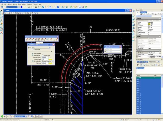
11 Slide 10 Interpretation and Conversion Automatic and interactive modes to create topologically ready linework. Raster Snap Convert contours and automatically assign elevations Convert all connected lines or just an area Erase raster while vectorizing Optical Character Recognition with foreign language support Raster symbol recognition and replacement Bentley Descartes provides rapid interpretation and raster-to-vector conversion by providing fingertip control over all editing functions. It expedites work, saving time and money with a robust set of tools including cleanup, vectorization, and Optical Character Recognition. These easy-to-use conversion tools ensure raster-to-vector conversion is performed with accuracy and efficiency. Descartes can also isolate a color and extract the associated features through line following or heads-up digitizing at survey level accuracy for input to engineering processes. Preserve and exploit your existing scanned documents and drawings by converting them to MicroStation with Bentley Descartes.
12 Slide 11
13 Slide 12 Precision Mapping and Engineering High fidelity imaging with MicroStation accuracy Raster as DGN elements, DWG is also supported Seamless integration Bentley Descartes provides high-fidelity imaging to support precision mapping and engineering by enabling you to combine imagery in virtually any format and projection with the precision mapping capabilities of MicroStation. Bentley Descartes gives you an unparalleled level of integration for raster data. Bentley Descartes takes full advantage of the geometric accuracy of the MicroStation environment so you can leverage images for survey quality mapping and precision engineering. The seamless integration of Bentley Descartes with MicroStation avoids dual working environments for raster and vector information.

14 Slide 13 Alexandra Park Restoration, Oldham Metropolitan B.C. Bentley Descartes was used on this project which authentically replicated or restored original structures that once stood on the site and enhanced the rich municipal heritage by creating new paths, bridges, improved landscaping and infrastructure.
15 Slide 14 Flexible Image Manipulation Translate, scale, rotate, crop, move, merge and more Clipping and cropping non-rectangular shapes Transparency and translucency support WYSIWYG enhancement tools Work with images as elements Selection set operations Bentley Descartes includes tools to crop, copy, move, merge, scale, mirror, square, and rotate images or objects within images, as well as tools to make regions of images translucent or transparent. These interactive tools provide dynamic feedback, making image manipulation intuitive and efficient. Clip raster to reveal what lies beneath, or clip raster to a polygon shape. You can work with single images, or apply an operation to a selection set of images. Cut or copy a section of an image to another area taking advantage of the Color Mask tools to selectively refine the operation by color. Use these capabilities to automate production of montages, corridor and plan sheet alignments, or to lay out plots or documents. Use the extensive Descartes API to gain maximum productivity through automating repeatable workflows that can be executed in batch or customizing the interactive environment to your specific needs.
16 Slide 15
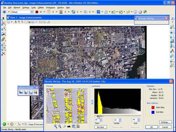
17 Slide 16 Cleanup, Editing, and Enhancement Automated despeckling and interactive cleanup tools Cleanup masks specify which colors are modified Rich set of raster editing and touch-up tools Clean up scanned legacy drawings for conversion or restoration Clean-up drawings by filling in holes and reduce noise by de-speckling. The cleanup tools can be applied to a specified area of the image and be used with colour masks. Rapidly improve the quality of poor source drawings in order to take advantage of automated conversion tools or quickly restore and enhance legacy drawings to prolong their life. Bentley Descartes also provides a rich set of tools to edit images. Touch-up tools make it easy to remove unwanted pixels in an image or improve the quality of raster linework. Simple but powerful brushing tools can be used to paint or edit selected portions of an image with brushes that filter to specific target colors. Rapidly improve the quality of poor source drawings in order to take advantage of automated conversion tools or quickly restore and enhance legacy drawings to prolong their life.
18 Slide 17
19 Slide 18 Georeferencing and Registration WYSIWYG Image Registration Dynamic warping with preview before resampling the image Vector data can also be transformed No residuals warping feature Descartes unique WYSIWYG image registration is much more intuitive than other approaches that require distinct windows for vector and image data and that rely heavily upon transformational statistics. Register provides for dynamic warping which overlays vector data over the uncorrected image so you can verify the transformation model before resampling the image. It also provides for transformation of vector data through the same model and batch resampling of images.

20 Slide 19 Precision registration is designed for production efficiency.
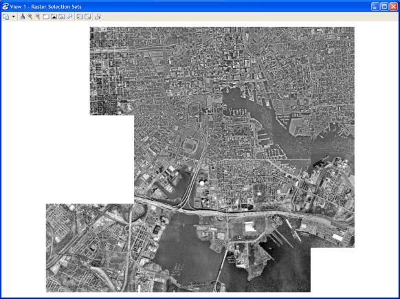
21 Slide 20 Seamless Image Mosaics Rapidly mosaic multiple images Tone balancing Seam definition and feathering Images can be combined into one image or remain separate Capitalize on the high performance display engine and the capabilities of Bentley Descartes to create seamless mosaics of multiple images, scanned aerial photos, or adjacent raster scanned images to see the complete picture for use in your business processes. Choose to leave the source images in their original form to produce a mosaic or create an easily transportable mosaic all in one file. Several images can be done at once, and the process is swift, interactive and can be completed in minutes!
22 Slide 21
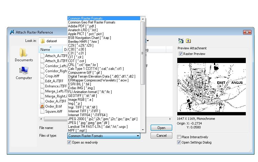
23 Slide 22 Native Support for Industry Formats Built on high-speed MicroStation Raster Manager Cache system ensures high performance for all image formats Formats are supported natively no conversion required to begin work Ability to convert images to any supported format Georeferencing information inherent in image is used for automatic placement Bentley Descartes provides support for a wide variety of industry-standard image formats. Native binary, grayscale, and color image formats (1, 4, 8, 11 and 24, 48, and 64 bits). All formats are implemented natively for optimal performance. Open and Save operations are done without additional conversion. Likewise, files can easily be converted to any supported format, providing flexibility to address internal standards and to support exchange with other systems.
24 Slide 23
25 Slide 24 ProjectWise Integration idesktop Integration Raster attachment and world files Check/Copy Out control from Raster Manager GUI Controlled Auto-Check-in/out Reference Out New technology allowing raster files to be streamed out instead of totally copied out Saves Time and Disks Space All Bentley Descartes V8 XM Edition features for opening or creating a file can now access either a ProjectWise folder or a local folder. As an example, you can use the Corridor tool with images from a local hard disc and output the Corridor image to ProjectWise. Bentley Descartes editing features will verify the state of the image and will function only if the image is "Checked Out". To check out an opened image, simply remove the check mark from the Read-Only column in the Raster Manager dialog box. This integration is available throughout the Bentley Descartes application.
26 Slide 25
27 Slide 26 What s new in Bentley Descartes V8i Enhanced Merge Tool Editing 3D Oriented Rasters Binary File Enhancements Dynamic Raster Snap Local Transform Tools Vectorize Enhancements Copy/Paste integrated with the Windows Clipboard Resample a Raster to Another Coordinate System New Filters 26
28 Slide 27 Benefits of Bentley Descartes Integrate imagery to facilitate the best decisions. Accelerate Project Approval and funding with professional presentation images, animations, and fly-through. Expedite work with rapid image interpretation and enhancement and conversion. Exploit existing scanned documents by converting them to MicroStation using cleanup, vectorization, and OCR tools. Combine imagery in virtually any format and projection with the precision mapping capabilities of MicroStation and Bentley s Geospatial applications.
29 Slide 28 Benefits of Bentley Descartes Seamless integration with MicroStation avoids dual working environments and takes advantage of existing MicroStation skills. DWG with raster is also supported. Rapidly create seamless mosaics to see the complete picture for use in your business processes. Combine imagery with existing vector data and use the tools provided in Bentley s geospatial products for precision mapping and engineering. Use visualization for to execute situation analysis and planning for defense and industrial operations. Use the Descartes API to automate repeatable workflows, batch or interactive.
30 Thank you. Slide 29
GE1LC7 - Getting to Know Bentley Descartes for Advanced Image Viewing, Editing and Processing
 GE1LC7 - Getting to Know Bentley Descartes for Advanced Image Viewing, Editing and Processing Inga Morozoff Introduction: Raster data is everywhere - whether you do CAD design, mapping or GIS analysis,
2011 Bentley Systems, Incorporated. Bentley Descartes V8i Advancing Information Modeling For Intelligent Infrastructure
 Bentley Descartes V8i Advancing Information Modeling For Intelligent Infrastructure Agenda Why would you need Bentley Descartes? What is Bentley Descartes? Advanced Point Cloud Workflows Advanced Terrain
Bentley Descartes and what s new in Descartes V8i (SELECTseries 3) What is Bentley Descartes? 2011 Bentley Systems, Incorporated
 What is Bentley Descartes? 2011 Bentley Systems, Incorporated") Bentley Descartes and what s new in Descartes V8i (SELECTseries 3) Tom Stogdill Bentley Systems, Inc. What is Bentley Descartes? Image Processing Raster Geo-Referencing Advanced raster transformation (warping,
Bentley Descartes and what s new in Descartes V8i (SELECTseries 3) Tom Stogdill Bentley Systems, Inc. What is Bentley Descartes? Image Processing Raster Geo-Referencing Advanced raster transformation (warping,
2011 Bentley Systems, Incorporated. Bentley Descartes V8i (SELECTseries 3) Advancing Information Modeling For Intelligent Infrastructure
 Advancing Information Modeling For Intelligent Infrastructure") Bentley Descartes V8i (SELECTseries 3) Advancing Information Modeling For Intelligent Infrastructure What is Bentley Descartes? Image Processing Raster Geo-Referencing Advanced raster transformation (warping,
Bentley Descartes V8i (SELECTseries 3) Advancing Information Modeling For Intelligent Infrastructure What is Bentley Descartes? Image Processing Raster Geo-Referencing Advanced raster transformation (warping,
M c i r c os o t S at a io i n o n an a d n d A lll lth T i h n i g n s g s P D P F Agenda
 MicroStation and All Things PDF Agenda Basic PDF Creation from within MicroStation PDF Printer Drivers Printing 3D Design Geometry to a PDF File Sending Geospatial Data to a PDF Exporting Business Data
Questions and Answers
 Autodesk AutoCAD Raster Design 2011 Questions and Answers AutoCAD Raster Design 2011 Questions and Answers Make the most of rasterized scanned drawings, maps, aerial photos, satellite imagery, and digital
MicroStation Descartes User s Guide Table of Contents
 MicroStation Descartes User s Guide Table of Contents 1. Introduction About This Guide 1-1 Before You Begin 1-2 2. MicroStation Descartes Overview 3. Fundamentals How to Start MicroStation Descartes 3-1
Point Cloud Processing and Large Scalable Terrain Model Extraction Inga Morozoff
 Point Cloud Processing and Large Scalable Terrain Model Extraction Inga Morozoff 1 Point cloud data is a new data type that s being driven by the need for accurate 3D as-built information. Point cloud
MicroStation XM/V8i/SS1
 MicroStation XM/V8i/SS1 1 By Rande Robinson THE LEGAL STUFF (The stuff my bosses make me add.) 2 The Opinions (no matter how well thought out they are) expressed in this presentation are my own and do
Introducing ArcScan for ArcGIS
 Introducing ArcScan for ArcGIS An ESRI White Paper August 2003 ESRI 380 New York St., Redlands, CA 92373-8100, USA TEL 909-793-2853 FAX 909-793-5953 E-MAIL info@esri.com WEB www.esri.com Copyright 2003
ArcGIS Pro Editing. Jennifer Cadkin & Phil Sanchez
 ArcGIS Pro Editing Jennifer Cadkin & Phil Sanchez ArcGIS Pro Editing Overview Provides tools that allow you to maintain, update, and create new data - Modifying geometry, drawing new features - Entering
Feature Enhancements by Release
 Autodesk Map Feature Enhancements by Release This document highlights the feature enhancements that have occurred with each release of Autodesk Map software from Release 4 (2000i) through the current 2004
SkylineGlobe 6.5 s New Developments
 SkylineGlobe 6.5 s New Developments The SkylineGlobe Enterprise suite of applications was created to provide all of the necessary software tools for an organization to implement their own private, 3D virtual
2010 Bentley Systems, Incorporated Exploring MicroStation V8i Printing. Jo Terri Wright Product Manager Collaboration Products
 Exploring MicroStation V8i Printing Jo Terri Wright Product Manager Collaboration Products Agenda Unification of Bentley Print clients Print Organizer Features Common Print Features SELECTseries Enhancements
Features and Benefits
 CAiCE Visual Survey 10 Features and Benefits CAiCE Visual Survey 10 software enables surveying professionals to import, process, analyze, and present surveying all in one software package. Visual Survey
Intelligent photogrammetry. Agisoft
 Intelligent photogrammetry Agisoft Agisoft Metashape is a cutting edge software solution, with its engine core driving photogrammetry to its ultimate limits, while the whole system is designed to deliver
Mosaic Tutorial: Advanced Workflow
 Mosaic Tutorial: Advanced Workflow This tutorial demonstrates how to mosaic two scenes with different color variations. You will learn how to: Reorder the display of the input scenes Achieve a consistent
ArcGIS Pro Editing: An Introduction. Jennifer Cadkin & Phil Sanchez
 ArcGIS Pro Editing: An Introduction Jennifer Cadkin & Phil Sanchez See Us Here WORKSHOP ArcGIS Pro Editing: An Introduction LOCATION SDCC - Ballroom 20 D TIME FRAME Thursday 10:00 11:00 ArcGIS Pro: 3D
By Colin Childs, ESRI Education Services. Catalog
 s resolve many traditional raster management issues By Colin Childs, ESRI Education Services Source images ArcGIS 10 introduces Catalog Mosaicked images Sources, mosaic methods, and functions are used
IMAGINE EXPANSION PACK Extend the Power of ERDAS IMAGINE
 IMAGINE EXPANSION PACK Extend the Power of ERDAS IMAGINE IMAGINE EXPANSION PACK IMAGINE Expansion Pack is a collection of functionality to extend the utility of ERDAS IMAGINE. It includes 3D visualization
3D Terrain Modelling of the Amyntaio Ptolemais Basin
 2nd International Workshop in Geoenvironment and 1 3D Terrain Modelling of the Amyntaio Ptolemais Basin G. Argyris, I. Kapageridis and A. Triantafyllou Department of Geotechnology and Environmental Engineering,
PhotoScan. Fully automated professional photogrammetric kit
 PhotoScan Fully automated professional photogrammetric kit Agisoft PhotoScan is a stand-alone photogrammetric software solution for automatic generation of dense point clouds, textured polygonal models,
Disc I: (2:51:00) Disc II: (2:34:00) Part I: Intro/Environment. Part III: Tools. Part II: Selection Tools, Basic Editing & Layers.
 Disc II: (2:34:00) Part I: Intro/Environment. Part III: Tools. Part II: Selection Tools, Basic Editing & Layers.") Disc I: (2:51:00) Disc II: (2:34:00) Part I: /Environment Part III: Tools 21:59 Stamp Tools 6:21 Environment 24:22 Color Management Profiles Color # s Custom Colors Back to settings Edit: Preferences 5:57
Disc I: (2:51:00) Disc II: (2:34:00) Part I: /Environment Part III: Tools 21:59 Stamp Tools 6:21 Environment 24:22 Color Management Profiles Color # s Custom Colors Back to settings Edit: Preferences 5:57
Integrating CAD Data with ArcGIS
 Integrating CAD Data with ArcGIS Agenda An Overview of CAD Drawings CAD Data Structure in ArcGIS Visualization Georeferencing Data Conversion ArcGIS for AutoCAD Q & A CAD Drawings - Overview Widely used
PRODUCT BROCHURE IMAGESTATION HIGH VOLUME PHOTOGRAMMETRY AND PRODUCTION MAPPING
 PRODUCT BROCHURE IMAGESTATION HIGH VOLUME PHOTOGRAMMETRY AND PRODUCTION MAPPING UNPARALLELED PROCESSING, ACCURATE RESULTS FOR CAD AND GIS-BASED WORKFLOWS The ImageStation software suite enables digital
GSSHA WMS Basics Loading DEMs, Contour Options, Images, and Projection Systems
 v. 10.0 WMS 10.0 Tutorial GSSHA WMS Basics Loading DEMs, Contour Options, Images, and Projection Systems Learn how to work with DEMs and images and to convert between projection systems in the WMS interface
13 Vectorizing. Overview
 13 Vectorizing Vectorizing tools are used to create vector data from scanned drawings or images. Combined with the display speed of Image Manager, these tools provide an efficient environment for data
Suite en It Up with Autodesk ReCap
 Chad Studer ADSK Solutions RC3165 Static and mobile laser scanning technologies capture millions of points and provide photorealistic interactive virtual sites known as point clouds. With Autodesk ReCap
PhotoScan. Fully automated professional photogrammetric kit
 PhotoScan Fully automated professional photogrammetric kit Agisoft PhotoScan is a stand-alone photogrammetric software solution for automatic generation of dense point clouds, textured polygonal models,
DIS: Design and imaging software
 Using IT productivity tools and applications This is the ability to use a software application designed to create, modify and layout artwork or images for display in print or on a screen (eg vector graphics
IMAGINE Objective. The Future of Feature Extraction, Update & Change Mapping
 IMAGINE ive The Future of Feature Extraction, Update & Change Mapping IMAGINE ive provides object based multi-scale image classification and feature extraction capabilities to reliably build and maintain
Managing Image Data on the ArcGIS Platform Options and Recommended Approaches
 Managing Image Data on the ArcGIS Platform Options and Recommended Approaches Peter Becker Petroleum requirements for imagery and raster Traditional solutions and issues Overview of ArcGIS imaging capabilities
What s New in ecognition 9.0
 What s New in ecognition 9.0 Dr. Waldemar Krebs tranforming data into GIS ready information Trends in Earth Observation Increasing need for detailed, up-to-date information as a basis for planning and
Surveying like never before
 CAD functionalities GCP Mapping and Aerial Image Processing Software for Land Surveying Specialists Surveying like never before www.3dsurvey.si Modri Planet d.o.o., Distributors: info@3dsurvey.si +386
BIM in infrastructure case study: Swedish road projects vägplan
 BIM in infrastructure case study: Swedish road projects vägplan Mateusz Nettmann Moving Poland s construction industry into the future with BIM (BIM Event BPCC) January, 11, 2018 AGENDA Introduction: AECOM
CREATING CUSTOMIZED SPATIAL MODELS WITH POINT CLOUDS USING SPATIAL MODELER OPERATORS TO PROCESS POINT CLOUDS IN IMAGINE 2014
 CREATING CUSTOMIZED SPATIAL MODELS WITH POINT CLOUDS USING SPATIAL MODELER OPERATORS TO PROCESS POINT CLOUDS IN IMAGINE 2014 White Paper December 22, 2016 Contents 1. Introduction... 3 2. ERDAS IMAGINE
ProjectWise for Civil Users
 ProjectWise for Civil Users Arbie Parker, Services Consultant, ProjectWise arbie.parker@bentley.com 1 WWW.BENTLEY.COM 2016 Bentley Systems, Incorporated 2016 Bentley Systems, Incorporated Changes to Civil
Innovation. lidarnews.com. volume 3 issue 5. Points clouds and terrain models support rail project. Structured light scanning for human head modeling
 volume 3 issue 5 LIDAR lidarnews.com SCALABILITY Points clouds and terrain models support rail project EXPRESSION Structured light scanning for human head modeling FLUCTUATION Scanning moving objects using
How to use. Home page
 Home page Double click WebCam Companion 3 to launch the application, the home page appears with 4 main features: Capture, Edit, Annotation and E-book. 11 1 Home page The Extras menu gives you access to
Georeferencing in ArcGIS
 Georeferencing in ArcGIS Georeferencing In order to position images on the surface of the earth, they need to be georeferenced. Images are georeferenced by linking unreferenced features in the image with
What's New in NX 11 for Design Engineering
 What's New in NX 11 for Design Engineering NX 11 for Design Productivity Convergent Modeling Many industries use scanned 3D data as part of their design processes. If you have worked with this data in
UTILIZACIÓN DE DATOS LIDAR Y SU INTEGRACIÓN CON SISTEMAS DE INFORMACIÓN GEOGRÁFICA
 UTILIZACIÓN DE DATOS LIDAR Y SU INTEGRACIÓN CON SISTEMAS DE INFORMACIÓN GEOGRÁFICA Aurelio Castro Cesar Piovanetti Geographic Mapping Technologies Corp. (GMT) Consultores en GIS info@gmtgis.com Geographic
Creative Web Designer Course
 Creative Web Designer Course Photoshop 1. Getting to Know the Work Area Starting to work in Adobe Photoshop Using the tools Setting tool properties Undoing actions in Photoshop More about panels and panel
Imagery and Raster Data in ArcGIS. Abhilash and Abhijit
 Imagery and Raster Data in ArcGIS Abhilash and Abhijit Agenda Imagery in ArcGIS Mosaic datasets Raster processing ArcGIS is a Comprehensive Imagery System Integrating All Types, Sources, and Sensor Models
What s New in ecognition 9.0. Christian Weise
 What s New in ecognition 9.0 Christian Weise Presenting ecognition 9 Release Date: March 2014 Who s eligible? All user with a valid ecognition maintenance contract Presenting ecognition 9 ecognition version
The Number 1 In Raster / Vector Processing ForOver10Years. Overview and Specifications.
 The Number 1 In Raster / Vector Processing ForOver10Years Overview and Specifications www.softelec.com VPHybridCAD world s No. 1 in hybrid CAD represents a line of internationally awarded software products,
Unveiling ProjectWise Navigator V8i The Information Rich Review Alternative
 Unveiling ProjectWise Navigator V8i The Information Rich Review Alternative Tony DeRosa Interoperability Priorities Reusable and Complete Information Exchange rich heterogeneous information Rely upon secure
2/9/2016. Session Agenda: Implementing new Geospatial Technologies for more efficient data capture
 Implementing new Geospatial Technologies for more efficient data capture Jay Haskamp Applied Geospatial Engineer Steve Richter VP Sales Session Agenda: Today s changing technologies and what lies ahead
Technology for Cadastral Applications. John R. Hacker, Jr. Marketing Manager Geospatial Applications
 Technology for Cadastral Applications John R. Hacker, Jr. Marketing Manager Geospatial Applications Agenda Cadastral Mapping Issues Precision and Accuracy Data Creation Data Management Data Publishing
Questions and Answers
 AutoCAD Raster Design 2008 Questions and Answers 1. General Product Information 1.1 What is AutoCAD Raster Design 2008? AutoCAD Raster Design 2008 software is the leading raster application for design
Visualizing 2D Data in a 3D World
 Visualizing 2D Data in a 3D World Karl Kliparchuk, M.Sc., GISP, and Brendan Walashek, B.Sc. McElhanney Consulting Services Ltd. Email: kkliparchuk@mcelhanney.com and bwalashek@mcelhanney.com Agenda A Quick
Geospatial Engineering Problems & Solutions Associated With NDP Roads, Tunnelling & Civil Engineering Projects Use of HDS Leica Laser Scanners
 Geospatial Engineering Problems & Solutions Associated With NDP Roads, Tunnelling & Civil Engineering Projects Use of HDS Leica Laser Scanners Laser Scanning Laser Scanning is a method of collecting large
ArcScan. for ArcGIS. GIS by ESRI
 ArcScan for ArcGIS GIS by ESRI Copyright 2002 ESRI All rights reserved Printed in the United States of America The information contained in this document is the exclusive property of ESRI This work is
What s New in Imagery in ArcGIS. Presented by: Christopher Patterson Date: September 12, 2017
 What s New in Imagery in ArcGIS Presented by: Christopher Patterson Date: September 12, 2017 Agenda Ortho Mapping Elevation extraction Drone2Map Raster Analytics ArcGIS is a Comprehensive Imagery System
Organizing Design Data
 Organizing Design Data Module Overview This module explains how to use the data in different files for reference purposes. Module Prerequisites Knowledge of MicroStation s interface Some knowledge about
DjVu Technology Primer
 DjVu Technology Primer NOVEMBER 2004 LIZARDTECH, INC. OVERVIEW LizardTech s Document Express products are powered by DjVu, a technology developed in the late 1990s by a team of researchers at AT&T Labs.
Raster Serving with ArcGIS
 Raster Serving with ArcGIS Agenda Introduction to server technology Workflow considerations ESRI raster serving technology ArcGIS Server Basic (ArcSDE) ArcGIS Server Standard/Advanced Web Services ArcGIS
EUROPEAN COMPUTER DRIVING LICENCE / INTERNATIONAL COMPUTER DRIVING LICENCE IMAGE EDITING
 EUROPEAN COMPUTER DRIVING LICENCE / INTERNATIONAL COMPUTER DRIVING LICENCE IMAGE EDITING The European Computer Driving Licence Foundation Ltd. Portview House Thorncastle Street Dublin 4 Ireland Tel: +
What s New in Imagery in ArcGIS. Presented by: Christopher Patterson Date: October 18, 2017
 What s New in Imagery in ArcGIS Presented by: Christopher Patterson Date: October 18, 2017 Imagery in ArcGIS Advancing 2010 Stretch, Extract Bands Clip, Mask Reproject, Orthorectify, Pan Sharpen Vegetation
OMNIWIN Advanced Designing and Nesting Software
 OMNIWIN 2016 Advanced Designing and Nesting Software OmniWin 2016 is the ideal software for thermal cutting for oxyfuel, plasma and laser cutting with CNC machines. It is first class software equipped
button in the lower-left corner of the panel if you have further questions throughout this tutorial.
 Mosaic Tutorial: Simple Workflow This tutorial demonstrates how to use the Seamless Mosaic tool to mosaic six overlapping digital aerial scenes. You will learn about displaying footprints and image data
Import, view, edit, convert, and digitize triangulated irregular networks
 v. 10.1 WMS 10.1 Tutorial Import, view, edit, convert, and digitize triangulated irregular networks Objectives Import survey data in an XYZ format. Digitize elevation points using contour imagery. Edit
Modelling. Ruth Aylett
 Modelling Ruth Aylett Overview Basic issues Modelling packages Low polygon modelling Importing models Buildings Photogrammetry Laser range finders LIDAR The great outdoors Cheap methods 3D Authoring tools
TrueOrtho with 3D Feature Extraction
 TrueOrtho with 3D Feature Extraction PCI Geomatics has entered into a partnership with IAVO to distribute its 3D Feature Extraction (3DFE) software. This software package compliments the TrueOrtho workflow
Reality Modeling Webinar
 Reality Modeling Webinar Leveraging 3D Reality Meshes for Real-Time Asset Management and Monitoring What is Reality Modeling? Images & video? What is Reality Modeling? Images & video As-built drawings
Go From Paper to Automated PDFs and Purpose-built Models
 Go From Paper to Automated PDFs and Purpose-built Models ProjectWise Learn Conference Hans Koorneef, Technical Director EMEA Bentley Systems 1 WWW.BENTLEY.COM 2017 Bentley Systems, Incorporated Agenda
Artipic 2.2 Release Announcement
 Incredible images, quickly and easily! November 10, 2014. The Artipic Team is happy to announce the release of Artipic 2.2! Artipic, a state-of-the-art image editing system providing a rich set of tools,
MicroStation Tips and Tricks. Inga Morozoff, Bentley Systems, Inc Bentley Systems, Incorporated.
 MicroStation Tips and Tricks Inga Morozoff, Bentley Systems, Inc. 1 Add Separator to Context Menu To add a separator to a context menu, create a new menu item and set the label as a hyphen. ALT+DATA to
SkylineGlobe - Products Overview
 SkylineGlobe - Products Overview Skyline Software Systems, Inc. is a leading provider of 3D earth visualization software and services. The company offers a comprehensive platform of applications, tools
Chapter 1 Introduction to Photoshop CS3 1. Exploring the New Interface Opening an Existing File... 24
 CONTENTS Chapter 1 Introduction to Photoshop CS3 1 Exploring the New Interface... 4 Title Bar...4 Menu Bar...5 Options Bar...5 Document Window...6 The Toolbox...7 All New Tabbed Palettes...18 Opening an
SOLIDWORKS TECHNICAL COMMUNICATIONS
 SOLIDWORKS TECHNICAL COMMUNICATIONS ADDING INNOVATION TO YOUR TECHNICAL COMMUNICATION DELIVERABLES POWERFUL, YET SIMPLE SOLUTIONS TO HELP YOU GROW YOUR BUSINESS You put significant time and money into
SkylineGlobe Web Package Version 6.1 Release Notes
 SkylineGlobe Web Package Version 6.1 Release Notes Information contained in this document is subject to change without notice and does not represent a commitment on behalf of Skyline Software Systems Inc.
Managing Imagery and Raster Data Using Mosaic Datasets
 2013 Esri International User Conference July 8 12, 2013 San Diego, California Technical Workshop Managing Imagery and Raster Data Using Mosaic Datasets Hong Xu, Prashant Mangtani Esri UC2013. Technical
Introduction to the Image Analyst Extension. Mike Muller, Vinay Viswambharan
 Introduction to the Image Analyst Extension Mike Muller, Vinay Viswambharan What is the Image Analyst Extension? The Image Analyst Extension (IA) is an application extension which extends ArcGIS Pro with
HybridCAD RASTER AND VECTOR UNITED. For 15 Years the No.1 in Raster-Vector Technology. V9 Products and Specifications
 HybridCAD V9 Products and Specifications For 15 Years the No.1 in Raster-Vector Technology HybridCAD VPHybridCAD Series lite Strong on Small Formats: Black & White Auto-Vectorization up to A2 (C Size)
GREENBOOK GEOPAK IN A PROJECTWISE ENVIRONMENT. ProjectWise Integration Server GEOPAK Civil Collaboration. communities.bentley.
 GEOPAK IN A PROJECTWISE ENVIRONMENT ProjectWise Integration Server GEOPAK Civil Collaboration www.bentley.com communities.bentley.com First Edition (May 2010) Applies to: ProjectWise V8 XM Edition 8.09.04.131
New! Analysis Ready Data Tools Add-on package for image preprocessing for multi-temporal analysis. Example of satellite imagery time series of Canada
 Highlights New! Analysis Ready Data Tools Add-on package for image preprocessing for multi-temporal analysis Rigorous scientific preprocessing Example of satellite imagery time series of Canada A new industry
ERDAS IMAGINE THE WORLD S MOST WIDELY-USED REMOTE SENSING SOFTWARE PACKAGE
 PRODUCT BROCHURE ERDAS IMAGINE THE WORLD S MOST WIDELY-USED REMOTE SENSING SOFTWARE PACKAGE 1 ERDAS IMAGINE The world s most widely-used remote sensing software package 2 ERDAS IMAGINE The world s most
Alaska Department of Transportation Roads to Resources Project LiDAR & Imagery Quality Assurance Report Juneau Access South Corridor
 Alaska Department of Transportation Roads to Resources Project LiDAR & Imagery Quality Assurance Report Juneau Access South Corridor Written by Rick Guritz Alaska Satellite Facility Nov. 24, 2015 Contents
Critical Essentials. Overview. Objectives. Recommended Prior Skills. Upon completion of these topics, you should be able to:
 Critical Essentials Visualizing spaces in three dimensions is critical to the success of the design of architectural spaces. The interplay of light, color, and space are critical concepts to master. Traditional
character design pipeline) callum.html
 callum.html") References: http://3d.about.com/od/3d-101-the-basics/tp/introducing-the-computer-graphics- Pipeline.htm (character design pipeline) http://cpapworthpp.blogspot.co.uk/2012/12/animation-production-pipelinecallum.html
References: http://3d.about.com/od/3d-101-the-basics/tp/introducing-the-computer-graphics- Pipeline.htm (character design pipeline) http://cpapworthpp.blogspot.co.uk/2012/12/animation-production-pipelinecallum.html
Mike Horsfall Technical Manager GeoSpatial Sales
 An Introduction to Bentley Utilities Designer Mike Horsfall Technical Manager GeoSpatial Sales What is Bentley Utilities Designer? Bentley Utilities Designer is: A multi-utilities desktop GIS Built on
TerraScan Tool Guide
 TerraScan Main Toolbox General Toolbar Draw Toolbar Groups Toolbar Vectorize Towers Toolbar Road Toolbar Buildings Toolbar Building Edges Toolbar View Laser Toolbar Model Toolbar Vectorize Wires Toolbar
Making Topographic Maps
 T O P O Applications N Making Topographic Maps M A P S Making Topographic Maps with TNTmips page 1 Before Getting Started TNTmips provides a variety of tools for working with map data and making topographic
Adobe Photoshop cs2. The professional standard in desktop digital imaging
 Adobe Photoshop cs2 The professional standard in desktop digital imaging Product overview Adobe Photoshop CS2 software, the professional image-editing standard and leader of the Photoshop digital imaging
GstarCAD 2018 Complete Features Guide
 0 GstarCAD 2018 Complete Features Guide 1. Performance optimization... 4 1.1 Common File Operation... 4 1.2 Common Editing Operation... 4 2. Editing Functions Optimization... 5 2.1 Array Options New...
BROWSER. LuciadRIA DATA SHEET
 BROWSER LuciadRIA DATA SHEET V2017 V2017.0 DATA SHEET LuciadRIA is the answer to today s demands for powerful, lightweight applications in the browser. Driven by today s most advanced web technologies,
Virginia Western Community College ARC 221 Architectural CAD Applications Software I
 Virginia Western Community College ARC 221 Architectural CAD Applications Software I Prerequisites CAD 241 Course Description Teaches the principles and techniques of architectural drawing practices through
ENVI Automated Image Registration Solutions
 ENVI Automated Image Registration Solutions Xiaoying Jin Harris Corporation Table of Contents Introduction... 3 Overview... 4 Image Registration Engine... 6 Image Registration Workflow... 8 Technical Guide...
ArcView QuickStart Guide. Contents. The ArcView Screen. Elements of an ArcView Project. Creating an ArcView Project. Adding Themes to Views
 ArcView QuickStart Guide Page 1 ArcView QuickStart Guide Contents The ArcView Screen Elements of an ArcView Project Creating an ArcView Project Adding Themes to Views Zoom and Pan Tools Querying Themes
Bentley OpenRoads Workshop 2017 FLUG Fall Training Event
 Bentley OpenRoads Workshop 2017 FLUG Fall Training Event F-2P - QuickStart for Roadway Modeling in OpenRoads Technology Bentley Systems, Incorporated 685 Stockton Drive Exton, PA 19341 www.bentley.com
Semi-Automated and Interactive Construction of 3D Urban Terrains
 Semi-Automated and Interactive Construction of 3D Urban Terrains Tony Wasilewski *, Nickolas Faust, and William Ribarsky Center for GIS and Spatial Analysis Technologies Graphics, Visualization, and Usability
version Adobe After Effects 5.0 An Overview of Adobe After Effects Superior Adobe product integration
 Macintosh OS 9.0.4/Windows 98/2000/NT/Windows ME version Adobe After Effects 5.0 An Overview of Adobe After Effects This overview introduces you to the key features of After Effects. If you re an experienced
Using Autodesk Map Capabilities in Autodesk Civil 3D
 11/30/2005-1:00 pm - 2:30 pm Room:Swan 2 (Swan) Walt Disney World Swan and Dolphin Resort Orlando, Florida Using Autodesk Map Capabilities in Autodesk Civil 3D Neil Brooker - Autodesk CV33-3 This class
Creating Printed Output
 Creating Printed Output Module Overview This module will help you to become familiar with the options that let you produce quality printed output. Module Prerequisites Fundamental knowledge of the Microsoft
Bentley BASH MicroStation V8i SS2 User Update. Morning Session with Sam Hendrick
 Bentley BASH 2011 MicroStation V8i SS2 User Update Morning Session with Sam Hendrick sam.hendrick@bentley.com www.scbug.com User Interface Update Agenda Overview Navigate the application window layout
ADOBE 9A Adobe Illustrator CS ACE. Download Full Version :
 ADOBE 9A0-035 Adobe Illustrator CS ACE Download Full Version : https://killexams.com/pass4sure/exam-detail/9a0-035 QUESTION: 121 You want to set crop marks directly in your artwork and specify a user defined
Upgrade Matrix. Feature. Accessing Design Assets. User Interface NEW! NEW! NEW! NEW! ENHANCED!
 Accessing Design Assets Built-in content organizer Speed up your workflow with Corel CONNECT, which instantly finds graphics, templates, fonts and images on your computer. Blank Document/Image presets
Editing in Premiere Pro CC 2015
 Editing in Premiere Pro CC 2015 Lesson 1: Exploring the Interface Exploring the Interface The Source Window The Program Window The Settings Menu Revealing the Video Scopes The Workspace Bar The Project
RELEASE NOTES FOR TERRAEXPLORER FOR WEB 7.1
 RELEASE NOTES FOR TERRAEXPLORER FOR WEB 7.1 About TerraExplorer for Web TerraExplorer for Web (TE4W) is a lightweight 3D GIS viewer that seamlessly accesses online data from Skyline s SkylineGlobe Server,