ProjectWise for Civil Users
|
|
|
- Ashlyn Bryant
- 6 years ago
- Views:
Transcription

1 ProjectWise for Civil Users Arbie Parker, Services Consultant, ProjectWise Bentley Systems, Incorporated 2016 Bentley Systems, Incorporated

2 Changes to Civil tools Legacy data files alg - Bentley InRoads Geometry Projects dtm - Bentley InRoads Surfaces rwk - Bentley InRoads Project sdb - Bentley InRoads Drainage dft - Bentley InRoads Drafting Notes itl - Bentley InRoads Template Libraries ird - Bentley InRoads Roadway Design xin - Bentley InRoads Preference Legacy Dialog boxes: Bentley Systems, Incorporated

3 Open Roads Technology OpenRoads enables the project delivery of road networks through constructiondriven engineering and delivers all the information needed to support operational worfklows. OpenRoads applications help redefine best practices for design and construction deliverables supporting the exchange of information throughout the project delivery lifecycle, to all participants of the project delivery team Bentley Systems, Incorporated

4 MicroStation interface based Tools are based in MS task interface, no longer a separate dialog box Tools>tasks>civil tools The Civil data is in the dgn file. Allows the user to interactively edit and manipulate the data Data files are now part of the DGN. There is no need for the separate files. It s stored as part of the DGN. Allow for more dynamic interaction with a 3D model Bentley Systems, Incorporated
5 MicroStation interface based, cont d MicroStation based standards (dgn libraries) With ProjectWise Integration, dgnlibs are managed via workspace SINGLE FILE VS. MULTIPLE FILES Situation: Do I need to do keep all the data from my project in a single file or can I use reference files? RECOMMENDATIONS You can keep all your data in a single file, which may be prudent if you have a very small project. However, if you have multiple users or a larger project, or you prefer granularity in your data, the use of reference files is encouraged Bentley Systems, Incorporated
 to the left of an item indicates additional information in the tree. 6 WWW.BENTLEY.")
6 Project Explorer in MicroStation The Civil Model Panel contains a list of all the Civil Data contained in the design file and is the primary navigable view of the Civil Model Any design files attached to this design file also appears in the tree view. When present a plus (+) to the left of an item indicates additional information in the tree Bentley Systems, Incorporated

7 Project Explorer in MicroStation The Civil Standards pane is used to manage the features, Civil Cells, design standards, graphic filters and project settings accessible from within the active design model Bentley Systems, Incorporated


8 ProjectWise Integration When an InRoads product is running integrated with ProjectWise, all file operations will respond to ProjectWise first. This means that any command that needs to open or save a file will let the user have the opportunity to go to ProjectWise for that operation Bentley Systems, Incorporated

9 Migrating from legacy data to Open Roads technology Bentley Systems, Incorporated 2016 Bentley Systems, Incorporated


10 Create Terrain Model from file integrated with ProjectWise Bentley Systems, Incorporated


11 Import Geometry Bentley Systems, Incorporated

12 Create Corridor template Bentley Systems, Incorporated


13 Import Corridor Bentley Systems, Incorporated

14 Corridor ProjectWise Managed Workspace Bentley Systems, Incorporated 2016 Bentley Systems, Incorporated


15 Import Existing Workspace Bentley Systems, Incorporated

16 ProjectWise Advanced integration with AutoCAD Civil 3D Bentley Systems, Incorporated 2016 Bentley Systems, Incorporated
17 For integration of Civil 3D with ProjectWise, integration deals with three primary areas Data Shortcut / Data Reference workflows Integration of the Prospector Tree Support for the creation of surfaces Bentley Systems, Incorporated


18 The.civildsproj file: The Civil 3D working folder without ProjectWise: Bentley Systems, Incorporated


19 The.civildsproj file: The Civil 3D working folder with ProjectWise: Bentley Systems, Incorporated


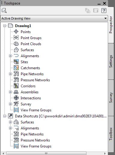
20 Bentley Systems, Incorporated Prospector Palate
21 Data Shortcut OPEN Mechanism CivilDSProj File Unzipped to XML Files Alignments Profiles Pipe networks Surfaces View frame groups Paths in XML Files are updated to the users specific working directory folder name Bentley Systems, Incorporated


22 Datashortcuts Project Editor Tool Graphical view of how the shortcuts are related to the source drawings Bentley Systems, Incorporated
23 Best Practices when working with data shortcuts Installing updates from AutoCAD has a tendency to break integration. Recommend to repair the integration module after applying updates Do not delete source dwg files from ProjectWise. The file gets deleted but the datashortcut still exists. This leads to the shortcut being not found in the prospector palate. Rename the original source location after import If Reference scan is run on the Data shortcut source files, Data shortcut.civildsproj file or files that have a companion file with a.mms or.grs the ProjectWise set will be lost. To correct this simply open the file in Civil 3D and the ProjectWise Integration will correct the Set (selfhealing). This behavior is due to the existing ref scan tool not being aware of Civil 3D sets Bentley Systems, Incorporated
24 Advantages of ProjectWise Integration Having the project data in a single secure location Documents and files have an auditable history Network latency issue resolved due to working folder being local to user s system Bentley Systems, Incorporated

25 ProjectWise and OpenRoads CONNECT Edition Bentley Systems, Incorporated 2016 Bentley Systems, Incorporated


26 CONNECTED Projects OpenRoads OpenBridge ProStructures gint LumenRT ProjectWise Bentley Systems, Incorporated


27 THANK YOU : Bentley ProjectWise Bentley Systems, Incorporated


28 Questions? Bentley Systems, Incorporated
ProjectWise Application Integration for Civil 3D
 BENTLEY SYSTEMS, INC. ProjectWise Application Integration for Civil 3D Frequently Asked Questions Prepared by Bentley Systems 12/3/2012 Version 1.0 ProjectWise and MicroStation are registered trademarks
ProjectWise and Civil 3D Advanced Integration
 ProjectWise and Civil 3D Advanced Integration Bobby Mullenax Solution Consultant 1 WWW.BENTLEY.COM 2017 Bentley Systems, Incorporated 2017 Bentley Systems, Incorporated Bobby Mullenax Contact Info Solution
Bentleyuser.dk Årsmøde 2012 Nordic Civil 2012
 Bentleyuser.dk Årsmøde 2012 Nordic Civil 2012 5.-7. November 2012, Munkebjerg Hotel, Vejle Workshop X7 Civil Design Review: 3D Modeling and Team Leader: Joe Waxmonsky, PE Bentley Systems, Incorporated
OpenRoads Creating Subsurface Utility Models
 OpenRoads Creating Subsurface Utility Models Existing and Proposed Utilities Presenter: Robert Garrett, PE Bentley Systems, Incorporated 685 Stockton Drive Exton, PA 19341 www.bentley.com Before you Begin:...
Overview September 7, 2017
 Overview September 7, 2017 Purpose The purpose of this presentation is to provide an overview of the changes to the required deliverables and workflow for developing plans and models for Illinois DOT projects
Bentley Civil Workshop
 Bentley Civil Workshop 2013 Bentley LEARNing Conference BCR4WK2 - IMPORTING AND EDITING SURVEY DATA Team Leader: Kevin Jackson Bentley Systems, Incorporated 685 Stockton Drive Exton, PA 19341 www.bentley.com
Enabling Work-in-Progress Project Sharing Between Teams Using ProjectWise Project Sharing
 Enabling Work-in-Progress Project Sharing Between Teams Using ProjectWise Project Sharing Arbie Parker, Services Consultant, Projectwise Arbie.Parker@bentley.com 1 WWW.BENTLEY.COM 2016 Bentley Systems,
ProjectWise and Revit Advanced Integration
 ProjectWise and Revit Advanced Integration Bobby Mullenax Solution Consultant 1 WWW.BENTLEY.COM 2017 Bentley Systems, Incorporated 2017 Bentley Systems, Incorporated Bobby Mullenax Contact Info Solution
Unveiling ProjectWise Navigator V8i The Information Rich Review Alternative
 Unveiling ProjectWise Navigator V8i The Information Rich Review Alternative Tony DeRosa Interoperability Priorities Reusable and Complete Information Exchange rich heterogeneous information Rely upon secure
Practice Workbook. Using the Model - Preparing for Plan Production in OpenRoads. SELECTseries 4 ( ) or newer
 or newer") Practice Workbook This workbook is designed for use in Live instructor-led training and for OnDemand self study. The explanations and demonstrations are provided by the instructor in the classroom, or
Practice Workbook This workbook is designed for use in Live instructor-led training and for OnDemand self study. The explanations and demonstrations are provided by the instructor in the classroom, or
Bentley Civil Guide. V8i SELECTseries 3. Best Practices. Written By: Product Management Team; BSW-Development, Civil Design
 Bentley Civil Guide V8i SELECTseries 3 Best Practices Written By: Product Management Team; BSW-Development, Civil Design Bentley Systems, Incorporated 685 Stockton Drive Exton, PA 19341 www.bentley.com
InRoads File Types. Below is a list of the primary file types used for InRoads in the road design process.
 Section 6 InRoads Basic File Types Retrieving InRoads Base Files Internal Naming Convention Alignment Styles and Surface Styles Alignment Point Abbreviations Feature Naming Conventions Project Defaults
ProjectWise Design File Documentation
 ProjectWise 2018+ Design File Documentation PTP Project Set-Up Multiple Work Units will be grouped into a single PTP Capital Works Program Project. During project creation, work units will be combined
Bentley Civil Workshop
 Bentley Civil Workshop 2012 BE Together BC4WK6, BC4WK7, BC4WK10 Moving to SELECTseries 3 for Bentley Civil Users BC4WK6 (InRoads) Team Leader: Mike Cavanaugh BC4WK7 (GEOPAK) Team Leader: Lou Barrett BC4WK10
Managing Plan Delivery and QAQC in a Collaborative Environment
 Managing Plan Delivery and QAQC in a Collaborative Environment Louisiana Update - IHEEP 2014 Presented by Hollis Ward DOTD Design Automation Manager Louisiana Department of Transportation and Development
Project Management with the ODOTcadd Standards
 Project Management with the ODOTcadd Standards For MicroStation V8i (SELECTseries 3) and PowerGEOPAK V8i (SELECTseries 4) Prepared on behalf of The Ohio Department of Transportation, Office of CADD and
Guideline for Importing Survey Data into Bentley Power InRoads v8i SS2
 Guideline for Importing Survey Data into Bentley Power InRoads v8i SS2 I. REQUIREMENTS from the Geomatics/Survey Function: 1. A CAD-only drawing in.dwg file format ver. 2013, (that can be created natively
NYSAPLS 50 th Anniversary Surveyor's Conference and Exhibition
 Field to Finish - 3D Modeling and DTM (InRoads Survey and PowerSurvey Basics) Presenter: Gerald B. Danzy, Software/Product Consultant Bentley Systems, Incorporated 685 Stockton Drive Exton, PA 19341 www.bentley.com
Engineering Surveys V8i Graphic Configuration
 Engineering Surveys V8i Graphic Configuration Version 1.1 V8i Graphic Configuration Manual Data Integration Services December 2010-1 - OVERVIEW... 3 CONFIGURING THE GRAPHIC STANDARD... 4 A Configuring
M c i r c os o t S at a io i n o n an a d n d A lll lth T i h n i g n s g s P D P F Agenda
 MicroStation and All Things PDF Agenda Basic PDF Creation from within MicroStation PDF Printer Drivers Printing 3D Design Geometry to a PDF File Sending Geospatial Data to a PDF Exporting Business Data
GREENBOOK GEOPAK IN A PROJECTWISE ENVIRONMENT. ProjectWise Integration Server GEOPAK Civil Collaboration. communities.bentley.
 GEOPAK IN A PROJECTWISE ENVIRONMENT ProjectWise Integration Server GEOPAK Civil Collaboration www.bentley.com communities.bentley.com First Edition (May 2010) Applies to: ProjectWise V8 XM Edition 8.09.04.131
Transitioning to MX SELECTSeries 3 and OpenRoads Technology
 Transitioning to MX SELECTSeries 3 and OpenRoads Technology Ian Rosam, Product Manager, BSW Development, Civil Design Workshop Agenda (1.5hrs including Q&A) What is OpenRoads (5 mins) Delivered civil workspaces
Civil Update - Whats new in the latest product release
 Civil Update - Whats new in the latest product release Presented by: Ian Rosam, Director Civil Product Management, Bentley Systems, Inc. 1 WWW.BENTLEY.COM 2017 Bentley Systems, Incorporated 2017 Bentley
Bentley OpenRoads Workshop 2017 FLUG Spring Training Event
 Bentley OpenRoads Workshop 2017 FLUG Spring Training Event 431 - Approach and Driveway Modeling in OpenRoads Bentley Systems, Incorporated 685 Stockton Drive Exton, PA 19341 www.bentley.com Practice Workbook
Table of Contents. MDOT - Creating Model Line String and LandXML RID Files
 Table of Contents General Information... 2 Part 1: Proposed Terrain Model Creation... 3 Option 1: Element Selection Method... 3 Proposed Top Surface... 3 Proposed Subsurface... 4 Option 2: Terrain from
Producing Project Deliverables: Creating a Plan Set
 Practice Workbook This workbook is designed for use in Live instructor-led training and for OnDemand selfstudy. The explanations and demonstrations are provided by the instructor in the classroom, or in
Bentley Map Geospatial Administrator Workspace Base Source Directory and Files Node
 Bentley Map Geospatial Administrator Workspace Base Source Directory and Files Node The Geospatial Administrator provides expected flexibility to define and customize your Bentley Map projects. This includes
P9 Project Explorer Efficiently Managing Project Information Jonas Wahlberg, Application Engineer Building
 P9 Project Explorer Efficiently Managing Project Information Jonas Wahlberg, Application Engineer Building Project Explorer Efficiently Managing Project Information with MicroStation, PowerProducts and
Reasons to Upgrade ProjectWise Integration Server V8i (SELECTseries 3)
") Reasons to Upgrade ProjectWise Integration Server V8i (SELECTseries 3) ProjectWise V8i (SELECTseries 3) Themes AutoCAD and Revit 64-bit Administration and Usability Performance Compatibility and Ease of
Reasons to Upgrade ProjectWise Integration Server V8i (SELECTseries 3) ProjectWise V8i (SELECTseries 3) Themes AutoCAD and Revit 64-bit Administration and Usability Performance Compatibility and Ease of
ProjectWise at LaDOTD
 ProjectWise at LaDOTD David Ringuette 2007 Louisiana Transportation Engineering Conference ProjectWise WEB HTTP://www10.dotd.louisiana.gov/WEL/index.html ProjectWise Web Explorer Lite is a easy way to
What's New or Changed in Bentley InRoads XM Edition
 08.09.02.13 Adds to 08.09.01.45 New General Enhancements File Added support for running Inroads Group within MicroStation on a 64 bit operating system. Running Inroads Group within AutoCAD on a 64 bit
Working With External Design Software
 Working With External Design Software Introduction This document describes methods for working with project data from external civil design packages such as Civil 3D, Bentley civil products, 12d Model
Go From Paper to Automated PDFs and Purpose-built Models
 Go From Paper to Automated PDFs and Purpose-built Models ProjectWise Learn Conference Hans Koorneef, Technical Director EMEA Bentley Systems 1 WWW.BENTLEY.COM 2017 Bentley Systems, Incorporated Agenda
Bentley OpenRoads Workshop 2017 FLUG Fall Training Event
 Bentley OpenRoads Workshop 2017 FLUG Fall Training Event F-2P - QuickStart for Roadway Modeling in OpenRoads Technology Bentley Systems, Incorporated 685 Stockton Drive Exton, PA 19341 www.bentley.com
2010 Bentley Systems, Incorporated Exploring MicroStation V8i Printing. Jo Terri Wright Product Manager Collaboration Products
 Exploring MicroStation V8i Printing Jo Terri Wright Product Manager Collaboration Products Agenda Unification of Bentley Print clients Print Organizer Features Common Print Features SELECTseries Enhancements
NCDOT Civil Geometry for GEOPAK Users
 2018 NCDOT Civil Geometry for GEOPAK Users Oak Thammavong NCDOT Roadway Design Unit 7/31/2018 This page left intentionally blank Copyright 2018 NCDOT DO NOT DISTRIBUTE Printing for student use is permitted
Practice Workbook. QuickStart using Subsurface Utility Engineering
 Practice Workbook This workbook is designed for use in Live instructor-led training and for OnDemand selfstudy. The explanations and demonstrations are provided by the instructor in the classroom, or in
Bentley OpenBridge Workshop 2017 FLUG Spring Training Event
 Bentley OpenBridge Workshop 2017 FLUG Spring Training Event 435 - Using Open Bridge Modeler and Lumenr RT Bentley Systems, Incorporated 685 Stockton Drive Exton, PA 19341 www.bentley.com Practice Workbook
Quality Control Checklist & Tools for Reviewing 3D Engineered Models
 Quality Control Checklist & Tools for Reviewing 3D Engineered Models Production Support Office CADD Vern Danforth Description: In this session we will discuss 3D engineered models. Brief FDOT CADD/Industry
COPYRIGHT PROTECTED SAMPLE. Upgrading to InRoads XM Version MJM Consulting, LLC Albuquerque, NM
 Upgrading to InRoads XM Version 8.09 MJM Consulting, LLC Albuquerque, NM 2008 MJM Consulting, LLC Page i LEGAL STATEMENTS This document has been prepared by: Michael J. Madrid MJM Consulting, LLC PO Box
Bentley OpenRoads Workshop 2017 FLUG Spring Training Event
 Bentley OpenRoads Workshop 2017 FLUG Spring Training Event 437 - QuickStart for Terrain & Geometry Using OpenRoads Technology Bentley Systems, Incorporated 685 Stockton Drive Exton, PA 19341 www.bentley.com
What's New or Changed in Bentley InRoads Group V8i (SELECTseries 1)
") What's New or Changed in Bentley InRoads Group V8i (SELECTseries 1) V08.11.07 Refresh New General AutoCAD 2010 was added as a supported CAD platform. General - Applies to MicroStation only File Right clicking
What's New or Changed in Bentley InRoads Group V8i (SELECTseries 1) V08.11.07 Refresh New General AutoCAD 2010 was added as a supported CAD platform. General - Applies to MicroStation only File Right clicking
Validation of Exported Field Data in GEOPAK Drainage (Survey to Drainage)
") Validation of Exported Field Data in GEOPAK Drainage (Survey to Drainage) 1.1 Overview The Export to GEOPAK Drainage tool can be utilized to leverage data collected by field surveys (i.e., pipes and structures)
Validation of Exported Field Data in GEOPAK Drainage (Survey to Drainage) 1.1 Overview The Export to GEOPAK Drainage tool can be utilized to leverage data collected by field surveys (i.e., pipes and structures)
DES 727 CORRIDOR MODELLING & PLAN PRODUCTION USING OPEN ROADS. April 2018 Design Division
 CORRIDOR MODELLING & PLAN PRODUCTION USING OPEN ROADS April 2018 Design Division Introduction The course has been developed to be completed with Power GeoPak SS4. Other versions of GeoPak SS4 may also
Bentley OpenPlant PowerPID
 Bentley OpenPlant PowerPID Agenda Presenter Rob Harper Director of Product Management OpenPlant PowerPID Overview What is OpenPlant PowerPID OpenPlant PowerPID Features Specification Mapping and 2D to
Validation of Exported Field Data in GEOPAK Drainage (Survey to Drainage)
") Validation of Exported Field Data in GEOPAK Drainage (Survey to Drainage) 1.1 Overview The Export to GEOPAK Drainage tool can be utilized to leverage data collected by field surveys (i.e., pipes and structures)
Validation of Exported Field Data in GEOPAK Drainage (Survey to Drainage) 1.1 Overview The Export to GEOPAK Drainage tool can be utilized to leverage data collected by field surveys (i.e., pipes and structures)
Bentley in Construction Bentley Systems, Incorporated
 Bentley in Construction 3 WWW.BENTLEY.COM 2012 Bentley Systems, Incorporated The Need For Innovation Success in construction is elusive Independent Project Analysis (IPA) study of 318 projects > $2B: 65%
DWG Interoperability with MicroStation V8i SS3
 DWG Interoperability with MicroStation V8i SS3 Arizona Bentley BASH Sept 13 th 2013 Presenter: Sam Hendrick (sam.hendrick@bentley.com) Topics: AutoCAD format DGN vs. DWG Differences DWG-DGN workflows Autodesk
Bentley Civil Workshop
 Bentley Civil Workshop 2015 IBUG Spring Conference Templates 101 Team Leader: Chuck Lawson, PE Bentley Systems, Incorporated 685 Stockton Drive Exton, PA 19341 This page left intentionally blank. Table
ProjectWise Explorer Basic Users Guide
 ProjectWise Explorer Basic Users Guide (Revision Date: 09/05/17) Index: 1. Introduction... 2 2. Getting Started... 2 3. Login to ProjectWise Explorer... 3 4. Working Directory... 3 5. Inside the ProjectWise
Bentley Civil Workshop
 Bentley Civil Workshop 2013 MACC Conference Day 2 OpenRoads Technology Workshop: Horizontal and Vertical Geometry Team Leader: Bob Rolle Team Members: Ray Filipiak, Dave Hoerner Bentley Systems, Incorporated
AutoCAD Civil 3D 2011 ESSENTIALS
 AutoCAD Civil 3D 2011 ESSENTIALS SDC PUBLICATIONS www.sdcpublications.com Schroff Development Corporation Table of Contents Table of Contents Preface...ix Module 1 The AutoCAD Civil 3D Interface... 1-1
Issue and Revision History. Copyright. Disclaimer. Version Description Date Issued Originator Approver 01 Initial release 1/8/2014 K Albright
 Issue and Revision History Version Description Date Issued Originator Approver 01 Initial release 1/8/2014 K Albright Copyright Copyright 2013 AECOM Technology Corporation. All Rights Reserved Many of
Practice Workbook. Subsurface Utility Engineering Fundamentals
 Practice Workbook This workbook is designed for use in Live instructor-led training and for OnDemand selfstudy. The explanations and demonstrations are provided by the instructor in the classroom, or in
MoDOT s 3D Design Implementation, Electronic Deliverables, and E-Construction. Ashley Buechter, P.E. MoDOT CADD Support Engineer
 MoDOT s 3D Design Implementation, Electronic Deliverables, and E-Construction Ashley Buechter, P.E. MoDOT CADD Support Engineer LADOTD Transportation Conference February 29, 2016 General Information and
Last Update: September, 2010 TXDOT ENGINEERING SOFTWARE SUPPORT INFORMATION. TxDOT Traffic Sign Detailing Program (SIGNSPC)
") Last Update: September, 2010 TXDOT ENGINEERING SOFTWARE SUPPORT INFORMATION TxDOT Traffic Sign Detailing Program (SIGNSPC) This document provides end-user support information for the TxDOT Traffic Sign
Last Update: September, 2010 TXDOT ENGINEERING SOFTWARE SUPPORT INFORMATION TxDOT Traffic Sign Detailing Program (SIGNSPC) This document provides end-user support information for the TxDOT Traffic Sign
2014 Bentley Systems, Incorporated. Best Practices for Dynamic View Caching
 2014 Bentley Systems, Incorporated Best Practices for Dynamic View Caching Best Practices for Dynamic View Caching Why Caching? How to Cache. Controlling Caching in SS6. 2 WWW.BENTLEY.COM 2014 Bentley
Bentley ConceptStation Workshop 2017 FLUG Spring Training Event
 Bentley ConceptStation Workshop 2017 FLUG Spring Training Event 430 - QuickStart using OpenRoads ConceptStation Bentley Systems, Incorporated 685 Stockton Drive Exton, PA 19341 www.bentley.com Practice
Working with Plan Production ObjectsChapter1:
 Chapter 1 Working with Plan Production ObjectsChapter1: The lessons in this chapter guide you through the processes of creating and working with plan production objects. Plan production objects include
Bentley Civil Workshop
 Bentley Civil Workshop 2013 Bentley LEARNing Conference BCR3WK1 OpenRoads Technology Workshop: Horizontal Geometry Team Leader: Lou Barrett, Product Manager (BSW Civil Design) Team Members: Mike Wilson,
OpenPlant PowerPID. How to Add Service Key-in that Drives Component Template at Placement and Post Placement. Version 2.0
 OpenPlant PowerPID How to Add Service Key-in that Drives Component Template at November 21, 2012 Trademarks Bentley, the B Bentley logo, MicroStation, ProjectWise and AutoPLANT are registered trademarks
Nordic Civil User Conference E2 What is in the Danish workspace. Marianne Rask Ph:
 Nordic Civil User Conference 2018 E2 What is in the Danish workspace Marianne Rask MR@vex-consult.dk, Ph: +45 20 36 20 14 www.vex-consult.dk What is in the Danish workspace? The Danish workspace for OpenRoads
Autodesk Vault and Data Management Questions and Answers
 Autodesk Civil 3D 2007 Autodesk Vault and Data Management Questions and Answers Autodesk Civil 3D software is a powerful, mature, civil engineering application designed to significantly increase productivity,
Migrating from Autodesk Land Desktop to Autodesk Civil 3D CV42-3L
 December 2-5, 2003 MGM Grand Hotel Las Vegas Migrating from Autodesk Land Desktop to Autodesk Civil 3D CV42-3L About the Speaker: Pete Kelsey is an Autodesk Authorized Consultant an Autodesk Certified
Title: Improving Your InRoads DTM. Mats Dahlberg Consultant Civil
 Title: Improving Your InRoads DTM Mats Dahlberg Consultant Civil Improving Your InRoads Digital Terrain Model (DTM) Digital Terrain Model A digital representation of a surface topography or terrain composed
The ODOT_XSLabeling.mvba application is used to draw basic labels on cross sections extracted from a Roadway Designer DTM file.
 Application Name: Current version: Required MicroStation Version: Required GEOPAK Version: ODOT_XSLabeling.mvba v11.07.15 XM or V8i XM or V8i The ODOT_XSLabeling.mvba application is used to draw basic
Bentley Civil Workshop
 Bentley Civil Workshop 2015 Spring NCLUG Conference Workshop 32B Using Point Clouds in Civil Workflows Team Leader: Bob Rolle Team Members: Bentley Systems, Incorporated 685 Stockton Drive Exton, PA 19341
Chapter 1: Introducing Roadway Modeling
 Introducing Roadway Modeling Chapter 1: Introducing Roadway Modeling Chapter Overview The chapter addresses the following topics: How Roadway Modeling Works in InRoads Opening and Exploring Typical Section
Bentley Plant Workshop
 Bentley Plant Workshop 2013 Bentley LEARNing Conference PLOP2WK1 OpenPlant 2D/3D Interoperability Team Leader: Tony DeRosa Team Members: Brian Earles Bentley Systems, Incorporated 685 Stockton Drive Exton,
VDOT CABB ProjectWise User Interface
 VDOT CABB ProjectWise User Interface Plan Sets and documents for VDOT Construction Advertisement Bulletin Board (CABB) projects are accessed through ProjectWise, a secure document management product from
American Society of Highway Engineers 2016 Fall Technical Seminar
 American Society of Highway Engineers 2016 Fall Technical Seminar University Club November 10 th, 2016 12 4:30 PM INTRODUCTION https://vimeo.com/165933885 Agenda Registration: 12:00 pm Lunch 12:30 pm Presentation
Managed Workspaces Presented by David Haskin
 Managed Workspaces Presented by David Haskin ProjectWise Managed Workspaces In this session, learn how to simplify standards enforcement while working in ProjectWise. Managed Workspaces give the ProjectWise
Roadway Alignments and Profiles
 NOTES Module 15 Roadway Alignments and Profiles In this module, you learn how to create horizontal alignments, surface profiles, layout (design) profiles, and profile views in AutoCAD Civil 3D. This module
Using the new Site Modeler tools - Tips and Tricks
 www.bentley.com Using the new Site Modeler tools - Tips and Tricks Lisa Whitson, Transportation and Local Infrastructure Professional Services, Bentley Systems USA Today s Agenda What is Site Modeler?
Practice Workbook. Pad and Parking Lot Modeling
 Practice Workbook This workbook is designed for use in Live instructor-led training and for OnDemand selfstudy. The explanations and demonstrations are provided by the instructor in the classroom, or in
Pipe Networks CHAPTER INTRODUCTION OBJECTIVES
 CHAPTER 11 Pipe Networks INTRODUCTION Pipe networks are integral to a site-design solution. The piping system s complexity can vary from simple culverts to several storm and sanitary networks that service
Last Update: December 2011 TXDOT ENGINEERING SOFTWARE SUPPORT INFORMATION. TxDOT Bridge ToolBox (TxBridge)
") Last Update: December 2011 TXDOT ENGINEERING SOFTWARE SUPPORT INFORMATION This document provides end-user support information for the application. This support information will be updated, as needed, to
Last Update: December 2011 TXDOT ENGINEERING SOFTWARE SUPPORT INFORMATION This document provides end-user support information for the application. This support information will be updated, as needed, to
Bentley InRoads XM Edition. R o a d w a y D e s i g n e r T u t o r i a l ( M e t r i c )
") Bentley InRoads XM Edition R o a d w a y D e s i g n e r T u t o r i a l ( M e t r i c ) Bentley InRoads Roadway Designer Tutorial June 2007 Table of Contents Copyright, Warranties, and Trademarks...iv
Bentley InRoads XM Edition R o a d w a y D e s i g n e r T u t o r i a l ( M e t r i c ) Bentley InRoads Roadway Designer Tutorial June 2007 Table of Contents Copyright, Warranties, and Trademarks...iv
Creating a Small-Bore Tee Dummy Support
 Creating a Small-Bore Tee Dummy Support This paper describes the modifications required to create a commonly used dummy leg support in AutoCAD Plant 3D 2016 that will connect to an open port on a tee.
3D Model Submittal Preparation Power GEOPAK SS2
 3D Model Submittal Preparation Power GEOPAK SS2 General Information This document is intended to provide guidance in preparing the proposed 3D model data from Roadway Designer for submittal and is only
Configurations, DGNLIBs, and Workspaces
 Configurations, DGNLIBs, and Workspaces Putting It All Together Arizona Bentley BASH Sept 13 th 2013 Presenter: Sam Hendrick (sam.hendrick@bentley.com) The BEST thing about Workspaces is. They are so flexible
Slide 1. Bentley Descartes V8i. Presented by: Inga Morozoff, Bentley
 Slide 1 Bentley Descartes V8i Presented by: Inga Morozoff, Bentley Slide 2 Agenda What is Bentley Descartes? Where is it used? Features Benefits Live demo Questions and Answers 2 WWW.BENTLEY.COM Slide
Bentley Civil Workshop
 Bentley Civil Workshop 2013 Bentley LEARNing Conference BCR2WK4 Creating End Conditions Team Leader: Dave Hoerner Team Members: Lisa Whitson & Derricke Gray Bentley Systems, Incorporated 685 Stockton Drive
2011 Bentley Systems, Incorporated. Bentley Descartes V8i Advancing Information Modeling For Intelligent Infrastructure
 Bentley Descartes V8i Advancing Information Modeling For Intelligent Infrastructure Agenda Why would you need Bentley Descartes? What is Bentley Descartes? Advanced Point Cloud Workflows Advanced Terrain
ODOT s Future with 3D Models
 Ohio Department of Transportation Mark McCloud, CADD Manager, CADD and Mapping Services October 28 th, 2015 John R. Kasich, Governor Jerry Wray, Director www.transportation.ohio.gov FHWA Every Day Counts
Autodesk Civil 3D Fundamentals
 Autodesk Civil 3D Fundamentals Course Length: 4 days The Autodesk Civil 3D Fundamentals training course is designed for Civil Engineers and Surveyors who want to take advantage of the Autodesk Civil 3D
Bentleyuser.dk Årsmøde 2012 Nordic Civil 2012
 Bentleyuser.dk Årsmøde 2012 Nordic Civil 2012 5.-7. November 2012, Munkebjerg Hotel, Vejle Workshop X13 Advanced Geometrical Layout for Compound and Reversed Curves Team Leader: Richard Bradshaw Bentley
Features and Benefits
 CAiCE Visual Survey 10 Features and Benefits CAiCE Visual Survey 10 software enables surveying professionals to import, process, analyze, and present surveying all in one software package. Visual Survey
Bentley Descartes and what s new in Descartes V8i (SELECTseries 3) What is Bentley Descartes? 2011 Bentley Systems, Incorporated
 What is Bentley Descartes? 2011 Bentley Systems, Incorporated") Bentley Descartes and what s new in Descartes V8i (SELECTseries 3) Tom Stogdill Bentley Systems, Inc. What is Bentley Descartes? Image Processing Raster Geo-Referencing Advanced raster transformation (warping,
Bentley Descartes and what s new in Descartes V8i (SELECTseries 3) Tom Stogdill Bentley Systems, Inc. What is Bentley Descartes? Image Processing Raster Geo-Referencing Advanced raster transformation (warping,
Organizing Design Data
 Organizing Design Data Module Overview This module explains how to use the data in different files for reference purposes. Module Prerequisites Knowledge of MicroStation s interface Some knowledge about
Bentley Civil Workshop
 Bentley Civil Workshop 2015 IBUG Spring Conference Templates 202 Team Leader: Chuck Lawson, PE Bentley Systems, Incorporated 685 Stockton Drive Exton, PA 19341 This page left intentionally blank. Table
Building Mechanical Systems
 Building Mechanical Systems Creating custom Air Handling Units and placing them in your models: Creating devices such as air handling units (AHU) requires a few extra steps compared to simply adding items
Bentley OpenRoads Workshop 2017 FLUG Fall Training Event
 Bentley OpenRoads Workshop 2017 FLUG Fall Training Event F-1E - QuickStart using OpenRoads ConceptStation Bentley Systems, Incorporated 685 Stockton Drive Exton, PA 19341 www.bentley.com Practice Workbook
If you have suggestions for improvement you are welcome to mail them to us or directly to the Danish Civil SIG Chairman.
 bentleyuser.dk C/O Bentley Scandinavia A/S To Bentley Select customers Gydevang 39-41 DK 34500 Allerød E-post: mail@bentleyuser.dk www.bentleyuser.dk Dato: 20. March 2015 Initialer: LEW, MaR Doc: PRF_20150320.docx
Using Autodesk Map Capabilities in Autodesk Civil 3D
 11/30/2005-1:00 pm - 2:30 pm Room:Swan 2 (Swan) Walt Disney World Swan and Dolphin Resort Orlando, Florida Using Autodesk Map Capabilities in Autodesk Civil 3D Neil Brooker - Autodesk CV33-3 This class
Value Adding Utilities to the 3D Model
 Value Adding Utilities to the 3D Model GEOPAK 2004 OpenRoads SS-4 www.dtm-solutions.com 2015 Copyright DTM Solutions PLLC All Rights Reserved. 1 What is Value? 2015 Copyright DTM Solutions PLLC All Rights
SURVRD for Existing Feature Models file in FDOTSS4 OpenRoads
 SURVRD for Existing Feature Models file in FDOTSS4 OpenRoads Production Support Office - CADD Chris Thorp What is a SURVRD file? SURVRD Survey Development Model for 3D Design It is a critical file for
2011 Bentley Systems, Incorporated. Bentley Descartes V8i (SELECTseries 3) Advancing Information Modeling For Intelligent Infrastructure
 Advancing Information Modeling For Intelligent Infrastructure") Bentley Descartes V8i (SELECTseries 3) Advancing Information Modeling For Intelligent Infrastructure What is Bentley Descartes? Image Processing Raster Geo-Referencing Advanced raster transformation (warping,
Bentley Descartes V8i (SELECTseries 3) Advancing Information Modeling For Intelligent Infrastructure What is Bentley Descartes? Image Processing Raster Geo-Referencing Advanced raster transformation (warping,
External and Unique Instrument Spec Sheets
 External and Unique Instrument Spec Sheets FLUOR SmartPlant Implementation Team Copyright 2005 Fluor Corporation all rights reserved Editable External Spec Sheets Many SPI users need specs that can be
FDOT Traffic Plans Signing & Pavement Markings
 State of Florida Department of Transportation FDOT Traffic Plans Signing & Pavement Markings CE-11-0117 User Training Manual February 20, 2015 ENGINEERING / CADD SYSTEMS OFFICE TALLAHASSEE, FLORIDA http://www.dot.state.fl.us/ecso/