Visualizing 2D Data in a 3D World
|
|
|
- Claude Perry
- 6 years ago
- Views:
Transcription
1 Visualizing 2D Data in a 3D World Karl Kliparchuk, M.Sc., GISP, and Brendan Walashek, B.Sc. McElhanney Consulting Services Ltd. kkliparchuk@mcelhanney.com and bwalashek@mcelhanney.com
2 Agenda A Quick History of 3D Views Source Data for 3D Views Tools to Make 3D Views How We Make 3D Views Examples: transportation, recreation and real estate. 2
3 A Quick History of 3D Views 1. Flat draping of imagery on DEM 2. Draping imagery including building heights on DEM 3. Draping imagery and placing 3D features on DEM 3
 Uses a bare earth DEM Image processing and GIS software provided this basic capability starting late 1980 s Example circa")
4 A Quick History of 3D Views Flat draping of imagery on DEM (typically using satellite imagery or other images with coarse ground resolution) Uses a bare earth DEM Image processing and GIS software provided this basic capability starting late 1980 s Example circa

5 A Quick History of 3D Views Draping imagery including building heights in DEM Gives buildings dimension but other supporting features are flat 5
, and other manmade features, (e.g. golf carts, stop signs), are stored in a library Image copyright Marco Gualdrini 6")
6 A Quick History of 3D Views Draping imagery and Placing 3D features on DEM Manmade 3D features of interest are typically generated in AutoCAD or other 3D design tool Supporting natural features, (e.g. trees, clouds), and other manmade features, (e.g. golf carts, stop signs), are stored in a library Image copyright Marco Gualdrini 6
7 Source Data for 3D Views Orthophotos Satellite imagery LiDAR and other DEMs Vector GIS data 3D AutoCAD files Terrestrial based photos 7
8 Source Data for 3D Views Orthophotos Multiple resolutions (10cm to 50cm common) Multiple formats (TIFF and ECW common) Map projections (usually UTM) Recommend 50cm ECW format UTM Single seamless image 8
9 Source Data for 3D Views Satellite imagery Multiple resolutions (50cm to 25m common) Multiple formats (TIFF and ECW common) Map projections (usually UTM) Recommend <1m (foreground), background (25m Landsat) ECW format UTM Single seamless image 9
10 Source Data for 3D Views LiDAR and other DEMs Massive amounts of point cloud data from LiDAR (.LAS format) Request bare earth DEM from LiDAR data Municipal DEMs from LiDAR and/or photogrammetric processes (high precision) Provincial government (1:20,000) DEMs 20m grid Federal government (1:50,000) DEMs 0.75 arc seconds or 23m grid (free via GeoBase website) 10
11 Source Data for 3D Views LiDAR and other DEMs Seams can be a problem - can cause spikes that need to be manually edited Recommend 30m for flights over 300m upward for drive throughs (at pavement level) use 5m as more ground detail is needed 11


12 Source Data for 3D Views Example DEMs Put 5m DEM vs 25m DEM from TRIM LiDAR 12
13 Source Data for 3D Views Vector GIS data 3D Shapefiles are most useful (for VNS software) 2D Shapefiles, MapInfo TAB, Microstation DGN are common 13
14 Source Data for 3D Views 3D AutoCAD files Most 3D structures, such as bridges, are designed in AutoCAD by engineering companies (DWG or DXF formats) Structures can be brought into other 3D visualization packages AutoDesk has their own 3D visualization software 14
15 Source Data for 3D Views Terrestrial based photos Hand held cameras to capture building facades or for adding unique vegetation to library Recommend >3 megapixels Short focal distance (something <18mm is good, aka a wide-angle lens). 15
16 Tools to Make 3D Views KLT Visual Nature Studio Autodesk 3D Studio Max Google SketchUp ArcGIS MapInfo Professional No one tool can do everything you need. Adobe PhotoShop and Premier Elements 16
 Part of photogrammetric package by")

17 Tools to Make 3D Views KLT (WinTINviewer, part of the KLT-TIN package) Part of photogrammetric package by KLT Associates We use to digitize features from airphotos as 3D objects, (e.g. buildings, roads, bridges) 17


18 Tools to Make 3D Views Visual Nature Studio is a professional photorealistic terrain visualization, modeling & rendering package developed by 3D Nature LLC Also has a real time 3D navigation module 3D Nature LLC 18
19 Tools to Make 3D Views Google SketchUp Google SketchUp Pro is free software that you can use to create 3D models Build models from scratch, or download objects from a warehouse, or import from AutoCAD and 3DS Max Integrates with Google Earth Google SketchUp Pro paid version allows export to AutoCAD, 3DS Max, or OBJ. 19

20 Tools to Make 3D Views Google SketchUp Pro Example Google 20

21 Tools to Make 3D Views Google SketchUp Pro Example - Textures 21

22 Tools to Make 3D Views ArcGIS Many municipalities have data in this format 3D Analyst extension (with ArcScene) can be used for 3D visualization McElhanney uses ArcGIS for compiling data and export to Shape file for VNS work ESRI 22

23 Tools to Make 3D Views MapInfo Professional TAB files are 2D data format Engage 3D extension to MapInfo Professional can be used for 3D visualization McElhanney uses MapInfo to compile vector datasets for import to VNS and for 3D visualization of mining company drill hole data Pitney Bowes MapInfo 23
24 Tools to Make 3D Views Adobe PhotoShop and Premier Elements Photoshop for touching up 3D still views and Premier Elements for putting together stills to form a video, adding annotation, and to convert from one video format to another (avi, mov, flash, NVW). 24
25 How We Make 3D Views General Work Flow 1. Format GIS / CAD to common projection and datum 2. Resample raster images / DEMs to appropriate pixel size and projection/datum 3. Clean up any 3D AutoCAD drawings (e.g. close polygons) 4. Draw / design additional structures with SketchUp 5. Photograph building facades if needed 25
26 How We Make 3D Views General Work Flow 6. Import external GIS / CAD / raster images / DEMs to VNS 7. Add terrain (trees, concrete, water, sky, clouds, date) 8. Set camera and flightpaths 9. Render, tweak and re-render 10. Post-production work (Photoshop, Premiere) 26
27 How We Make 3D Views Our Tips For Producing a 3D Visualization Put all data in same projection/datum Don t use data with too much detail Try to keep smooth flythrough path Add annotations after the visualization Render individual frames and piece together afterwards, instead of one AVI Be a resource hog (multi-cpu s, fast videocard, 4GB or more RAM) 27

28 Examples Real Estate 28

29 Examples Impact Assessment 29
30 Examples Preliminary Design 30

31 Examples Preliminary Design 31

32 Examples Preliminary Design 32

33 Examples - Recreation 33
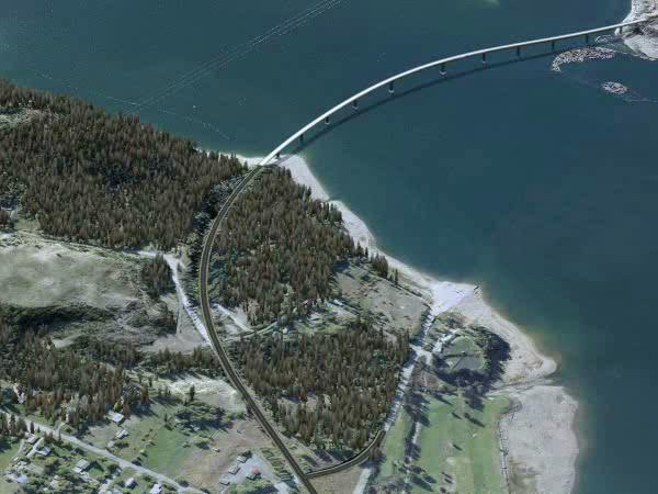
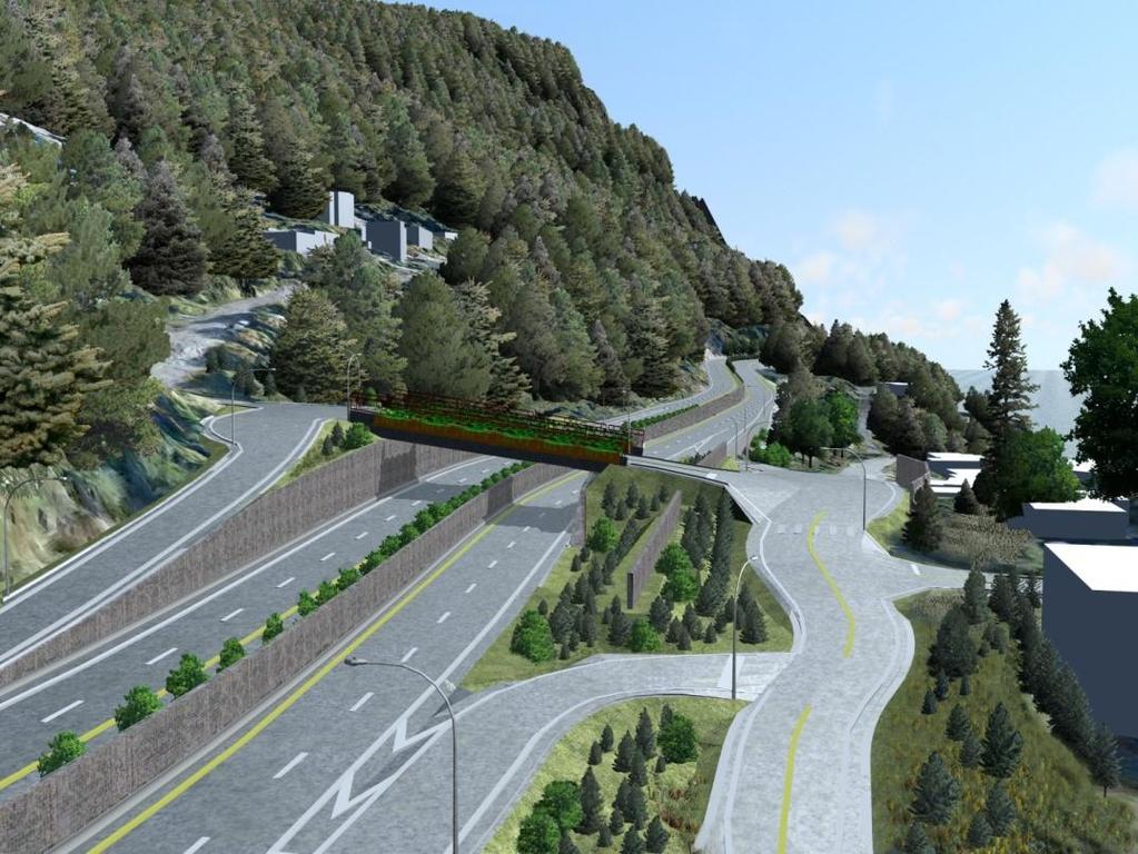
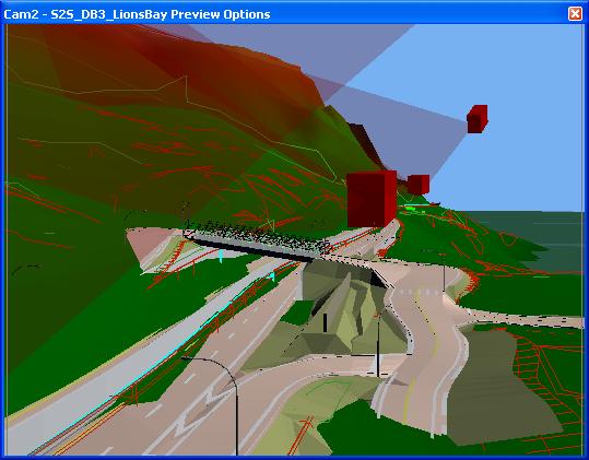
34 Examples - Transportation 34

35 Examples Mineral Exploration 35
36 Prices of Tools KLT (US$25,000 plus specialized hardware to buy separately) Visual Nature Studio (US$2500) Autodesk 3D Studio Max (US$3495) Google SketchUp Pro (US$500) ArcGIS 3D Analyst (US$2500) Engage 3D (US$4000) PhotoShop (US$700) Adobe Premier Elements (US$800) 36
37 More Information For more 3D views and flythroughs, go to 37
38 Thank You Any questions? 38
TechTime. New Mapping Tools for Transportation Engineering. Brendan Walashek McElhanney Consulting Services Ltd.
 New Mapping Tls fr Transprtatin Engineering Brendan Walashek McElhanney Cnsulting Services Ltd. New Mapping Tls fr Transprtatin Engineering Agenda A Quick Histry f 3D Views Surce Data fr 3D Views Tls t
3D CITY MODELLING WITH CYBERCITY-MODELER
 1 3D CITY MODELLING WITH CYBERCITY-MODELER Kilian Ulm 1 and Daniela Poli 1 1. CyberCity AG, Zurich, Switzerland, (kilian.ulm, daniela.poli)@cybercity.tv ABSTRACT 3D city models using stereo aerial-/satellite
Chris Rotondo, GIS Specialist. Prince George s County Planning Department The Maryland-National Capital Park and Planning Commission
 Chris Rotondo, GIS Specialist Prince George s County Planning Department The Maryland-National Capital Park and Planning Commission MSGIC, July 2015 A 150-page report on implementing 3D technology, prepared
Feature Extraction from Imagery & Lidar. Kurt Schwoppe, Esri Mark Romero, Esri Gregory Bacon, Fairfax County
 Feature Extraction from & Lidar Kurt Schwoppe, Esri Mark Romero, Esri Gregory Bacon, Fairfax County Today s Speakers Image Processing Experts and Good Colleagues Kurt Schwoppe Industry Lead Esri Mark Romero
Digital Elevation Models (DEM)
") Digital Elevation Models (DEM) Digital representation of the terrain surface also referred to as Digital Terrain Models (DTM) Digital Elevation Models (DEM) How has relief depiction changed with digital
Digital Elevation Models (DEM) Digital representation of the terrain surface also referred to as Digital Terrain Models (DTM) Digital Elevation Models (DEM) How has relief depiction changed with digital
Feature Enhancements by Release
 Autodesk Map Feature Enhancements by Release This document highlights the feature enhancements that have occurred with each release of Autodesk Map software from Release 4 (2000i) through the current 2004
Virtualizing Boathouses in Dwejra, Malta for Access through WebGIS Applications (Abstract)
") Virtualizing Boathouses in Dwejra, Malta for Access through WebGIS Applications (Abstract) Daniel LANGENHAUN, Erich BUHMANN, Matthias PIETSCH, Santosh CHOUGULE and Philip PAAR 1 Keywords Digital Landscape
Virtualizing Boathouses in Dwejra, Malta for Access through WebGIS Applications (Abstract) Daniel LANGENHAUN, Erich BUHMANN, Matthias PIETSCH, Santosh CHOUGULE and Philip PAAR 1 Keywords Digital Landscape
TCP MDT Digital Terrain Model - V7.5
 TCP MDT Digital Terrain Model - V7.5 Standard Version Introduction The Standard Version is suitable for carrying out all kinds of topographical survey projects, terrain profiles, volume calculations etc.
The GIS Spatial Data Model
 The GIS Spatial Data Model Introduction: Spatial data are what drive a GIS. Every piece of functionality that makes a GIS separate from another analytical environment is rooted in the spatially explicit
Introduction to InfraWorks 360 for Civil
 Eric Chappell Autodesk Aimed at Civil industry professional, this class will cover basic importing of data sources to make an existing model, followed by creation of roads, buildings, and city furniture
Alaska Department of Transportation Roads to Resources Project LiDAR & Imagery Quality Assurance Report Juneau Access South Corridor
 Alaska Department of Transportation Roads to Resources Project LiDAR & Imagery Quality Assurance Report Juneau Access South Corridor Written by Rick Guritz Alaska Satellite Facility Nov. 24, 2015 Contents
3D Analyst Visualization with ArcGlobe. Brady Hoak, ESRI DC
 3D Analyst Visualization with ArcGlobe Brady Hoak, ESRI DC 3D GIS Viewing geospatial data in 3D leads to new insights 2D 3D Sometimes you need to edit your data in 3D 2D 3D Some problems can only be solved
3D GIS MODELING APPLICATION FOR DEVELOPING THE BUTUAN CITY 3D MODEL
 3D GIS MODELING APPLICATION FOR DEVELOPING THE BUTUAN CITY 3D MODEL Alexander T. Demetillo, Michelle V. Japitana and Peter John A. Galamiton CLAIMS-GIS Project, College of Engineering and Information Technology,
3D Data Modelling at Esri. Paul Hardy Business Development Consultant Esri Europe
 3D Data Modelling at Esri Paul Hardy phardy@esri.com Business Development Consultant Esri Europe Users of 3D GIS Local government Facilities management Civil engineering 3D GIS Defense / Public Safety
Surpac Google Earth Tools
 Surpac Google Earth Tools Google Earth is a free software program that lets you fly anywhere on Earth to view satellite imagery, maps, terrain and 3D buildings. When used in conjunction with SURPAC, it
2011 Bentley Systems, Incorporated. Bentley Descartes V8i Advancing Information Modeling For Intelligent Infrastructure
 Bentley Descartes V8i Advancing Information Modeling For Intelligent Infrastructure Agenda Why would you need Bentley Descartes? What is Bentley Descartes? Advanced Point Cloud Workflows Advanced Terrain
Critical Essentials. Overview. Objectives. Recommended Prior Skills. Upon completion of these topics, you should be able to:
 Critical Essentials Visualizing spaces in three dimensions is critical to the success of the design of architectural spaces. The interplay of light, color, and space are critical concepts to master. Traditional
Creating, balancing and mosaicing Orthophotos
 Creating, balancing and mosaicing Orthophotos Wizards Map production 3D presentations Annotation Orthophoto Surface gridding Contouring Image mosaicing Data compression Geocoding Spatial analysis Raster
3D Terrain Modelling of the Amyntaio Ptolemais Basin
 2nd International Workshop in Geoenvironment and 1 3D Terrain Modelling of the Amyntaio Ptolemais Basin G. Argyris, I. Kapageridis and A. Triantafyllou Department of Geotechnology and Environmental Engineering,
Lidar Working with LAS Datasets
 2013 Esri International User Conference July 8 12, 2013 San Diego, California Technical Workshop Lidar Working with LAS Datasets Raghav Vemula (3D Team) Esri UC2013. Technical Workshop. Agenda Las Dataset
Lidar and GIS: Applications and Examples. Dan Hedges Clayton Crawford
 Lidar and GIS: Applications and Examples Dan Hedges Clayton Crawford Outline Data structures, tools, and workflows Assessing lidar point coverage and sample density Creating raster DEMs and DSMs Data area
PhotoScan. Fully automated professional photogrammetric kit
 PhotoScan Fully automated professional photogrammetric kit Agisoft PhotoScan is a stand-alone photogrammetric software solution for automatic generation of dense point clouds, textured polygonal models,
Data Interoperability Advanced Use
 Data Interoperability Advanced Use Bruce Harold Dale Lutz bharold@esri.com Safe Software This is your world ask us today about best practices Automate Moving Data No Domain Limitations ArcGIS Data Interoperability
GIS-Generated Street Tree Inventory Pilot Study
 GIS-Generated Street Tree Inventory Pilot Study Prepared for: MSGIC Meeting Prepared by: Beth Schrayshuen, PE Marla Johnson, GISP 21 July 2017 Agenda 2 Purpose of Street Tree Inventory Pilot Study Evaluation
Creating raster DEMs and DSMs from large lidar point collections. Summary. Coming up with a plan. Using the Point To Raster geoprocessing tool
 Page 1 of 5 Creating raster DEMs and DSMs from large lidar point collections ArcGIS 10 Summary Raster, or gridded, elevation models are one of the most common GIS data types. They can be used in many ways
Integrating CAD Data with ArcGIS
 Integrating CAD Data with ArcGIS Agenda An Overview of CAD Drawings CAD Data Structure in ArcGIS Visualization Georeferencing Data Conversion ArcGIS for AutoCAD Q & A CAD Drawings - Overview Widely used
What's New in Voxler 4?
 What's New in Voxler 4? We have compiled a list of some of the top new features in Voxler 4. This list is only a small sampling of the new features added to Voxler 4. Drape GIS Data and Vector Maps over
COPYRIGHTED MATERIAL. Introduction to 3D Data: Modeling with ArcGIS 3D Analyst and Google Earth CHAPTER 1
 CHAPTER 1 Introduction to 3D Data: Modeling with ArcGIS 3D Analyst and Google Earth Introduction to 3D Data is a self - study tutorial workbook that teaches you how to create data and maps with ESRI s
Objectives Learn how to work with projections in SMS, and how to combine data from different coordinate systems into the same SMS project.
 v. 12.2 SMS 12.2 Tutorial Working with map projections in SMS Objectives Learn how to work with projections in SMS, and how to combine data from different coordinate systems into the same SMS project.
A New Direction in GIS Data Collection or Why Are You Still in the Field?
 GeoAutomation The Mobile Mapping System Survey-Enabled Imagery A New Direction in GIS Data Collection or Why Are You Still in the Field? Presentation to: URISA BC GIS Technology Showcase January 19, 2011
Luana Valentini InternetGIS course
 Google SketchUp - A brief introduction - Luana Valentini InternetGIS course - 2011 Create 3D models and share them with the world Google SketchUp is software that allows you to create 3D models of anything
National Science Foundation Engineering Research Center. Bingcai Zhang BAE Systems San Diego, CA
 Bingcai Zhang BAE Systems San Diego, CA 92127 Bingcai.zhang@BAESystems.com Introduction It is a trivial task for a five-year-old child to recognize and name an object such as a car, house or building.
Mobile Mapping and Navigation. Brad Kohlmeyer NAVTEQ Research
 Mobile Mapping and Navigation Brad Kohlmeyer NAVTEQ Research Mobile Mapping & Navigation Markets Automotive Enterprise Internet & Wireless Mobile Devices 2 Local Knowledge & Presence Used to Create Most
Outline of Presentation. Introduction to Overwatch Geospatial Software Feature Analyst and LIDAR Analyst Software
 Outline of Presentation Automated Feature Extraction from Terrestrial and Airborne LIDAR Presented By: Stuart Blundell Overwatch Geospatial - VLS Ops Co-Author: David W. Opitz Overwatch Geospatial - VLS
Lecture 06. Raster and Vector Data Models. Part (1) Common Data Models. Raster. Vector. Points. Points. ( x,y ) Area. Area Line.
 Common Data Models. Raster. Vector. Points. Points. ( x,y ) Area. Area Line.") Lecture 06 Raster and Vector Data Models Part (1) 1 Common Data Models Vector Raster Y Points Points ( x,y ) Line Area Line Area 2 X 1 3 Raster uses a grid cell structure Vector is more like a drawn map
Lecture 06 Raster and Vector Data Models Part (1) 1 Common Data Models Vector Raster Y Points Points ( x,y ) Line Area Line Area 2 X 1 3 Raster uses a grid cell structure Vector is more like a drawn map
An Introduction to Lidar & Forestry May 2013
 An Introduction to Lidar & Forestry May 2013 Introduction to Lidar & Forestry Lidar technology Derivatives from point clouds Applied to forestry Publish & Share Futures Lidar Light Detection And Ranging
GEOGRAPHIC INFORMATION SYSTEMS Lecture 25: 3D Analyst
 GEOGRAPHIC INFORMATION SYSTEMS Lecture 25: 3D Analyst 3D Analyst - 3D Analyst is an ArcGIS extension designed to work with TIN data (triangulated irregular network) - many of the tools in 3D Analyst also
SkylineGlobe - Products Overview
 SkylineGlobe - Products Overview Skyline Software Systems, Inc. is a leading provider of 3D earth visualization software and services. The company offers a comprehensive platform of applications, tools
Tools, Tips, and Workflows Exporting Final Product LP360
 LP360 Support Revision 1.0 l Final products can be exported from LIDAR data using either LP360 command line executables or the LP360 Export Wizard. Some export functions and resulting products include,
Surveying like never before
 CAD functionalities GCP Mapping and Aerial Image Processing Software for Land Surveying Specialists Surveying like never before www.3dsurvey.si Modri Planet d.o.o., Distributors: info@3dsurvey.si +386
Questions and Answers
 Autodesk AutoCAD Raster Design 2011 Questions and Answers AutoCAD Raster Design 2011 Questions and Answers Make the most of rasterized scanned drawings, maps, aerial photos, satellite imagery, and digital
Network licenses (5 seat minimum - price per seat and excl. VAT): Network extension (existing license required - price per seat and excl.
: Network extension (existing license required - price per seat and excl.") Pricing SketchUp Pro If you want to buy SketchUp Pro there are several options to choose from: Commercial Licenses A Standalone license costs per license only (excl. VAT): 655,- This price includes 1 year
Pricing SketchUp Pro If you want to buy SketchUp Pro there are several options to choose from: Commercial Licenses A Standalone license costs per license only (excl. VAT): 655,- This price includes 1 year
3d exporter EA56C5116E31E464DEAF EB92. 3d Exporter 1 / 6
 3d Exporter 1 / 6 2 / 6 3 / 6 3d Exporter We would like to show you a description here but the site won t allow us. 3dexport.com Exporters are native software features or external plug-ins that implement
Visualization with ArcGlobe. Brady Hoak
 Visualization with ArcGlobe Brady Hoak Contents What is ArcGlobe? 3D Mapping and ArcGlobe Displaying data in ArcGlobe ArcGlobe tools Tips for constructing ArcGlobe documents New at ArcGIS 9.3 ArcGIS integration
Features available in this release of Encom Discover are: Simplified installation - Discover and Discover 3D are now bundled in the same installer
 EncomTM DiscoverTM v12.0 Pitney Bowes Business Insight s latest release of Encom Discover showcases the ongoing innovative developments that have made Discover the must-have GIS application for geoscientists
Remote Sensing in an
 Chapter 2: Adding Data to a Map Document Remote Sensing in an ArcMap Environment Remote Sensing Analysis in an ArcMap Environment Tammy E. Parece Image source: landsat.usgs.gov Tammy Parece James Campbell
Visual Information Solutions. E3De. The interactive software environment for extracting 3D information from LiDAR data.
 Visual Information Solutions E3De. The interactive software environment for extracting 3D information from LiDAR data. Photorealistic Visualizations. 3D Feature Extraction. Versatile Geospatial Products.
3D Model - Data Transfer Guide
 Introduction 3D Model - The Leicester City model is a photogrammetric survey based 3D representation of 380ha of Leicester s Central Regeneration Area. The model is to be: Used for marketing and inward
Municipal Projects in Cambridge Using a LiDAR Dataset. NEURISA Day 2012 Sturbridge, MA
 Municipal Projects in Cambridge Using a LiDAR Dataset NEURISA Day 2012 Sturbridge, MA October 15, 2012 Jeff Amero, GIS Manager, City of Cambridge Presentation Overview Background on the LiDAR dataset Solar
Lecture 21 - Chapter 8 (Raster Analysis, part2)
") GEOL 452/552 - GIS for Geoscientists I Lecture 21 - Chapter 8 (Raster Analysis, part2) Today: Digital Elevation Models (DEMs), Topographic functions (surface analysis): slope, aspect hillshade, viewshed,
GEOL 452/552 - GIS for Geoscientists I Lecture 21 - Chapter 8 (Raster Analysis, part2) Today: Digital Elevation Models (DEMs), Topographic functions (surface analysis): slope, aspect hillshade, viewshed,
WebEasy GIS is a cloud computing application for the web consultation of maps and geographic data.
 WebEasy GIS Geographic Information System WebEasy GIS is a cloud computing application for the web consultation of maps and geographic data. WebEasy GIS has a practical and intuitive interface, it works
Files Used in this Tutorial
 Generate Point Clouds and DSM Tutorial This tutorial shows how to generate point clouds and a digital surface model (DSM) from IKONOS satellite stereo imagery. You will view the resulting point clouds
,
 Weekdays:- 1½ hrs / 3 days Fastrack:- 1½hrs / Day [Class Room and Online] ISO 9001:2015 CERTIFIED ADMEC Multimedia Institute www.admecindia.co.in 9911782350, 9811818122 Want to learn multi-purpose, easy
Objectives Learn how to work with projections in SMS, and how to combine data from different coordinate systems into the same SMS project.
 v. 12.3 SMS 12.3 Tutorial Working with map projections in SMS Objectives Learn how to work with projections in SMS, and how to combine data from different coordinate systems into the same SMS project.
RELEASE NOTES FOR PHOTOMESH 7.5.1
 RELEASE NOTES FOR PHOTOMESH 7.5.1 About PhotoMesh Skyline s PhotoMesh fully automates the generation of high-resolution, textured, 3D mesh models from standard 2D photographs, offering a significant reduction
Slide 1. Bentley Descartes V8i. Presented by: Inga Morozoff, Bentley
 Slide 1 Bentley Descartes V8i Presented by: Inga Morozoff, Bentley Slide 2 Agenda What is Bentley Descartes? Where is it used? Features Benefits Live demo Questions and Answers 2 WWW.BENTLEY.COM Slide
E3De. E3De Discover the Next Dimension of Your Data.
 International Support Exelis Visual Information Solutions is a global company with direct offices in North America, Europe, and Asia. Combined with our extensive, worldwide distributor network, we can
PhotoScan. Fully automated professional photogrammetric kit
 PhotoScan Fully automated professional photogrammetric kit Agisoft PhotoScan is a stand-alone photogrammetric software solution for automatic generation of dense point clouds, textured polygonal models,
Using VBA and ArcMap to Create and Export 3D Buildings
 Using VBA and ArcMap to Create and Export 3D Buildings Abstract Brian Bradshaw Layers in ArcScene containing polygon features can be extruded to create 3D blocks for display in the current scene. While
Steps for Modeling a Proposed New Reservoir in GIS
 Steps for Modeling a Proposed New Reservoir in GIS Requirements: ArcGIS ArcMap, ArcScene, Spatial Analyst, and 3D Analyst There s a new reservoir proposed for Right Hand Fork in Logan Canyon. I wanted
GE1LC7 - Getting to Know Bentley Descartes for Advanced Image Viewing, Editing and Processing
 GE1LC7 - Getting to Know Bentley Descartes for Advanced Image Viewing, Editing and Processing Inga Morozoff Introduction: Raster data is everywhere - whether you do CAD design, mapping or GIS analysis,
Creating a 3D GIS Program in the City of Cambridge
 Creating a 3D GIS Program in the City of Cambridge JEFF AMERO CITY OF CAMBRIDGE ESRI User Conference, San Diego, CA July 13, 2017 Presentation Overview -Bringing 3D GIS to Cambridge -Components of the
Image Services for Elevation Data
 Image Services for Elevation Data Peter Becker Need for Elevation Using Image Services for Elevation Data sources Creating Elevation Service Requirement: GIS and Imagery, Integrated and Accessible Field
Digital Raster Acquisition Project Eastern Ontario (DRAPE) 2014 Digital Surface Model and Digital Terrain Model
 2014 Digital Surface Model and Digital Terrain Model") Digital Raster Acquisition Project Eastern Ontario (DRAPE) 2014 Digital Surface Model and Digital Terrain Model User Guide Provincial Mapping Unit Mapping and Information Resources Branch Corporate Management
Digital Raster Acquisition Project Eastern Ontario (DRAPE) 2014 Digital Surface Model and Digital Terrain Model User Guide Provincial Mapping Unit Mapping and Information Resources Branch Corporate Management
TcpMDT Version 7.0 Summary of Differences with Version 6.5
 Sumatra, 9 E-29190 Málaga (Spain) www.aplitop.com Tel.: +34 95 2439771 Fax: +34 95 2431371 TcpMDT Version 7.0 Summary of Differences with Version 6.5 CAD Versions supported TcpMDT 7 works with several
From 2D to 3D at Esri
 From 2D to 3D at Esri OGC/EuroSDR workshop on CityGML in National Mapping Paul Hardy phardy@esri.com Business Development Consultant National Mapping & Cadastre Esri 3D GIS Visualize Manage Share Analyze
Server Usage & Third-Party Viewers
 Server Usage & Third-Party Viewers October 2016 HiPER LOOK Version 1.4.16.0 Copyright 2015 PIXIA Corp. All Rights Reserved. Table of Contents HiPER LOOK Server Introduction... 2 Google Earth... 2 Installation...2
The Reference Library Generating Low Confidence Polygons
 GeoCue Support Team In the new ASPRS Positional Accuracy Standards for Digital Geospatial Data, low confidence areas within LIDAR data are defined to be where the bare earth model might not meet the overall
Release Notes SPECTRA PRECISION SURVEY OFFICE. Versions 3.30 (64-bit)
") Release Notes SPECTRA PRECISION SURVEY OFFICE Versions 3.30 (64-bit) Corporate office: Spectra Precision 10368 Westmoor Drive Westminster, CO 80021 USA www.spectraprecision.com Copyright and trademarks:
Release Notes SPECTRA PRECISION SURVEY OFFICE Versions 3.30 (64-bit) Corporate office: Spectra Precision 10368 Westmoor Drive Westminster, CO 80021 USA www.spectraprecision.com Copyright and trademarks:
Connecticut Association of Assessing Officers CT Statewide GIS Data Acquisition & Services. June 22, :00 am
 Connecticut Association of Assessing Officers 2016 CT Statewide GIS Data Acquisition & Services June 22, 2016 9:00 am Presented by: Shawn Benham, PMP Project Manager ---------------------------- Brad Arshat,
Intelligent photogrammetry. Agisoft
 Intelligent photogrammetry Agisoft Agisoft Metashape is a cutting edge software solution, with its engine core driving photogrammetry to its ultimate limits, while the whole system is designed to deliver
2/9/2016. Session Agenda: Implementing new Geospatial Technologies for more efficient data capture
 Implementing new Geospatial Technologies for more efficient data capture Jay Haskamp Applied Geospatial Engineer Steve Richter VP Sales Session Agenda: Today s changing technologies and what lies ahead
A Basic Guide to Modeling Landscapes in Google SketchUp
 DYNASCAPE SOFTWARE INC. A Basic Guide to Modeling Landscapes in Google SketchUp A DS Sketch 3D User Guide Volume 2 This guide will take you through the steps of creating a 3D model of a landscape in Google
Ilham Marsudi Universitas Negeri Yogyakarta Yogyakarta, Indonesia
 1st International Conference on Technology and Vocational Teachers (ICTVT 2017) Making a Digital Contour Map Ilham Marsudi Universitas Negeri Yogyakarta Yogyakarta, Indonesia ilham@uny.ac.id Abstract---
LiDAR & Orthophoto Data Report
 LiDAR & Orthophoto Data Report Tofino Flood Plain Mapping Data collected and prepared for: District of Tofino, BC 121 3 rd Street Tofino, BC V0R 2Z0 Eagle Mapping Ltd. #201 2071 Kingsway Ave Port Coquitlam,
Artlantis training for new users
 Artlantis training for new users page 2 This training program reviews the main features of Artlantis. You will learn about the various presentation types such as still images, ivisit 3D panoramas, VR objects
Addressing Geospatial Big Data Management and Distribution Challenges ERDAS APOLLO & ECW
 Addressing Geospatial Big Data Management and Distribution Challenges ERDAS APOLLO & ECW Nouman Ahmed GeoSystems-Me (Hexagon Geospatial / ERDAS Regional Partner) Enterprise Solutions Architect Hexagon
Drone2Map for ArcGIS: Bring Drone Imagery into ArcGIS. Will
 Drone2Map for ArcGIS: Bring Drone Imagery into ArcGIS Will Meyers @MeyersMaps A New Window on the World Personal Mapping for Micro-Geographies Accurate High Quality Simple Low-Cost Drone2Map for ArcGIS
GIS Interoperability with BIG data in InfraWorks David Lawrence URS
 GIS Interoperability with BIG data in InfraWorks David Lawrence URS CV6703-P This class will discuss the lessons learned in dealing with a large project area that covered over 27,500 square miles of land
Modelling. Ruth Aylett
 Modelling Ruth Aylett Overview Basic issues Modelling packages Low polygon modelling Importing models Buildings Photogrammetry Laser range finders LIDAR The great outdoors Cheap methods 3D Authoring tools
Contents of Lecture. Surface (Terrain) Data Models. Terrain Surface Representation. Sampling in Surface Model DEM
 Data Models. Terrain Surface Representation. Sampling in Surface Model DEM") Lecture 13: Advanced Data Models: Terrain mapping and Analysis Contents of Lecture Surface Data Models DEM GRID Model TIN Model Visibility Analysis Geography 373 Spring, 2006 Changjoo Kim 11/29/2006 1
Lecture 13: Advanced Data Models: Terrain mapping and Analysis Contents of Lecture Surface Data Models DEM GRID Model TIN Model Visibility Analysis Geography 373 Spring, 2006 Changjoo Kim 11/29/2006 1
Objectives Learn how to work with projections in GMS, and how to combine data from different coordinate systems into the same GMS project.
 v. 10.2 GMS 10.2 Tutorial Working with map projections in GMS Objectives Learn how to work with projections in GMS, and how to combine data from different coordinate systems into the same GMS project.
Creating, managing and utilizing a 3D Virtual City in ArcGIS Tamrat Belayneh Eric Wittner
 Creating, managing and utilizing a 3D Virtual City in ArcGIS 10.1 Tamrat Belayneh (tbelayneh@esri.com) Eric Wittner (ewittner@esri.com ) Contents 3D Mapping & Ingredients of a 3D Virtual City Creating
Esri UC2013. Technical Workshop. Type Presentation Name Here
 Type Presentation Name Here 2013 Esri International User Conference July 8 12, 2013 San Diego, California Technical Workshop 3D Analyst An Introduction Deepinder Deol Michael Contreras Why use 3D GIS?
Exelis Visual Information Solutions Capability Overview Presented to NetHope October 8, Brian Farr Academic & NGO Program Manager
 Exelis Visual Information Solutions Capability Overview Presented to NetHope October 8, 2013 Brian Farr Academic & NGO Program Manager Agenda Overview of ENVI Platform ENVI+IDL ENVI EX ENVI LiDAR Integration
2011 Bentley Systems, Incorporated. Bentley Descartes V8i (SELECTseries 3) Advancing Information Modeling For Intelligent Infrastructure
 Advancing Information Modeling For Intelligent Infrastructure") Bentley Descartes V8i (SELECTseries 3) Advancing Information Modeling For Intelligent Infrastructure What is Bentley Descartes? Image Processing Raster Geo-Referencing Advanced raster transformation (warping,
Bentley Descartes V8i (SELECTseries 3) Advancing Information Modeling For Intelligent Infrastructure What is Bentley Descartes? Image Processing Raster Geo-Referencing Advanced raster transformation (warping,
LORI COLLINS, RESEARCH ASSOCIATE PROFESSOR CONTRIBUTIONS BY: RICHARD MCKENZIE AND GARRETT SPEED, DHHC USF L IBRARIES
 LORI COLLINS, RESEARCH ASSOCIATE PROFESSOR CONTRIBUTIONS BY: RICHARD MCKENZIE AND GARRETT SPEED, DHHC USF L IBRARIES AERIAL AND TERRESTRIAL SURVEY WORKFLOWS Workflow from project planning applications
v SMS Tutorials Working with Rasters Prerequisites Requirements Time Objectives
 v. 12.2 SMS 12.2 Tutorial Objectives Learn how to import a Raster, view elevations at individual points, change display options for multiple views of the data, show the 2D profile plots, and interpolate
GNSS/GIS DATA COLLECTION SOFTWARE
 GNSS/GIS DATA COLLECTION SOFTWARE Product Overview // August 2014 EZTAG CE SOFTWARE Designed for highly productive field GIS data collection EZTag CE TM software is designed to collect simple or complex
Reality Check: Processing LiDAR Data. A story of data, more data and some more data
 Reality Check: Processing LiDAR Data A story of data, more data and some more data Red River of the North Red River of the North Red River of the North Red River of the North Introduction and Background
Photo based Terrain Data Acquisition & 3D Modeling
 Photo based Terrain Data Acquisition & 3D Modeling June 7, 2013 Howard Hahn Kansas State University Partial funding by: KSU Office of Research and Sponsored Programs Introduction: Need Application 1 Monitoring
Notice Inviting Quotations
 From Chairperson, Department of Geography, Centre of Advanced Study Panjab University, Chandigarh. To Notice Inviting Quotations No Geog/986 Dated : 12.09.14 Dear Sir, Please quote Technical and Financial
Esri International User Conference. July San Diego Convention Center. Lidar Solutions. Clayton Crawford
 Esri International User Conference July 23 27 San Diego Convention Center Lidar Solutions Clayton Crawford Outline Data structures, tools, and workflows Assessing lidar point coverage and sample density
Introduction to LiDAR
 Introduction to LiDAR Our goals here are to introduce you to LiDAR data, to show you how to download it for an area of interest, and to better understand the data and uses through some simple manipulations.
I CALCULATIONS WITHIN AN ATTRIBUTE TABLE
 Geology & Geophysics REU GPS/GIS 1-day workshop handout #4: Working with data in ArcGIS You will create a raster DEM by interpolating contour data, create a shaded relief image, and pull data out of the
PlaceMap. Accommodation. Slide 1
 PlaceMap for Accommodation Slide 1 PlaceMap Using the power of Google Earth to store and display all of your spatial data in a much more dynamic way Google Earth is a free software program that lets you
COMPARATIVE CHARACTERISTICS OF DEM OBTAINED FROM SATELLITE IMAGES SPOT-5 AND TK-350
 COMPARATIVE CHARACTERISTICS OF DEM OBTAINED FROM SATELLITE IMAGES SPOT-5 AND TK-350 Dr. V. F. Chekalin a*, M. M. Fomtchenko a* a Sovinformsputnik, 47, Leningradsky Pr., 125167 Moscow, Russia common@sovinformsputnik.com
Map Library ArcView Version 1 02/20/03 Page 1 of 12. ArcView GIS
 Map Library ArcView Version 1 02/20/03 Page 1 of 12 1. Introduction 1 ArcView GIS ArcView is the most popular desktop GIS analysis and map presentation software package.. With ArcView GIS you can create
Introduction to LiDAR
 Introduction to LiDAR Our goals here are to introduce you to LiDAR data. LiDAR data is becoming common, provides ground, building, and vegetation heights at high accuracy and detail, and is available statewide.
MODULE 1 BASIC LIDAR TECHNIQUES
 MODULE SCENARIO One of the first tasks a geographic information systems (GIS) department using lidar data should perform is to check the quality of the data delivered by the data provider. The department