Experiences with. data for use in apps
|
|
|
- Wesley Golden
- 5 years ago
- Views:
Transcription


1 Experiences with publishing INSPIRE data for use in apps Presentation to: Author: Date: INSPIRE Conference 2014 Clemens Portele
2 From INSPIRE Conference 2013: "How to use INSPIRE data?" INSPIRE is looking only at part of the dataflow Applications Internet Lack of guidance and tool support View Service Spatial Data Set Download Service INSPIRE Directive Implementing Rules Technical Guidance interactive instruments GmbH

3 From INSPIRE Conference 2013: "How to use INSPIRE data?" Patterns for using INSPIRE data today Applications Application Server ETL Improved View Service Internet Direct Access Download Service Download Service providing incremental updates Spatial Data Set Spatial Data Set interactive instruments GmbH
4 National Mapping & Cadastral Authorities NSDIs Other Data Providers ELF Platform: Reference Data & Services Reference data Reference data Reference data Reference data INSPIRE Network Services Applications: Use Reference Data and Other Data in any Application Environment Map Applications Value added Web Services ArcGIS Online: A Data and Application Hub in the ELF Infrastructure feature data, gridded data, map tiles elf.maps.arcgis.com Web Services JavaScript APIs Mobile SDKs Map Applications
5 Patterns for using INSPIRE data on the web Use a base map with authoritative reference data likely needs multiple layouts for different applications Prepare business data for use in a map based app: geo reference data only needs thematic/feature identifiers and geometry from INSPIRE data Use feature data directly in apps needs easy integration, good API, good documentation, etc.
6 Developer expectations Support the tools and platforms of my choice JavaScript/HTML5, ios, Android, Windows, OS X, Java, ArcGIS, Google Maps Engine, Leaflet, Good documentation and sample code An active developer community Get results in minutes Just pointing to INSPIRE / OGC documentation is not sufficient

7 Creating a simple JavaScript app
8 Prepare data for use in map based apps Flatten structures: most platforms for map based apps only support tabular structures with a geometry field Reduce content: the data becomes easier to understand and handle by developers that are not INSPIRE experts or familiar with spatial data
9 Example: geographical names Reduce unlimited number of rich geographical names per feature

10 Example: geographical names 2 or 3 simple name attributes, optional language information for each name in JSON:... "name.1" : "Brussel", "name.lang.1" : "nl", "name.2" : "Bruxelles", "name.lang.1" : "fr",...

11 Prepare data for use in map based apps Make layers explicit: subtype the feature types in cases where a map based app shows different features from the same feature type depending on the scale

12 Prepare data for use in map based apps Example: a layer / feature class per administrative or statistical unit level
13 API support for using data in map based apps The Feature Service in the ArcGIS REST API provides the capabilities of an INSPIRE direct access download service Plus several capabilities that are important for using such services directly in map based apps and which go beyond a "download service", e.g.: Support for HTTP caching the ArcGIS JavaScript API requests feature data in vector tiles consistent with the map tile hierarchy improves user experience when panning and zooming Generalisation of geometries geometries are simplified to fit the scale of the current map scale lower memory footprint in the client and faster data transmission (example for accessing level 1 administrative units in a constant area for different scales: 1:37M 247kB; 1:1.1M 1.3MB; 1:289k 4.1MB; no generalisation 10.4MB) Scale and rendering hints feature layers provide a hint for which scale levels they are suitable and how the features should be portrayed on a map

14 ELF in ArcGIS Online

15 Sample layers from EuroGlobalMap (open data)

16 Administrative and statistical units & Base map
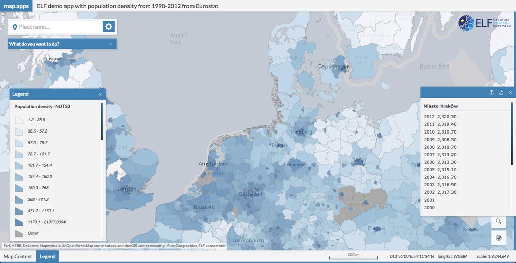
17 Population density
 2 Access ELF feature service")

18 Geo referencing population density data 1 2 in ArcGIS Online FME Cloud 3 in ArcGIS Online 1 Access statistical data from Eurostat website (SDMX or CSV) 2 Access ELF feature service "administrative and statistical units" (NUTS area geometries) 3 Create/update feature service with statistical data and polygon geometries The cloud based workflow supports unattended/periodic execution

19 XtraProxy Alternative option for accessing INSPIRE Web Feature Services from ArcGIS clients, if caching data in ArcGIS Online is not an option or too much overhead Transparently publishes OGC Web Feature Services as GeoServices REST API feature services

20 XtraProxy Automatic flattening of complex structures Configurable to remove unneeded attributes Structure maintained in HTML popups Example: INSPIRE/ELF WFS for Administrative Units from the Czech Republic Sample services:
ELF- joining Europe together
 ELF- joining Europe together An open standard based multinational web mapping project, building on INSPIRE Presentation to: ISO/TC211 Standards in Action Workshop By: Date: Jari Reini 10 th June 2015 19
How to Report on Data Quality in a Multinational Environment?
 How to Report on Data Quality in a Multinational Environment? Presentation to: By: Date: SDMQ2015 Anja Hopfstock, BKG 20.01.2015 Agenda ELF architecture Data Quality Management Data Quality Reporting Summary
Validating services and data in an SDI
 Validating services and data in an SDI Presentation to: By: Date: INSPIRE Conference Clemens Portele, Jon Herrmann, Roy Mellum 30 September 2016 4 October, 2016 ELF is the response from the European Mapping
Leveraging OGC Services in ArcGIS Server. Satish Sankaran, Esri Yingqi Tang, Esri
 Leveraging OGC Services in ArcGIS Server Satish Sankaran, Esri Yingqi Tang, Esri GIS Creating and Managing Geo Information Products - Proprietary - Open Specifications - Standards Dissemination of Geo
Using ArcGIS for Server. Javier Abadía, Esri España Peter McDaid, Esri UK
 Using ArcGIS for Server Javier Abadía, Esri España Peter McDaid, Esri UK 1. Intro 2. ArcGIS for Server = Geospatial Apps Server 3. Map Services Publishing Flow Apps 4. Spatial Functionality Services Publishing
Spatial Data on the Web
 Spatial Data on the Web Tools and guidance for data providers Clemens Portele, Andreas Zahnen, Michael Lutz, Alexander Kotsev The European Commission s science and knowledge service Joint Research Centre
Spatial Data on the Web
 Spatial Data on the Web Tools and guidance for data providers The European Commission s science and knowledge service W3C Data on the Web Best Practices 35 W3C/OGC Spatial Data on the Web Best Practices
May 22, 2013 Ronald Reagan Building and International Trade Center Washington, DC USA
 May 22, 2013 Ronald Reagan Building and International Trade Center Washington, DC USA 1 Introduction to MapViewer & Tools for Your Business Apps and Mobile Devices Albert Godfrind Oracle Spatial Architect
European Location Framework (ELF) acting as a facilitator implementing INSPIRE
 acting as a facilitator implementing INSPIRE") www.eurogeographics.org European Location Framework (ELF) acting as a facilitator implementing INSPIRE Saulius Urbanas, Mick Cory (EuroGeographics) 29 October 2016 Copyright 2013 EuroGeographics EuroGeographics
www.eurogeographics.org European Location Framework (ELF) acting as a facilitator implementing INSPIRE Saulius Urbanas, Mick Cory (EuroGeographics) 29 October 2016 Copyright 2013 EuroGeographics EuroGeographics
Getting Started with ArcGIS for Server. Charmel Menzel and Ken Gorton
 Getting Started with ArcGIS for Server Charmel Menzel and Ken Gorton Agenda What is ArcGIS for Server? Types of Web services Publishing resources onto the Web Clients to ArcGIS for Server Editions and
Enabling High-Quality Printing in Web Applications. Tanu Hoque & Craig Williams
 Enabling High-Quality Printing in Web Applications Tanu Hoque & Craig Williams New Modern Print Service with ArcGIS Enterprise 10.6 Quality Improvements: Support for true color level transparency PDF produced
An Introduction to GIS for developers
 An Introduction to GIS for developers Part 4: GIS Sharing Canserina Kurnia & Tom Shippee Agenda Web GIS ArcGIS Online Cloud-based ArcGIS Server ArcGIS Server on-premises ArcGIS a complete platform discover,
Getting Started with the ArcGIS Server JavaScript API
 Getting Started with the ArcGIS Server JavaScript API Agenda Introduction ArcGIS Server services and mashups REST API Services Directory JavaScript API ArcGIS Server Resource Center Dojo Maps, layers,
Carmenta Server Product Description
 White paper Carmenta Server Product Description Carmenta AB, Tel +46-31-775 57 00, www.carmenta.com P315 121RD, 2010 Carmenta reserves the right to change the specifications at any time and without notice.
Providing Interoperability Using the Open GeoServices REST Specification
 2013 Esri International User Conference July 8 12, 2013 San Diego, California Technical Workshop Providing Interoperability Using the Open GeoServices REST Specification Satish Sankaran Kevin Sigwart What
ArcGIS Hub: Open data best practices. Graham Hudgins, esri product engineer
 ArcGIS Hub: Open data best practices Graham Hudgins, esri product engineer Agenda Overview of open data in the ArcGIS Hub Example sites - Hubs Around the World Storymap Making a good site map Preparing
Leveraging OGC Services in ArcGIS Server
 Esri International User Conference San Diego, CA Technical Workshops Jul.14 th 2011 Leveraging OGC Services in ArcGIS Server Satish Sankaran Yingqi Tang Agenda Interoperability
Achieving Interoperability Using Open Standards
 FedGIS Conference February 24 25, 2016 Washington, DC Achieving Interoperability Using Open Standards Satish Sankaran Marten Hogeweg Agenda Understanding Interoperability What, Why and How? ArcGIS Platform
Tom Brenneman. Good morning and welcome, introductions and thank you for being here.
 Welcome Tom Brenneman Good morning and welcome, introductions and thank you for being here. This is a best practices seminar. We're going to be sharing with you what we found to be best practices that
Building Apps with the ArcGIS Runtime SDK for ios
 Building Apps with the ArcGIS Runtime SDK for ios Nick Furness @geeknixta ArcGIS Runtime SDKs 10.2 Released! Runtime platforms OS X Desktop Desktop Client Windows Store QT ios.net JavaSE Mobile Android
ArcGIS Online: Managing Data. Jeremy Bartley Sentha Sivabalan
 ArcGIS Online: Managing Data Jeremy Bartley (jbartley@esri.com) Sentha Sivabalan (ssivabalan@esri.com) Agenda Creating and managing content like Apps, Maps, Scenes and Layers in ArcGIS Today s Topics:
user manual GeoViewer DB Netze Fahrweg
 user manual GeoViewer DB Netze Fahrweg Register of Infrastructure Updated: Juli 2018 Release: 1.11.0 Page 1 von 32 Content 1 List of illustrations 3 2 Basics 4 2.1 Components 4 2.1.1 Interfaces 4 2.1.2
Achieving Interoperability using the ArcGIS Platform. Satish Sankaran Roberto Lucchi
 Achieving Interoperability using the ArcGIS Platform Satish Sankaran Roberto Lucchi Thank you Please fill out the session survey in your mobile app Select [Achieving Interoperability using the ArcGIS Platform]
Extend GIS. The Reach. Of Your GIS. Chris Cappelli Nathan Bennett
 Extend The Reach GIS Of Your GIS Chris Cappelli Nathan Bennett Where do your co-workers, managers, customers, and citizens go when they want to find or make a map? GIS is a practical system for problem
Interoperability and Standards Supports in ArcGIS
 Esri International User Conference San Diego, California Technical Workshops July 26, 2012 Interoperability and Standards Supports in ArcGIS Satish Sankaran, Esri Yingqi Tang, Esri Agenda Esri s participation
ArcGIS Online. The Road Ahead Geoff Mortson
 ArcGIS Online The Road Ahead Geoff Mortson gmortson@esricanada.com ArcGIS Online Easily create and share maps Delivered as intelligent maps Access on virtually any device anyone, anywhere Compliments and
Integrated Map Tool. Overview, Current Status, and Things to Come
 Integrated Map Tool Overview, Current Status, and Things to Come Integrated Mapping and Analysis Tool (IMAT) map widget Integrated Mapping Tool IMAT Reusable components for portrayal, query, analysis,
Leveraging OGC Services in ArcGIS Server. Satish Sankaran Yingqi Tang
 Leveraging OGC Services in ArcGIS Server Satish Sankaran ssankaran@esri.com Yingqi Tang ytang@esri.com Agenda Interoperability Enablers OGC and esri OGC Web Services ArcGIS and OGC Web Services - @ version
Creating Web Mapping Applications. Nikki Golding
 Creating Web Mapping Applications Nikki Golding Agenda Web Mapping and Map Services Fundamentals ArcGIS Web Mapping Applications - ArcGIS.com Viewer - ArcGIS Explorer Online - ArcGIS Viewer for Flex -
pgrouting extends the postgis/postgresql geospatial database to provide geospatial routing and other network analysis functionality.
 Workshop: 1 pgrouting extends the postgis/postgresql geospatial database to provide geospatial routing and other network analysis functionality. Attendee s previous knowledge: SQL (PostgreSQL, PostGIS)
Speaker: Sydney Lai, Eugene Tseng
 Speaker: Sydney Lai, Eugene Tseng 2017. 03 Presenters Eugene Tseng Marketing Specialist Sydney Lai Product Manager 2 Quick Poll I 3 Overview of SuperGIS Products 4 Overview of SuperPad Professional mobile
BROWSER. LuciadRIA DATA SHEET
 BROWSER LuciadRIA DATA SHEET V2017 V2017.0 DATA SHEET LuciadRIA is the answer to today s demands for powerful, lightweight applications in the browser. Driven by today s most advanced web technologies,
DEVELOPMENT OF A MOBILE DATA COLLECTION AND MANAGEMENT SYSTEM
 DEVELOPMENT OF A MOBILE DATA COLLECTION AND MANAGEMENT SYSTEM Nguyen Mai Dung* 1 and Tran Trung Chuyen 1, Nguyen Truong Xuan 1, Tran Truong Giang 1, Le Hong Anh 1, Dao Ngoc Long 2 1 Falculty of Information
County of Los Angeles. Chief Information Office Preferred Technologies for Geographic Information Systems (GIS) Version 2 May 2015
 Version 2 May 2015") County of Los Angeles Chief Information Office Preferred Technologies for Geographic Information Systems (GIS) Version 2 May 2015 CIO Preferred Technologies for GIS This document lists the preferred Geographic
County of Los Angeles Chief Information Office Preferred Technologies for Geographic Information Systems (GIS) Version 2 May 2015 CIO Preferred Technologies for GIS This document lists the preferred Geographic
ArcGIS Enterprise: An Introduction. David Thom Solution Engineer State Government
 ArcGIS Enterprise: An Introduction David Thom Solution Engineer State Government What is ArcGIS Enterprise? ArcGIS Enterprise is server software that allows you to use infrastructure you manage to implement
Migrating to a New Generation of MapInfo
 Corporate Headquarters Phone: 518 285 6000 Fax: 518 285 6070 Sales: 800 327 8627 Government Sales: 800 619 2333 Technical Support: 518 285 7283 pbinsight.com UK and EMEA Headquarters Phone: 44 1753 848200
Enabling High-Quality Printing in Web Applications
 Esri Developer Summit March 7 10, 2017 Palm Springs, CA Enabling High-Quality Printing in Web Applications Craig Williams & Tanu Hoque High Quality Printing on the Web Primary Goals: - Create a printable
Open Source Software: What and Why?
 ESRI and Open Source A Love Story Presented by Bates Rambow Open Source Software: What and Why? What Software that has its source code published for anyone to inspect the source code. Generally released
ArcGIS Runtime SDK for Java: A Beginner s Guide. Mark Baird JC Malott
 ArcGIS Runtime SDK for Java: A Beginner s Guide Mark Baird JC Malott Outline Intro to ArcGIS Runtime SDKs Get started: download and install the SDK Tour of the functionality of the API Basics of building
Advances in GIS help create Smarter Communities
 Advances in GIS help create Smarter Communities POP(ovich) Quiz Who is a Desktop User? Who is an ArcGIS Online User? Who is a ArcGIS Server Admin? Who is a Programmer? Who works with or for a government
Introduction to JavaScript. Evan Caldwell & James Tedrick
 Introduction to JavaScript Evan Caldwell & James Tedrick Agenda Getting Started - Meet the Esri API for JavaScript! - Meet Dojo! - Tools of the trade My First App JS API fundamentals How JS apps work Where
Building Mashups Using the ArcGIS APIs for FLEX and JavaScript. Shannon Brown Lee Bock
 Building Mashups Using the ArcGIS APIs for FLEX and JavaScript Shannon Brown Lee Bock Agenda Introduction Mashups State of the Web Client ArcGIS Javascript API ArcGIS API for FLEX What is a mashup? What
Data Interoperability An Introduction
 2013 Esri International User Conference July 8 12, 2013 San Diego, California Technical Workshop Data Interoperability An Introduction Bruce Harold Esri Dale Lutz Safe Software Background Why Data Interoperability?
Develop Mobile Front Ends Using Mobile Application Framework A - 2
 Develop Mobile Front Ends Using Mobile Application Framework A - 2 Develop Mobile Front Ends Using Mobile Application Framework A - 3 Develop Mobile Front Ends Using Mobile Application Framework A - 4
Nathalie Delattre, National Geographic Institute of Belgium
 THE EUROPEAN LOCATION FRAMEWORK (ELF), INTEROPERABILITY SOLUTIONS FOR EUROPEAN PUBLIC ADMINISTRATIONS AND THE INSPIRE DIRECTIVE. Major challenges and lessons learnt for delivering authoritative, interoperable,
3D in the Browser with WebGL. Chris Andrews 3D Product Manager Javier Gutierrez 3D Product Engineer
 3D in the Browser with WebGL Chris Andrews 3D Product Manager Javier Gutierrez 3D Product Engineer Just sayin This is not a programming class Goal is to help you learn about a technology area that impacts
Introduction to INSPIRE. Network Services
 Introduction to INSPIRE. Network Services European Commission Joint Research Centre Institute for Environment and Sustainability Digital Earth and Reference Data Unit www.jrc.ec.europa.eu Serving society
EUCOM/AFRICOM DEFENSE USER GROUP MEETING MARCH 2010 STUTTGART WELCOME!
 EUCOM/AFRICOM DEFENSE USER GROUP MEETING 23-25 MARCH 2010 STUTTGART WELCOME! AGENDA March 23, Tuesday 0800-0900 Registration 0900-0915 Welcome and Introductions 0915-1000 Getting Started with ArcGIS Server
An Introduction to Data Interoperability
 Esri International User Conference San Diego, California 2012 Technical Workshops July 24/25 An Introduction to Data Interoperability Bruce Harold - Esri Dale Lutz Safe Software Background Why Data Interoperability?
Interoperability with ArcGIS
 Interoperability with ArcGIS Satish Sankaran Marten Hogeweg Agenda Understanding Interoperability What, Why and How? ArcGIS Platform An Open Platform Supporting Interoperability Examples from the real
Enabling High-Quality Printing in Web Applications
 Esri Developer Summit March 8 11, 2016 Palm Springs, CA Enabling High-Quality Printing in Web Applications Craig Williams & Tanu Hoque High Quality Printing on the Web Primary Goals: - Create a printable
Working with Feature Layers. Russell Brennan Gary MacDougall
 Working with Feature Layers Russell Brennan Gary MacDougall Working with Feature Layers Session will focus on feature access and editing Highlight new features added over the last few releases Agenda Introduction
So you haven t upgraded to MapInfo 64-bit yet?
 MapInfo v16 So you haven t upgraded to MapInfo 64-bit yet? This document provides a quick overview of the important features and improvements of the current 64-bit release for those customers who have
Building Java Apps with ArcGIS Runtime SDK
 Building Java Apps with ArcGIS Runtime SDK Mark Baird and Vijay Gandhi A step back in time Map making 50 years ago - http://www.nls.uk/exhibitions/bartholomew/maps-engraver - http://www.nls.uk/exhibitions/bartholomew/printing
Unity In diversity. ArcGIS JS API as an Integration Tool. RICARDO BANDEIRA - IplanRio
 Unity In diversity ArcGIS JS API as an Integration Tool RICARDO BANDEIRA - IplanRio Introduction Integrating the processes of an entire City Hall is not an easy task. Decision making requires updated information
Introduction to Autodesk MapGuide EnterpriseChapter1:
 Chapter 1 Introduction to Autodesk MapGuide EnterpriseChapter1: In this chapter, you review the high-level key components that comprise Autodesk MapGuide Enterprise. The Autodesk MapGuide Studio, an integral
What s New in ArcGIS Server 10
 What s New in ArcGIS Server 10 Derek Law ArcGIS Server Product Management What s s new in ArcGIS Server 10? Agenda Highlights: Enhanced Web mapping More powerful server-based analysis Geo-collaboration
DATA SHARING AND DISCOVERY WITH ARCGIS SERVER GEOPORTAL EXTENSION. Clive Reece, Ph.D. ESRI Geoportal/SDI Solutions Team
 DATA SHARING AND DISCOVERY WITH ARCGIS SERVER GEOPORTAL EXTENSION Clive Reece, Ph.D. ESRI Geoportal/SDI Solutions Team Geoportal Extension for ArcGIS Server Context within an Enterprise Spatial Data Infrastructure
Introduction to Autodesk MapGuide EnterpriseChapter1:
 Chapter 1 Introduction to Autodesk MapGuide EnterpriseChapter1: In this chapter, you review the high-level key components that make up Autodesk MapGuide Enterprise. The Autodesk MapGuide Studio, an integral
Release Notes. Spectrum Spatial Analyst Version 8.0. Contents:
 Location Intelligence Spectrum Spatial Analyst Version 8.0 This document contains information about Pitney Bowes Spectrum Spatial Analyst Release 8.0. Contents: What s new in Spectrum Spatial Analyst?
1. Implementation of Inheritance with objects, methods. 2. Implementing Interface in a simple java class. 3. To create java class with polymorphism
 ANDROID TRAINING COURSE CONTENT SECTION 1 : INTRODUCTION Android What it is? History of Android Importance of Java language for Android Apps Other mobile OS-es Android Versions & different development
Esri Developer Summit in Europe ArcGIS Runtime for ios
 Esri Developer Summit in Europe ArcGIS Runtime for ios Al Pascual / Nick Furness ArcGIS Web & Mobile APIs Web APIs Flex JavaScript Silverlight REST Mobile APIs ArcGIS Server ArcGIS Runtime SDK for ios
Release Notes. MapInfo Stratus Version 44. Contents: This document contains information about Pitney Bowes MapInfo Stratus Release 44.
 Location Intelligence MapInfo Stratus Version 44 This document contains information about Pitney Bowes MapInfo Stratus Release 44. Contents: What s new in MapInfo Stratus? What s new in Mobile Ready User
What's New in ArcGIS 9.2 Service Packs
 What's New in ArcGIS 9.2 Service Packs 18 July 2007 Updated for Service Pack 3 This document describes the main enhancements to 9.2 added by the service packs. It does not cover the bug fixes and quality
Publishing Story Maps with ArcGIS
 Publishing Story Maps with ArcGIS Agenda This seminar is designed to help you understand: 1) Introducing story maps 2) Creating story maps using templates 3) Hosting story maps with ArcGIS Online Introducing
Introduction to Geodatabase and Spatial Management in ArcGIS. Craig Gillgrass Esri
 Introduction to Geodatabase and Spatial Management in ArcGIS Craig Gillgrass Esri Session Path The Geodatabase - What is it? - Why use it? - What types are there? - What can I do with it? Query Layers
What is coming in. ArcGIS Server 10. Ismael Chivite ArcGIS Server Product Manager James Cardona Technical Marketing
 What is coming in ArcGIS Server 10 Ismael Chivite ArcGIS Server Product Manager James Cardona Technical Marketing ArcGIS Server is a complete server based GIS Delivering GIS with powerful services and
Web GIS: Principles and Applications. Pinde Fu, Ph.D. Project Lead / Senior Developer Professional Services Division
 Web GIS: Principles and Applications Pinde Fu, Ph.D. pfu@esri.com Project Lead / Senior Developer Professional Services Division 2 Web GIS: Principles and Applications Pinde Fu & Jiulin Sun Web GIS course
ArcGIS 10.1 for Desktop Artie Robinson
 ArcGIS 10.1 for Desktop Artie Robinson ArcGIS A Complete System for Geographic Information Cloud Web Online Mobile Enterprise Desktop Name Change Name Prior to 10.1 ArcGIS Desktop ArcInfo ArcEditor ArcView
Enabling High-Quality Printing in Web Applications. Tanu Hoque & Jeff Moulds
 Enabling High-Quality Printing in Web Applications Tanu Hoque & Jeff Moulds Print Service Technical Session Outline What s new in 10.6x What is Print Service Out of the box print solutions Print service
What s New in XAML Q Release
 facebook.com/telerik @telerik Today s session will be recorded and available 24/7 on http://tv.telerik.com What s New in XAML Q3 2013 Release Roadmap for Today Introduction and Housekeeping New Controls
ArcGIS 9.2 Works as a Complete System
 ArcGIS 9.2 Works as a Complete System A New Way to Manage and Disseminate Geographic Knowledge Author/Serve/Use Maps Data Models Globes Metadata Use Desktop Explorer Web Map Viewer Mobile Open APIs Enterprise
Address Register of the Agency for Real Estate Cadastre
 Description of the software solution: Address Register of the Agency for Real Estate Cadastre Detail description of the solution and the technical implementation Agency for Real Estate Cadastre (AREC)
Getting Started with ArcGIS Runtime SDK for ios. Nick Furness / Al Pascual
 Getting Started with ArcGIS Runtime SDK for ios Nick Furness / Al Pascual ArcGIS Runtime Family of SDKs for multiple platforms - Consistent capabilities Native to the platform - For building great apps
SuperGIS Server 3.2 Value Edition Specification
 SuperGIS Server 3.2 Value Edition Specification 20140826 Specification 1. All of the services support SOAP (Simple Object Access Protocol). 2. Use map file created by SuperGIS Desktop as map services SuperGIS
Testing tools to create INSPIRE gml data: lesson learned. Florence Couvreur
 Testing tools to create INSPIRE gml data: lesson learned Florence Couvreur Agenda Testing tools to create INSPIRE 1. Background 2. Testing turnkey solution 3. Testing Home-made solution 4. Testing ETL
An introduction to ArcGIS Runtime
 2013 Europe, Middle East, and Africa User Conference October 23-25 Munich, Germany An introduction to ArcGIS Runtime Christine Brunner Lars Schmitz Welcome! Christine Brunner, Germany - Software Developer
Customizing Web AppBuilder using Third Party Products. Presented to: Esri Canada Toronto UC Presented by: Maura Daffern October 11 th, 2018
 Customizing Web AppBuilder using Third Party Products Presented to: Esri Canada Toronto UC Presented by: Maura Daffern October 11 th, 2018 Introduction Third Party Products? Who Am I? Agenda What is the
Introduction to ArcGIS API for Flex. Bjorn Svensson Lloyd Heberlie
 Introduction to ArcGIS API for Flex Bjorn Svensson Lloyd Heberlie Agenda API Introduction Getting started API concepts and examples Getting more information API Introduction ArcGIS 10 A Complete System
ArcGIS for Server: Optimizing Performance and Scalability
 ArcGIS for Server: Optimizing Performance and Scalability Anthony Myers & Kevin Armstrong Introduction Today we will discuss - Architecture - Map and Image Services - What s New - Tips and Techniques Throughout
ESRI Software Evolution
 ArcGIS Jan Šlahař About ESRI ESRI - Environmental Systems Research Institute Founded in 1969, Redlands, California In 2002 Esri had approximately a 36 percent share of the GIS software market worldwide
ArcGIS Enterprise: An Introduction. Philip Heede
 Enterprise: An Introduction Philip Heede Online Enterprise Hosted by Esri (SaaS) - Upgraded automatically (by Esri) - Esri controls SLA Core Web GIS functionality (Apps, visualization, smart mapping, analysis
GIS DATA SUBMISSION USER GUIDE. Innovation and Networks Executive Agency
 Innovation and Networks Executive Agency GIS DATA SUBMISSION USER GUIDE Innovation and Networks Executive Agency (INEA) W910 Chaussée de Wavre 910 B-1049 Brussels, Belgium Tel: +32 (0)2 29 95252 Fax: +32
ArcGIS SDK for Windows Phone and ArcGIS for SharePoint. Jo Fraley Nikki Golding
 ArcGIS SDK for Windows Phone and ArcGIS for SharePoint Jo Fraley Nikki Golding ArcGIS for SharePoint Agenda Welcome / Introductions ArcGIS for SharePoint Demo - Working with the product Road map ArcGIS
3D in the ArcGIS Platform. Chris Andrews
 3D in the ArcGIS Platform Chris Andrews Geospatial 3D is already all around us 3D is expanding the GIS community s opportunity to provide value 3D City & Infrastructure Models Generated 3D features Photogrammetrc
SEXTANT 1. Purpose of the Application
 SEXTANT 1. Purpose of the Application Sextant has been used in the domains of Earth Observation and Environment by presenting its browsing and visualization capabilities using a number of link geospatial
Understanding and Working with the OGC Geopackage. Keith Ryden Lance Shipman
 Understanding and Working with the OGC Geopackage Keith Ryden Lance Shipman Introduction - Introduction to Simple Features - What is the GeoPackage? - Esri Support - Looking ahead Geographic Things 3 Why
ELFI: A European Location Framework
 1 ELFI: A European Location Framework 1. Our Ambition Project ELFI will foster the wider use of geo-information and enable the creation of innovative valueadded services. 2. Our Objectives We aim to create
PROCE55 Mobile: Web API App. Web API. https://www.rijksmuseum.nl/api/...
 PROCE55 Mobile: Web API App PROCE55 Mobile with Test Web API App Web API App Example This example shows how to access a typical Web API using your mobile phone via Internet. The returned data is in JSON
Development of Java Plug-In for Geoserver to Read GeoRaster Data. 1. Baskar Dhanapal CoreLogic Global Services Private Limited, Bangalore
 Development of Java Plug-In for Geoserver to Read GeoRaster Data 1. Baskar Dhanapal CoreLogic Global Services Private Limited, Bangalore 2. Bruce Thelen CoreLogic Spatial Solutions, Austin, USA 3. Perumal
Deliverable D3.12. Contract number: OJEU 2010/S Deliverable: D3.12 Author: Igor Antolovic Date: Version: Final
 Deliverable D3.12 Final and public version of the implemented web site with full functionality that hosts all relevant information on the Climate Atlas of the Carpathian Region, including a public download
Basic Steps for Creating an Application with the ArcGIS Server API for JavaScript
 Chapter 4: Working with Maps and Layers Now that you have a taste of ArcGIS Server and the API for JavaScript it s time to actually get to work and learn how to build some great GIS web applications! The
Developing Mobile Apps with the ArcGIS Runtime SDK for.net
 Developing Mobile Apps with the ArcGIS Runtime SDK for.net Rich Zwaap Morten Nielsen Esri UC 2014 Technical Workshop Agenda The ArcGIS Runtime Getting started with.net Mapping Editing Going offline Geocoding
Developing ios & Mac apps with ArcGIS Runtime SDK. Suganya Baskaran, Divesh Goyal
 Developing ios & Mac apps with ArcGIS Runtime SDK Suganya Baskaran, Divesh Goyal Topics Overview of Runtime Quick intro to SDK Common functionality & patterns - Displaying map content - Searching for content
ORACLE FUSION MIDDLEWARE MAPVIEWER
 ORACLE FUSION MIDDLEWARE MAPVIEWER 10.1.3.3 MAPVIEWER KEY FEATURES Component of Fusion Middleware Integration with Oracle Spatial, Oracle Locator Support for two-dimensional vector geometries stored in
Accessing OGC Services To access OGC WMS and WFS open the service in the directory that you want to consume, and click on either WMS or WFS.
 Using Web Services Web Services Overview This user guide contains instructions on how to consume a range of services through a range of both web based and desktop GIS applications. Web services are a live
ERDAS APOLLO v2013. What s New. SMARTERDECISIONS
 ERDAS APOLLO v2013 What s New. SMARTERDECISIONS 1 ERDAS APOLLO v2013 ERDAS APOLLO Professional: includes all the functionality of ERDAS APOLLO Advantage. In addition, it provides server side geoprocessing
Towards Automating Spatial Data Quality Evaluation in the Finnish National Topographic Database
 Towards Automating Spatial Data Quality Evaluation in the Finnish National Topographic Database SDQ 2018: International Workshop on Spatial Data Quality Wednesday 7th February 2018 Nils Mesterton and Riikka
Validation experience
 Validation experience Paloma Abad Head of SDI Department SDI Workshop 26-06-2018 INSPIRE KEN INSPIRE KEN, june 2018 1 Points 1. Introduction 2. Interoperability 3. Geoportal Thematic Viewer 4. Conclusions
ArcGIS Runtime SDK for.net Building Apps. Rex Hansen
 ArcGIS Runtime SDK for.net Building Apps Rex Hansen Thank You to Our Sponsors Agenda Overview of the ArcGIS Runtime SDK for.net Resources for developers Common developer workflows: App templates, NuGet