Migrating to ArcGIS Pro. John Sharrard, Esri Solutions Engineer
|
|
|
- Baldric Tyler
- 5 years ago
- Views:
Transcription

1 Migrating to ArcGIS Pro John Sharrard, Esri Solutions Engineer


2 ArcGIS Desktop Desktop Web Device ArcMap ArcCatalog ArcScene ArcGlobe ArcGIS Pro Portal Server Online Content and Services
3 Is ArcGIS Pro a Replacement for ArcMap? ArcMap New ArcGIS Pro Files DBMS Server Cloud

4 Is ArcGIS Pro a Replacement for ArcMap? Yes ArcMap still supported - But not supported forever Eventually ArcGIS Pro will replace ArcMap ArcMap ArcMap ArcGIS Pro New ArcGIS Pro Files DBMS Server Cloud ArcGIS Pro is the future for desktop GIS


5 ArcGIS Pro 64 Bit, multi-threaded Simplified user interface Integrated with the Platform Combined 2D/3D experience Multiple maps and layouts Comprehensive analysis tools Simple search and query
6 Why migrate to Pro? Modern application Great sharing experience for maps, scenes, layers & analysis Author the best web maps and layers 3D GIS Most comprehensive set of geospatial analysis tools


7 ArcGIS ArcGIS Pro Resources Terminology Guide Video Tour ArcGIS Pro Help Getting Started with ArcGIS Pro Publications Learn ArcGIS


8 Responding to your education and training requests Learning Resources Overcoming the learning curve 76 ArcGIS Pro tutorials, web courses, videos and seminars on esri.com/training 15 Quick-start tutorials in Get started with ArcGIS Pro 11 ArcGIS Pro lessons on learn.arcgis.com 3 books plus a 4 th on the way New Edition
9 Esri Training Site Seasoned ArcMap User Migrating from ArcMap to ArcGIS Pro New Desktop User ArcGIS Pro : Essential Workflows Seminar Recording ArcGIS Pro : Editing Essentials


10 Pro.ArcGIS.com
11 Resources Start Here! 1. FAQs 2. Downloading, Installing, and Licensing ArcGIS Pro 3. Terminology Guide 4. Quick Start Tutorials 5. ArcGIS Pro Help Site 6. Training for ArcGIS Pro Guide 7. Learn ArcGIS Curriculum Map
12 User Interface in ArcGIS Pro

13 Terminology ArcGIS Pro Terminology Guide ArcMap Data View Data Frame Active Data Frame Globe, Local Scene Data Driven Pages Find tool Create Folder Connection Marker Symbol Fill Symbol Map View Map Frame Active View Scene Map Series Locate tool Add Folder Point Symbol Polygon Symbol ArcGIS Pro

14 Project Templates In Pro there is no normal.mxt You can have many templates - Editing, mapping, viewing Customize and share - User interface - Project styles - Layouts - Connections - Toolboxes Your templates show up in the start experience
15 Working with Projects Multiple Maps and Layouts Database, Folder, Server connections Tools and Toolboxes Default Geodatabase All can be easily packaged and shared How should I organize my work moving forward?

16 Project Catalog Project View and Project Pane are now Catalog View and Catalog Pane Catalog View Catalog Pane

17 Working with ArcGIS Pro Familiar but new and improved Ribbon contextual user interface and multiple views

18

19


20 Import your maps, scenes and globes Import.mxd,.sxd, and.3dd files What imports? - maps, layouts, symbology, styles, scenes, models Maps look the same ArcMap ArcGIS Pro
21 What if something doesn t look the same? In a few cases things may be slightly different - Check the Notifications - I.e. OLE Objects are not supported
22 Where are my styles? New style format (.stylx) Referenced styles are imported with maps Styles from ArcMap and Custom styles can be imported Add styles to your project Styles can be shared via ArcGIS Online or your portal
23 Favorites Add Database, Server and Folder connections Connections saved on a per user basis Favorites
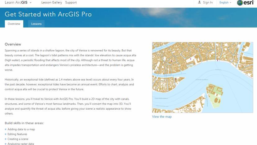
24 Exercises Tutorial Lesson Links: ArcGIS Pro Quick-Start Tutorials Get Started with ArcGIS Pro (Venice Tutorial) Getting Started with ArcGIS Pro (Northridge EarthQuake) Extract Roof forms for Municipal Development Calculate Impervious Surfaces from Spectral Imagery Fly Through South America in a 3D Animation Classify Land Cover to Measure Shrinking Lakes
25 Licensing ArcGIS Pro


26 Licensing Single Use Named User Concurrent Use

27 ArcGIS Pro Licensing ArcGIS Online Named User ArcGIS Enterprise Single Use Concurrent Use Access Pro the best way for your organization

")
28 ArcGIS Pro Licensing Named User Anytime / anyplace - Up to 3 machines Grant access by user Control product level and extensions Re-assign licenses Know who is using what and when ArcGIS Online or Enterprise Web GIS (Online/Enterprise) ArcGIS Pro

29 Named User Licensing in ArcGIS Online/Enterprise Add members to your organization Users who need an ArcGIS Pro license must first be a member of the organization Organization tab > Invite Members ArcGIS Pro requires that members have a Level 2 account
30 ArcGIS Pro Licensing Single Use Perpetual or Term Locked to your machine Online or Offline Secure
31 ArcGIS Pro Licensing Concurrent Use Perpetual License Manager - Requires version 10.5.x - Separate provisioning files On-premises \ Your network Online \ Offline Secure Available for existing Concurrent Use customers
32 What extensions are available with ArcGIS Pro? Spatial Analyst 3D Analyst Network Analyst Geostatistical Analyst Data Reviewer Workflow Manager Data Interoperability StreetMap Premium Pipeline Referencing Defense Mapping Aviation Airports
33 Virtualizing ArcGIS Pro


34 On-premise Virtualization Virtualization Platform VMWare - ESXi - Horizon View Citrix - XenServer - XenDesktop

35 Cloud-based Virtualization Microsoft Azure NV-Series VM - Nvidia GPU - 56 Gb Memory Gb storage - Demo d at Microsoft Ignite AWS GPU Workspace - Nvidia GPU - 8 vcpus - 15 Gb Memory Gb storage Available Now Tested by Esri Performance Engineering Great UX The demo really demonstrated the Workstation in the Cloud scenario that is now really possible with Azure NV based Virtual Machines at Ignite! - Karan Batta, Microsoft Azure
36 ArcGIS Pro Current Status and The Road Ahead
37 ArcGIS Pro Release Timeline Pro 1.0 Pro 1.2 Pro 1.4 Pro 2.1 Pro 2.2 Pro 1.1 Pro 1.3 Pro Pro Pro Pro 2.0 Esri User Conference


38 ArcGIS Pro 2.0 Highlights Create and Edit Annotation Measured Grids in Layout Favorites Dynamic Charts in Layout WFS Standard Support
39 ArcGIS Pro Roadmap Near-term Mid-term Long-term Utility Network Attribute rules Reports Tables in Layouts Full motion video Stereo & Oblique Mensuration Interactive 3D Analysis Real time streaming Offline Web maps & layers SAP HANA Parcel Management Metadata enhancements Exploratory Spatial Data Analysis Dimensions New Extensions Spell Check Animated symbols Presentations Offset printing


40 ArcGIS Ideas Visit ideas.arcgis.com to: - Vote - Comment - Submit new ideas ArcGIS Pro team wants your feedback! - Regular review - Your use case matters - Your ideas can result in new features for everyone Put your Ideas in Motion Visit the ArcGIS Ideas space on GeoNet

41 Responding to your requests and feedback Ideas.ArcGIS.com
42 Analytics/Analysis in ArcGIS Pro

43 Analysis in ArcGIS Pro ArcGIS Pro provides incredible analysis capabilities in 2D, 3D, and 4D (time) Scalable 64-bit execution, non-blocking threading, and improved visualization Geoprocessing is the technology that enables spatial analysis in the ArcGIS Platform that

44 Analysis in ArcGIS Pro The Analysis ribbon tab provides access to Gallery of commonly-used tools Suite of all ~800 geoprocessing tools ArcGIS Enterprise and Online analysis tools Geoprocessing History Python command line ModelBuilder Network Analysis Imagery processing / raster functions Data Interoperability Workbench


45 Charts Use charts to explore your data and communicate a message Include as part of your analysis workflow to: Understand patterns and relationships before running an analysis Communicate information about your analysis results Create a bar chart, scatter plot, histogram, line chart, profile graph or box plot Fully interactive with the map layers and extent, attribute table, and range and time filters


46 Spatial Statistics Statistical tools for analyzing spatial distributions, patterns, processes and relationships Summarize key characteristics of a spatial distribution Identify significant clusters and outliers, hot and cold spots Model and explore spatial relationship through regression Space-Time Pattern Mining Aggregate data into cube data structure and identifies hot and cold spot trends and outliers Visualize the cube in 3D (add-in makes it easy)

47 R-ArcGIS Bridge R is the most widely-used statistical computing language in the world Includes thousands of libraries for diverse applications R-ArcGIS Bridge makes it easy to use GIS data in an R script R-based script tool provides familiar geoprocessing tool for GIS users, but executes in the R engine Requires installation of R and R-ArcGIS bridge

48 R-ArcGIS Bridge

49 Ready to use tools ArcGIS Online Analytical operations hosted by ArcGIS Online, using Esri curated elevation, hydrologic, and street network data Simply provide a few basic inputs Uses ArcGIS.com credits and you must be connected to an ArcGIS online organization with analysis privileges
50 Analysis Extensions Extensions build on the core analysis capabilities of ArcGIS Pro Primarily comprised of additional geoprocessing toolboxes Licensing same as ArcMap Manage extension licenses the same way you license Pro (Named User, Single Use, Concurrent Use)
51 Exercises Desktop Analytics case studies - Determine relationships: - ModelBuilder Tutorial: - R-ArcGIS Bridge:
52 Publishing in ArcGIS Pro
53 Sharing from ArcGIS Pro ArcGIS Online Portal for ArcGIS ArcGIS Server ArcGIS Data Store

54 ArcGIS Pro Sharing User Experience 1. Sign into a portal 2. Share from: i. The ribbon to share your entire map ii. The context menu to share a selection of layers
55 ArcGIS Pro Sharing User Experience 3. Analyze your data for potential issues 4. Click Share/Publish
56 Web Layers and Web Services Portal for ArcGIS ArcGIS Server Web Layer Map Image layer Feature Layer Tile Layer Vector Tile Layer Scene Layer Web Service Dynamic/Cached map service Feature service Cached map service (hosted) Vector tile service Cached scene service
57 Exercises - Sharing - Share a Web Map :
58 Arcade : New Expression Language in ArcGIS Pro
59 What is Arcade? A new expression language for the ArcGIS Platform - ArcGIS Pro - Runtime SDKs - JavaScript API - Web apps Primarily designed for ArcGIS web maps and web scenes
60 Arcade Purpose Arcade is NOT intended to be a Full Programming / Scripting Language Goal : Lightweight and Simple Equivalent to a Spreadsheet Cell Calculation Embedded Expressions Labeling, Rendering, Symbol Variation Sharing Not a replacement for Python for geoprocessing and Automation
61 Arcade Goals Portable Write and Expression in Pro, have it run in a Browser, or on a Device Secure Ensure that Expressions or Scripting do not compromise Security Lightweight Most requirements for Scripts and Expressions are Lightweight. The language should be small, and fast
62 Arcade Resources ArcGIS Arcade Main Site How to Arcade Story Map Introducing Arcade Using Arcade expressions in web apps Using Arcade to map the land How to Arcade Video Using Arcade in your ArcGIS API
63 ModelBuilder in ArcGIS Pro

64
65 Migration from ArcMap ModelBuilder Highlights Make a copy of original toolbox/model before editing in ArcGIS Pro. ModelBuilder models created in ArcGIS Pro are not backwards compatible. To use the models you most save the toolbox of the current version into the version you desire. Calculate Field tool now no longer supports VB expressions. All expressions must now use Python syntax. You will need to update your syntax if your models are saved in VB. All intermediate/managed data options have been removed. All intermediate output data is automatically deleted when tools complete. Except on datasets that are output parameters. In ArcGIS Pro, models have a slightly different color scheme. You cannot change colors, shapes, background images of model elements, and you cannot add images to the model diagram. Models from ArcMap will display these custom settings and objects in ArcGIS Pro when imported. List and series are not support in ArcGIS Pro. You can use iterators to perform batch processes on a collection of datasets Interactive drawing and entering of features or records is not fully supported in ArcGIS Pro

66
67 Migrating to Python 3.X in ArcGIS Pro
68 Analyze Tools for Pro Will my tool just work? Analyze models Toolboxes Python scripts Script tools Built on 2to3 Utility Returns anything not supported with helpful hints as to why
69 Ch-Ch-Changes Arcpy.mapping module is replaced with arcpy.mp to support mapping workflows in ArcGIS Pro Some tools are not available yet or are not supported in ArcGIS Pro. See this link for the not supported list currently. (e.g., parcel fabric arcpy module: arcpy.fabric) A key decision point will be whether you will update your Python code to work in both 10.x and ArcGIS Pro, or just ArcGIS Pro. If you're doing a one-way conversion of code from Python 2 to Python 3, there is a 2to3 command line utility that can be used to automate much of the process. This utility is available with both Python 2 and 3. It is important to note that 2to3, while an excellent tool, is not a complete solution (it is sometimes estimated as a 95 percent solution), and additional changes may be necessary. If you need to support Python 2 and 3, see this link for strategies in supporting both versions
70 ArcGIS API for Python Install with Conda conda install -c esri arcgis Python in the cloud Automate administration of AGOL/ Portal Perform Spatial Analysis/ Data Management in the cloud Create Jupyter Notebooks Learn more at the Dev Docs

71 ArcGIS API for Python
72 Introducing Tasks in ArcGIS Pro
73 Workflow Production Challenges You have told us People are unfamiliar with how to do standard work flows Every user does things differently Hard to maintain Quality Assurance Training time on current / new employees Standard Operating Procedures change or not followed Technology changes rapidly
74 What is a Task? Sequential steps that guide you through a repeatable workflow Tasks: - Used to guide and share knowledge - Are interactive - Improve efficiency - Improve quality Tasks use your (business) language Tasks are configurable The right tool in the right time

75 When NOT to use Tasks? A workflow that takes very long time Task resources keep changing frequently: maps, layers, Geoprocessing tools Micro Management tool Does not replace Geoprocessing models: - Geoprocessing is used for automation - Tasks are interactive


76 INSERT new Task Item A project might contains 0 - many TASK ITEMS that are stored in the APRXfile Use INSERT Task Item Use Save Project to save task modifications Task item Use Package Project to share with a project


77 Create Tasks & Steps Create a task Create steps Group tasks Task Task item name Task steps Task group Designer View


78 General Step Behavior Manual 2 mouse clicks Auto Run / Auto proceed 1 mouse click Automatic no mouse clicks Efficiency
79 Task Resources Workflows in ArcGIS Pro Introduction to Tasks in ArcGIS Pro (video)
80 Exercises - Workflow Control - Share a Web Map : - Create a Task : - Automate Using Tasks: - Getting Started with Arcade:
81 Extending ArcGIS Pro


82 Many Pro SDK Resources Esri Training Instructor-led Esri training course SDK landing page main resource page SDK Wiki on GitHub primary documentation site with concept and guide docs, and much more Community Samples ready to use code solutions categorized by functional area SDK Snippets code snippets by functional area GeoNet Pro SDK Group developer community API Reference full API reference FAQ answers to common questions SDK Blog posts focused on the Pro SDK


83 Solution Configurations Configurations - A new add-in pattern / template at Pro Solution branding of the Pro UI - Conditional or role-based customization Documentation - ProConcepts: - ProGuide:

84 Thank you
Desktop Workflows: An Introduction to ArcGIS Pro. David Watkins, Mark Smithgall
 Desktop Workflows: An Introduction to ArcGIS Pro David Watkins, Mark Smithgall ArcGIS for Desktop Desktop Web Device ArcMap ArcCatalog ArcScene ArcGlobe ArcGIS Pro Portal Server Online Content and Services
Migrating from ArcMap to ArcGIS Pro. David Watkins Scott Noulis
 Migrating from ArcMap to ArcGIS Pro David Watkins Scott Noulis Getting Started with ArcGIS Pro ArcGIS Pro 64 bit, multi-threaded Simplified user interface Integrated with the ArcGIS platform Combined 2D/3D
Nye funktioner i ArcGIS Pro - ArcGIS Pro 2.1
 Nye funktioner i ArcGIS Pro - ArcGIS Pro 2.1 Paulina Karkauskaite GIS Konsulent Paulinak@geoinfo.dk Tlf: +45 53 39 59 16 Niklas Gregersen Presales GIS Konsulent Niklasg@geoinfo.dk Tlf: +45 53 39 59 28
ArcGIS Pro Terminology Guide
 ArcGIS Pro Terminology Guide Essential Terminology or Functionality That s New to ArcGIS Pro ArcGIS Pro Project Map Scene Ribbon Tab on the ribbon View Active view Pane Gallery Task Quick Access Toolbar
ArcGIS Pro Terminology Guide
 ArcGIS Pro Terminology Guide Sharing Terminology and User Interface Cross-Reference Share content Project package (.ppkx) Map package (.mpkx) Layer package (.lpkx) Share or publish a web layer Share Web
ArcGIS Pro. Terminology Guide
 ArcGIS Pro Terminology Guide Essential Terminology or Functionality That s New to ArcGIS Pro ArcGIS Pro Project Map Scene Ribbon Tab on the ribbon View Active view Pane Gallery Task Quick Access Toolbar
ArcGIS Pro: What s New in Editing and Data Management
 Federal GIS Conference February 9 10, 2015 Washington, DC ArcGIS Pro: What s New in Editing and Data Management Robert LeClair ArcGIS Pro Overview Esri FedUC 2015 Technical Workshop ArcGIS Pro: What's
Working with Feature Layers. Russell Brennan Gary MacDougall
 Working with Feature Layers Russell Brennan Gary MacDougall Working with Feature Layers Session will focus on feature access and editing Highlight new features added over the last few releases Agenda Introduction
What s New in Desktop 10.1
 What s New in Desktop 10.1 Damian Spangrud Esri Redlands Trip Down Memory Lane ArcGIS A Complete System for Geographic Information Cloud Web Online Mobile Enterprise Desktop Sharing Information sharing
Enabling High-Quality Printing in Web Applications. Tanu Hoque & Jeff Moulds
 Enabling High-Quality Printing in Web Applications Tanu Hoque & Jeff Moulds Print Service Technical Session Outline What s new in 10.6x What is Print Service Out of the box print solutions Print service
ArcGIS Enterprise: Portal Administration BILL MAJOR CRAIG CLEVELAND
 ArcGIS Enterprise: Portal Administration BILL MAJOR CRAIG CLEVELAND Agenda Welcome & Introduction to ArcGIS Enterprise Portal for ArcGIS - Basic Configuration - Advanced Configuration - Deploying Apps
ArcGIS Enterprise: An Introduction. Philip Heede
 Enterprise: An Introduction Philip Heede Online Enterprise Hosted by Esri (SaaS) - Upgraded automatically (by Esri) - Esri controls SLA Core Web GIS functionality (Apps, visualization, smart mapping, analysis
ArcGIS Pro: Mapping & Visualization. David Watkins, Edie Punt &
 ArcGIS Pro: Mapping & Visualization David Watkins, Edie Punt & Craig Williams @daviddwatkins, @epunt, & @williamscraigm Mapping an Visualization Vision In ArcGIS Pro Improve drawing performance and quality
What s s Coming in ArcGIS 10 Desktop
 What s s Coming in ArcGIS 10 Desktop Damian Spangrud ArcGIS Product Manager, ESRI dspangrud@esri.com (or at least turn to silent) ArcGIS 10 A Simple & Pervasive System for Using Maps & Geographic Information
Troubleshooting Performance Issues with Enterprise Geodatabases. Ben Lin, Nana Dei, Jim McAbee
 Troubleshooting Performance Issues with Enterprise Geodatabases Ben Lin, Nana Dei, Jim McAbee blin@esri.com ndei@esri.com jmcabee@esri.com Workshop Agenda Performance Troubleshooting (Then & Now) Real-World
Sharing Web Layers and Services in the ArcGIS Platform. Melanie Summers and Ty Fitzpatrick
 Sharing Web Layers and Services in the Platform Melanie Summers and Ty Fitzpatrick Agenda Platform overview - Web GIS information model - Two deployment options Pro Sharing - User experience and workflows
Web AppBuilder Presented by
 Web AppBuilder Presented by Agenda Product overview Web AppBuilder for ArcGIS tour What s new in the ArcGIS Online June 2016 update Customization Community and Resources Summary The ArcGIS Platform enables
ArcGIS Desktop The Road Ahead. Amadea Azerki
 ArcGIS Desktop The Road Ahead Amadea Azerki Agenda An Overview of ArcGIS 10 Desktop Enhancements User Interface Mapping Editing Analysis Sharing Q & A ArcGIS 10 Overview Focuses on Usability and Productivity
Developing Add-Ins for ArcGIS Pro (.NET) Toronto Esri Canada UC Presented by: Gandhar Wazalwar & Kern Ranjitsingh October 11, 2018
 Toronto Esri Canada UC Presented by: Gandhar Wazalwar & Kern Ranjitsingh October 11, 2018") Developing Add-Ins for ArcGIS Pro (.NET) Toronto Esri Canada UC Presented by: Gandhar Wazalwar & Kern Ranjitsingh October 11, 2018 Esri Canada Professional Services Project services Implementation services
Developing Add-Ins for ArcGIS Pro (.NET) Toronto Esri Canada UC Presented by: Gandhar Wazalwar & Kern Ranjitsingh October 11, 2018 Esri Canada Professional Services Project services Implementation services
ICIT. Brian Hiller ESRI Account Manger. What s new in ArcGIS 10
 ICIT Brian Hiller ESRI Account Manger What s new in ArcGIS 10 ArcGIS 10 Fast Easy Powerful Everywhere late June 2010 ArcGIS System for Geographic Information Desktop Server Mobile Online A System A Complete
ArcGIS Online. The Road Ahead Geoff Mortson
 ArcGIS Online The Road Ahead Geoff Mortson gmortson@esricanada.com ArcGIS Online Easily create and share maps Delivered as intelligent maps Access on virtually any device anyone, anywhere Compliments and
Administering Your ArcGIS Enterprise Portal Bill Major Craig Cleveland
 Administering Your ArcGIS Enterprise Portal Bill Major Craig Cleveland Agenda Welcome & Introduction to ArcGIS Enterprise Portal for ArcGIS Administration - Basic Configuration - Advanced Configuration
Web AppBuilder for ArcGIS: JavaScript Apps Made Easy
 Web AppBuilder for ArcGIS: JavaScript Apps Made Easy Ryan Sellman @rcsellman Agenda Product overview Web AppBuilder for ArcGIS tour Customization Community and Resources Summary The ArcGIS Platform enables
ArcGIS Online: Best Practices for High-Demand Web Applications. Kelly Gerrow-Wilcox Bonnie Stayer Beth Romero
 ArcGIS Online: Best Practices for High-Demand Web Applications Kelly Gerrow-Wilcox Bonnie Stayer Beth Romero Agenda Communicating with Maps Who do you build your apps for? Layer Types Scalability and Response
Managing Lidar and Photogrammetric Point Clouds. Lindsay Weitz Cody Benkelman
 and Photogrammetric Point Clouds Lindsay Weitz Cody Benkelman Presentation Context What is lidar, and how does it work? Not this presentation! What can you do with lidar in ArcGIS? What does Esri recommend
ArcGIS GeoEvent Server: Making 3D Scenes Come Alive with Real-Time Data
 ArcGIS GeoEvent Server: Making 3D Scenes Come Alive with Real-Time Data Morakot Pilouk, Ph.D. Senior Software Developer, Esri mpilouk@esri.com @mpesri Agenda 1 2 3 4 5 6 3D for ArcGIS Real-Time GIS Static
Data Interoperability An Introduction
 Data Interoperability An Introduction Bruce Harold Dale Lutz - Esri Inc - Safe Software What is the Data Interoperability Extension? Moving data from app to app ETL in industry jargon If you are not the
Scientific and Multidimensional Raster Support in ArcGIS
 Scientific and Multidimensional Raster Support in ArcGIS Sudhir Raj Shrestha sshrestha@esri.com Brief breakdown Scientific Multidimensional data Ingesting Scientific MultiDim Data in ArcGIS Ingesting and
Visualization with ArcGlobe. Brady Hoak
 Visualization with ArcGlobe Brady Hoak Contents What is ArcGlobe? 3D Mapping and ArcGlobe Displaying data in ArcGlobe ArcGlobe tools Tips for constructing ArcGlobe documents New at ArcGIS 9.3 ArcGIS integration
Enabling High-Quality Printing in Web Applications
 Esri Developer Summit March 7 10, 2017 Palm Springs, CA Enabling High-Quality Printing in Web Applications Craig Williams & Tanu Hoque High Quality Printing on the Web Primary Goals: - Create a printable
Enabling High-Quality Printing in Web Applications. Tanu Hoque & Craig Williams
 Enabling High-Quality Printing in Web Applications Tanu Hoque & Craig Williams New Modern Print Service with ArcGIS Enterprise 10.6 Quality Improvements: Support for true color level transparency PDF produced
Configuring ArcGIS Enterprise in Disconnected Environments
 Configuring ArcGIS Enterprise in Disconnected Environments BILL MAJOR Disconnected Environments Not everyone has internet access? How many of you run disconnected today, i.e. no internet access? Many customers
ArcGIS Pro: Effective License Management. Stephanie Wendel Melanie Summers Rob Elkins
 ArcGIS Pro: Effective License Management Stephanie Wendel Melanie Summers Rob Elkins Effective License Management Licensing Model Key Concepts Setting Up and Managing your Organization Grouping Users How
Feature Extraction from Imagery & Lidar. Kurt Schwoppe, Esri Mark Romero, Esri Gregory Bacon, Fairfax County
 Feature Extraction from & Lidar Kurt Schwoppe, Esri Mark Romero, Esri Gregory Bacon, Fairfax County Today s Speakers Image Processing Experts and Good Colleagues Kurt Schwoppe Industry Lead Esri Mark Romero
Introduction to Geodatabase and Spatial Management in ArcGIS. Craig Gillgrass Esri
 Introduction to Geodatabase and Spatial Management in ArcGIS Craig Gillgrass Esri Session Path The Geodatabase - What is it? - Why use it? - What types are there? - What can I do with it? Query Layers
Enabling High-Quality Printing in Web Applications
 Esri Developer Summit March 8 11, 2016 Palm Springs, CA Enabling High-Quality Printing in Web Applications Craig Williams & Tanu Hoque High Quality Printing on the Web Primary Goals: - Create a printable
3D in the Browser with WebGL. Chris Andrews 3D Product Manager Javier Gutierrez 3D Product Engineer
 3D in the Browser with WebGL Chris Andrews 3D Product Manager Javier Gutierrez 3D Product Engineer Just sayin This is not a programming class Goal is to help you learn about a technology area that impacts
ArcGIS 10.1 for Desktop Artie Robinson
 ArcGIS 10.1 for Desktop Artie Robinson ArcGIS A Complete System for Geographic Information Cloud Web Online Mobile Enterprise Desktop Name Change Name Prior to 10.1 ArcGIS Desktop ArcInfo ArcEditor ArcView
Configurations. Charles Macleod Wolfgang Kaiser
 Configurations Charles Macleod Wolfgang Kaiser Configurations Extensibility pattern introduced at 1.4 - All of the functionality of an Add-in plus: - Change the application title and icon - Change the
ICAP - Intelligence Configuration for ArcGIS Pro. Natalie Feuerstein Dan Barnes Joe Bayles
 ICAP - Intelligence Configuration for ArcGIS Pro Natalie Feuerstein Dan Barnes Joe Bayles Overview Intelligence Analyst supporting Operations ArcGIS Pro SDK Intelligence Configuration for ArcGIS Pro -
ArcGIS Enterprise: An Introduction. David Thom Solution Engineer State Government
 ArcGIS Enterprise: An Introduction David Thom Solution Engineer State Government What is ArcGIS Enterprise? ArcGIS Enterprise is server software that allows you to use infrastructure you manage to implement
Dynamic Situational Awareness. Through Developer Applications
 Dynamic Situational Awareness Through Developer Applications Mission Focused Applications Building Apps to support operations Agile Simple High-Performance Defense Developers GIS Simplifies Working With
Making the Most of Raster Analysis with Living Atlas Data. Aileen Buckley, PhD, Research Cartographer Esri - Redlands
 Making the Most of Raster Analysis with Living Atlas Data Aileen Buckley, PhD, Research Cartographer Esri - Redlands Spatial Analysis with Online Data Your Desktop Web Device Never scrounge for or download
What s New in ArcGIS 10.3 for Server. Tom Shippee Esri Training Services
 What s New in ArcGIS 10.3 for Server Tom Shippee Esri Training Services Today s Agenda What is ArcGIS for Server at 10.3 - ArcGIS Platform story - Expanding ArcGIS for Server paradigm What s new in ArcGIS
Cartographic Techniques and Representations
 Cartographic Techniques and Representations NEARC 2007 ESRI Technical Session ESRI, Boston Overview of Presentation Labeling and Annotation Masking Layout Tips Cartographic Representations Labeling versus
ArcGIS Data Reviewer: Ensuring Accurate and Complete Data to Meet Your Mission. John Grammer Kevin Pusey
 ArcGIS Data Reviewer: Ensuring Accurate and Complete Data to Meet Your Mission John Grammer Kevin Pusey Workshop agenda Defining data quality What is ArcGIS Data Reviewer? Automated review Semi-automated
Answer the following general questions: 1. What happens when you right click on an icon on your desktop? When you left double click on an icon?
 Name: Date: June 27th, 2011 GIS Boot Camps For Educators Practical: Explore ArcGIS 10 Desktop Tools and functionality Day_1 Lecture 1 Sources: o ArcGIS Desktop help o ESRI website o Getting to Know ArcGIS
ArcGIS Runtime SDKs Building Offline Apps. Nick Furness
 ArcGIS Runtime SDKs Building Offline Apps Nick Furness Agenda The basics - Considerations - Building blocks - Service types New! Offline maps New! Preplanned workflow What we are covering and what not
Understanding ArcGIS Online - why organizations should embrace the cloud now
 Understanding ArcGIS Online - why organizations should embrace the cloud now Presented to: GeoAlberta - workshop Presented by: David Parry September 25, 2013 Today s Agenda Introduction - Why the Cloud?
ArcGIS Runtime SDK for Qt: Building Apps. Koushik Hajra and Lucas Danzinger
 ArcGIS Runtime SDK for Qt: Building Apps Koushik Hajra and Lucas Danzinger Cross-platform apps Agenda for today Intro to Qt Framework and ArcGIS Runtime SDK for Qt App design patterns with this SDK SDK
Real-Time & Big Data GIS: Leveraging the spatiotemporal big data store
 Real-Time & Big Data GIS: Leveraging the spatiotemporal big data store Suzanne Foss Product Manager, Esri sfoss@esri.com Ricardo Trujillo Real-Time & Big Data GIS Developer, Esri rtrujillo@esri.com @rtrujill007
3D Analysis Tools and Visualization with ArcGIS. Jie Chang Jinwu Ma
 3D Analysis Tools and Visualization with ArcGIS Jie Chang Jinwu Ma Why 3D GIS? Because our world is 3D Improve understanding 3D is easy for everyone to understand Solve 3D problems Some spatial problems
Getting Started with ArcGIS for Server. Charmel Menzel and Ken Gorton
 Getting Started with ArcGIS for Server Charmel Menzel and Ken Gorton Agenda What is ArcGIS for Server? Types of Web services Publishing resources onto the Web Clients to ArcGIS for Server Editions and
ArcGIS for Server Michele Lundeen
 ArcGIS for Server 10.1 Michele Lundeen Summary Vision Installation and Configuration Architecture Publishing Functional Enhancements Cloud Migration and Best Practices Powerful GIS capabilities Delivered
hereby recognizes that Timotej Verbovsek has successfully completed the web course 3D Analysis of Surfaces and Features Using ArcGIS 10
 3D Analysis of Surfaces and Features Using ArcGIS 10 Completed on September 5, 2012 3D Visualization Techniques Using ArcGIS 10 Completed on November 19, 2011 Basics of Map Projections (for ArcGIS 10)
From 2D to 3D at Esri
 From 2D to 3D at Esri OGC/EuroSDR workshop on CityGML in National Mapping Paul Hardy phardy@esri.com Business Development Consultant National Mapping & Cadastre Esri 3D GIS Visualize Manage Share Analyze
ArcGIS for Server Administration. Andrew Sakowicz
 ArcGIS for Server Administration Andrew Sakowicz asakowicz@esri.com Target audience Administrators (GIS, DBA, System) Architects Developers Level: Intermediate Outline Key administrative functions Configuring
Explore some of the new functionality in ArcMap 10
 Explore some of the new functionality in ArcMap 10 Scenario In this exercise, imagine you are a GIS analyst working for Old Dominion University. Construction will begin shortly on renovation of the new
Parallel Python: Multiprocessing With ArcPy. Clinton Dow Geoprocessing Neeraj Rajasekar Spatial Analyst
 Parallel Python: Multiprocessing With ArcPy Clinton Dow Geoprocessing Neeraj Rajasekar Spatial Analyst Agenda What Multiprocessing Is What Multiprocessing Is Not Demo of Multiprocessing Modules - Multiprocessing
Chapter 3 The project
 Chapter 3 The project Background ArcGIS Pro organizes the user experience with data in a completely different way from ArcMap, through a construct known as a project. What is a project? The project is
ArcGIS Runtime SDK for WPF
 Esri Developer Summit in Europe November 9 th Rotterdam ArcGIS Runtime SDK for WPF Mike Branscomb Mark Baird Agenda Introduction SDK Building the Map Query Spatial Analysis Editing and Geometry Programming
Web App Builder: Code-free Development. Adam Ziegler, Esri-Northeast, Local Government Team
 Web App Builder: Code-free Development Adam Ziegler, aziegler@esri.com Esri-Northeast, Local Government Team Agenda Product overview Web AppBuilder for ArcGIS tour Adding Custom Widgets Community and Resources
3D Data Modelling at Esri. Paul Hardy Business Development Consultant Esri Europe
 3D Data Modelling at Esri Paul Hardy phardy@esri.com Business Development Consultant Esri Europe Users of 3D GIS Local government Facilities management Civil engineering 3D GIS Defense / Public Safety
Creating Geoprocessing Services and Web Tools. Darren Baird, PE, Esri
 Creating Geoprocessing Services and Web Tools Darren Baird, PE, Esri Introduction Both ArcMap and ArcGIS Pro are covered Terms Geoprocessing Services and Web Tools are the same - ArcMap publishes geoprocessing
So you haven t upgraded to MapInfo 64-bit yet?
 MapInfo v16 So you haven t upgraded to MapInfo 64-bit yet? This document provides a quick overview of the important features and improvements of the current 64-bit release for those customers who have
Extend GIS. The Reach. Of Your GIS. Chris Cappelli Nathan Bennett
 Extend The Reach GIS Of Your GIS Chris Cappelli Nathan Bennett Where do your co-workers, managers, customers, and citizens go when they want to find or make a map? GIS is a practical system for problem
ArcGIS Enterprise: Sharing Imagery. Zikang Zhou Imagery and Raster team
 ArcGIS Enterprise: Sharing Imagery Zikang Zhou Imagery and Raster team ArcGIS Enterprise: Sharing Imagery PowerPoint slides will be available online. Send me an E-mail if you need it faster: zzhou@esri.com
Geospatial Day II Introduction to ArcGIS Editor for Open Street Map
 Geospatial Day II Introduction to ArcGIS Editor for Open Street Map Geospatial Operations Support Team (GOST) Katie McWilliams kmcwilliams@worldbankgroup.org GOST@worldbank.org 0 Using OSM for Network
Esri UC2013. Technical Workshop. Type Presentation Name Here
 Type Presentation Name Here 2013 Esri International User Conference July 8 12, 2013 San Diego, California Technical Workshop 3D Analyst An Introduction Deepinder Deol Michael Contreras Why use 3D GIS?
ArcGIS Enterprise: Architecting Your Deployment
 ArcGIS Enterprise: Architecting Your Deployment ArcGIS Enterprise ESRI USER CONFERENCE 2017 1 Assumptions and Prerequisites This document assumes you are a system architect or an IT administrator (or work
JANUARY Migrating standalone ArcGIS Server to ArcGIS Enterprise
 JANUARY 2018 Migrating standalone ArcGIS Server to ArcGIS Enterprise Copyright 2018 Esri All rights reserved. Printed in the United States of America. The information contained in this document is the
Getting Started with ArcGIS Runtime SDK for Qt. Thomas Dunn & Nandini Rao
 Getting Started with ArcGIS Runtime SDK for Qt Thomas Dunn & Nandini Rao Agenda Getting Started Creating the Map Geocoding and Routing Geoprocessing Message Processing Work Offline The Next Release ArcGIS
EUCOM/AFRICOM DEFENSE USER GROUP MEETING MARCH 2010 STUTTGART WELCOME!
 EUCOM/AFRICOM DEFENSE USER GROUP MEETING 23-25 MARCH 2010 STUTTGART WELCOME! AGENDA March 23, Tuesday 0800-0900 Registration 0900-0915 Welcome and Introductions 0915-1000 Getting Started with ArcGIS Server
Starter kit - Health GeoLab Collaborative ArcGIS Online platform
 Starter kit - Health GeoLab Collaborative ArcGIS Online platform Version 1.2 (04.09.2018) In collaboration with and with the support of: 0 Revision History Revision Revision Date Comment By 1.0 08 September
Quick Start Guides 1
 1 Core products and components ArcGIS for Desktop........................................... 3 ArcGIS for Server............................................ 5 ArcGIS Engine Developer Kit and ArcGIS Engine................................
Integrating CAD Data with ArcGIS
 Integrating CAD Data with ArcGIS Agenda An Overview of CAD Drawings CAD Data Structure in ArcGIS Visualization Georeferencing Data Conversion ArcGIS for AutoCAD Q & A CAD Drawings - Overview Widely used
ArcGIS Pro SDK for.net Customize Pro to Streamline Workflows. Wolfgang Kaiser
 ArcGIS Pro SDK for.net Customize Pro to Streamline Workflows Wolfgang Kaiser Managed Configuration or Configurations Customize Pro to Streamline Workflows has been implemented with the Managed Configuration
Drone2Map for ArcGIS: Bring Drone Imagery into ArcGIS
 Drone2Map for ArcGIS: Bring Drone Imagery into ArcGIS Mike Sweeney 1 Drone2Map for ArcGIS Turn Drones into Enterprise Productivity Tools ArcGIS Drone2Map for ArcGIS Create 2D and 3D products from raw drone
What s New in Imagery in ArcGIS. Presented by: Christopher Patterson Date: October 18, 2017
 What s New in Imagery in ArcGIS Presented by: Christopher Patterson Date: October 18, 2017 Imagery in ArcGIS Advancing 2010 Stretch, Extract Bands Clip, Mask Reproject, Orthorectify, Pan Sharpen Vegetation
ESRI Technology Update. Joe Holubar Larry Young
 ESRI Technology Update Joe Holubar Larry Young Continued Improvement Improving Quality and Extending and Refining Functionality First Half of 2009: Minor Update Release (ArcGIS 9.3.1) ArcGIS Explorer Fall
ArcGIS Pro SDK for.net: Add-in Fundamentals and Development Patterns. Wolf Kaiser, Uma Harano
 ArcGIS Pro SDK for.net: Add-in Fundamentals and Development Patterns Wolf Kaiser, Uma Harano Session Overview What is the ArcGIS Pro SDK? What is an ArcGIS Pro add-in? ArcGIS Pro Add-ins: - How to write
Understanding and Using Metadata in ArcGIS. Adam Martin Marten Hogeweg Aleta Vienneau
 Understanding and Using Metadata in ArcGIS Adam Martin Marten Hogeweg Aleta Vienneau Adam Martin National Government Account Management R&D Open Data Marten Hogeweg National Government Professional Services
Integrating Imagery into ArcGIS Runtime Application. Jie Zhang, Zhiguang Han San Jacinto, 5:30 pm 6:30 pm
 Integrating Imagery into ArcGIS Runtime Application Jie Zhang, Zhiguang Han San Jacinto, 5:30 pm 6:30 pm Overviews Imagery is an essential component of ArcGIS - Visualization, Processing and Analysis -
Working with Scientific Data in ArcGIS Platform
 Working with Scientific Data in ArcGIS Platform Sudhir Raj Shrestha sshrestha@esri.com Hong Xu hxu@esri.com Esri User Conference, San Diego, CA. July 11, 2017 What we will cover today Scientific Multidimensional
3D in the ArcGIS Platform. Chris Andrews
 3D in the ArcGIS Platform Chris Andrews Geospatial 3D is already all around us 3D is expanding the GIS community s opportunity to provide value 3D City & Infrastructure Models Generated 3D features Photogrammetrc
Designing and Using Cached Map Services
 Esri International User Conference San Diego, California Technical Workshops July 2012 Designing and Using Cached Map Services Sterling Quinn Eric Rodenberg What we will cover Session Topics - Map cache
Imagery and Raster Data in ArcGIS. Abhilash and Abhijit
 Imagery and Raster Data in ArcGIS Abhilash and Abhijit Agenda Imagery in ArcGIS Mosaic datasets Raster processing ArcGIS is a Comprehensive Imagery System Integrating All Types, Sources, and Sensor Models
Desktop. ArcGIS Server. ArcGIS
 Getting Started with ArcGIS Server Nakul Bhatia and David Crosby ESRI Charlotte 1 Agenda g Overview of ArcGIS Server 9.3.1 Working with GIS Services Using g Web GIS Service Clients ArcGIS Online Map Caching
LAB 1: Introduction to ArcGIS 8
 LAB 1: Introduction to ArcGIS 8 Outline Introduction Purpose Lab Basics o About the Computers o About the software o Additional information Data ArcGIS Applications o Starting ArcGIS o o o Conclusion To
ArcGIS Workflows for Optimizing Image Management & Services in the Cloud. Cody A. Benkelman
 ArcGIS Workflows for Optimizing Image Management & Services in the Cloud Cody A. Benkelman Outline Mosaic Datasets Automation with the Mosaic Dataset Configuration Script (MDCS) OptimizeRasters Lower level
No Programming Required Create web apps rapidly with Web AppBuilder for ArcGIS
 No Programming Required Create web apps rapidly with Web AppBuilder for ArcGIS By Derek Law, Esri Product Manager, ArcGIS for Server Do you want to build web mapping applications you can run on desktop,
Automating ArcGIS Deployments Using Chef
 Automating ArcGIS Deployments Using Chef Cherry Lin (clin@esri.com) Bill Major (bmajor@esri.com) David Cordes (dcordes@esri.com) Slides: http://bit.ly/2uieg0p Overview What, Why, When? Esri s Chef Cookbooks
BROWSER. LuciadRIA DATA SHEET
 BROWSER LuciadRIA DATA SHEET V2017 V2017.0 DATA SHEET LuciadRIA is the answer to today s demands for powerful, lightweight applications in the browser. Driven by today s most advanced web technologies,
Managing Imagery and Raster Data using Mosaic Datasets
 Esri European User Conference October 15-17, 2012 Oslo, Norway Hosted by Esri Official Distributor Managing Imagery and Raster Data using Mosaic Datasets Peter Becker ArcGIS is a Comprehensive Imagery
What s New in ArcGIS 10.4 for Server
 What s New in ArcGIS 10.4 for Server Derek Law, Esri Jan 19, 2016 Esri Southwest User Conference Agenda Product story GIS Server Sharing content from ArcGIS Pro Portal for ArcGIS Client Apps Summary Strongly
ArcGIS Runtime SDK for ios and macos: Building Apps. Suganya Baskaran, Gagandeep Singh
 ArcGIS Runtime SDK for ios and macos: Building Apps Suganya Baskaran, Gagandeep Singh Get Started Core Components Agenda - Display Map Content - Search for Content - Perform Analysis - Edit Content Summary
Best Practices for Designing Effective Map Services
 2013 Esri International User Conference July 8 12, 2013 San Diego, California Technical Workshop Best Practices for Designing Effective Map Services Ty Fitzpatrick Tanu Hoque What s in this session Map
FME / ArcGIS 9 Data Interoperability Extension
 FME / ArcGIS 9 Data Interoperability Extension About us Founded: 1993 Head office: Vancouver, Canada # of Employees: 45 Target markets: GIS & GPS vendors, Telecom and utilities, Oil & gas, Government agencies
Developing Qt Apps with the Runtime SDK
 Developing Qt Apps with the Runtime SDK Thomas Dunn and Michael Tims Esri UC 2014 Technical Workshop Agenda Getting Started Creating the Map Geocoding and Routing Geoprocessing Message Processing Work
Developers Road Map to ArcGIS Desktop and ArcGIS Engine
 Developers Road Map to ArcGIS Desktop and ArcGIS Engine Core ArcObjects Desktop Team ESRI Developer Summit 2008 1 Agenda Dev Summit ArcGIS Developer Opportunities Desktop 9.3 SDK Engine 9.3 SDK Explorer