Using ArcGIS Server and ArcGIS Mobile for Disaster Response Putnam County, Florida
|
|
|
- Allyson Hodges
- 5 years ago
- Views:
Transcription
1 Using ArcGIS Server and ArcGIS Mobile for Disaster Response Putnam County, Florida Victoria Smith GIS Programmer/Analyst 1


2 Adjacent counties Clay County, Florida - north St. Johns County, Florida - northeast Flagler County, Florida - east Volusia County, Florida - southeast Marion County, Florida - southwest Alachua County, Florida - west Bradford County, Florida - northwest Established in 1849 Rural County Population 74, Square Miles, 733 of it being land 94 water 2

3 3

4 1. Preliminary Damage Assessments These assessments are a crucial part of the process of determining ng if an event may be declared a major disaster by the president. 2. Public Assistance in Major Disaster Declarations Public Assistance refers to various categories of assistance to state and local governments and non-profit organizations. 3. Individual Assistance in Major Disaster Declarations Individual Assistance includes various forms of help for families and individuals following a disaster event. 4
5 5
6 6
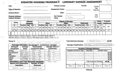
 and total estimate value < (FMV * 0.90) then damage level = Major If total estimate damage >= (FMV * 0.")
7 If total estimate damage < (FMV * 0.50) and total estimate value > 0 then damage level = Minor If total estimate damage >= (FMV * 0.50) and total estimate value < (FMV * 0.90) then damage level = Major If total estimate damage >= (FMV * 0.90) then damage level = Destroyed 7


8 The program needs the following: Needs to collect the data needed to process FEMA forms Need to be able to report initial damage counts Need to collect data for other Putnam County departments Need to be able to view photos within web application Need to be able to efficiently locate yourself in the field 8
9 The program needs the following: Need to be able to edit Needs to be able to use standard symbology. Need to be able to use domain values Need to be able to still collect data in the event of power and network failure NEEDS TO BE EASY FOR NON-GIS PEOPLE TO OPERATE 9

10 ArcGIS Mobile Application(s) Public Web Application Internal Web Application Dashboard(s) 10
11 Control of the interface Make the interface as simplistic as possible Disconnected editing capabilities: Possible situations may occur where there is no power and or internet available Synchronization capabilities Live updates from the field control of data The data available Data appearance data input 11
12 SQL Server sde geodatabase data Accessible by SOC (server object container) GlobalIDs for editing Domains Map document containing data Symbology Data viewing thresholds Published map service Mobile Data Access capability 12
/2008 The ArcGIS 9.")

13 Mobile Application(s) Visual Studio 2005(SP1)/2008 The ArcGIS 9.3 Mobile SDK.NET Framework 2.0 Hardware Laptops using Windows XP Aircards 13
14 Initial Assessment This mobile application is the first response to a disaster. It is used to identify homes, business and all other areas that appear to have damage. Damage Assessment This mobile application is used to do the actual assessment of damaged d properties and businesses. This application allows the user to document d the in-depth questions required to satisfy FEMA. It also allows the user r to collect any required County requested information available at the t same time. 14

15 15
16 16
17 PERTINENT INFORMATION: The following data was made available to the mobile application: Streets INITIAL BUSINESS INITIAL HOUSING Parcel Data 17
18 The Create Mobile BaseMap tool from the Mobile Tools toolbox in ArcToolbox is used to create the base map data. Once the data in created it is added to the application using the Mobile SDK by using the following code: sdclayer = new SdcMapLayer(@"C:\temp temp\mycache\mybasemap.navmap"); MyBaseMap.navmap"); map1.maplayers.add(sdclayer); Note: The.navmap file is created using the Create Mobile BaseMap tool (this file contains information for each extracted layer) 18
19 Zoom in closer to that area. Move around the map with the left mouse button Zoom the map to the initial view so that all the data is visible. Synchronize the field edits of the selected layer in the left panel to the server assuming internet access. Clicking one of these buttons will allow the user to insert a feature into the map designated with Minor, Major, or Destroyed damage in accordance with the chosen button Note: You must select the layer from the panel on the left before clicking on the button 19


20 Data Search Panel 20

21 21
22 PERTINENT INFORMATION: The Create Mobile BaseMap tool from the Mobile Tools toolbox in ArcToolbox is used to create the base The map following data. Once data the was data made in available created to it is the added mobile to application: the application using the Mobile SDK by using the following code: opictures oaccessory Structures sdclayer odamage = new Assessment SdcMapLayer(@"C:\temp ohousing Damage temp\mycache\mybasemap.navmamybasemap.navma p"); obusiness Damage map1.maplayers.add(sdclayer); ostreets oparcel Data Note: The.navmap file is created using the Create Mobile BaseMap tool (this file contains information for each extracted layer) 22

23 Zoom into the map Zoom out of the map Display the data for the feature. ** Move around the map with the left mouse button Full extent of map Deletes a feature from the map ** Insert a feature into the map ** Updates a feature in the map ** Synchronize the field edits of the selected layer in the left panel to the server assuming internet access ** Notes: **You must select the layer from the panel on the left before clicking this button/tool 23
24 24


25 Dwelling Type HomeType Insurance Type Structure Type Roof Type Window Protection Site Tab 25


26 STEP ONE STEP TWO 26
27 27

28 Roof Type Business Type Roof Type Window Protection 28


29 29


30 30


31 Accessory Type Clicking anywhere in the grey area of the form will move the cursor to the first textbox of the form Clicking Close will save the edit and close the form. Clicking Cancel will close the form 31
 Picture")

32 No pictures shown (default) Picture Tool Pictures shown if available 32

33 Picture 1 of 2 Picture 2 of 2 33


34 34


35 Reporting functionality Public interaction Collect non-property specific data Better communication with the field workers 35

36 Thank you for listening QUESTIONS AND COMMENTS 36
A Guide to Using the Planning Office s Interactive Maps
 A Guide to Using the Planning Office s Interactive Maps This guide is intended to assist the user in using the maps provided on the County Planning Office website that are branded as Interactive Maps.
Search & Rescue Map Specifications and Production Workflows
 Search & Rescue Map Specifications and Production Workflows About The Search & Rescue map product and production procedures discussed in this document can be utilized to support search, rescue, and relief
Map Functions August 3, 2015 Triangle Homes Group
 Map Functions August 3, 2015 Triangle Homes Group Preston Neighborhoods and Property Map The Map is an interactive web based using ArcGIS Online by ESRI ESRI is the world s largest Geographic Information
MRMLS SmartMap CityGIS5 (More training available at
 MRMLS SmartMap CityGIS5 (More training available at http://www.imrmls.com/centsite/training.html) 3201 W. Temple Ave., Suite 250 Pomona, Ca 91768 800-925-1525 or http://www.imrmls.com/support Last Edited
Gaston County GIS. Interactive Mapping Website
 Gaston County GIS Interactive Mapping Website The Gaston County GIS mapping website optimizes the available window viewing area and has interactive tools, collapsible menus and movable windows. This map
SAGIS Property Map Viewer Instruction Manual Instructions for using the SAGIS Property Map Viewer. Published December 21, 2018.
 SAGIS Property Map Viewer Instruction Manual www.sagis.org/map Instructions for using the SAGIS Property Map Viewer. Published December 21, 2018. 1 Instructional Videos Click on a link to watch a video
Waushara County Public Access Land Records Viewer Help
 Waushara County Public Access Land Records Viewer Help Main Screen Layout Overview Zoom Pan Controls Parcel Tools Tools Help and Links Image Layers Transition Tools Search Results from Parcel Search Tool
Guide to Mapping Website (Public) December 2016 GC_236594
 December 2016 GC_236594") Guide to Mapping Website (Public) December 2016 GC_236594 Table of Contents Guide to Mapping Website (Public)... 1 December 2016... 1 Quick Start... 3 Map Layers... 4 How do I?... 5 Draw on the Map...
Guide to Mapping Website (Public) December 2016 GC_236594 Table of Contents Guide to Mapping Website (Public)... 1 December 2016... 1 Quick Start... 3 Map Layers... 4 How do I?... 5 Draw on the Map...
Explore some of the new functionality in ArcMap 10
 Explore some of the new functionality in ArcMap 10 Scenario In this exercise, imagine you are a GIS analyst working for Old Dominion University. Construction will begin shortly on renovation of the new
PRELIMINARY DAMAGE ASSESSMENTS INDIVIDUAL ASSISTANCE
 PRELIMINARY DAMAGE ASSESSMENTS INDIVIDUAL ASSISTANCE Jason Ray jason.ray@em.myflorida.com GIS Administrator 850-815-4730 Florida Division of Emergency Management Setup How does FDEM create a Damage Assessments
MODULE 1 BASIC LIDAR TECHNIQUES
 MODULE SCENARIO One of the first tasks a geographic information systems (GIS) department using lidar data should perform is to check the quality of the data delivered by the data provider. The department
Peoria County Front Desk Map Application
 Peoria County Front Desk Map Application Quick Guide, 2017 At a First Glance This guide will tell users all they need to know about the Peoria County Front Desk application which can be found on the Peoria
Geography 281 Mapmaking with GIS Project One: Exploring the ArcMap Environment
 Geography 281 Mapmaking with GIS Project One: Exploring the ArcMap Environment This activity is designed to introduce you to the Geography Lab and to the ArcMap software within the lab environment. Before
P&D GIS Map How-To-Guide Thomas Fire / January 9, 2018 Debris Flow
 P&D GIS Map How-To-Guide The interactive GIS web-based map is available here. Once you have accessed the map, type in your address in the field on the top right corner and click on the magnifying glass
Table of Contents Website Layout Website Tools
 Help Dialogue Welcome to the Vanderburgh County Assessor s Web Map! This website is a very useful resource for searching and research on properties within Vanderburgh County, Indiana. This help dialogue
Lab 1: Exploring ArcMap and ArcCatalog In this lab, you will explore the ArcGIS applications ArcCatalog and ArcMap. You will learn how to use
 Lab 1: Exploring ArcMap and ArcCatalog In this lab, you will explore the ArcGIS applications ArcCatalog and ArcMap. You will learn how to use ArcCatalog to find maps and data and how to display maps in
Basic Tasks in ArcGIS 10.3.x
 Basic Tasks in ArcGIS 10.3.x This guide provides instructions for performing a few basic tasks in ArcGIS 10.3.1, such as adding data to a map document, viewing and changing coordinate system information,
Introduction to GIS & Mapping: ArcGIS Desktop
 Introduction to GIS & Mapping: ArcGIS Desktop Your task in this exercise is to determine the best place to build a mixed use facility in Hudson County, NJ. In order to revitalize the community and take
Chapter 1 : Getting Started with Integrity... Chapter 2 : Interface Layout... Chapter 3 : Navigation... Chapter 4 : Printing...
 .0 User s Manual Table of Contents Chapter : Getting Started with Integrity... Chapter : Interface Layout... Chapter : Navigation... Chapter : Printing... Chapter : Quick Search and Results Pane... Results
v SMS 11.1 Tutorial GIS Requirements GIS Module Map Module ArcGis (Optional) Time minutes Prerequisites None Objectives
 Time minutes Prerequisites None Objectives") v. 11.1 SMS 11.1 Tutorial GIS Objectives This tutorial demonstrates how you can read in GIS data, visualize it, and convert it into SMS coverage data that could be used to build a numeric model. We will
v. 11.1 SMS 11.1 Tutorial GIS Objectives This tutorial demonstrates how you can read in GIS data, visualize it, and convert it into SMS coverage data that could be used to build a numeric model. We will
Full Search Map Tab Overview
 FlexMLS Map Server Full Search Map Tab Overview The Full Search Map tab is a need to know module. It is accessible when you use Full Search under Search in the Main Menu tree of FlexMLS. This map can
Geography 281 Mapmaking with GIS Project One: Exploring the ArcMap Environment
 Geography 281 Mapmaking with GIS Project One: Exploring the ArcMap Environment This activity is designed to introduce you to the Geography Lab and to the ArcMap software within the lab environment. Please
Intro to GIS (requirements: basic Windows computer skills and a flash drive)
") Introduction to GIS Intro to GIS (requirements: basic Windows computer skills and a flash drive) Part 1. What is GIS. 1. System: hardware (computers, devices), software (proprietary or free), people. 2.
Introduction to GIS Intro to GIS (requirements: basic Windows computer skills and a flash drive) Part 1. What is GIS. 1. System: hardware (computers, devices), software (proprietary or free), people. 2.
This guide will tell you all you need to know about the new Front Desk application which can be found on the main Peoria County GIS website.
 New Front Desk Quick Guide, 2014 At a First Glance This guide will tell you all you need to know about the new Front Desk application which can be found on the main Peoria County GIS website. When you
PREMIER DATA CENTER OPPORTUNITY ±64.31 ACRES OF LAND ENGLER BLVD AND HWY 212 Chaska, MN 55318
 -$2.50/GROSS SF CLOVER PRESERVE DR PROPERTY HIGHLIGHTS + + Preliminary plat approved. Data center site, shovel ready + + 25MW service to the site via adjacent, double-ended substation with multiple feeds
Huerfano County GIS Portal User Guide
 Huerfano County GIS Portal User Guide Table of Contents What is a geoportal? 1 Using Huerfano County GIS portal 1 Navigating the map builder 5 Working with Layers 6 Using the Query Tool 7 Printing Maps
GeoGIS User Guide Draft 8/13/15
 GeoGIS User Guide Draft 8/13/15 Table of Contents Chapter 1: Introduction. 2 1.1 GeoGIS User Types...2 Chapter 2: General User Type...3 2.1 Login Page...3 2.2 GeoGIS Homepage.4 2.3 GeoGIS Map 5 2.4 Family
CVEN 2012 GEOMATICS LAB SPRING 2016 INTRO TO ESRI ARCGIS
 CVEN 2012 GEOMATICS LAB SPRING 2016 INTRO TO ESRI ARCGIS Objectives 1. Download and Add Data into ArcMap 2. Symbolize and Label Features 3. Navigate and Investigate the Map 4. Explore Attributes and Metadata
Lesson 2 - Analyzing Census Data Using USA Demographics for Schools
 Lesson 2 - Analyzing Census Data Using USA Overview: Students will learn how to navigate USA Demographics for Schools. Students will apply their learning to develop a demographic profile of their community.
Tutorial for Lane County Mapping Applications
 Tutorial for Lane County Mapping Applications Contents Overview... 2 Tools... 2 Navigation Tools... 3 Display Tools... 5 Information Tools... 6 Sharing Tools... 7 Common Tasks... 9 Identify or Show Data
Newaygo County Web Map
 Newaygo County Web Map Address/Parcel/Parcel Owner Search Map Overview Zoom Back to default extent Use your current location if allowable Widget Panel At the top of the map is a search function used for
FlexMLS Maps Quick Reference Guide
 FlexMLS Maps Quick Reference Guide Full Search Map Tab Features Define Search Areas box Map tab in Full Search Radius Search tool from an address Show/Hide Property List, Locate Address, and Define Search
City of La Crosse Online Mapping Website Help Document
 City of La Crosse Online Mapping Website Help Document This document was created to assist in using the new City of La Crosse online mapping sites. When the website is first opened, a map showing the City
REDI 5.0 User Manual
 REDI 5.0 User Manual OBJECTIVE: REDI (Regional Economic Development Information System) provides a quick, convenient and easy way of accessing the City of San Diego Business Incentive Zones (BIZ) information.
Locating the Structural High from 2D Seismic Data
 Locating the Structural High from 2D Seismic Data Brian Gille 5-6-10 The goal of this project was to interpolate a surface that represented the depth to a surface that was picked on a 2D seismic survey.
Geographical Information Systems Institute. Center for Geographic Analysis, Harvard University. LAB EXERCISE 1: Basic Mapping in ArcMap
 Harvard University Introduction to ArcMap Geographical Information Systems Institute Center for Geographic Analysis, Harvard University LAB EXERCISE 1: Basic Mapping in ArcMap Individual files (lab instructions,
ARC HYDRO GROUNDWATER TUTORIALS
 ARC HYDRO GROUNDWATER TUTORIALS details to cross sections Arc Hydro Groundwater (AHGW) is a geodatabase design for representing groundwater datasets within ArcGIS. The data model helps to archive, display,
Geospatial Day II Introduction to ArcGIS Editor for Open Street Map
 Geospatial Day II Introduction to ArcGIS Editor for Open Street Map Geospatial Operations Support Team (GOST) Katie McWilliams kmcwilliams@worldbankgroup.org GOST@worldbank.org 0 Using OSM for Network
1. NJDEP Landscape 3.3 Viewer Interface
 Using the Landscape Project through NJDEP Landscape 3.3 Viewer Google Chrome or Mozilla Firefox are recommended for the use of this app. Navigate to the NJDEP-DFW s Landscape Project web page at www.njfishandwildlife.com/ensp/landscape/
Chapter 5. Presenting Data
 Chapter 5. Presenting Data Copyright McGraw-Hill Education. Permission required for reproduction or display. 5-1 Map Design Process 5-2 1 About ArcGIS Chapter 5. Presenting Data 5-3 Page layouts and map
Introduction to ArcPad
 Introduction to ArcPad Jennifer McKee Prepared by: With support from: NSF DUE-090270 in partnership with: Mobile GIS Allows field staff to capture, update, analyze spatial data Extends reach of the office
Map Viewer User Guide
 Map Viewer User Guide Sea Level Scenario Sketch Planning Tool Version 2, 2017 University of Florida GeoPlan Center Introduction The purpose of this document is to guide users on how to use the Sea Level
Exercise 1: An Overview of ArcMap and ArcCatalog
 Exercise 1: An Overview of ArcMap and ArcCatalog Introduction: ArcGIS is an integrated collection of GIS software products for building a complete GIS. ArcGIS enables users to deploy GIS functionality
George Mason University Department of Civil, Environmental and Infrastructure Engineering
 George Mason University Department of Civil, Environmental and Infrastructure Engineering Dr. Celso Ferreira Prepared by Lora Baumgartner December 2015 Revised by Brian Ross July 2016 Exercise Topic: GIS
GIS LAB 8. Raster Data Applications Watershed Delineation
 GIS LAB 8 Raster Data Applications Watershed Delineation This lab will require you to further your familiarity with raster data structures and the Spatial Analyst. The data for this lab are drawn from
Linear Referencing in ArcGIS. GIS by ESRI
 Linear Referencing in ArcGIS GIS by ESRI Copyright 00 ESRI All rights reserved. Printed in the United States of America. The information contained in this document is the exclusive property of ESRI. This
Welcome, please click on the hyperlink below to be directed to Sacramento County Online Maps. Survey's GIS Online Map
 Welcome, please click on the hyperlink below to be directed to Sacramento County Online Maps. Survey's GIS Online Map If the link does not work copy and paste the following address into your browser address
Manitowoc County, WI Advanced Access GIS Viewer User Documentation
 Manitowoc County, WI Advanced Access GIS Viewer User Documentation Introduction Extensive time was put into developing this website both from a display, and from a printing and scaling perspective. This
Designing and Using Basemaps. Jennifer Hughey
 Designing and Using Basemaps Jennifer Hughey Agenda The ArcGIS System Basemaps are a key component of your system Cartographic design considerations Using basemap layers in ArcMap Best practices for designing
Read and accept the following disclaimer:
 How to use the Person County Tax Parcel Viewer Visit gis.personcounty.net and click to view the Tax Parcel Viewer or go to gis.personcounty.net/taxparcelviewer Read and accept the following disclaimer:
Making Schools Smarter and Safer Using Geographic Information Systems
 Making Schools Smarter and Safer Using Geographic Information Systems Presented By Albert Koenigsberg President of GEOcommand, INC. Florida Educational Facilities Planners Association 07/10/2018 Old School
AAPOR 2013 Methodological Briefs: Cell Phones. Howard Speizer, Marcus Berzofsky, Tom Duffy, Jamie Ridenhour (RTI) Tim Sahr (Ohio State University)
 Tim Sahr (Ohio State University)") Alternative Sample Selection and Data Collection Strategies for Balancing Cell Phone Response Distribution Across County/Region Level Geographies in a Dual Frame Telephone Survey AAPOR 2013 Methodological
Alternative Sample Selection and Data Collection Strategies for Balancing Cell Phone Response Distribution Across County/Region Level Geographies in a Dual Frame Telephone Survey AAPOR 2013 Methodological
Lab 3: Digitizing in ArcGIS Pro
 Lab 3: Digitizing in ArcGIS Pro What You ll Learn: In this Lab you ll be introduced to basic digitizing techniques using ArcGIS Pro. You should read Chapter 4 in the GIS Fundamentals textbook before starting
RAPIDMAP Geocortex HTML5 Viewer Manual
 RAPIDMAP Geocortex HTML5 Viewer Manual This site was developed using the evolving HTML5 web standard and should work in most modern browsers including IE, Safari, Chrome and Firefox. Even though it was
Using Collector for ArcGIS and Operations Dashboard for ArcGIS. Mike Sweeney Esri-Charlotte
 Using Collector for ArcGIS and Operations Dashboard for ArcGIS Mike Sweeney Esri-Charlotte Agenda The ArcGIS Platform Desktop Web Device Portal Cloud Server Online Content and Services On-Premises Available
Collector for ArcGIS
 Collector for ArcGIS Field GIS Taking GIS Beyond the Office Collecting Data Reporting Observations Managing Work Connecting the Field with the Enterprise Field Mobility Solutions Improve accuracy and currency
Full Search Map Tab. This map is the result of selecting the Map tab within Full Search.
 Full Search Map Tab This map is the result of selecting the Map tab within Full Search. This map can be used when defining your parameters starting from a Full Search. Once you have entered your desired
What s New in Desktop 10.1
 What s New in Desktop 10.1 Damian Spangrud Esri Redlands Trip Down Memory Lane ArcGIS A Complete System for Geographic Information Cloud Web Online Mobile Enterprise Desktop Sharing Information sharing
Number Screen Element. App Lake County Logo: Displays the logo for Lake County, Colorado.
 The Main Screen When you open any of the Lake County maps, a screen similar to the one below will appear. The buttons at the bottom will vary between maps, the order will remain similar. Number Screen
ArcMap - EXPLORING THE DATABASE Part I. SPATIAL DATA FORMATS Part II
 Week 5 ArcMap - EXPLORING THE DATABASE Part I SPATIAL DATA FORMATS Part II topics of the week Exploring the Database More on the Table of Contents Exploration tools Identify, Find, Measure, Map tips, Hyperlink,
v SMS 12.1 Tutorial GIS Requirements GIS Module Map Module ArcGis (Optional) Time minutes Prerequisites None Objectives
 Time minutes Prerequisites None Objectives") v. 12.1 SMS 12.1 Tutorial Objectives This tutorial demonstrates how to read in data, visualize it, and convert it into SMS coverage data that could be used to build a numeric model. This tutorial will
v. 12.1 SMS 12.1 Tutorial Objectives This tutorial demonstrates how to read in data, visualize it, and convert it into SMS coverage data that could be used to build a numeric model. This tutorial will
Three Cases for Using the ArcGIS Server Out-of-the-Box Technology
 Three Cases for Using the ArcGIS Server Out-of-the-Box Technology Sarah Schrader Goodhue County GIS Specialist GIS/LIS Fall Conference - Thursday, October 14 th, 2010 Duluth, MN BACKGROUND Small Government
ArcGIS 10.1 for Desktop Artie Robinson
 ArcGIS 10.1 for Desktop Artie Robinson ArcGIS A Complete System for Geographic Information Cloud Web Online Mobile Enterprise Desktop Name Change Name Prior to 10.1 ArcGIS Desktop ArcInfo ArcEditor ArcView
Using analytical tools in ArcGIS Online to determine where populations vulnerable to flooding and landslides exist in Boulder County, Colorado.
 Using analytical tools in ArcGIS Online to determine where populations vulnerable to flooding and landslides exist in Boulder County, Colorado. Estimated Time to complete: 1-2 hours Learning Objective:
Butler County Property Ownership Website. Help Document
 Table of Contents Butler County Property Ownership Website Help Document Introduction... 1 Overview of Home Page... 1 Navigation & Tools... 2 Upper Right:...4 Layer List... 4 Draw... 4 Measurement... 6
What's New in ArcGIS 9.2 Service Packs
 What's New in ArcGIS 9.2 Service Packs 18 July 2007 Updated for Service Pack 3 This document describes the main enhancements to 9.2 added by the service packs. It does not cover the bug fixes and quality
HOW TO FILL YOUR DATA INTO THE LOCAL GOVERNMENT INFORMATION MODEL. Jeremy Williams City of Clearwater 2014 ESRI User Conference / Presentation UC460
 HOW TO FILL YOUR DATA INTO THE LOCAL GOVERNMENT INFORMATION MODEL Jeremy Williams City of Clearwater 2014 ESRI User Conference / Presentation UC460 WHAT IS THE LOCAL GOVERNMENT INFORMATION MODEL? LGIM
APPENDIX G. VMT Spreadsheet Tool. FINAL REPORT Improved Data & Tools for Integrated Land Use-Transportation Planning in California TOPICS:
 FINAL REPORT Improved Data & Tools for Integrated Land Use-Transportation Planning in California APPENDIX G VMT Spreadsheet Tool TOPICS: 1. Overview of Tool 2. Code Documentation 3. User Guide 4. Validation
GIS Exercise 10 March 30, 2018 The USGS NCGMP09v11 tools
 GIS Exercise 10 March 30, 2018 The USGS NCGMP09v11 tools As a result of the collaboration between ESRI (the manufacturer of ArcGIS) and USGS, ESRI released its Geologic Mapping Template (GMT) in 2009 which
Ottawa County Survey Data Map
 Ottawa County Engineer s Office User Guide for Ottawa County Survey Data Map Introduction: The Ottawa County Engineer s Office has been diligently working to better serve our constituents with access to
Lab 11: Terrain Analyses
 Lab 11: Terrain Analyses What You ll Learn: Basic terrain analysis functions, including watershed, viewshed, and profile processing. There is a mix of old and new functions used in this lab. We ll explain
MICA High Water Mark Mapping Project What WE Learned Mission Assignment 4222DR-OK-COE-SWD-01/02
 MICA High Water Mark Mapping Project What WE Learned Mission Assignment 4222DR-OK-COE-SWD-01/02 Disaster DR-4222 Oklahoma Severe Storms, Tornadoes, Straight-line Winds, and Flooding Major Disaster Declaration
START>PROGRAMS>ARCGIS>
 Department of Urban Studies and Planning Spring 2006 Department of Architecture Site and Urban Systems Planning 11.304J / 4.255J GIS EXERCISE 2 Objectives: To generate the following maps using ArcGIS Software:
ESRI Mobile GIS Solutions Overview. Justin Fan
 ESRI Mobile GIS Solutions Overview Justin Fan Agenda Mobile GIS challenges ESRI Mobile GIS solutions ArcPad ArcGIS Mobile ArcGIS Engine Selecting a mobile GIS solution Q & A Objective To help you select
GIS Basics for Urban Studies
 GIS Basics for Urban Studies Date: March 21, 2018 Contacts: Mehdi Aminipouri, Graduate Peer GIS Faciliator, SFU Library (maminipo@sfu.ca) Keshav Mukunda, GIS & Map Librarian Librarian for Geography (kmukunda@sfu.ca)
Getting to Know ModelBuilder
 Getting to Know ModelBuilder Offered by Shane Bradt through the UNH Cooperative Extension Geospatial Technologies Training Center Developed by Sandy Prisloe and Cary Chadwick at the Geospatial Technology
Each primary search has an auto-fill that will filter out results as the user continues to type.
 The Town of Farmville has recently requested a GIS parcel viewer and Timmons Group, based out of Richmond, VA, was selected to design and host this new website. This website allows users to look up parcel
Complete instructions for using the. Planners Map. in ArcGIS Online (
 Complete instructions for using the Planners Map in ArcGIS Online (www.arcgis.com) Overview of the Planners Map The Planners Map provides interested parties with information on tax parcels, shoreland zoning,
Urban vs Rural Selection Tool
 Urban vs Rural Selection Tool This tool was developed to aid in determination of whether a project/facility location is considered to be urban or rural per EPA s guidance. The tool allows the identification
Free to download and distribute from
 Topics for this session Introduction Overview of features Using ArcGIS Explorer effectively Customization New features & capabilities Demonstrations *Note: Explorer 1200 What is ArcGIS Explorer GIS for
Florida Birth-to-Five Child Outcomes Measurement System
 TATS Tips For Running the Macro-LES 2017-2018 What IS a Macro? A Macro is a series of commands and functions that are stored and can be run whenever you need to perform the task. (Microsoft Office) The
The ArcGIS platform CHAPTER 1. Introduction LEARNING GOALS
 CHAPTER The ArcGIS platform LEARNING GOALS Get an introduction to the ArcGIS platform. Get an introduction to the ArcGIS Pro user interface. Learn to navigate maps. Work with tables of attribute data.
DSD GIS Viewer 2.0 DSD/ IIO
 DSD GIS Viewer 2.0 DSD/ IIO DSD Viewer II Below are instructions for using the viewer. The viewer can be found at https://maps.hillsboroughcounty.org/dsd/dsd.html The DSD Viewer provides regulatory and
New Mexico Watch: User Guide
 New Mexico Watch: User Guide The New Mexico Watch (nmwatch.org) interactive website distributes maps, data, and related information of natural disasters within New Mexico. This application is developed
Editing Parcel Fabrics Tutorial
 Editing Parcel Fabrics Tutorial Copyright 1995-2010 Esri All rights reserved. Table of Contents Tutorial: Getting started with parcel fabric editing...................... 3 Tutorial: Creating new parcels
OnCOR Silverlight Viewer Guide
 Getting Around There are many ways to move around the map! The simplest option is to use your mouse in the map area. If you hold the left button down, then click and drag, you can pan the map to a new
ICIT. Brian Hiller ESRI Account Manger. What s new in ArcGIS 10
 ICIT Brian Hiller ESRI Account Manger What s new in ArcGIS 10 ArcGIS 10 Fast Easy Powerful Everywhere late June 2010 ArcGIS System for Geographic Information Desktop Server Mobile Online A System A Complete
The New Enhancements in ModelBuilder in ArcGIS 10
 The New Enhancements in ModelBuilder in ArcGIS 10 Article ID : TT100036 Software : ArcGIS Desktop 10 Platform : Windows XP, Windows Vista, Windows 7 Date : 1 st May, 2011 Introduction ModelBuilder is a
1. Start ArcMap by going to the Start menu > All Programs > ArcGIS > ArcMap.
 Learning ArcGIS: Introduction to ArcMap 10.1 The Map Document Feature Manipulation Navigating ArcMap Map Documents, Layers, and Features Shapes, Location, and Attribute Data Symbology Zoom, Pan and Map
Lab 11: Terrain Analyses
 Lab 11: Terrain Analyses What You ll Learn: Basic terrain analysis functions, including watershed, viewshed, and profile processing. There is a mix of old and new functions used in this lab. We ll explain
ArcGIS Runtime SDK for WPF
 Esri Developer Summit in Europe November 9 th Rotterdam ArcGIS Runtime SDK for WPF Mike Branscomb Mark Baird Agenda Introduction SDK Building the Map Query Spatial Analysis Editing and Geometry Programming
Getting Started with the new GIS Map Service Overview:
 Getting Started with the new GIS Map Service Overview: 1. Layer List Widget Shows all available layers. This widget will be open by default. 2. Legend Widget Gives symbology information for all visible
The University of Arizona
 1 The University of Arizona Campus 360 Web Map Help Guide v 1.3.1 Revised Aprils 2018 https://maps.arizona.edu/campus360/ 2 CONTENTS INTRODUCTION MAP CONTROLS Zoom in, zoom out...p. 4 Map Control toolbar
Raster Serving with ArcGIS
 Raster Serving with ArcGIS Agenda Introduction to server technology Workflow considerations ESRI raster serving technology ArcGIS Server Basic (ArcSDE) ArcGIS Server Standard/Advanced Web Services ArcGIS
Southwest Florida Water Management District Application and Response Submittal Guide
 Southwest Florida Water Management District To submit electronically go to: Access the statewide permitting portal at: www.watermatters.org/permits http://floridawaterpermits.com Application and Response
Field-Scale Watershed Analysis
 Conservation Applications of LiDAR Field-Scale Watershed Analysis A Supplemental Exercise for the Hydrologic Applications Module Andy Jenks, University of Minnesota Department of Forest Resources 2013
Using the ESRI Collector App: A User s Manual
 Using the ESRI Collector App: A User s Manual Produced by Jim Groot and Carrie Thomas Edited by Erik Cammeraat, Harry Seijmonsbergen and Thijs de Boer Summer 2017 1 Contents Introduction... 3 Getting Started...
Collector for ArcGIS: What s New. Chris LeSueur & James Tedrick
 Collector for ArcGIS: What s New Chris LeSueur & James Tedrick Outline Product overview Workflows Preparing data for Collector for ArcGIS What s new in Collector for ArcGIS v18.1.0 (Aurora) Advanced topics
Overview of Server Technologies. Katja Krivoruchko ESRI
 Overview of Server Technologies Katja Krivoruchko ESRI Agenda Introduction to Server Technology Workflow Considerations ESRI Server Technology ArcSDE ArcGIS Server ArcGIS Image Server File Server Implementation
Pre-Incident Planning ( PIP )
") Pre-Incident Planning ( PIP ) Presentation Overview 1) Web GIS Terminology Review 2) Technical Details of PIP 3) The Start of PIP 4) PIP & General Maintenance Currently 1 year old Dashboards & Python 5)
Pre-Incident Planning ( PIP ) Presentation Overview 1) Web GIS Terminology Review 2) Technical Details of PIP 3) The Start of PIP 4) PIP & General Maintenance Currently 1 year old Dashboards & Python 5)