Introduction to Bentley PondPack
|
|
|
- Raymond Leonard
- 6 years ago
- Views:
Transcription
1 Introduction to Bentley PondPack CE 365K Hydraulic Engineering Design Prepared by Cassandra Fagan and David Maidment Spring 2015 Contents Goals of the Tutorial... 1 Procedure... 1 (1) Opening Bentley PondPack... 1 (2) Entering Storm Data... 3 (3) Laying out the Detention Pond Network... 5 (4) Entering Watershed Data... 6 (5) Entering Stage-Area data for the Detention Pond... 7 (6) Entering Outlet Data and Creating an Outlet Discharge Rating Curve... 8 (7) Routing the Hydrograph through the Detention Pond (8) Editing the Outlet Structure Properties Goals of the Tutorial This tutorial will introduce you to the capabilities of Bentley PondPack. This includes creating a Detention Pond Network, routing a hydrograph through the system, and graphing results. Procedure (1) Opening Bentley PondPack Open the program by double-clicking the FlowMaster icon on your desktop, seen below, or click Start > All Programs > Bentley > PondPack, and select PondPack. In the Welcome to Bentley PondPack dialog bog select Create New Project. 1


2 If a dialog box appears asking whether you would like to create Pre/Post-Development analysis scenarios now, select No. Save the project by selecting File > Save As from the menu bar. Navigate to the folder you will be using and select Save. Enter the project information by selecting File > Project Properties under the File menu. Before beginning a project, you should configure the units and drawing settings. Select Tools > Options in the menu bar. Select the Units tab, and change the Default Unit System for New Project to US. Then click the Reset Defaults tab and select US Customary. 2


3 Next, select the Drawing tab in the Options Window. Click the drop-down arrow next to the Drawing Mode tab, and select Schematic. This allows you to draw a schematic of the detention pond network without worrying about sizes and node lengths. Click OK to close out of the Options Window. (2) Entering Storm Data For this tutorial, water from a storm event, modeled as an inflow hydrograph, will be routed through a detention pond and outlet. To begin, you will need to specify the Storm Event. A 10- year, 2-hour storm event with a fall depth of 4.5 inches, with synthetic distribution data from the Illinois State Water Survey Bulletin 70/71 will be used in this analysis. To specify this storm event, navigate to Components > Storm Data in the menu bar, and in the Storm Data window select the New button, and click Time-Depth. Under the Storm Event Input seen in the central window, select the new button, seen below, and select Add Return Event from Dimensionless Curve. The Engineering Libraries window will appear on the screen. Expand the Dimensionless Rainfall Curves tab and expand the Bul70-71.xml tab. Select the stQ 50% option, and click Select, pictured below. This design storm will use first-quartile statistics from storm events with return intervals of 10 years or less. 3


4 A Generate Storm Event Window will appear on the screen, pictured below. Enter Bulletin 70/71 as the Curve Label, enter 10 years for Return Event, select Cumulative in the Depth Type drop-down menu. Enter 4.5 inches as the New Depth, 2.0 Hours as the New Duration, and select OK. In the Storm Data window select Close. In the top menu bar select Components > Global Storm Data in the menu bar. In the Global Storm Data Window, click the drop down menu under the Global Storm Even tab, and select Time-Depth- 1 (Bulletin 70/71)- 10 Year. Click Close to close the Global Storm Data window. 4

5 (3) Laying out the Detention Pond Network The Detention Pond Network will consist of a drainage area contributing a detention pond and draining to a detention pond outlet. To draw this schematic, begin by selecting the Catchment button on the vertical toolbar. In the upper left corner of the workspace draw a catchment by left-clicking to draw vertices. Finish by right-clicking and selecting Done. A catchment labeled CM-1 should appear in the workspace. Select the Pond button from the vertical menu bar and in the center of the workspace area draw a pond by left-clicking to draw corners. Right-click and select Done to finish the pond. A pond labeled PO-1 should appear in the workspace. Select the Layout button and select Pond Outlet from the drop-down menu. On the Right-Side of the Pond, PO-1, left-click to create a pond outlet entrance, POE-1. Move the cursor away from the pond, right-click, select Outfall, and left-click to create the Outfall, O-1. Click select to exit layout mode. Double click on the Catchment, CM-1, and the Properties window will appear on the screen. Next to Outflow Node, select the drop-down menu and click Select Outflow Node. In the schematic click on the pond, PO-1, and PO-1 will appear as the Outflow Node in the Properties window. Double-click on the pond outlet entrance, POE-1, to open the Properties window. Select the drop-down arrow next to Upstream Pond, and click Select Upstream Pond, and in the schematic select PO-1. Close the Properties window. The pond network schematic is pictured below. 5
6 (4) Entering Watershed Data To enter watershed data, double-click on the catchment, CM-1, in the schematic to open the Properties window. The catchment has an area of 10 acres, a runoff curve number of 80 and a time of concentration of 30 minutes. Under the Rainfall section of the Properties window click the drop-down arrow next to Use Local Rainfall? and select True. A line below it should appear, and next to Local Storm Event, select Time-Depth- 1 (Bulletin 70/71)- 10 Year in the drop-down menu. The Rainfall section is pictured below. In the Runoff section, next to Runoff Method select Unit Hydrograph from the drop-down menu. Set the Loss Method to SCN CN in the drop down menu. Next to Use Scaled Area? select False, and enter 80 acres as the Area (User Defined). Set the CN Input Type to Simple CN and next to SCS CN enter a value of 80. Set the Unit Hydrograph method to SCS Unit Hydrograph, the Tc Input Type should be set to User Defined Tc, and enter 0.5 hours as the Time of Concentration. The runoff section of the catchment properties window is pictured below. Once this information is entered, close the CM-1 Properties window. 6

7 (5) Entering Stage-Area data for the Detention Pond Elevation-Area Data for Detention Pond Elevation (ft) Area (ac) Elevation (ft) Area (ac) Double click on the detention pond PO-1 to open the Properties window. Under the Volume section, set the Pond Type to Elevation-Area. Next to Elevation-Area, click the ellipsis button. In the Elevation-Area window, enter the pond Elevation-Area data found in the table above. When you complete entering the data, close out of the Elevation-Area window, and close out of the PO-1 properties window. 7
 Entering Outlet Data and Creating an Outlet Discharge Rating Curve The pond outlet, Outlet 1, has two outlets operating in parallel.")
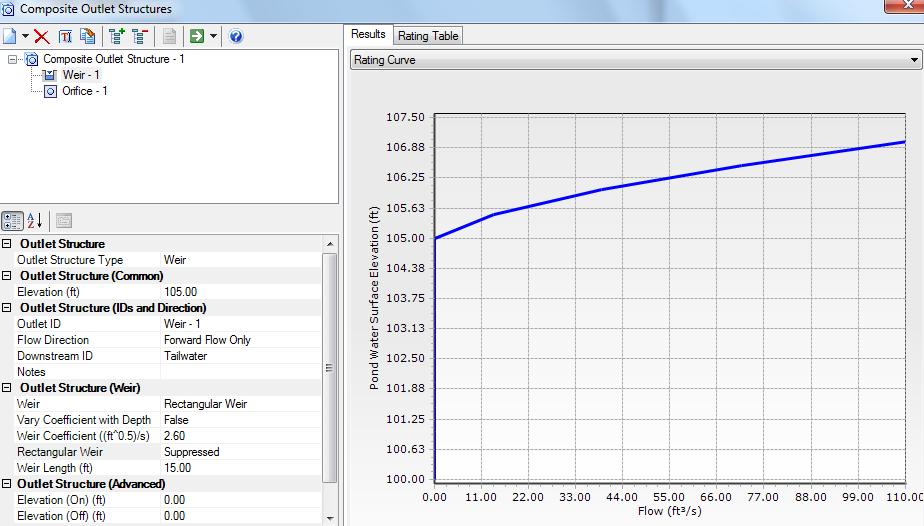
8 Right-click on PO-1, and select Pond Volume Results Table to view a graph of the detention pond s Elevation versus Volume curve. Select the Data Table tab to view the data for the curve. Close out of the Volume Results Table window. (6) Entering Outlet Data and Creating an Outlet Discharge Rating Curve The pond outlet, Outlet 1, has two outlets operating in parallel. One outlet is a rectangular, contracted weir with a weir coefficient of 2.6. The weir structure is 15 feet wide, and has an elevation of feet. The second outlet consists of a 6-inch diameter orifice plate at an elevation of feet and an orifice coefficient of 0.6. Both outlets operate under free outfall conditions. Double click Outlet-1, to open the properties window. In the Pond Outlet section, next to Has Control Structure? select Yes. On the Composite Outlet Structure line, click the drop-down arrow and select Edit. A Composite Outlet Structures window will appear on the screen. In the upper-left corner of the window, click the New button and select Composite Outlet Structure. A composite Outlet Structures window will come up on the screen. In the Headwater section, click next to Pond and click Select from Drawing from the drop-down menu. Select the detention pond, PO-1, in the main window. In the upper-left corner of the Composite Outlet Structure window, click the New button and select Weir from the drop-down menu. Enter feet as the Elevation in the Outlet Structure section. Select Forward Flow Only as the Flow Direction in the Outlet Structure (IDs and Direction) section. 8
 section, enter 100 feet for the Elevation (ft).")

9 In the Outlet Structure section, next to Weir select Rectangular Weir. Set the Weir Coefficient to 2.6, set Rectangular Weir to Suppressed, and set the Weir Length to 15 feet. The Weir properties are pictured below. In the upper-left corner click the New button, and select Orifice. In the Outlet Structure (Common) section, enter 100 feet for the Elevation (ft). In the Outlet Structure (IDs and Direction) section, set the Flow Direction to Forward Flow Only. Under the Outlet Structure (Orifice) section set the Orifice to Circular Orifice. Set the Orifice Coefficient to 0.6, and set the Orifice Diameter to 6.0 inches. The orifice window is pictured below. In the top of the Composite Outlet Structures Window highlight Composite Outlet Structure-1 and select the Compute button. 9


10 A Rating Curve plotting Pond Water Surface Elevation versus Flow will appear on the right side of the Composite Outlet Structures window. Close the Composite Outlet Structures window. In the Pond Outlet Properties window, Pond Outlet section set the Composite Outlet Structure to Composite Outlet Structure- 1 using the drop-down menu. Close out of the Properties window. (7) Routing the Hydrograph through the Detention Pond The Detention Pond model is now ready for the hydrograph routing. Select the Validate button to check for any errors in the model. If no validation issues are found, select OK in the window pictured below. Select the Compute button. The model will run to completion, and a Scenario Calculation Summary window will appear on the screen. Review the summary and select close. In the menu bar, select Analysis > User Notifications to see if there would any errors during the model run. Right click on the detention pond, PO-1, and select Graph. In the Graph Series Options window there are three sections, Scenarios, Elements, and Fields. In the Fields panel, select Volume and Elevation and select OK. Note the many variables that can be plotted. A Graph will appear on the screen plotting Volume and Elevation versus Time. To view the data used to create the chart select the Data tab. 10
, change its properties, and recompute the Rating Table using the compute button in the display.")
11 (8) Editing the Outlet Structure Properties Double click on the Pond Element in the Drawing, and in the Pond Properties, select the Outlet Double Click on the Composite Outlet Structure and select <Edit> Select the Weir (or Orifice), change its properties, and recompute the Rating Table using the compute button in the display. Go back to the main Pond Pack window and recompute the flow through the system. 11
12 12
Watershed Modeling Rational Method Interface. Learn how to model urban areas using WMS' rational method interface
 v. 10.1 WMS 10.1 Tutorial Learn how to model urban areas using WMS' rational method interface Objectives Learn how to model urban areas using the Rational method, including how to compute rainfall intensity,
Bentley OpenRoads Workshop 2017 FLUG Fall Training Event
 Bentley OpenRoads Workshop 2017 FLUG Fall Training Event F-1P - Designing with a Pond Bentley Systems, Incorporated 685 Stockton Drive Exton, PA 19341 www.bentley.com Practice Workbook This workbook is
WMS 10.0 Tutorial Storm Drain Modeling SWMM Modeling Learn how to link a hydrologic model to the SWMM storm drain model
 v. 10.0 WMS 10.0 Tutorial Learn how to link a hydrologic model to the SWMM storm drain model Objectives Build a rational method hydrologic model and compute sub-basin flows. Import storm drain network
WMS 9.1 Tutorial Storm Drain Modeling SWMM Modeling Learn how to link a hydrologic model to the SWMM storm drain model
 v. 9.1 WMS 9.1 Tutorial Learn how to link a hydrologic model to the SWMM storm drain model Objectives Build a rational method hydrologic model and compute sub-basin flows. Import storm drain network information
Learn how to link a hydrologic model to the SWMM storm drain model
 v. 10.1 WMS 10.1 Tutorial Learn how to link a hydrologic model to the SWMM storm drain model Objectives Build a rational method hydrologic model and compute sub-basin flows. Import storm drain network
WMS 10.0 Tutorial Watershed Modeling MODRAT Interface Schematic Build a MODRAT model by defining a hydrologic schematic
 v. 10.0 WMS 10.0 Tutorial Watershed Modeling MODRAT Interface Schematic Build a MODRAT model by defining a hydrologic schematic Objectives This tutorial shows users how to define a basic MODRAT model using
This loads a preset standard set of data appropriate for Malaysian modeling projects.
 XP Software On-Site Detention (OSD) Example Step 1 Open xpswmm2010 program Or from Start menu select Programs XPS - then select xpswmm2010 Select Create From Template Save file, e.g. Filename.xp The program
Watershed Modeling HEC-HMS Interface
 v. 10.1 WMS 10.1 Tutorial Learn how to set up a basic HEC-HMS model using WMS Objectives Build a basic HEC-HMS model from scratch using a DEM, land use, and soil data. Compute the geometric and hydrologic
WMS 8.4 Tutorial Watershed Modeling MODRAT Interface Schematic Build a MODRAT model by defining a hydrologic schematic
 v. 8.4 WMS 8.4 Tutorial Watershed Modeling MODRAT Interface Schematic Build a MODRAT model by defining a hydrologic schematic Objectives This tutorial shows you how to define a basic MODRAT model using
Storm Drain Modeling HY-12 Rational Design
 v. 10.1 WMS 10.1 Tutorial Learn how to design storm drain inlets, pipes, and other components of a storm drain system using FHWA's HY-12 storm drain analysis software and the WMS interface Objectives Define
Ducks on the Pond: Stormwater Management Basin Analysis Using AutoCAD Civil 3D and Autodesk SSA
 Ducks on the Pond: Stormwater Management Basin Analysis Using AutoCAD Civil 3D and Autodesk Josh Kehs, P.E. Autodesk, Inc. CI4541 Learning Objectives At the end of this class, you will be able to: Model
Build a MODRAT model by defining a hydrologic schematic
 v. 11.0 WMS 11.0 Tutorial Build a MODRAT model by defining a hydrologic schematic Objectives Learn how to define a basic MODRAT model using the hydrologic schematic tree in WMS by building a tree and defining
WMS 10.0 Tutorial Hydraulics and Floodplain Modeling HY-8 Modeling Wizard Learn how to model a culvert using HY-8 and WMS
 v. 10.0 WMS 10.0 Tutorial Hydraulics and Floodplain Modeling HY-8 Modeling Wizard Learn how to model a culvert using HY-8 and WMS Objectives Define a conceptual schematic of the roadway, invert, and downstream
Evaluating Multiple Stormwater Analysis and Design Alternatives with StormCAD
 Evaluating Multiple Stormwater Analysis and Design Alternatives with StormCAD Workshop Overview In this workshop you will use StormCAD to analyze an existing storm sewer system. You will add a parking
Multi-Stage Outlet Structures
 Methods in Stormwater Management Using HydroCAD Multi-Stage Outlet Structures H09 Multi-Stage Outlet Structures.pdf 1 Topics 1. Multi-State Outlet Structures Definition 2. Orifice and Weir Equations 3.
Hydrologic Modeling using HEC-HMS
 Hydrologic Modeling using HEC-HMS CE 412/512 Spring 2017 Introduction The intent of this exercise is to introduce you to the structure and some of the functions of the HEC-Hydrologic Modeling System (HEC-HMS),
Storm Drain Modeling HY-12 Pump Station
 v. 10.1 WMS 10.1 Tutorial Storm Drain Modeling HY-12 Pump Station Analysis Setup a simple HY-12 pump station storm drain model in the WMS interface with pump and pipe information Objectives Using the HY-12
Modeling Detention Ponds Malaysian Example (v2009)
") Modeling Detention Ponds Malaysian Example (v2009) This tutorial demonstrates the usability of xpswmm and xpstorm for simulating detention basins in urban areas. This fictitious example includes the use
Modeling Detention Ponds Malaysian Example (v2009) This tutorial demonstrates the usability of xpswmm and xpstorm for simulating detention basins in urban areas. This fictitious example includes the use
v. 9.1 WMS 9.1 Tutorial Watershed Modeling HEC-1 Interface Learn how to setup a basic HEC-1 model using WMS
 v. 9.1 WMS 9.1 Tutorial Learn how to setup a basic HEC-1 model using WMS Objectives Build a basic HEC-1 model from scratch using a DEM, land use, and soil data. Compute the geometric and hydrologic parameters
Hydraulics and Floodplain Modeling Modeling with the Hydraulic Toolbox
 v. 9.1 WMS 9.1 Tutorial Hydraulics and Floodplain Modeling Modeling with the Hydraulic Toolbox Learn how to design inlet grates, detention basins, channels, and riprap using the FHWA Hydraulic Toolbox
Objectives Divide a single watershed into multiple sub-basins, and define routing between sub-basins.
 v. 11.0 HEC-HMS WMS 11.0 Tutorial HEC-HMS Learn how to create multiple sub-basins using HEC-HMS Objectives Divide a single watershed into multiple sub-basins, and define routing between sub-basins. Prerequisite
WMS 8.4 Tutorial Watershed Modeling MODRAT Interface (GISbased) Delineate a watershed and build a MODRAT model
 Delineate a watershed and build a MODRAT model") v. 8.4 WMS 8.4 Tutorial Watershed Modeling MODRAT Interface (GISbased) Delineate a watershed and build a MODRAT model Objectives Delineate a watershed from a DEM and derive many of the MODRAT input parameters
v. 8.4 WMS 8.4 Tutorial Watershed Modeling MODRAT Interface (GISbased) Delineate a watershed and build a MODRAT model Objectives Delineate a watershed from a DEM and derive many of the MODRAT input parameters
WinSLAMM v 10.0 User s Guide. Input/Output
 WinSLAMM v 10.0 User s Guide Input/Output Printing the Input Printing the Input To Print the Input data, select File, then Print Input Data Printing the Input Select the desired options and then select
WinTR-55 for Plan Reviewers Small Watershed Hydrology
 WinTR-55 for Plan Reviewers Small Watershed Hydrology Modeling Single Sub-area Watersheds (Part 1) 1 Course Outline Overview Review of Hydrology Terms Modeling Single Sub-area Watersheds Modeling Single
Storm Drain Modeling HY-12 Analysis with CAD
 v. 10.1 WMS 10.1 Tutorial Storm Drain Modeling HY-12 Analysis with CAD Data Setup an HY-12 storm drain model in the WMS interface using CAD data with inlet and pipe information Objectives Learn to define
v. 8.4 Prerequisite Tutorials Watershed Modeling Advanced DEM Delineation Techniques Time minutes
 v. 8.4 WMS 8.4 Tutorial Modeling Orange County Rational Method GIS Learn how to define a rational method hydrologic model for Orange County (California) from GIS data Objectives This tutorial shows you
Cross Sections, Profiles, and Rating Curves. Viewing Results From The River System Schematic. Viewing Data Contained in an HEC-DSS File
 C H A P T E R 9 Viewing Results After the model has finished the steady or unsteady flow computations the user can begin to view the output. Output is available in a graphical and tabular format. The current
Spatial Hydrologic Modeling HEC-HMS Distributed Parameter Modeling with the MODClark Transform
 v. 9.0 WMS 9.0 Tutorial Spatial Hydrologic Modeling HEC-HMS Distributed Parameter Modeling with the MODClark Transform Setup a basic distributed MODClark model using the WMS interface Objectives In this
SRH-2D Additional Boundary Conditions
 v. 12.2 SMS 12.2 Tutorial SRH-2D Additional Boundary Conditions Objectives Learn techniques for using various additional boundary conditions with the Sedimentation and River Hydraulics Two-Dimensional
v Modeling Orange County Unit Hydrograph GIS Learn how to define a unit hydrograph model for Orange County (California) from GIS data
 from GIS data") v. 10.1 WMS 10.1 Tutorial Modeling Orange County Unit Hydrograph GIS Learn how to define a unit hydrograph model for Orange County (California) from GIS data Objectives This tutorial shows how to define
v. 10.1 WMS 10.1 Tutorial Modeling Orange County Unit Hydrograph GIS Learn how to define a unit hydrograph model for Orange County (California) from GIS data Objectives This tutorial shows how to define
Modeling CULTEC Chambers in HydroCAD - Using the Chamber Wizard
 Modeling CULTEC Chambers in HydroCAD - Using the Chamber Wizard The chamber wizard (added in HydroCAD-9) is a revolutionary tool for doing underground storage layout and modeling. In just a few steps you
WinSLAMM v 10.2 User s Guide
 WinSLAMM v 10.2 User s Guide Batch Editor, Cost Analysis, pre Development Runoff Volume Calculation lationandand Creating a Model File from a Data File Batch Editor Running a Set of Files Batch Editor
Tutorial 6 - Subdivision - Pre Development
 Tutorial 6 - Subdivision - Pre Development In this tutorial, you will learn about: 2. 3. 4. 5. 6. 7. 8. 9. 10. 2. Using a Template Adding a Background Image and Using the Zoom Tool Creating Nodes Creating
Storm Drain Modeling Defining HY-12 Storm Drain Networks with Shapefiles and LandXML files
 WMS 10.1 Tutorial v. 10.1 Storm Drain Modeling Defining HY-12 Storm Drain Networks with Shapefiles and LandXML files Set up an HY-12 storm drain model in the WMS interface using common file types such
MODRET VERSION 6.0 FOR WINDOWS 95. Setup Hydrograph Infiltration Routing Graphic Windows ReadMe
 MODRET VERSION 6.0 FOR WINDOWS 95 EXPLANATIONS FOR MENU COMMAND OPTIONS FIRST SCREEN PROMPT Setup Hydrograph Infiltration Routing Graphic Windows ReadMe Select one of these options using the mouse and
Linear Routing: Floodrouting. HEC-RAS Introduction. Brays Bayou. Uniform Open Channel Flow. v = 1 n R2/3. S S.I. units
 Linear Routing: Floodrouting HEC-RAS Introduction Shirley Clark Penn State Harrisburg Robert Pitt University of Alabama April 26, 2004 Two (2) types of floodrouting of a hydrograph Linear Muskingum Reservoir
Watershed Modeling Orange County Hydrology Using GIS Data
 v. 9.1 WMS 9.1 Tutorial Watershed Modeling Orange County Hydrology Using GIS Data Learn how to delineate sub-basins and compute soil losses for Orange County (California) hydrologic modeling Objectives
Watershed Modeling Advanced DEM Delineation
 v. 10.1 WMS 10.1 Tutorial Watershed Modeling Advanced DEM Delineation Techniques Model manmade and natural drainage features Objectives Learn to manipulate the default watershed boundaries by assigning
H y d r o C A D. Owner's Manual
 H y d r o C A D Stormwater Modeling System Version 8 Owner's Manual Copyright 2006 HydroCAD Software Solutions LLC. All rights reserved. HydroCAD is a registered trademark of HydroCAD Software Solutions
v SMS 11.1 Tutorial SRH-2D Prerequisites None Time minutes Requirements Map Module Mesh Module Scatter Module Generic Model SRH-2D
 v. 11.1 SMS 11.1 Tutorial SRH-2D Objectives This lesson will teach you how to prepare an unstructured mesh, run the SRH-2D numerical engine and view the results all within SMS. You will start by reading
v Modeling Orange County Rational Method GIS Learn how to define a rational method hydrologic model for Orange County (California) from GIS data
 from GIS data") v. 10.1 WMS 10.1 Tutorial Modeling Orange County Rational Method GIS Learn how to define a rational method hydrologic model for Orange County (California) from GIS data Objectives This tutorial shows how
v. 10.1 WMS 10.1 Tutorial Modeling Orange County Rational Method GIS Learn how to define a rational method hydrologic model for Orange County (California) from GIS data Objectives This tutorial shows how
Spatial Hydrologic Modeling Using NEXRAD Rainfall Data in an HEC-HMS (MODClark) Model
 Model") v. 10.0 WMS 10.0 Tutorial Spatial Hydrologic Modeling Using NEXRAD Rainfall Data in an HEC-HMS (MODClark) Model Learn how to setup a MODClark model using distributed rainfall data Objectives Read an existing
v. 10.0 WMS 10.0 Tutorial Spatial Hydrologic Modeling Using NEXRAD Rainfall Data in an HEC-HMS (MODClark) Model Learn how to setup a MODClark model using distributed rainfall data Objectives Read an existing
Appendix E-1. Hydrology Analysis
 Appendix E-1 Hydrology Analysis July 2016 HYDROLOGY ANALYSIS For Tentative Tract 20049 City of Chino Hills County of San Bernardino Prepared For: 450 Newport Center Drive, Suite 300 Newport Beach, CA 92660
SiphoniTec. User s Guide
 SiphoniTec A Siphonic Roof Drainage Design Utility The Level Approach to Roof Drainage User s Guide Release 2.0 RAINWATER MANAGEMENT SOLUTIONS 1260 West Riverside Drive Salem, Virginia 24153 Telephone:
PCSWMM 2002 RUNOFF Block PAT AVENUE Storm Drainage Design
 PCSWMM 2002 RUNOFF Block PAT AVENUE Storm Drainage Design A Hello World Example Prepared by Robert Pitt and Alex Maestre, Department of Civil Engineering, University of Alabama April 10, 2002 Introduction
LD20493 From AutoCAD Civil 3D to Storm and Sanitary Analysis - Pond Design Using Volume-Grading Tools
 LD20493 From AutoCAD Civil 3D to Storm and Sanitary Analysis - Pond Design Using Volume-Grading Tools Kevin Larkin LSC Design, Inc. Learning Objectives Learn how to dynamically model stormwater ponds using
Objectives This tutorial shows you how to define data for and run a rational method model for a watershed in Orange County.
 v. 9.0 WMS 9.0 Tutorial Modeling Orange County Rational Method GIS Learn how to define a rational method hydrologic model for Orange County (California) from GIS data Objectives This tutorial shows you
Objectives This tutorial demonstrates how to perform unsteady sediment transport simulations in SRH-2D.
 SMS v. 12.2 SRH-2D Tutorial Objectives This tutorial demonstrates how to perform unsteady sediment transport simulations in SRH-2D. Prerequisites SMS Overview tutorial SRH-2D SRH-2D Sediment Transport
Watershed Modeling Maricopa Predictive HEC-1 Model. Watershed Modeling Maricopa County: Master Plan Creating a Predictive HEC-1 Model
 v. 10.1 WMS 10.1 Tutorial Watershed Modeling Maricopa County: Master Plan Creating a Predictive HEC-1 Model Build a watershed model to predict hydrologic reactions based on land use development in Maricopa
Watershed Analysis Lab Heterogeneous, Gaged Watershed I (Northwest Branch)
") Watershed Analysis Lab Heterogeneous, Gaged Watershed I (Northwest Branch) The previous lab demonstrated the process of selecting quadrangles, specifying data types, delineating a watershed, and using
Watershed Analysis Lab Heterogeneous, Gaged Watershed I (Northwest Branch) The previous lab demonstrated the process of selecting quadrangles, specifying data types, delineating a watershed, and using
PCSWMM 2002 EXTRAN Block PAT AVENUE Storm Drainage Design
 PCSWMM 2002 EXTRAN Block PAT AVENUE Storm Drainage Design A Hello World Example Prepared by Dr. Robert Pitt and Jason Kirby, Department of Civil Engineering, University of Alabama August 20, 2002 Introduction
ISIS Free & ISIS Professional Quick Start Guide
 ISIS Free & ISIS Professional Cost effective, integrated modelling solutions Think saving, think ISIS, think Halcrow This quick start guide enables first time users to quickly understand how to use ISIS
Watershed Modeling Using Online Spatial Data to Create an HEC-HMS Model
 v. 10.1 WMS 10.1 Tutorial Watershed Modeling Using Online Spatial Data to Create an HEC-HMS Model Learn how to setup an HEC-HMS model using WMS online spatial data Objectives This tutorial shows how to
Required: 486DX-33, 8MB RAM, HDD w. 20 MB free, VGA, Win95. Recommended: Pentium 60, 16 MB RAM, SVGA, Win95 or NT
 Evaluation Form Evaluator Information Name: Jeff Hagan Date: Feb. 17, 2000 Software Information Title of Software: Purpose: Publisher: CulvertMaster Culvert Hydraulic Design Haestad Methods, Inc. Version:
Objectives Read a delineated watershed and setup and run an HSPF model for the watershed.
 v. 10.1 WMS 10.1 Tutorial Setup a basic HSPF model Objectives Read a delineated watershed and setup and run an HSPF model for the watershed. Prerequisite Tutorials Watershed Modeling DEM Delineation Watershed
ISIS 1D. Quick Start Guide. Cost effective, integrated software solutions ch2mhill.com/isis
 ISIS 1D Quick Start Guide Cost effective, integrated software solutions 0845 094 7990 ch2mhill.com/isis softwaresupport@ch2m.com Table of Contents Overview... 3 1. Starting ISIS and Basic Concepts... 3
Culvert Studio User's Guide
 Culvert Studio User's Guide 2 Culvert Studio Table of Contents Foreword 0 Part I Introduction 5 1 Installing... and Activating 6 2 Getting... Updates 7 3 About... This Guide 7 Part II Overview 9 1 The
Objectives Read a delineated watershed and setup and run an HSPF model for the watershed.
 v. 9.1 WMS 9.1 Tutorial Setup a basic HSPF model Objectives Read a delineated watershed and setup and run an HSPF model for the watershed. Prerequisite Tutorials Watershed Modeling DEM Delineation Watershed
Tutorial Hydrodynamics in sewers
 Tutorial Hydrodynamics in sewers September 2007 3.9230.00 Tutorial Hydrodynamics in sewers September 2007 Tutorial Hydrodynamics in sewers 3.9230.00 September 2007 Contents 1 Tutorial Hydrodynamics in
USING HYDRODESKTOP TO FIND DATA FOR WATERSHED HYDROLOGY
 USING HYDRODESKTOP TO FIND DATA FOR WATERSHED HYDROLOGY Exercise 4 February 10, 2011 by: Gonzalo E. Espinoza, Dr. Tim Whiteaker, and Dr. David Maidment Center for Research in Water Resources The University
Watershed Modeling Maricopa County: Master Plan Creating a Predictive HEC-1 Model
 v. 9.0 WMS 9.0 Tutorial Watershed Modeling Maricopa County: Master Plan Creating a Predictive HEC-1 Model Build a watershed model to predict hydrologic reactions based on land use development in Maricopa
George Mason University Department of Civil, Environmental and Infrastructure Engineering
 George Mason University Department of Civil, Environmental and Infrastructure Engineering Dr. Celso Ferreira Prepared by Lora Baumgartner December 2015 Revised by Brian Ross July 2016 Exercise Topic: Getting
CEE3430 Engineering Hydrology
 CEE3430 Engineering Hydrology Homework 8. Step by Step Guidance for using HEC HMS to solve homework problems 1. Solve Part 1, problem 3 above using HEC-HMS. The standard lag referred to in the inputs (and
Storm Water Management Model User's Manual Version 5.1
 United States Environmental Protection Agency EPA/600/R-14/413b Revised September 2015 - www2.epa.gov/water-research - Storm Water Management Model User's Manual Version 5.1 Office of Research and Development
WMS 10.1 Tutorial GSSHA Modeling Basics Post-Processing and Visualization of GSSHA Model Results Learn how to visualize GSSHA model results
 v. 10.1 WMS 10.1 Tutorial GSSHA Modeling Basics Post-Processing and Visualization of GSSHA Model Results Learn how to visualize GSSHA model results Objectives This tutorial demonstrates different ways
WMS 9.1 Tutorial GSSHA Modeling Basics Post-Processing and Visualization of GSSHA Model Results Learn how to visualize GSSHA model results
 v. 9.1 WMS 9.1 Tutorial GSSHA Modeling Basics Post-Processing and Visualization of GSSHA Model Results Learn how to visualize GSSHA model results Objectives This tutorial demonstrates different ways of
v Water Distribution System Modeling Working with WMS Tutorials Building a Hydraulic Model Using Shapefiles Prerequisite Tutorials None
 v. 10.1 WMS 10.1 Tutorial Water Distribution System Modeling Working with EPANET Building a Hydraulic Model Using Shapefiles Objectives Open shapefiles containing the geometry and attributes of EPANET
Section 3 Laying Out Structures
 Mastering Storm&Sanitary Section 3 Laying Out Structures Section Goals: How to Set Drainage Options When to Set Structure Settings Using Preference Sets Laying Out Ditch Inlets Laying Out a connecting
Water Distribution System Modeling EPANET. Import an existing water distribution model and modify link and node parameters within WMS
 v. 10.1 WMS 10.1 Tutorial Water Distribution System Modeling EPANET Hydraulic Model Import an existing water distribution model and modify link and node parameters within WMS Objectives View an existing
URBAN & RURAL RUNOFF ROUTING APPLICATION GETTING STARTED MANUAL
 URBAN & RURAL RUNOFF ROUTING APPLICATION GETTING STARTED MANUAL Copyright 2013 XP Solutions. All right reserved. No part of this publication maybe reproduced in any form by any means without the written
EPANET Tutorial. Project Setup Our first task is to create a new project in EPANET and make sure that certain default options are selected.
 EPANET Tutorial Example Network In this tutorial we will analyze the simple distribution network shown below. It consists of a source reservoir (e.g., a treatment plant clearwell) from which water is pumped
xpwspg 2010 Modeling
 xpwspg 2010 Modeling The xpwspg capability in XP s products includes building/enhancing WSPG models with GIS/CAD data and presenting models with various graphical outputs. In this tutorial, users will
Drainage Design Exercise. Computer-based Subsurface Design
 Drainage Design Exercise Computer-based Subsurface Design OBJECTIVES Introduction of the LANDRAIN software: a program for subsurface drainage design. During last year's cropping season, a farmer, Mr. Igro
VDOT GEOPAK Drainage Training Manual
 VDOT GEOPAK Drainage Training Manual Training Manual 2004 Edition TRN007630-1/0002 Trademarks AccuDraw, Bentley, the B Bentley logo, MDL, MicroStation and SmartLine are registered trademarks; PopSet and
Volume 4. Carlson Hydrology 2007 Carlson Natural Regrade Carlson Software Inc.
 Carlson Software 2007 Volume 4 Carlson Hydrology 2007 Carlson Natural Regrade 2007 Carlson Software Inc. User s manual August 8, 2006 Contents Chapter 1. Hydrology Module 1 Surface Menu....................................
PowerPoint Launching PowerPointX
 PowerPoint 2004 Launching PowerPointX 1. Start PowerPoint by clicking on the PowerPoint icon in the dock or finding it in the hard drive in the Applications folder under Microsoft Office 2004. PowerPoint
WMS 9.1 Tutorial GSSHA Modeling Basics Stream Flow Integrate stream flow with your GSSHA overland flow model
 v. 9.1 WMS 9.1 Tutorial Integrate stream flow with your GSSHA overland flow model Objectives Learn how to add hydraulic channel routing to your GSSHA model and how to define channel properties. Learn how
SurvCADD Hydrology Module
 SurvCADD Hydrology Module Overview The Hydrology Module consists of several routines that work together in sequence. This manual only explains the operation of the commands and not hydrology concepts.
PACIFIC CENTER Anaheim, California
 HYDROLOGY REPORT PACIFIC CENTER Anaheim, California Prepared for Hines Company 4000 MacArthur Blvd. Suite 110 Newport Beach, CA 92660 949.313.2230 Prepared by Fuscoe Engineering, Inc. 16795 Von Karman,
Module 9. Lecture 3: Major hydrologic models-hspf, HEC and MIKE
 Lecture 3: Major hydrologic models-hspf, HEC and MIKE Major Hydrologic Models HSPF (SWM) HEC MIKE Hydrological Simulation Program-Fortran (HSPF) Commercial successor of the Stanford Watershed Model (SWM-IV)
STORM WATER MANAGEMENT MODEL USER S MANUAL. Version 5.0
 November 2004 STORM WATER MANAGEMENT MODEL USER S MANUAL Version 5.0 By Lewis A. Rossman Water Supply and Water Resources Division National Risk Management Research Laboratory Cincinnati, OH 45268 NATIONAL
OpenRoads Creating Subsurface Utility Models
 OpenRoads Creating Subsurface Utility Models Existing and Proposed Utilities Presenter: Robert Garrett, PE Bentley Systems, Incorporated 685 Stockton Drive Exton, PA 19341 www.bentley.com Before you Begin:...
APPENDIX B STEP-BY-STEP APPLICATIONS OF THE FEMWATER-LHS
 APPENDIX B STEP-BY-STEP APPLICATIONS OF THE FEMWATER-LHS Steady Two-Dimensional Drainage Problem 1. Double-click on the Argus ONE icon to open Argus ONE. 2. From the PIEs menu found along the top of the
Work with the Google Folder App
 Work with the Google Folder App Blackboard Web Community Manager Trademark Notice Blackboard, the Blackboard logos, and the unique trade dress of Blackboard are the trademarks, service marks, trade dress
Volume 4 Carlson Hydrology 2007 Carlson Natural Regrade Carlson Software Inc.
 Carlson Software 2007 Volume 4 Carlson Hydrology 2007 Carlson Natural Regrade 2007 Carlson Software Inc. User s manual August 8, 2006 Contents Chapter 1. Hydrology Module 1 Surface Menu... 2 Overview...
Building a new model in wspg2010
 Building a new model in wspg2010 The Water Surface Profile Gradient 2010 (wspg2010 by XP Software) model is a hydraulic analysis system that computes and plots uniform and non-uniform steady flow water
Practice Workbook. QuickStart using Subsurface Utility Engineering
 Practice Workbook This workbook is designed for use in Live instructor-led training and for OnDemand selfstudy. The explanations and demonstrations are provided by the instructor in the classroom, or in
Automating Hydraulic Analysis v 1.0.
 2011 Automating Hydraulic Analysis v 1.0. Basic tutorial and introduction Automating Hydraulic Analysis (AHYDRA) is a freeware application that automates some specific features of HEC RAS or other hydraulic
v SMS Tutorials SRH-2D Prerequisites Requirements SRH-2D Model Map Module Mesh Module Data files Time
 v. 11.2 SMS 11.2 Tutorial Objectives This tutorial shows how to build a Sedimentation and River Hydraulics Two-Dimensional () simulation using SMS version 11.2 or later. Prerequisites SMS Overview tutorial
SMS v Simulations. SRH-2D Tutorial. Time. Requirements. Prerequisites. Objectives
 SMS v. 12.1 SRH-2D Tutorial Objectives This tutorial will demonstrate the process of creating a new SRH-2D simulation from an existing simulation. This workflow is very useful when adding new features
Objectives This tutorial shows how to build a Sedimentation and River Hydraulics Two-Dimensional (SRH-2D) simulation.
 simulation.") v. 12.1 SMS 12.1 Tutorial Objectives This tutorial shows how to build a Sedimentation and River Hydraulics Two-Dimensional () simulation. Prerequisites SMS Overview tutorial Requirements Model Map Module
v. 12.1 SMS 12.1 Tutorial Objectives This tutorial shows how to build a Sedimentation and River Hydraulics Two-Dimensional () simulation. Prerequisites SMS Overview tutorial Requirements Model Map Module
Lesson 14: Design Reports
 14 Lesson 14: Design Reports WELCOME! This lesson is about producing reports from the design data generated in the tutorial. Now that you have designed the commercial site, it is possible to extract information
PowerPoint X. 1. The Project Gallery window with the PowerPoint presentation icon already selected. 2. Click on OK.
 PowerPoint X Launching PowerPointX 1. Start PowerPointX by clicking on the PowerPoint icon in the dock or finding it in the hard drive in the Applications folder under Microsoft PowerPoint. PowerPoint
v Prerequisite Tutorials GSSHA Modeling Basics Stream Flow GSSHA WMS Basics Creating Feature Objects and Mapping their Attributes to the 2D Grid
 v. 10.1 WMS 10.1 Tutorial GSSHA Modeling Basics Developing a GSSHA Model Using the Hydrologic Modeling Wizard in WMS Learn how to setup a basic GSSHA model using the hydrologic modeling wizard Objectives
This tutorial shows how to build a Sedimentation and River Hydraulics Two-Dimensional (SRH-2D) simulation. Requirements
 simulation. Requirements") v. 13.0 SMS 13.0 Tutorial Objectives This tutorial shows how to build a Sedimentation and River Hydraulics Two-Dimensional () simulation. Prerequisites SMS Overview tutorial Requirements Model Map Module
v. 13.0 SMS 13.0 Tutorial Objectives This tutorial shows how to build a Sedimentation and River Hydraulics Two-Dimensional () simulation. Prerequisites SMS Overview tutorial Requirements Model Map Module
12d Model Training Notes Training Modules for 12d Model
 12d Model Training Notes Training Modules for 12d Model June 2018 12d Model V11.0 Training Modules for 12d Model Manual June 2018 Disclaimer 12d Model is supplied without any express or implied warranties
Travel Time and Time of Concentration
 Methods in Stormwater Management Using HydroCAD ravel ime and ime of Concentration H05 ravel ime.pdf 1 opics 1. ime of Concentration Definition 2. Segmental Flow 3. Sheet Flow 4. Concentrated Flow 5. Channel
UNDERSTAND HOW TO SET UP AND RUN A HYDRAULIC MODEL IN HEC-RAS CREATE A FLOOD INUNDATION MAP IN ARCGIS.
 CE 412/512, Spring 2017 HW9: Introduction to HEC-RAS and Floodplain Mapping Due: end of class, print and hand in. HEC-RAS is a Hydrologic Modeling System that is designed to describe the physical properties
Microsoft Windows 7 - Illustrated Unit A: Introducing Windows 7
 Microsoft Windows 7 - Illustrated Unit A: Introducing Windows 7 Objectives Start Windows and view the desktop Use pointing devices Use the Start button Use the taskbar Work with windows 2 Objectives Use
Appendix 1: DataStudio with ScienceWorkshop Sensors Tech Tips
 Appendix 1: DataStudio with ScienceWorkshop Sensors Tech Tips Section 1: Starting an experiment 1.1 Opening a file 1. Open the File menu and select Open Activity. 2. In the Open dialog box, navigate to