GPS 500. Quick Reference
|
|
|
- Jonah McGee
- 6 years ago
- Views:
Transcription


1 GPS 500 Quick Reference 1
2 KeyS AND KNOBS Left and Right-hand Keys and Knobs l The Power Knob controls unit power. Rotate clockwise to turn the unit on. RNG The range key allows you to select the desired map scale. Use the up arrow side of the key to zoom out to a larger area, or the down arrow side to zoom in to a smaller area. D The direct-to key provides access to the direct-to function, which allows you to enter a destination waypoint and establishes a direct course to the selected destination. m c E t r 2 The menu key displays a context-sensitive list of options. This options list allows you to access additional features or make settings changes which relate to the currently displayed page. The clear key is used to erase information or cancel an entry. Press and hold this key to immediately display the Default Navigation page regardless of which page is currently displayed. The enter key is used to approve an operation or complete data entry. It is also used to confirm information, such as the Database page during power on. The large right knob is used to select between the various page groups: NAV, WPT, AUX or NRST. With the on-screen cursor enabled, the large right knob allows you to move the cursor about the page. The small right knob (PUSH CRSR) is used to select between the various pages within one of the groups listed above. Press this knob momentarily to display the on-screen cursor. The cursor allows you to enter data and/or make a selection from a list of options.


3 KeyS / Power On Bottom Row Keys N O M F VNAV P The NRST key displays the Nearest Airports page. Then, rotating the small right knob steps through the NRST pages. The OBS key is used to select manual or automatic sequencing of waypoints. Pressing this key selects OBS mode, which will retain the current active to waypoint as your navigation reference even after passing the waypoint (i.e., prevents sequencing to the next waypoint). Pressing the OBS key again will return to normal operation, with automatic sequencing of waypoints. Whenever OBS mode is selected, you may set the desired course to/from a waypoint using the OBS Page, or an external OBS selector on your HSI or CDI. The message key is used to view system messages and to alert you to important warnings and requirements. The flight plan key allows you to create, edit, activate and invert flight plans, as well as access approaches, departures and arrivals. A closest point to flight plan feature is also available from the flight plan key. The vertical navigation key allows you to create a three-dimensional profile which guides you to a final (target) altitude at a specified location. The procedures key allows you to select approaches, departures and arrivals from your flight plan. When using a flight plan, available procedures for your departure and/or arrival airport are offered automatically. Otherwise, you may select the desired airport, then the desired procedure. Powering up the GPS Rotate the power knob clockwise to turn the unit on. 2. A Welcome page appears briefly, followed by the Land Data page, as the unit conducts a self-test to ensure proper operation. 3. Once the self-test concludes, the Database Confirmation page is displayed, showing the effective and expiration dates of the Jeppesen database on the NavData card. Press ENT to acknowledge the Database Confirmation page and proceed to the Instrument Panel Self-Test page. 4. The Instrument Panel Self-Test page allows you to verify that the GPS 500 is communicating properly with in-panel instruments. Compare on-screen indications with the information depicted on connected instruments, such as CDI, HSI, RMI and/or external annunciators. Once you have verified proper operation, press ENT to display the Satellite Status page. 5. Once the GPS 500 has acquired a sufficient number of satellites to determine a position, the Map page will automatically appear showing your present position. 3

4 Screen Layout / Cursors Screen Layout (windows) User-Selectable Data Field Windows GPS Window Cursors The GPS window cursor is used to select the desired fields. Press the small right knob to activate the cursor. Press again to deactivate it. Use the small and large right knobs to move the cursor around the data fields to select options and enter data. Annunciator Field The GPS 500 s display is divided into three separate windows (or screen areas). The left 1/4 of the display provides three user-defined data field windows. The right 3/4 of the display consists of a GPS window, which is where you ll find the various navigation, waypoint information and settings pages. The bottom of the display is used for annunciators. Each unique screen of information is referred to as a page. Pages are typically selected using the small and large right knobs with the cursor removed from the GPS window. See the following page for details on arrangement of the GPS 500 s main pages. Data Entry Data is entered in the GPS window using the small and large right knobs. The large right knob is used to move the cursor about the page. The small right knob is used to select individual characters for the highlighted cursor location. For example, to change the S in the illustration at right to a different character, rotate the small right knob. 4
5 Page Selection (Large right knob to change page groups) NAV Group Default NAV WPT Group Airport Location AUX Group Flight Planning NRST Group (Small right knob to select pages within the group) Map NAVCOM Satellite Status Page Groups Airport Runway Airport Frequency Airport Approach Airport Arrival Airport Departure Intersection NDBs VOR User Waypoint Utility Setup NOTE: Five NAV pages are available when the GPS 500 installation includes connection to traffic and/or weather information sources. To quickly select the Default NAV page, press and hold CLR. FPL Group VNAV PROC Active Flight Plan Flight Plan Catalog Vertical Navigation Procedures Nearest Airport Nearest Intersection Nearest NDB Nearest VOR Nearest User Wpt Nearest Center Nearest FSS Nearest Airspace Selection of any main page is performed using the large and small right knobs. The large right knob selects the page group: NAV, WPT, AUX or NRST. The small right knob selects the desired page within a group. To quickly select the Nearest Airport page, press NRST. 5

6 direct-to Navigation To Select a Direct-To Destination 6 1. Press the direct-to key. A Select Direct-To Waypoint window will appear, with the waypoint identifier field highlighted. 2. Use the small and large right knobs to enter the identifier of the desired destination waypoint. 3. Press ENT to confirm the selected waypoint, and ENT to activate the direct-to function. 4. Cancel a direct-to by pressing MENU while viewing the Select Direct-to Waypoint window. With Cancel Direct-To NAV? highlighted, press ENT. To Select a Direct-To Destination from the Map Page 1. Select the Map page from the main page group. (See page 5.) 2. Press the small right knob to display a panning pointer. 3. Rotate the small and large right knobs to place the panning pointer at the desired destination location. 4. If the panning pointer is placed on an existing airport, navaid or user waypoint, the waypoint name will be highlighted. Press the direct-to key, then ENT (twice) to navigate to the waypoint. 5. If the panning pointer is placed on an open location, press the direct-to key, then ENT (twice) to create a waypoint at the pointer location (named +MAP ) and navigate to it. To Select a Direct-To Destination by Facility Name or City 1. Press the direct-to key. A Select Direct-To Waypoint page will appear, with the waypoint identifier field highlighted. 2. Rotate the large right knob to highlight the facility name (second line) or the city name (third line) fields. 3. Use the small and large right knobs to enter the facility name or city location of the desired destination waypoint. As you spell the facility name or city, the GPS 500 s Spell N Find feature will select the first entry in the database based upon the characters you have entered up to that point. 4. Continue rotating the small right knob to scroll through any additional database listings for the selected facility name or city. You can also scroll backwards with the small right knob if you scroll past the desired waypoint. 5. Press ENT to confirm the selected waypoint, and ENT again to activate the direct-to function. To Select a Nearby Airport or a Flight Plan Waypoint as a Direct-To Destination 1. Press the direct-to key. A Select Direct-To Waypoint window will appear, with the waypoint identifier field highlighted. 2. Rotate the large right knob to highlight the nearest airport (NRST) or flight plan (FPL) field. 3. Rotate the small right knob to display a window listing nearby airports or all waypoints in the active flight plan. 4. Continue rotating the small right knob to scroll through the list and highlight the desired waypoint. 5. Press ENT to confirm the selected waypoint, and ENT to activate the direct-to function.


7 Airport Information Viewing Airport Information 1. From any page, press and hold CLR to display the Default NAV page. (You may skip this step if you are already viewing any of the main GPS pages.) 2. Rotate the large right knob to select the WPT page group. WPT will appear in the lower right corner of the screen. 3. Rotate the small right knob to select the desired WPT page. Airport information is displayed on the first six WPT pages: airport location, airport runway, airport frequency, airport approach, airport arrival and airport departure. 4. Press the small right knob to activate the cursor. 5. Use the small and large right knobs to enter the identifier of the desired airport. 6. Once the identifier is entered, the information for that airport will appear on the page. Press ENT to accept the selected identifier. 7. To view the other airport information pages, press the small right knob to remove the cursor, then rotate the small right knob to select the desired page. ViewingAirport Information by Facility Name or City 1. Select the Airport Location page. (See page 5.) 2. Press the small right knob to activate the on-screen cursor. 3. Rotate the large right knob to highlight the facility name (second line) or the city name (third line) fields. 4. Use the small and large right knobs to enter the facility name or city location of the desired airport. As you spell the facility name or city, the GPS 500 s Spell N Find feature will select the first entry in the database based upon the characters you have entered up to that point. 5. Once the name is entered, the information for that airport will appear on the page. Press ENT to accept the selected airport. 6. To view the other airport information pages, press the small right knob to remove the cursor, then rotate the small right knob to select the desired page. Viewing a Frequency from a List The Airport Frequency page displays radio frequencies and frequency types for the selected airport, as well as sector and altitude restrictions where applicable. If the selected airport has a localizerbased approach, the localizer frequency(s) is also listed on the Airport Frequency page. The Airport Frequency page may be used for reference to tune external COM or VOR/ILS receivers. 1. Select the Airport Frequency page from the WPT page group. (See page 5.) 2. Press the small right knob to activate the cursor and enter the identifier of the desired airport. 3. A scroll bar along the right-hand side of the screen indicates there are more frequencies than those shown. Rotate the large right knob to scroll through the list. 4. To view usage restrictions for a frequency place the cursor on Info? and press ENT to display restriction information. 7


8 Default Nav Page Default NAV Page Active Leg of Flight Plan, or Direct-to Destination To/From Flag The following symbols are used directly above the graphic CDI to depict the active leg of a flight plan or direct-to: Course to a Waypoint, or Desired Course between Two Waypoints Direct-To a Waypoint Left Procedure Turn Vectors-To-Final Right Procedure Turn User-selectable Data Fields (all four corners) Course Deviation Indicator (CDI) To Select a Different Data Item for any Data Field 1. With the Default NAV page displayed, press the MENU key to display an options menu. 2. Rotate the large right knob to highlight the Change Fields? option, and press ENT to select this option. 3. Use the large right knob to highlight the data field you wish to change. 4. Rotate the small right knob to display a list of available data items. Continue rotating the small right knob to select the desired data item from the list. 5. Press ENT to select the desired data item and return to the Default NAV page. 6. Press the small right knob to remove the cursor from the page. DME Arc to the Left Left-Hand Holding Pattern DME Arc to the Right Right-Hand Holding Pattern To Quickly Display the Default NAV Page 1. From any page, press and hold CLR for approximately two seconds. 8
 to select the desired amount of map detail. The declutter level (-1, -2 or -3) will appear adjacent to the map scale.")


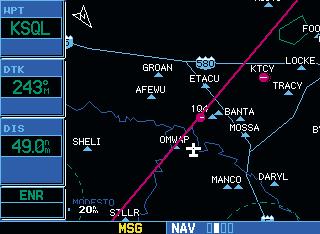
9 Map Page Map Page Map Display (Optional) Data Fields can appear on the right-hand side of the page To Quickly Declutter the Map Display 1. Press the CLR key momentarily (as often as needed) to select the desired amount of map detail. The declutter level (-1, -2 or -3) will appear adjacent to the map scale. Map Scale The following symbols are used to depict the various airports and navaids on the Map Page: Airport with Hard surface runway(s); Primary runway shown Airport with Soft surface runway(s) only Private Airfield VOR VOR/DME DME Localizer To Select a Map Scale Intersection VORTAC TACAN NDB Present Position Locator Outer Marker 1. Press the up arrow side of the RNG key to zoom out to a larger map area. 2. Press the down arrow side of the RNG key to zoom in to a smaller map area and more detail. To Turn the Data Fields On Along the Right-hand Side of the Map Page 1. With the Map page displayed, press MENU to display an options menu. 2. Rotate the large right knob to highlight Data Fields On?, then press ENT. 3. To return to a full-screen map display, follow steps 1 and 2, but instead select Data Fields Off? from the options menu. To Select a Different Data Item for any Data Field along the Right-hand Side of the Map Page 1. With the Map page displayed, press the MENU key to display an options menu. 2. Rotate the large right knob to highlight the Change Fields? option, and press ENT to select this option. 3. Use the large right knob to highlight the data field you wish to change. 4. Rotate the small right knob to display a list of available data items. Continue rotating the small right knob to select the desired data item from the list. 5. Press ENT to select the desired data item and return to the Map page. 6. Press the small right knob to remove the cursor from the page. 9
 Annunciator (RAIM protection limit failure) Message Annunciator: Flashing (new message), On, or blank (no message) Usage Restriction Information Assigned Frequency The NAVCOM page")
10 NavCom Page / Annunciators & Messages NAVCOM Page Frequency Category Departure, Enroute or Arrival Airport Scroll Bar Bottom Row Annunciators and Messages Integrity Failure (INTEG) or Position Warning (WARN) Annunciator (RAIM protection limit failure) Message Annunciator: Flashing (new message), On, or blank (no message) Usage Restriction Information Assigned Frequency The NAVCOM page provides a list of the airport communication and navigation frequencies at your departure, enroute and arrival airports. To Select a Frequency List for a Departure, Enroute or Arrival Airport 1. Press the small right knob to activate the cursor. 2. Rotate the large right knob to place the cursor on the airport identifier field (top line on the NAVCOM page). 3. Rotate the small right knob to select the desired airport and press ENT. To Scroll Through the List of Frequencies Activate the cursor, if not already active, by pressing the small right knob. 2. Rotate the large right knob to move the cursor through the list of frequencies. If there are more frequencies in the list than can be displayed on the screen, a scroll bar along the right-hand side of the screen will indicate which part of the list is currently being displayed. OBS Mode: Suspend (SUSP), OBS or blank (for auto-sequencing) CDI/RAIM Mode: Approach (APR), Terminal (TERM), or Enroute (ENR) Page Annunciator (NAV/WPT/AUX/ NRST/FPL/VNAV/PROC), Waypoint Alert ( NEXT DTK ), Turn Advisory ( TURN TO ), etc.
 1. With the cursor off, rotate the large right knob to select the NRST page group.")


11 Nearest Airports To View a List of the Nearest Airports A list of the nearest airports can always be selected by pressing the NRST key. You can also scroll through the pages using the large and small right knobs. (See page 5.) 1. With the cursor off, rotate the large right knob to select the NRST page group. NRST will appear in the lower right corner of the screen. 2. If necessary, rotate the small right knob to select the Nearest Airport page. To Scroll Through the List of Nearest Airports 1. Press the small right knob to activate the cursor. 2. Rotate the large right knob to scroll through the list. The scroll bar along the right-hand side of the page will indicate which part of the list is currently being viewed. 3. To remove the flashing cursor, press the small right knob. To ViewAdditional Information for a Nearby Airport 1. Highlight the identifier of the desired airport by scrolling through the list, as described in the procedure above. 2. Press ENT to display the Airport Location page for the selected airport. 3. To view additional WPT pages for the selected airport (including the Airport Runway and Airport Frequency pages) press the small right knob to remove the flashing cursor. Rotate the small right knob to display the additional WPT pages. When finished, press the small right knob to return the flashing cursor to the screen. 4. To return to the Nearest Airport page, verify that Done? is highlighted by the flashing cursor and press ENT (or press CLR). To Select a Nearby Airport as a Direct-To Destination 1. Press the direct-to key. The Select Direct-To Waypoint page will appear, with the waypoint identifier field highlighted. 2. Rotate the large right knob to highlight the nearest airport (NRST) field. 3. Rotate the small right knob to display a window showing up to nine nearby airports. 4. Continue rotating the small right knob to scroll through the list and highlight the desired airport. 5. Press ENT to confirm the selected airport, and press ENT a second time (with Activate? highlighted) to begin navigating to the selected waypoint. 11


12 Flight Plans To Create a New Flight Plan 1. Press FPL and rotate the small right knob to display the Flight Plan Catalog. 2. Press MENU to display the Flight Plan Catalog options. 3. Rotate the large right knob to highlight Create New Flight Plan? and press ENT. 4. A blank flight plan page will appear for the first empty storage location. Use the small and large right knobs to enter the identifier of the departure waypoint and press ENT. 5. Repeat step #4 above to enter the identifier for each additional flight plan waypoint. 6. Once all waypoints have been entered, press the small right knob to return to the Flight Plan Catalog. To Navigate a Flight Plan 1. Press FPL and rotate the small right knob to display the Flight Plan Catalog. 2. Press the small right knob to activate the cursor. 3. Rotate the large right knob to highlight the desired flight plan and press MENU to display the Flight Plan Catalog options. 4. Rotate the large right knob to highlight Activate Flight Plan? and press ENT. 12 To Stop Navigating a Flight Plan 1. Press FPL. The Active Flight Plan page will appear. 2. Press MENU to display the Active Flight Plan options. 3. Rotate the large right knob to highlight Delete Flight Plan? and press ENT. 4. Press ENT again to confirm. To Edit a Flight Plan 1. Press FPL and rotate the small right knob to display the Flight Plan Catalog. 2. Press the small right knob to activate the cursor. 3. Rotate the large right knob to highlight the desired flight plan and press ENT. 4. To add a waypoint to the flight plan: Rotate the large right knob to select the point where you wish to add the new waypoint. (If an existing waypoint is highlighted, the new waypoint will be placed directly in front of this waypoint.) Use the small and large right knobs to enter the identifier of the new waypoint and press ENT. 5. To delete a waypoint from the flight plan: Rotate the large right knob to select the waypoint you wish to delete and press CLR to display a remove waypoint confirmation window. With Yes? highlighted, press ENT to remove the waypoint. 6. Once all changes have been made, press the small right knob to return to the Flight Plan Catalog.


 6.")
13 Approaches Selecting Approaches In order to select an approach, you must first have an active direct-to or flight plan which terminates at an airport with a published approach. 1. Press the PROC key to display the Procedures page. 2. Rotate the large right knob to highlight Select Approach? and press ENT. 3. A window will appear listing the available procedures. Rotate the large right knob to highlight the desired procedure and press ENT. 4. A second window will appear listing the available transitions. Rotate the large right knob to highlight the desired transition waypoint and press ENT. (The approach Vectors option assumes you will receive vectors to the final course segment of the approach and will provide navigation guidance relative to the final approach course.) 5. Rotate the large right knob to highlight Load? or Activate? and press ENT. ( Load? will add the procedure to the flight plan without immediately using it for navigation guidance. This allows you to continue navigating the original flight plan, but keeps the procedure available on the Active Flight Plan page for quick activation when needed. Activate? overrides the enroute portion of the active flight plan, proceeding directly to the approach portion.) 6. For precision approaches and some nonprecision approaches, a reminder window will appear indicating that GPS guidance on such approaches is strictly for monitoring only use an external VOR/ILS receiver and CDI (or HSI) for primary navigation. To confirm this reminder, highlight Yes? and press ENT. Not all approaches in the database are approved for GPS use. As you select an approach, a GPS designation to the right of the procedure name indicates the procedure can be flown using the GPS receiver. Some procedures will not have this designation, meaning the GPS receiver may be used for supplemental navigation guidance only. If the GPS receiver cannot be used for primary guidance, you must use the appropriate receiver for the selected approach (e.g., VOR or NDB). The final course segment of ILS approaches, for example, must be flown by tuning the external VOR/ILS receiver to the proper frequency. A selected approach may be activated or loaded. Loading the approach adds the procedure to the flight plan without immediately using it for navigation guidance. You can continue navigating the original flight plan, but the procedure is available for quick activation when needed. Activating the approach overrides the enroute portion of the active flight plan, proceeding directly to the approach portion. Activating the approach also initiates automatic CDI scaling transition as the approach progresses. In many cases, it may be easiest to Load the full approach while still some distance away, enroute to the destination airport. Later, if vectored to final, use the following steps to select Activate Vector-To-Final which makes the inbound course to the FAF waypoint active. Otherwise, activate the full approach using the Activate Approach? option. 13
14 Approaches Activating an Approach 1. With an approach loaded in the active flight plan, press the PROC key to display the Procedures page. 2. Rotate the large right knob to highlight Activate Approach?. 3. Press ENT. Activating an Approach with Vectors-to-Final The Activate Vectors-To-Final? option allows you to activate the final course segment of the approach. This option assumes you will receive vectors to the final approach fix (FAF) and guides you to intercept the final course, before reaching the FAF. 1. With an approach loaded in the active flight plan, press the PROC key to display the Procedures page. 2. Rotate the large right knob to highlight Activate Vectors-To-Final?. 3. Press ENT. Due to the variety of available approach procedures, the specific steps required will vary according to the approach selected. Keep the following guidelines in mind while flying the approach: The GPS 500 is designed to complement your printed approach plates and vastly improve situational awareness throughout the approach. However, you must always fly an approach as it appears on the approach plate. You will typically select the destination airport as the last waypoint in the active flight plan or use the direct-to key. Doing so ensures that the desired waypoint will automatically appear when choosing the Select Approach? option for the Procedures page. (Otherwise, you must first choose the airport, then the approach procedure.) As you progress to each waypoint, a waypoint alert message (e.g., NEXT DTK ### ) will appear in the lower right corner of the display. (See page 10.) When you should begin a course change (via a standard rate turn), turn advisories ( TURN TO ### ) will appear in the lower right corner of the display. (See page 10.) 14
 if protection limits cannot be maintained. If this occurs, the GPS receiver should not be used for primary navigation guidance.")
15 Approaches For GPS-based approaches, receiver autonomous integrity monitoring (RAIM) will monitor satellite conditions and alert you using an INTEG or WARN annunciation at the bottom left corner of the display (see page 10) if protection limits cannot be maintained. If this occurs, the GPS receiver should not be used for primary navigation guidance. Revert to an alternate navigation source, such as an external VOR/ILS receiver, or select an alternate destination airport. Within 30 nautical miles of the destination airport, CDI scaling will transition from 5.0 nautical miles (enroute mode; or ENR ) to 1.0 nautical mile (terminal mode; or TERM ) or when leaving the departure airport, from 1.0 nm to 5.0 nm. Within 2.0 nautical miles of the final approach fix, GPS-based approaches will see a second transition from 1.0 nautical mile to 0.3 nautical mile (approach mode; or APR ). A START PROC TURN prompt will appear in the lower right corner of the display to remind you to initiate a procedure turn (if you haven t already begun the procedure turn). The procedure turn is displayed on the Default NAV and Map pages, but guidance through the turn itself is not provided. Alerts for proper holding pattern entry (e.g., HOLD DIRECT ) are displayed in the lower right corner of the display. Waypoint sequencing is automatically suspended (indicated by SUSP directly above the OBS key) at the holding waypoint. Press the OBS key again to return to automatic waypoint sequencing. For course reversals, waypoint sequencing is suspended for one trip around the holding pattern only (after which it will return to automatic waypoint sequencing). The CDI will guide you through a DME arc. Just keep the needle centered as you fly along the arc. When using an autopilot, the course select on the CDI (or HSI) must be periodically updated with the desired track (DTK). As you cross the missed approach point (MAP), SUSP will appear above the OBS key, indicating that automatic sequencing of waypoint is suspended at the missed approach point, and a FROM indication will appear on the CDI (or HSI). Flying the Missed Approach 1. After crossing the missed approach point, press the OBS key. The next waypoint in the approach is automatically offered as the destination waypoint. 2. Follow the missed approach procedures, as published on your approach plate, for proper climb and heading instructions. 3. An alert message in the lower right hand corner of the screen will recommend entry procedures for a holding pattern (i.e., HOLD DIRECT, HOLD PARALLEL, or HOLD TEARDROP ). As you fly the holding pattern, a timer appears on the Default NAV page. The timer automatically resets on the outbound side of the hold when you are abeam the hold waypoint. The timer again resets as you turn inbound (within approximately 30 of the inbound course). This allows you to use standard timing (typically one minute) to fly the inbound and outbound legs of the hold. 4. The GPS 500 will provide course guidance only on the inbound side of the holding pattern. When leaving the holding pattern to re-fly the approach (or another approach) press the PROC key to Select Approach? or Activate Approach? as previously described. (Or, use the direct-to key to select another destination.) 15
16 2001 GARMIN Corporation GARMIN International, Inc East 151 st Street, Olathe, Kansas 66062, U.S.A. GARMIN (Europe) Ltd. Unit 5, The Quadrangle, Abbey Park Industrial Estate, Romsey, SO51 9AQ, U.K. GARMIN Corporation No. 68, Jangshu 2 nd Road, Shijr, Taipei County, Taiwan Part Number Rev. A 16
Range (map scale) Menu. COM power/volume. COM flip-flop. Direct-To. Enter. VLOC flip-flop. VLOC volume. Clear. Small right knob.
 Menu. COM power/volume. COM flip-flop. Direct-To. Enter. VLOC flip-flop. VLOC volume. Clear. Small right knob.") GNS 430 Quick Reference KEYS AND KNOBS Left-hand Keys and Knobs Right-hand Keys and Knobs COM power/volume VLOC volume COM flip-flop VLOC flip-flop Range (map scale) Direct-To Clear Menu Enter Small left
GNS 430 Quick Reference KEYS AND KNOBS Left-hand Keys and Knobs Right-hand Keys and Knobs COM power/volume VLOC volume COM flip-flop VLOC flip-flop Range (map scale) Direct-To Clear Menu Enter Small left
GNS 430/430A. Quick Reference
 GNS 430/430A Quick Reference KEYS AND KNOBS 1 2 3 4 5 6 7 8 9 10 11 12 13 14 15 16 17 18 1 COM Power/Volume 7 RNG (map range) 13 OBS 2 VLOC Volume 8 MENU 14 MSG (message) 3 COM Flip-flop 9 ENT (enter)
GNS 430/430A. Quick Reference
 GNS 430/430A Quick Reference KEYS AND KNOBS 1 2 3 4 5 6 7 8 9 10 11 12 13 14 15 16 17 18 1 COM Power/Volume 7 RNG (map range) 13 OBS 2 VLOC Volume 8 MENU 14 MSG (message) 3 COM Flip-flop 9 ENT (enter)
FriendlyPanels
 FriendlyPanels Software WARNING This operating manual has been writen following the original GARMIN GNS 430/430A Pilot s Guide and Reference, but it's not intended to be valid for training purposes other
500W Series. Quick Reference
 500W Series Quick Reference 2006-2016 Garmin Ltd. or its subsidiaries This manual reflects the operation of Main System Software version 2.00, 3.00, 4.00, 5.00, 5.10, 5.30, or later. Some differences in
500W Series. Quick Reference
 500W Series Quick Reference 2006-2014 Garmin Ltd. or its subsidiaries This manual reflects the operation of Main System Software version 2.00, 3.00, 4.00, 5.00, 5.10, or later. Some differences in operation
400W Series. Quick Reference Rev K
 400W Series Quick Reference 190-00356-01 Rev K 2006-2016 Garmin Ltd. or its subsidiaries This manual reflects the operation of Main System Software version 2.00, 3.00, 4.00, 5.00, 5.10, 5.30, or later.
400W Series. Quick Reference Rev G
 400W Series Quick Reference 190-00356-01 Rev G 2006-2012 Garmin Ltd. or its subsidiaries This manual reflects the operation of Main System Software version 2.00, 3.00, 4.00, 5.00, or later. Some differences
400W Series. Quick Reference Rev J
 400W Series Quick Reference 190-00356-01 Rev J 2006-2014 Garmin Ltd. or its subsidiaries This manual reflects the operation of Main System Software version 2.00, 3.00, 4.00, 5.00, 5.10, or later. Some
GNS 430(A) Pilot s Guide and Reference
 Pilot s Guide and Reference") GNS 430(A) Pilot s Guide and Reference RECORD OF REVISIONS Revision Date of Revision Description A 12/98 Initial Release B 4/99 Update to conform to recent SW changes C 6/99 Added Addendum D 7/99 Update
GNS 430(A) Pilot s Guide and Reference RECORD OF REVISIONS Revision Date of Revision Description A 12/98 Initial Release B 4/99 Update to conform to recent SW changes C 6/99 Added Addendum D 7/99 Update
GPSMAP 695/696. Portable Aviation Receiver Quick Reference Guide
 GPSMAP 695/696 Portable Aviation Receiver Quick Reference Guide Overview Overview 7 WVGA (800x480) Color Display Power Button Backlit Keypad Unit Overview 1 SD Card Slot External GPS Antenna Connector
G3X. Multi Function Display Quick Reference Guide
 G3X Multi Function Display Quick Reference Guide Overview GPS Navigation Flight Planning Hazard Avoidance Additional Features Appendices Index Warnings, Cautions & Notes WARNING: The indicators represented
GDU 37X. Multi Function Display Quick Reference Guide
 GDU 37X Multi Function Display Quick Reference Guide OVERVIEW GPS NAVIGATION FLIGHT PLANNING HAZARD AVOIDANCE ADDITIONAL FEATURES APPENDICES INDEX Copyright 2008-2009, 2012 Garmin Ltd. or its subsidiaries.
owner s manual Garmin Mobile
 owner s manual Garmin Mobile 2008 Garmin Ltd. or its subsidiaries Garmin International, Inc. 1200 East 151st Street, Olathe, Kansas 66062, USA Tel. (913) 397-8200 or (800) 800-1020 Fax (913) 397-8282 Garmin
simplugins Panel Builder
 simplugins Panel Builder ADD-ON MFD GPS BajuSoftware, LLC Page 1 of 38 Version 1.4 April, 2015 Table of Contents Introduction... 3 Technical Requirements... 5 Installation Procedure... 6 Running the GPS
models: 795 and 796 Quick Reference Guide
 models: 795 and 796 Quick Reference Guide OVERVIEW GPS NAVIGATION FLIGHT PLANNING HAZARD AVOIDANCE UTILITIES APPENDIX INDEX Copyright 2011, 2012, 2017 Garmin Ltd. or its subsidiaries. All rights reserved.
G1000TM. system overview for the Diamond DA40
 G1000TM system overview for the Diamond DA40 Record of Revisions Revision Date of Revision Revision Page Range Description A 02/14/05 2-1 2-15 Initial release. Garmin G1000 System Overview for the DA40
model: 660 Quick Start Manual
 model: 660 Quick Start Manual Copyright 2016 Garmin Ltd. or its subsidiaries. All rights reserved. This manual reflects the operation of System Software version 1.0 or later. Some differences in operation
1.- Introduction Pages Description 19.- Tutorial 20.- Technical support
 FriendlyPanels Software WARNING This operating manual has been written to be used only with Microsoft Simulator. FriendlyPanels www.friendlypanels.net fpanels@friendlypanels.net Flight Table of Contents
model: 660 Quick Start Manual
 model: 660 Quick Start Manual Copyright 2016-2018 Garmin Ltd. or its subsidiaries. All rights reserved. This manual reflects the operation of System Software version 3.3 or later. Some differences in
ique 3600a integrated handheld
 ique 3600a integrated handheld Que applications guide Copyright 2004 Garmin Ltd. or its subsidiaries Garmin International, Inc. 1200 East 151st Street, Olathe, Kansas 66062, U.S.A. Tel. 913/397.8200 or
GPS 72H. quick start manual
 GPS 72H quick start manual 190-01119-01_0A.indd 1 7/22/2009 3:44:22 PM See the Important Safety and Product Information guide in the product box for product warnings and other important information. Manual
The Garmin GNS 430W. A Pilot-Friendly 3V5 KGXY KFNL ICT KLMO KDEN CDI OBS MSG FPL PROC TERRAIN KLMO KDEN KGXY CDI OBS MSG FPL PROC
 The Garmin GNS 430W A Pilot-Friendly Manual GARMIN PWR VOL VOL.C.V SQ ID C/V GARMIN PWR VOL VOL.C SQ ID C/V C V COM VLOC C.V V COM VLOC COM 125.900 122.800 VLOC 114.200 113.800 ENR GPS ICT 3V5 KFNL KLMO
G1000 Integrated Flight Deck. Cockpit Reference Guide for the Quest Kodiak 100
 G1000 Integrated Deck Cockpit Reference Guide for the Quest Kodiak 100 Instruments Engine indication system Transponder/Audio Panel GPS Navigation Planning Procedures Operation Annunciations & Alerts
GPSMAP 96/96C portable aviation receiver. pilot s guide
 GPSMAP 96/96C portable aviation receiver pilot s guide 2006 Garmin Ltd. or its subsidiaries Garmin International, Inc. 1200 East 151 st Street, Olathe, Kansas 66062, U.S.A. Tel. 913/397.8200 or 800/800.1020
2 MOVING MAP. Set Up Moving Map Display. Set the Chart Theme
 2 MOVING MAP The Moving Map provides you with position information when connected to an approved GPS receiver. Set Up Moving Map Display To meet your needs, FliteMap provides numerous options for setting
TMF. Vertical Nav & +MAP James D Price TMF
 TMF Vertical Nav & +MAP 2013 James D Price TMF Vertical Navigation If you are not at the NAV page, simple Press and hold the xxclrxx button. This will put you at the Default NAV page. Rotate the small
2005 Buick Rendezvous Navigation System M
 2005 Buick Rendezvous Navigation System M Overview... 1-1 Overview... 1-2 Features and Controls... 2-1 Features and Controls... 2-2 Navigation Audio System... 3-1 Navigation Audio System... 3-2 Index...1
Welcome to part 3 of the factory navigation system tutorial. You can find the second installment available for download also on my website here:
 Section 5 Waypoints Welcome to part 3 of the factory navigation system tutorial. Please note that this tutorial is not intended to replace the OEM Navigation system manual nor is it intended to be all
System Overview. Flight Instruments. Flight Planning. Hazard Avoidance. Additional Features. Integrated Autopilot. Annunciations & Alerts.
 G300 Pilot s Guide Instruments EIS Autopilot Annunciations & Alerts Appendix INDEX Copyright 2009, 2010 Garmin Ltd. or its subsidiaries. All rights reserved. This manual reflects the operation of Software
Precautions Very important information. Please read this section carefully before using this product.
 Precautions Very important information. Please read this section carefully before using this product. This product is intended to provide turn-by-turn instructions to safely guide you to your desired destination.
2006 HUMMER H3 Navigation System M
 2006 HUMMER H3 Navigation System M Overview... 1-1 Overview... 1-2 Features and Controls... 2-1 Features and Controls... 2-2 Navigation Audio System... 3-1 Navigation Audio System... 3-2 Index... 1 GENERAL
Aeronautical Navigator USER MANUAL. Your Journey, Our Technology
 Aeronautical Navigator USER MANUAL Your Journey, Our Technology INDEX Navigatore Aeronautico AvMap EKPV 1. LEARN BEFORE USE 4 I. Safe temperature range 4 II. Battery and power source recommendations 4
GTN 725/750 SOFTWARE v6.20 PILOT S GUIDE UPGRADE SUPPLEMENT
 GTN 725/750 SOFTWARE v6.20 PILOT S GUIDE UPGRADE SUPPLEMENT This supplement contains the pages revised in the GTN 725/750 Pilot s Guide, P/N 190-01007-03, Rev N, regarding the new features of software
nüvi quick start manual
 nüvi 785 quick start manual 2009 Garmin Ltd. or its subsidiaries Garmin International, Inc. 1200 East 151st Street, Olathe, Kansas 66062, USA Tel. (913) 397.8200 or (800) 800.1020 Fax (913) 397.8282 Garmin
Boating Tip #45: Chartplotters
 Boating Tip #45: Chartplotters As navigation technology has advanced, hand held GPS receivers have further evolved into chartplotters. Chartplotters graphically display a vessel s position, heading and
Odyssey Quick Start Guide. Version:
 Odyssey Quick Start Guide Version: 2009.3 2 Odyssey Quick Start Guide Copyright About Version: 2009.3 Doc. Date: 20 February 2009 Copyright Copyright 2006-2009. All rights reserved. No part of this publication
LX700 V1.0. GPS Navigation System
 LX700 V1.0 GPS Navigation System 1 Contents 1 CONTENTS... 1 2 GENERAL... 3 2.1 TECHNICAL DATA... 3 2.2 ROTARY SWITCHES AND KEYS (BUTTONS)... 3 2.2.1 On/Start Button (ON/START)... 4 2.2.2 MODE selector
USER S MANUAL SOLO PRO. User s Manual. Rev 1.1 June VirtualFly, S.L. tel
 User s Manual Rev 1.1 June 2016 1 TABLE OF CONTENTS 1. IDENTIFICATION OF ELEMENTS 2. INSTALLATION 3. START UP 4. SELECTION OF PANEL TYPE (according to plane) 5. ANALOGIC PANEL INDICATORS 6. RADIOSTACK
SOFTWARE SERVICE BULLETIN NO.: 0740 Rev A
 SOFTWARE SERVICE BULLETIN NO.: 0740 Rev A TO: All Garmin Aviation Service Centers DATE: SUBJECT: 400W / 500W Series Unit s software upgrade to Main Software version 3.00 & GPS Software version 3.0 PURPOSE
fsaerodata Navigation Database
 fsaerodata Navigation Database Flight Simulator FSX Flight Simulator FSX Steam Prepar3D User Manual Vers. 1.31 Web: www.fsaerodata.com email/support: support@fsaerodata.com Copyright: @2016 fsaerodata
Navigation System... 1 Radio Frequently Asked Questions Troubleshooting MAIN TABLE OF CONTENTS
 Navigation System... 1 Radio... 41 Frequently Asked Questions... 53 Troubleshooting... 56 MAIN TABLE OF CONTENTS i NAVIGATION SYSTEM TABLE OF CONTENTS Safety Guidelines... 1 System Introduction... 3 System
USER S MANUAL Duo Flight Panel. User s Manual. Rev 1.0 June VirtualFly, S.L. tel
 User s Manual Rev 1.0 June 2015 1 TABLE OF CONTENTS 1. IDENTIFICATION OF ELEMENTS 2. INSTALLATION 3. START UP 4. SELECTION OF PANEL TYPE (according to plane) 5. ANALOGIC PANEL INDICATORS 6. RADIOSTACK
Aerobask Skyview. Addendum for v2 ONLY FOR SIMULATION DO NOT USE FOR REAL FLIGHT. Aerobask Syview v2 addendum
 Aerobask Skyview Addendum for v2 ONLY FOR SIMULATION DO NOT USE FOR REAL FLIGHT Page 1/10 Table of Contents INTRODUCTION...3 Before You Fly...3 Targeted audience...3 CUSTOM DATABASE CHANGES...3 CLICK ZONES...4
AFMS, Garmin G5 AML STC Rev. 3 Page 2 of 10
 LOG OF REVISIONS Rev Page Description Date of Approval FAA Approval 1 All Original Issue 7/22/2016 Robert Murray ODA STC Unit Administrator 2 All Added information regarding G5 DG/HSI 4/28/2017 Robert
USER S MANUAL Solo Flight Panel. User s Manual. Rev 1.6 October VirtualFly, S.L. tel
 User s Manual Rev 1.6 October 2015 1 TABLE OF CONTENTS 1. IDENTIFICATION OF ELEMENTS 2. INSTALLATION 3. START UP 4. SELECTION OF PANEL TYPE (according to plane) 5. ANALOGIC PANEL INDICATORS 6. RADIOSTACK
Version 9 User Guide for. Developed for Omnitracs
 Version 9 User Guide for Developed for Omnitracs Table of Contents Welcome to CoPilot Truck 4 Driving Screen 4 Driving Menu 5 GO TO MENU: Single Destination Navigation 6 Address 6 My Places 7 Points of
FliteDeck Pro 9.0. Release Notes. Software Version 9.0
 FliteDeck Pro 9.0 Release Notes Software Version 9.0 Software Version 9.0 Jeppesen 55 Inverness Drive East Englewood, Colorado 80112-5498 Any charts that appear in this publication are for illustration
GPS NAVIGATION SYSTEM DNX7540BT
 GPS NAVIGATION SYSTEM DNX7540BT GPS NAVIGATION INSTRUCTION MANUAL ІНСТРУКЦІЯ З КОРИСТУВАННЯ GPS-НАВІГАТОРОМ РУКОВОДСТВО ПО ЭКСПЛУАТАЦИИ НАВИГАЦИОННОЙ СИСТЕМЫ GPS B64-4525-00 Contents Safety Precautions
2007 HUMMER H3 Navigation System M
 2007 HUMMER H3 Navigation System M Overview... 3 Overview... 4 Features and Controls... 15 Features and Controls... 16 Navigation Audio System... 57 Navigation Audio System... 58 Index... 69 1 GENERAL
zūmo 590 Quick Start Manual
 zūmo 590 Quick Start Manual January 2014 190-01706-01_0A Printed in Taiwan Getting Started WARNING See the Important Safety and Product Information guide in the product box for product warnings and other
NAVIGATION USER MANUAL
 NAVIGATION USER MANUAL POWERED by Welcome Dear Customer, Thank you for selecting NDrive as your navigation software. This guide is created so that you can find quick and simple answers to your questions,
StreetPilot III. portable GPS with auto-routing and voice. owner s manual and reference guide
 StreetPilot III portable GPS with auto-routing and voice owner s manual and reference guide 2001 GARMIN Corporation GARMIN International, Inc. 1200 E 151 st Street, Olathe, Kansas 66062 U.S.A. Tel. 913/397.8200
Table of contents. Main Map Screen... 2 Basic Commands... 5 Exploring menu screens... 5 Using keyboards... 5 Performing a search...
 Table of contents Welcome!... 2 Main Map Screen... 2 Basic Commands... 5 Exploring menu screens... 5 Using keyboards... 5 Performing a search... 7 Go screen... 7 How to Navigate... 8 Navigate to an address...
quick start manual nüvi 880 personal travel assistant with MSN Direct
 quick start manual nüvi 880 personal travel assistant with MSN Direct 2008 Garmin Ltd. or its subsidiaries Garmin International, Inc. 1200 East 151st Street, Olathe, Kansas 66062, USA Tel. (913) 397.8200
MINIMUM EQUIPMENT LIST REGISTRATION: SERIAL #:
 23 COMMUNICATIONS 23-1 -05-1 Radio Management Unit (RMU) (Honeywell Equipped Aircraft Only) -10-1 Communications System (VHF & UHF) -10-2 High Frequency (HF) Communication System C 2 1 (O) One may be inoperative
GN70/MX610/MX612 QuickStart Guide
 GN70/MX610/MX612 QuickStart Guide EN The front panel 1 2 3 PAGE MENU 8 10 POS NAV 9 HDG AIS 11 4 5 6 ESC MOB 7 ENT USB 12 13 USB No. Description 1 PAGE key: Brings up different screen page every time this
StreetPilot III. portable GPS with auto-routing and voice. owner s manual and reference guide
 StreetPilot III portable GPS with auto-routing and voice owner s manual and reference guide 2001 GARMIN Corporation GARMIN International, Inc. 1200 E 151 st Street, Olathe, Kansas 66062 U.S.A. Tel. 913/397.8200
Apollo GX 50/55 SAR Functions
 Apollo GX 50/55 SAR Functions Bob Wolin, Lt. Col. CAP Sugar Land Composite Squadron This presentation is based on materials from Nighthawk Composite Squadron - TX-413 Denton, Texas Introduction Introduce
NVX226 Navigation System. User s Manual
 NVX226 Navigation System User s Manual 1287693 Contents Getting started-------------------------------------------------------------------------------------- 1 Charging the battery -------------------------------------------------------------------------------
2009 Navigation System
 Customer Experience Center 1-800-331-4331 009 Navigation System Quick Reference Guide MN 00505-NAV09-COR Printed in USA 1/07 TABLE OF CONTENTS LIMITATIONS OF THIS QUICK REFERENCE GUIDE 1 BASIC OPERATION
2005 GMC Yukon/Yukon XL, Yukon Denali/Yukon Denali XL Navigation System M
 2005 GMC Yukon/Yukon XL, Yukon Denali/Yukon Denali XL Navigation System M Overview... 1-1 Overview... 1-2 Features and Controls... 2-1 Features and Controls... 2-2 Navigation Audio System... 3-1 Navigation
owner s manual and reference
 owner s manual and reference 2001 GARMIN Corporation GARMIN International, Inc., 1200 E 151 st Street, Olathe, Kansas 66062 U.S.A. Tel. 913/397.8200 or 800/800.1020 Fax. 913/397.8282 GARMIN (Europe) Ltd.,
Odyssey Mobile User's Guides. Version: 3.0
 Odyssey Mobile User's Guides Version: 3.0 Last Update: 22-June-2006 2 Odyssey Mobile User s Guide Copyright About Odyssey Mobile Version: 3.0 Documentation Date: 22-June-2006 Copyright Copyright 2005-2006.
gsfgdsgsf GPS Navigation User Guide
 gsfgdsgsf TM GPS Navigation User Guide CONTENTS NAVIGATION Selecting on or off road modes... 3 STREET NAVIGATION Getting started with street navigation... 4 Navigating to an address... 4 Using the on screen
montana 600 series quick start manual for use with models 600, 650, 650t Montana 600 Series Quick Start Manual 1
 montana 600 series quick start manual for use with models 600, 650, 650t Montana 600 Series Quick Start Manual 1 Getting Started warning See the Important Safety and Product Information guide in the product
GX55 GPS Exercises. These exercises and this document were developed by 1Lt David Yost of the St. Croix Composite Squadron, MN Wing, Civil Air Patrol.
 The purpose of this document is to give you some useful hands-on practice with the Apollo GX55 GPS unit installed in most CAP airplane. The exercises can be done in the airplane with the actual GPS unit
- User Guide for iphone.
 - User Guide for iphone. Update to: ios 3.7 Main "Map view" screen: Map objects: Orange icon shows your current location. Important: If there is an error in identifying your location, please check the
Approved GPS and Software List For Vizion PMA Autopilot And Procedure for Approving Additional GPS or Software
 Approved GPS and Software List For Vizion PMA Autopilot And Procedure for Approving Additional GPS or Software RESTRICTION ON USE, DUPLICATION, DISCLOSURE OF PROPRIETARY INFMATION THIS DOCUMENT CONTAINS
PRIME/ESSENTIAL NAVIGATION QUICK START GUIDE
 PRIME/ESSENTIAL NAVIGATION QUICK START GUIDE EN Initial set-up 1. Select your preferred language, then tap to confirm your selection. Later you can change it in Regional settings. 2. Read the End User
2005 Mid-Size Truck Navigation System M
 2005 Mid-Size Truck Navigation System M Overview... 1-1 Overview... 1-2 Features and Controls... 2-1 Features and Controls... 2-2 Navigation Audio System... 3-1 Navigation Audio System... 3-2 Index...
Service Bulletin No.: D42L Rev 0 Date Issued: 11 Dec 2017 Title: G1000 System Software version Update for DA42 L360 Aircraft
 Page: 1 of 22 1. ATA Code: 3400 2. Effectivity: All DA42 aircraft with TCCA STC SA09-54 or FAA STC SA02725NY installed and (Wide Area Augmentation System (WAAS) capable) with GIA 63W LRU installed. 3.
Installation Manual. Caution: Preliminary. Due to software development occurring at this time, this manual may contain inaccuracies and omissions.
 Installation Manual Caution: Preliminary Due to software development occurring at this time, this manual may contain inaccuracies and omissions. Manual Version: Preliminary Date: 10/18/04 Grand Rapids
2009 Chevrolet Corvette Navigation System M
 2009 Chevrolet Corvette Navigation System M Overview... 1-1 Overview... 1-2 Features and Controls... 2-1 Features and Controls... 2-2 Navigation Audio System... 3-1 Navigation Audio System... 3-2 Voice
User Manual Alpine Navigation
 User Manual Alpine Navigation Navigation software for the Alpine INE-W960/INE-W960S/INE-NAV-60 US English January 2015, ver. 1.0 Thank you for choosing the Alpine unit as your navigator. Start using your
Quest 2 pocket-sized navigator. Owner s Manual
 Quest 2 pocket-sized navigator Owner s Manual 2006 Garmin Ltd. or its subsidiaries Garmin International, Inc. 1200 East 151 st Street, Olathe, Kansas 66062, U.S.A. Garmin (Europe) Ltd. Unit 5, The Quadrangle,
MGL Avionics. Odyssey and Voyager G1 and G2. Interactive Map and Flightplan tool
 MGL Avionics Odyssey and Voyager G1 and G2 Interactive Map and Flightplan tool Table of Contents Introduction...3 Opening the IMFT...4 The IMFT in Waypoint mode...5 The IMFT in Goto mode...6 The IMFT in
RNP APPROACHES Foreword A330 & A340
 RNP APPROACHES Foreword A330 & A340 RNP Approach A330_A340_foreword 1 Background for RNP APCH (RNAV GPS/GNSS APPROACH) EASA (European Aviation Safety Agency) has issued an AMC 20 27 (Acceptable Means of
Reference Guide VIB 10/11. (VIB 10 pictured) vehicle integration box
 vehicle integration box") VIB 10/11 Reference Guide (VIB 10 pictured) vehicle integration box 2006 2008 Garmin Ltd. or its subsidiaries Garmin International, Inc. Garmin (Europe) Ltd. 1200 East 151st Street, Liberty House Olathe,
VIB 10/11 Reference Guide (VIB 10 pictured) vehicle integration box 2006 2008 Garmin Ltd. or its subsidiaries Garmin International, Inc. Garmin (Europe) Ltd. 1200 East 151st Street, Liberty House Olathe,
SatGuide Symbian User Manual. SatGuide Symbian OS USER MANUAL
 SatGuide Symbian User Manual SatGuide Symbian OS USER MANUAL CONTENTS 1 - INTRODUCTION...1 WHAT IS SATGUIDE?...1 SATGUIDE FEATURES...1 2 - SMART PRACTICES WHILE DRIVING...2 DRIVE SAFE, CALL SMART SM...2
AT01 AIRPLANE FLIGHT MANUAL
 1.0 General The airplane is equipped with a Bendix / King KMD 150 Multifunction Display / GPS Navigator herein referred as the Navigator. The KMD 150 is capable of providing VFR (IFR) enroute and terminal
quick start manual F O R E R U N N E R 4 0 5
 quick start manual F O R E R U N N E R 4 0 5 GPS-ENABLED SPORTS WATCH WITH WIRELESS SYNC Warning: This product contains a non-replaceable lithium-ion battery. See the Important Safety and Product Information
Aeronautical Navigator USER MANUAL. Update Software version V R. Your Journey, Our Technology
 Aeronautical Navigator USER MANUAL Update Software version V1.6.069R Your Journey, Our Technology INDEX Navigatore Aeronautico AvMap EKPV 1. LEARN BEFORE USE 4 I. Safe temperature range 4 II. Battery
Welcome! Presented by Paul Pearson National Corvette Museum, August 28, 2014
 Welcome! Presented by Paul Pearson National Corvette Museum, August 28, 2014 Linking IP to Driver Mode Selector If your car IP gauges don t change when you turn the driver mode selector, you just need
etrex personal navigator TM owner s manual
 etrex personal navigator TM owner s manual 2000-2003 Garmin Ltd. or its subsidiaries Garmin International, Inc. 1200 East 151 st Street, Olathe, Kansas 66062 U.S.A. Tel. 913/397.8200 Fax 913/397.8282 Garmin
Table of. Contents Getting started 2. Introduction 1. Map settings 3. Setting a destination 4. Route guidance 5. Storing a location/route 6
 FOREWORD Thank you for purchasing a NISSAN vehicle. This user s manual is for the navigation system only. This manual contains operating instructions for the NISSAN Navigation System offered in your NISSAN
1. Select your preferred language, then tap to confirm your selection. Later you can change it in Regional settings.
 Initial set-up 1. Select your preferred language, then tap to confirm your selection. Later you can change it in Regional settings. 2. Read the End User Licence Agreement, and tap if you agree with the
Learn how to enter a destination and operate the navigation system.
 NAVIGATION Learn how to enter a destination and operate the navigation system. Basic Navigation Operation A real-time navigation system uses GPS and a map database to show your current location and help
Diamond DA 40 & DA 40 F
 G1000 Field Update Instructions Diamond DA 40 & DA 40 F FAA STC #SA01254WI Amendment 2 (Includes ADF, DME, GDL 69 Upgrade) 190-00544-01 September, 2005 Revision A Copyright 2005 Garmin Ltd. or its subsidiaries
etrex personal navigator owner s manual
 etrex personal navigator owner s manual 2000 GARMIN Corporation GARMIN International, Inc. 1200 East 151 st Street, Olathe, Kansas 66062 U.S.A. Tel. 913/397.8200 Fax 913/397.8282 GARMIN (Europe) Ltd. Unit
User guide. DRIVE 10s Sygic, a.s. All rights reserved.
 User guide DRIVE 10s 2014 Sygic, a.s. All rights reserved. ... 1 I. Getting Started... 1 The Navigation Screen... 1 Entering an Address... 2 Turn by Turn Navigation... 6 Acquiring GPS Position... 7 II.
Before Using the Navigation System
 Before Using the Navigation System WARNING Read this manual first Read this manual carefully before using the navigation system. We are not liable for accidents or other problems resulting from failure
MCP combo panel USER MANUAL (MEA OCT09A) Please read this manual before operating your units and keep it for future reference.
 Please read this manual before operating your units and keep it for future reference.") MCP combo panel USER MANUAL (MEA2.520-26OCT09A) Please read this manual before operating your units and keep it for future reference. VRinsight Virtual Reality Insight All stated here is subject to change
MCP combo panel USER MANUAL (MEA2.520-26OCT09A) Please read this manual before operating your units and keep it for future reference. VRinsight Virtual Reality Insight All stated here is subject to change
2007 Buick Rendezvous Navigation System M
 2007 Buick Rendezvous Navigation System M Overview... 3 Overview... 4 Features and Controls... 15 Features and Controls... 16 Navigation Audio System... 59 Navigation Audio System... 60 Index... 73 1 GENERAL
GPS NAVIGATION SYSTEM NAV USER MANUAL
 GPS NAVIGATION SYSTEM NAV USER MANUAL ENGLISH Thank you for choosing the the Zenec Device as your navigator. Start using your device right away. This document is the detailed description of the navigation
GPSMAP color map navigator. owner s manual
 GPSMAP color map navigator owner s manual Copyright 2004 Garmin Ltd. or its subsidiaries Garmin International, Inc. 1200 East 151 st Street Olathe, Kansas 66062, U.S.A. Tel. 913/397.8200 or 800/800.1020
GPSMAP 182/232. chartplotting receiver. owner s manual and reference guide. (GPSMAP 182 shown)
") GPSMAP 182/232 chartplotting receiver (GPSMAP 182 shown) owner s manual and reference guide 2001 GARMIN Ltd. or its subsidiaries GARMIN International, Inc., 1200 East 151 st Street, Olathe, KS 66062, U.S.A.
GPSMAP 182/232 chartplotting receiver (GPSMAP 182 shown) owner s manual and reference guide 2001 GARMIN Ltd. or its subsidiaries GARMIN International, Inc., 1200 East 151 st Street, Olathe, KS 66062, U.S.A.
GPSMAP 60. map navigator. owner s manual
 GPSMAP 60 map navigator owner s manual Copyright 2004 Garmin Ltd. or its subsidiaries Garmin International, Inc. 1200 East 151 st Street, Olathe, Kansas 66062, U.S.A. Tel. 913/397.8200 or 800/800.1020
SERVICE BULLETIN TITLE NAVIGATION - GARMIN G1000 SYSTEM SOFTWARE UPGRADE TO VERSION
 TITLE NAVIGATION - GARMIN G1000 SYSTEM SOFTWARE UPGRADE TO VERSION 0767.13 EFFECTIVITY MODEL SERIAL NUMBERS 208 20800416, 20800500 thru 20800541 208B 208B1190, 208B1216, 208B2000 thru 208B2261, 208B2263
Table of contents 1. INTRODUCTION INSTALLATION GENERAL INTRODUCTION NAVIGATE TO... 7
 Table of contents 1. INTRODUCTION... 1 2. INSTALLATION... 3 2.1. INSTALLING THE HARDWARE...3 2.2. INSTALLING THE SOFTWARE...3 2.3. ACTIVATING THE GPS...4 3 GENERAL INTRODUCTION... 5 3.1. LEFT-HAND BUTTONS...5